Bridge Statistics for Chapel Hill, North Carolina (NC)
Condition, Traffic, Stress, Structural Evaluation, Project Costs
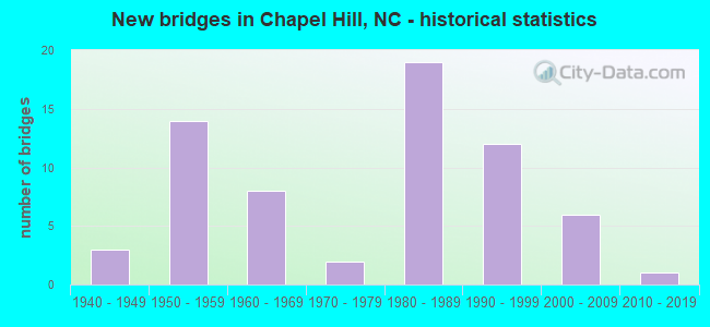
- New bridges - historical statistics
- 31940-1949
- 141950-1959
- 81960-1969
- 21970-1979
- 191980-1989
- 121990-1999
- 62000-2009
- 12010-2019
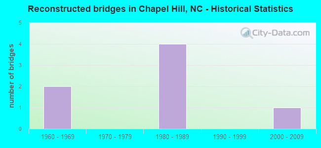
- Reconstructed bridges - Historical Statistics
- 21960-1969
- 01970-1979
- 41980-1989
- 01990-1999
- 12000-2009
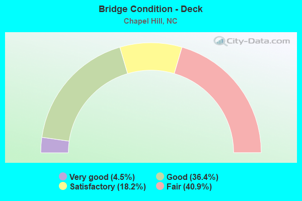
- Bridge Condition - Deck
- 4.5%Very good
- 36.4%Good
- 18.2%Satisfactory
- 40.9%Fair
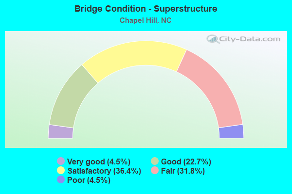
- Bridge Condition - Superstructure
- 4.5%Very good
- 22.7%Good
- 36.4%Satisfactory
- 31.8%Fair
- 4.5%Poor
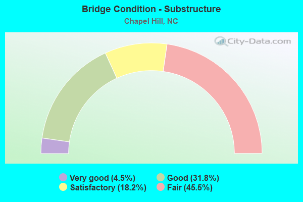
- Bridge Condition - Substructure
- 4.5%Very good
- 31.8%Good
- 18.2%Satisfactory
- 45.5%Fair
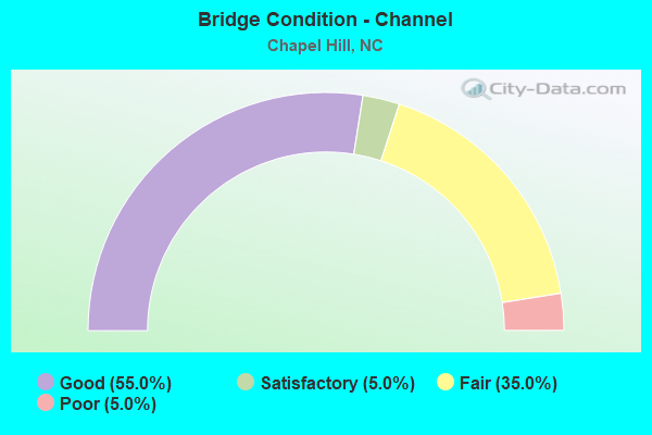
- Bridge Condition - Channel
- 55.0%Good
- 5.0%Satisfactory
- 35.0%Fair
- 5.0%Poor
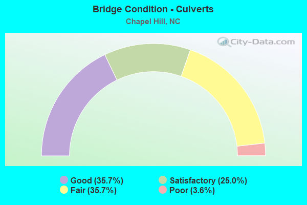
- Bridge Condition - Culverts
- 35.7%Good
- 25.0%Satisfactory
- 35.7%Fair
- 3.6%Poor
Find on map >> Show street view
Structure Number: 1350321, Location: .1 MI.S.JCT.BROOKVIEW DR. (Lat: 35.950825, Lng: -79.033492), Route carried "on" structure: City street , Year Built: 1960, Status: Open, Structure Length: 0.76m (2.49ft), Average Daily Traffic: 3,000 (year 2017), Truck Traffic: 7%, Average Future Daily Traffic: 6,000 (year 2040), Features Intersected: CEDAR FORK CREEK, Facility Carried by Structure: NORTH LAKESHORE DR
Minimum Vertical Clearance: 30+ m (98+ ft), Kilometerpoint: 0.000, Lanes on structure: 2, Owner: City or Municipal Highway Agency, Approaching Roadway Width: 8.8m (28.9ft), Material/Design: Prestressed concrete, Design/Construction: Slab, Number Of Spans In Main Unit: 1, Length of Maximum Span: 6.7m (22.0ft), Curb or Sidewalk Widths: Left: 3.0m (9.8ft), Right: 0.1m (0.3ft), Curb-To-Curb Width: 8.5m (27.9ft), Out-to-Out Width: 12.8m (42.0ft)
Condition: Deck: Good, Superstructure: Good, Substructure: Good, Channel: Good, Operating Rating: 89.8 metric tons, Method Used To Determine Operating Rating: Load Factor (LF), Inventory Rating: 74.3 metric tons, Method Used To Determine Inventory Rating: Load Factor (LF), Structural Evaluation: Better than present minimum criteria, Deck Geometry: Meets minimum limits, Waterway Adequacy: Better than present minimum criteria, Approach Roadway Alignment: Equal to present desirable criteria, Designated Inspection Frequency: Every 24 months, Inspection Date: April 2020, Deck Structure Type: Concrete Precast Panels, Wearing Surface/Protective System: Wearing Surface: Bituminous
Find on map >> Show street view
Structure Number: 1350329, Location: 0.1 MI.E.JCT.GRAYLYN DR. (Lat: 35.880917, Lng: -79.069561), Route carried "on" structure: City street , Year Built: 2004, Status: Open, Structure Length: 0.64m (2.10ft), Average Daily Traffic: 800 (year 2005), Truck Traffic: 7%, Average Future Daily Traffic: 1,600 (year 2040), Design Load: HS 20, Features Intersected: FAN BRANCH CREEK, Facility Carried by Structure: ABERDEEN ST.
Minimum Vertical Clearance: 30+ m (98+ ft), Kilometerpoint: 0.000, Lanes on structure: 2, Owner: City or Municipal Highway Agency, Approaching Roadway Width: 7.0m (23.0ft), Skew: 1 degrees, Material/Design: Concrete, Design/Construction: Culvert, Number Of Spans In Main Unit: 1, Length of Maximum Span: 6.0m (19.7ft)
Condition: Channel: Good, Culverts: Satisfactory, Operating Rating: 41.7 metric tons, Method Used To Determine Operating Rating: Field evaluation and documented engineering judgment, Inventory Rating: 32.6 metric tons, Method Used To Determine Inventory Rating: Field evaluation and documented engineering judgment, Structural Evaluation: Equal to present minimum criteria, Waterway Adequacy: Better than present minimum criteria, Approach Roadway Alignment: Equal to present desirable criteria, Designated Inspection Frequency: Every 24 months, Inspection Date: April 2020
Find on map >> Show street view
Structure Number: 1350331, Location: 0.1 MI.W.EDGEWATER CIR. (Lat: 35.883969, Lng: -79.069783), Route carried "on" structure: City street , Year Built: 2005, Status: Open, Structure Length: 1.28m (4.20ft), Average Daily Traffic: 800 (year 2005), Truck Traffic: 7%, Average Future Daily Traffic: 1,600 (year 2040), Design Load: HS 20, Features Intersected: FAN BRANCH CREEK, Facility Carried by Structure: BROOKGREEN DRIVE
Minimum Vertical Clearance: 30+ m (98+ ft), Kilometerpoint: 0.000, Lanes on structure: 2, Owner: City or Municipal Highway Agency, Approaching Roadway Width: 7.0m (23.0ft), Material/Design: Concrete continuous, Design/Construction: Culvert, Number Of Spans In Main Unit: 2, Length of Maximum Span: 6.0m (19.7ft)
Condition: Channel: Good, Culverts: Satisfactory, Operating Rating: 41.7 metric tons, Method Used To Determine Operating Rating: Field evaluation and documented engineering judgment, Inventory Rating: 32.6 metric tons, Method Used To Determine Inventory Rating: Field evaluation and documented engineering judgment, Structural Evaluation: Equal to present minimum criteria, Waterway Adequacy: Better than present minimum criteria, Approach Roadway Alignment: Equal to present desirable criteria, Designated Inspection Frequency: Every 24 months, Inspection Date: April 2020
Find on map >> Show street view
Structure Number: 1350332, Location: 0.1 MI.W.EDGEWATER CIR. (Lat: 35.882997, Lng: -79.070097), Route carried "on" structure: City street , Year Built: 2005, Status: Open, Structure Length: 0.64m (2.10ft), Average Daily Traffic: 800 (year 2005), Truck Traffic: 7%, Average Future Daily Traffic: 1,600 (year 2040), Design Load: HS 20, Features Intersected: FAN BRANCH CREEK, Facility Carried by Structure: GRAYLYN DRIVE
Minimum Vertical Clearance: 30+ m (98+ ft), Kilometerpoint: 0.000, Lanes on structure: 2, Owner: City or Municipal Highway Agency, Approaching Roadway Width: 7.0m (23.0ft), Material/Design: Concrete, Design/Construction: Culvert, Number Of Spans In Main Unit: 1, Length of Maximum Span: 6.0m (19.7ft)
Condition: Channel: Good, Culverts: Satisfactory, Operating Rating: 41.7 metric tons, Method Used To Determine Operating Rating: Field evaluation and documented engineering judgment, Inventory Rating: 32.6 metric tons, Method Used To Determine Inventory Rating: Field evaluation and documented engineering judgment, Structural Evaluation: Equal to present minimum criteria, Waterway Adequacy: Better than present minimum criteria, Approach Roadway Alignment: Equal to present desirable criteria, Designated Inspection Frequency: Every 24 months, Inspection Date: April 2020
Find on map >> Show street view
Structure Number: 1350333, Location: 0.1 MI.W.JCT.EDGEWATER CR (Lat: 35.885383, Lng: -79.067817), Route carried "on" structure: City street , Year Built: 1960, Status: Open, Structure Length: 1.28m (4.20ft), Average Daily Traffic: 800 (year 2005), Truck Traffic: 7%, Average Future Daily Traffic: 1,600 (year 2040), Design Load: HS 20, Features Intersected: FAN BRANCH CREEK, Facility Carried by Structure: PARKVIEW CRESENT
Minimum Vertical Clearance: 30+ m (98+ ft), Kilometerpoint: 0.000, Lanes on structure: 2, Owner: City or Municipal Highway Agency, Approaching Roadway Width: 7.0m (23.0ft), Material/Design: Concrete, Design/Construction: Culvert, Number Of Spans In Main Unit: 2, Length of Maximum Span: 6.0m (19.7ft)
Condition: Channel: Good, Culverts: Satisfactory, Operating Rating: 41.7 metric tons, Method Used To Determine Operating Rating: Field evaluation and documented engineering judgment, Inventory Rating: 32.6 metric tons, Method Used To Determine Inventory Rating: Field evaluation and documented engineering judgment, Structural Evaluation: Equal to present minimum criteria, Waterway Adequacy: Better than present minimum criteria, Approach Roadway Alignment: Equal to present desirable criteria, Designated Inspection Frequency: Every 24 months, Inspection Date: April 2020
Find on map >> Show street view
Structure Number: 1350334, Location: 0.1 MI.N.PEBBLE SPRING DR (Lat: 35.957058, Lng: -79.019161), Route carried "on" structure: City street , Year Built: 2005, Status: Posted for load, Structure Length: 0.64m (2.10ft), Average Daily Traffic: 800 (year 2005), Truck Traffic: 7%, Average Future Daily Traffic: 1,600 (year 2040), Design Load: HS 20+Mod, Features Intersected: DRY CREEK, Facility Carried by Structure: PERRY CREEK DRIVE
Minimum Vertical Clearance: 30+ m (98+ ft), Kilometerpoint: 0.000, Lanes on structure: 2, Owner: City or Municipal Highway Agency, Approaching Roadway Width: 10.3m (33.8ft), Material/Design: Steel, Design/Construction: Culvert, Number Of Spans In Main Unit: 1, Length of Maximum Span: 6.4m (21.0ft)
Condition: Channel: Satisfactory, Culverts: Good, Operating Rating: 79.8 metric tons, Method Used To Determine Operating Rating: Load and Resistance Factor (LRFR), Inventory Rating: 47.1 metric tons, Method Used To Determine Inventory Rating: Load Factor (LF), Structural Evaluation: Better than present minimum criteria, Waterway Adequacy: Equal to present minimum criteria, Approach Roadway Alignment: Equal to present desirable criteria, Designated Inspection Frequency: Every 24 months, Inspection Date: April 2020
Find on map >> Show street view
Structure Number: 1350005, Location: 0.19 MI. N. JCT. SR1008 (Lat: 35.893467, Lng: -79.057439), Route carried "under" structure: State highway 54, Year Built: 1957, Structure Length: 0. m, Average Daily Traffic: 16,500 (year 2015), Truck Traffic: 12%, Features Intersected: US15/US501
Minimum Vertical Clearance: 6.24m (20.47ft), Kilometerpoint: 0.000, Lanes on structure: 5, Lanes under structure: 2, Material/Design: Steel, Design/Construction: Stringer/Multi-beam, Length of Maximum Span: 15.2m (49.9ft)
Find on map >> Show street view
Structure Number: 1350005, Location: 0.19 MI. N. JCT. SR1008 (Lat: 35.893467, Lng: -79.057439), Route carried "under" structure: State highway 54, Year Built: 1957, Structure Length: 0. m, Average Daily Traffic: 16,500 (year 2015), Truck Traffic: 12%, Features Intersected: US15/US501
Minimum Vertical Clearance: 5.25m (17.22ft), Kilometerpoint: 0.000, Lanes on structure: 5, Lanes under structure: 2, Material/Design: Steel, Design/Construction: Stringer/Multi-beam, Length of Maximum Span: 15.2m (49.9ft)
Find on map >> Show street view
Structure Number: 1350041, Location: 0.95 MI. N. JCT. SR1750 (Lat: 35.938686, Lng: -79.023286), Route carried "under" structure: US 15, Year Built: 1952, Structure Length: 0. m, Average Daily Traffic: 21,500 (year 2017), Truck Traffic: 12%, Features Intersected: SR1010 NBL
Minimum Vertical Clearance: 4.26m (13.98ft), Kilometerpoint: 0.000, Lanes on structure: 1, Lanes under structure: 2, Material/Design: Steel, Design/Construction: Stringer/Multi-beam, Length of Maximum Span: 20.1m (65.9ft)
Find on map >> Show street view
Structure Number: 1350045, Location: 0.6 MI. N. JCT. SR1900 (Lat: 35.908706, Lng: -79.027292), Route carried "under" structure: State highway 54, Year Built: 1952, Structure Length: 0. m, Average Daily Traffic: 25,000 (year 2018), Truck Traffic: 12%, Features Intersected: US15,US501S
Minimum Vertical Clearance: 4.56m (14.96ft), Kilometerpoint: 0.000, Lanes on structure: 2, Lanes under structure: 3, Material/Design: Concrete, Design/Construction: Tee Beam, Length of Maximum Span: 15.8m (51.8ft)
Find on map >> Show street view
Structure Number: 1350045, Location: 0.6 MI. N. JCT. SR1900 (Lat: 35.908706, Lng: -79.027292), Route carried "under" structure: State highway 54, Year Built: 1952, Structure Length: 0. m, Average Daily Traffic: 25,000 (year 2018), Truck Traffic: 12%, Features Intersected: US15,US501S
Minimum Vertical Clearance: 4.58m (15.03ft), Kilometerpoint: 0.000, Lanes on structure: 2, Lanes under structure: 3, Material/Design: Concrete, Design/Construction: Tee Beam, Length of Maximum Span: 15.8m (51.8ft)
Find on map >> Show street view
Structure Number: 1350258, Location: 0.7 MI. N. JCT. SR1733 (Lat: 35.959889, Lng: -79.012597), Route carried "under" structure: Interstate 40, Year Built: 1986, Structure Length: 0. m, Average Daily Traffic: 40,500 (year 2018), Truck Traffic: 16%, Features Intersected: SR1734
Minimum Vertical Clearance: 6.01m (19.72ft), Kilometerpoint: 81.992, Lanes on structure: 2, Lanes under structure: 2, Material/Design: Steel, Design/Construction: Stringer/Multi-beam, Length of Maximum Span: 31.3m (102.7ft)
Find on map >> Show street view
Structure Number: 1350258, Location: 0.7 MI. N. JCT. SR1733 (Lat: 35.959889, Lng: -79.012597), Route carried "under" structure: Interstate 40, Year Built: 1986, Structure Length: 0. m, Average Daily Traffic: 40,500 (year 2018), Truck Traffic: 16%, Features Intersected: SR1734
Minimum Vertical Clearance: 5.20m (17.06ft), Kilometerpoint: 81.992, Lanes on structure: 2, Lanes under structure: 2, Material/Design: Steel, Design/Construction: Stringer/Multi-beam, Length of Maximum Span: 31.3m (102.7ft)
Find on map >> Show street view
Structure Number: 1350259, Location: 0.3 MI. N. JCT. SR1733 (Lat: 35.969303, Lng: -79.033850), Route carried "under" structure: Interstate 40, Year Built: 1986, Structure Length: 0. m, Average Daily Traffic: 40,500 (year 2018), Truck Traffic: 16%, Features Intersected: SR1732
Minimum Vertical Clearance: 5.23m (17.16ft), Kilometerpoint: 0.000, Lanes on structure: 2, Lanes under structure: 2, Material/Design: Steel, Design/Construction: Stringer/Multi-beam, Length of Maximum Span: 29.2m (95.8ft)
Find on map >> Show street view
Structure Number: 1350259, Location: 0.3 MI. N. JCT. SR1733 (Lat: 35.969303, Lng: -79.033850), Route carried "under" structure: Interstate 40, Year Built: 1986, Structure Length: 0. m, Average Daily Traffic: 40,500 (year 2018), Truck Traffic: 16%, Features Intersected: SR1732
Minimum Vertical Clearance: 5.48m (17.98ft), Kilometerpoint: 0.000, Lanes on structure: 2, Lanes under structure: 2, Material/Design: Steel, Design/Construction: Stringer/Multi-beam, Length of Maximum Span: 29.2m (95.8ft)
Find on map >> Show street view
Structure Number: 1350264, Location: 1.3 MI. W. JCT. NC86 (Lat: 35.987086, Lng: -79.075033), Route carried "under" structure: State highway 1725, Year Built: 1986, Structure Length: 0. m, Average Daily Traffic: 2,700 (year 2017), Truck Traffic: 6%, Features Intersected: I40 WBL
Minimum Vertical Clearance: 6.98m (22.90ft), Kilometerpoint: 0.000, Lanes on structure: 2, Lanes under structure: 2, Material/Design: Prestressed concrete, Design/Construction: Stringer/Multi-beam, Length of Maximum Span: 19.5m (64.0ft)
Find on map >> Show street view
Structure Number: 1350265, Location: 1.7 MI. E. JCT. SR1723 (Lat: 35.986764, Lng: -79.075211), Route carried "under" structure: State highway 1725, Year Built: 1986, Structure Length: 0. m, Average Daily Traffic: 2,700 (year 2017), Truck Traffic: 7%, Features Intersected: I40 EBL
Minimum Vertical Clearance: 7.31m (23.98ft), Kilometerpoint: 0.000, Lanes on structure: 2, Lanes under structure: 2, Material/Design: Prestressed concrete, Design/Construction: Stringer/Multi-beam, Length of Maximum Span: 18.8m (61.7ft)
Find on map >> Show street view
Structure Number: 1350266, Location: 0.1 MI. S. JCT. SR1730 (Lat: 35.971072, Lng: -79.062600), Route carried "under" structure: Interstate 40, Year Built: 1986, Structure Length: 0. m, Average Daily Traffic: 37,000 (year 2019), Truck Traffic: 16%, Features Intersected: NC86
Minimum Vertical Clearance: 5.18m (16.99ft), Kilometerpoint: 0.000, Lanes on structure: 5, Lanes under structure: 2, Material/Design: Steel, Design/Construction: Stringer/Multi-beam, Length of Maximum Span: 31.3m (102.7ft)
Find on map >> Show street view
Structure Number: 1350266, Location: 0.1 MI. S. JCT. SR1730 (Lat: 35.971072, Lng: -79.062600), Route carried "under" structure: Interstate 40, Year Built: 1986, Structure Length: 0. m, Average Daily Traffic: 37,000 (year 2019), Truck Traffic: 16%, Features Intersected: NC86
Minimum Vertical Clearance: 5.23m (17.16ft), Kilometerpoint: 0.000, Lanes on structure: 5, Lanes under structure: 2, Material/Design: Steel, Design/Construction: Stringer/Multi-beam, Length of Maximum Span: 31.3m (102.7ft)
Find on map >> Show street view
Structure Number: 1350281, Location: 1.2 MI. S. JCT. SR1750 (Lat: 35.908656, Lng: -79.027131), Route carried "under" structure: State highway 54, Year Built: 1992, Structure Length: 0. m, Average Daily Traffic: 25,000 (year 2017), Truck Traffic: 12%, Features Intersected: US15/501N
Minimum Vertical Clearance: 5.13m (16.83ft), Kilometerpoint: 0.000, Lanes on structure: 2, Lanes under structure: 3, Material/Design: Prestressed concrete, Design/Construction: Stringer/Multi-beam, Length of Maximum Span: 15.5m (50.9ft)
Find on map >> Show street view
Structure Number: 1350281, Location: 1.2 MI. S. JCT. SR1750 (Lat: 35.908656, Lng: -79.027131), Route carried "under" structure: State highway 54, Year Built: 1992, Structure Length: 0. m, Average Daily Traffic: 25,000 (year 2017), Truck Traffic: 12%, Features Intersected: US15/501N
Minimum Vertical Clearance: 5.06m (16.60ft), Kilometerpoint: 0.000, Lanes on structure: 2, Lanes under structure: 3, Material/Design: Prestressed concrete, Design/Construction: Stringer/Multi-beam, Length of Maximum Span: 15.5m (50.9ft)