Bridge Statistics for Chaska, Minnesota (MN)
Condition, Traffic, Stress, Structural Evaluation, Project Costs
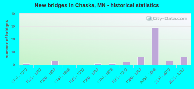
- New bridges - historical statistics
- 11910-1919
- 31930-1939
- 11960-1969
- 11970-1979
- 21980-1989
- 61990-1999
- 292000-2009
- 32010-2019
- 62020-2022
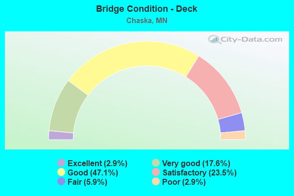
- Bridge Condition - Deck
- 2.9%Excellent
- 17.6%Very good
- 47.1%Good
- 23.5%Satisfactory
- 5.9%Fair
- 2.9%Poor
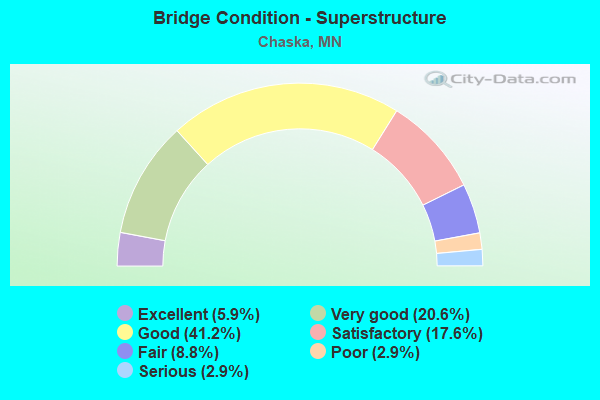
- Bridge Condition - Superstructure
- 5.9%Excellent
- 20.6%Very good
- 41.2%Good
- 17.6%Satisfactory
- 8.8%Fair
- 2.9%Poor
- 2.9%Serious
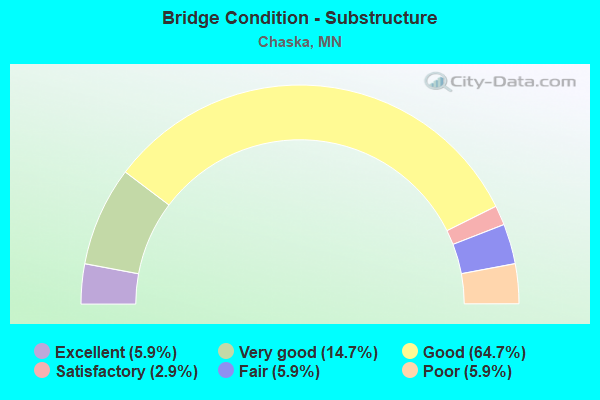
- Bridge Condition - Substructure
- 5.9%Excellent
- 14.7%Very good
- 64.7%Good
- 2.9%Satisfactory
- 5.9%Fair
- 5.9%Poor
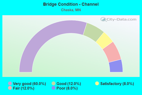
- Bridge Condition - Channel
- 60.0%Very good
- 12.0%Good
- 8.0%Satisfactory
- 12.0%Fair
- 8.0%Poor
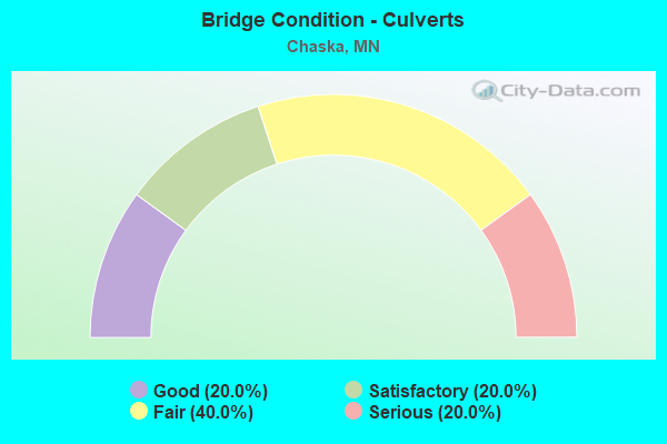
- Bridge Condition - Culverts
- 20.0%Good
- 20.0%Satisfactory
- 40.0%Fair
- 20.0%Serious
Find on map >> Show street view
Structure Number: 10029, Location: 0.8 MI W JT ENGLER;BAV RD (Lat: 44.805856, Lng: -93.625375), Route carried "under" structure: US 212, Year Built: 2007, Structure Length: 0. m, Average Daily Traffic: 28,000 (year 2019), Truck Traffic: 11%, Features Intersected: US 212, Facility Carried by Structure: CSAH 10
Minimum Vertical Clearance: 5.15m (16.90ft), Kilometerpoint: 0.000, Lanes on structure: 4, Lanes under structure: 4, Material/Design: Prestressed concrete, Design/Construction: Stringer/Multi-beam, Length of Maximum Span: 34.8m (114.2ft)
Find on map >> Show street view
Structure Number: 10031, Location: 0.57 MI N CSAH 10; BAV RD (Lat: 44.813606, Lng: -93.612464), Route carried "under" structure: US 212, Year Built: 2007, Structure Length: 0. m, Average Daily Traffic: 28,000 (year 2019), Truck Traffic: 11%, Features Intersected: US 212, Facility Carried by Structure: MSAS 101
Minimum Vertical Clearance: 5.06m (16.60ft), Kilometerpoint: 0.000, Lanes on structure: 2, Lanes under structure: 4, Material/Design: Prestressed concrete, Design/Construction: Stringer/Multi-beam, Length of Maximum Span: 30.5m (100.1ft)
Find on map >> Show street view
Structure Number: 10032, Location: 0.75 MI N JCT CSAH 10 (Lat: 44.815506, Lng: -93.602408), Route carried "under" structure: US 212, Year Built: 2007, Structure Length: 0. m, Average Daily Traffic: 39,924 (year 2019), Truck Traffic: 6%, Features Intersected: US 212, Facility Carried by Structure: MN 41
Minimum Vertical Clearance: 5.00m (16.40ft), Kilometerpoint: 0.000, Lanes on structure: 4, Lanes under structure: 4, Material/Design: Prestressed concrete, Design/Construction: Stringer/Multi-beam, Length of Maximum Span: 34.6m (113.5ft)
Find on map >> Show street view
Structure Number: 10037, Location: 1.0 MI N JCT CSAH 10; 15 (Lat: 44.821031, Lng: -93.575386), Route carried "under" structure: US 212, Year Built: 2007, Structure Length: 0. m, Average Daily Traffic: 39,924 (year 2019), Truck Traffic: 6%, Features Intersected: US 212, Facility Carried by Structure: CSAH 15
Minimum Vertical Clearance: 5.12m (16.80ft), Kilometerpoint: 0.000, Lanes on structure: 2, Lanes under structure: 4, Material/Design: Prestressed concrete, Design/Construction: Stringer/Multi-beam, Length of Maximum Span: 46.0m (150.9ft)
Find on map >> Show street view
Structure Number: 10048, Location: 1.0 MI NE JCT MN41;CSAH10 (Lat: 44.819972, Lng: -93.588097), Route carried "under" structure: US 212, Year Built: 2007, Structure Length: 0. m, Average Daily Traffic: 39,924 (year 2019), Truck Traffic: 6%, Features Intersected: US 212, Facility Carried by Structure: PEDESTRIAN
Minimum Vertical Clearance: 5.36m (17.59ft), Kilometerpoint: 0.000, Lanes on structure: 4, Lanes under structure: 4, Material/Design: Prestressed concrete, Design/Construction: Girder and Floorbeam System, Length of Maximum Span: 31.5m (103.3ft)
Find on map >> Show street view
Structure Number: 1006, Location: 1.5 MI E OF CSAH11;CSAH44 (Lat: 44.791217, Lng: -93.631842), Route carried "under" structure: US 212, Year Built: 2020, Structure Length: 0. m, Average Daily Traffic: 20,600 (year 2019), Truck Traffic: 12%, Features Intersected: US 212, Facility Carried by Structure: PEDESTRIAN
Minimum Vertical Clearance: 5.27m (17.29ft), Kilometerpoint: 0.000, Lanes under structure: 5, Material/Design: Prestressed concrete, Design/Construction: Stringer/Multi-beam, Length of Maximum Span: 32.0m (105.0ft)
Find on map >> Show street view
Structure Number: 70047, Location: AT JCT US 169; TH 41 (Lat: 44.765694, Lng: -93.578508), Route carried "under" structure: State highway 41, Year Built: 2020, Structure Length: 0. m, Average Daily Traffic: 18,467 (year 2019), Truck Traffic: 6%, Features Intersected: TH 41, Facility Carried by Structure: US 169
Minimum Vertical Clearance: 5.40m (17.72ft), Kilometerpoint: 0.000, Lanes under structure: 5, Material/Design: Prestressed concrete, Design/Construction: Stringer/Multi-beam, Length of Maximum Span: 27.7m (90.9ft)
Find on map >> Show street view
Structure Number: 70048, Location: AT JCT US 169; TH 41 (Lat: 44.765658, Lng: -93.578331), Route carried "under" structure: State highway 41, Year Built: 2020, Structure Length: 0. m, Average Daily Traffic: 18,467 (year 2019), Truck Traffic: 6%, Features Intersected: TH 41, Facility Carried by Structure: US 169
Minimum Vertical Clearance: 5.40m (17.72ft), Kilometerpoint: 0.000, Lanes under structure: 5, Material/Design: Prestressed concrete, Design/Construction: Stringer/Multi-beam, Length of Maximum Span: 27.6m (90.6ft)