Bridge Statistics for Chester, Pennsylvania (PA)
Condition, Traffic, Stress, Structural Evaluation, Project Costs
- National Bridge Inventory (NBI) Statistics
- 81Number of bridges
- 2,398ft / 731mTotal length
- $119,042,000Total costs
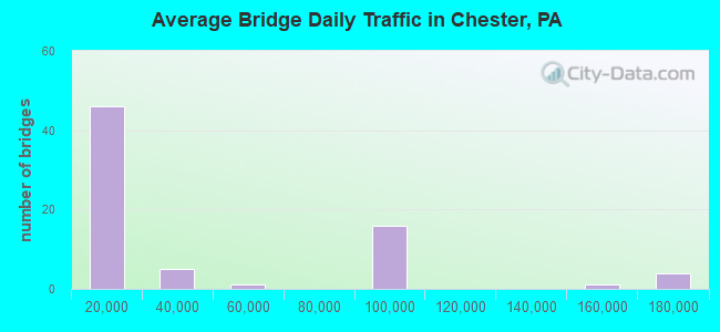
- 2,754,667Total average daily traffic
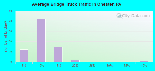
- 176,804Total average daily truck traffic
- National Bridge Inventory (NBI) Registered Bridges for Chester
- No street view available for this location
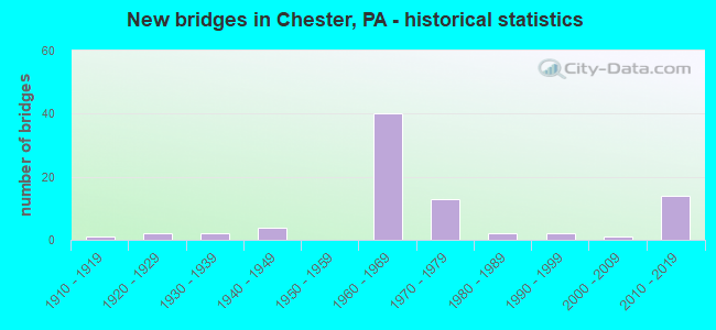
- New bridges - historical statistics
- 11910-1919
- 21920-1929
- 21930-1939
- 41940-1949
- 401960-1969
- 131970-1979
- 21980-1989
- 21990-1999
- 12000-2009
- 142010-2019
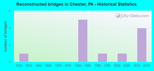
- Reconstructed bridges - Historical Statistics
- 11950-1959
- 01960-1969
- 01970-1979
- 51980-1989
- 11990-1999
- 12000-2009
- 42010-2019
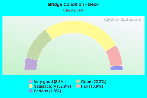
- Bridge Condition - Deck
- 8.3%Very good
- 22.2%Good
- 52.8%Satisfactory
- 13.9%Fair
- 2.8%Serious

- Bridge Condition - Superstructure
- 10.3%Very good
- 38.5%Good
- 25.6%Satisfactory
- 20.5%Fair
- 2.6%Poor
- 2.6%Serious
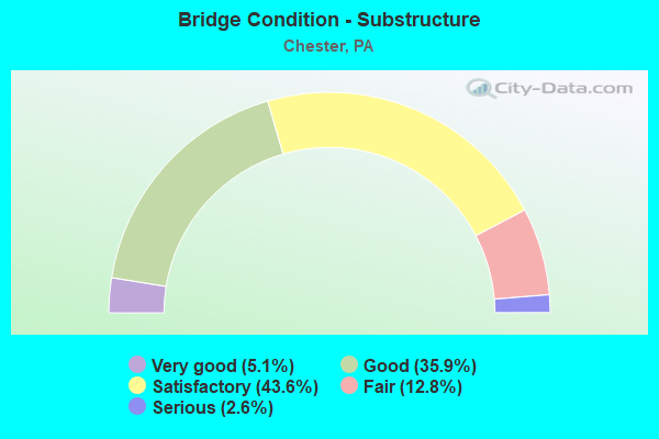
- Bridge Condition - Substructure
- 5.1%Very good
- 35.9%Good
- 43.6%Satisfactory
- 12.8%Fair
- 2.6%Serious
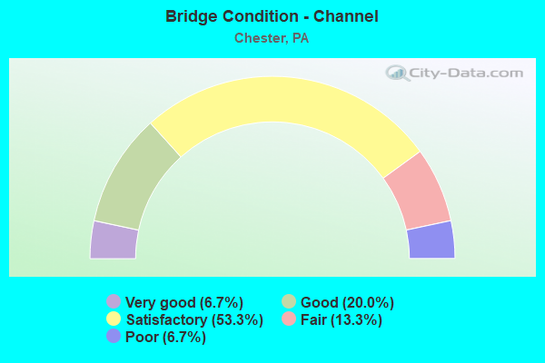
- Bridge Condition - Channel
- 6.7%Very good
- 20.0%Good
- 53.3%Satisfactory
- 13.3%Fair
- 6.7%Poor
Find on map >> Show street view
Structure Number: 49032, Location: EDGMONT AVE. RAMP 3807C3 (Lat: 39.856947, Lng: -75.361489), Route carried "on" structure: Ramp State highway , Year Built: 2004, Status: Open, Structure Length: 1.46m (4.79ft), Average Daily Traffic: 5,198 (year 2021), Truck Traffic: 5%, Average Future Daily Traffic: 4,903 (year 2032), Design Load: HS 25 or greater, Features Intersected: OPEN GROUND, Facility Carried by Structure: RAMP D (SR 8021)
Minimum Vertical Clearance: 30+ m (98+ ft), Kilometerpoint: 0.000, Lanes on structure: 1, Base Highway Network: Yes, Owner: State Highway Agency, Approaching Roadway Width: 5.8m (19.0ft), Material/Design: Steel, Design/Construction: Stringer/Multi-beam, Number Of Spans In Main Unit: 1, Length of Maximum Span: 14.3m (46.9ft), Curb-To-Curb Width: 5.8m (19.0ft), Out-to-Out Width: 7.0m (23.0ft)
Condition: Deck: Good, Superstructure: Very good, Substructure: Good, Inventory Rating: 61.7 metric tons, Method Used To Determine Inventory Rating: Load Factor (LF), Structural Evaluation: Better than present minimum criteria, Deck Geometry: Meets minimum limits, Approach Roadway Alignment: Better than present minimum criteria, Designated Inspection Frequency: Every 24 months, Critical Feature Inspection Frequency: Every 24 months, Inspection Date: August 2021, Critical Feature Inspection Date: August 2021, Deck Structure Type: Concrete Cast-file-Place, Wearing Surface/Protective System: Wearing Surface: Monolithic Concrete, Deck Protection: Epoxy Coated Reinforcing
Find on map >> Show street view
Structure Number: 54893, Location: W OF SPROUL ST 3807-B5 (Lat: 39.848697, Lng: -75.362597), Route carried "on" structure: City street 10, Year Built: 1963, Status: Closed, Structure Length: 3.66m (12.01ft), Average Daily Traffic: 1,000 (year 2018), Truck Traffic: 3%, Average Future Daily Traffic: 1,500 (year 2038), Design Load: HS 20, Features Intersected: CHESTER CREEK, Facility Carried by Structure: SIXTH ST
Minimum Vertical Clearance: 30+ m (98+ ft), Kilometerpoint: 0.000, Lanes on structure: 2, Owner: Town or Township Highway Agency, Approaching Roadway Width: 9.1m (29.9ft), Material/Design: Steel, Design/Construction: Stringer/Multi-beam, Number Of Spans In Main Unit: 1, Length of Maximum Span: 36.3m (119.1ft), Curb or Sidewalk Widths: Left: 2.5m (8.2ft), Right: 1.1m (3.6ft), Curb-To-Curb Width: 9.2m (30.2ft), Out-to-Out Width: 13.5m (44.3ft)
Condition: Deck: Fair, Superstructure: Serious, Substructure: Fair, Channel: Satisfactory, Operating Rating: 39.9 metric tons, Method Used To Determine Operating Rating: Load Factor (LF), Inventory Rating: 23.6 metric tons, Method Used To Determine Inventory Rating: Load Factor (LF), Structural Evaluation: High priority of corrective action, Deck Geometry: Meets minimum limits, Waterway Adequacy: Equal to present desirable criteria, Approach Roadway Alignment: Equal to present desirable criteria, Designated Inspection Frequency: Every 24 months, Inspection Date: August 2020, Deck Structure Type: Concrete Cast-file-Place, Wearing Surface/Protective System: Wearing Surface: Bituminous
Find on map >> Show street view
Structure Number: 14875, Location: US322 RAMP 42K06 (Lat: 39.839983, Lng: -75.406239), Route carried "under" structure: Ramp State highway , Year Built: 1966, Structure Length: 0. m, Average Daily Traffic: 1,390 (year 2021), Truck Traffic: 7%, Features Intersected: RAMP A TO HIGHLAND AVE., Facility Carried by Structure: INTERSTATE 95(NB)
Minimum Vertical Clearance: 4.52m (14.83ft), Kilometerpoint: 0.000, Lanes on structure: 3, Lanes under structure: 1, Material/Design: Prestressed concrete, Design/Construction: Box Beam or Girders - Multiple, Length of Maximum Span: 10.4m (34.1ft)
Find on map >> Show street view
Structure Number: 14878, Location: US 322 INTERCHANGE 42K06 (Lat: 39.840872, Lng: -75.406992), Route carried "under" structure: US 322, Year Built: 1967, Structure Length: 0. m, Average Daily Traffic: 19,497 (year 2022), Truck Traffic: 6%, Features Intersected: US 322 EB & RAMP A, Facility Carried by Structure: INTERSTATE 95(SB)
Minimum Vertical Clearance: 4.72m (15.49ft), Kilometerpoint: 10.800, Lanes on structure: 3, Lanes under structure: 1, Material/Design: Steel, Design/Construction: Stringer/Multi-beam, Length of Maximum Span: 34.1m (111.9ft)
Find on map >> Show street view
Structure Number: 14878, Location: US 322 INTERCHANGE 42K06 (Lat: 39.840872, Lng: -75.406992), Route carried "under" structure: Ramp State highway , Year Built: 1967, Structure Length: 0. m, Average Daily Traffic: 1,370 (year 2010), Truck Traffic: 7%, Features Intersected: US 322 EB & RAMP A, Facility Carried by Structure: INTERSTATE 95(SB)
Minimum Vertical Clearance: 5.36m (17.59ft), Kilometerpoint: 0.000, Lanes on structure: 3, Lanes under structure: 3, Material/Design: Steel, Design/Construction: Stringer/Multi-beam, Length of Maximum Span: 34.1m (111.9ft)
Find on map >> Show street view
Structure Number: 14881, Location: .3MI.N.OF US-322 43A06 (Lat: 39.841633, Lng: -75.401883), Route carried "under" structure: Interstate 95, Year Built: 1967, Structure Length: 0. m, Average Daily Traffic: 96,776 (year 2022), Truck Traffic: 6%, Features Intersected: INTERSTATE 95, Facility Carried by Structure: HIGHLAND AV.RELOC.
Minimum Vertical Clearance: 5.03m (16.50ft), Kilometerpoint: 4.807, Lanes on structure: 2, Lanes under structure: 3, Material/Design: Prestressed concrete, Design/Construction: Box Beam or Girders - Single/Spread, Length of Maximum Span: 25.0m (82.0ft)
Find on map >> Show street view
Structure Number: 14881, Location: .3MI.N.OF US-322 43A06 (Lat: 39.841633, Lng: -75.401883), Route carried "under" structure: Interstate 95, Year Built: 1967, Structure Length: 0. m, Average Daily Traffic: 85,010 (year 2022), Truck Traffic: 6%, Features Intersected: INTERSTATE 95, Facility Carried by Structure: HIGHLAND AV.RELOC.
Minimum Vertical Clearance: 5.59m (18.34ft), Kilometerpoint: 4.831, Lanes on structure: 2, Lanes under structure: 3, Material/Design: Prestressed concrete, Design/Construction: Box Beam or Girders - Single/Spread, Length of Maximum Span: 25.0m (82.0ft)
Find on map >> Show street view
Structure Number: 14886, Location: BARRY BRIDGE RAMPS 43C05 (Lat: 39.847033, Lng: -75.387472), Route carried "under" structure: State highway , Year Built: 1977, Structure Length: 0. m, Average Daily Traffic: 20,550 (year 2021), Truck Traffic: 10%, Features Intersected: RAMP E &RAMP F TO BARRY, Facility Carried by Structure: INTERSTATE 95
Minimum Vertical Clearance: 4.70m (15.42ft), Kilometerpoint: 0.000, Lanes on structure: 3, Lanes under structure: 1, Material/Design: Steel, Design/Construction: Stringer/Multi-beam, Length of Maximum Span: 48.2m (158.1ft)
Find on map >> Show street view
Structure Number: 14886, Location: BARRY BRIDGE RAMPS 43C05 (Lat: 39.847033, Lng: -75.387472), Route carried "under" structure: US 322, Year Built: 1977, Structure Length: 0. m, Average Daily Traffic: 10,378 (year 2021), Truck Traffic: 14%, Features Intersected: RAMP E &RAMP F TO BARRY, Facility Carried by Structure: INTERSTATE 95
Minimum Vertical Clearance: 9.14m (29.99ft), Kilometerpoint: 0.000, Lanes on structure: 3, Lanes under structure: 1, Material/Design: Steel, Design/Construction: Stringer/Multi-beam, Length of Maximum Span: 48.2m (158.1ft)
Find on map >> Show street view
Structure Number: 14892, Location: CITY OF CHESTER 43E04 (Lat: 39.851764, Lng: -75.373750), Route carried "under" structure: State highway , Year Built: 1964, Structure Length: 0. m, Average Daily Traffic: 17,534 (year 2022), Truck Traffic: 2%, Features Intersected: KERLIN STREET, Facility Carried by Structure: INTERSTATE 95
Minimum Vertical Clearance: 4.29m (14.07ft), Kilometerpoint: 0.000, Lanes on structure: 3, Lanes under structure: 2, Material/Design: Prestressed concrete, Design/Construction: Box Beam or Girders - Single/Spread, Length of Maximum Span: 18.9m (62.0ft)
Find on map >> Show street view
Structure Number: 14899, Location: OVER RIDLEY CREEK 43J02 (Lat: 39.863872, Lng: -75.348878), Route carried "under" structure: State highway , Year Built: 1965, Structure Length: 0. m, Average Daily Traffic: 600 (year 1980), Truck Traffic: 7%, Features Intersected: RIDLEY CREEK & SUN DRIVE, Facility Carried by Structure: INTERSTATE 95
Minimum Vertical Clearance: 4.27m (14.01ft), Kilometerpoint: 0.000, Lanes on structure: 3, Lanes under structure: 2, Material/Design: Prestressed concrete, Design/Construction: Stringer/Multi-beam, Length of Maximum Span: 28.7m (94.2ft)
Find on map >> Show street view
Structure Number: 14964, Location: .7MI.S. RIDLEY CK. 43G03 (Lat: 39.857069, Lng: -75.360775), Route carried "under" structure: Interstate 95, Year Built: 1968, Structure Length: 0. m, Average Daily Traffic: 98,656 (year 2022), Truck Traffic: 6%, Features Intersected: CSX & INTERSTATE 95, Facility Carried by Structure: MADISON STREET(NB)
Minimum Vertical Clearance: 5.31m (17.42ft), Kilometerpoint: 8.097, Lanes on structure: 2, Lanes under structure: 3, Material/Design: Steel, Design/Construction: Stringer/Multi-beam, Length of Maximum Span: 32.0m (105.0ft)
Find on map >> Show street view
Structure Number: 14964, Location: .7MI.S. RIDLEY CK. 43G03 (Lat: 39.857069, Lng: -75.360775), Route carried "under" structure: Interstate 95, Year Built: 1968, Structure Length: 0. m, Average Daily Traffic: 80,639 (year 2022), Truck Traffic: 7%, Features Intersected: CSX & INTERSTATE 95, Facility Carried by Structure: MADISON STREET(NB)
Minimum Vertical Clearance: 5.18m (16.99ft), Kilometerpoint: 8.053, Lanes on structure: 2, Lanes under structure: 3, Material/Design: Steel, Design/Construction: Stringer/Multi-beam, Length of Maximum Span: 32.0m (105.0ft)
Find on map >> Show street view
Structure Number: 14988, Location: 1MILE WEST OF I-95 42J06 (Lat: 39.843439, Lng: -75.415894), Route carried "under" structure: Alternate State highway , Year Built: 1949, Structure Length: 0. m, Average Daily Traffic: 772 (year 2022), Truck Traffic: 7%, Features Intersected: CSX RAILROAD, Facility Carried by Structure: CONCHESTER HIGHWAY
Minimum Vertical Clearance: 30+ m (98+ ft), Kilometerpoint: 0.000, Lanes on structure: 2, Lanes under structure: 1, Material/Design: Steel continuous, Design/Construction: Girder and Floorbeam System, Length of Maximum Span: 33.5m (109.9ft)
Find on map >> Show street view
Structure Number: 14988, Location: 1MILE WEST OF I-95 42J06 (Lat: 39.843439, Lng: -75.415894), Route carried "under" structure: Alternate State highway , Year Built: 1949, Structure Length: 0. m, Average Daily Traffic: 1,348 (year 2022), Truck Traffic: 36%, Features Intersected: CSX RAILROAD, Facility Carried by Structure: CONCHESTER HIGHWAY
Minimum Vertical Clearance: 30+ m (98+ ft), Kilometerpoint: 0.000, Lanes on structure: 2, Lanes under structure: 1, Material/Design: Steel continuous, Design/Construction: Girder and Floorbeam System, Length of Maximum Span: 33.5m (109.9ft)
Find on map >> Show street view
Structure Number: 14989, Location: .8MI.S.RIDLEY CK. 43G03 (Lat: 39.856947, Lng: -75.361150), Route carried "under" structure: Interstate 95, Year Built: 1967, Structure Length: 0. m, Average Daily Traffic: 98,656 (year 2022), Truck Traffic: 6%, Features Intersected: INTERSTATE 95;CSX RAILRO, Facility Carried by Structure: EDGMONT AVENUE
Minimum Vertical Clearance: 5.15m (16.90ft), Kilometerpoint: 8.097, Lanes on structure: 2, Lanes under structure: 3, Material/Design: Steel, Design/Construction: Stringer/Multi-beam, Length of Maximum Span: 32.0m (105.0ft)
Find on map >> Show street view
Structure Number: 14989, Location: .8MI.S.RIDLEY CK. 43G03 (Lat: 39.856947, Lng: -75.361150), Route carried "under" structure: Interstate 95, Year Built: 1967, Structure Length: 0. m, Average Daily Traffic: 80,639 (year 2022), Truck Traffic: 7%, Features Intersected: INTERSTATE 95;CSX RAILRO, Facility Carried by Structure: EDGMONT AVENUE
Minimum Vertical Clearance: 5.16m (16.93ft), Kilometerpoint: 8.053, Lanes on structure: 2, Lanes under structure: 3, Material/Design: Steel, Design/Construction: Stringer/Multi-beam, Length of Maximum Span: 32.0m (105.0ft)
Find on map >> Show street view
Structure Number: 15445, Location: 400FEET N.PA320 3807-C3 (Lat: 39.857631, Lng: -75.359458), Route carried "under" structure: Interstate 95, Year Built: 1963, Structure Length: 0. m, Average Daily Traffic: 80,639 (year 2022), Truck Traffic: 7%, Features Intersected: INTERSTATE 95;CSX R.R., Facility Carried by Structure: UPLAND STREET
Minimum Vertical Clearance: 5.00m (16.40ft), Kilometerpoint: 8.879, Lanes on structure: 1, Lanes under structure: 6, Material/Design: Steel, Design/Construction: Stringer/Multi-beam, Length of Maximum Span: 30.8m (101.0ft)
Find on map >> Show street view
Structure Number: 15445, Location: 400FEET N.PA320 3807-C3 (Lat: 39.857631, Lng: -75.359458), Route carried "under" structure: Interstate 95, Year Built: 1963, Structure Length: 0. m, Average Daily Traffic: 98,656 (year 2022), Truck Traffic: 6%, Features Intersected: INTERSTATE 95;CSX R.R., Facility Carried by Structure: UPLAND STREET
Minimum Vertical Clearance: 5.03m (16.50ft), Kilometerpoint: 8.919, Lanes on structure: 1, Lanes under structure: 6, Material/Design: Steel, Design/Construction: Stringer/Multi-beam, Length of Maximum Span: 30.8m (101.0ft)
Find on map >> Show street view
Structure Number: 15446, Location: 900' N of PA-320 3807-C3 (Lat: 39.858178, Lng: -75.358039), Route carried "under" structure: Interstate 95, Year Built: 1963, Structure Length: 0. m, Average Daily Traffic: 80,639 (year 2022), Truck Traffic: 7%, Features Intersected: INTERSTATE 95; CSX R.R., Facility Carried by Structure: POTTER STREET
Minimum Vertical Clearance: 5.08m (16.67ft), Kilometerpoint: 8.879, Lanes on structure: 1, Lanes under structure: 3, Material/Design: Steel, Design/Construction: Stringer/Multi-beam, Length of Maximum Span: 30.8m (101.0ft)
Find on map >> Show street view
Structure Number: 15446, Location: 900' N of PA-320 3807-C3 (Lat: 39.858178, Lng: -75.358039), Route carried "under" structure: Interstate 95, Year Built: 1963, Structure Length: 0. m, Average Daily Traffic: 98,656 (year 2022), Truck Traffic: 6%, Features Intersected: INTERSTATE 95; CSX R.R., Facility Carried by Structure: POTTER STREET
Minimum Vertical Clearance: 5.51m (18.08ft), Kilometerpoint: 8.919, Lanes on structure: 1, Lanes under structure: 3, Material/Design: Steel, Design/Construction: Stringer/Multi-beam, Length of Maximum Span: 30.8m (101.0ft)
Find on map >> Show street view
Structure Number: 15448, Location: .3 Mi N of PA-320 3807-D3 (Lat: 39.859436, Lng: -75.355672), Route carried "under" structure: Interstate 95, Year Built: 1966, Structure Length: 0. m, Average Daily Traffic: 98,656 (year 2022), Truck Traffic: 6%, Features Intersected: INTERSTATE 95; CSX R.R., Facility Carried by Structure: CHESTNUT STREET
Minimum Vertical Clearance: 5.46m (17.91ft), Kilometerpoint: 8.919, Lanes on structure: 2, Lanes under structure: 6, Material/Design: Steel, Design/Construction: Stringer/Multi-beam, Length of Maximum Span: 30.2m (99.1ft)
Find on map >> Show street view
Structure Number: 15448, Location: .3 Mi N of PA-320 3807-D3 (Lat: 39.859436, Lng: -75.355672), Route carried "under" structure: Interstate 95, Year Built: 1966, Structure Length: 0. m, Average Daily Traffic: 80,639 (year 2022), Truck Traffic: 7%, Features Intersected: INTERSTATE 95; CSX R.R., Facility Carried by Structure: CHESTNUT STREET
Minimum Vertical Clearance: 5.33m (17.49ft), Kilometerpoint: 8.879, Lanes on structure: 2, Lanes under structure: 6, Material/Design: Steel, Design/Construction: Stringer/Multi-beam, Length of Maximum Span: 30.2m (99.1ft)
Find on map >> Show street view
Structure Number: 15449, Location: .5 Mi N of PA-320 3807-D3 (Lat: 39.860661, Lng: -75.353383), Route carried "under" structure: Ramp State highway , Year Built: 1963, Structure Length: 0. m, Average Daily Traffic: 3,522 (year 2021), Truck Traffic: 5%, Features Intersected: I-95; RAMPS; & CSX R.R., Facility Carried by Structure: MELROSE AVENUE
Minimum Vertical Clearance: 5.31m (17.42ft), Kilometerpoint: 0.000, Lanes on structure: 2, Lanes under structure: 8, Material/Design: Steel continuous, Design/Construction: Stringer/Multi-beam, Length of Maximum Span: 31.4m (103.0ft)
Find on map >> Show street view
Structure Number: 15449, Location: .5 Mi N of PA-320 3807-D3 (Lat: 39.860661, Lng: -75.353383), Route carried "under" structure: Interstate 95, Year Built: 1963, Structure Length: 0. m, Average Daily Traffic: 98,656 (year 2022), Truck Traffic: 6%, Features Intersected: I-95; RAMPS; & CSX R.R., Facility Carried by Structure: MELROSE AVENUE
Minimum Vertical Clearance: 6.04m (19.82ft), Kilometerpoint: 8.919, Lanes on structure: 2, Lanes under structure: 8, Material/Design: Steel continuous, Design/Construction: Stringer/Multi-beam, Length of Maximum Span: 31.4m (103.0ft)
Find on map >> Show street view
Structure Number: 15449, Location: .5 Mi N of PA-320 3807-D3 (Lat: 39.860661, Lng: -75.353383), Route carried "under" structure: Interstate 95, Year Built: 1963, Structure Length: 0. m, Average Daily Traffic: 80,639 (year 2022), Truck Traffic: 7%, Features Intersected: I-95; RAMPS; & CSX R.R., Facility Carried by Structure: MELROSE AVENUE
Minimum Vertical Clearance: 4.97m (16.31ft), Kilometerpoint: 8.879, Lanes on structure: 2, Lanes under structure: 8, Material/Design: Steel continuous, Design/Construction: Stringer/Multi-beam, Length of Maximum Span: 31.4m (103.0ft)
Find on map >> Show street view
Structure Number: 15449, Location: .5 Mi N of PA-320 3807-D3 (Lat: 39.860661, Lng: -75.353383), Route carried "under" structure: Ramp State highway , Year Built: 1963, Structure Length: 0. m, Average Daily Traffic: 4,382 (year 2022), Truck Traffic: 5%, Features Intersected: I-95; RAMPS; & CSX R.R., Facility Carried by Structure: MELROSE AVENUE
Minimum Vertical Clearance: 6.07m (19.91ft), Kilometerpoint: 0.000, Lanes on structure: 2, Lanes under structure: 8, Material/Design: Steel continuous, Design/Construction: Stringer/Multi-beam, Length of Maximum Span: 31.4m (103.0ft)
Find on map >> Show street view
Structure Number: 1545, Location: RAMP B COMM BARRY 43D06 (Lat: 39.840000, Lng: -75.383333), Route carried "under" structure: City street , Year Built: 1974, Structure Length: 0. m, Features Intersected: SEVENTH STREET, Facility Carried by Structure: RAMP B COMM BARRY
Minimum Vertical Clearance: 7.68m (25.20ft), Kilometerpoint: 0.000, Lanes on structure: 1, Lanes under structure: 2, Toll: Toll bridge, Material/Design: Steel, Design/Construction: Stringer/Multi-beam, Length of Maximum Span: 32.6m (107.0ft)
Find on map >> Show street view
Structure Number: 15451, Location: RAMP A COM BARRY 43D06 (Lat: 39.840508, Lng: -75.383172), Route carried "under" structure: City street , Year Built: 1974, Structure Length: 0. m, Features Intersected: SEVENTH ST;FLOWER STREET, Facility Carried by Structure: RAMP A COMM BARRY
Minimum Vertical Clearance: 7.67m (25.16ft), Kilometerpoint: 0.000, Lanes on structure: 1, Lanes under structure: 4, Toll: Toll bridge, Material/Design: Steel, Design/Construction: Stringer/Multi-beam, Length of Maximum Span: 32.6m (107.0ft)
Find on map >> Show street view
Structure Number: 15451, Location: RAMP A COM BARRY 43D06 (Lat: 39.840508, Lng: -75.383172), Route carried "under" structure: City street , Year Built: 1974, Structure Length: 0. m, Features Intersected: SEVENTH ST;FLOWER STREET, Facility Carried by Structure: RAMP A COMM BARRY
Minimum Vertical Clearance: 4.90m (16.08ft), Kilometerpoint: 0.000, Lanes on structure: 1, Lanes under structure: 4, Toll: Toll bridge, Material/Design: Steel, Design/Construction: Stringer/Multi-beam, Length of Maximum Span: 32.6m (107.0ft)
Find on map >> Show street view
Structure Number: 15452, Location: 2 MILES WEST OF US 130 (Lat: 39.842311, Lng: -75.384931), Route carried "under" structure: ServiceOther road , Year Built: 1974, Structure Length: 0. m, Average Daily Traffic: 312 (year 2012), Truck Traffic: 1%, Features Intersected: DELAWARE RIVER, Facility Carried by Structure: US 322
Minimum Vertical Clearance: 4.46m (14.63ft), Kilometerpoint: 0.000, Lanes on structure: 5, Lanes under structure: 2, Material/Design: Steel, Design/Construction: Truss - Thru, Length of Maximum Span: 501.1m (1,644.0ft)
Find on map >> Show street view
Structure Number: 15468, Location: HIGHLAND AVE.INTER.42K06 (Lat: 39.840156, Lng: -75.408619), Route carried "under" structure: Ramp State highway , Year Built: 1968, Structure Length: 0. m, Average Daily Traffic: 1,370 (year 2010), Truck Traffic: 7%, Features Intersected: LR 180:EB, WB, RAMP A, Facility Carried by Structure: RAMP N SOUTHBOUND
Minimum Vertical Clearance: 7.60m (24.93ft), Kilometerpoint: 0.000, Lanes on structure: 1, Lanes under structure: 1, Material/Design: Prestressed concrete, Design/Construction: Box Beam or Girders - Single/Spread, Length of Maximum Span: 21.0m (68.9ft)
Find on map >> Show street view
Structure Number: 15468, Location: HIGHLAND AVE.INTER.42K06 (Lat: 39.840156, Lng: -75.408619), Route carried "under" structure: US 322, Year Built: 1968, Structure Length: 0. m, Average Daily Traffic: 9,848 (year 2020), Truck Traffic: 17%, Features Intersected: LR 180:EB, WB, RAMP A, Facility Carried by Structure: RAMP N SOUTHBOUND
Minimum Vertical Clearance: 4.37m (14.34ft), Kilometerpoint: 10.789, Lanes on structure: 1, Lanes under structure: 2, Material/Design: Prestressed concrete, Design/Construction: Box Beam or Girders - Single/Spread, Length of Maximum Span: 21.0m (68.9ft)
Find on map >> Show street view
Structure Number: 15468, Location: HIGHLAND AVE.INTER.42K06 (Lat: 39.840156, Lng: -75.408619), Route carried "under" structure: US 322, Year Built: 1968, Structure Length: 0. m, Average Daily Traffic: 19,497 (year 2022), Truck Traffic: 6%, Features Intersected: LR 180:EB, WB, RAMP A, Facility Carried by Structure: RAMP N SOUTHBOUND
Minimum Vertical Clearance: 7.77m (25.49ft), Kilometerpoint: 10.800, Lanes on structure: 1, Lanes under structure: 3, Material/Design: Prestressed concrete, Design/Construction: Box Beam or Girders - Single/Spread, Length of Maximum Span: 21.0m (68.9ft)
Find on map >> Show street view
Structure Number: 15473, Location: FLOWER ST.INTERCH. 43C05 (Lat: 39.846667, Lng: -75.390000), Route carried "under" structure: Ramp US 322, Year Built: 1976, Structure Length: 0. m, Average Daily Traffic: 10,378 (year 2021), Truck Traffic: 14%, Features Intersected: RAMP E TO S.B.I-95, Facility Carried by Structure: RAMP F S.B. TO BAR
Minimum Vertical Clearance: 4.57m (14.99ft), Kilometerpoint: 0.000, Lanes on structure: 2, Lanes under structure: 1, Material/Design: Steel, Design/Construction: Stringer/Multi-beam, Length of Maximum Span: 34.7m (113.8ft)
Find on map >> Show street view
Structure Number: 45384, Location: COMM. BARRY BRDG 3806K07 (Lat: 39.833614, Lng: -75.380406), Route carried "under" structure: City street , Year Built: 2011, Structure Length: 0. m, Features Intersected: 2nd ST,FRONT & REANEY ST, Facility Carried by Structure: RAMP A
Minimum Vertical Clearance: 19.20m (62.99ft), Kilometerpoint: 0.000, Lanes on structure: 1, Lanes under structure: 2, Material/Design: Steel continuous, Design/Construction: Stringer/Multi-beam, Length of Maximum Span: 59.4m (194.9ft)
Find on map >> Show street view
Structure Number: 45384, Location: COMM. BARRY BRDG 3806K07 (Lat: 39.833614, Lng: -75.380406), Route carried "under" structure: City street , Year Built: 2011, Structure Length: 0. m, Features Intersected: 2nd ST,FRONT & REANEY ST, Facility Carried by Structure: RAMP A
Minimum Vertical Clearance: 21.34m (70.01ft), Kilometerpoint: 0.000, Lanes on structure: 1, Lanes under structure: 2, Material/Design: Steel continuous, Design/Construction: Stringer/Multi-beam, Length of Maximum Span: 59.4m (194.9ft)
Find on map >> Show street view
Structure Number: 45384, Location: COMM. BARRY BRDG 3806K07 (Lat: 39.833614, Lng: -75.380406), Route carried "under" structure: State highway 291, Year Built: 2011, Structure Length: 0. m, Average Daily Traffic: 1,778 (year 2020), Truck Traffic: 11%, Features Intersected: 2nd ST,FRONT & REANEY ST, Facility Carried by Structure: RAMP A
Minimum Vertical Clearance: 23.47m (77.00ft), Kilometerpoint: 2.044, Lanes on structure: 1, Lanes under structure: 2, Material/Design: Steel continuous, Design/Construction: Stringer/Multi-beam, Length of Maximum Span: 59.4m (194.9ft)
Find on map >> Show street view
Structure Number: 45384, Location: COMM. BARRY BRDG 3806K07 (Lat: 39.833614, Lng: -75.380406), Route carried "under" structure: State highway 291, Year Built: 2011, Structure Length: 0. m, Average Daily Traffic: 1,778 (year 2020), Truck Traffic: 11%, Features Intersected: 2nd ST,FRONT & REANEY ST, Facility Carried by Structure: RAMP A
Minimum Vertical Clearance: 23.47m (77.00ft), Kilometerpoint: 2.042, Lanes on structure: 1, Lanes under structure: 2, Material/Design: Steel continuous, Design/Construction: Stringer/Multi-beam, Length of Maximum Span: 59.4m (194.9ft)
Find on map >> Show street view
Structure Number: 45385, Location: COMMODORE BARRY BRIDGE (Lat: 39.835936, Lng: -75.376153), Route carried "under" structure: City street , Year Built: 2011, Structure Length: 0. m, Features Intersected: US 291; LOCAL ROAD, Facility Carried by Structure: RAMP B
Minimum Vertical Clearance: 17.15m (56.27ft), Kilometerpoint: 0.000, Lanes on structure: 1, Lanes under structure: 2, Material/Design: Steel continuous, Design/Construction: Stringer/Multi-beam, Length of Maximum Span: 58.5m (191.9ft)
Find on map >> Show street view
Structure Number: 45385, Location: COMMODORE BARRY BRIDGE (Lat: 39.835936, Lng: -75.376153), Route carried "under" structure: State highway 291, Year Built: 2011, Structure Length: 0. m, Average Daily Traffic: 1,778 (year 2020), Truck Traffic: 11%, Features Intersected: US 291; LOCAL ROAD, Facility Carried by Structure: RAMP B
Minimum Vertical Clearance: 21.95m (72.01ft), Kilometerpoint: 2.044, Lanes on structure: 1, Lanes under structure: 2, Material/Design: Steel continuous, Design/Construction: Stringer/Multi-beam, Length of Maximum Span: 58.5m (191.9ft)
Find on map >> Show street view
Structure Number: 45385, Location: COMMODORE BARRY BRIDGE (Lat: 39.835936, Lng: -75.376153), Route carried "under" structure: City street , Year Built: 2011, Structure Length: 0. m, Features Intersected: US 291; LOCAL ROAD, Facility Carried by Structure: RAMP B
Minimum Vertical Clearance: 14.02m (46.00ft), Kilometerpoint: 0.000, Lanes on structure: 1, Lanes under structure: 2, Material/Design: Steel continuous, Design/Construction: Stringer/Multi-beam, Length of Maximum Span: 58.5m (191.9ft)
Find on map >> Show street view
Structure Number: 45385, Location: COMMODORE BARRY BRIDGE (Lat: 39.835936, Lng: -75.376153), Route carried "under" structure: City street , Year Built: 2011, Structure Length: 0. m, Features Intersected: US 291; LOCAL ROAD, Facility Carried by Structure: RAMP B
Minimum Vertical Clearance: 5.18m (16.99ft), Kilometerpoint: 0.000, Lanes on structure: 1, Lanes under structure: 2, Material/Design: Steel continuous, Design/Construction: Stringer/Multi-beam, Length of Maximum Span: 58.5m (191.9ft)
Find on map >> Show street view
Structure Number: 45385, Location: COMMODORE BARRY BRIDGE (Lat: 39.835936, Lng: -75.376153), Route carried "under" structure: State highway 291, Year Built: 2011, Structure Length: 0. m, Average Daily Traffic: 1,778 (year 2020), Truck Traffic: 11%, Features Intersected: US 291; LOCAL ROAD, Facility Carried by Structure: RAMP B
Minimum Vertical Clearance: 21.95m (72.01ft), Kilometerpoint: 2.042, Lanes on structure: 1, Lanes under structure: 2, Material/Design: Steel continuous, Design/Construction: Stringer/Multi-beam, Length of Maximum Span: 58.5m (191.9ft)