Bridge Statistics for Chester, Vermont (VT)
Condition, Traffic, Stress, Structural Evaluation, Project Costs
- National Bridge Inventory (NBI) Statistics
- 42Number of bridges
- 279ft / 84.7mTotal length
- $18,883,000Total costs
- 42,414Total average daily traffic
- 3,713Total average daily truck traffic
- 44,542Total future (year 2027) average daily traffic
- National Bridge Inventory (NBI) Registered Bridges for Chester
- No street view available for this location
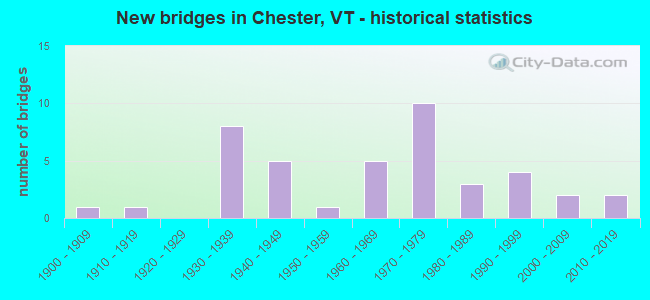
- New bridges - historical statistics
- 11900-1909
- 11910-1919
- 81930-1939
- 51940-1949
- 11950-1959
- 51960-1969
- 101970-1979
- 31980-1989
- 41990-1999
- 22000-2009
- 22010-2019

- Reconstructed bridges - Historical Statistics
- 31960-1969
- 21970-1979
- 11980-1989
- 51990-1999
- 12000-2009
- 12010-2019
- 12020-2022


- Bridge Condition - Deck
- 26.8%Very good
- 31.7%Good
- 31.7%Satisfactory
- 4.9%Fair
- 4.9%Poor

- Bridge Condition - Superstructure
- 31.7%Very good
- 22.0%Good
- 39.0%Satisfactory
- 7.3%Fair

- Bridge Condition - Substructure
- 26.8%Very good
- 41.5%Good
- 26.8%Satisfactory
- 2.4%Fair
- 2.4%Poor

- Bridge Condition - Channel
- 14.3%Very good
- 40.5%Good
- 40.5%Satisfactory
- 4.8%Fair
Find on map >> Show street view
Structure Number: 101407001114071, Location: 0.25 MI TO JCT W VT103 (Lat: 43.275806, Lng: -72.599347), Route carried "on" structure: Other road C2005, Year Built: 1940, Year Reconstructed: 2004, Status: Open, Structure Length: 3.54m (11.61ft), Average Daily Traffic: 530 (year 2019), Truck Traffic: 2%, Average Future Daily Traffic: 557 (year 2029), Design Load: HS 25 or greater, Features Intersected: WILLIAMS RIVER
Minimum Vertical Clearance: 30+ m (98+ ft), Kilometerpoint: 0.000, Lanes on structure: 2, Owner: Town or Township Highway Agency, Approaching Roadway Width: 6.7m (22.0ft), Material/Design: Steel, Design/Construction: Stringer/Multi-beam, Number Of Spans In Main Unit: 2, Length of Maximum Span: 17.4m (57.1ft), Curb or Sidewalk Widths: Left: 0.4m (1.3ft), Right: 0.4m (1.3ft), Curb-To-Curb Width: 6.4m (21.0ft), Out-to-Out Width: 7.2m (23.6ft)
Condition: Deck: Very good, Superstructure: Very good, Substructure: Good, Channel: Good, Operating Rating: 88.0 metric tons, Method Used To Determine Operating Rating: Load Factor (LF), Inventory Rating: 52.6 metric tons, Method Used To Determine Inventory Rating: Load Factor (LF), Structural Evaluation: Better than present minimum criteria, Deck Geometry: High priority of corrective action, Waterway Adequacy: Better than present minimum criteria, Approach Roadway Alignment: Equal to present desirable criteria, Designated Inspection Frequency: Every 24 months, Inspection Date: October 2021, Deck Structure Type: Concrete Cast-file-Place, Wearing Surface/Protective System: Wearing Surface: Bituminous, Membrane: Preformed Fabric, Deck Protection: Epoxy Coated Reinforcing
Find on map >> Show street view
Structure Number: 101407001314071, Location: 0.3 MI TO JCT W VT103 (Lat: 43.239722, Lng: -72.557836), Route carried "on" structure: Other road C2006, Year Built: 2014, Status: Open, Structure Length: 2.80m (9.19ft), Average Daily Traffic: 90 (year 2019), Truck Traffic: 2%, Average Future Daily Traffic: 95 (year 2029), Design Load: HL 93, Features Intersected: WILLIAMS RIVER
Minimum Vertical Clearance: 30+ m (98+ ft), Kilometerpoint: 0.000, Lanes on structure: 1, Owner: Town or Township Highway Agency, Approaching Roadway Width: 4.9m (16.1ft), Material/Design: Steel, Design/Construction: Stringer/Multi-beam, Number Of Spans In Main Unit: 1, Length of Maximum Span: 27.4m (89.9ft), Curb or Sidewalk Widths: Left: 0.2m (0.7ft), Right: 0.2m (0.7ft), Curb-To-Curb Width: 4.1m (13.5ft), Out-to-Out Width: 4.9m (16.1ft)
Condition: Deck: Good, Superstructure: Very good, Substructure: Very good, Channel: Very good, Operating Rating: 63.5 metric tons, Method Used To Determine Operating Rating: Load and Resistance Factor (LRFR), Inventory Rating: 49.0 metric tons, Method Used To Determine Inventory Rating: Load and Resistance Factor (LRFR), Structural Evaluation: Equal to present desirable criteria, Deck Geometry: Somewhat better than minimum adequacy, Waterway Adequacy: Equal to present desirable criteria, Approach Roadway Alignment: Equal to present desirable criteria, Designated Inspection Frequency: Every 24 months, Inspection Date: October 2021, Deck Structure Type: Concrete Cast-file-Place, Wearing Surface/Protective System: Deck Protection: Epoxy Coated Reinforcing
Find on map >> Show street view
Structure Number: 101407002814071, Location: 0.01 MI TO JCT W VT103 (Lat: 43.310917, Lng: -72.605556), Route carried "on" structure: Other road C3077, Year Built: 1949, Year Reconstructed: 1974, Status: Open, Structure Length: 2.13m (6.99ft), Average Daily Traffic: 20 (year 2019), Truck Traffic: 2%, Average Future Daily Traffic: 21 (year 2029), Features Intersected: WILLIAMS RIVER
Minimum Vertical Clearance: 30+ m (98+ ft), Kilometerpoint: 0.000, Lanes on structure: 1, Owner: Town or Township Highway Agency, Approaching Roadway Width: 3.7m (12.1ft), Material/Design: Steel, Design/Construction: Girder and Floorbeam System, Number Of Spans In Main Unit: 1, Length of Maximum Span: 20.4m (66.9ft), Curb-To-Curb Width: 3.7m (12.1ft), Out-to-Out Width: 3.9m (12.8ft)
Condition: Deck: Satisfactory, Superstructure: Satisfactory, Substructure: Satisfactory, Channel: Good, Operating Rating: 22.7 metric tons, Method Used To Determine Operating Rating: Load Factor (LF), Inventory Rating: 13.6 metric tons, Method Used To Determine Inventory Rating: Load Factor (LF), Structural Evaluation: Meets minimum limits, Deck Geometry: Meets minimum limits, Waterway Adequacy: Equal to present minimum criteria, Approach Roadway Alignment: Equal to present minimum criteria, Length Of Structure Improvement: 2.99m (9.81ft), Designated Inspection Frequency: Every 24 months, Critical Feature Inspection Frequency: Every 24 months, Inspection Date: October 2021, Critical Feature Inspection Date: October 2021, Bridge Improvement Cost: $420,000, Roadway Improvement Cost: $150,000, Total Project Cost: $570,000 ( Estimate for 2020), Deck Structure Type: Concrete Cast-file-Place, Wearing Surface/Protective System: Wearing Surface: Bituminous, Membrane: Preformed Fabric
Find on map >> Show street view
Structure Number: 101407004314071, Location: 0.3 MI TO JCT W CL3 TH9 (Lat: 43.331694, Lng: -72.653686), Route carried "on" structure: Other road C3012, Year Built: 1992, Status: Open, Structure Length: 0.76m (2.49ft), Average Daily Traffic: 20 (year 2019), Truck Traffic: 2%, Average Future Daily Traffic: 21 (year 2029), Design Load: H 20, Features Intersected: CHASE BROOK
Minimum Vertical Clearance: 30+ m (98+ ft), Kilometerpoint: 0.000, Lanes on structure: 1, Owner: Town or Township Highway Agency, Approaching Roadway Width: 6.1m (20.0ft), Skew: 1 degrees, Material/Design: Steel, Design/Construction: Stringer/Multi-beam, Number Of Spans In Main Unit: 1, Length of Maximum Span: 7.0m (23.0ft), Curb-To-Curb Width: 4.1m (13.5ft), Out-to-Out Width: 4.2m (13.8ft)
Condition: Deck: Satisfactory, Superstructure: Fair, Substructure: Satisfactory, Channel: Satisfactory, Operating Rating: 28.1 metric tons, Method Used To Determine Operating Rating: Allowable Stress (AS), Inventory Rating: 19.1 metric tons, Method Used To Determine Inventory Rating: Allowable Stress (AS), Structural Evaluation: Somewhat better than minimum adequacy, Deck Geometry: Somewhat better than minimum adequacy, Waterway Adequacy: Equal to present minimum criteria, Approach Roadway Alignment: Equal to present desirable criteria, Length Of Structure Improvement: 1.37m (4.49ft), Designated Inspection Frequency: Every 24 months, Inspection Date: October 2021, Bridge Improvement Cost: $207,000, Roadway Improvement Cost: $150,000, Total Project Cost: $357,000 ( Estimate for 2020), Deck Structure Type: Wood or Timber, Wearing Surface/Protective System: Wearing Surface: Wood or Timber, Deck Protection: Internally Sealed
Find on map >> Show street view
Structure Number: 101407004614071, Location: 0.06 MI TO JCT W C3 TH10 (Lat: 43.228514, Lng: -72.675814), Route carried "on" structure: Other road C3092, Year Built: 1974, Status: Closed, Structure Length: 0.73m (2.40ft), Average Daily Traffic: 10 (year 2019), Truck Traffic: 2%, Average Future Daily Traffic: 11 (year 2029), Design Load: H 10, Features Intersected: SO BR WILLIAMS RIVER
Minimum Vertical Clearance: 30+ m (98+ ft), Kilometerpoint: 0.000, Lanes on structure: 1, Owner: Town or Township Highway Agency, Approaching Roadway Width: 3.7m (12.1ft), Material/Design: Steel, Design/Construction: Stringer/Multi-beam, Number Of Spans In Main Unit: 1, Length of Maximum Span: 6.7m (22.0ft), Curb or Sidewalk Widths: Left: 0.2m (0.7ft), Right: 0.2m (0.7ft), Curb-To-Curb Width: 4.5m (14.8ft), Out-to-Out Width: 4.9m (16.1ft)
Condition: Deck: Good, Superstructure: Good, Substructure: Very good, Channel: Good, Deck Geometry: Equal to present minimum criteria, Approach Roadway Alignment: Equal to present desirable criteria, Bridge Posting: Required (Relationship of Operating Rating to Maximum Legal Load: 0.1 - 9.9% below), Length Of Structure Improvement: 1.31m (4.30ft), Designated Inspection Frequency: Every 24 months, Inspection Date: October 2021, Bridge Improvement Cost: $232,000, Roadway Improvement Cost: $150,000, Total Project Cost: $382,000 ( Estimate for 2020), Deck Structure Type: Wood or Timber, Wearing Surface/Protective System: Wearing Surface: Wood or Timber
Find on map >> Show street view
Structure Number: 101407004914071, Location: 0.05 MI N TO JCT W TH 10 (Lat: 43.232794, Lng: -72.662753), Route carried "on" structure: Other road C3063, Year Built: 2005, Status: Open, Structure Length: 1.37m (4.49ft), Average Daily Traffic: 60 (year 2019), Truck Traffic: 1%, Average Future Daily Traffic: 63 (year 2029), Features Intersected: SO BR WILLIAMS RIVER
Minimum Vertical Clearance: 30+ m (98+ ft), Kilometerpoint: 0.000, Lanes on structure: 1, Owner: Town or Township Highway Agency, Approaching Roadway Width: 4.6m (15.1ft), Skew: 3 degrees, Material/Design: Steel, Design/Construction: Stringer/Multi-beam, Number Of Spans In Main Unit: 1, Length of Maximum Span: 12.5m (41.0ft), Curb-To-Curb Width: 4.6m (15.1ft), Out-to-Out Width: 4.9m (16.1ft)
Condition: Deck: Good, Superstructure: Satisfactory, Substructure: Very good, Channel: Satisfactory, Operating Rating: 22.7 metric tons, Method Used To Determine Operating Rating: Allowable Stress (AS), Inventory Rating: 17.2 metric tons, Method Used To Determine Inventory Rating: Allowable Stress (AS), Structural Evaluation: Somewhat better than minimum adequacy, Deck Geometry: Better than present minimum criteria, Waterway Adequacy: Somewhat better than minimum adequacy, Approach Roadway Alignment: Equal to present desirable criteria, Length Of Structure Improvement: 1.37m (4.49ft), Designated Inspection Frequency: Every 24 months, Inspection Date: October 2021, Bridge Improvement Cost: $252,000, Roadway Improvement Cost: $50,000, Total Project Cost: $302,000 ( Estimate for 2020), Deck Structure Type: Wood or Timber
Find on map >> Show street view
Structure Number: 101407005014071, Location: 0.2 MI TO JCT W CL3 TH9 (Lat: 43.333753, Lng: -72.652328), Route carried "on" structure: Other road C3012, Year Built: 1977, Status: Open, Structure Length: 1.04m (3.41ft), Average Daily Traffic: 20 (year 2019), Truck Traffic: 2%, Average Future Daily Traffic: 21 (year 2029), Design Load: H 20, Features Intersected: CHASE BROOK
Minimum Vertical Clearance: 30+ m (98+ ft), Kilometerpoint: 0.000, Lanes on structure: 2, Owner: Town or Township Highway Agency, Approaching Roadway Width: 6.1m (20.0ft), Skew: 3 degrees, Material/Design: Concrete, Design/Construction: Slab, Number Of Spans In Main Unit: 1, Length of Maximum Span: 9.8m (32.2ft), Curb-To-Curb Width: 4.9m (16.1ft), Out-to-Out Width: 5.3m (17.4ft)
Condition: Deck: Very good, Superstructure: Very good, Substructure: Good, Channel: Satisfactory, Operating Rating: 58.1 metric tons, Method Used To Determine Operating Rating: Load Factor (LF), Inventory Rating: 34.5 metric tons, Method Used To Determine Inventory Rating: Load Factor (LF), Structural Evaluation: Better than present minimum criteria, Deck Geometry: High priority of corrective action, Waterway Adequacy: Equal to present minimum criteria, Approach Roadway Alignment: Better than present minimum criteria, Length Of Structure Improvement: 1.04m (3.41ft), Designated Inspection Frequency: Every 24 months, Inspection Date: October 2021, Bridge Improvement Cost: $208,000, Roadway Improvement Cost: $50,000, Total Project Cost: $258,000 ( Estimate for 2020), Deck Structure Type: Concrete Cast-file-Place
Find on map >> Show street view
Structure Number: 101407005114071, Location: 0.1 MI TO JCT W VT103 (Lat: 43.334925, Lng: -72.615242), Route carried "on" structure: Other road C3019, Year Built: 1974, Status: Open, Structure Length: 1.34m (4.40ft), Average Daily Traffic: 100 (year 2019), Truck Traffic: 2%, Average Future Daily Traffic: 105 (year 2029), Design Load: H 20, Features Intersected: WILLIAMS RIVER
Minimum Vertical Clearance: 30+ m (98+ ft), Kilometerpoint: 0.000, Lanes on structure: 1, Owner: Town or Township Highway Agency, Approaching Roadway Width: 4.9m (16.1ft), Material/Design: Steel, Design/Construction: Stringer/Multi-beam, Number Of Spans In Main Unit: 1, Length of Maximum Span: 12.8m (42.0ft), Curb or Sidewalk Widths: Left: 0.2m (0.7ft), Right: 0.2m (0.7ft), Curb-To-Curb Width: 3.7m (12.1ft), Out-to-Out Width: 4.4m (14.4ft)
Condition: Deck: Very good, Superstructure: Good, Substructure: Good, Channel: Good, Operating Rating: 89.8 metric tons, Method Used To Determine Operating Rating: Load Factor (LF), Inventory Rating: 78.9 metric tons, Method Used To Determine Inventory Rating: Load Factor (LF), Structural Evaluation: Better than present minimum criteria, Deck Geometry: Meets minimum limits, Waterway Adequacy: Equal to present desirable criteria, Approach Roadway Alignment: Better than present minimum criteria, Length Of Structure Improvement: 1.34m (4.40ft), Designated Inspection Frequency: Every 24 months, Inspection Date: October 2021, Bridge Improvement Cost: $220,000, Roadway Improvement Cost: $50,000, Total Project Cost: $270,000 ( Estimate for 2020), Deck Structure Type: Concrete Cast-file-Place
Find on map >> Show street view
Structure Number: 101407005214071, Location: 0.25 MI TO JCT W C3 TH63 (Lat: 43.231519, Lng: -72.667636), Route carried "on" structure: Other road C3010, Year Built: 1939, Status: Open, Structure Length: 0.98m (3.22ft), Average Daily Traffic: 60 (year 2019), Truck Traffic: 2%, Average Future Daily Traffic: 63 (year 2029), Features Intersected: SO BR WILLIAMS RIVER
Minimum Vertical Clearance: 30+ m (98+ ft), Kilometerpoint: 0.000, Lanes on structure: 1, Owner: Town or Township Highway Agency, Approaching Roadway Width: 5.2m (17.1ft), Skew: 2 degrees, Material/Design: Steel, Design/Construction: Stringer/Multi-beam, Number Of Spans In Main Unit: 1, Length of Maximum Span: 8.8m (28.9ft), Curb-To-Curb Width: 4.7m (15.4ft), Out-to-Out Width: 5.3m (17.4ft)
Condition: Deck: Good, Superstructure: Satisfactory, Substructure: Good, Channel: Good, Operating Rating: 65.3 metric tons, Method Used To Determine Operating Rating: Allowable Stress (AS), Inventory Rating: 44.5 metric tons, Method Used To Determine Inventory Rating: Allowable Stress (AS), Structural Evaluation: Equal to present minimum criteria, Deck Geometry: Better than present minimum criteria, Waterway Adequacy: Somewhat better than minimum adequacy, Approach Roadway Alignment: Equal to present desirable criteria, Length Of Structure Improvement: 0.98m (3.22ft), Designated Inspection Frequency: Every 24 months, Inspection Date: October 2021, Bridge Improvement Cost: $194,000, Roadway Improvement Cost: $50,000, Total Project Cost: $244,000 ( Estimate for 2020), Deck Structure Type: Concrete Cast-file-Place
Find on map >> Show street view
Structure Number: 101407005314071, Location: 0.01 MI TO JCT W VT103 (Lat: 43.294603, Lng: -72.603500), Route carried "on" structure: Other road C3118, Year Built: 1940, Year Reconstructed: 2002, Status: Open, Structure Length: 1.31m (4.30ft), Average Daily Traffic: 20 (year 2019), Truck Traffic: 2%, Average Future Daily Traffic: 21 (year 2029), Features Intersected: WILLIAMS RIVER
Minimum Vertical Clearance: 30+ m (98+ ft), Kilometerpoint: 0.000, Lanes on structure: 1, Owner: Town or Township Highway Agency, Approaching Roadway Width: 4.3m (14.1ft), Material/Design: Steel, Design/Construction: Stringer/Multi-beam, Number Of Spans In Main Unit: 1, Length of Maximum Span: 12.5m (41.0ft), Curb-To-Curb Width: 4.5m (14.8ft), Out-to-Out Width: 4.9m (16.1ft)
Condition: Deck: Satisfactory, Superstructure: Satisfactory, Substructure: Satisfactory, Channel: Satisfactory, Operating Rating: 12.7 metric tons, Method Used To Determine Operating Rating: Load Factor (LF), Inventory Rating: 7.3 metric tons, Method Used To Determine Inventory Rating: Load Factor (LF), Structural Evaluation: High priority of replacement, Deck Geometry: Equal to present minimum criteria, Waterway Adequacy: Equal to present minimum criteria, Approach Roadway Alignment: Equal to present desirable criteria, Length Of Structure Improvement: 2.10m (6.89ft), Designated Inspection Frequency: Every 24 months, Inspection Date: October 2021, Bridge Improvement Cost: $369,000, Roadway Improvement Cost: $150,000, Total Project Cost: $519,000 ( Estimate for 2020), Deck Structure Type: Concrete Cast-file-Place, Wearing Surface/Protective System: Wearing Surface: Bituminous, Membrane: Preformed Fabric
Find on map >> Show street view
Structure Number: 101407005414071, Location: @ JCT W CL3 TH66 (Lat: 43.242047, Lng: -72.626369), Route carried "on" structure: Other road C3010, Year Built: 1996, Status: Open, Structure Length: 1.25m (4.10ft), Average Daily Traffic: 494 (year 2019), Truck Traffic: 1%, Average Future Daily Traffic: 519 (year 2029), Design Load: HS 25 or greater, Features Intersected: SO BR WILLIAMS RIVER
Minimum Vertical Clearance: 30+ m (98+ ft), Kilometerpoint: 0.000, Lanes on structure: 2, Owner: Town or Township Highway Agency, Approaching Roadway Width: 8.5m (27.9ft), Skew: 3 degrees, Material/Design: Concrete, Design/Construction: Slab, Number Of Spans In Main Unit: 1, Length of Maximum Span: 11.9m (39.0ft), Curb or Sidewalk Widths: Left: 0.2m (0.7ft), Right: 0.2m (0.7ft), Curb-To-Curb Width: 8.3m (27.2ft), Out-to-Out Width: 9.1m (29.9ft)
Condition: Deck: Very good, Superstructure: Very good, Substructure: Good, Channel: Good, Operating Rating: 80.7 metric tons, Method Used To Determine Operating Rating: Load Factor (LF), Inventory Rating: 48.1 metric tons, Method Used To Determine Inventory Rating: Load Factor (LF), Structural Evaluation: Better than present minimum criteria, Deck Geometry: Somewhat better than minimum adequacy, Waterway Adequacy: Somewhat better than minimum adequacy, Approach Roadway Alignment: Equal to present desirable criteria, Designated Inspection Frequency: Every 24 months, Inspection Date: October 2021, Deck Structure Type: Concrete Cast-file-Place, Wearing Surface/Protective System: Wearing Surface: Bituminous, Membrane: Preformed Fabric, Deck Protection: Epoxy Coated Reinforcing
Find on map >> Show street view
Structure Number: 101407005514071, Location: 0.55 MI TO JCT W CL2 TH7 (Lat: 43.279633, Lng: -72.671144), Route carried "on" structure: Other road C3038, Year Built: 1974, Status: Open, Structure Length: 0.76m (2.49ft), Average Daily Traffic: 50 (year 2019), Truck Traffic: 2%, Average Future Daily Traffic: 53 (year 2029), Design Load: H 20, Features Intersected: POTASH BROOK
Minimum Vertical Clearance: 30+ m (98+ ft), Kilometerpoint: 0.000, Lanes on structure: 2, Owner: Town or Township Highway Agency, Approaching Roadway Width: 6.1m (20.0ft), Skew: 3 degrees, Material/Design: Prestressed concrete, Design/Construction: Slab, Number Of Spans In Main Unit: 1, Length of Maximum Span: 7.0m (23.0ft), Curb or Sidewalk Widths: Left: 0.2m (0.7ft), Right: 0.2m (0.7ft), Curb-To-Curb Width: 6.8m (22.3ft), Out-to-Out Width: 7.4m (24.3ft)
Condition: Deck: Very good, Superstructure: Very good, Substructure: Very good, Channel: Satisfactory, Operating Rating: 89.8 metric tons, Method Used To Determine Operating Rating: Load Factor (LF), Inventory Rating: 55.3 metric tons, Method Used To Determine Inventory Rating: Load Factor (LF), Structural Evaluation: Equal to present desirable criteria, Deck Geometry: Somewhat better than minimum adequacy, Waterway Adequacy: Equal to present desirable criteria, Approach Roadway Alignment: Equal to present desirable criteria, Designated Inspection Frequency: Every 24 months, Inspection Date: October 2021, Deck Structure Type: Concrete Precast Panels, Wearing Surface/Protective System: Wearing Surface: Bituminous, Membrane: Preformed Fabric
Find on map >> Show street view
Structure Number: 101407005614071, Location: @ JCT OF CL3 TH12 & TH13 (Lat: 43.327631, Lng: -72.657244), Route carried "on" structure: Other road C3013, Year Built: 1974, Status: Open, Structure Length: 0.79m (2.59ft), Average Daily Traffic: 5 (year 2019), Truck Traffic: 2%, Average Future Daily Traffic: 6 (year 2029), Design Load: H 20, Features Intersected: CHASE BROOK
Minimum Vertical Clearance: 30+ m (98+ ft), Kilometerpoint: 0.000, Lanes on structure: 1, Owner: Town or Township Highway Agency, Approaching Roadway Width: 4.3m (14.1ft), Material/Design: Steel, Design/Construction: Stringer/Multi-beam, Number Of Spans In Main Unit: 1, Length of Maximum Span: 7.3m (24.0ft), Curb or Sidewalk Widths: Left: 0.2m (0.7ft), Right: 0.2m (0.7ft), Curb-To-Curb Width: 3.8m (12.5ft), Out-to-Out Width: 4.4m (14.4ft)
Condition: Deck: Good, Superstructure: Satisfactory, Substructure: Very good, Channel: Good, Operating Rating: 39.9 metric tons, Method Used To Determine Operating Rating: Allowable Stress (AS), Inventory Rating: 28.1 metric tons, Method Used To Determine Inventory Rating: Allowable Stress (AS), Structural Evaluation: Equal to present minimum criteria, Deck Geometry: Meets minimum limits, Waterway Adequacy: Equal to present desirable criteria, Approach Roadway Alignment: Equal to present desirable criteria, Length Of Structure Improvement: 0.79m (2.59ft), Designated Inspection Frequency: Every 24 months, Inspection Date: October 2021, Bridge Improvement Cost: $132,000, Roadway Improvement Cost: $50,000, Total Project Cost: $182,000 ( Estimate for 2020), Deck Structure Type: Wood or Timber, Wearing Surface/Protective System: Wearing Surface: Wood or Timber, Deck Protection: Internally Sealed
Find on map >> Show street view
Structure Number: 101407005714071, Location: @ JCT OF CL3 TH12 & TH9 (Lat: 43.334969, Lng: -72.651292), Route carried "on" structure: Other road C3009, Year Built: 1978, Status: Open, Structure Length: 0.88m (2.89ft), Average Daily Traffic: 100 (year 2019), Truck Traffic: 2%, Average Future Daily Traffic: 105 (year 2029), Design Load: H 20, Features Intersected: CHASE BROOK
Minimum Vertical Clearance: 30+ m (98+ ft), Kilometerpoint: 0.000, Lanes on structure: 1, Owner: Town or Township Highway Agency, Approaching Roadway Width: 7.3m (24.0ft), Material/Design: Concrete, Design/Construction: Slab, Number Of Spans In Main Unit: 1, Length of Maximum Span: 7.9m (25.9ft), Curb-To-Curb Width: 4.3m (14.1ft), Out-to-Out Width: 4.7m (15.4ft)
Condition: Deck: Very good, Superstructure: Very good, Substructure: Very good, Channel: Satisfactory, Operating Rating: 62.6 metric tons, Method Used To Determine Operating Rating: Allowable Stress (AS), Inventory Rating: 38.1 metric tons, Method Used To Determine Inventory Rating: Allowable Stress (AS), Structural Evaluation: Equal to present desirable criteria, Deck Geometry: Equal to present minimum criteria, Waterway Adequacy: Equal to present minimum criteria, Approach Roadway Alignment: Equal to present desirable criteria, Designated Inspection Frequency: Every 24 months, Inspection Date: October 2021, Deck Structure Type: Concrete Cast-file-Place
Find on map >> Show street view
Structure Number: 101407005914071, Location: 0.07 MI TO JCT W CL2 TH6 (Lat: 43.238172, Lng: -72.556475), Route carried "on" structure: Other road C3104, Year Built: 1931, Status: Open, Structure Length: 2.74m (8.99ft), Average Daily Traffic: 10 (year 2019), Truck Traffic: 2%, Average Future Daily Traffic: 11 (year 2029), Features Intersected: HALL BROOK
Minimum Vertical Clearance: 30+ m (98+ ft), Kilometerpoint: 0.000, Lanes on structure: 2, Owner: Town or Township Highway Agency, Approaching Roadway Width: 6.1m (20.0ft), Material/Design: Concrete, Design/Construction: Tee Beam, Number Of Spans In Main Unit: 3, Length of Maximum Span: 10.1m (33.1ft), Curb or Sidewalk Widths: Left: 0.2m (0.7ft), Right: 0.2m (0.7ft), Curb-To-Curb Width: 6.0m (19.7ft), Out-to-Out Width: 7.1m (23.3ft)
Condition: Deck: Satisfactory, Superstructure: Good, Substructure: Satisfactory, Channel: Satisfactory, Operating Rating: 44.5 metric tons, Method Used To Determine Operating Rating: Allowable Stress (AS), Inventory Rating: 26.3 metric tons, Method Used To Determine Inventory Rating: Allowable Stress (AS), Structural Evaluation: Equal to present minimum criteria, Deck Geometry: Meets minimum limits, Waterway Adequacy: Better than present minimum criteria, Approach Roadway Alignment: Equal to present desirable criteria, Designated Inspection Frequency: Every 24 months, Inspection Date: October 2021, Deck Structure Type: Concrete Cast-file-Place, Wearing Surface/Protective System: Wearing Surface: Bituminous
Find on map >> Show street view
Structure Number: 101407006114071, Location: 0.07 MI TO JCT W VT11 (Lat: 43.260425, Lng: -72.658286), Route carried "on" structure: Other road C3056, Year Built: 1974, Status: Open, Structure Length: 0.91m (2.99ft), Average Daily Traffic: 10 (year 2019), Truck Traffic: 2%, Average Future Daily Traffic: 11 (year 2029), Design Load: H 20, Features Intersected: MID. BR WILLIAMS RIVER
Minimum Vertical Clearance: 30+ m (98+ ft), Kilometerpoint: 0.000, Lanes on structure: 1, Owner: Town or Township Highway Agency, Approaching Roadway Width: 3.7m (12.1ft), Material/Design: Steel, Design/Construction: Stringer/Multi-beam, Number Of Spans In Main Unit: 1, Length of Maximum Span: 7.9m (25.9ft), Curb or Sidewalk Widths: Left: 0.2m (0.7ft), Right: 0.2m (0.7ft), Curb-To-Curb Width: 3.9m (12.8ft), Out-to-Out Width: 4.5m (14.8ft)
Condition: Deck: Good, Superstructure: Satisfactory, Substructure: Very good, Channel: Satisfactory, Operating Rating: 55.3 metric tons, Method Used To Determine Operating Rating: Allowable Stress (AS), Inventory Rating: 41.7 metric tons, Method Used To Determine Inventory Rating: Allowable Stress (AS), Structural Evaluation: Equal to present minimum criteria, Deck Geometry: Meets minimum limits, Waterway Adequacy: Better than present minimum criteria, Approach Roadway Alignment: Equal to present minimum criteria, Length Of Structure Improvement: 0.91m (2.99ft), Designated Inspection Frequency: Every 24 months, Inspection Date: October 2021, Bridge Improvement Cost: $154,000, Roadway Improvement Cost: $50,000, Total Project Cost: $204,000 ( Estimate for 2020), Deck Structure Type: Wood or Timber, Wearing Surface/Protective System: Deck Protection: Internally Sealed
Find on map >> Show street view
Structure Number: 101407006214071, Location: 0.01 MI TO JCT W VT103 (Lat: 43.303597, Lng: -72.605186), Route carried "on" structure: Other road C3018, Year Built: 1900, Year Reconstructed: 1992, Status: Temporarily open, Structure Length: 1.31m (4.30ft), Average Daily Traffic: 20 (year 2019), Truck Traffic: 2%, Average Future Daily Traffic: 21 (year 2029), Features Intersected: WILLIAMS RIVER
Minimum Vertical Clearance: 30+ m (98+ ft), Kilometerpoint: 0.000, Lanes on structure: 1, Owner: Town or Township Highway Agency, Approaching Roadway Width: 3.7m (12.1ft), Material/Design: Steel, Design/Construction: Stringer/Multi-beam, Number Of Spans In Main Unit: 1, Length of Maximum Span: 12.5m (41.0ft), Curb-To-Curb Width: 4.3m (14.1ft), Out-to-Out Width: 4.9m (16.1ft)
Condition: Deck: Satisfactory, Superstructure: Fair, Substructure: Poor, Channel: Satisfactory, Structural Evaluation: High priority of replacement, Deck Geometry: Equal to present minimum criteria, Waterway Adequacy: Equal to present minimum criteria, Approach Roadway Alignment: Better than present minimum criteria, Length Of Structure Improvement: 2.10m (6.89ft), Designated Inspection Frequency: Every 24 months, Inspection Date: October 2021, Bridge Improvement Cost: $369,000, Roadway Improvement Cost: $150,000, Total Project Cost: $519,000 ( Estimate for 2020), Deck Structure Type: Wood or Timber, Wearing Surface/Protective System: Wearing Surface: Wood or Timber
Find on map >> Show street view
Structure Number: 101407006414071, Location: 0.07 MI TO JCT W VT10 (Lat: 43.336083, Lng: -72.556997), Route carried "on" structure: Other road C3027, Year Built: 1991, Status: Open, Structure Length: 1.07m (3.51ft), Average Daily Traffic: 300 (year 2019), Truck Traffic: 1%, Average Future Daily Traffic: 315 (year 2029), Design Load: HS 20, Features Intersected: GREAT BROOK
Minimum Vertical Clearance: 30+ m (98+ ft), Kilometerpoint: 0.000, Lanes on structure: 2, Owner: Town or Township Highway Agency, Approaching Roadway Width: 4.9m (16.1ft), Skew: 1 degrees, Material/Design: Concrete, Design/Construction: Slab, Number Of Spans In Main Unit: 1, Length of Maximum Span: 10.1m (33.1ft), Curb-To-Curb Width: 7.3m (24.0ft), Out-to-Out Width: 7.8m (25.6ft)
Condition: Deck: Very good, Superstructure: Very good, Substructure: Good, Channel: Good, Operating Rating: 46.3 metric tons, Method Used To Determine Operating Rating: Allowable Stress (AS), Inventory Rating: 20.0 metric tons, Method Used To Determine Inventory Rating: Allowable Stress (AS), Structural Evaluation: Somewhat better than minimum adequacy, Deck Geometry: Somewhat better than minimum adequacy, Waterway Adequacy: Better than present minimum criteria, Approach Roadway Alignment: Equal to present desirable criteria, Length Of Structure Improvement: 1.07m (3.51ft), Designated Inspection Frequency: Every 24 months, Inspection Date: October 2021, Bridge Improvement Cost: $315,000, Roadway Improvement Cost: $50,000, Total Project Cost: $365,000 ( Estimate for 2020), Deck Structure Type: Concrete Cast-file-Place
Find on map >> Show street view
Structure Number: 101407006614071, Location: 0.1 MI TO JCT W CL3 TH14 (Lat: 43.345944, Lng: -72.640711), Route carried "on" structure: Other road C3009, Year Built: 1974, Year Reconstructed: 2020, Status: Open, Structure Length: 1.40m (4.59ft), Average Daily Traffic: 120 (year 2019), Truck Traffic: 2%, Average Future Daily Traffic: 126 (year 2029), Design Load: H 20, Features Intersected: WILLIAMS RIVER
Minimum Vertical Clearance: 30+ m (98+ ft), Kilometerpoint: 0.000, Lanes on structure: 1, Owner: Town or Township Highway Agency, Approaching Roadway Width: 6.4m (21.0ft), Skew: 3 degrees, Material/Design: Steel, Design/Construction: Stringer/Multi-beam, Number Of Spans In Main Unit: 1, Length of Maximum Span: 13.1m (43.0ft), Curb or Sidewalk Widths: Left: 0.2m (0.7ft), Right: 0.2m (0.7ft), Curb-To-Curb Width: 4.7m (15.4ft), Out-to-Out Width: 4.9m (16.1ft)
Condition: Deck: Very good, Superstructure: Very good, Substructure: Good, Channel: Good, Operating Rating: 31.8 metric tons, Method Used To Determine Operating Rating: Allowable Stress (AS), Inventory Rating: 21.8 metric tons, Method Used To Determine Inventory Rating: Allowable Stress (AS), Structural Evaluation: Equal to present minimum criteria, Deck Geometry: High priority of replacement, Waterway Adequacy: Equal to present desirable criteria, Approach Roadway Alignment: Meets minimum limits, Length Of Structure Improvement: 2.26m (7.41ft), Designated Inspection Frequency: Every 24 months, Inspection Date: October 2021, Bridge Improvement Cost: $360,000, Roadway Improvement Cost: $150,000, Total Project Cost: $510,000 ( Estimate for 2020), Deck Structure Type: Wood or Timber, Wearing Surface/Protective System: Deck Protection: Internally Sealed
Find on map >> Show street view
Structure Number: 101407006714071, Location: @ JCT OF CL3 TH14 & TH29 (Lat: 43.342553, Lng: -72.642881), Route carried "on" structure: Other road C3009, Year Built: 1987, Status: Open, Structure Length: 2.41m (7.91ft), Average Daily Traffic: 120 (year 2019), Truck Traffic: 2%, Average Future Daily Traffic: 126 (year 2029), Design Load: HS 20, Features Intersected: WILLIAMS RIVER
Minimum Vertical Clearance: 30+ m (98+ ft), Kilometerpoint: 0.000, Lanes on structure: 2, Owner: Town or Township Highway Agency, Approaching Roadway Width: 6.7m (22.0ft), Skew: 4 degrees, Material/Design: Steel, Design/Construction: Stringer/Multi-beam, Number Of Spans In Main Unit: 1, Length of Maximum Span: 22.9m (75.1ft), Curb or Sidewalk Widths: Left: 0.2m (0.7ft), Right: 0.2m (0.7ft), Curb-To-Curb Width: 7.0m (23.0ft), Out-to-Out Width: 7.7m (25.3ft)
Condition: Deck: Very good, Superstructure: Very good, Substructure: Good, Channel: Very good, Operating Rating: 60.8 metric tons, Method Used To Determine Operating Rating: Allowable Stress (AS), Inventory Rating: 33.6 metric tons, Method Used To Determine Inventory Rating: Allowable Stress (AS), Structural Evaluation: Better than present minimum criteria, Deck Geometry: Meets minimum limits, Waterway Adequacy: Better than present minimum criteria, Approach Roadway Alignment: Equal to present minimum criteria, Designated Inspection Frequency: Every 24 months, Inspection Date: October 2021, Deck Structure Type: Concrete Cast-file-Place, Wearing Surface/Protective System: Deck Protection: Epoxy Coated Reinforcing
Find on map >> Show street view
Structure Number: 101407006814071, Location: 0.01 MI TO JCT W VT103 (Lat: 43.290217, Lng: -72.604061), Route carried "on" structure: Other road C3050, Year Built: 1960, Year Reconstructed: 2013, Status: Open, Structure Length: 1.92m (6.30ft), Average Daily Traffic: 10 (year 2019), Truck Traffic: 2%, Average Future Daily Traffic: 11 (year 2029), Features Intersected: WILLIAMS RIVER
Minimum Vertical Clearance: 30+ m (98+ ft), Kilometerpoint: 0.000, Lanes on structure: 1, Owner: Town or Township Highway Agency, Approaching Roadway Width: 3.7m (12.1ft), Material/Design: Steel, Design/Construction: Stringer/Multi-beam, Number Of Spans In Main Unit: 1, Length of Maximum Span: 18.0m (59.1ft), Curb or Sidewalk Widths: Left: 0.2m (0.7ft), Right: 0.2m (0.7ft), Curb-To-Curb Width: 4.6m (15.1ft), Out-to-Out Width: 4.9m (16.1ft)
Condition: Deck: Satisfactory, Superstructure: Good, Substructure: Good, Channel: Good, Operating Rating: 28.1 metric tons, Method Used To Determine Operating Rating: Allowable Stress (AS), Inventory Rating: 19.1 metric tons, Method Used To Determine Inventory Rating: Allowable Stress (AS), Structural Evaluation: Somewhat better than minimum adequacy, Deck Geometry: Better than present minimum criteria, Waterway Adequacy: Equal to present minimum criteria, Approach Roadway Alignment: Equal to present desirable criteria, Length Of Structure Improvement: 1.92m (6.30ft), Designated Inspection Frequency: Every 24 months, Inspection Date: October 2021, Bridge Improvement Cost: $353,000, Roadway Improvement Cost: $50,000, Total Project Cost: $403,000 ( Estimate for 2020), Deck Structure Type: Wood or Timber, Wearing Surface/Protective System: Deck Protection: Internally Sealed
Find on map >> Show street view
Structure Number: 101407006914071, Location: AT JCT VT 11 & TH 57 (Lat: 43.263506, Lng: -72.633572), Route carried "on" structure: Other road C3057, Year Built: 1984, Status: Open, Structure Length: 1.40m (4.59ft), Average Daily Traffic: 20 (year 2019), Truck Traffic: 2%, Average Future Daily Traffic: 21 (year 2029), Design Load: HS 20, Features Intersected: MID. BR WILLIAMS RIVER
Minimum Vertical Clearance: 30+ m (98+ ft), Kilometerpoint: 0.000, Lanes on structure: 1, Owner: Town or Township Highway Agency, Approaching Roadway Width: 5.5m (18.0ft), Material/Design: Prestressed concrete, Design/Construction: Slab, Number Of Spans In Main Unit: 1, Length of Maximum Span: 13.4m (44.0ft), Curb-To-Curb Width: 4.5m (14.8ft), Out-to-Out Width: 4.9m (16.1ft)
Condition: Deck: Good, Superstructure: Good, Substructure: Very good, Channel: Satisfactory, Operating Rating: 67.1 metric tons, Method Used To Determine Operating Rating: Load Factor (LF), Inventory Rating: 39.0 metric tons, Method Used To Determine Inventory Rating: Load Factor (LF), Structural Evaluation: Better than present minimum criteria, Deck Geometry: Equal to present minimum criteria, Waterway Adequacy: Equal to present desirable criteria, Approach Roadway Alignment: Equal to present desirable criteria, Length Of Structure Improvement: 1.40m (4.59ft), Designated Inspection Frequency: Every 24 months, Inspection Date: October 2021, Bridge Improvement Cost: $258,000, Roadway Improvement Cost: $50,000, Total Project Cost: $308,000 ( Estimate for 2020), Deck Structure Type: Concrete Precast Panels
Find on map >> Show street view
Structure Number: 101407007014071, Location: 0.3 MI TO JCT W CL3 TH11 (Lat: 43.338194, Lng: -72.657458), Route carried "on" structure: Other road C3009, Year Built: 1919, Year Reconstructed: 1997, Status: Open, Structure Length: 1.49m (4.89ft), Average Daily Traffic: 100 (year 2019), Truck Traffic: 2%, Average Future Daily Traffic: 105 (year 2029), Features Intersected: WILLIAMS RIVER
Minimum Vertical Clearance: 30+ m (98+ ft), Kilometerpoint: 0.000, Lanes on structure: 1, Owner: Town or Township Highway Agency, Approaching Roadway Width: 5.5m (18.0ft), Skew: 2 degrees, Material/Design: Steel, Design/Construction: Stringer/Multi-beam, Number Of Spans In Main Unit: 1, Length of Maximum Span: 14.0m (45.9ft), Curb or Sidewalk Widths: Left: 0.2m (0.7ft), Right: 0.2m (0.7ft), Curb-To-Curb Width: 4.1m (13.5ft), Out-to-Out Width: 4.7m (15.4ft)
Condition: Deck: Satisfactory, Superstructure: Satisfactory, Substructure: Good, Channel: Satisfactory, Operating Rating: 20.0 metric tons, Method Used To Determine Operating Rating: Allowable Stress (AS), Inventory Rating: 13.6 metric tons, Method Used To Determine Inventory Rating: Allowable Stress (AS), Structural Evaluation: Meets minimum limits, Deck Geometry: Somewhat better than minimum adequacy, Waterway Adequacy: Better than present minimum criteria, Approach Roadway Alignment: Equal to present minimum criteria, Length Of Structure Improvement: 2.38m (7.81ft), Designated Inspection Frequency: Every 24 months, Inspection Date: October 2021, Bridge Improvement Cost: $407,000, Roadway Improvement Cost: $150,000, Total Project Cost: $557,000 ( Estimate for 2020), Deck Structure Type: Wood or Timber, Wearing Surface/Protective System: Wearing Surface: Wood or Timber, Deck Protection: Internally Sealed
Find on map >> Show street view
Structure Number: 101407007214071, Location: 0.01 MI TO JCT W VT103 (Lat: 43.306950, Lng: -72.605117), Route carried "on" structure: Other road C3078, Year Built: 1961, Year Reconstructed: 1990, Status: Open, Structure Length: 1.46m (4.79ft), Average Daily Traffic: 30 (year 2019), Truck Traffic: 2%, Average Future Daily Traffic: 32 (year 2029), Features Intersected: WILLIAMS RIVER
Minimum Vertical Clearance: 30+ m (98+ ft), Kilometerpoint: 0.000, Lanes on structure: 1, Owner: Town or Township Highway Agency, Approaching Roadway Width: 3.7m (12.1ft), Material/Design: Steel, Design/Construction: Stringer/Multi-beam, Number Of Spans In Main Unit: 1, Length of Maximum Span: 13.4m (44.0ft), Curb-To-Curb Width: 4.2m (13.8ft), Out-to-Out Width: 4.9m (16.1ft)
Condition: Deck: Satisfactory, Superstructure: Satisfactory, Substructure: Satisfactory, Channel: Fair, Operating Rating: 32.7 metric tons, Method Used To Determine Operating Rating: Allowable Stress (AS), Inventory Rating: 23.6 metric tons, Method Used To Determine Inventory Rating: Allowable Stress (AS), Structural Evaluation: Equal to present minimum criteria, Deck Geometry: Somewhat better than minimum adequacy, Waterway Adequacy: Equal to present minimum criteria, Approach Roadway Alignment: Better than present minimum criteria, Length Of Structure Improvement: 1.46m (4.79ft), Designated Inspection Frequency: Every 24 months, Inspection Date: October 2021, Bridge Improvement Cost: $269,000, Roadway Improvement Cost: $50,000, Total Project Cost: $319,000 ( Estimate for 2020), Deck Structure Type: Wood or Timber, Wearing Surface/Protective System: Wearing Surface: Wood or Timber, Deck Protection: Internally Sealed
Find on map >> Show street view
Structure Number: 101407007314071, Location: 0.2 MI TO JCT W CL3 TH12 (Lat: 43.335522, Lng: -72.647414), Route carried "on" structure: Other road C3009, Year Built: 1974, Status: Open, Structure Length: 1.43m (4.69ft), Average Daily Traffic: 110 (year 2019), Truck Traffic: 2%, Average Future Daily Traffic: 116 (year 2029), Design Load: H 20, Features Intersected: WILLIAMS RIVER
Minimum Vertical Clearance: 30+ m (98+ ft), Kilometerpoint: 0.000, Lanes on structure: 1, Owner: Town or Township Highway Agency, Approaching Roadway Width: 6.1m (20.0ft), Material/Design: Steel, Design/Construction: Stringer/Multi-beam, Number Of Spans In Main Unit: 1, Length of Maximum Span: 13.7m (44.9ft), Curb or Sidewalk Widths: Left: 0.2m (0.7ft), Right: 0.2m (0.7ft), Curb-To-Curb Width: 3.9m (12.8ft), Out-to-Out Width: 4.4m (14.4ft)
Condition: Deck: Good, Superstructure: Fair, Substructure: Very good, Channel: Good, Operating Rating: 33.6 metric tons, Method Used To Determine Operating Rating: Allowable Stress (AS), Inventory Rating: 22.7 metric tons, Method Used To Determine Inventory Rating: Allowable Stress (AS), Structural Evaluation: Somewhat better than minimum adequacy, Deck Geometry: High priority of replacement, Waterway Adequacy: Equal to present desirable criteria, Approach Roadway Alignment: Equal to present minimum criteria, Length Of Structure Improvement: 1.43m (4.69ft), Designated Inspection Frequency: Every 24 months, Inspection Date: October 2021, Bridge Improvement Cost: $239,000, Roadway Improvement Cost: $50,000, Total Project Cost: $289,000 ( Estimate for 2020), Deck Structure Type: Wood or Timber, Wearing Surface/Protective System: Wearing Surface: Wood or Timber, Deck Protection: Internally Sealed
Find on map >> Show street view
Structure Number: 101407007414071, Location: 0.1 MI TO JCT W VT11 (Lat: 43.266661, Lng: -72.616622), Route carried "on" structure: Other road C3057, Year Built: 1939, Status: Open, Structure Length: 2.26m (7.41ft), Average Daily Traffic: 40 (year 2019), Truck Traffic: 2%, Average Future Daily Traffic: 42 (year 2029), Features Intersected: MID. BR WILLIAMS RIVER
Minimum Vertical Clearance: 30+ m (98+ ft), Kilometerpoint: 0.000, Lanes on structure: 1, Owner: Town or Township Highway Agency, Approaching Roadway Width: 3.7m (12.1ft), Material/Design: Steel, Design/Construction: Stringer/Multi-beam, Number Of Spans In Main Unit: 1, Length of Maximum Span: 21.9m (71.9ft), Curb or Sidewalk Widths: Left: 0.1m (0.3ft), Right: 0.1m (0.3ft), Curb-To-Curb Width: 3.6m (11.8ft), Out-to-Out Width: 4.4m (14.4ft)
Condition: Deck: Satisfactory, Superstructure: Good, Substructure: Good, Channel: Very good, Operating Rating: 36.3 metric tons, Method Used To Determine Operating Rating: Allowable Stress (AS), Inventory Rating: 20.0 metric tons, Method Used To Determine Inventory Rating: Allowable Stress (AS), Structural Evaluation: Somewhat better than minimum adequacy, Deck Geometry: High priority of corrective action, Waterway Adequacy: Better than present minimum criteria, Approach Roadway Alignment: Equal to present desirable criteria, Length Of Structure Improvement: 2.26m (7.41ft), Designated Inspection Frequency: Every 24 months, Inspection Date: October 2021, Bridge Improvement Cost: $376,000, Roadway Improvement Cost: $50,000, Total Project Cost: $426,000 ( Estimate for 2020), Deck Structure Type: Concrete Cast-file-Place
Find on map >> Show street view
Structure Number: 101407007514071, Location: 0.02 MI TO JCT W VT103 (Lat: 43.297658, Lng: -72.604992), Route carried "on" structure: Other road C3017, Year Built: 1930, Year Reconstructed: 1968, Status: Open, Structure Length: 1.92m (6.30ft), Average Daily Traffic: 35 (year 2019), Truck Traffic: 2%, Average Future Daily Traffic: 37 (year 2029), Features Intersected: WILLIAMS RIVER
Minimum Vertical Clearance: 30+ m (98+ ft), Kilometerpoint: 0.000, Lanes on structure: 1, Owner: Town or Township Highway Agency, Approaching Roadway Width: 4.3m (14.1ft), Material/Design: Steel, Design/Construction: Stringer/Multi-beam, Number Of Spans In Main Unit: 2, Length of Maximum Span: 8.8m (28.9ft), Curb or Sidewalk Widths: Left: 0.2m (0.7ft), Right: 0.2m (0.7ft), Curb-To-Curb Width: 4.3m (14.1ft), Out-to-Out Width: 4.9m (16.1ft)
Condition: Deck: Satisfactory, Superstructure: Satisfactory, Substructure: Satisfactory, Channel: Satisfactory, Operating Rating: 40.8 metric tons, Method Used To Determine Operating Rating: Allowable Stress (AS), Inventory Rating: 31.8 metric tons, Method Used To Determine Inventory Rating: Allowable Stress (AS), Structural Evaluation: Equal to present minimum criteria, Deck Geometry: Equal to present minimum criteria, Waterway Adequacy: Somewhat better than minimum adequacy, Approach Roadway Alignment: Equal to present desirable criteria, Length Of Structure Improvement: 1.92m (6.30ft), Designated Inspection Frequency: Every 24 months, Inspection Date: October 2021, Bridge Improvement Cost: $357,000, Roadway Improvement Cost: $50,000, Total Project Cost: $407,000 ( Estimate for 2020), Deck Structure Type: Wood or Timber, Wearing Surface/Protective System: Wearing Surface: Wood or Timber, Deck Protection: Internally Sealed
Find on map >> Show street view
Structure Number: 101407007614071, Location: 1.1 MI TO JCT W CL2 TH7 (Lat: 43.271639, Lng: -72.669367), Route carried "on" structure: Other road C3038, Year Built: 2017, Status: Open, Structure Length: 0.76m (2.49ft), Average Daily Traffic: 50 (year 2017), Truck Traffic: 2%, Average Future Daily Traffic: 53 (year 2027), Design Load: HL 93, Features Intersected: ANDOVER BRANCH
Minimum Vertical Clearance: 30+ m (98+ ft), Kilometerpoint: 0.000, Lanes on structure: 2, Owner: Town or Township Highway Agency, Approaching Roadway Width: 6.1m (20.0ft), Material/Design: Aluminum, Iron, Design/Construction: Culvert, Number Of Spans In Main Unit: 1, Length of Maximum Span: 7.6m (24.9ft)
Condition: Channel: Very good, Culverts: Very good, Operating Rating: 54.4 metric tons, Method Used To Determine Operating Rating: Field evaluation and documented engineering judgment, Inventory Rating: 32.7 metric tons, Method Used To Determine Inventory Rating: Field evaluation and documented engineering judgment, Structural Evaluation: Equal to present desirable criteria, Waterway Adequacy: Equal to present desirable criteria, Approach Roadway Alignment: Equal to present desirable criteria, Designated Inspection Frequency: Every 24 months, Inspection Date: October 2021
Find on map >> Show street view
Structure Number: 200016000214072, Location: 1.7 MI E JCT VT 103 (Lat: 43.326239, Lng: -72.575178), Route carried "on" structure: State highway 10, Year Built: 1932, Year Reconstructed: 1976, Status: Open, Structure Length: 0.73m (2.40ft), Average Daily Traffic: 3,400 (year 2018), Truck Traffic: 9%, Average Future Daily Traffic: 3,570 (year 2028), Design Load: H 15, Features Intersected: GREAT BROOK
Minimum Vertical Clearance: 30+ m (98+ ft), Kilometerpoint: 2.671, Lanes on structure: 2, Base Highway Network: Yes, Owner: State Highway Agency, Approaching Roadway Width: 12.2m (40.0ft), Material/Design: Concrete, Design/Construction: Slab, Number Of Spans In Main Unit: 1, Length of Maximum Span: 6.1m (20.0ft), Curb or Sidewalk Widths: Left: 0.2m (0.7ft), Right: 0.2m (0.7ft), Curb-To-Curb Width: 11.9m (39.0ft), Out-to-Out Width: 12.6m (41.3ft)
Condition: Deck: Good, Superstructure: Good, Substructure: Satisfactory, Channel: Satisfactory, Operating Rating: 62.6 metric tons, Method Used To Determine Operating Rating: Load Factor (LF), Inventory Rating: 37.2 metric tons, Method Used To Determine Inventory Rating: Load Factor (LF), Structural Evaluation: Equal to present minimum criteria, Deck Geometry: Somewhat better than minimum adequacy, Waterway Adequacy: Somewhat better than minimum adequacy, Approach Roadway Alignment: Equal to present desirable criteria, Designated Inspection Frequency: Every 24 months, Inspection Date: May 2021, Deck Structure Type: Concrete Cast-file-Place, Wearing Surface/Protective System: Wearing Surface: Bituminous, Membrane: Preformed Fabric
Find on map >> Show street view
Structure Number: 200016000314072, Location: 2.4 MI E JCT VT 103 (Lat: 43.330525, Lng: -72.564722), Route carried "on" structure: State highway 10, Year Built: 1932, Year Reconstructed: 1976, Status: Open, Structure Length: 0.85m (2.79ft), Average Daily Traffic: 3,400 (year 2018), Truck Traffic: 9%, Average Future Daily Traffic: 3,570 (year 2028), Design Load: H 15, Features Intersected: GREAT BROOK
Minimum Vertical Clearance: 30+ m (98+ ft), Kilometerpoint: 3.862, Lanes on structure: 2, Base Highway Network: Yes, Owner: State Highway Agency, Approaching Roadway Width: 12.2m (40.0ft), Skew: 3 degrees, Material/Design: Concrete, Design/Construction: Tee Beam, Number Of Spans In Main Unit: 1, Length of Maximum Span: 7.6m (24.9ft), Curb or Sidewalk Widths: Left: 0.2m (0.7ft), Right: 0.2m (0.7ft), Curb-To-Curb Width: 12.2m (40.0ft), Out-to-Out Width: 12.8m (42.0ft)
Condition: Deck: Satisfactory, Superstructure: Satisfactory, Substructure: Good, Channel: Satisfactory, Operating Rating: 53.5 metric tons, Method Used To Determine Operating Rating: Load Factor (LF), Inventory Rating: 31.8 metric tons, Method Used To Determine Inventory Rating: Load Factor (LF), Structural Evaluation: Equal to present minimum criteria, Deck Geometry: Equal to present minimum criteria, Waterway Adequacy: Somewhat better than minimum adequacy, Approach Roadway Alignment: Equal to present desirable criteria, Designated Inspection Frequency: Every 24 months, Inspection Date: May 2021, Deck Structure Type: Concrete Cast-file-Place, Wearing Surface/Protective System: Wearing Surface: Bituminous, Membrane: Preformed Fabric
Find on map >> Show street view
Structure Number: 200016000414072, Location: 3.2 MI E JCT VT 103 (Lat: 43.334322, Lng: -72.552736), Route carried "on" structure: State highway 10, Year Built: 1938, Year Reconstructed: 2010, Status: Open, Structure Length: 1.89m (6.20ft), Average Daily Traffic: 3,000 (year 2018), Truck Traffic: 9%, Average Future Daily Traffic: 3,150 (year 2028), Design Load: H 15, Features Intersected: GREAT BROOK
Minimum Vertical Clearance: 30+ m (98+ ft), Kilometerpoint: 5.165, Lanes on structure: 2, Base Highway Network: Yes, Owner: State Highway Agency, Approaching Roadway Width: 7.9m (25.9ft), Skew: 4 degrees, Material/Design: Steel, Design/Construction: Stringer/Multi-beam, Number Of Spans In Main Unit: 1, Length of Maximum Span: 18.6m (61.0ft), Curb-To-Curb Width: 8.4m (27.6ft), Out-to-Out Width: 9.1m (29.9ft)
Condition: Deck: Good, Superstructure: Satisfactory, Substructure: Good, Channel: Good, Operating Rating: 62.6 metric tons, Method Used To Determine Operating Rating: Load Factor (LF), Inventory Rating: 37.2 metric tons, Method Used To Determine Inventory Rating: Load Factor (LF), Structural Evaluation: Equal to present minimum criteria, Deck Geometry: High priority of corrective action, Waterway Adequacy: Equal to present minimum criteria, Approach Roadway Alignment: Equal to present desirable criteria, Length Of Structure Improvement: 1.89m (6.20ft), Designated Inspection Frequency: Every 24 months, Inspection Date: May 2021, Bridge Improvement Cost: $651,000, Roadway Improvement Cost: $50,000, Total Project Cost: $701,000 ( Estimate for 2020), Deck Structure Type: Concrete Cast-file-Place
Find on map >> Show street view
Structure Number: 200016004314072, Location: 5.2 MI E JCT VT 121 (Lat: 43.257494, Lng: -72.678781), Route carried "on" structure: State highway 11, Year Built: 2009, Status: Open, Structure Length: 3.23m (10.60ft), Average Daily Traffic: 3,100 (year 2018), Truck Traffic: 12%, Average Future Daily Traffic: 3,255 (year 2028), Design Load: HL 93, Features Intersected: MID. BR WILLIAMS RIVER
Minimum Vertical Clearance: 30+ m (98+ ft), Kilometerpoint: 39.731, Lanes on structure: 2, Base Highway Network: Yes, Owner: State Highway Agency, Approaching Roadway Width: 9.1m (29.9ft), Material/Design: Steel, Design/Construction: Stringer/Multi-beam, Number Of Spans In Main Unit: 1, Length of Maximum Span: 32.0m (105.0ft), Curb-To-Curb Width: 9.1m (29.9ft), Out-to-Out Width: 9.8m (32.2ft)
Condition: Deck: Good, Superstructure: Very good, Substructure: Very good, Channel: Good, Operating Rating: 89.8 metric tons, Method Used To Determine Operating Rating: Load Factor (LF), Inventory Rating: 55.3 metric tons, Method Used To Determine Inventory Rating: Load Factor (LF), Structural Evaluation: Equal to present desirable criteria, Deck Geometry: Meets minimum limits, Waterway Adequacy: Superior to present desirable criteria, Approach Roadway Alignment: Equal to present desirable criteria, Length Of Structure Improvement: 3.23m (10.60ft), Designated Inspection Frequency: Every 24 months, Inspection Date: June 2021, Bridge Improvement Cost: $1,198,000, Roadway Improvement Cost: $50,000, Total Project Cost: $1,248,000 ( Estimate for 2020), Deck Structure Type: Concrete Cast-file-Place, Wearing Surface/Protective System: Deck Protection: Epoxy Coated Reinforcing
Find on map >> Show street view
Structure Number: 200016004414072, Location: 3.6 MI W JCT. VT.103 N (Lat: 43.261869, Lng: -72.658633), Route carried "on" structure: State highway 11, Year Built: 1933, Year Reconstructed: 1974, Status: Open, Structure Length: 1.77m (5.81ft), Average Daily Traffic: 4,000 (year 2018), Truck Traffic: 9%, Average Future Daily Traffic: 4,200 (year 2028), Design Load: H 15, Features Intersected: ANDOVER BRANCH
Minimum Vertical Clearance: 30+ m (98+ ft), Kilometerpoint: 41.533, Lanes on structure: 2, Base Highway Network: Yes, Owner: State Highway Agency, Approaching Roadway Width: 9.1m (29.9ft), Skew: 4 degrees, Material/Design: Concrete, Design/Construction: Tee Beam, Number Of Spans In Main Unit: 1, Length of Maximum Span: 17.1m (56.1ft), Curb-To-Curb Width: 8.8m (28.9ft), Out-to-Out Width: 9.8m (32.2ft)
Condition: Deck: Satisfactory, Superstructure: Satisfactory, Substructure: Satisfactory, Channel: Satisfactory, Operating Rating: 64.4 metric tons, Method Used To Determine Operating Rating: Load Factor (LF), Inventory Rating: 38.1 metric tons, Method Used To Determine Inventory Rating: Load Factor (LF), Structural Evaluation: Equal to present minimum criteria, Deck Geometry: Meets minimum limits, Waterway Adequacy: Somewhat better than minimum adequacy, Approach Roadway Alignment: Equal to present desirable criteria, Length Of Structure Improvement: 1.77m (5.81ft), Designated Inspection Frequency: Every 24 months, Inspection Date: June 2021, Bridge Improvement Cost: $656,000, Roadway Improvement Cost: $50,000, Total Project Cost: $706,000 ( Estimate for 2020), Deck Structure Type: Concrete Cast-file-Place, Wearing Surface/Protective System: Wearing Surface: Bituminous
Find on map >> Show street view
Structure Number: 200016004514072, Location: 3.3 MI W JCT. VT.103 N (Lat: 43.264011, Lng: -72.651506), Route carried "on" structure: State highway 11, Year Built: 1983, Status: Open, Structure Length: 3.57m (11.71ft), Average Daily Traffic: 4,000 (year 2018), Truck Traffic: 9%, Average Future Daily Traffic: 4,200 (year 2028), Design Load: HS 25 or greater, Features Intersected: MID. BR WILLIAMS RIVER
Minimum Vertical Clearance: 30+ m (98+ ft), Kilometerpoint: 42.193, Lanes on structure: 2, Base Highway Network: Yes, Owner: State Highway Agency, Approaching Roadway Width: 12.2m (40.0ft), Skew: 4 degrees, Material/Design: Steel, Design/Construction: Stringer/Multi-beam, Number Of Spans In Main Unit: 1, Length of Maximum Span: 33.5m (109.9ft), Curb or Sidewalk Widths: Left: 0.2m (0.7ft), Right: 0.2m (0.7ft), Curb-To-Curb Width: 11.8m (38.7ft), Out-to-Out Width: 13.0m (42.7ft)
Condition: Deck: Good, Superstructure: Very good, Substructure: Very good, Channel: Fair, Operating Rating: 77.1 metric tons, Method Used To Determine Operating Rating: Allowable Stress (AS), Inventory Rating: 40.8 metric tons, Method Used To Determine Inventory Rating: Allowable Stress (AS), Structural Evaluation: Equal to present desirable criteria, Deck Geometry: Somewhat better than minimum adequacy, Waterway Adequacy: Better than present minimum criteria, Approach Roadway Alignment: Equal to present desirable criteria, Designated Inspection Frequency: Every 24 months, Inspection Date: June 2021, Deck Structure Type: Concrete Cast-file-Place, Wearing Surface/Protective System: Wearing Surface: Bituminous, Membrane: Preformed Fabric
Find on map >> Show street view
Structure Number: 200016004614072, Location: 3.0 MI W JCT. VT.103 N (Lat: 43.262386, Lng: -72.646611), Route carried "on" structure: State highway 11, Year Built: 1992, Status: Open, Structure Length: 3.60m (11.81ft), Average Daily Traffic: 4,000 (year 2018), Truck Traffic: 9%, Average Future Daily Traffic: 4,200 (year 2028), Design Load: HS 25 or greater, Features Intersected: MID. BR WILLIAMS RIVER
Minimum Vertical Clearance: 30+ m (98+ ft), Kilometerpoint: 42.659, Lanes on structure: 2, Base Highway Network: Yes, Owner: State Highway Agency, Approaching Roadway Width: 12.2m (40.0ft), Skew: 5 degrees, Material/Design: Steel, Design/Construction: Stringer/Multi-beam, Number Of Spans In Main Unit: 1, Length of Maximum Span: 34.7m (113.8ft), Curb or Sidewalk Widths: Left: 0.2m (0.7ft), Right: 0.2m (0.7ft), Curb-To-Curb Width: 11.9m (39.0ft), Out-to-Out Width: 13.0m (42.7ft)
Condition: Deck: Very good, Superstructure: Very good, Substructure: Good, Channel: Satisfactory, Operating Rating: 85.3 metric tons, Method Used To Determine Operating Rating: Allowable Stress (AS), Inventory Rating: 42.6 metric tons, Method Used To Determine Inventory Rating: Allowable Stress (AS), Structural Evaluation: Better than present minimum criteria, Deck Geometry: Somewhat better than minimum adequacy, Waterway Adequacy: Equal to present minimum criteria, Approach Roadway Alignment: Equal to present desirable criteria, Designated Inspection Frequency: Every 24 months, Inspection Date: June 2021, Deck Structure Type: Concrete Cast-file-Place, Wearing Surface/Protective System: Wearing Surface: Bituminous, Membrane: Preformed Fabric, Deck Protection: Epoxy Coated Reinforcing
Find on map >> Show street view
Structure Number: 200025001414072, Location: 0.7 MI N JCT. VT.10 (Lat: 43.332392, Lng: -72.615081), Route carried "on" structure: State highway 103, Year Built: 1962, Status: Open, Structure Length: 11.00m (36.09ft), Average Daily Traffic: 5,600 (year 2018), Truck Traffic: 10%, Average Future Daily Traffic: 5,880 (year 2028), Design Load: HS 20, Features Intersected: WILLIAMS R. & GMRR
Minimum Vertical Clearance: 30+ m (98+ ft), Kilometerpoint: 24.703, Lanes on structure: 2, Base Highway Network: Yes, Owner: State Highway Agency, Approaching Roadway Width: 13.1m (43.0ft), Skew: 6 degrees, Material/Design: Steel, Design/Construction: Stringer/Multi-beam, Number Of Spans In Main Unit: 4, Length of Maximum Span: 26.5m (86.9ft), Curb or Sidewalk Widths: Left: 0.2m (0.7ft), Right: 0.2m (0.7ft), Curb-To-Curb Width: 9.1m (29.9ft), Out-to-Out Width: 10.7m (35.1ft)
Condition: Deck: Poor, Superstructure: Satisfactory, Substructure: Fair, Channel: Good, Operating Rating: 89.8 metric tons, Method Used To Determine Operating Rating: Load Factor (LF), Inventory Rating: 58.1 metric tons, Method Used To Determine Inventory Rating: Load Factor (LF), Structural Evaluation: Somewhat better than minimum adequacy, Deck Geometry: Meets minimum limits, Underclear: Superior to present desirable criteria, Waterway Adequacy: Equal to present desirable criteria, Approach Roadway Alignment: Equal to present desirable criteria, Length Of Structure Improvement: 11.00m (36.09ft), Designated Inspection Frequency: Every 12 months, Inspection Date: April 2021, Bridge Improvement Cost: $4,422,000, Roadway Improvement Cost: $50,000, Total Project Cost: $4,472,000 ( Estimate for 2020), Deck Structure Type: Concrete Cast-file-Place, Wearing Surface/Protective System: Wearing Surface: Bituminous
Find on map >> Show street view
Structure Number: 200025001614072, Location: 1.7 MI N JCT. VT.10 (Lat: 43.344917, Lng: -72.623042), Route carried "on" structure: State highway 103, Year Built: 1962, Status: Temporarily open, Structure Length: 4.94m (16.21ft), Average Daily Traffic: 5,700 (year 2018), Truck Traffic: 10%, Average Future Daily Traffic: 5,985 (year 2028), Design Load: HS 20, Features Intersected: WILLIAMS RIVER
Minimum Vertical Clearance: 30+ m (98+ ft), Kilometerpoint: 26.248, Lanes on structure: 2, Base Highway Network: Yes, Owner: State Highway Agency, Approaching Roadway Width: 13.1m (43.0ft), Skew: 5 degrees, Material/Design: Steel, Design/Construction: Stringer/Multi-beam, Number Of Spans In Main Unit: 3, Length of Maximum Span: 26.5m (86.9ft), Curb or Sidewalk Widths: Left: 0.2m (0.7ft), Right: 0.2m (0.7ft), Curb-To-Curb Width: 9.2m (30.2ft), Out-to-Out Width: 10.7m (35.1ft)
Condition: Deck: Poor, Superstructure: Good, Substructure: Satisfactory, Channel: Good, Operating Rating: 86.2 metric tons, Method Used To Determine Operating Rating: Load Factor (LF), Inventory Rating: 51.7 metric tons, Method Used To Determine Inventory Rating: Load Factor (LF), Structural Evaluation: Equal to present minimum criteria, Deck Geometry: High priority of corrective action, Waterway Adequacy: Better than present minimum criteria, Approach Roadway Alignment: Equal to present desirable criteria, Length Of Structure Improvement: 4.94m (16.21ft), Designated Inspection Frequency: Every 12 months, Inspection Date: April 2021, Bridge Improvement Cost: $1,996,000, Roadway Improvement Cost: $50,000, Total Project Cost: $2,046,000 ( Estimate for 2020), Deck Structure Type: Concrete Cast-file-Place, Wearing Surface/Protective System: Wearing Surface: Bituminous, Membrane: Preformed Fabric
Find on map >> Show street view
Structure Number: 200125000614072, Location: 0.6 MI S JCT. VT.11 (Lat: 43.255092, Lng: -72.601875), Route carried "on" structure: County highway 3, Year Built: 1950, Status: Open, Structure Length: 1.80m (5.91ft), Average Daily Traffic: 680 (year 2017), Truck Traffic: 6%, Average Future Daily Traffic: 714 (year 2027), Design Load: H 15, Features Intersected: S. BR. WILLIAMS RIVER
Minimum Vertical Clearance: 30+ m (98+ ft), Kilometerpoint: 0.000, Lanes on structure: 2, Owner: Town or Township Highway Agency, Approaching Roadway Width: 7.6m (24.9ft), Skew: 2 degrees, Material/Design: Steel, Design/Construction: Stringer/Multi-beam, Number Of Spans In Main Unit: 1, Length of Maximum Span: 17.4m (57.1ft), Curb-To-Curb Width: 7.4m (24.3ft), Out-to-Out Width: 8.3m (27.2ft)
Condition: Deck: Fair, Superstructure: Satisfactory, Substructure: Satisfactory, Channel: Very good, Operating Rating: 30.8 metric tons, Method Used To Determine Operating Rating: Load Factor (LF), Inventory Rating: 18.1 metric tons, Method Used To Determine Inventory Rating: Load Factor (LF), Structural Evaluation: Somewhat better than minimum adequacy, Deck Geometry: Meets minimum limits, Waterway Adequacy: Equal to present minimum criteria, Approach Roadway Alignment: Equal to present minimum criteria, Length Of Structure Improvement: 1.80m (5.91ft), Designated Inspection Frequency: Every 24 months, Inspection Date: June 2020, Bridge Improvement Cost: $564,000, Roadway Improvement Cost: $50,000, Total Project Cost: $614,000 ( Estimate for 2020), Deck Structure Type: Concrete Cast-file-Place, Wearing Surface/Protective System: Wearing Surface: Bituminous, Membrane: Preformed Fabric
Find on map >> Show street view
Structure Number: 200125000914072, Location: 0.2 MI S JCT. VT 11 (Lat: 43.260672, Lng: -72.595814), Route carried "on" structure: County highway 3, Year Built: 1940, Year Reconstructed: 2001, Status: Open, Structure Length: 3.02m (9.91ft), Average Daily Traffic: 680 (year 2017), Truck Traffic: 6%, Average Future Daily Traffic: 714 (year 2027), Design Load: HS 25 or greater, Features Intersected: MID. BR WILLIAMS RIVER
Minimum Vertical Clearance: 30+ m (98+ ft), Kilometerpoint: 0.000, Lanes on structure: 2, Owner: Town or Township Highway Agency, Approaching Roadway Width: 6.4m (21.0ft), Skew: 2 degrees, Material/Design: Steel, Design/Construction: Stringer/Multi-beam, Number Of Spans In Main Unit: 1, Length of Maximum Span: 29.6m (97.1ft), Curb or Sidewalk Widths: Left: 1.2m (3.9ft), Right: 0.1m (0.3ft), Curb-To-Curb Width: 6.4m (21.0ft), Out-to-Out Width: 8.3m (27.2ft)
Condition: Deck: Very good, Superstructure: Very good, Substructure: Good, Channel: Very good, Operating Rating: 83.5 metric tons, Method Used To Determine Operating Rating: Load Factor (LF), Inventory Rating: 49.9 metric tons, Method Used To Determine Inventory Rating: Load Factor (LF), Structural Evaluation: Better than present minimum criteria, Deck Geometry: High priority of corrective action, Waterway Adequacy: Equal to present desirable criteria, Approach Roadway Alignment: Equal to present desirable criteria, Length Of Structure Improvement: 3.02m (9.91ft), Designated Inspection Frequency: Every 24 months, Inspection Date: June 2020, Bridge Improvement Cost: $946,000, Roadway Improvement Cost: $50,000, Total Project Cost: $996,000 ( Estimate for 2020), Deck Structure Type: Concrete Cast-file-Place, Wearing Surface/Protective System: Wearing Surface: Bituminous, Membrane: Preformed Fabric, Deck Protection: Epoxy Coated Reinforcing