Bridge Statistics for Chesterfield, Missouri (MO)
Condition, Traffic, Stress, Structural Evaluation, Project Costs
- National Bridge Inventory (NBI) Statistics
- 66Number of bridges
- 863ft / 263mTotal length
- $4,644,000Total costs
- 1,379,544Total average daily traffic
- 120,133Total average daily truck traffic
- National Bridge Inventory (NBI) Registered Bridges for Chesterfield
- No street view available for this location
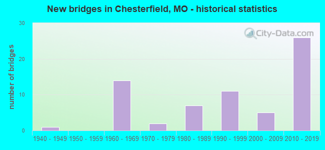
- New bridges - historical statistics
- 11940-1949
- 141960-1969
- 21970-1979
- 71980-1989
- 111990-1999
- 52000-2009
- 262010-2019
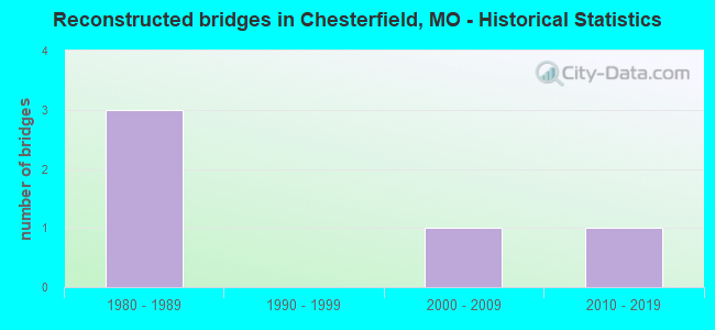
- Reconstructed bridges - Historical Statistics
- 31980-1989
- 01990-1999
- 12000-2009
- 12010-2019
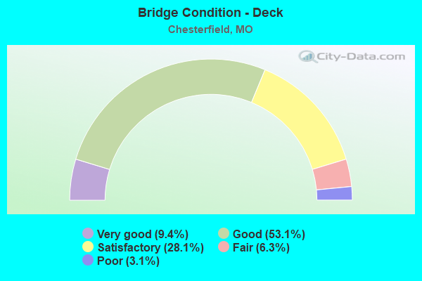
- Bridge Condition - Deck
- 9.4%Very good
- 53.1%Good
- 28.1%Satisfactory
- 6.3%Fair
- 3.1%Poor
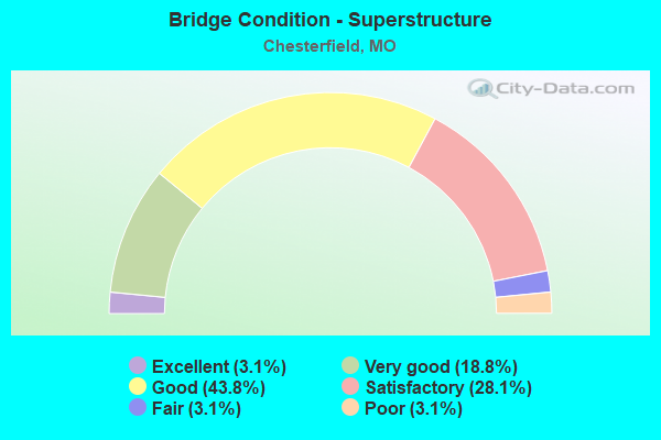
- Bridge Condition - Superstructure
- 3.1%Excellent
- 18.8%Very good
- 43.8%Good
- 28.1%Satisfactory
- 3.1%Fair
- 3.1%Poor
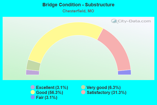
- Bridge Condition - Substructure
- 3.1%Excellent
- 6.3%Very good
- 56.3%Good
- 31.3%Satisfactory
- 3.1%Fair
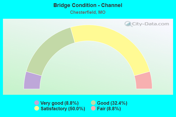
- Bridge Condition - Channel
- 8.8%Very good
- 32.4%Good
- 50.0%Satisfactory
- 8.8%Fair
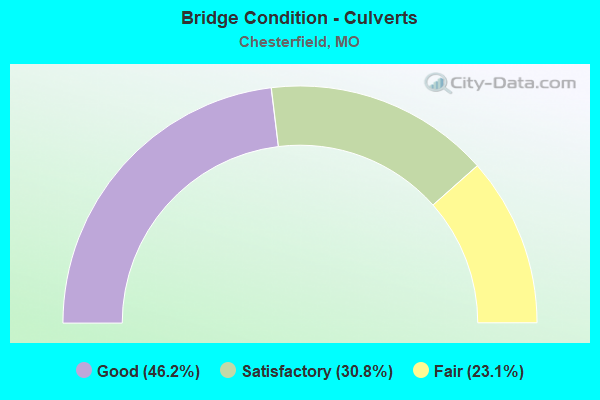
- Bridge Condition - Culverts
- 46.2%Good
- 30.8%Satisfactory
- 23.1%Fair
Find on map >> Show street view
Structure Number: 1371, Location: S 2031 T 45 N R 4 E (Lat: 38.665072, Lng: -90.573072), Route carried "on" structure: Interstate 64, Year Built: 1968, Year Reconstructed: 1987, Status: Posted for load, Structure Length: 8.69m (28.51ft), Average Daily Traffic: 48,507 (year 2021), Truck Traffic: 8%, Average Future Daily Traffic: 60,634 (year 2041), Design Load: HS 20, Features Intersected: UP RR, BONHOMME CR
Minimum Vertical Clearance: 30+ m (98+ ft), Kilometerpoint: 35.650, Lanes on structure: 3, Base Highway Network: Yes, Owner: State Highway Agency, Approaching Roadway Width: 16.5m (54.1ft), Skew: 1 degrees, Material/Design: Steel continuous, Design/Construction: Stringer/Multi-beam, Number Of Spans In Main Unit: 3, Number Of Approach Spans: 1, Length of Maximum Span: 29.8m (97.8ft), Curb or Sidewalk Widths: Left: 0.2m (0.7ft), Right: 0.2m (0.7ft), Curb-To-Curb Width: 15.5m (50.9ft), Out-to-Out Width: 16.3m (53.5ft)
Condition: Deck: Satisfactory, Superstructure: Satisfactory, Substructure: Fair, Channel: Satisfactory, Operating Rating: 52.2 metric tons, Method Used To Determine Operating Rating: Load Factor (LF), Inventory Rating: 31.5 metric tons, Method Used To Determine Inventory Rating: Load Factor (LF), Structural Evaluation: Somewhat better than minimum adequacy, Deck Geometry: Somewhat better than minimum adequacy, Underclear: Equal to present desirable criteria, Waterway Adequacy: Equal to present desirable criteria, Approach Roadway Alignment: Equal to present minimum criteria, Designated Inspection Frequency: Every 24 months, Inspection Date: October 2020, Deck Structure Type: Concrete Cast-file-Place, Wearing Surface/Protective System: Wearing Surface: Low Slump Concrete, Membrane: Built-up
Find on map >> Show street view
Structure Number: 1372, Location: S 415 T 45 N R 4 E (Lat: 38.652958, Lng: -90.558458), Route carried "on" structure: Interstate 64, Year Built: 1968, Year Reconstructed: 1989, Status: Open, Structure Length: 7.47m (24.51ft), Average Daily Traffic: 43,820 (year 2021), Truck Traffic: 11%, Average Future Daily Traffic: 54,775 (year 2041), Design Load: HS 20, Features Intersected: MO 340
Minimum Vertical Clearance: 30+ m (98+ ft), Kilometerpoint: 31.905, Lanes on structure: 3, Lanes under structure: 6, Base Highway Network: Yes, Owner: State Highway Agency, Approaching Roadway Width: 14.9m (48.9ft), Skew: 1 degrees, Material/Design: Concrete continuous, Design/Construction: Slab, Number Of Spans In Main Unit: 4, Length of Maximum Span: 21.3m (69.9ft), Curb-To-Curb Width: 15.1m (49.5ft), Out-to-Out Width: 16.0m (52.5ft)
Condition: Deck: Fair, Superstructure: Fair, Substructure: Good, Operating Rating: 64.8 metric tons, Method Used To Determine Operating Rating: Load Factor (LF), Inventory Rating: 38.7 metric tons, Method Used To Determine Inventory Rating: Load Factor (LF), Structural Evaluation: Somewhat better than minimum adequacy, Deck Geometry: Meets minimum limits, Underclear: Somewhat better than minimum adequacy, Approach Roadway Alignment: Better than present minimum criteria, Designated Inspection Frequency: Every 24 months, Inspection Date: October 2020, Deck Structure Type: Concrete Cast-file-Place, Wearing Surface/Protective System: Wearing Surface: Bituminous
Find on map >> Show street view
Structure Number: 1373, Location: S 415 T 45 N R 4 E (Lat: 38.653053, Lng: -90.558331), Route carried "on" structure: Interstate 64, Year Built: 1968, Year Reconstructed: 1989, Status: Open, Structure Length: 7.47m (24.51ft), Average Daily Traffic: 63,620 (year 2021), Truck Traffic: 8%, Average Future Daily Traffic: 79,525 (year 2041), Design Load: HS 20, Features Intersected: MO 340
Minimum Vertical Clearance: 30+ m (98+ ft), Kilometerpoint: 33.706, Lanes on structure: 3, Lanes under structure: 6, Base Highway Network: Yes, Owner: State Highway Agency, Approaching Roadway Width: 14.9m (48.9ft), Skew: 1 degrees, Material/Design: Concrete continuous, Design/Construction: Slab, Number Of Spans In Main Unit: 4, Length of Maximum Span: 21.3m (69.9ft), Curb-To-Curb Width: 15.1m (49.5ft), Out-to-Out Width: 16.0m (52.5ft)
Condition: Deck: Satisfactory, Superstructure: Satisfactory, Substructure: Good, Operating Rating: 64.8 metric tons, Method Used To Determine Operating Rating: Load Factor (LF), Inventory Rating: 38.7 metric tons, Method Used To Determine Inventory Rating: Load Factor (LF), Structural Evaluation: Equal to present minimum criteria, Deck Geometry: Meets minimum limits, Underclear: Somewhat better than minimum adequacy, Approach Roadway Alignment: Better than present minimum criteria, Designated Inspection Frequency: Every 24 months, Inspection Date: October 2020, Deck Structure Type: Concrete Cast-file-Place, Wearing Surface/Protective System: Wearing Surface: Bituminous, Membrane: Built-up
Find on map >> Show street view
Structure Number: 14932, Location: S 16 T 45 N R 4 E (Lat: 38.643478, Lng: -90.574017), Route carried "on" structure: City street , Year Built: 1987, Status: Open, Structure Length: 0.73m (2.40ft), Average Daily Traffic: 513 (year 2020), Truck Traffic: 1%, Average Future Daily Traffic: 693 (year 2040), Features Intersected: BR OF CAULK CR, Facility Carried by Structure: BAXTER FOREST RIDG
Minimum Vertical Clearance: 30+ m (98+ ft), Kilometerpoint: 0.322, Lanes on structure: 2, Owner: City or Municipal Highway Agency, Approaching Roadway Width: 7.3m (24.0ft), Material/Design: Concrete, Design/Construction: Culvert, Number Of Spans In Main Unit: 2, Length of Maximum Span: 3.0m (9.8ft), Curb or Sidewalk Widths: Left: 1.2m (3.9ft), Right: 1.2m (3.9ft), Curb-To-Curb Width: 7.3m (24.0ft), Out-to-Out Width: 7.9m (25.9ft)
Condition: Channel: Satisfactory, Culverts: Good, Operating Rating: 49.5 metric tons, Method Used To Determine Operating Rating: Allowable Stress (AS), Inventory Rating: 32.4 metric tons, Method Used To Determine Inventory Rating: Allowable Stress (AS), Structural Evaluation: Better than present minimum criteria, Deck Geometry: Meets minimum limits, Waterway Adequacy: Equal to present desirable criteria, Approach Roadway Alignment: Equal to present minimum criteria, Designated Inspection Frequency: Every 24 months, Inspection Date: December 2021
Find on map >> Show street view
Structure Number: 14933, Location: S 8 T 44 N R 5 E (Lat: 38.655500, Lng: -90.505744), Route carried "on" structure: City street , Year Built: 1978, Status: Posted for load, Structure Length: 0.94m (3.08ft), Average Daily Traffic: 550 (year 2020), Truck Traffic: 1%, Average Future Daily Traffic: 743 (year 2040), Design Load: HS 20, Features Intersected: CREVE COEUR CR, Facility Carried by Structure: LADUE FARM RD
Minimum Vertical Clearance: 30+ m (98+ ft), Kilometerpoint: 4.023, Lanes on structure: 2, Owner: City or Municipal Highway Agency, Approaching Roadway Width: 12.2m (40.0ft), Material/Design: Concrete, Design/Construction: Culvert, Number Of Spans In Main Unit: 2, Length of Maximum Span: 4.3m (14.1ft), Curb or Sidewalk Widths: Left: 0.2m (0.7ft), Right: 0.2m (0.7ft), Curb-To-Curb Width: 7.9m (25.9ft), Out-to-Out Width: 11.6m (38.1ft)
Condition: Channel: Fair, Culverts: Fair, Operating Rating: 35.1 metric tons, Method Used To Determine Operating Rating: Allowable Stress (AS), Inventory Rating: 22.5 metric tons, Method Used To Determine Inventory Rating: Allowable Stress (AS), Structural Evaluation: Somewhat better than minimum adequacy, Deck Geometry: Somewhat better than minimum adequacy, Waterway Adequacy: Equal to present desirable criteria, Approach Roadway Alignment: Somewhat better than minimum adequacy, Designated Inspection Frequency: Every 24 months, Inspection Date: December 2021
Find on map >> Show street view
Structure Number: 14935, Location: S 479 T 45 N R 3 E (Lat: 38.649806, Lng: -90.629556), Route carried "on" structure: City street , Year Built: 1989, Status: Posted for load, Structure Length: 6.49m (21.29ft), Average Daily Traffic: 3,556 (year 2020), Truck Traffic: 10%, Average Future Daily Traffic: 4,801 (year 2040), Features Intersected: BONHOMME CR, Facility Carried by Structure: WILDHORSE PKWY DR
Minimum Vertical Clearance: 30+ m (98+ ft), Kilometerpoint: 15.128, Lanes on structure: 2, Owner: City or Municipal Highway Agency, Approaching Roadway Width: 11.6m (38.1ft), Material/Design: Prestressed concrete continuous, Design/Construction: Stringer/Multi-beam, Number Of Spans In Main Unit: 3, Length of Maximum Span: 20.7m (67.9ft), Curb or Sidewalk Widths: Left: 1.2m (3.9ft), Right: 1.2m (3.9ft), Curb-To-Curb Width: 11.6m (38.1ft), Out-to-Out Width: 14.6m (47.9ft)
Condition: Deck: Satisfactory, Superstructure: Very good, Substructure: Good, Channel: Satisfactory, Operating Rating: 89.1 metric tons, Method Used To Determine Operating Rating: Allowable Stress (AS), Inventory Rating: 54.0 metric tons, Method Used To Determine Inventory Rating: Allowable Stress (AS), Structural Evaluation: Better than present minimum criteria, Deck Geometry: Somewhat better than minimum adequacy, Waterway Adequacy: Superior to present desirable criteria, Approach Roadway Alignment: Equal to present minimum criteria, Designated Inspection Frequency: Every 24 months, Inspection Date: December 2021, Deck Structure Type: Concrete Cast-file-Place, Wearing Surface/Protective System: Wearing Surface: Monolithic Concrete, Membrane: Epoxy, Deck Protection: Epoxy Coated Reinforcing
Find on map >> Show street view
Structure Number: 15659, Location: S 4 T 45 N R 4 E (Lat: 38.665242, Lng: -90.579656), Route carried "on" structure: County highway , Year Built: 1984, Status: Posted for load, Structure Length: 3.47m (11.38ft), Average Daily Traffic: 16,220 (year 2020), Truck Traffic: 10%, Average Future Daily Traffic: 21,897 (year 2040), Design Load: HS 20, Features Intersected: BONHOMME CR, Facility Carried by Structure: BAXTER RD
Minimum Vertical Clearance: 30+ m (98+ ft), Kilometerpoint: 0.000, Lanes on structure: 2, Owner: County Highway Agency, Approaching Roadway Width: 11.9m (39.0ft), Material/Design: Prestressed concrete continuous, Design/Construction: Stringer/Multi-beam, Number Of Spans In Main Unit: 3, Length of Maximum Span: 15.5m (50.9ft), Curb-To-Curb Width: 11.9m (39.0ft), Out-to-Out Width: 12.6m (41.3ft)
Condition: Deck: Good, Superstructure: Satisfactory, Substructure: Satisfactory, Channel: Good, Operating Rating: 45.9 metric tons, Method Used To Determine Operating Rating: Allowable Stress (AS), Inventory Rating: 29.7 metric tons, Method Used To Determine Inventory Rating: Allowable Stress (AS), Structural Evaluation: Equal to present minimum criteria, Deck Geometry: Somewhat better than minimum adequacy, Waterway Adequacy: Equal to present desirable criteria, Approach Roadway Alignment: Equal to present minimum criteria, Designated Inspection Frequency: Every 24 months, Inspection Date: March 2020, Deck Structure Type: Concrete Cast-file-Place, Wearing Surface/Protective System: Wearing Surface: Monolithic Concrete, Membrane: Epoxy, Deck Protection: Epoxy Coated Reinforcing
Find on map >> Show street view
Structure Number: 1852, Location: S 371 T 45 N R 3 E (Lat: 38.674539, Lng: -90.645581), Route carried "on" structure: City street , Year Built: 1968, Year Reconstructed: 2010, Status: Posted for load, Structure Length: 7.30m (23.95ft), Average Daily Traffic: 789 (year 2021), Truck Traffic: 5%, Average Future Daily Traffic: 1,184 (year 2041), Design Load: H 20, Features Intersected: IS 64, Facility Carried by Structure: SPIRIT OF ST LOUIS
Minimum Vertical Clearance: 30+ m (98+ ft), Kilometerpoint: 0.029, Lanes on structure: 3, Lanes under structure: 6, Owner: State Highway Agency, Approaching Roadway Width: 11.6m (38.1ft), Material/Design: Steel continuous, Design/Construction: Stringer/Multi-beam, Number Of Spans In Main Unit: 2, Number Of Approach Spans: 2, Length of Maximum Span: 26.2m (86.0ft), Curb-To-Curb Width: 11.6m (38.1ft), Out-to-Out Width: 12.4m (40.7ft)
Condition: Deck: Good, Superstructure: Satisfactory, Substructure: Good, Operating Rating: 38.7 metric tons, Method Used To Determine Operating Rating: Load Factor (LF), Inventory Rating: 23.4 metric tons, Method Used To Determine Inventory Rating: Load Factor (LF), Structural Evaluation: Equal to present minimum criteria, Deck Geometry: High priority of replacement, Underclear: Equal to present minimum criteria, Approach Roadway Alignment: Equal to present minimum criteria, Designated Inspection Frequency: Every 24 months, Inspection Date: October 2020, Deck Structure Type: Concrete Cast-file-Place, Wearing Surface/Protective System: Wearing Surface: Monolithic Concrete, Deck Protection: Epoxy Coated Reinforcing
Find on map >> Show street view
Structure Number: 1853, Location: S 126 T 45 N R 4 E (Lat: 38.671956, Lng: -90.616992), Route carried "on" structure: Ramp State highway , Year Built: 1968, Status: Open, Structure Length: 8.90m (29.20ft), Average Daily Traffic: 7,355 (year 2021), Truck Traffic: 6%, Average Future Daily Traffic: 9,194 (year 2041), Design Load: HS 20, Features Intersected: IS 64, Facility Carried by Structure: RP IS64W TO LONG R
Minimum Vertical Clearance: 30+ m (98+ ft), Kilometerpoint: 0.552, Lanes on structure: 1, Lanes under structure: 6, Base Highway Network: Yes, Owner: State Highway Agency, Approaching Roadway Width: 7.3m (24.0ft), Material/Design: Concrete continuous, Design/Construction: Box Beam or Girders - Single/Spread, Number Of Spans In Main Unit: 4, Length of Maximum Span: 28.3m (92.8ft), Curb-To-Curb Width: 7.3m (24.0ft), Out-to-Out Width: 8.1m (26.6ft)
Condition: Deck: Poor, Superstructure: Poor, Substructure: Satisfactory, Operating Rating: 66.6 metric tons, Method Used To Determine Operating Rating: Load Factor (LF), Inventory Rating: 39.6 metric tons, Method Used To Determine Inventory Rating: Load Factor (LF), Structural Evaluation: Meets minimum limits, Deck Geometry: Better than present minimum criteria, Underclear: Meets minimum limits, Approach Roadway Alignment: Equal to present minimum criteria, Length Of Structure Improvement: 0.99m (3.25ft), Designated Inspection Frequency: Every 24 months, Inspection Date: October 2020, Bridge Improvement Cost: $809,000, Roadway Improvement Cost: $81,000, Total Project Cost: $1,213,000 ( Estimate for 2022), Deck Structure Type: Concrete Cast-file-Place, Wearing Surface/Protective System: Wearing Surface: Bituminous, Membrane: Built-up
Find on map >> Show street view
Structure Number: 25326, Location: S 27 T 51 N R 33 W (Lat: 39.199744, Lng: -94.586169), Route carried "on" structure: City street , Year Built: 1979, Status: Posted for load, Structure Length: 0.73m (2.40ft), Average Daily Traffic: 192 (year 2020), Truck Traffic: 16%, Average Future Daily Traffic: 307 (year 2040), Features Intersected: EAST CR, Facility Carried by Structure: N W 58TH ST
Minimum Vertical Clearance: 30+ m (98+ ft), Kilometerpoint: 0.161, Lanes on structure: 2, Owner: City or Municipal Highway Agency, Approaching Roadway Width: 9.1m (29.9ft), Skew: 3 degrees, Material/Design: Concrete, Design/Construction: Slab, Number Of Spans In Main Unit: 1, Length of Maximum Span: 7.0m (23.0ft), Curb-To-Curb Width: 9.3m (30.5ft), Out-to-Out Width: 9.8m (32.2ft)
Condition: Deck: Good, Superstructure: Good, Substructure: Good, Channel: Satisfactory, Operating Rating: 27.0 metric tons, Method Used To Determine Operating Rating: Load Factor (LF), Inventory Rating: 16.2 metric tons, Method Used To Determine Inventory Rating: Load Factor (LF), Structural Evaluation: Somewhat better than minimum adequacy, Deck Geometry: Equal to present minimum criteria, Waterway Adequacy: Better than present minimum criteria, Approach Roadway Alignment: Equal to present desirable criteria, Bridge Posting: Required (Relationship of Operating Rating to Maximum Legal Load: 0.1 - 9.9% below), Designated Inspection Frequency: Every 24 months, Inspection Date: Febuary 2020, Deck Structure Type: Concrete Cast-file-Place, Wearing Surface/Protective System: Wearing Surface: Bituminous
Find on map >> Show street view
Structure Number: 25479, Location: S 11 T 48 N R 33 W (Lat: 38.997642, Lng: -94.538689), Route carried "on" structure: City street 222, Year Built: 1993, Status: Open, Structure Length: 10.67m (35.01ft), Average Daily Traffic: 9,678 (year 2021), Truck Traffic: 26%, Average Future Daily Traffic: 12,581 (year 2041), Design Load: HS 20, Features Intersected: CREEK, Facility Carried by Structure: GREGORY BLVD
Minimum Vertical Clearance: 30+ m (98+ ft), Kilometerpoint: 0.000, Lanes on structure: 2, Owner: City or Municipal Highway Agency, Approaching Roadway Width: 8.5m (27.9ft), Material/Design: Prestressed concrete continuous, Design/Construction: Stringer/Multi-beam, Number Of Spans In Main Unit: 5, Length of Maximum Span: 22.9m (75.1ft), Curb or Sidewalk Widths: Left: 0.4m (1.3ft), Right: 2.1m (6.9ft), Curb-To-Curb Width: 8.5m (27.9ft), Out-to-Out Width: 11.0m (36.1ft)
Condition: Deck: Good, Superstructure: Very good, Substructure: Good, Channel: Very good, Operating Rating: 59.4 metric tons, Method Used To Determine Operating Rating: Allowable Stress (AS), Inventory Rating: 44.1 metric tons, Method Used To Determine Inventory Rating: Allowable Stress (AS), Structural Evaluation: Better than present minimum criteria, Deck Geometry: Meets minimum limits, Waterway Adequacy: Superior to present desirable criteria, Approach Roadway Alignment: Equal to present desirable criteria, Designated Inspection Frequency: Every 24 months, Inspection Date: Febuary 2020, Deck Structure Type: Concrete Precast Panels, Wearing Surface/Protective System: Wearing Surface: Monolithic Concrete, Deck Protection: Epoxy Coated Reinforcing
Find on map >> Show street view
Structure Number: 30101, Location: S 5 T 44 N R 4 E (Lat: 38.652778, Lng: -90.597267), Route carried "on" structure: City street , Year Built: 2001, Status: Open, Structure Length: 5.70m (18.70ft), Average Daily Traffic: 563 (year 2020), Truck Traffic: 2%, Average Future Daily Traffic: 760 (year 2040), Design Load: HS 20+Mod, Features Intersected: CAULKS CR, Facility Carried by Structure: EAGLE BLUFF
Minimum Vertical Clearance: 30+ m (98+ ft), Kilometerpoint: 0.000, Lanes on structure: 2, Owner: City or Municipal Highway Agency, Approaching Roadway Width: 8.5m (27.9ft), Material/Design: Prestressed concrete continuous, Design/Construction: Stringer/Multi-beam, Number Of Spans In Main Unit: 3, Length of Maximum Span: 26.5m (86.9ft), Curb-To-Curb Width: 8.8m (28.9ft), Out-to-Out Width: 12.4m (40.7ft)
Condition: Deck: Good, Superstructure: Good, Substructure: Good, Channel: Good, Operating Rating: 69.3 metric tons, Method Used To Determine Operating Rating: Load Factor (LF), Inventory Rating: 41.4 metric tons, Method Used To Determine Inventory Rating: Load Factor (LF), Structural Evaluation: Better than present minimum criteria, Deck Geometry: Somewhat better than minimum adequacy, Waterway Adequacy: Equal to present desirable criteria, Approach Roadway Alignment: Equal to present minimum criteria, Designated Inspection Frequency: Every 24 months, Inspection Date: December 2021, Deck Structure Type: Concrete Cast-file-Place
Find on map >> Show street view
Structure Number: 31251, Location: S 11 T 45 N R 4 E (Lat: 38.649203, Lng: -90.523289), Route carried "on" structure: County highway 141, Year Built: 2004, Status: Posted for load, Structure Length: 2.77m (9.09ft), Average Daily Traffic: 6,780 (year 2020), Truck Traffic: 5%, Average Future Daily Traffic: 9,153 (year 2040), Design Load: HS 25 or greater, Features Intersected: CREVE COEUR CR, Facility Carried by Structure: CONWAY RD
Minimum Vertical Clearance: 30+ m (98+ ft), Kilometerpoint: 0.000, Lanes on structure: 2, Owner: County Highway Agency, Approaching Roadway Width: 11.6m (38.1ft), Skew: 4 degrees, Material/Design: Prestressed concrete continuous, Design/Construction: Stringer/Multi-beam, Number Of Spans In Main Unit: 2, Length of Maximum Span: 13.1m (43.0ft), Curb or Sidewalk Widths: Left: 1.5m (4.9ft), Right: 1.5m (4.9ft), Curb-To-Curb Width: 12.2m (40.0ft), Out-to-Out Width: 16.4m (53.8ft)
Condition: Deck: Satisfactory, Superstructure: Good, Substructure: Good, Channel: Satisfactory, Inventory Rating: 63.0 metric tons, Method Used To Determine Inventory Rating: Load Factor (LF), Structural Evaluation: Better than present minimum criteria, Deck Geometry: Somewhat better than minimum adequacy, Waterway Adequacy: Equal to present desirable criteria, Approach Roadway Alignment: Equal to present desirable criteria, Designated Inspection Frequency: Every 24 months, Inspection Date: March 2021, Deck Structure Type: Concrete Cast-file-Place, Wearing Surface/Protective System: Wearing Surface: Monolithic Concrete, Membrane: Other, Deck Protection: Epoxy Coated Reinforcing
Find on map >> Show street view
Structure Number: 32406, Location: S 4 T 45 N R 4 E (Lat: 38.660594, Lng: -90.576689), Route carried "on" structure: County highway 141, Year Built: 2007, Status: Posted for load, Structure Length: 0.67m (2.20ft), Average Daily Traffic: 7,807 (year 2020), Truck Traffic: 5%, Average Future Daily Traffic: 10,539 (year 2040), Design Load: HS 20, Features Intersected: CHESTERFIELD CR, Facility Carried by Structure: WILD HORSE CR RD
Minimum Vertical Clearance: 30+ m (98+ ft), Kilometerpoint: 0.000, Lanes on structure: 2, Owner: County Highway Agency, Approaching Roadway Width: 11.0m (36.1ft), Material/Design: Concrete continuous, Design/Construction: Culvert, Number Of Spans In Main Unit: 2, Length of Maximum Span: 3.0m (9.8ft), Curb or Sidewalk Widths: Left: 1.5m (4.9ft), Right: 1.5m (4.9ft)
Condition: Channel: Satisfactory, Culverts: Good, Inventory Rating: 89.1 metric tons, Method Used To Determine Inventory Rating: Allowable Stress (AS), Structural Evaluation: Better than present minimum criteria, Waterway Adequacy: Superior to present desirable criteria, Approach Roadway Alignment: Equal to present desirable criteria, Designated Inspection Frequency: Every 24 months, Inspection Date: March 2020
Find on map >> Show street view
Structure Number: 32816, Location: S 8 T 45 N R 4 E (Lat: 38.653611, Lng: -90.590233), Route carried "on" structure: City street , Year Built: 2009, Status: Open, Structure Length: 1.28m (4.20ft), Average Daily Traffic: 184 (year 2020), Truck Traffic: 1%, Average Future Daily Traffic: 248 (year 2040), Design Load: HS 20, Features Intersected: WILSON CR, Facility Carried by Structure: TODD EVAN TRAIL
Minimum Vertical Clearance: 30+ m (98+ ft), Kilometerpoint: 0.000, Lanes on structure: 2, Owner: City or Municipal Highway Agency, Approaching Roadway Width: 7.9m (25.9ft), Material/Design: Concrete, Design/Construction: Culvert, Number Of Spans In Main Unit: 1, Length of Maximum Span: 12.8m (42.0ft), Curb or Sidewalk Widths: Left: 0.9m (3.0ft), Right: 2.2m (7.2ft), Curb-To-Curb Width: 8.8m (28.9ft), Out-to-Out Width: 13.3m (43.6ft)
Condition: Channel: Good, Culverts: Good, Operating Rating: 54.0 metric tons, Method Used To Determine Operating Rating: Load Factor (LF), Inventory Rating: 32.4 metric tons, Method Used To Determine Inventory Rating: Load Factor (LF), Structural Evaluation: Better than present minimum criteria, Deck Geometry: Equal to present minimum criteria, Waterway Adequacy: Superior to present desirable criteria, Approach Roadway Alignment: Equal to present desirable criteria, Designated Inspection Frequency: Every 24 months, Inspection Date: December 2021
Find on map >> Show street view
Structure Number: 32943, Location: S 109 T 45 N R 5 E (Lat: 38.660278, Lng: -90.503378), Route carried "on" structure: State highway AB, Year Built: 2011, Status: Open, Structure Length: 2.93m (9.61ft), Average Daily Traffic: 8,701 (year 2021), Truck Traffic: 4%, Average Future Daily Traffic: 12,181 (year 2041), Features Intersected: MO 141
Minimum Vertical Clearance: 30+ m (98+ ft), Kilometerpoint: 0.138, Lanes on structure: 6, Lanes under structure: 4, Owner: State Highway Agency, Approaching Roadway Width: 26.8m (87.9ft), Skew: 2 degrees, Material/Design: Prestressed concrete continuous, Design/Construction: Stringer/Multi-beam, Number Of Spans In Main Unit: 1, Length of Maximum Span: 28.7m (94.2ft), Curb-To-Curb Width: 63.6m (208.7ft), Out-to-Out Width: 64.4m (211.3ft)
Condition: Deck: Satisfactory, Superstructure: Good, Substructure: Good, Operating Rating: 65.7 metric tons, Method Used To Determine Operating Rating: Load Factor (LF), Inventory Rating: 31.5 metric tons, Method Used To Determine Inventory Rating: Load Factor (LF), Structural Evaluation: Better than present minimum criteria, Deck Geometry: Superior to present desirable criteria, Approach Roadway Alignment: Equal to present desirable criteria, Designated Inspection Frequency: Every 24 months, Inspection Date: October 2020, Deck Structure Type: Concrete Cast-file-Place, Wearing Surface/Protective System: Wearing Surface: Monolithic Concrete, Deck Protection: Epoxy Coated Reinforcing
Find on map >> Show street view
Structure Number: 32944, Location: S 109 T 45 N R 5 E (Lat: 38.660556, Lng: -90.504722), Route carried "on" structure: State highway AB, Year Built: 2012, Status: Open, Structure Length: 3.87m (12.70ft), Average Daily Traffic: 8,701 (year 2021), Truck Traffic: 4%, Average Future Daily Traffic: 13,052 (year 2041), Features Intersected: CST N WOODS MILL RD, MAR
Minimum Vertical Clearance: 30+ m (98+ ft), Kilometerpoint: 0.056, Lanes on structure: 6, Lanes under structure: 2, Owner: State Highway Agency, Approaching Roadway Width: 25.6m (84.0ft), Skew: 2 degrees, Material/Design: Prestressed concrete, Design/Construction: Tee Beam, Number Of Spans In Main Unit: 1, Length of Maximum Span: 38.1m (125.0ft), Curb-To-Curb Width: 25.6m (84.0ft), Out-to-Out Width: 27.6m (90.6ft)
Condition: Deck: Good, Superstructure: Good, Substructure: Good, Channel: Very good, Operating Rating: 71.1 metric tons, Method Used To Determine Operating Rating: Load Factor (LF), Inventory Rating: 36.9 metric tons, Method Used To Determine Inventory Rating: Load Factor (LF), Structural Evaluation: Better than present minimum criteria, Deck Geometry: Somewhat better than minimum adequacy, Underclear: Meets minimum limits, Waterway Adequacy: Superior to present desirable criteria, Approach Roadway Alignment: Equal to present desirable criteria, Designated Inspection Frequency: Every 24 months, Inspection Date: October 2020, Deck Structure Type: Concrete Cast-file-Place, Wearing Surface/Protective System: Wearing Surface: Monolithic Concrete, Deck Protection: Epoxy Coated Reinforcing
Find on map >> Show street view
Structure Number: 3297, Location: S 11 T 54 N R 2 W (Lat: 39.468278, Lng: -91.087208), Route carried "on" structure: State highway 79, Year Built: 1981, Status: Open, Structure Length: 3.23m (10.60ft), Average Daily Traffic: 856 (year 2021), Truck Traffic: 7%, Average Future Daily Traffic: 1,327 (year 2041), Design Load: H 20, Features Intersected: TANYARD BR
Minimum Vertical Clearance: 30+ m (98+ ft), Kilometerpoint: 49.901, Lanes on structure: 2, Base Highway Network: Yes, Owner: State Highway Agency, Approaching Roadway Width: 7.9m (25.9ft), Skew: 3 degrees, Material/Design: Prestressed concrete continuous, Design/Construction: Tee Beam, Number Of Spans In Main Unit: 3, Length of Maximum Span: 10.9m (35.8ft), Curb or Sidewalk Widths: Left: 0.2m (0.7ft), Right: 0.2m (0.7ft), Curb-To-Curb Width: 11.6m (38.1ft), Out-to-Out Width: 12.4m (40.7ft)
Condition: Deck: Good, Superstructure: Good, Substructure: Satisfactory, Channel: Satisfactory, Operating Rating: 42.3 metric tons, Method Used To Determine Operating Rating: Load Factor (LF), Inventory Rating: 25.2 metric tons, Method Used To Determine Inventory Rating: Load Factor (LF), Structural Evaluation: Equal to present minimum criteria, Deck Geometry: Better than present minimum criteria, Waterway Adequacy: Equal to present desirable criteria, Approach Roadway Alignment: Equal to present desirable criteria, Designated Inspection Frequency: Every 24 months, Inspection Date: December 2020, Deck Structure Type: Concrete Cast-file-Place, Wearing Surface/Protective System: Wearing Surface: Bituminous, Deck Protection: Internally Sealed
Find on map >> Show street view
Structure Number: 32973, Location: S 367 T 46 N R 5 E (Lat: 38.681358, Lng: -90.493358), Route carried "on" structure: State highway 340, Year Built: 2011, Status: Open, Structure Length: 2.94m (9.65ft), Average Daily Traffic: 24,403 (year 2021), Truck Traffic: 7%, Average Future Daily Traffic: 34,164 (year 2041), Features Intersected: MO 141
Minimum Vertical Clearance: 30+ m (98+ ft), Kilometerpoint: 14.365, Lanes on structure: 8, Lanes under structure: 4, Base Highway Network: Yes, Owner: State Highway Agency, Approaching Roadway Width: 54.6m (179.1ft), Skew: 2 degrees, Material/Design: Prestressed concrete, Design/Construction: Stringer/Multi-beam, Number Of Spans In Main Unit: 1, Length of Maximum Span: 28.7m (94.2ft), Curb-To-Curb Width: 53.7m (176.2ft), Out-to-Out Width: 54.6m (179.1ft)
Condition: Deck: Satisfactory, Superstructure: Very good, Substructure: Good, Operating Rating: 63.9 metric tons, Method Used To Determine Operating Rating: Load Factor (LF), Inventory Rating: 38.7 metric tons, Method Used To Determine Inventory Rating: Load Factor (LF), Structural Evaluation: Better than present minimum criteria, Deck Geometry: Superior to present desirable criteria, Approach Roadway Alignment: Equal to present desirable criteria, Designated Inspection Frequency: Every 24 months, Inspection Date: October 2020, Deck Structure Type: Concrete Cast-file-Place, Wearing Surface/Protective System: Wearing Surface: Monolithic Concrete, Deck Protection: Epoxy Coated Reinforcing
Find on map >> Show street view
Structure Number: 33814, Location: S 109 T 45 N R 5 E (Lat: 38.658447, Lng: -90.505497), Route carried "on" structure: State highway 141, Year Built: 2010, Status: Open, Structure Length: 1.34m (4.40ft), Average Daily Traffic: 30,491 (year 2021), Truck Traffic: 5%, Average Future Daily Traffic: 38,114 (year 2041), Design Load: HS 20, Features Intersected: MARYVILLE CR OVRFL
Minimum Vertical Clearance: 30+ m (98+ ft), Kilometerpoint: 17.753, Lanes on structure: 6, Base Highway Network: Yes, Owner: State Highway Agency, Approaching Roadway Width: 11.0m (36.1ft), Skew: 4 degrees, Material/Design: Concrete continuous, Design/Construction: Culvert, Number Of Spans In Main Unit: 2, Length of Maximum Span: 6.5m (21.3ft)
Condition: Channel: Satisfactory, Culverts: Satisfactory, Operating Rating: 62.1 metric tons, Method Used To Determine Operating Rating: Load Factor (LF), Inventory Rating: 36.9 metric tons, Method Used To Determine Inventory Rating: Load Factor (LF), Structural Evaluation: Equal to present minimum criteria, Waterway Adequacy: Superior to present desirable criteria, Approach Roadway Alignment: Equal to present desirable criteria, Designated Inspection Frequency: Every 24 months, Inspection Date: November 2021
Find on map >> Show street view
Structure Number: 33815, Location: S 109 T 45 N R 5 E (Lat: 38.659258, Lng: -90.504711), Route carried "on" structure: State highway 141, Year Built: 2010, Status: Open, Structure Length: 0.83m (2.72ft), Average Daily Traffic: 30,491 (year 2021), Truck Traffic: 5%, Average Future Daily Traffic: 38,114 (year 2041), Design Load: HS 25 or greater, Features Intersected: MARYVILLE CR
Minimum Vertical Clearance: 30+ m (98+ ft), Kilometerpoint: 17.648, Lanes on structure: 4, Base Highway Network: Yes, Owner: State Highway Agency, Approaching Roadway Width: 11.0m (36.1ft), Skew: 1 degrees, Material/Design: Concrete continuous, Design/Construction: Culvert, Number Of Spans In Main Unit: 2, Length of Maximum Span: 4.0m (13.1ft)
Condition: Channel: Satisfactory, Culverts: Fair, Operating Rating: 87.3 metric tons, Method Used To Determine Operating Rating: Field evaluation and documented engineering judgment, Inventory Rating: 52.2 metric tons, Method Used To Determine Inventory Rating: Field evaluation and documented engineering judgment, Structural Evaluation: Somewhat better than minimum adequacy, Waterway Adequacy: Superior to present desirable criteria, Approach Roadway Alignment: Equal to present desirable criteria, Designated Inspection Frequency: Every 24 months, Inspection Date: November 2021
Find on map >> Show street view
Structure Number: 33816, Location: S 367 T 45 N R 5 E (Lat: 38.669792, Lng: -90.495978), Route carried "on" structure: State highway 141, Year Built: 2012, Status: Open, Structure Length: 0.90m (2.95ft), Average Daily Traffic: 12,393 (year 2021), Truck Traffic: 5%, Average Future Daily Traffic: 15,491 (year 2041), Design Load: HS 25 or greater, Features Intersected: CREVE COEUR CR
Minimum Vertical Clearance: 30+ m (98+ ft), Kilometerpoint: 16.216, Lanes on structure: 6, Base Highway Network: Yes, Owner: State Highway Agency, Approaching Roadway Width: 14.5m (47.6ft), Skew: 5 degrees, Material/Design: Concrete continuous, Design/Construction: Culvert, Number Of Spans In Main Unit: 2, Length of Maximum Span: 4.3m (14.1ft)
Condition: Channel: Fair, Culverts: Satisfactory, Operating Rating: 87.3 metric tons, Method Used To Determine Operating Rating: Field evaluation and documented engineering judgment, Inventory Rating: 52.2 metric tons, Method Used To Determine Inventory Rating: Field evaluation and documented engineering judgment, Structural Evaluation: Equal to present minimum criteria, Waterway Adequacy: Superior to present desirable criteria, Approach Roadway Alignment: Equal to present desirable criteria, Designated Inspection Frequency: Every 24 months, Inspection Date: November 2021
Find on map >> Show street view
Structure Number: 34086, Location: S 8 T 45 N R 4 E (Lat: 38.654722, Lng: -90.595000), Route carried "on" structure: County highway , Year Built: 2010, Status: Posted for load, Structure Length: 2.71m (8.89ft), Average Daily Traffic: 9,004 (year 2020), Truck Traffic: 10%, Average Future Daily Traffic: 12,155 (year 2040), Features Intersected: CAULKS CR, Facility Carried by Structure: WILD HORSE CR RD
Minimum Vertical Clearance: 30+ m (98+ ft), Kilometerpoint: 0.000, Lanes on structure: 2, Owner: County Highway Agency, Approaching Roadway Width: 13.4m (44.0ft), Skew: 2 degrees, Material/Design: Prestressed concrete, Design/Construction: Box Beam or Girders - Single/Spread, Number Of Spans In Main Unit: 1, Length of Maximum Span: 26.0m (85.3ft), Curb-To-Curb Width: 13.4m (44.0ft), Out-to-Out Width: 14.0m (45.9ft)
Condition: Deck: Good, Superstructure: Very good, Substructure: Very good, Channel: Good, Operating Rating: 41.4 metric tons, Method Used To Determine Operating Rating: Load and Resistance Factor (LRFR), Inventory Rating: 31.5 metric tons, Method Used To Determine Inventory Rating: Load and Resistance Factor (LRFR), Structural Evaluation: Better than present minimum criteria, Deck Geometry: Equal to present minimum criteria, Waterway Adequacy: Superior to present desirable criteria, Approach Roadway Alignment: Equal to present desirable criteria, Designated Inspection Frequency: Every 24 months, Inspection Date: March 2020, Deck Structure Type: Concrete Cast-file-Place, Wearing Surface/Protective System: Wearing Surface: Monolithic Concrete, Deck Protection: Epoxy Coated Reinforcing
Find on map >> Show street view
Structure Number: 34144, Location: S 7 T 45 N R 4 E (Lat: 38.657989, Lng: -90.618578), Route carried "on" structure: City street , Year Built: 2012, Status: Open, Structure Length: 3.86m (12.66ft), Average Daily Traffic: 18,432 (year 2020), Truck Traffic: 10%, Average Future Daily Traffic: 25,805 (year 2040), Design Load: HS 25 or greater, Features Intersected: BONHOMME CR, Facility Carried by Structure: KEHRS MILL RD E
Minimum Vertical Clearance: 30+ m (98+ ft), Kilometerpoint: 0.031, Lanes on structure: 5, Owner: State Highway Agency, Approaching Roadway Width: 20.1m (65.9ft), Skew: 1 degrees, Material/Design: Prestressed concrete continuous, Design/Construction: Stringer/Multi-beam, Number Of Spans In Main Unit: 3, Length of Maximum Span: 13.4m (44.0ft), Curb-To-Curb Width: 20.1m (65.9ft), Out-to-Out Width: 27.4m (89.9ft)
Condition: Deck: Good, Superstructure: Good, Substructure: Satisfactory, Channel: Good, Inventory Rating: 90.9 metric tons, Method Used To Determine Inventory Rating: Load Factor (LF), Structural Evaluation: Equal to present minimum criteria, Deck Geometry: Somewhat better than minimum adequacy, Waterway Adequacy: Superior to present desirable criteria, Approach Roadway Alignment: Equal to present minimum criteria, Designated Inspection Frequency: Every 24 months, Inspection Date: July 2020, Deck Structure Type: Concrete Cast-file-Place, Wearing Surface/Protective System: Wearing Surface: Monolithic Concrete, Deck Protection: Epoxy Coated Reinforcing
Find on map >> Show street view
Structure Number: 34201, Location: S 109 T 45 N R 5 E (Lat: 38.660858, Lng: -90.506358), Route carried "on" structure: City street , Year Built: 2012, Status: Open, Structure Length: 8.87m (29.10ft), Average Daily Traffic: 3,942 (year 2020), Truck Traffic: 5%, Average Future Daily Traffic: 5,322 (year 2040), Features Intersected: CREVE COEUR CR, Facility Carried by Structure: LADUE RD
Minimum Vertical Clearance: 30+ m (98+ ft), Kilometerpoint: 0.000, Lanes on structure: 2, Owner: City or Municipal Highway Agency, Approaching Roadway Width: 11.6m (38.1ft), Skew: 2 degrees, Material/Design: Prestressed concrete continuous, Design/Construction: Stringer/Multi-beam, Number Of Spans In Main Unit: 4, Length of Maximum Span: 22.9m (75.1ft), Curb or Sidewalk Widths: Left: 0.0m, Right: 2.1m (6.9ft), Curb-To-Curb Width: 13.4m (44.0ft), Out-to-Out Width: 14.2m (46.6ft)
Condition: Deck: Good, Superstructure: Good, Substructure: Good, Channel: Good, Operating Rating: 66.6 metric tons, Method Used To Determine Operating Rating: Load Factor (LF), Inventory Rating: 40.5 metric tons, Method Used To Determine Inventory Rating: Load Factor (LF), Structural Evaluation: Better than present minimum criteria, Deck Geometry: Better than present minimum criteria, Waterway Adequacy: Equal to present desirable criteria, Approach Roadway Alignment: Equal to present desirable criteria, Designated Inspection Frequency: Every 24 months, Inspection Date: December 2021, Deck Structure Type: Concrete Cast-file-Place, Wearing Surface/Protective System: Wearing Surface: Monolithic Concrete, Deck Protection: Epoxy Coated Reinforcing
Find on map >> Show street view
Structure Number: 3449, Location: S 371 T 45 N R 3 E (Lat: 38.676389, Lng: -90.656389), Route carried "on" structure: Ramp State highway , Year Built: 2013, Status: Open, Structure Length: 5.49m (18.01ft), Average Daily Traffic: 9,494 (year 2021), Truck Traffic: 5%, Average Future Daily Traffic: 11,868 (year 2041), Features Intersected: IS 64, Facility Carried by Structure: RP CHESTERFIELD AI
Minimum Vertical Clearance: 30+ m (98+ ft), Kilometerpoint: 0.278, Lanes on structure: 1, Lanes under structure: 6, Base Highway Network: Yes, Owner: State Highway Agency, Approaching Roadway Width: 7.9m (25.9ft), Skew: 2 degrees, Material/Design: Prestressed concrete continuous, Design/Construction: Tee Beam, Number Of Spans In Main Unit: 2, Length of Maximum Span: 26.8m (87.9ft), Curb-To-Curb Width: 7.9m (25.9ft), Out-to-Out Width: 8.8m (28.9ft)
Condition: Deck: Good, Superstructure: Good, Substructure: Good, Operating Rating: 72.9 metric tons, Method Used To Determine Operating Rating: Load Factor (LF), Inventory Rating: 43.2 metric tons, Method Used To Determine Inventory Rating: Load Factor (LF), Structural Evaluation: Better than present minimum criteria, Deck Geometry: Equal to present desirable criteria, Underclear: Meets minimum limits, Approach Roadway Alignment: Better than present minimum criteria, Designated Inspection Frequency: Every 24 months, Inspection Date: October 2020, Deck Structure Type: Concrete Cast-file-Place, Wearing Surface/Protective System: Wearing Surface: Monolithic Concrete, Deck Protection: Epoxy Coated Reinforcing
Find on map >> Show street view
Structure Number: 34492, Location: S 35 T 46 N R 3 E (Lat: 38.687389, Lng: -90.663275), Route carried "on" structure: Interstate 64, Year Built: 2013, Status: Open, Structure Length: 79.83m (261.91ft), Average Daily Traffic: 43,658 (year 2021), Truck Traffic: 11%, Average Future Daily Traffic: 74,219 (year 2041), Features Intersected: MISSOURI RVR, KATY TRAIL
Minimum Vertical Clearance: 30+ m (98+ ft), Kilometerpoint: 20.822, Lanes on structure: 4, Base Highway Network: Yes, Owner: State Highway Agency, Approaching Roadway Width: 19.5m (64.0ft), Navigation Control: Yes ( Vertical Clearance: 16.2m (53.1ft), Horizontal Clearance: 153.0m (502.0ft)), Material/Design: Steel continuous, Design/Construction: Stringer/Multi-beam, Number Of Spans In Main Unit: 3, Number Of Approach Spans: 8, Length of Maximum Span: 155.4m (509.8ft), Curb or Sidewalk Widths: Left: 0.0m, Right: 3.0m (9.8ft), Curb-To-Curb Width: 19.5m (64.0ft), Out-to-Out Width: 23.7m (77.8ft)
Condition: Deck: Good, Superstructure: Good, Substructure: Good, Channel: Good, Operating Rating: 56.7 metric tons, Method Used To Determine Operating Rating: Load Factor (LF), Inventory Rating: 34.2 metric tons, Method Used To Determine Inventory Rating: Load Factor (LF), Structural Evaluation: Better than present minimum criteria, Deck Geometry: Somewhat better than minimum adequacy, Waterway Adequacy: Superior to present desirable criteria, Approach Roadway Alignment: Equal to present desirable criteria, Designated Inspection Frequency: Every 24 months, Underwater Inspection Frequency: Every 60 months, Inspection Date: June 2021, Underwater Inspection Date: July 2017, Deck Structure Type: Concrete Cast-file-Place, Wearing Surface/Protective System: Wearing Surface: Latex Concrete, Deck Protection: Epoxy Coated Reinforcing
Find on map >> Show street view
Structure Number: 34534, Location: S 14 T 45 N R 4 E (Lat: 38.644444, Lng: -90.531111), Route carried "on" structure: City street , Year Built: 2014, Status: Open, Structure Length: 3.28m (10.76ft), Average Daily Traffic: 1,900 (year 2020), Truck Traffic: 1%, Average Future Daily Traffic: 2,565 (year 2040), Design Load: HS 20, Features Intersected: BR CREVE COEUR CR, Facility Carried by Structure: TIMBERLK MANR PKWY
Minimum Vertical Clearance: 30+ m (98+ ft), Kilometerpoint: 0.322, Lanes on structure: 2, Owner: City or Municipal Highway Agency, Approaching Roadway Width: 9.8m (32.2ft), Skew: 3 degrees, Material/Design: Prestressed concrete, Design/Construction: Stringer/Multi-beam, Number Of Spans In Main Unit: 1, Length of Maximum Span: 31.5m (103.3ft), Curb or Sidewalk Widths: Left: 1.8m (5.9ft), Right: 0.0m, Curb-To-Curb Width: 10.0m (32.8ft), Out-to-Out Width: 12.9m (42.3ft)
Condition: Deck: Good, Superstructure: Very good, Substructure: Good, Channel: Very good, Operating Rating: 63.9 metric tons, Method Used To Determine Operating Rating: Load Factor (LF), Inventory Rating: 49.5 metric tons, Method Used To Determine Inventory Rating: Load Factor (LF), Structural Evaluation: Better than present minimum criteria, Deck Geometry: Somewhat better than minimum adequacy, Waterway Adequacy: Superior to present desirable criteria, Approach Roadway Alignment: Equal to present desirable criteria, Designated Inspection Frequency: Every 24 months, Inspection Date: December 2021, Deck Structure Type: Concrete Cast-file-Place, Wearing Surface/Protective System: Wearing Surface: Monolithic Concrete, Deck Protection: Epoxy Coated Reinforcing
Find on map >> Show street view
Structure Number: 34573, Location: S 123 T 45 N R 4 E (Lat: 38.658942, Lng: -90.566889), Route carried "on" structure: City street , Year Built: 2013, Status: Open, Structure Length: 4.82m (15.81ft), Average Daily Traffic: 7,918 (year 2021), Truck Traffic: 5%, Average Future Daily Traffic: 11,877 (year 2041), Features Intersected: IS 64, Facility Carried by Structure: CHESTERFIELD PKWY
Minimum Vertical Clearance: 30+ m (98+ ft), Kilometerpoint: 1.691, Lanes on structure: 7, Lanes under structure: 6, Owner: State Highway Agency, Approaching Roadway Width: 27.4m (89.9ft), Skew: 1 degrees, Material/Design: Prestressed concrete continuous, Design/Construction: Tee Beam, Number Of Spans In Main Unit: 2, Length of Maximum Span: 23.2m (76.1ft), Curb or Sidewalk Widths: Left: 2.2m (7.2ft), Right: 2.2m (7.2ft), Curb-To-Curb Width: 27.4m (89.9ft), Out-to-Out Width: 33.1m (108.6ft)
Condition: Deck: Good, Superstructure: Good, Substructure: Satisfactory, Operating Rating: 62.1 metric tons, Method Used To Determine Operating Rating: Load Factor (LF), Inventory Rating: 36.9 metric tons, Method Used To Determine Inventory Rating: Load Factor (LF), Structural Evaluation: Equal to present minimum criteria, Deck Geometry: Somewhat better than minimum adequacy, Underclear: High priority of corrective action, Approach Roadway Alignment: Equal to present desirable criteria, Designated Inspection Frequency: Every 24 months, Inspection Date: October 2020, Deck Structure Type: Concrete Cast-file-Place, Wearing Surface/Protective System: Wearing Surface: Monolithic Concrete, Deck Protection: Epoxy Coated Reinforcing
Find on map >> Show street view
Structure Number: 34656, Location: S 22 T 45 N R 4 E (Lat: 38.627222, Lng: -90.548889), Route carried "on" structure: County highway , Year Built: 2012, Status: Posted for load, Structure Length: 1.10m (3.61ft), Average Daily Traffic: 14,233 (year 2020), Truck Traffic: 10%, Average Future Daily Traffic: 19,215 (year 2040), Design Load: HS 20+Mod, Features Intersected: CREVE COEUR CR, Facility Carried by Structure: BAXTER RD
Minimum Vertical Clearance: 30+ m (98+ ft), Kilometerpoint: 0.000, Lanes on structure: 3, Owner: County Highway Agency, Approaching Roadway Width: 11.9m (39.0ft), Skew: 3 degrees, Material/Design: Concrete, Design/Construction: Culvert, Number Of Spans In Main Unit: 2, Length of Maximum Span: 4.6m (15.1ft), Curb or Sidewalk Widths: Left: 1.5m (4.9ft), Right: 1.5m (4.9ft), Curb-To-Curb Width: 18.0m (59.1ft), Out-to-Out Width: 18.0m (59.1ft)
Condition: Channel: Good, Culverts: Good, Structural Evaluation: Better than present minimum criteria, Deck Geometry: Superior to present desirable criteria, Waterway Adequacy: Somewhat better than minimum adequacy, Approach Roadway Alignment: Equal to present desirable criteria, Designated Inspection Frequency: Every 24 months, Inspection Date: April 2021
Find on map >> Show street view
Structure Number: 34728, Location: S 415 T 45 N R 4 E (Lat: 38.658403, Lng: -90.563631), Route carried "on" structure: City street , Year Built: 1997, Status: Open, Structure Length: 9.94m (32.61ft), Average Daily Traffic: 400 (year 2020), Truck Traffic: 1%, Average Future Daily Traffic: 540 (year 2040), Design Load: HS 20, Features Intersected: SWINGLEY RIDGE RD, Facility Carried by Structure: CHESTERFLD RDGE RD
Minimum Vertical Clearance: 30+ m (98+ ft), Kilometerpoint: 0.161, Lanes on structure: 2, Lanes under structure: 2, Owner: City or Municipal Highway Agency, Approaching Roadway Width: 7.6m (24.9ft), Material/Design: Concrete, Design/Construction: Slab, Number Of Spans In Main Unit: 6, Length of Maximum Span: 18.3m (60.0ft), Curb or Sidewalk Widths: Left: 0.0m, Right: 1.7m (5.6ft), Curb-To-Curb Width: 7.9m (25.9ft), Out-to-Out Width: 10.2m (33.5ft)
Condition: Deck: Good, Superstructure: Good, Substructure: Good, Operating Rating: 54.0 metric tons, Method Used To Determine Operating Rating: Load Factor (LF), Inventory Rating: 32.4 metric tons, Method Used To Determine Inventory Rating: Load Factor (LF), Structural Evaluation: Better than present minimum criteria, Deck Geometry: Somewhat better than minimum adequacy, Underclear: Superior to present desirable criteria, Approach Roadway Alignment: Equal to present minimum criteria, Designated Inspection Frequency: Every 24 months, Inspection Date: December 2021, Deck Structure Type: Concrete Cast-file-Place, Wearing Surface/Protective System: Wearing Surface: Integral Concrete, Deck Protection: Epoxy Coated Reinforcing
Find on map >> Show street view
Structure Number: 35207, Location: S 125 T 48 N R 4 E (Lat: 38.663972, Lng: -90.603119), Route carried "on" structure: City street , Year Built: 2000, Status: Open, Structure Length: 1.03m (3.38ft), Average Daily Traffic: 5,192 (year 2020), Truck Traffic: 5%, Average Future Daily Traffic: 7,009 (year 2040), Design Load: HS 20, Features Intersected: DRAINAGE CHANNEL, Facility Carried by Structure: RHL DR
Minimum Vertical Clearance: 30+ m (98+ ft), Kilometerpoint: 0.000, Lanes on structure: 3, Owner: City or Municipal Highway Agency, Approaching Roadway Width: 17.7m (58.1ft), Material/Design: Concrete, Design/Construction: Culvert, Number Of Spans In Main Unit: 3, Length of Maximum Span: 3.0m (9.8ft), Curb-To-Curb Width: 18.3m (60.0ft), Out-to-Out Width: 19.0m (62.3ft)
Condition: Channel: Satisfactory, Culverts: Fair, Operating Rating: 45.0 metric tons, Method Used To Determine Operating Rating: Load Factor (LF), Inventory Rating: 27.0 metric tons, Method Used To Determine Inventory Rating: Load Factor (LF), Structural Evaluation: Somewhat better than minimum adequacy, Deck Geometry: Superior to present desirable criteria, Waterway Adequacy: Superior to present desirable criteria, Approach Roadway Alignment: Equal to present desirable criteria, Designated Inspection Frequency: Every 24 months, Inspection Date: December 2021, Wearing Surface/Protective System: Wearing Surface: Bituminous
Find on map >> Show street view
Structure Number: 35208, Location: S 368 T 45 N R 3 E (Lat: 38.673636, Lng: -90.663206), Route carried "on" structure: City street , Year Built: 2013, Status: Open, Structure Length: 0.73m (2.40ft), Average Daily Traffic: 345 (year 2020), Truck Traffic: 10%, Average Future Daily Traffic: 466 (year 2040), Design Load: HS 20, Features Intersected: DRAINAGE CHANNEL, Facility Carried by Structure: PREMIUM WAY
Minimum Vertical Clearance: 30+ m (98+ ft), Kilometerpoint: 0.000, Lanes on structure: 3, Owner: City or Municipal Highway Agency, Approaching Roadway Width: 12.5m (41.0ft), Material/Design: Concrete, Design/Construction: Culvert, Number Of Spans In Main Unit: 3, Length of Maximum Span: 2.4m (7.9ft)
Condition: Channel: Good, Culverts: Satisfactory, Operating Rating: 46.8 metric tons, Method Used To Determine Operating Rating: Load Factor (LF), Inventory Rating: 27.9 metric tons, Method Used To Determine Inventory Rating: Load Factor (LF), Structural Evaluation: Equal to present minimum criteria, Waterway Adequacy: Superior to present desirable criteria, Approach Roadway Alignment: Equal to present desirable criteria, Designated Inspection Frequency: Every 24 months, Inspection Date: December 2021
Find on map >> Show street view
Structure Number: 35209, Location: S 368 T 45 N R 3 E (Lat: 38.673425, Lng: -90.661033), Route carried "on" structure: City street , Year Built: 2015, Status: Open, Structure Length: 0.70m (2.30ft), Average Daily Traffic: 500 (year 2020), Truck Traffic: 10%, Average Future Daily Traffic: 675 (year 2040), Design Load: HS 20, Features Intersected: DRAINAGE CHANNEL, Facility Carried by Structure: BRASHER ST
Minimum Vertical Clearance: 30+ m (98+ ft), Kilometerpoint: 0.000, Lanes on structure: 3, Owner: City or Municipal Highway Agency, Approaching Roadway Width: 11.6m (38.1ft), Material/Design: Concrete, Design/Construction: Culvert, Number Of Spans In Main Unit: 3, Length of Maximum Span: 2.1m (6.9ft)
Condition: Channel: Good, Culverts: Satisfactory, Operating Rating: 37.8 metric tons, Method Used To Determine Operating Rating: Load Factor (LF), Inventory Rating: 22.5 metric tons, Method Used To Determine Inventory Rating: Load Factor (LF), Structural Evaluation: Equal to present minimum criteria, Waterway Adequacy: Superior to present desirable criteria, Approach Roadway Alignment: Equal to present desirable criteria, Designated Inspection Frequency: Every 24 months, Inspection Date: December 2021
Find on map >> Show street view
Structure Number: 35345, Location: S 31 T 46 N R 5 E (Lat: 38.690167, Lng: -90.494264), Route carried "on" structure: County highway , Year Built: 2018, Status: Not yet open, Structure Length: 1.74m (5.71ft), Average Daily Traffic: 3,698 (year 2020), Truck Traffic: 10%, Average Future Daily Traffic: 4,992 (year 2040), Features Intersected: CREVE COEUR CR, Facility Carried by Structure: CREVE COEUR MILL
Minimum Vertical Clearance: 30+ m (98+ ft), Kilometerpoint: 2.414, Lanes on structure: 2, Owner: County Highway Agency, Approaching Roadway Width: 14.3m (46.9ft), Skew: 2 degrees, Material/Design: Prestressed concrete, Design/Construction: Box Beam or Girders - Multiple, Number Of Spans In Main Unit: 1, Length of Maximum Span: 16.6m (54.5ft), Curb or Sidewalk Widths: Left: 1.2m (3.9ft), Right: 1.2m (3.9ft), Curb-To-Curb Width: 9.8m (32.2ft), Out-to-Out Width: 14.2m (46.6ft)
Condition: Deck: Very good, Superstructure: Very good, Substructure: Very good, Channel: Satisfactory, Operating Rating: 83.7 metric tons, Method Used To Determine Operating Rating: Load Factor (LF), Inventory Rating: 64.8 metric tons, Method Used To Determine Inventory Rating: Load Factor (LF), Structural Evaluation: Equal to present desirable criteria, Deck Geometry: Meets minimum limits, Waterway Adequacy: Better than present minimum criteria, Approach Roadway Alignment: Equal to present desirable criteria, Designated Inspection Frequency: Every 24 months, Inspection Date: March 2020, Deck Structure Type: Concrete Cast-file-Place, Wearing Surface/Protective System: Wearing Surface: Monolithic Concrete, Deck Protection: Epoxy Coated Reinforcing
Find on map >> Show street view
Structure Number: 35375, Location: S 14 T 45 N R 4 E (Lat: 38.640833, Lng: -90.540833), Route carried "on" structure: City street , Year Built: 2017, Status: Open, Structure Length: 1.66m (5.45ft), Average Daily Traffic: 7,282 (year 2020), Truck Traffic: 5%, Average Future Daily Traffic: 9,831 (year 2040), Design Load: HS 20, Features Intersected: CREVE COUER CR, Facility Carried by Structure: SCHOETTLER RD
Minimum Vertical Clearance: 30+ m (98+ ft), Kilometerpoint: 1.127, Lanes on structure: 2, Owner: City or Municipal Highway Agency, Approaching Roadway Width: 10.4m (34.1ft), Material/Design: Prestressed concrete, Design/Construction: Tee Beam, Number Of Spans In Main Unit: 1, Length of Maximum Span: 15.5m (50.9ft), Curb or Sidewalk Widths: Left: 1.9m (6.2ft), Right: 3.7m (12.1ft), Curb-To-Curb Width: 10.4m (34.1ft), Out-to-Out Width: 17.1m (56.1ft)
Condition: Deck: Very good, Superstructure: Excellent, Substructure: Excellent, Channel: Good, Operating Rating: 63.9 metric tons, Method Used To Determine Operating Rating: Load Factor (LF), Inventory Rating: 37.8 metric tons, Method Used To Determine Inventory Rating: Load Factor (LF), Structural Evaluation: Superior to present desirable criteria, Deck Geometry: Meets minimum limits, Waterway Adequacy: Somewhat better than minimum adequacy, Approach Roadway Alignment: Equal to present minimum criteria, Designated Inspection Frequency: Every 24 months, Inspection Date: December 2021, Deck Structure Type: Concrete Cast-file-Place, Wearing Surface/Protective System: Wearing Surface: Monolithic Concrete, Deck Protection: Epoxy Coated Reinforcing
Find on map >> Show street view
Structure Number: 35907, Location: S 16 T 45 N R 4 E (Lat: 38.648519, Lng: -90.584219), Route carried "on" structure: City street , Year Built: 2018, Status: Open, Structure Length: 1.04m (3.41ft), Average Daily Traffic: 1,798 (year 2020), Truck Traffic: 10%, Average Future Daily Traffic: 2,427 (year 2040), Features Intersected: WILSON CR TRIB, Facility Carried by Structure: WILSON AVE
Minimum Vertical Clearance: 30+ m (98+ ft), Kilometerpoint: 0.805, Lanes on structure: 2, Owner: City or Municipal Highway Agency, Approaching Roadway Width: 9.8m (32.2ft), Skew: 3 degrees, Material/Design: Concrete continuous, Design/Construction: Culvert, Number Of Spans In Main Unit: 2, Length of Maximum Span: 4.8m (15.7ft)
Condition: Channel: Satisfactory, Culverts: Good, Inventory Rating: 90.0 metric tons, Method Used To Determine Inventory Rating: Load Factor (LF), Structural Evaluation: Better than present minimum criteria, Waterway Adequacy: Superior to present desirable criteria, Approach Roadway Alignment: Equal to present desirable criteria, Designated Inspection Frequency: Every 24 months, Inspection Date: December 2021
Find on map >> Show street view
Structure Number: 3785, Location: S 2031 T 45 N R 4 E (Lat: 38.664911, Lng: -90.573228), Route carried "on" structure: Interstate 64, Year Built: 1987, Status: Posted for load, Structure Length: 8.72m (28.61ft), Average Daily Traffic: 43,820 (year 2021), Truck Traffic: 11%, Average Future Daily Traffic: 54,775 (year 2041), Design Load: HS 20+Mod, Features Intersected: UP RR, BONHOMME CR
Minimum Vertical Clearance: 30+ m (98+ ft), Kilometerpoint: 30.013, Lanes on structure: 4, Base Highway Network: Yes, Owner: State Highway Agency, Approaching Roadway Width: 16.5m (54.1ft), Skew: 1 degrees, Material/Design: Steel continuous, Design/Construction: Stringer/Multi-beam, Number Of Spans In Main Unit: 4, Length of Maximum Span: 29.9m (98.1ft), Curb-To-Curb Width: 15.5m (50.9ft), Out-to-Out Width: 16.3m (53.5ft)
Condition: Deck: Satisfactory, Superstructure: Good, Substructure: Good, Channel: Satisfactory, Operating Rating: 50.4 metric tons, Method Used To Determine Operating Rating: Load Factor (LF), Inventory Rating: 30.6 metric tons, Method Used To Determine Inventory Rating: Load Factor (LF), Structural Evaluation: Better than present minimum criteria, Deck Geometry: High priority of corrective action, Underclear: Equal to present desirable criteria, Waterway Adequacy: Equal to present desirable criteria, Approach Roadway Alignment: Equal to present desirable criteria, Length Of Structure Improvement: 0.97m (3.18ft), Designated Inspection Frequency: Every 24 months, Inspection Date: October 2020, Bridge Improvement Cost: $1,258,000, Roadway Improvement Cost: $126,000, Total Project Cost: $1,888,000 ( Estimate for 2022), Deck Structure Type: Concrete Cast-file-Place, Wearing Surface/Protective System: Wearing Surface: Monolithic Concrete, Deck Protection: Epoxy Coated Reinforcing
Find on map >> Show street view
Structure Number: 3842, Location: S 10 T 45 N R 4 E (Lat: 38.650703, Lng: -90.550292), Route carried "on" structure: City street , Year Built: 1990, Status: Open, Structure Length: 8.63m (28.31ft), Average Daily Traffic: 12,727 (year 2020), Truck Traffic: 10%, Average Future Daily Traffic: 19,091 (year 2040), Design Load: HS 20+Mod, Features Intersected: IS 64, Facility Carried by Structure: CHESTERFIELD PKWY
Minimum Vertical Clearance: 30+ m (98+ ft), Kilometerpoint: 0.755, Lanes on structure: 6, Lanes under structure: 8, Owner: State Highway Agency, Approaching Roadway Width: 24.4m (80.1ft), Skew: 1 degrees, Material/Design: Steel continuous, Design/Construction: Stringer/Multi-beam, Number Of Spans In Main Unit: 2, Length of Maximum Span: 34.1m (111.9ft), Curb or Sidewalk Widths: Left: 0.2m (0.7ft), Right: 0.2m (0.7ft), Curb-To-Curb Width: 24.0m (78.7ft), Out-to-Out Width: 24.8m (81.4ft)
Condition: Deck: Good, Superstructure: Satisfactory, Substructure: Satisfactory, Operating Rating: 81.0 metric tons, Method Used To Determine Operating Rating: Load Factor (LF), Inventory Rating: 48.6 metric tons, Method Used To Determine Inventory Rating: Load Factor (LF), Structural Evaluation: Equal to present minimum criteria, Deck Geometry: Somewhat better than minimum adequacy, Underclear: Meets minimum limits, Approach Roadway Alignment: Equal to present desirable criteria, Designated Inspection Frequency: Every 24 months, Inspection Date: October 2020, Deck Structure Type: Concrete Cast-file-Place, Wearing Surface/Protective System: Wearing Surface: Epoxy Overlay, Deck Protection: Epoxy Coated Reinforcing
Find on map >> Show street view
Structure Number: 3843, Location: S 11 T 45 N R 4 E (Lat: 38.646722, Lng: -90.530339), Route carried "on" structure: City street , Year Built: 1990, Status: Open, Structure Length: 7.32m (24.02ft), Average Daily Traffic: 7,794 (year 2021), Truck Traffic: 5%, Average Future Daily Traffic: 11,691 (year 2041), Design Load: HS 20+Mod, Features Intersected: IS 64, Facility Carried by Structure: TIMBERLAKE MANOR D
Minimum Vertical Clearance: 30+ m (98+ ft), Kilometerpoint: 0.288, Lanes on structure: 6, Lanes under structure: 6, Owner: State Highway Agency, Approaching Roadway Width: 28.0m (91.9ft), Material/Design: Steel continuous, Design/Construction: Stringer/Multi-beam, Number Of Spans In Main Unit: 2, Length of Maximum Span: 29.6m (97.1ft), Curb or Sidewalk Widths: Left: 0.2m (0.7ft), Right: 0.2m (0.7ft), Curb-To-Curb Width: 27.7m (90.9ft), Out-to-Out Width: 28.5m (93.5ft)
Condition: Deck: Fair, Superstructure: Good, Substructure: Satisfactory, Operating Rating: 61.2 metric tons, Method Used To Determine Operating Rating: Load Factor (LF), Inventory Rating: 36.9 metric tons, Method Used To Determine Inventory Rating: Load Factor (LF), Structural Evaluation: Equal to present minimum criteria, Deck Geometry: Equal to present desirable criteria, Underclear: Meets minimum limits, Approach Roadway Alignment: Equal to present desirable criteria, Designated Inspection Frequency: Every 24 months, Inspection Date: October 2020, Deck Structure Type: Concrete Cast-file-Place, Wearing Surface/Protective System: Wearing Surface: Monolithic Concrete, Deck Protection: Epoxy Coated Reinforcing
Find on map >> Show street view
Structure Number: 3905, Location: S 13 T 45 N R 4 E (Lat: 38.646131, Lng: -90.526953), Route carried "on" structure: Interstate 64, Year Built: 1988, Status: Open, Structure Length: 5.55m (18.21ft), Average Daily Traffic: 63,620 (year 2021), Truck Traffic: 8%, Average Future Daily Traffic: 79,525 (year 2041), Design Load: HS 20+Mod, Features Intersected: CREVE COEUR CR
Minimum Vertical Clearance: 30+ m (98+ ft), Kilometerpoint: 30.880, Lanes on structure: 4, Base Highway Network: Yes, Owner: State Highway Agency, Approaching Roadway Width: 15.8m (51.8ft), Skew: 4 degrees, Material/Design: Prestressed concrete continuous, Design/Construction: Tee Beam, Number Of Spans In Main Unit: 5, Length of Maximum Span: 11.3m (37.1ft), Curb or Sidewalk Widths: Left: 0.2m (0.7ft), Right: 0.2m (0.7ft), Curb-To-Curb Width: 15.2m (49.9ft), Out-to-Out Width: 16.0m (52.5ft)
Condition: Deck: Satisfactory, Superstructure: Satisfactory, Substructure: Satisfactory, Channel: Satisfactory, Operating Rating: 76.5 metric tons, Method Used To Determine Operating Rating: Load Factor (LF), Inventory Rating: 45.9 metric tons, Method Used To Determine Inventory Rating: Load Factor (LF), Structural Evaluation: Equal to present minimum criteria, Deck Geometry: High priority of replacement, Waterway Adequacy: Superior to present desirable criteria, Approach Roadway Alignment: Equal to present desirable criteria, Length Of Structure Improvement: 0.66m (2.17ft), Designated Inspection Frequency: Every 24 months, Inspection Date: October 2020, Bridge Improvement Cost: $859,000, Roadway Improvement Cost: $86,000, Total Project Cost: $1,288,000 ( Estimate for 2022), Deck Structure Type: Concrete Cast-file-Place, Wearing Surface/Protective System: Wearing Surface: Epoxy Overlay, Deck Protection: Epoxy Coated Reinforcing
Find on map >> Show street view
Structure Number: 3906, Location: S 13 T 45 N R 4 E (Lat: 38.646322, Lng: -90.526636), Route carried "on" structure: ServiceState highway 64, Year Built: 1988, Status: Open, Structure Length: 5.55m (18.21ft), Average Daily Traffic: 4,272 (year 2021), Truck Traffic: 2%, Average Future Daily Traffic: 6,408 (year 2041), Design Load: HS 20+Mod, Features Intersected: CREVE COEUR CR
Minimum Vertical Clearance: 30+ m (98+ ft), Kilometerpoint: 1.156, Lanes on structure: 3, Owner: State Highway Agency, Approaching Roadway Width: 15.8m (51.8ft), Skew: 4 degrees, Material/Design: Prestressed concrete continuous, Design/Construction: Tee Beam, Number Of Spans In Main Unit: 5, Length of Maximum Span: 11.3m (37.1ft), Curb or Sidewalk Widths: Left: 0.2m (0.7ft), Right: 0.2m (0.7ft), Curb-To-Curb Width: 14.3m (46.9ft), Out-to-Out Width: 15.1m (49.5ft)
Condition: Deck: Satisfactory, Superstructure: Satisfactory, Substructure: Satisfactory, Channel: Satisfactory, Operating Rating: 94.5 metric tons, Method Used To Determine Operating Rating: Load Factor (LF), Inventory Rating: 56.7 metric tons, Method Used To Determine Inventory Rating: Load Factor (LF), Structural Evaluation: Equal to present minimum criteria, Deck Geometry: Somewhat better than minimum adequacy, Waterway Adequacy: Equal to present desirable criteria, Approach Roadway Alignment: Equal to present desirable criteria, Designated Inspection Frequency: Every 24 months, Inspection Date: October 2020, Deck Structure Type: Concrete Cast-file-Place, Wearing Surface/Protective System: Wearing Surface: Monolithic Concrete, Deck Protection: Epoxy Coated Reinforcing