Bridge Statistics for Clare, Michigan (MI)
Condition, Traffic, Stress, Structural Evaluation, Project Costs
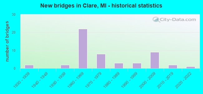
- New bridges - historical statistics
- 21930-1939
- 21950-1959
- 221960-1969
- 81970-1979
- 31980-1989
- 31990-1999
- 92000-2009
- 22010-2019
- 12020-2022

- Reconstructed bridges - Historical Statistics
- 21980-1989
- 11990-1999
- 02000-2009
- 12010-2019


- Bridge Condition - Deck
- 3.6%Very good
- 39.3%Good
- 46.4%Satisfactory
- 10.7%Fair

- Bridge Condition - Superstructure
- 7.1%Very good
- 25.0%Good
- 53.6%Satisfactory
- 14.3%Fair

- Bridge Condition - Substructure
- 21.4%Very good
- 39.3%Good
- 32.1%Satisfactory
- 3.6%Fair
- 3.6%Poor

- Bridge Condition - Channel
- 5.9%Excellent
- 11.8%Very good
- 47.1%Good
- 35.3%Satisfactory

- Bridge Condition - Culverts
- 16.7%Excellent
- 16.7%Very good
- 33.3%Good
- 16.7%Satisfactory
- 16.7%Serious
Find on map >> Show street view
Structure Number: 17, Location: 1 MI S OF MIKADO (Lat: 44.578261, Lng: -83.422322), Route carried "on" structure: County highway 167, Year Built: 1956, Status: Open, Structure Length: 1.22m (4.00ft), Average Daily Traffic: 2,770 (year 2003), Truck Traffic: 8%, Average Future Daily Traffic: 3,740 (year 2023), Design Load: H 20, Features Intersected: VAN ETTEN CREEK, Facility Carried by Structure: COUNTY HWY F41
Minimum Vertical Clearance: 30.48m (100.00ft), Kilometerpoint: 7.400, Lanes on structure: 2, Owner: County Highway Agency, Approaching Roadway Width: 11.0m (36.1ft), Skew: 3 degrees, Material/Design: Concrete continuous, Design/Construction: Culvert, Number Of Spans In Main Unit: 2, Length of Maximum Span: 5.1m (16.7ft), Curb or Sidewalk Widths: Left: 0.2m (0.7ft), Right: 0.2m (0.7ft), Curb-To-Curb Width: 11.9m (39.0ft), Out-to-Out Width: 13.2m (43.3ft)
Condition: Channel: Satisfactory, Culverts: Satisfactory, Operating Rating: 55.2 metric tons, Method Used To Determine Operating Rating: Allowable Stress (AS), Inventory Rating: 35.2 metric tons, Method Used To Determine Inventory Rating: Allowable Stress (AS), Structural Evaluation: Equal to present minimum criteria, Deck Geometry: Somewhat better than minimum adequacy, Waterway Adequacy: Equal to present desirable criteria, Approach Roadway Alignment: Equal to present desirable criteria, Designated Inspection Frequency: Every 24 months, Inspection Date: May 2021, Deck Structure Type: Concrete Cast-file-Place, Wearing Surface/Protective System: Wearing Surface: Bituminous
Find on map >> Show street view
Structure Number: 1684, Location: 1.9 MI W OF CLARE (Lat: 43.827144, Lng: -84.805992), Route carried "on" structure: State highway 115, Year Built: 1935, Year Reconstructed: 1989, Status: Open, Structure Length: 1.55m (5.09ft), Average Daily Traffic: 7,472 (year 2007), Truck Traffic: 3%, Average Future Daily Traffic: 10,808 (year 2018), Design Load: H 20, Features Intersected: S BR TOBACCO RIVER
Minimum Vertical Clearance: 30.48m (100.00ft), Kilometerpoint: 24.593, Lanes on structure: 2, Owner: State Highway Agency, Approaching Roadway Width: 12.2m (40.0ft), Material/Design: Steel, Design/Construction: Stringer/Multi-beam, Number Of Spans In Main Unit: 1, Length of Maximum Span: 15.5m (50.9ft), Curb-To-Curb Width: 13.4m (44.0ft), Out-to-Out Width: 14.3m (46.9ft)
Condition: Deck: Satisfactory, Superstructure: Satisfactory, Substructure: Satisfactory, Channel: Good, Operating Rating: 95.6 metric tons, Method Used To Determine Operating Rating: Load Factor (LF) rating reported by rating factor (RF) method using MS18 loading, Inventory Rating: 57.3 metric tons, Method Used To Determine Inventory Rating: Load Factor (LF) rating reported by rating factor (RF) method using MS18 loading, Structural Evaluation: Equal to present minimum criteria, Deck Geometry: Equal to present minimum criteria, Waterway Adequacy: Equal to present desirable criteria, Approach Roadway Alignment: Somewhat better than minimum adequacy, Designated Inspection Frequency: Every 24 months, Inspection Date: September 2020, Deck Structure Type: Concrete Cast-file-Place, Wearing Surface/Protective System: Wearing Surface: Latex Concrete, Deck Protection: Epoxy Coated Reinforcing
Find on map >> Show street view
Structure Number: 1686, Location: 0.4 MI SE OF US-127 (Lat: 43.821597, Lng: -84.742722), Route carried "on" structure: US 10, Year Built: 2019, Status: Open, Structure Length: 0.67m (2.20ft), Average Daily Traffic: 5,400 (year 2015), Truck Traffic: 14%, Average Future Daily Traffic: 6,210 (year 2035), Design Load: Greater than HL93, Features Intersected: LITTLE TOBACCO DRAIN
Minimum Vertical Clearance: 30.48m (100.00ft), Kilometerpoint: 0.678, Lanes on structure: 2, Base Highway Network: Yes (Inventory Route: 104, Subroute: 4), Owner: State Highway Agency, Approaching Roadway Width: 13.0m (42.7ft), Material/Design: Concrete, Design/Construction: Culvert, Number Of Spans In Main Unit: 1, Length of Maximum Span: 6.7m (22.0ft), Curb or Sidewalk Widths: Left: 0.6m (2.0ft), Right: 0.6m (2.0ft), Curb-To-Curb Width: 13.0m (42.7ft), Out-to-Out Width: 34.1m (111.9ft)
Condition: Channel: Very good, Culverts: Very good, Operating Rating: 97.2 metric tons, Method Used To Determine Operating Rating: Load and Resistance Factor Rating (LRFR) rating reported by rating factor(RF) method using HL-93 loadings, Inventory Rating: 97.2 metric tons, Method Used To Determine Inventory Rating: Load and Resistance Factor Rating (LRFR) rating reported by rating factor(RF) method using HL-93 loadings, Structural Evaluation: Equal to present desirable criteria, Deck Geometry: Superior to present desirable criteria, Waterway Adequacy: Better than present minimum criteria, Approach Roadway Alignment: Equal to present minimum criteria, Designated Inspection Frequency: Every 24 months, Inspection Date: September 2020, Wearing Surface/Protective System: Wearing Surface: Low Slump Concrete
Find on map >> Show street view
Structure Number: 1687, Location: 0.4 MI SE OF US-127 (Lat: 43.822750, Lng: -84.743358), Route carried "on" structure: US 10, Year Built: 2019, Status: Open, Structure Length: 0.70m (2.30ft), Average Daily Traffic: 5,400 (year 2015), Truck Traffic: 14%, Average Future Daily Traffic: 6,210 (year 2035), Design Load: Greater than HL93, Features Intersected: LITTLE TOBACCO DRAIN
Minimum Vertical Clearance: 30.48m (100.00ft), Kilometerpoint: 0.801, Lanes on structure: 2, Base Highway Network: Yes (Inventory Route: 104, Subroute: 5), Owner: State Highway Agency, Approaching Roadway Width: 13.0m (42.7ft), Skew: 1 degrees, Material/Design: Concrete, Design/Construction: Culvert, Number Of Spans In Main Unit: 1, Length of Maximum Span: 7.0m (23.0ft), Curb or Sidewalk Widths: Left: 0.6m (2.0ft), Right: 0.6m (2.0ft), Curb-To-Curb Width: 13.0m (42.7ft), Out-to-Out Width: 40.8m (133.9ft)
Condition: Channel: Very good, Culverts: Good, Operating Rating: 97.2 metric tons, Method Used To Determine Operating Rating: Load and Resistance Factor Rating (LRFR) rating reported by rating factor(RF) method using HL-93 loadings, Inventory Rating: 83.9 metric tons, Method Used To Determine Inventory Rating: Load and Resistance Factor Rating (LRFR) rating reported by rating factor(RF) method using HL-93 loadings, Structural Evaluation: Better than present minimum criteria, Deck Geometry: Superior to present desirable criteria, Waterway Adequacy: Equal to present minimum criteria, Approach Roadway Alignment: Equal to present minimum criteria, Designated Inspection Frequency: Every 24 months, Inspection Date: September 2020, Wearing Surface/Protective System: Wearing Surface: Low Slump Concrete
Find on map >> Show street view
Structure Number: 1688, Location: 0.8 MI NW OF ISABELLA COL (Lat: 43.824792, Lng: -84.748567), Route carried "on" structure: Alternate US 10, Year Built: 1961, Status: Open, Structure Length: 7.25m (23.79ft), Average Daily Traffic: 5,688 (year 2007), Truck Traffic: 19%, Average Future Daily Traffic: 4,352 (year 2018), Design Load: HS 20, Features Intersected: US-127 NB & EBERHART RD
Minimum Vertical Clearance: 30.48m (100.00ft), Kilometerpoint: 0.267, Lanes on structure: 2, Lanes under structure: 4, Base Highway Network: Yes (Inventory Route: 104, Subroute: 4), Owner: State Highway Agency, Approaching Roadway Width: 12.8m (42.0ft), Skew: 3 degrees, Material/Design: Steel, Design/Construction: Stringer/Multi-beam, Number Of Spans In Main Unit: 4, Length of Maximum Span: 22.2m (72.8ft), Curb-To-Curb Width: 9.7m (31.8ft), Out-to-Out Width: 10.9m (35.8ft)
Condition: Deck: Fair, Superstructure: Fair, Substructure: Satisfactory, Operating Rating: 59.6 metric tons, Method Used To Determine Operating Rating: Load Factor (LF) rating reported by rating factor (RF) method using MS18 loading, Inventory Rating: 35.6 metric tons, Method Used To Determine Inventory Rating: Load Factor (LF) rating reported by rating factor (RF) method using MS18 loading, Structural Evaluation: Somewhat better than minimum adequacy, Deck Geometry: Meets minimum limits, Underclear: Equal to present minimum criteria, Approach Roadway Alignment: Equal to present desirable criteria, Designated Inspection Frequency: Every 24 months, Inspection Date: September 2020, Deck Structure Type: Concrete Cast-file-Place, Wearing Surface/Protective System: Wearing Surface: Latex Concrete
Find on map >> Show street view
Structure Number: 169, Location: @ ISABELLA CO LINE (Lat: 43.814956, Lng: -84.731567), Route carried "on" structure: County highway , Year Built: 1961, Status: Open, Structure Length: 8.54m (28.02ft), Average Daily Traffic: 600 (year 2007), Truck Traffic: 5%, Average Future Daily Traffic: 600 (year 2010), Design Load: H 15, Features Intersected: US-10 CONN, Facility Carried by Structure: CLARABELLA RD
Minimum Vertical Clearance: 30.48m (100.00ft), Kilometerpoint: 1.719, Lanes on structure: 2, Lanes under structure: 4, Owner: State Highway Agency, Approaching Roadway Width: 10.3m (33.8ft), Skew: 4 degrees, Material/Design: Steel, Design/Construction: Stringer/Multi-beam, Number Of Spans In Main Unit: 4, Length of Maximum Span: 28.9m (94.8ft), Curb-To-Curb Width: 8.4m (27.6ft), Out-to-Out Width: 9.4m (30.8ft)
Condition: Deck: Good, Superstructure: Fair, Substructure: Good, Operating Rating: 78.7 metric tons, Method Used To Determine Operating Rating: Load Factor (LF) rating reported by rating factor (RF) method using MS18 loading, Inventory Rating: 47.3 metric tons, Method Used To Determine Inventory Rating: Load Factor (LF) rating reported by rating factor (RF) method using MS18 loading, Structural Evaluation: Somewhat better than minimum adequacy, Deck Geometry: Somewhat better than minimum adequacy, Underclear: Somewhat better than minimum adequacy, Approach Roadway Alignment: Equal to present minimum criteria, Designated Inspection Frequency: Every 24 months, Inspection Date: September 2020, Deck Structure Type: Concrete Cast-file-Place, Wearing Surface/Protective System: Wearing Surface: Epoxy Overlay
Find on map >> Show street view
Structure Number: 1697, Location: 5 MI N OF CLARE (Lat: 43.881458, Lng: -84.788103), Route carried "on" structure: County highway , Year Built: 1973, Status: Open, Structure Length: 14.93m (48.98ft), Average Daily Traffic: 300 (year 1996), Truck Traffic: 3%, Average Future Daily Traffic: 500 (year 2010), Design Load: H 20, Features Intersected: US-10, Facility Carried by Structure: GRANT RD
Minimum Vertical Clearance: 30.48m (100.00ft), Kilometerpoint: 7.328, Lanes on structure: 2, Lanes under structure: 4, Owner: State Highway Agency, Approaching Roadway Width: 10.9m (35.8ft), Skew: 1 degrees, Material/Design: Steel, Design/Construction: Stringer/Multi-beam, Number Of Spans In Main Unit: 7, Length of Maximum Span: 28.9m (94.8ft), Curb or Sidewalk Widths: Left: 0.2m (0.7ft), Right: 0.2m (0.7ft), Curb-To-Curb Width: 10.5m (34.4ft), Out-to-Out Width: 11.7m (38.4ft)
Condition: Deck: Satisfactory, Superstructure: Satisfactory, Substructure: Good, Operating Rating: 71.0 metric tons, Method Used To Determine Operating Rating: Load Factor (LF) rating reported by rating factor (RF) method using MS18 loading, Inventory Rating: 42.4 metric tons, Method Used To Determine Inventory Rating: Load Factor (LF) rating reported by rating factor (RF) method using MS18 loading, Structural Evaluation: Equal to present minimum criteria, Deck Geometry: Better than present minimum criteria, Underclear: Better than present minimum criteria, Approach Roadway Alignment: Better than present minimum criteria, Length Of Structure Improvement: 14.94m (49.02ft), Designated Inspection Frequency: Every 24 months, Inspection Date: October 2020, Bridge Improvement Cost: $442,000, Roadway Improvement Cost: $12,000, Total Project Cost: $138,000, Deck Structure Type: Concrete Cast-file-Place, Wearing Surface/Protective System: Wearing Surface: Monolithic Concrete
Find on map >> Show street view
Structure Number: 1698, Location: 4 MI N OF CLARE (Lat: 43.878689, Lng: -84.778419), Route carried "on" structure: US 10, Year Built: 1973, Status: Open, Structure Length: 11.18m (36.68ft), Average Daily Traffic: 9,050 (year 2016), Truck Traffic: 8%, Average Future Daily Traffic: 10,025 (year 2036), Design Load: HS 20, Features Intersected: US-127
Minimum Vertical Clearance: 30.48m (100.00ft), Kilometerpoint: 12.371, Lanes on structure: 2, Lanes under structure: 5, Base Highway Network: Yes (Inventory Route: 318, Subroute: 14), Owner: State Highway Agency, Approaching Roadway Width: 13.7m (44.9ft), Skew: 4 degrees, Material/Design: Steel, Design/Construction: Stringer/Multi-beam, Number Of Spans In Main Unit: 4, Length of Maximum Span: 44.2m (145.0ft), Curb-To-Curb Width: 12.6m (41.3ft), Out-to-Out Width: 13.6m (44.6ft)
Condition: Deck: Satisfactory, Superstructure: Good, Substructure: Good, Operating Rating: 67.7 metric tons, Method Used To Determine Operating Rating: Load Factor (LF) rating reported by rating factor (RF) method using MS18 loading, Inventory Rating: 40.8 metric tons, Method Used To Determine Inventory Rating: Load Factor (LF) rating reported by rating factor (RF) method using MS18 loading, Structural Evaluation: Better than present minimum criteria, Deck Geometry: Better than present minimum criteria, Underclear: Better than present minimum criteria, Approach Roadway Alignment: Better than present minimum criteria, Designated Inspection Frequency: Every 24 months, Inspection Date: October 2020, Deck Structure Type: Concrete Cast-file-Place, Wearing Surface/Protective System: Wearing Surface: Latex Concrete, Deck Protection: Epoxy Coated Reinforcing
Find on map >> Show street view
Structure Number: 1699, Location: 4 MI N OF CLARE (Lat: 43.873175, Lng: -84.778464), Route carried "on" structure: Ramp US 10, Year Built: 1973, Status: Open, Structure Length: 8.81m (28.90ft), Average Daily Traffic: 1,100 (year 1988), Truck Traffic: 16%, Average Future Daily Traffic: 1,265 (year 2008), Design Load: HS 20, Features Intersected: US-127
Minimum Vertical Clearance: 30.48m (100.00ft), Kilometerpoint: 0.917, Lanes on structure: 1, Lanes under structure: 6, Owner: State Highway Agency, Approaching Roadway Width: 10.0m (32.8ft), Skew: 1 degrees, Material/Design: Steel, Design/Construction: Stringer/Multi-beam, Number Of Spans In Main Unit: 4, Length of Maximum Span: 36.5m (119.8ft), Curb-To-Curb Width: 7.7m (25.3ft), Out-to-Out Width: 8.7m (28.5ft)
Condition: Deck: Satisfactory, Superstructure: Satisfactory, Substructure: Satisfactory, Operating Rating: 70.0 metric tons, Method Used To Determine Operating Rating: Load Factor (LF) rating reported by rating factor (RF) method using MS18 loading, Inventory Rating: 41.8 metric tons, Method Used To Determine Inventory Rating: Load Factor (LF) rating reported by rating factor (RF) method using MS18 loading, Structural Evaluation: Equal to present minimum criteria, Deck Geometry: Better than present minimum criteria, Underclear: Better than present minimum criteria, Approach Roadway Alignment: Equal to present minimum criteria, Designated Inspection Frequency: Every 24 months, Inspection Date: October 2020, Deck Structure Type: Concrete Cast-file-Place, Wearing Surface/Protective System: Wearing Surface: Monolithic Concrete
Find on map >> Show street view
Structure Number: 17, Location: IN CLARE (Lat: 43.830114, Lng: -84.768311), Route carried "on" structure: Business US 127, Year Built: 1931, Year Reconstructed: 1991, Status: Open, Structure Length: 1.37m (4.49ft), Average Daily Traffic: 11,391 (year 2007), Truck Traffic: 3%, Average Future Daily Traffic: 17,400 (year 2018), Design Load: HS 25 or greater, Features Intersected: S BR TOBACCO RIVER
Minimum Vertical Clearance: 30.48m (100.00ft), Kilometerpoint: 1.725, Lanes on structure: 4, Owner: State Highway Agency, Approaching Roadway Width: 14.6m (47.9ft), Material/Design: Prestressed concrete, Design/Construction: Box Beam or Girders - Multiple, Number Of Spans In Main Unit: 1, Length of Maximum Span: 13.7m (44.9ft), Curb or Sidewalk Widths: Left: 1.5m (4.9ft), Right: 1.5m (4.9ft), Curb-To-Curb Width: 19.5m (64.0ft), Out-to-Out Width: 23.4m (76.8ft)
Condition: Deck: Satisfactory, Superstructure: Satisfactory, Substructure: Fair, Channel: Good, Operating Rating: 64.8 metric tons, Method Used To Determine Operating Rating: Load Factor (LF) rating reported by rating factor (RF) method using MS18 loading, Inventory Rating: 38.9 metric tons, Method Used To Determine Inventory Rating: Load Factor (LF) rating reported by rating factor (RF) method using MS18 loading, Structural Evaluation: Somewhat better than minimum adequacy, Deck Geometry: Better than present minimum criteria, Waterway Adequacy: Equal to present minimum criteria, Approach Roadway Alignment: Equal to present minimum criteria, Designated Inspection Frequency: Every 24 months, Inspection Date: August 2021, Bridge Improvement Cost: $38,000, Deck Structure Type: Concrete Cast-file-Place, Wearing Surface/Protective System: Wearing Surface: Monolithic Concrete, Deck Protection: Epoxy Coated Reinforcing
Find on map >> Show street view
Structure Number: 1701, Location: (220 MCEWAN ST) CLARE (Lat: 43.816572, Lng: -84.768344), Route carried "on" structure: Business US 127, Year Built: 2021, Status: Open, Structure Length: 0.73m (2.40ft), Average Daily Traffic: 10,224 (year 2007), Truck Traffic: 2%, Average Future Daily Traffic: 14,245 (year 2018), Design Load: Greater than HL93, Features Intersected: LITTLE TOBACCO RIVER
Minimum Vertical Clearance: 30.48m (100.00ft), Kilometerpoint: 0.204, Lanes on structure: 4, Owner: State Highway Agency, Approaching Roadway Width: 20.1m (65.9ft), Material/Design: Concrete, Design/Construction: Culvert, Number Of Spans In Main Unit: 1, Length of Maximum Span: 7.3m (24.0ft), Curb or Sidewalk Widths: Left: 0.6m (2.0ft), Right: 0.6m (2.0ft)
Condition: Channel: Excellent, Culverts: Excellent, Operating Rating: 62.9 metric tons, Method Used To Determine Operating Rating: Load and Resistance Factor Rating (LRFR) rating reported by rating factor(RF) method using HL-93 loadings, Inventory Rating: 48.6 metric tons, Method Used To Determine Inventory Rating: Load and Resistance Factor Rating (LRFR) rating reported by rating factor(RF) method using HL-93 loadings, Structural Evaluation: Superior to present desirable criteria, Waterway Adequacy: Equal to present desirable criteria, Approach Roadway Alignment: Equal to present desirable criteria, Designated Inspection Frequency: Every 7 months, Inspection Date: Febuary 2022, Wearing Surface/Protective System: Wearing Surface: Bituminous
Find on map >> Show street view
Structure Number: 1702, Location: N LTS OF CLARE (Lat: 43.831233, Lng: -84.750150), Route carried "on" structure: US 127, Year Built: 1962, Status: Open, Structure Length: 1.52m (4.99ft), Average Daily Traffic: 9,699 (year 2007), Truck Traffic: 10%, Average Future Daily Traffic: 11,562 (year 2018), Design Load: HS 20, Features Intersected: S BR TOBACCO RIVER
Minimum Vertical Clearance: 30.48m (100.00ft), Kilometerpoint: 1.878, Lanes on structure: 2, Base Highway Network: Yes (Inventory Route: 104, Subroute: 3), Owner: State Highway Agency, Approaching Roadway Width: 12.8m (42.0ft), Material/Design: Prestressed concrete, Design/Construction: Stringer/Multi-beam, Number Of Spans In Main Unit: 1, Length of Maximum Span: 15.2m (49.9ft), Curb-To-Curb Width: 16.8m (55.1ft), Out-to-Out Width: 18.2m (59.7ft)
Condition: Deck: Satisfactory, Superstructure: Satisfactory, Substructure: Good, Channel: Good, Operating Rating: 58.3 metric tons, Method Used To Determine Operating Rating: Load Factor (LF) rating reported by rating factor (RF) method using MS18 loading, Inventory Rating: 35.0 metric tons, Method Used To Determine Inventory Rating: Load Factor (LF) rating reported by rating factor (RF) method using MS18 loading, Structural Evaluation: Equal to present minimum criteria, Deck Geometry: Superior to present desirable criteria, Waterway Adequacy: Equal to present desirable criteria, Approach Roadway Alignment: Better than present minimum criteria, Designated Inspection Frequency: Every 24 months, Inspection Date: October 2020, Deck Structure Type: Concrete Cast-file-Place, Wearing Surface/Protective System: Wearing Surface: Latex Concrete
Find on map >> Show street view
Structure Number: 1703, Location: N LTS OF CLARE (Lat: 43.830994, Lng: -84.751469), Route carried "on" structure: US 127, Year Built: 1962, Year Reconstructed: 2001, Status: Open, Structure Length: 1.52m (4.99ft), Average Daily Traffic: 9,699 (year 2007), Truck Traffic: 5%, Average Future Daily Traffic: 17,315 (year 2020), Design Load: HS 20, Features Intersected: S BR TOBACCO RIVER
Minimum Vertical Clearance: 30.48m (100.00ft), Kilometerpoint: 1.828, Lanes on structure: 2, Base Highway Network: Yes (Inventory Route: 104, Subroute: 8), Owner: State Highway Agency, Approaching Roadway Width: 12.8m (42.0ft), Material/Design: Prestressed concrete, Design/Construction: Stringer/Multi-beam, Number Of Spans In Main Unit: 1, Length of Maximum Span: 15.2m (49.9ft), Curb-To-Curb Width: 17.5m (57.4ft), Out-to-Out Width: 18.7m (61.4ft)
Condition: Deck: Satisfactory, Superstructure: Satisfactory, Substructure: Good, Channel: Satisfactory, Operating Rating: 54.8 metric tons, Method Used To Determine Operating Rating: Load Factor (LF) rating reported by rating factor (RF) method using MS18 loading, Inventory Rating: 33.0 metric tons, Method Used To Determine Inventory Rating: Load Factor (LF) rating reported by rating factor (RF) method using MS18 loading, Structural Evaluation: Equal to present minimum criteria, Deck Geometry: Superior to present desirable criteria, Waterway Adequacy: Equal to present desirable criteria, Approach Roadway Alignment: Better than present minimum criteria, Designated Inspection Frequency: Every 24 months, Inspection Date: October 2020, Deck Structure Type: Concrete Cast-file-Place, Wearing Surface/Protective System: Wearing Surface: Latex Concrete
Find on map >> Show street view
Structure Number: 1706, Location: US-127 BR (Lat: 43.843056, Lng: -84.768217), Route carried "on" structure: US 127, Year Built: 2001, Status: Open, Structure Length: 3.73m (12.24ft), Average Daily Traffic: 10,697 (year 2019), Truck Traffic: 8%, Average Future Daily Traffic: 12,302 (year 2039), Design Load: HS 25 or greater, Features Intersected: US-127 BR
Minimum Vertical Clearance: 30.48m (100.00ft), Kilometerpoint: 3.927, Lanes on structure: 2, Lanes under structure: 2, Base Highway Network: Yes (Inventory Route: 104, Subroute: 3), Owner: State Highway Agency, Approaching Roadway Width: 12.8m (42.0ft), Skew: 14 degrees, Material/Design: Steel, Design/Construction: Stringer/Multi-beam, Number Of Spans In Main Unit: 1, Length of Maximum Span: 37.3m (122.4ft), Curb-To-Curb Width: 19.6m (64.3ft), Out-to-Out Width: 20.6m (67.6ft)
Condition: Deck: Satisfactory, Superstructure: Satisfactory, Substructure: Satisfactory, Operating Rating: 88.8 metric tons, Method Used To Determine Operating Rating: Load Factor (LF) rating reported by rating factor (RF) method using MS18 loading, Inventory Rating: 53.1 metric tons, Method Used To Determine Inventory Rating: Load Factor (LF) rating reported by rating factor (RF) method using MS18 loading, Structural Evaluation: Equal to present minimum criteria, Deck Geometry: Superior to present desirable criteria, Underclear: Equal to present minimum criteria, Approach Roadway Alignment: Equal to present desirable criteria, Designated Inspection Frequency: Every 24 months, Inspection Date: January 2022, Deck Structure Type: Concrete Cast-file-Place, Wearing Surface/Protective System: Wearing Surface: Monolithic Concrete, Deck Protection: Epoxy Coated Reinforcing
Find on map >> Show street view
Structure Number: 1707, Location: US-127 BR (Lat: 43.842692, Lng: -84.768208), Route carried "on" structure: US 127, Year Built: 2001, Status: Open, Structure Length: 3.69m (12.11ft), Average Daily Traffic: 10,697 (year 2019), Truck Traffic: 8%, Average Future Daily Traffic: 12,302 (year 2039), Design Load: HS 25 or greater, Features Intersected: US-127 BR
Minimum Vertical Clearance: 30.48m (100.00ft), Kilometerpoint: 3.800, Lanes on structure: 2, Lanes under structure: 2, Base Highway Network: Yes (Inventory Route: 104, Subroute: 8), Owner: State Highway Agency, Approaching Roadway Width: 12.8m (42.0ft), Skew: 14 degrees, Material/Design: Steel, Design/Construction: Stringer/Multi-beam, Number Of Spans In Main Unit: 1, Length of Maximum Span: 36.9m (121.1ft), Curb-To-Curb Width: 19.6m (64.3ft), Out-to-Out Width: 20.6m (67.6ft)
Condition: Deck: Fair, Superstructure: Satisfactory, Substructure: Satisfactory, Operating Rating: 91.7 metric tons, Method Used To Determine Operating Rating: Load Factor (LF) rating reported by rating factor (RF) method using MS18 loading, Inventory Rating: 54.8 metric tons, Method Used To Determine Inventory Rating: Load Factor (LF) rating reported by rating factor (RF) method using MS18 loading, Structural Evaluation: Equal to present minimum criteria, Deck Geometry: Superior to present desirable criteria, Underclear: Equal to present minimum criteria, Approach Roadway Alignment: Better than present minimum criteria, Designated Inspection Frequency: Every 24 months, Inspection Date: January 2022, Deck Structure Type: Concrete Cast-file-Place, Wearing Surface/Protective System: Wearing Surface: Monolithic Concrete, Deck Protection: Epoxy Coated Reinforcing
Find on map >> Show street view
Structure Number: 1708, Location: 1.0 MI N OF US-127 BR (Lat: 43.856458, Lng: -84.778881), Route carried "on" structure: County highway , Year Built: 1964, Status: Open, Structure Length: 3.75m (12.30ft), Average Daily Traffic: 1,500 (year 1996), Truck Traffic: 3%, Average Future Daily Traffic: 2,500 (year 2010), Design Load: H 15, Features Intersected: US-127 SB, Facility Carried by Structure: SURREY RD
Minimum Vertical Clearance: 30.48m (100.00ft), Kilometerpoint: 9.975, Lanes on structure: 2, Lanes under structure: 2, Owner: State Highway Agency, Approaching Roadway Width: 10.3m (33.8ft), Material/Design: Prestressed concrete, Design/Construction: Stringer/Multi-beam, Number Of Spans In Main Unit: 3, Length of Maximum Span: 17.9m (58.7ft), Curb or Sidewalk Widths: Left: 0.4m (1.3ft), Right: 0.4m (1.3ft), Curb-To-Curb Width: 8.5m (27.9ft), Out-to-Out Width: 10.1m (33.1ft)
Condition: Deck: Good, Superstructure: Good, Substructure: Good, Operating Rating: 74.5 metric tons, Method Used To Determine Operating Rating: Load Factor (LF) rating reported by rating factor (RF) method using MS18 loading, Inventory Rating: 44.7 metric tons, Method Used To Determine Inventory Rating: Load Factor (LF) rating reported by rating factor (RF) method using MS18 loading, Structural Evaluation: Better than present minimum criteria, Deck Geometry: Somewhat better than minimum adequacy, Underclear: Equal to present minimum criteria, Approach Roadway Alignment: Equal to present minimum criteria, Designated Inspection Frequency: Every 24 months, Inspection Date: September 2020, Deck Structure Type: Concrete Cast-file-Place, Wearing Surface/Protective System: Wearing Surface: Monolithic Concrete
Find on map >> Show street view
Structure Number: 1709, Location: 3.0 MI N OF US-127 BR (Lat: 43.887161, Lng: -84.778428), Route carried "on" structure: County highway , Year Built: 1966, Status: Open, Structure Length: 6.25m (20.51ft), Average Daily Traffic: 250 (year 1996), Truck Traffic: 3%, Average Future Daily Traffic: 500 (year 2010), Design Load: H 15, Features Intersected: US-127, Facility Carried by Structure: DOVER RD
Minimum Vertical Clearance: 30.48m (100.00ft), Kilometerpoint: 4.007, Lanes on structure: 2, Lanes under structure: 4, Owner: State Highway Agency, Approaching Roadway Width: 10.3m (33.8ft), Material/Design: Prestressed concrete, Design/Construction: Stringer/Multi-beam, Number Of Spans In Main Unit: 4, Length of Maximum Span: 21.9m (71.9ft), Curb or Sidewalk Widths: Left: 0.4m (1.3ft), Right: 0.4m (1.3ft), Curb-To-Curb Width: 7.9m (25.9ft), Out-to-Out Width: 9.5m (31.2ft)
Condition: Deck: Good, Superstructure: Fair, Substructure: Good, Operating Rating: 62.9 metric tons, Method Used To Determine Operating Rating: Load Factor (LF) rating reported by rating factor (RF) method using MS18 loading, Inventory Rating: 37.6 metric tons, Method Used To Determine Inventory Rating: Load Factor (LF) rating reported by rating factor (RF) method using MS18 loading, Structural Evaluation: Somewhat better than minimum adequacy, Deck Geometry: Somewhat better than minimum adequacy, Underclear: Somewhat better than minimum adequacy, Approach Roadway Alignment: Meets minimum limits, Designated Inspection Frequency: Every 24 months, Inspection Date: October 2020, Deck Structure Type: Concrete Cast-file-Place, Wearing Surface/Protective System: Wearing Surface: Monolithic Concrete
Find on map >> Show street view
Structure Number: 1714, Location: 1.0 MI N OF US-127 BR (Lat: 43.856864, Lng: -84.776550), Route carried "on" structure: County highway , Year Built: 1964, Status: Open, Structure Length: 4.14m (13.58ft), Average Daily Traffic: 1,500 (year 1996), Truck Traffic: 3%, Average Future Daily Traffic: 2,500 (year 2010), Design Load: H 15, Features Intersected: US-127 NB, Facility Carried by Structure: SURREY RD
Minimum Vertical Clearance: 30.48m (100.00ft), Kilometerpoint: 10.171, Lanes on structure: 2, Lanes under structure: 2, Owner: State Highway Agency, Approaching Roadway Width: 10.3m (33.8ft), Skew: 2 degrees, Material/Design: Prestressed concrete, Design/Construction: Stringer/Multi-beam, Number Of Spans In Main Unit: 3, Length of Maximum Span: 19.5m (64.0ft), Curb or Sidewalk Widths: Left: 0.4m (1.3ft), Right: 0.4m (1.3ft), Curb-To-Curb Width: 8.5m (27.9ft), Out-to-Out Width: 10.1m (33.1ft)
Condition: Deck: Good, Superstructure: Satisfactory, Substructure: Satisfactory, Operating Rating: 52.5 metric tons, Method Used To Determine Operating Rating: Load Factor (LF) rating reported by rating factor (RF) method using MS18 loading, Inventory Rating: 31.4 metric tons, Method Used To Determine Inventory Rating: Load Factor (LF) rating reported by rating factor (RF) method using MS18 loading, Structural Evaluation: Equal to present minimum criteria, Deck Geometry: Somewhat better than minimum adequacy, Underclear: Equal to present minimum criteria, Approach Roadway Alignment: Equal to present minimum criteria, Designated Inspection Frequency: Every 24 months, Inspection Date: September 2020, Deck Structure Type: Concrete Cast-file-Place, Wearing Surface/Protective System: Wearing Surface: Monolithic Concrete
Find on map >> Show street view
Structure Number: 174, Location: SHERIDAN TWP SEC 31, 32 (Lat: 43.827597, Lng: -84.706858), Route carried "on" structure: County highway 1879, Year Built: 1990, Status: Open, Structure Length: 2.28m (7.48ft), Average Daily Traffic: 320 (year 2006), Average Future Daily Traffic: 550 (year 2026), Design Load: HS 20+Mod, Features Intersected: SOUTH BR TOBACCO RIVER, Facility Carried by Structure: RODGERS AVENUE
Minimum Vertical Clearance: 30.48m (100.00ft), Kilometerpoint: 1.394, Lanes on structure: 2, Owner: County Highway Agency, Approaching Roadway Width: 9.1m (29.9ft), Skew: 3 degrees, Material/Design: Prestressed concrete, Design/Construction: Box Beam or Girders - Multiple, Number Of Spans In Main Unit: 1, Length of Maximum Span: 22.5m (73.8ft), Curb-To-Curb Width: 9.4m (30.8ft), Out-to-Out Width: 9.4m (30.8ft)
Condition: Deck: Good, Superstructure: Good, Substructure: Very good, Channel: Good, Operating Rating: 62.2 metric tons, Method Used To Determine Operating Rating: Load Factor (LF) rating reported by rating factor (RF) method using MS18 loading, Inventory Rating: 37.3 metric tons, Method Used To Determine Inventory Rating: Load Factor (LF) rating reported by rating factor (RF) method using MS18 loading, Structural Evaluation: Better than present minimum criteria, Deck Geometry: Equal to present minimum criteria, Waterway Adequacy: Superior to present desirable criteria, Approach Roadway Alignment: Superior to present desirable criteria, Designated Inspection Frequency: Every 24 months, Inspection Date: August 2020, Deck Structure Type: Wood or Timber, Wearing Surface/Protective System: Wearing Surface: Bituminous
Find on map >> Show street view
Structure Number: 1758, Location: GRANT TWP SEC 27, 28 (Lat: 43.829714, Lng: -84.788400), Route carried "on" structure: ServiceCounty highway , Year Built: 2001, Status: Open, Structure Length: 1.46m (4.79ft), Average Daily Traffic: 2,000 (year 2006), Average Future Daily Traffic: 3,600 (year 2024), Design Load: HS 20, Features Intersected: S BR TOBACCO RIVER, Facility Carried by Structure: GRANT AVENUE
Minimum Vertical Clearance: 30.48m (100.00ft), Kilometerpoint: 1.677, Lanes on structure: 2, Owner: County Highway Agency, Approaching Roadway Width: 11.3m (37.1ft), Material/Design: Concrete, Design/Construction: Culvert, Number Of Spans In Main Unit: 1, Length of Maximum Span: 14.6m (47.9ft)
Condition: Channel: Satisfactory, Culverts: Good, Operating Rating: 54.5 metric tons, Method Used To Determine Operating Rating: Field evaluation and documented engineering judgment, Inventory Rating: 32.7 metric tons, Method Used To Determine Inventory Rating: Field evaluation and documented engineering judgment, Structural Evaluation: Better than present minimum criteria, Waterway Adequacy: Better than present minimum criteria, Approach Roadway Alignment: Somewhat better than minimum adequacy, Designated Inspection Frequency: Every 24 months, Inspection Date: July 2020, Deck Structure Type: Concrete Cast-file-Place, Wearing Surface/Protective System: Wearing Surface: Bituminous
Find on map >> Show street view
Structure Number: 1759, Location: SEC 36 GRANT TWP (Lat: 43.828900, Lng: -84.748361), Route carried "on" structure: ServiceCounty highway , Year Built: 1993, Status: Open, Structure Length: 1.82m (5.97ft), Average Daily Traffic: 1,380 (year 2006), Average Future Daily Traffic: 2,500 (year 2026), Design Load: HS 20+Mod, Features Intersected: SOUTH BR TOBACCO RIVER, Facility Carried by Structure: EBERHART ROAD
Minimum Vertical Clearance: 30.48m (100.00ft), Kilometerpoint: 0.806, Lanes on structure: 2, Owner: County Highway Agency, Approaching Roadway Width: 9.1m (29.9ft), Material/Design: Prestressed concrete, Design/Construction: Box Beam or Girders - Multiple, Number Of Spans In Main Unit: 1, Length of Maximum Span: 17.0m (55.8ft), Curb-To-Curb Width: 9.8m (32.2ft), Out-to-Out Width: 10.4m (34.1ft)
Condition: Deck: Satisfactory, Superstructure: Good, Substructure: Very good, Channel: Good, Operating Rating: 69.7 metric tons, Method Used To Determine Operating Rating: Load Factor (LF) rating reported by rating factor (RF) method using MS18 loading, Inventory Rating: 36.9 metric tons, Method Used To Determine Inventory Rating: Load Factor (LF) rating reported by rating factor (RF) method using MS18 loading, Structural Evaluation: Better than present minimum criteria, Deck Geometry: Somewhat better than minimum adequacy, Waterway Adequacy: Equal to present desirable criteria, Approach Roadway Alignment: Equal to present minimum criteria, Designated Inspection Frequency: Every 24 months, Inspection Date: July 2020, Deck Structure Type: Concrete Cast-file-Place, Wearing Surface/Protective System: Wearing Surface: Monolithic Concrete, Deck Protection: Epoxy Coated Reinforcing
Find on map >> Show street view
Structure Number: 1767, Location: SEC 30-31 SHERIDAN TWP (Lat: 43.829497, Lng: -84.724967), Route carried "on" structure: ServiceCounty highway , Year Built: 1986, Status: Open, Structure Length: 1.82m (5.97ft), Average Daily Traffic: 380 (year 2006), Average Future Daily Traffic: 690 (year 2026), Design Load: HS 20+Mod, Features Intersected: S BR TOBACCO RIVER, Facility Carried by Structure: WASHINGTON ROAD
Minimum Vertical Clearance: 30.48m (100.00ft), Kilometerpoint: 3.179, Lanes on structure: 2, Owner: County Highway Agency, Approaching Roadway Width: 9.1m (29.9ft), Skew: 1 degrees, Material/Design: Wood or Timber, Design/Construction: Slab, Number Of Spans In Main Unit: 3, Length of Maximum Span: 7.3m (24.0ft), Curb-To-Curb Width: 9.1m (29.9ft), Out-to-Out Width: 9.7m (31.8ft)
Condition: Deck: Good, Superstructure: Good, Substructure: Good, Channel: Satisfactory, Operating Rating: 50.5 metric tons, Method Used To Determine Operating Rating: Allowable Stress (AS) rating reported by rating factor (RF) method using MS18 loading, Inventory Rating: 36.6 metric tons, Method Used To Determine Inventory Rating: Allowable Stress (AS) rating reported by rating factor (RF) method using MS18 loading, Structural Evaluation: Better than present minimum criteria, Deck Geometry: Equal to present minimum criteria, Waterway Adequacy: Better than present minimum criteria, Approach Roadway Alignment: Better than present minimum criteria, Designated Inspection Frequency: Every 24 months, Inspection Date: August 2020, Deck Structure Type: Wood or Timber, Wearing Surface/Protective System: Wearing Surface: Bituminous, Membrane: Preformed Fabric, Deck Protection: Epoxy Coated Reinforcing
Find on map >> Show street view
Structure Number: 1768, Location: SEC 30-31 SHERIDAN TWP (Lat: 43.829478, Lng: -84.708836), Route carried "on" structure: ServiceCounty highway , Year Built: 1992, Status: Open, Structure Length: 2.28m (7.48ft), Average Daily Traffic: 320 (year 2006), Average Future Daily Traffic: 570 (year 2026), Design Load: HS 20, Features Intersected: SOUTH BR TOBACCO RIVER, Facility Carried by Structure: WASHINGTON ROAD
Minimum Vertical Clearance: 30.48m (100.00ft), Kilometerpoint: 1.880, Lanes on structure: 2, Owner: County Highway Agency, Approaching Roadway Width: 9.1m (29.9ft), Skew: 2 degrees, Material/Design: Prestressed concrete, Design/Construction: Box Beam or Girders - Multiple, Number Of Spans In Main Unit: 1, Length of Maximum Span: 21.6m (70.9ft), Curb-To-Curb Width: 9.1m (29.9ft), Out-to-Out Width: 9.4m (30.8ft)
Condition: Deck: Satisfactory, Superstructure: Satisfactory, Substructure: Very good, Channel: Good, Operating Rating: 62.2 metric tons, Method Used To Determine Operating Rating: Load Factor (LF) rating reported by rating factor (RF) method using MS18 loading, Inventory Rating: 37.3 metric tons, Method Used To Determine Inventory Rating: Load Factor (LF) rating reported by rating factor (RF) method using MS18 loading, Structural Evaluation: Equal to present minimum criteria, Deck Geometry: Equal to present minimum criteria, Waterway Adequacy: Equal to present minimum criteria, Approach Roadway Alignment: Equal to present minimum criteria, Designated Inspection Frequency: Every 24 months, Inspection Date: August 2020, Deck Structure Type: Concrete Precast Panels, Wearing Surface/Protective System: Wearing Surface: Bituminous
Find on map >> Show street view
Structure Number: 177, Location: SEC 31 SHERIDAN TWP (Lat: 43.827161, Lng: -84.728267), Route carried "on" structure: ServiceCounty highway , Year Built: 1988, Status: Open, Structure Length: 1.82m (5.97ft), Average Daily Traffic: 320 (year 2006), Average Future Daily Traffic: 570 (year 2026), Design Load: HS 20+Mod, Features Intersected: SOUTH BR TOBACCO RIVER, Facility Carried by Structure: CORNWELL AVENUE
Minimum Vertical Clearance: 30.48m (100.00ft), Kilometerpoint: 1.352, Lanes on structure: 2, Owner: County Highway Agency, Approaching Roadway Width: 9.1m (29.9ft), Skew: 1 degrees, Material/Design: Wood or Timber, Design/Construction: Slab, Number Of Spans In Main Unit: 3, Length of Maximum Span: 7.3m (24.0ft), Curb-To-Curb Width: 9.1m (29.9ft), Out-to-Out Width: 9.7m (31.8ft)
Condition: Deck: Good, Superstructure: Good, Substructure: Good, Channel: Satisfactory, Operating Rating: 49.9 metric tons, Method Used To Determine Operating Rating: Allowable Stress (AS) rating reported by rating factor (RF) method using MS18 loading, Inventory Rating: 36.3 metric tons, Method Used To Determine Inventory Rating: Allowable Stress (AS) rating reported by rating factor (RF) method using MS18 loading, Structural Evaluation: Better than present minimum criteria, Deck Geometry: Equal to present minimum criteria, Waterway Adequacy: Better than present minimum criteria, Approach Roadway Alignment: Better than present minimum criteria, Designated Inspection Frequency: Every 24 months, Inspection Date: August 2020, Deck Structure Type: Wood or Timber, Wearing Surface/Protective System: Wearing Surface: Bituminous, Membrane: Preformed Fabric, Deck Protection: Epoxy Coated Reinforcing
Find on map >> Show street view
Structure Number: 1781, Location: CITY OF CLARE (Lat: 43.828289, Lng: -84.778483), Route carried "on" structure: County highway , Year Built: 1975, Year Reconstructed: 2017, Status: Open, Structure Length: 0.79m (2.59ft), Average Daily Traffic: 189 (year 1988), Truck Traffic: 2%, Average Future Daily Traffic: 209 (year 2007), Design Load: H 20, Features Intersected: SOUTH BR TOBACCO RIVER, Facility Carried by Structure: WOODLAWN STREET
Minimum Vertical Clearance: 30.48m (100.00ft), Kilometerpoint: 0.488, Lanes on structure: 2, Owner: City or Municipal Highway Agency, Approaching Roadway Width: 8.5m (27.9ft), Material/Design: Wood or Timber, Design/Construction: Slab, Number Of Spans In Main Unit: 1, Length of Maximum Span: 7.6m (24.9ft), Curb-To-Curb Width: 7.9m (25.9ft), Out-to-Out Width: 8.3m (27.2ft)
Condition: Deck: Very good, Superstructure: Good, Substructure: Good, Channel: Good, Operating Rating: 39.9 metric tons, Method Used To Determine Operating Rating: Load and Resistance Factor Rating (LRFR) rating reported by rating factor(RF) method using HL-93 loadings, Inventory Rating: 30.8 metric tons, Method Used To Determine Inventory Rating: Load and Resistance Factor Rating (LRFR) rating reported by rating factor(RF) method using HL-93 loadings, Structural Evaluation: Better than present minimum criteria, Deck Geometry: Somewhat better than minimum adequacy, Waterway Adequacy: Better than present minimum criteria, Approach Roadway Alignment: Better than present minimum criteria, Length Of Structure Improvement: 1.48m (4.86ft), Designated Inspection Frequency: Every 24 months, Inspection Date: September 2021, Bridge Improvement Cost: $235,000, Roadway Improvement Cost: $10,000, Total Project Cost: $277,000, Deck Structure Type: Wood or Timber, Wearing Surface/Protective System: Wearing Surface: Bituminous
Find on map >> Show street view
Structure Number: 3997, Location: S LTS OF PORTLAND (Lat: 42.860403, Lng: -84.891344), Route carried "on" structure: Interstate 96, Year Built: 1959, Status: Open, Structure Length: 3.32m (10.89ft), Average Daily Traffic: 20,074 (year 2007), Truck Traffic: 15%, Average Future Daily Traffic: 19,274 (year 2018), Design Load: HS 20, Features Intersected: CHARLOTTE HWY
Minimum Vertical Clearance: 30.48m (100.00ft), Kilometerpoint: 35.009, Lanes on structure: 3, Lanes under structure: 2, Base Highway Network: Yes (Inventory Route: 50, Subroute: 6), Owner: State Highway Agency, Approaching Roadway Width: 12.8m (42.0ft), Skew: 10 degrees, Material/Design: Concrete continuous, Design/Construction: Tee Beam, Number Of Spans In Main Unit: 3, Length of Maximum Span: 12.8m (42.0ft), Curb-To-Curb Width: 15.8m (51.8ft), Out-to-Out Width: 17.5m (57.4ft)
Condition: Deck: Satisfactory, Superstructure: Satisfactory, Substructure: Satisfactory, Operating Rating: 63.8 metric tons, Method Used To Determine Operating Rating: Load Factor (LF) rating reported by rating factor (RF) method using MS18 loading, Inventory Rating: 38.6 metric tons, Method Used To Determine Inventory Rating: Load Factor (LF) rating reported by rating factor (RF) method using MS18 loading, Structural Evaluation: Equal to present minimum criteria, Deck Geometry: Somewhat better than minimum adequacy, Underclear: Meets minimum limits, Approach Roadway Alignment: Better than present minimum criteria, Designated Inspection Frequency: Every 24 months, Inspection Date: December 2020, Deck Structure Type: Concrete Cast-file-Place, Wearing Surface/Protective System: Wearing Surface: Latex Concrete
Find on map >> Show street view
Structure Number: 4251, Location: @ US-10 (Lat: 43.813811, Lng: -84.752806), Route carried "on" structure: US 127, Year Built: 2006, Status: Open, Structure Length: 3.68m (12.07ft), Average Daily Traffic: 6,302 (year 2007), Truck Traffic: 14%, Average Future Daily Traffic: 13,700 (year 2030), Design Load: HS 25 or greater, Features Intersected: US-10 BR
Minimum Vertical Clearance: 30.48m (100.00ft), Kilometerpoint: 42.266, Lanes on structure: 2, Lanes under structure: 2, Base Highway Network: Yes (Inventory Route: 24, Subroute: 3), Owner: State Highway Agency, Approaching Roadway Width: 12.8m (42.0ft), Skew: 11 degrees, Material/Design: Prestressed concrete, Design/Construction: Stringer/Multi-beam, Number Of Spans In Main Unit: 1, Length of Maximum Span: 35.3m (115.8ft), Curb-To-Curb Width: 16.8m (55.1ft), Out-to-Out Width: 17.8m (58.4ft)
Condition: Deck: Good, Superstructure: Very good, Substructure: Very good, Operating Rating: 74.0 metric tons, Method Used To Determine Operating Rating: Load Factor (LF), Inventory Rating: 45.4 metric tons, Method Used To Determine Inventory Rating: Load Factor (LF), Structural Evaluation: Equal to present desirable criteria, Deck Geometry: Superior to present desirable criteria, Underclear: Superior to present desirable criteria, Approach Roadway Alignment: Equal to present desirable criteria, Designated Inspection Frequency: Every 24 months, Inspection Date: Febuary 2022, Deck Structure Type: Concrete Cast-file-Place, Wearing Surface/Protective System: Wearing Surface: Monolithic Concrete, Deck Protection: Epoxy Coated Reinforcing
Find on map >> Show street view
Structure Number: 4252, Location: @ US-10 (Lat: 43.813914, Lng: -84.753150), Route carried "on" structure: US 127, Year Built: 2006, Status: Open, Structure Length: 3.68m (12.07ft), Average Daily Traffic: 6,302 (year 2007), Truck Traffic: 13%, Average Future Daily Traffic: 7,644 (year 2018), Design Load: HS 25 or greater, Features Intersected: US-10 BR
Minimum Vertical Clearance: 30+ m (98+ ft), Kilometerpoint: 42.432, Lanes on structure: 2, Lanes under structure: 2, Base Highway Network: Yes (Inventory Route: 24, Subroute: 6), Owner: State Highway Agency, Approaching Roadway Width: 12.8m (42.0ft), Skew: 11 degrees, Material/Design: Prestressed concrete, Design/Construction: Stringer/Multi-beam, Number Of Spans In Main Unit: 1, Length of Maximum Span: 35.3m (115.8ft), Curb-To-Curb Width: 13.4m (44.0ft), Out-to-Out Width: 14.4m (47.2ft)
Condition: Deck: Good, Superstructure: Very good, Substructure: Very good, Operating Rating: 68.3 metric tons, Method Used To Determine Operating Rating: Load Factor (LF), Inventory Rating: 44.1 metric tons, Method Used To Determine Inventory Rating: Load Factor (LF), Structural Evaluation: Equal to present desirable criteria, Deck Geometry: Superior to present desirable criteria, Underclear: Superior to present desirable criteria, Approach Roadway Alignment: Equal to present desirable criteria, Designated Inspection Frequency: Every 24 months, Inspection Date: Febuary 2022, Deck Structure Type: Concrete Cast-file-Place, Wearing Surface/Protective System: Wearing Surface: Monolithic Concrete, Deck Protection: Epoxy Coated Reinforcing
Find on map >> Show street view
Structure Number: 4259, Location: 4.1 MI S OF US-10 (Lat: 43.756853, Lng: -84.759597), Route carried "on" structure: County highway 3782, Year Built: 1965, Status: Open, Structure Length: 3.90m (12.80ft), Average Daily Traffic: 803 (year 1993), Truck Traffic: 3%, Average Future Daily Traffic: 480 (year 1977), Design Load: H 15, Features Intersected: US-127 SB, Facility Carried by Structure: COLEMAN RD
Minimum Vertical Clearance: 30.48m (100.00ft), Kilometerpoint: 0.652, Lanes on structure: 2, Lanes under structure: 2, Owner: State Highway Agency, Approaching Roadway Width: 10.3m (33.8ft), Skew: 1 degrees, Material/Design: Prestressed concrete, Design/Construction: Stringer/Multi-beam, Number Of Spans In Main Unit: 3, Length of Maximum Span: 18.6m (61.0ft), Curb or Sidewalk Widths: Left: 0.7m (2.3ft), Right: 0.7m (2.3ft), Curb-To-Curb Width: 7.9m (25.9ft), Out-to-Out Width: 10.1m (33.1ft)
Condition: Deck: Good, Superstructure: Satisfactory, Substructure: Very good, Operating Rating: 75.2 metric tons, Method Used To Determine Operating Rating: Load Factor (LF) rating reported by rating factor (RF) method using MS18 loading, Inventory Rating: 38.6 metric tons, Method Used To Determine Inventory Rating: Load Factor (LF) rating reported by rating factor (RF) method using MS18 loading, Structural Evaluation: Equal to present minimum criteria, Deck Geometry: Somewhat better than minimum adequacy, Underclear: Somewhat better than minimum adequacy, Approach Roadway Alignment: Better than present minimum criteria, Designated Inspection Frequency: Every 24 months, Inspection Date: April 2021, Deck Structure Type: Concrete Cast-file-Place, Wearing Surface/Protective System: Wearing Surface: Monolithic Concrete
Find on map >> Show street view
Structure Number: 426, Location: 2.1 MI S OF US-10 (Lat: 43.785781, Lng: -84.758350), Route carried "on" structure: County highway , Year Built: 1964, Status: Open, Structure Length: 6.58m (21.59ft), Average Daily Traffic: 250 (year 1974), Average Future Daily Traffic: 250 (year 1977), Design Load: H 15, Features Intersected: US-127, Facility Carried by Structure: GRASS LAKE RD
Minimum Vertical Clearance: 30.48m (100.00ft), Kilometerpoint: 5.617, Lanes on structure: 2, Lanes under structure: 4, Owner: State Highway Agency, Approaching Roadway Width: 10.9m (35.8ft), Material/Design: Prestressed concrete, Design/Construction: Stringer/Multi-beam, Number Of Spans In Main Unit: 4, Length of Maximum Span: 21.9m (71.9ft), Curb or Sidewalk Widths: Left: 0.7m (2.3ft), Right: 0.7m (2.3ft), Curb-To-Curb Width: 7.3m (24.0ft), Out-to-Out Width: 9.5m (31.2ft)
Condition: Deck: Good, Superstructure: Satisfactory, Substructure: Good, Operating Rating: 56.4 metric tons, Method Used To Determine Operating Rating: Load Factor (LF) rating reported by rating factor (RF) method using MS18 loading, Inventory Rating: 33.7 metric tons, Method Used To Determine Inventory Rating: Load Factor (LF) rating reported by rating factor (RF) method using MS18 loading, Structural Evaluation: Equal to present minimum criteria, Deck Geometry: Somewhat better than minimum adequacy, Underclear: Somewhat better than minimum adequacy, Approach Roadway Alignment: Equal to present desirable criteria, Designated Inspection Frequency: Every 24 months, Inspection Date: April 2021, Deck Structure Type: Concrete Cast-file-Place, Wearing Surface/Protective System: Wearing Surface: Monolithic Concrete
Find on map >> Show street view
Structure Number: 4262, Location: 4.1 MI S OF US-10 (Lat: 43.756864, Lng: -84.757472), Route carried "on" structure: County highway 3782, Year Built: 1965, Status: Open, Structure Length: 3.84m (12.60ft), Average Daily Traffic: 803 (year 1993), Truck Traffic: 3%, Average Future Daily Traffic: 480 (year 1977), Design Load: H 15, Features Intersected: US-127 NB, Facility Carried by Structure: COLEMAN RD
Minimum Vertical Clearance: 30.48m (100.00ft), Kilometerpoint: 0.822, Lanes on structure: 2, Lanes under structure: 2, Owner: State Highway Agency, Approaching Roadway Width: 10.3m (33.8ft), Material/Design: Prestressed concrete, Design/Construction: Stringer/Multi-beam, Number Of Spans In Main Unit: 3, Length of Maximum Span: 17.9m (58.7ft), Curb or Sidewalk Widths: Left: 0.7m (2.3ft), Right: 0.7m (2.3ft), Curb-To-Curb Width: 7.9m (25.9ft), Out-to-Out Width: 10.1m (33.1ft)
Condition: Deck: Satisfactory, Superstructure: Satisfactory, Substructure: Satisfactory, Operating Rating: 80.0 metric tons, Method Used To Determine Operating Rating: Load Factor (LF) rating reported by rating factor (RF) method using MS18 loading, Inventory Rating: 44.1 metric tons, Method Used To Determine Inventory Rating: Load Factor (LF) rating reported by rating factor (RF) method using MS18 loading, Structural Evaluation: Equal to present minimum criteria, Deck Geometry: Somewhat better than minimum adequacy, Underclear: Somewhat better than minimum adequacy, Approach Roadway Alignment: Better than present minimum criteria, Designated Inspection Frequency: Every 24 months, Inspection Date: April 2021, Deck Structure Type: Concrete Cast-file-Place, Wearing Surface/Protective System: Wearing Surface: Monolithic Concrete
Find on map >> Show street view
Structure Number: 4272, Location: 1.4 MI SE OF CLARE COL (Lat: 43.808542, Lng: -84.722175), Route carried "on" structure: US 10, Year Built: 1962, Status: Open, Structure Length: 4.60m (15.09ft), Average Daily Traffic: 5,688 (year 2007), Truck Traffic: 19%, Average Future Daily Traffic: 8,704 (year 2018), Design Load: HS 20+Mod, Features Intersected: US-10 WB RAMP
Minimum Vertical Clearance: 30.48m (100.00ft), Kilometerpoint: 1.080, Lanes on structure: 2, Lanes under structure: 1, Base Highway Network: Yes (Inventory Route: 24, Subroute: 4), Owner: State Highway Agency, Approaching Roadway Width: 13.4m (44.0ft), Skew: 4 degrees, Material/Design: Steel, Design/Construction: Stringer/Multi-beam, Number Of Spans In Main Unit: 3, Length of Maximum Span: 16.1m (52.8ft), Curb-To-Curb Width: 12.8m (42.0ft), Out-to-Out Width: 14.3m (46.9ft)
Condition: Deck: Fair, Superstructure: Satisfactory, Substructure: Satisfactory, Operating Rating: 59.6 metric tons, Method Used To Determine Operating Rating: Load Factor (LF) rating reported by rating factor (RF) method using MS18 loading, Inventory Rating: 35.6 metric tons, Method Used To Determine Inventory Rating: Load Factor (LF) rating reported by rating factor (RF) method using MS18 loading, Structural Evaluation: Equal to present minimum criteria, Deck Geometry: Somewhat better than minimum adequacy, Underclear: Meets minimum limits, Approach Roadway Alignment: Equal to present desirable criteria, Designated Inspection Frequency: Every 24 months, Inspection Date: October 2021, Deck Structure Type: Concrete Cast-file-Place, Wearing Surface/Protective System: Wearing Surface: Latex Concrete
Find on map >> Show street view
Structure Number: 13734, Location: 0.2 MI S OF ALLEN RD (Lat: 43.635619, Lng: -83.604514), Route carried "on" structure: State lands road , Year Built: 1980, Status: Posted for load, Structure Length: 2.08m (6.82ft), Average Daily Traffic: 5 (year 2013), Average Future Daily Traffic: 6 (year 2033), Features Intersected: NW OUTLET NO. 3, Facility Carried by Structure: DRV OFF GARNER RD
Minimum Vertical Clearance: 30.48m (100.00ft), Kilometerpoint: 0.000, Lanes on structure: 1, Owner: State Agenciy, Approaching Roadway Width: 5.1m (16.7ft), Material/Design: Steel, Design/Construction: Stringer/Multi-beam, Number Of Spans In Main Unit: 2, Length of Maximum Span: 13.4m (44.0ft), Curb-To-Curb Width: 5.5m (18.0ft), Out-to-Out Width: 7.3m (24.0ft)
Condition: Deck: Satisfactory, Superstructure: Fair, Substructure: Poor, Channel: Good, Operating Rating: 27.9 metric tons, Method Used To Determine Operating Rating: Load and Resistance Factor Rating (LRFR) rating reported by rating factor(RF) method using HL-93 loadings, Inventory Rating: 21.7 metric tons, Method Used To Determine Inventory Rating: Load and Resistance Factor Rating (LRFR) rating reported by rating factor(RF) method using HL-93 loadings, Structural Evaluation: Meets minimum limits, Deck Geometry: Meets minimum limits, Waterway Adequacy: Better than present minimum criteria, Approach Roadway Alignment: Better than present minimum criteria, Bridge Posting: Required (Relationship of Operating Rating to Maximum Legal Load: 20.0 - 29.9% below), Designated Inspection Frequency: Every 24 months, Inspection Date: July 2021, Deck Structure Type: Concrete Cast-file-Place, Wearing Surface/Protective System: Wearing Surface: Monolithic Concrete
Find on map >> Show street view
Structure Number: 13934, Location: COMMERCE TWP SEC 10 (Lat: 42.593611, Lng: -83.485278), Route carried "on" structure: County highway , Year Built: 1970, Status: Posted for load, Structure Length: 0.64m (2.10ft), Average Daily Traffic: 500 (year 2016), Truck Traffic: 1%, Average Future Daily Traffic: 575 (year 2036), Design Load: HS 20, Features Intersected: HURON RIVER, Facility Carried by Structure: FARR STREET
Minimum Vertical Clearance: 30.48m (100.00ft), Kilometerpoint: 0.475, Lanes on structure: 2, Owner: County Highway Agency, Approaching Roadway Width: 6.7m (22.0ft), Material/Design: Steel, Design/Construction: Culvert, Number Of Spans In Main Unit: 2, Length of Maximum Span: 2.9m (9.5ft), Curb-To-Curb Width: 8.5m (27.9ft), Out-to-Out Width: 9.1m (29.9ft)
Condition: Channel: Satisfactory, Culverts: Serious, Operating Rating: 17.8 metric tons, Method Used To Determine Operating Rating: Load Factor (LF) rating reported by rating factor (RF) method using MS18 loading, Inventory Rating: 10.7 metric tons, Method Used To Determine Inventory Rating: Load Factor (LF) rating reported by rating factor (RF) method using MS18 loading, Structural Evaluation: High priority of corrective action, Deck Geometry: Somewhat better than minimum adequacy, Waterway Adequacy: Better than present minimum criteria, Approach Roadway Alignment: Better than present minimum criteria, Bridge Posting: Required (Relationship of Operating Rating to Maximum Legal Load: 30.0 - 39.9% below), Designated Inspection Frequency: Every 12 months, Inspection Date: June 2021, Wearing Surface/Protective System: Wearing Surface: Gravel
Find on map >> Show street view
Structure Number: 1688, Location: 0.8 MI NW OF ISABELLA COL (Lat: 43.824792, Lng: -84.748567), Route carried "under" structure: US 127, Year Built: 1961, Structure Length: 0. m, Average Daily Traffic: 12,604 (year 2007), Truck Traffic: 13%, Features Intersected: US-127 NB & EBERHART RD
Minimum Vertical Clearance: 4.57m (14.99ft), Kilometerpoint: 1.160, Lanes on structure: 2, Lanes under structure: 4, Material/Design: Steel, Design/Construction: Stringer/Multi-beam, Length of Maximum Span: 22.2m (72.8ft)
Find on map >> Show street view
Structure Number: 1689, Location: 0.9 MI NW OF ISABELLA COL (Lat: 43.825817, Lng: -84.747703), Route carried "under" structure: County highway , Year Built: 1961, Structure Length: 0. m, Average Daily Traffic: 1,000 (year 1996), Truck Traffic: 3%, Features Intersected: EBERHART ROAD, Facility Carried by Structure: US-10 WB
Minimum Vertical Clearance: 4.62m (15.16ft), Kilometerpoint: 1.239, Lanes on structure: 2, Lanes under structure: 2, Material/Design: Steel, Design/Construction: Stringer/Multi-beam, Length of Maximum Span: 17.0m (55.8ft)
Find on map >> Show street view
Structure Number: 169, Location: @ ISABELLA CO LINE (Lat: 43.814956, Lng: -84.731567), Route carried "under" structure: Business US 10, Year Built: 1961, Structure Length: 0. m, Average Daily Traffic: 3,900 (year 2010), Truck Traffic: 12%, Features Intersected: US-10 CONN, Facility Carried by Structure: CLARABELLA RD
Minimum Vertical Clearance: 4.90m (16.08ft), Kilometerpoint: 2.017, Lanes on structure: 2, Lanes under structure: 4, Material/Design: Steel, Design/Construction: Stringer/Multi-beam, Length of Maximum Span: 28.9m (94.8ft)
Find on map >> Show street view
Structure Number: 1697, Location: 5 MI N OF CLARE (Lat: 43.881458, Lng: -84.788103), Route carried "under" structure: US 10, Year Built: 1973, Structure Length: 0. m, Average Daily Traffic: 10,190 (year 2007), Truck Traffic: 9%, Features Intersected: US-10, Facility Carried by Structure: GRANT RD
Minimum Vertical Clearance: 5.82m (19.09ft), Kilometerpoint: 11.985, Lanes on structure: 2, Lanes under structure: 4, Material/Design: Steel, Design/Construction: Stringer/Multi-beam, Length of Maximum Span: 28.9m (94.8ft)
Find on map >> Show street view
Structure Number: 1698, Location: 4 MI N OF CLARE (Lat: 43.878689, Lng: -84.778419), Route carried "under" structure: US 127, Year Built: 1973, Structure Length: 0. m, Average Daily Traffic: 12,138 (year 2007), Truck Traffic: 10%, Features Intersected: US-127, Facility Carried by Structure: US-10 WB
Minimum Vertical Clearance: 5.26m (17.26ft), Kilometerpoint: 8.082, Lanes on structure: 2, Lanes under structure: 5, Material/Design: Steel, Design/Construction: Stringer/Multi-beam, Length of Maximum Span: 44.2m (145.0ft)
Find on map >> Show street view
Structure Number: 1699, Location: 4 MI N OF CLARE (Lat: 43.873175, Lng: -84.778464), Route carried "under" structure: US 127, Year Built: 1973, Structure Length: 0. m, Average Daily Traffic: 22,936 (year 2007), Truck Traffic: 9%, Features Intersected: US-127
Minimum Vertical Clearance: 5.21m (17.09ft), Kilometerpoint: 7.471, Lanes on structure: 1, Lanes under structure: 6, Material/Design: Steel, Design/Construction: Stringer/Multi-beam, Length of Maximum Span: 36.5m (119.8ft)
Find on map >> Show street view
Structure Number: 1706, Location: US-127 BR (Lat: 43.843056, Lng: -84.768217), Route carried "under" structure: Business US 127, Year Built: 2001, Structure Length: 0. m, Average Daily Traffic: 11,391 (year 2007), Truck Traffic: 5%, Features Intersected: US-127 BR
Minimum Vertical Clearance: 5.16m (16.93ft), Kilometerpoint: 3.146, Lanes on structure: 2, Lanes under structure: 2, Material/Design: Steel, Design/Construction: Stringer/Multi-beam, Length of Maximum Span: 37.3m (122.4ft)
Find on map >> Show street view
Structure Number: 1707, Location: US-127 BR (Lat: 43.842692, Lng: -84.768208), Route carried "under" structure: Business US 127, Year Built: 2001, Structure Length: 0. m, Average Daily Traffic: 11,391 (year 2007), Truck Traffic: 3%, Features Intersected: US-127 BR
Minimum Vertical Clearance: 5.18m (16.99ft), Kilometerpoint: 3.106, Lanes on structure: 2, Lanes under structure: 2, Material/Design: Steel, Design/Construction: Stringer/Multi-beam, Length of Maximum Span: 36.9m (121.1ft)
Find on map >> Show street view
Structure Number: 1708, Location: 1.0 MI N OF US-127 BR (Lat: 43.856458, Lng: -84.778881), Route carried "under" structure: US 127, Year Built: 1964, Structure Length: 0. m, Average Daily Traffic: 11,468 (year 2007), Truck Traffic: 9%, Features Intersected: US-127 SB, Facility Carried by Structure: SURREY RD
Minimum Vertical Clearance: 4.65m (15.26ft), Kilometerpoint: 5.652, Lanes on structure: 2, Lanes under structure: 2, Material/Design: Prestressed concrete, Design/Construction: Stringer/Multi-beam, Length of Maximum Span: 17.9m (58.7ft)
Find on map >> Show street view
Structure Number: 1709, Location: 3.0 MI N OF US-127 BR (Lat: 43.887161, Lng: -84.778428), Route carried "under" structure: US 127, Year Built: 1966, Structure Length: 0. m, Average Daily Traffic: 12,138 (year 2007), Truck Traffic: 10%, Features Intersected: US-127, Facility Carried by Structure: DOVER RD
Minimum Vertical Clearance: 4.55m (14.93ft), Kilometerpoint: 9.024, Lanes on structure: 2, Lanes under structure: 4, Material/Design: Prestressed concrete, Design/Construction: Stringer/Multi-beam, Length of Maximum Span: 21.9m (71.9ft)
Find on map >> Show street view
Structure Number: 1714, Location: 1.0 MI N OF US-127 BR (Lat: 43.856864, Lng: -84.776550), Route carried "under" structure: US 127, Year Built: 1964, Structure Length: 0. m, Average Daily Traffic: 11,468 (year 2007), Truck Traffic: 9%, Features Intersected: US-127 NB, Facility Carried by Structure: SURREY RD
Minimum Vertical Clearance: 4.55m (14.93ft), Kilometerpoint: 5.649, Lanes on structure: 2, Lanes under structure: 2, Material/Design: Prestressed concrete, Design/Construction: Stringer/Multi-beam, Length of Maximum Span: 19.5m (64.0ft)