Bridge Statistics for Claremore, Oklahoma (OK)
Condition, Traffic, Stress, Structural Evaluation, Project Costs
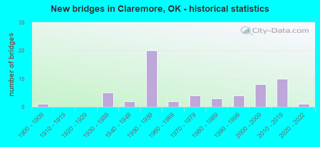
- New bridges - historical statistics
- 11900-1909
- 51930-1939
- 21940-1949
- 201950-1959
- 21960-1969
- 41970-1979
- 31980-1989
- 41990-1999
- 82000-2009
- 102010-2019
- 12020-2022
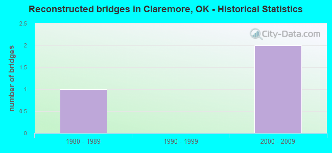
- Reconstructed bridges - Historical Statistics
- 11980-1989
- 01990-1999
- 22000-2009
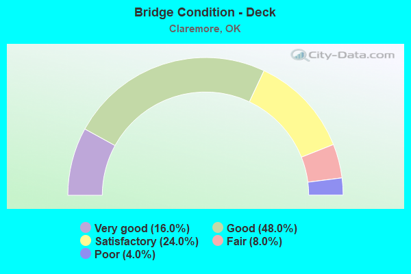
- Bridge Condition - Deck
- 16.0%Very good
- 48.0%Good
- 24.0%Satisfactory
- 8.0%Fair
- 4.0%Poor
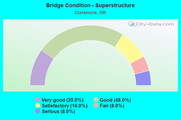
- Bridge Condition - Superstructure
- 20.0%Very good
- 48.0%Good
- 16.0%Satisfactory
- 8.0%Fair
- 8.0%Serious
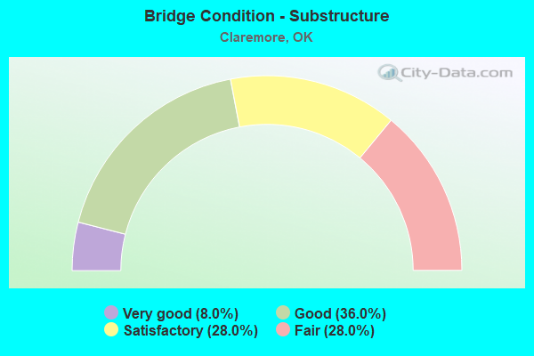
- Bridge Condition - Substructure
- 8.0%Very good
- 36.0%Good
- 28.0%Satisfactory
- 28.0%Fair
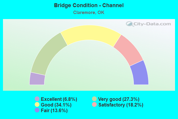
- Bridge Condition - Channel
- 6.8%Excellent
- 27.3%Very good
- 34.1%Good
- 18.2%Satisfactory
- 13.6%Fair
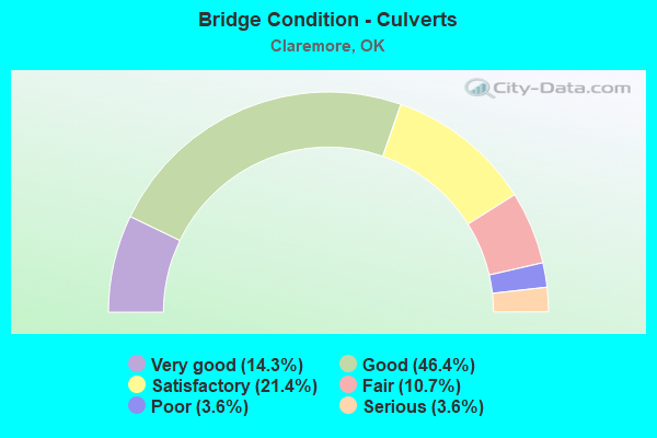
- Bridge Condition - Culverts
- 14.3%Very good
- 46.4%Good
- 21.4%Satisfactory
- 10.7%Fair
- 3.6%Poor
- 3.6%Serious
Find on map >> Show street view
Structure Number: 27802, Location: 2.75E HWY 66&1.5N 1-44 (Lat: 36.351214, Lng: -95.525064), Route carried "on" structure: County highway , Year Built: 2000, Status: Open, Structure Length: 0.73m (2.40ft), Average Daily Traffic: 90 (year 2020), Truck Traffic: 10%, Average Future Daily Traffic: 144 (year 2040), Design Load: HS 20, Features Intersected: DOG CREEK TRIB., Facility Carried by Structure: N4200
Minimum Vertical Clearance: 30+ m (98+ ft), Kilometerpoint: 1.448, Lanes on structure: 2, Owner: County Highway Agency, Approaching Roadway Width: 6.7m (22.0ft), Material/Design: Steel, Design/Construction: Stringer/Multi-beam, Number Of Spans In Main Unit: 1, Length of Maximum Span: 7.3m (24.0ft), Curb-To-Curb Width: 7.3m (24.0ft), Out-to-Out Width: 7.4m (24.3ft)
Condition: Deck: Very good, Superstructure: Good, Substructure: Fair, Channel: Good, Operating Rating: 61.4 metric tons, Method Used To Determine Operating Rating: Load Factor (LF), Inventory Rating: 36.8 metric tons, Method Used To Determine Inventory Rating: Load Factor (LF), Structural Evaluation: Somewhat better than minimum adequacy, Deck Geometry: Equal to present minimum criteria, Waterway Adequacy: Equal to present minimum criteria, Approach Roadway Alignment: Somewhat better than minimum adequacy, Length Of Structure Improvement: 0.80m (2.62ft), Designated Inspection Frequency: Every 24 months, Inspection Date: June 2021, Bridge Improvement Cost: $116,000, Roadway Improvement Cost: $64,000, Total Project Cost: $225,000 ( Estimate for 2016), Deck Structure Type: Concrete Cast-file-Place, Wearing Surface/Protective System: Wearing Surface: Monolithic Concrete
Find on map >> Show street view
Structure Number: 29029, Location: JAY ST .6N OF BLUE STARR (Lat: 36.330178, Lng: -95.614742), Route carried "on" structure: City street N4149, Year Built: 2011, Status: Open, Structure Length: 1.51m (4.95ft), Average Daily Traffic: 1,500 (year 2020), Truck Traffic: 10%, Average Future Daily Traffic: 1,500 (year 2040), Design Load: H 20, Features Intersected: CAT CREEK
Minimum Vertical Clearance: 30+ m (98+ ft), Kilometerpoint: 0.644, Lanes on structure: 2, Owner: City or Municipal Highway Agency, Approaching Roadway Width: 8.4m (27.6ft), Skew: 3 degrees, Material/Design: Concrete, Design/Construction: Culvert, Number Of Spans In Main Unit: 3, Length of Maximum Span: 4.0m (13.1ft), Curb or Sidewalk Widths: Left: 1.8m (5.9ft), Right: 0.0m, Curb-To-Curb Width: 8.0m (26.2ft), Out-to-Out Width: 11.0m (36.1ft)
Condition: Culverts: Satisfactory, Operating Rating: 66.0 metric tons, Method Used To Determine Operating Rating: Load Factor (LF), Inventory Rating: 39.6 metric tons, Method Used To Determine Inventory Rating: Load Factor (LF), Structural Evaluation: Equal to present minimum criteria, Deck Geometry: Meets minimum limits, Waterway Adequacy: Equal to present desirable criteria, Approach Roadway Alignment: Equal to present minimum criteria, Length Of Structure Improvement: 1.31m (4.30ft), Designated Inspection Frequency: Every 24 months, Inspection Date: January 2021, Bridge Improvement Cost: $225,000, Roadway Improvement Cost: $50,000, Total Project Cost: $300,000 ( Estimate for 2015)
Find on map >> Show street view
Structure Number: 29393, Location: 2.3E OF S.H. 66 (Lat: 36.365278, Lng: -95.539142), Route carried "on" structure: County highway E0450, Year Built: 2012, Status: Open, Structure Length: 1.40m (4.59ft), Average Daily Traffic: 2,250 (year 2020), Truck Traffic: 10%, Average Future Daily Traffic: 3,600 (year 2040), Design Load: HS 20, Features Intersected: TRIB TO DOG CREEK
Minimum Vertical Clearance: 30+ m (98+ ft), Kilometerpoint: 0.483, Lanes on structure: 2, Owner: County Highway Agency, Approaching Roadway Width: 10.1m (33.1ft), Material/Design: Concrete, Design/Construction: Culvert, Number Of Spans In Main Unit: 3, Length of Maximum Span: 4.4m (14.4ft)
Condition: Channel: Excellent, Culverts: Very good, Inventory Rating: 64.1 metric tons, Method Used To Determine Inventory Rating: Load Factor (LF), Structural Evaluation: Equal to present desirable criteria, Waterway Adequacy: Equal to present desirable criteria, Approach Roadway Alignment: Equal to present desirable criteria, Designated Inspection Frequency: Every 24 months, Inspection Date: June 2021, Total Project Cost: $225,000
Find on map >> Show street view
Structure Number: 29394, Location: 2.5E OF S.H. 66 (Lat: 36.365297, Lng: -95.537903), Route carried "on" structure: County highway E0450, Year Built: 2012, Status: Open, Structure Length: 3.35m (10.99ft), Average Daily Traffic: 2,250 (year 2020), Truck Traffic: 10%, Average Future Daily Traffic: 3,600 (year 2040), Design Load: HS 20, Features Intersected: DOG CREEK
Minimum Vertical Clearance: 30+ m (98+ ft), Kilometerpoint: 0.805, Lanes on structure: 2, Owner: County Highway Agency, Approaching Roadway Width: 9.4m (30.8ft), Material/Design: Prestressed concrete, Design/Construction: Stringer/Multi-beam, Number Of Spans In Main Unit: 1, Length of Maximum Span: 33.5m (109.9ft), Curb-To-Curb Width: 9.8m (32.2ft), Out-to-Out Width: 10.4m (34.1ft)
Condition: Deck: Good, Superstructure: Very good, Substructure: Very good, Channel: Very good, Inventory Rating: 36.3 metric tons, Method Used To Determine Inventory Rating: Load Factor (LF), Structural Evaluation: Equal to present desirable criteria, Deck Geometry: Meets minimum limits, Waterway Adequacy: Equal to present desirable criteria, Approach Roadway Alignment: Equal to present desirable criteria, Designated Inspection Frequency: Every 24 months, Inspection Date: June 2021, Deck Structure Type: Concrete Cast-file-Place, Wearing Surface/Protective System: Wearing Surface: Monolithic Concrete
Find on map >> Show street view
Structure Number: 30589, Location: .25N OF S.H. 20 (Lat: 36.308889, Lng: -95.435556), Route carried "on" structure: County highway N4250, Year Built: 2011, Status: Open, Structure Length: 1.07m (3.51ft), Average Daily Traffic: 100 (year 2020), Truck Traffic: 10%, Average Future Daily Traffic: 160 (year 2040), Design Load: HS 20, Features Intersected: CHOUTEAU CREEK TRIB.
Minimum Vertical Clearance: 30+ m (98+ ft), Kilometerpoint: 1.448, Lanes on structure: 2, Owner: County Highway Agency, Approaching Roadway Width: 6.4m (21.0ft), Material/Design: Concrete, Design/Construction: Frame, Number Of Spans In Main Unit: 1, Length of Maximum Span: 10.7m (35.1ft), Curb-To-Curb Width: 6.4m (21.0ft), Out-to-Out Width: 6.8m (22.3ft)
Condition: Deck: Very good, Superstructure: Good, Substructure: Very good, Channel: Good, Operating Rating: 78.0 metric tons, Method Used To Determine Operating Rating: Load Factor (LF), Inventory Rating: 46.7 metric tons, Method Used To Determine Inventory Rating: Load Factor (LF), Structural Evaluation: Better than present minimum criteria, Deck Geometry: Somewhat better than minimum adequacy, Waterway Adequacy: Equal to present minimum criteria, Approach Roadway Alignment: Meets minimum limits, Designated Inspection Frequency: Every 24 months, Inspection Date: June 2021, Deck Structure Type: Concrete Cast-file-Place, Wearing Surface/Protective System: Wearing Surface: Bituminous
Find on map >> Show street view
Structure Number: 30695, Location: 1.5E OF S.H. 66 (Lat: 36.321667, Lng: -95.586111), Route carried "on" structure: City street E0480, Year Built: 2012, Status: Open, Structure Length: 0.70m (2.30ft), Average Daily Traffic: 2,500 (year 2020), Truck Traffic: 5%, Average Future Daily Traffic: 4,000 (year 2040), Design Load: HS 20, Features Intersected: DOG CREEK TRIB.
Minimum Vertical Clearance: 30+ m (98+ ft), Kilometerpoint: 1.127, Lanes on structure: 2, Owner: City or Municipal Highway Agency, Approaching Roadway Width: 7.3m (24.0ft), Skew: 3 degrees, Material/Design: Concrete, Design/Construction: Culvert, Number Of Spans In Main Unit: 2, Length of Maximum Span: 3.0m (9.8ft), Curb-To-Curb Width: 8.2m (26.9ft), Out-to-Out Width: 8.8m (28.9ft)
Condition: Channel: Good, Culverts: Good, Operating Rating: 54.5 metric tons, Method Used To Determine Operating Rating: Load Factor (LF), Inventory Rating: 32.7 metric tons, Method Used To Determine Inventory Rating: Load Factor (LF), Structural Evaluation: Better than present minimum criteria, Deck Geometry: High priority of corrective action, Waterway Adequacy: Equal to present minimum criteria, Approach Roadway Alignment: Equal to present desirable criteria, Designated Inspection Frequency: Every 24 months, Inspection Date: January 2021, Total Project Cost: $225,000, Wearing Surface/Protective System: Wearing Surface: Bituminous
Find on map >> Show street view
Structure Number: 30696, Location: .7N OF BLUE STAR RD (Lat: 36.331667, Lng: -95.613889), Route carried "on" structure: City street N4150, Year Built: 2012, Status: Open, Structure Length: 1.51m (4.95ft), Average Daily Traffic: 1,000 (year 2020), Truck Traffic: 5%, Average Future Daily Traffic: 1,600 (year 2040), Design Load: HS 20, Features Intersected: CREEK
Minimum Vertical Clearance: 30+ m (98+ ft), Kilometerpoint: 0.483, Lanes on structure: 2, Owner: City or Municipal Highway Agency, Approaching Roadway Width: 7.9m (25.9ft), Skew: 3 degrees, Material/Design: Concrete, Design/Construction: Culvert, Number Of Spans In Main Unit: 3, Length of Maximum Span: 4.3m (14.1ft), Curb or Sidewalk Widths: Left: 0.0m, Right: 1.8m (5.9ft), Curb-To-Curb Width: 7.9m (25.9ft), Out-to-Out Width: 12.6m (41.3ft)
Condition: Channel: Very good, Culverts: Good, Inventory Rating: 82.0 metric tons, Method Used To Determine Inventory Rating: Load Factor (LF), Structural Evaluation: Better than present minimum criteria, Deck Geometry: Somewhat better than minimum adequacy, Waterway Adequacy: Better than present minimum criteria, Approach Roadway Alignment: Equal to present desirable criteria, Designated Inspection Frequency: Every 24 months, Inspection Date: January 2021, Total Project Cost: $225,000
Find on map >> Show street view
Structure Number: 31386, Location: 1E of WILL ROGERS TP (Lat: 36.350833, Lng: -95.442778), Route carried "on" structure: County highway E0460, Year Built: 1901, Status: Open, Structure Length: 1.04m (3.41ft), Average Daily Traffic: 209 (year 2020), Truck Traffic: 10%, Average Future Daily Traffic: 334 (year 2040), Design Load: H 20, Features Intersected: SEMINOLE CREEK TRIB.
Minimum Vertical Clearance: 30+ m (98+ ft), Kilometerpoint: 1.553, Lanes on structure: 2, Owner: County Highway Agency, Approaching Roadway Width: 7.7m (25.3ft), Material/Design: Concrete, Design/Construction: Culvert, Number Of Spans In Main Unit: 1, Length of Maximum Span: 3.0m (9.8ft)
Condition: Channel: Good, Culverts: Very good, Inventory Rating: 63.5 metric tons, Method Used To Determine Inventory Rating: Load Factor (LF), Structural Evaluation: Equal to present desirable criteria, Waterway Adequacy: Better than present minimum criteria, Approach Roadway Alignment: Equal to present desirable criteria, Designated Inspection Frequency: Every 24 months, Inspection Date: June 2021, Deck Structure Type: Concrete Cast-file-Place
Find on map >> Show street view
Structure Number: 31466, Location: 2N OF TURNPIKE (Lat: 36.362006, Lng: -95.525194), Route carried "on" structure: County highway N4200, Year Built: 2017, Status: Open, Structure Length: 1.31m (4.30ft), Average Daily Traffic: 100 (year 2020), Truck Traffic: 10%, Average Future Daily Traffic: 160 (year 2040), Design Load: HS 20, Features Intersected: CREEK
Minimum Vertical Clearance: 30+ m (98+ ft), Kilometerpoint: 0.483, Lanes on structure: 2, Owner: County Highway Agency, Approaching Roadway Width: 7.9m (25.9ft), Material/Design: Concrete, Design/Construction: Culvert, Number Of Spans In Main Unit: 1, Length of Maximum Span: 12.2m (40.0ft), Curb-To-Curb Width: 9.1m (29.9ft), Out-to-Out Width: 16.2m (53.1ft)
Condition: Channel: Very good, Culverts: Very good, Operating Rating: 47.0 metric tons, Method Used To Determine Operating Rating: Load Factor (LF), Inventory Rating: 28.2 metric tons, Method Used To Determine Inventory Rating: Load Factor (LF), Structural Evaluation: Better than present minimum criteria, Deck Geometry: Better than present minimum criteria, Waterway Adequacy: Better than present minimum criteria, Approach Roadway Alignment: Equal to present desirable criteria, Designated Inspection Frequency: Every 24 months, Inspection Date: June 2021, Total Project Cost: $225,000
Find on map >> Show street view
Structure Number: 31505, Location: .7E OF MAYES C/L (Lat: 36.263969, Lng: -95.448514), Route carried "on" structure: County highway E0520, Year Built: 2016, Status: Open, Structure Length: 1.92m (6.30ft), Average Daily Traffic: 127 (year 2020), Truck Traffic: 15%, Average Future Daily Traffic: 160 (year 2040), Design Load: HL 93, Features Intersected: CREEK
Minimum Vertical Clearance: 30+ m (98+ ft), Kilometerpoint: 0.483, Lanes on structure: 2, Owner: County Highway Agency, Approaching Roadway Width: 7.9m (25.9ft), Material/Design: Concrete, Design/Construction: Culvert, Number Of Spans In Main Unit: 1, Length of Maximum Span: 18.3m (60.0ft), Curb-To-Curb Width: 7.9m (25.9ft), Out-to-Out Width: 10.4m (34.1ft)
Condition: Channel: Very good, Culverts: Satisfactory, Structural Evaluation: Equal to present minimum criteria, Deck Geometry: Somewhat better than minimum adequacy, Waterway Adequacy: Better than present minimum criteria, Approach Roadway Alignment: Equal to present desirable criteria, Designated Inspection Frequency: Every 24 months, Inspection Date: July 2021, Total Project Cost: $225,000
Find on map >> Show street view
Structure Number: 31506, Location: .8S OF E0520 (Lat: 36.256006, Lng: -95.471411), Route carried "on" structure: County highway N4230, Year Built: 2016, Status: Open, Structure Length: 1.31m (4.30ft), Average Daily Traffic: 127 (year 2020), Truck Traffic: 15%, Average Future Daily Traffic: 160 (year 2040), Design Load: HS 20, Features Intersected: CREEK
Minimum Vertical Clearance: 30+ m (98+ ft), Kilometerpoint: 1.287, Lanes on structure: 2, Owner: County Highway Agency, Approaching Roadway Width: 7.9m (25.9ft), Material/Design: Concrete, Design/Construction: Culvert, Number Of Spans In Main Unit: 1, Length of Maximum Span: 12.2m (40.0ft), Curb-To-Curb Width: 7.9m (25.9ft), Out-to-Out Width: 8.8m (28.9ft)
Condition: Channel: Very good, Culverts: Good, Operating Rating: 48.4 metric tons, Method Used To Determine Operating Rating: Load Factor (LF), Inventory Rating: 29.0 metric tons, Method Used To Determine Inventory Rating: Load Factor (LF), Structural Evaluation: Better than present minimum criteria, Deck Geometry: Somewhat better than minimum adequacy, Waterway Adequacy: Equal to present minimum criteria, Approach Roadway Alignment: Equal to present desirable criteria, Designated Inspection Frequency: Every 24 months, Inspection Date: July 2021, Deck Structure Type: Concrete Precast Panels, Wearing Surface/Protective System: Wearing Surface: Integral Concrete
Find on map >> Show street view
Structure Number: 31828, Location: 6SW of US 69 / SH 20 (Lat: 36.270039, Lng: -95.417628), Route carried "on" structure: County highway N4260, Year Built: 2018, Status: Open, Structure Length: 1.32m (4.33ft), Average Daily Traffic: 341 (year 2020), Truck Traffic: 15%, Average Future Daily Traffic: 546 (year 2040), Features Intersected: CREEK
Minimum Vertical Clearance: 30+ m (98+ ft), Kilometerpoint: 1.812, Lanes on structure: 2, Owner: County Highway Agency, Approaching Roadway Width: 7.3m (24.0ft), Material/Design: Concrete, Design/Construction: Culvert, Number Of Spans In Main Unit: 1, Length of Maximum Span: 12.2m (40.0ft), Curb-To-Curb Width: 12.8m (42.0ft), Out-to-Out Width: 13.4m (44.0ft)
Condition: Channel: Very good, Culverts: Very good, Operating Rating: 69.4 metric tons, Method Used To Determine Operating Rating: Load Factor (LF), Inventory Rating: 41.6 metric tons, Method Used To Determine Inventory Rating: Load Factor (LF), Structural Evaluation: Equal to present desirable criteria, Deck Geometry: Superior to present desirable criteria, Waterway Adequacy: Equal to present desirable criteria, Approach Roadway Alignment: Equal to present desirable criteria, Designated Inspection Frequency: Every 24 months, Inspection Date: April 2021, Total Project Cost: $225,000 ( Estimate for 2015)
Find on map >> Show street view
Structure Number: 32868, Location: 0.2W .11 N OF E 510 RD (Lat: 36.280106, Lng: -95.618411), Route carried "on" structure: County highway E0510, Year Built: 2021, Status: Open, Structure Length: 1.04m (3.41ft), Average Daily Traffic: 100 (year 2020), Truck Traffic: 5%, Average Future Daily Traffic: 160 (year 2040), Design Load: H 20, Features Intersected: CREEK, Facility Carried by Structure: S PECAN ST
Minimum Vertical Clearance: 30+ m (98+ ft), Kilometerpoint: 0.259, Lanes on structure: 2, Owner: County Highway Agency, Approaching Roadway Width: 6.2m (20.3ft), Material/Design: Concrete, Design/Construction: Culvert, Number Of Spans In Main Unit: 3, Length of Maximum Span: 3.0m (9.8ft), Curb-To-Curb Width: 6.2m (20.3ft), Out-to-Out Width: 6.2m (20.3ft)
Condition: Channel: Very good, Culverts: Satisfactory, Structural Evaluation: Equal to present minimum criteria, Deck Geometry: Somewhat better than minimum adequacy, Waterway Adequacy: Equal to present desirable criteria, Approach Roadway Alignment: Equal to present desirable criteria, Designated Inspection Frequency: Every 24 months, Inspection Date: July 2021, Deck Structure Type: Concrete Precast Panels
Find on map >> Show street view
Structure Number: 13849, Location: 25.2 MI.NE OF TP GATE (Lat: 36.394733, Lng: -95.421092), Route carried "under" structure: Interstate 44, Year Built: 1957, Structure Length: 0. m, Average Daily Traffic: 16,800 (year 2020), Truck Traffic: 36%, Features Intersected: WILL ROGERS TP I-44 UND, Facility Carried by Structure: CO. RD. E0430
Minimum Vertical Clearance: 4.57m (14.99ft), Kilometerpoint: 2.253, Lanes on structure: 2, Lanes under structure: 4, Toll: On toll road, Material/Design: Steel, Design/Construction: Stringer/Multi-beam, Length of Maximum Span: 13.7m (44.9ft)
Find on map >> Show street view
Structure Number: 13876, Location: 23.9 MI.NE OF TP GATE (Lat: 36.380228, Lng: -95.434531), Route carried "under" structure: Interstate 44, Year Built: 1957, Structure Length: 0. m, Average Daily Traffic: 16,800 (year 2020), Truck Traffic: 36%, Features Intersected: WILL ROGERS TP I-44 UND, Facility Carried by Structure: CO. RD. N4250
Minimum Vertical Clearance: 4.78m (15.68ft), Kilometerpoint: 0.161, Lanes on structure: 2, Lanes under structure: 4, Toll: On toll road, Material/Design: Steel, Design/Construction: Stringer/Multi-beam, Length of Maximum Span: 14.9m (48.9ft)
Find on map >> Show street view
Structure Number: 14131, Location: 19.8 MI.NE OF TP GATE (Lat: 36.342222, Lng: -95.488889), Route carried "under" structure: Interstate 44, Year Built: 1958, Structure Length: 0. m, Average Daily Traffic: 16,800 (year 2020), Truck Traffic: 36%, Features Intersected: WILL ROGERS TP I-44 UND, Facility Carried by Structure: CO. RD. N4220
Minimum Vertical Clearance: 4.60m (15.09ft), Kilometerpoint: 31.215, Lanes on structure: 2, Lanes under structure: 4, Toll: On toll road, Material/Design: Steel, Design/Construction: Stringer/Multi-beam, Length of Maximum Span: 13.1m (43.0ft)
Find on map >> Show street view
Structure Number: 14142, Location: 10.9 MI.NE OF TP GATE (Lat: 36.278889, Lng: -95.623889), Route carried "under" structure: Interstate 44, Year Built: 1958, Structure Length: 0. m, Average Daily Traffic: 23,500 (year 2020), Truck Traffic: 36%, Features Intersected: WILL ROGERS TP I-44 UND, Facility Carried by Structure: CO. RD. E0510
Minimum Vertical Clearance: 4.72m (15.49ft), Kilometerpoint: 16.895, Lanes on structure: 2, Lanes under structure: 4, Toll: On toll road, Material/Design: Steel, Design/Construction: Stringer/Multi-beam, Length of Maximum Span: 13.7m (44.9ft)
Find on map >> Show street view
Structure Number: 14149, Location: 11.6 MI.NE OF TP GATE (Lat: 36.285833, Lng: -95.616667), Route carried "under" structure: Interstate 44, Year Built: 1958, Structure Length: 0. m, Average Daily Traffic: 23,500 (year 2020), Truck Traffic: 36%, Features Intersected: WILL ROGERS TP I-44 UND, Facility Carried by Structure: CO. RD. N4150
Minimum Vertical Clearance: 4.70m (15.42ft), Kilometerpoint: 17.860, Lanes on structure: 2, Lanes under structure: 4, Toll: On toll road, Material/Design: Steel, Design/Construction: Stringer/Multi-beam, Length of Maximum Span: 14.9m (48.9ft)
Find on map >> Show street view
Structure Number: 14153, Location: 20.8 MI.NE OF TP GATE (Lat: 36.346944, Lng: -95.471389), Route carried "under" structure: Interstate 44, Year Built: 1958, Structure Length: 0. m, Average Daily Traffic: 16,800 (year 2020), Truck Traffic: 36%, Features Intersected: WILL ROGERS TP I-44 UND, Facility Carried by Structure: CO. RD. N4230
Minimum Vertical Clearance: 4.80m (15.75ft), Kilometerpoint: 32.985, Lanes on structure: 2, Lanes under structure: 4, Toll: On toll road, Material/Design: Steel, Design/Construction: Stringer/Multi-beam, Length of Maximum Span: 14.3m (46.9ft)
Find on map >> Show street view
Structure Number: 14156, Location: 10.2 MI.NE OF TP GATE (Lat: 36.271111, Lng: -95.631944), Route carried "under" structure: Interstate 44, Year Built: 1958, Structure Length: 0. m, Average Daily Traffic: 23,500 (year 2020), Truck Traffic: 36%, Features Intersected: WILL ROGERS TP I-44 UND, Facility Carried by Structure: 6666C
Minimum Vertical Clearance: 4.72m (15.49ft), Kilometerpoint: 15.607, Lanes on structure: 2, Lanes under structure: 4, Toll: On toll road, Material/Design: Steel, Design/Construction: Stringer/Multi-beam, Length of Maximum Span: 14.9m (48.9ft)