Bridge Statistics for Clarksburg, West Virginia (WV)
Condition, Traffic, Stress, Structural Evaluation, Project Costs
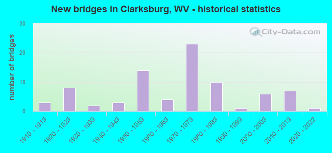
- New bridges - historical statistics
- 31910-1919
- 81920-1929
- 21930-1939
- 31940-1949
- 141950-1959
- 41960-1969
- 231970-1979
- 101980-1989
- 11990-1999
- 62000-2009
- 72010-2019
- 12020-2022
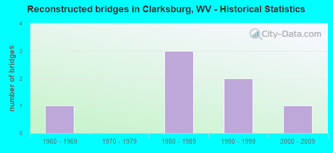
- Reconstructed bridges - Historical Statistics
- 11960-1969
- 01970-1979
- 31980-1989
- 21990-1999
- 12000-2009
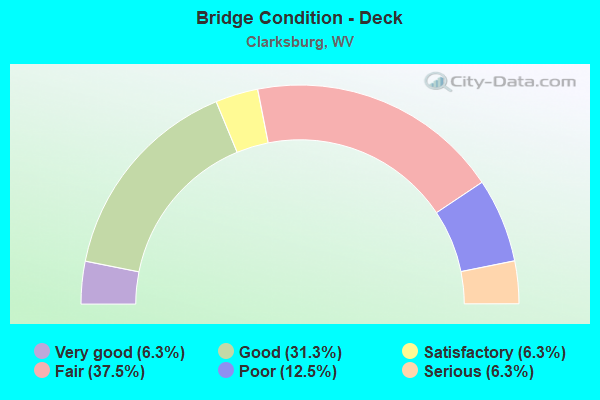
- Bridge Condition - Deck
- 6.3%Very good
- 31.3%Good
- 6.3%Satisfactory
- 37.5%Fair
- 12.5%Poor
- 6.3%Serious
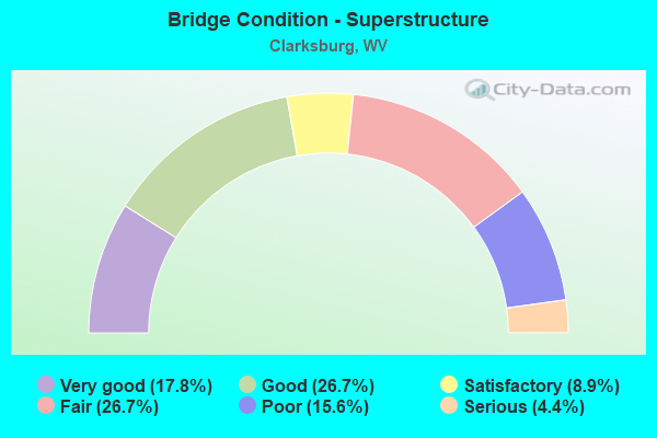
- Bridge Condition - Superstructure
- 17.8%Very good
- 26.7%Good
- 8.9%Satisfactory
- 26.7%Fair
- 15.6%Poor
- 4.4%Serious
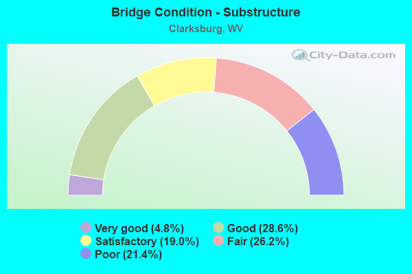
- Bridge Condition - Substructure
- 4.8%Very good
- 28.6%Good
- 19.0%Satisfactory
- 26.2%Fair
- 21.4%Poor
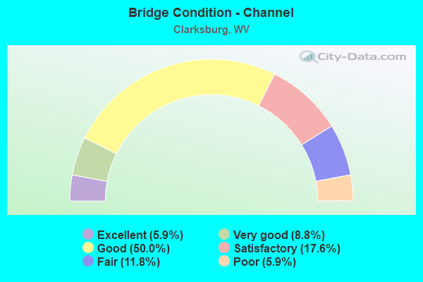
- Bridge Condition - Channel
- 5.9%Excellent
- 8.8%Very good
- 50.0%Good
- 17.6%Satisfactory
- 11.8%Fair
- 5.9%Poor
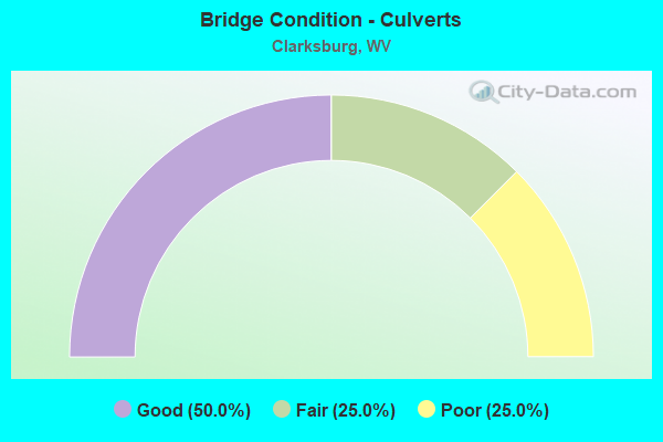
- Bridge Condition - Culverts
- 50.0%Good
- 25.0%Fair
- 25.0%Poor
Find on map >> Show street view
Structure Number: 17A053, Location: 0.04 MI NORTH CO RT 50/40 (Lat: 39.286319, Lng: -80.389189), Route carried "on" structure: County highway 900, Year Built: 1941, Status: Posted for load, Structure Length: 1.24m (4.07ft), Average Daily Traffic: 3,900 (year 2018), Truck Traffic: 7%, Average Future Daily Traffic: 5,100 (year 2038), Features Intersected: LIMESTONE RUN, Facility Carried by Structure: HARRISON CO RT 9
Minimum Vertical Clearance: 30+ m (98+ ft), Kilometerpoint: 0.563, Lanes on structure: 2, Owner: State Highway Agency, Approaching Roadway Width: 7.9m (25.9ft), Skew: 3 degrees, Material/Design: Concrete, Design/Construction: Tee Beam, Number Of Spans In Main Unit: 1, Length of Maximum Span: 10.8m (35.4ft), Curb-To-Curb Width: 6.1m (20.0ft), Out-to-Out Width: 7.0m (23.0ft)
Condition: Deck: Serious, Superstructure: Serious, Substructure: Fair, Channel: Poor, Operating Rating: 23.6 metric tons, Method Used To Determine Operating Rating: Field evaluation and documented engineering judgment, Inventory Rating: 10.9 metric tons, Method Used To Determine Inventory Rating: Field evaluation and documented engineering judgment, Structural Evaluation: High priority of replacement, Deck Geometry: High priority of replacement, Waterway Adequacy: Equal to present minimum criteria, Approach Roadway Alignment: Equal to present desirable criteria, Length Of Structure Improvement: 1.95m (6.40ft), Designated Inspection Frequency: Every 24 months, Inspection Date: June 2020, Bridge Improvement Cost: $263,000, Roadway Improvement Cost: $224,000, Total Project Cost: $587,000 ( Estimate for 2020), Deck Structure Type: Concrete Cast-file-Place, Wearing Surface/Protective System: Wearing Surface: Bituminous
Find on map >> Show street view
Structure Number: 17A063, Location: 0.04 MI NORTH CO RT 34 (Lat: 39.239231, Lng: -80.357289), Route carried "on" structure: County highway 3402, Year Built: 1913, Year Reconstructed: 2006, Status: Open, Structure Length: 6.84m (22.44ft), Average Daily Traffic: 100 (year 2020), Average Future Daily Traffic: 130 (year 2040), Design Load: HS 25 or greater, Features Intersected: WEST FORK RIVER, Facility Carried by Structure: HARRISON CR 34/2
Minimum Vertical Clearance: 5.61m (18.41ft), Kilometerpoint: 0.064, Lanes on structure: 1, Owner: State Highway Agency, Approaching Roadway Width: 4.9m (16.1ft), Material/Design: Steel, Design/Construction: Truss - Thru, Number Of Spans In Main Unit: 2, Length of Maximum Span: 34.4m (112.9ft), Curb-To-Curb Width: 3.5m (11.5ft), Out-to-Out Width: 4.2m (13.8ft)
Condition: Deck: Good, Superstructure: Fair, Substructure: Fair, Channel: Good, Operating Rating: 80.7 metric tons, Method Used To Determine Operating Rating: Load Factor (LF), Inventory Rating: 49.0 metric tons, Method Used To Determine Inventory Rating: Load Factor (LF), Structural Evaluation: Somewhat better than minimum adequacy, Deck Geometry: High priority of corrective action, Waterway Adequacy: Better than present minimum criteria, Approach Roadway Alignment: Better than present minimum criteria, Length Of Structure Improvement: 7.74m (25.39ft), Designated Inspection Frequency: Every 24 months, Critical Feature Inspection Frequency: Every 24 months, Underwater Inspection Frequency: Every 60 months, Inspection Date: November 2020, Critical Feature Inspection Date: November 2020, Underwater Inspection Date: July 2018, Bridge Improvement Cost: $1,644,000, Roadway Improvement Cost: $253,000, Total Project Cost: $1,951,000 ( Estimate for 2020), Deck Structure Type: Concrete Cast-file-Place, Wearing Surface/Protective System: Deck Protection: Galvanized Reinforcing
Find on map >> Show street view
Structure Number: 17A074, Location: 0.07 MI SOUTH WV RT 20 (Lat: 39.281600, Lng: -80.351269), Route carried "on" structure: US 1900, Year Built: 1934, Status: Open, Structure Length: 5.40m (17.72ft), Average Daily Traffic: 8,300 (year 2018), Truck Traffic: 7%, Average Future Daily Traffic: 10,875 (year 2038), Features Intersected: WEST FORK RIVER, Facility Carried by Structure: US ROUTE 19
Minimum Vertical Clearance: 30+ m (98+ ft), Kilometerpoint: 25.025, Lanes on structure: 3, Owner: State Highway Agency, Approaching Roadway Width: 11.0m (36.1ft), Material/Design: Concrete, Design/Construction: Arch - Deck, Number Of Spans In Main Unit: 2, Length of Maximum Span: 26.2m (86.0ft), Curb or Sidewalk Widths: Left: 1.8m (5.9ft), Right: 1.8m (5.9ft), Curb-To-Curb Width: 11.0m (36.1ft), Out-to-Out Width: 15.4m (50.5ft)
Condition: Superstructure: Poor, Substructure: Poor, Channel: Good, Operating Rating: 55.3 metric tons, Method Used To Determine Operating Rating: Field evaluation and documented engineering judgment, Inventory Rating: 21.8 metric tons, Method Used To Determine Inventory Rating: Field evaluation and documented engineering judgment, Structural Evaluation: Meets minimum limits, Deck Geometry: High priority of replacement, Waterway Adequacy: Equal to present minimum criteria, Approach Roadway Alignment: Better than present minimum criteria, Length Of Structure Improvement: 6.68m (21.92ft), Designated Inspection Frequency: Every 24 months, Inspection Date: September 2020, Bridge Improvement Cost: $1,154,000, Roadway Improvement Cost: $681,000, Total Project Cost: $2,069,000 ( Estimate for 2020)
Find on map >> Show street view
Structure Number: 17A075, Location: 0.01 MI NORTH WV RT 20 (Lat: 39.282089, Lng: -80.351711), Route carried "on" structure: US 1900, Year Built: 1928, Status: Open, Structure Length: 3.35m (10.99ft), Average Daily Traffic: 8,300 (year 2018), Truck Traffic: 7%, Average Future Daily Traffic: 10,875 (year 2038), Features Intersected: ELK CREEK, Facility Carried by Structure: US ROUTE 19
Minimum Vertical Clearance: 30+ m (98+ ft), Kilometerpoint: 25.154, Lanes on structure: 3, Owner: State Highway Agency, Approaching Roadway Width: 11.0m (36.1ft), Skew: 1 degrees, Material/Design: Concrete, Design/Construction: Arch - Deck, Number Of Spans In Main Unit: 1, Length of Maximum Span: 33.5m (109.9ft), Curb or Sidewalk Widths: Left: 1.9m (6.2ft), Right: 2.2m (7.2ft), Curb-To-Curb Width: 11.0m (36.1ft), Out-to-Out Width: 15.6m (51.2ft)
Condition: Superstructure: Fair, Substructure: Fair, Channel: Good, Operating Rating: 55.3 metric tons, Method Used To Determine Operating Rating: Field evaluation and documented engineering judgment, Inventory Rating: 21.8 metric tons, Method Used To Determine Inventory Rating: Field evaluation and documented engineering judgment, Structural Evaluation: Somewhat better than minimum adequacy, Deck Geometry: High priority of replacement, Waterway Adequacy: Equal to present minimum criteria, Approach Roadway Alignment: Somewhat better than minimum adequacy, Length Of Structure Improvement: 4.27m (14.01ft), Designated Inspection Frequency: Every 24 months, Inspection Date: December 2020, Bridge Improvement Cost: $641,000, Roadway Improvement Cost: $482,000, Total Project Cost: $1,393,000 ( Estimate for 2021)
Find on map >> Show street view
Structure Number: 17A076, Location: 0.53 MI SOUTH CO RT 50/12 (Lat: 39.288161, Lng: -80.352869), Route carried "on" structure: US 1900, Year Built: 1974, Status: Open, Structure Length: 8.80m (28.87ft), Average Daily Traffic: 6,600 (year 2018), Truck Traffic: 7%, Average Future Daily Traffic: 8,650 (year 2038), Design Load: HS 20, Features Intersected: WEST FORK RIVER, Facility Carried by Structure: US ROUTE 19
Minimum Vertical Clearance: 30+ m (98+ ft), Kilometerpoint: 26.184, Lanes on structure: 2, Owner: State Highway Agency, Approaching Roadway Width: 9.4m (30.8ft), Skew: 2 degrees, Material/Design: Steel continuous, Design/Construction: Stringer/Multi-beam, Number Of Spans In Main Unit: 1, Number Of Approach Spans: 2, Length of Maximum Span: 34.1m (111.9ft), Curb or Sidewalk Widths: Left: 0.0m, Right: 1.2m (3.9ft), Curb-To-Curb Width: 8.9m (29.2ft), Out-to-Out Width: 11.1m (36.4ft)
Condition: Deck: Fair, Superstructure: Satisfactory, Substructure: Satisfactory, Channel: Good, Operating Rating: 79.8 metric tons, Method Used To Determine Operating Rating: Load Factor (LF), Inventory Rating: 48.1 metric tons, Method Used To Determine Inventory Rating: Load Factor (LF), Structural Evaluation: Equal to present minimum criteria, Deck Geometry: Meets minimum limits, Waterway Adequacy: Equal to present minimum criteria, Approach Roadway Alignment: Meets minimum limits, Length Of Structure Improvement: 8.81m (28.90ft), Designated Inspection Frequency: Every 24 months, Inspection Date: September 2020, Bridge Improvement Cost: $324,000, Roadway Improvement Cost: $101,000, Total Project Cost: $488,000 ( Estimate for 2020), Deck Structure Type: Concrete Cast-file-Place, Wearing Surface/Protective System: Deck Protection: Epoxy Coated Reinforcing
Find on map >> Show street view
Structure Number: 17A079, Location: 0.03 MI SOUTH CO RT 9/8 (Lat: 39.103400, Lng: -80.135000), Route carried "on" structure: US 1900, Year Built: 1977, Status: Open, Structure Length: 2.52m (8.27ft), Average Daily Traffic: 8,200 (year 2018), Truck Traffic: 7%, Average Future Daily Traffic: 11,000 (year 2038), Design Load: HS 20, Features Intersected: LIMESTONE RUN, Facility Carried by Structure: US ROUTE 19
Minimum Vertical Clearance: 30+ m (98+ ft), Kilometerpoint: 27.472, Lanes on structure: 4, Owner: State Highway Agency, Approaching Roadway Width: 21.6m (70.9ft), Skew: 22 degrees, Material/Design: Prestressed concrete, Design/Construction: Box Beam or Girders - Multiple, Number Of Spans In Main Unit: 1, Number Of Approach Spans: 2, Length of Maximum Span: 8.8m (28.9ft), Curb or Sidewalk Widths: Left: 1.4m (4.6ft), Right: 0.0m, Curb-To-Curb Width: 16.2m (53.1ft), Out-to-Out Width: 18.5m (60.7ft)
Condition: Superstructure: Fair, Substructure: Fair, Channel: Good, Operating Rating: 68.0 metric tons, Method Used To Determine Operating Rating: Load Factor (LF), Inventory Rating: 40.8 metric tons, Method Used To Determine Inventory Rating: Load Factor (LF), Structural Evaluation: Somewhat better than minimum adequacy, Deck Geometry: Meets minimum limits, Waterway Adequacy: Equal to present minimum criteria, Approach Roadway Alignment: Better than present minimum criteria, Designated Inspection Frequency: Every 24 months, Inspection Date: July 2020, Deck Structure Type: Other, Wearing Surface/Protective System: Wearing Surface: Bituminous, Membrane: Preformed Fabric
Find on map >> Show street view
Structure Number: 17A095, Location: 0.15 MI EAST CR 19/14 (Lat: 39.261261, Lng: -80.401950), Route carried "on" structure: County highway 1911, Year Built: 1989, Status: Open, Structure Length: 0.96m (3.15ft), Average Daily Traffic: 650 (year 2018), Truck Traffic: 7%, Average Future Daily Traffic: 850 (year 2038), Design Load: HS 25 or greater, Features Intersected: DAVISSON RUN, Facility Carried by Structure: COUNTY ROUTE 19/11
Minimum Vertical Clearance: 30+ m (98+ ft), Kilometerpoint: 2.124, Lanes on structure: 2, Owner: State Highway Agency, Approaching Roadway Width: 6.1m (20.0ft), Skew: 2 degrees, Material/Design: Prestressed concrete, Design/Construction: Box Beam or Girders - Multiple, Number Of Spans In Main Unit: 1, Length of Maximum Span: 9.1m (29.9ft), Curb-To-Curb Width: 6.0m (19.7ft), Out-to-Out Width: 6.5m (21.3ft)
Condition: Superstructure: Good, Substructure: Good, Channel: Satisfactory, Operating Rating: 88.9 metric tons, Method Used To Determine Operating Rating: Load Factor (LF), Inventory Rating: 57.1 metric tons, Method Used To Determine Inventory Rating: Load Factor (LF), Structural Evaluation: Better than present minimum criteria, Deck Geometry: High priority of replacement, Waterway Adequacy: Better than present minimum criteria, Approach Roadway Alignment: Better than present minimum criteria, Designated Inspection Frequency: Every 24 months, Inspection Date: December 2020, Deck Structure Type: Other, Wearing Surface/Protective System: Wearing Surface: Bituminous, Deck Protection: Epoxy Coated Reinforcing
Find on map >> Show street view
Structure Number: 17A102, Location: 0.16 MI NORTH WV RT 20 SB (Lat: 39.275650, Lng: -80.321931), Route carried "on" structure: State highway 2000, Year Built: 1977, Status: Open, Structure Length: 8.81m (28.90ft), Average Daily Traffic: 17,000 (year 2018), Truck Traffic: 4%, Average Future Daily Traffic: 22,275 (year 2038), Design Load: HS 20, Features Intersected: ELK CREEK, Facility Carried by Structure: WV ROUTE 20
Minimum Vertical Clearance: 30+ m (98+ ft), Kilometerpoint: 20.921, Lanes on structure: 3, Owner: State Highway Agency, Approaching Roadway Width: 12.2m (40.0ft), Skew: 20 degrees, Material/Design: Steel continuous, Design/Construction: Stringer/Multi-beam, Number Of Spans In Main Unit: 1, Number Of Approach Spans: 2, Length of Maximum Span: 33.5m (109.9ft), Curb or Sidewalk Widths: Left: 1.5m (4.9ft), Right: 0.0m, Curb-To-Curb Width: 15.0m (49.2ft), Out-to-Out Width: 17.5m (57.4ft)
Condition: Deck: Fair, Superstructure: Good, Substructure: Fair, Channel: Excellent, Operating Rating: 63.5 metric tons, Method Used To Determine Operating Rating: Load Factor (LF), Inventory Rating: 38.1 metric tons, Method Used To Determine Inventory Rating: Load Factor (LF), Structural Evaluation: Somewhat better than minimum adequacy, Deck Geometry: Equal to present minimum criteria, Waterway Adequacy: Superior to present desirable criteria, Approach Roadway Alignment: Better than present minimum criteria, Designated Inspection Frequency: Every 24 months, Inspection Date: June 2020, Deck Structure Type: Concrete Cast-file-Place, Wearing Surface/Protective System: Wearing Surface: Latex Concrete
Find on map >> Show street view
Structure Number: 17A103, Location: 0.18 MI SOUTH CO RT 20/75 (Lat: 39.276689, Lng: -80.321889), Route carried "on" structure: State highway 2000, Year Built: 1977, Status: Open, Structure Length: 6.58m (21.59ft), Average Daily Traffic: 17,000 (year 2018), Truck Traffic: 4%, Average Future Daily Traffic: 22,275 (year 2038), Design Load: HS 20, Features Intersected: US ROUTE 50, Facility Carried by Structure: WV ROUTE 20
Minimum Vertical Clearance: 30+ m (98+ ft), Kilometerpoint: 21.050, Lanes on structure: 4, Lanes under structure: 4, Owner: State Highway Agency, Approaching Roadway Width: 19.2m (63.0ft), Skew: 20 degrees, Material/Design: Steel continuous, Design/Construction: Stringer/Multi-beam, Number Of Spans In Main Unit: 2, Length of Maximum Span: 32.4m (106.3ft), Curb or Sidewalk Widths: Left: 1.5m (4.9ft), Right: 0.0m, Curb-To-Curb Width: 19.3m (63.3ft), Out-to-Out Width: 21.7m (71.2ft)
Condition: Deck: Fair, Superstructure: Good, Substructure: Good, Operating Rating: 67.1 metric tons, Method Used To Determine Operating Rating: Load Factor (LF), Inventory Rating: 39.9 metric tons, Method Used To Determine Inventory Rating: Load Factor (LF), Structural Evaluation: Better than present minimum criteria, Deck Geometry: Equal to present minimum criteria, Underclear: Somewhat better than minimum adequacy, Approach Roadway Alignment: Equal to present desirable criteria, Designated Inspection Frequency: Every 24 months, Inspection Date: August 2020, Deck Structure Type: Concrete Cast-file-Place, Wearing Surface/Protective System: Wearing Surface: Latex Concrete
Find on map >> Show street view
Structure Number: 17A104, Location: 0.40 MI NORTH WV RT 20 (Lat: 39.277119, Lng: -80.328200), Route carried "on" structure: State highway 2000, Year Built: 1987, Status: Open, Structure Length: 7.65m (25.10ft), Average Daily Traffic: 6,900 (year 2019), Truck Traffic: 6%, Average Future Daily Traffic: 13,200 (year 2041), Design Load: HS 20, Features Intersected: ELK CREEK, Facility Carried by Structure: WV ROUTE 20 SB
Minimum Vertical Clearance: 30+ m (98+ ft), Kilometerpoint: 1.835, Lanes on structure: 3, Owner: State Highway Agency, Approaching Roadway Width: 11.6m (38.1ft), Material/Design: Steel continuous, Design/Construction: Stringer/Multi-beam, Number Of Spans In Main Unit: 2, Length of Maximum Span: 37.5m (123.0ft), Curb or Sidewalk Widths: Left: 1.5m (4.9ft), Right: 1.5m (4.9ft), Curb-To-Curb Width: 11.6m (38.1ft), Out-to-Out Width: 15.2m (49.9ft)
Condition: Deck: Satisfactory, Superstructure: Good, Substructure: Satisfactory, Channel: Excellent, Operating Rating: 78.0 metric tons, Method Used To Determine Operating Rating: Load Factor (LF), Inventory Rating: 47.2 metric tons, Method Used To Determine Inventory Rating: Load Factor (LF), Structural Evaluation: Equal to present minimum criteria, Deck Geometry: High priority of replacement, Waterway Adequacy: Superior to present desirable criteria, Approach Roadway Alignment: Somewhat better than minimum adequacy, Length Of Structure Improvement: 8.81m (28.90ft), Designated Inspection Frequency: Every 24 months, Inspection Date: April 2021, Bridge Improvement Cost: $1,478,000, Roadway Improvement Cost: $996,000, Total Project Cost: $2,775,000 ( Estimate for 2021), Deck Structure Type: Concrete Cast-file-Place, Wearing Surface/Protective System: Deck Protection: Epoxy Coated Reinforcing
Find on map >> Show street view
Structure Number: 17A112, Location: 0.31 MI NORTH WV RT 20 (Lat: 39.278489, Lng: -80.334900), Route carried "on" structure: State highway 2000, Year Built: 1921, Status: Open, Structure Length: 3.05m (10.01ft), Average Daily Traffic: 6,000 (year 2019), Truck Traffic: 4%, Average Future Daily Traffic: 7,850 (year 2038), Features Intersected: ELK CREEK, Facility Carried by Structure: WV ROUTE 20 SB
Minimum Vertical Clearance: 30+ m (98+ ft), Kilometerpoint: 1.255, Lanes on structure: 3, Owner: State Highway Agency, Approaching Roadway Width: 11.6m (38.1ft), Material/Design: Concrete, Design/Construction: Arch - Deck, Number Of Spans In Main Unit: 1, Length of Maximum Span: 30.5m (100.1ft), Curb or Sidewalk Widths: Left: 2.4m (7.9ft), Right: 1.2m (3.9ft), Curb-To-Curb Width: 11.7m (38.4ft), Out-to-Out Width: 16.1m (52.8ft)
Condition: Superstructure: Poor, Channel: Good, Operating Rating: 49.9 metric tons, Method Used To Determine Operating Rating: Field evaluation and documented engineering judgment, Inventory Rating: 20.0 metric tons, Method Used To Determine Inventory Rating: Field evaluation and documented engineering judgment, Structural Evaluation: Meets minimum limits, Deck Geometry: High priority of corrective action, Waterway Adequacy: Equal to present minimum criteria, Approach Roadway Alignment: Equal to present desirable criteria, Length Of Structure Improvement: 3.87m (12.70ft), Designated Inspection Frequency: Every 24 months, Inspection Date: Febuary 2021, Bridge Improvement Cost: $517,000, Roadway Improvement Cost: $462,000, Total Project Cost: $1,174,000 ( Estimate for 2021)
Find on map >> Show street view
Structure Number: 17A147, Location: 0.12 MI SOUTH CO RT 25/10 (Lat: 39.228689, Lng: -80.352169), Route carried "on" structure: County highway 2500, Year Built: 1921, Status: Posted for load, Structure Length: 0.82m (2.69ft), Average Daily Traffic: 1,200 (year 2018), Truck Traffic: 7%, Average Future Daily Traffic: 1,575 (year 2038), Features Intersected: BROWNS CREEK, Facility Carried by Structure: HARRISON CO RT 25
Minimum Vertical Clearance: 30+ m (98+ ft), Kilometerpoint: 15.289, Lanes on structure: 2, Owner: State Highway Agency, Approaching Roadway Width: 7.0m (23.0ft), Skew: 3 degrees, Material/Design: Concrete, Design/Construction: Arch - Deck, Number Of Spans In Main Unit: 1, Length of Maximum Span: 8.2m (26.9ft), Curb or Sidewalk Widths: Left: 0.2m (0.7ft), Right: 0.2m (0.7ft), Curb-To-Curb Width: 6.8m (22.3ft), Out-to-Out Width: 7.3m (24.0ft)
Condition: Superstructure: Poor, Substructure: Satisfactory, Channel: Satisfactory, Operating Rating: 47.2 metric tons, Method Used To Determine Operating Rating: Field evaluation and documented engineering judgment, Inventory Rating: 21.8 metric tons, Method Used To Determine Inventory Rating: Field evaluation and documented engineering judgment, Structural Evaluation: Meets minimum limits, Deck Geometry: High priority of corrective action, Waterway Adequacy: Somewhat better than minimum adequacy, Approach Roadway Alignment: Somewhat better than minimum adequacy, Length Of Structure Improvement: 1.46m (4.79ft), Designated Inspection Frequency: Every 24 months, Inspection Date: December 2020, Bridge Improvement Cost: $202,000, Roadway Improvement Cost: $173,000, Total Project Cost: $551,000 ( Estimate for 2021)
Find on map >> Show street view
Structure Number: 17A149, Location: 0.08 MI SOUTH CO RT 25/10 (Lat: 39.229211, Lng: -80.352561), Route carried "on" structure: County highway 2500, Year Built: 1921, Status: Posted for load, Structure Length: 0.82m (2.69ft), Average Daily Traffic: 1,200 (year 2018), Truck Traffic: 7%, Average Future Daily Traffic: 1,575 (year 2038), Features Intersected: BROWNS CREEK, Facility Carried by Structure: HARRISON CO RT 25
Minimum Vertical Clearance: 30+ m (98+ ft), Kilometerpoint: 15.353, Lanes on structure: 2, Owner: State Highway Agency, Approaching Roadway Width: 7.0m (23.0ft), Skew: 3 degrees, Material/Design: Concrete, Design/Construction: Arch - Deck, Number Of Spans In Main Unit: 1, Length of Maximum Span: 8.2m (26.9ft), Curb or Sidewalk Widths: Left: 0.2m (0.7ft), Right: 0.2m (0.7ft), Curb-To-Curb Width: 6.2m (20.3ft), Out-to-Out Width: 7.3m (24.0ft)
Condition: Superstructure: Serious, Substructure: Good, Channel: Fair, Operating Rating: 47.2 metric tons, Method Used To Determine Operating Rating: Field evaluation and documented engineering judgment, Inventory Rating: 21.8 metric tons, Method Used To Determine Inventory Rating: Field evaluation and documented engineering judgment, Structural Evaluation: High priority of corrective action, Deck Geometry: High priority of replacement, Waterway Adequacy: Somewhat better than minimum adequacy, Approach Roadway Alignment: Somewhat better than minimum adequacy, Length Of Structure Improvement: 1.49m (4.89ft), Designated Inspection Frequency: Every 24 months, Inspection Date: December 2020, Bridge Improvement Cost: $235,000, Roadway Improvement Cost: $182,000, Total Project Cost: $479,000 ( Estimate for 2021)
Find on map >> Show street view
Structure Number: 17A15, Location: 0.04 MI WEST CO RT 25 (Lat: 39.222719, Lng: -80.349719), Route carried "on" structure: County highway 2503, Year Built: 1988, Status: Open, Structure Length: 0.73m (2.40ft), Average Daily Traffic: 400 (year 2018), Truck Traffic: 7%, Average Future Daily Traffic: 525 (year 2038), Design Load: HS 25 or greater, Features Intersected: BROWNS CREEK, Facility Carried by Structure: HARR CO RT 25/3
Minimum Vertical Clearance: 30+ m (98+ ft), Kilometerpoint: 3.830, Lanes on structure: 2, Owner: State Highway Agency, Approaching Roadway Width: 4.9m (16.1ft), Material/Design: Prestressed concrete, Design/Construction: Box Beam or Girders - Multiple, Number Of Spans In Main Unit: 1, Length of Maximum Span: 6.9m (22.6ft), Curb-To-Curb Width: 5.2m (17.1ft), Out-to-Out Width: 5.5m (18.0ft)
Condition: Deck: Good, Superstructure: Good, Substructure: Poor, Channel: Fair, Operating Rating: 88.9 metric tons, Method Used To Determine Operating Rating: Load Factor (LF), Inventory Rating: 59.0 metric tons, Method Used To Determine Inventory Rating: Load Factor (LF), Structural Evaluation: Meets minimum limits, Deck Geometry: High priority of replacement, Waterway Adequacy: Equal to present minimum criteria, Approach Roadway Alignment: Equal to present desirable criteria, Length Of Structure Improvement: 1.31m (4.30ft), Designated Inspection Frequency: Every 24 months, Inspection Date: June 2020, Bridge Improvement Cost: $198,000, Roadway Improvement Cost: $157,000, Total Project Cost: $364,000 ( Estimate for 2020), Deck Structure Type: Other, Wearing Surface/Protective System: Deck Protection: Epoxy Coated Reinforcing
Find on map >> Show street view
Structure Number: 17A152, Location: 0.06 MI WEST CO RT 25 (Lat: 39.214589, Lng: -80.345511), Route carried "on" structure: County highway 2511, Year Built: 1920, Status: Open, Structure Length: 0.85m (2.79ft), Average Daily Traffic: 100 (year 2019), Average Future Daily Traffic: 130 (year 2039), Features Intersected: BROWNS CREEK, Facility Carried by Structure: HARRISON CO. 25/11
Minimum Vertical Clearance: 30+ m (98+ ft), Kilometerpoint: 0.097, Lanes on structure: 1, Owner: State Highway Agency, Approaching Roadway Width: 4.9m (16.1ft), Skew: 2 degrees, Material/Design: Concrete, Design/Construction: Arch - Deck, Number Of Spans In Main Unit: 1, Length of Maximum Span: 8.5m (27.9ft), Curb or Sidewalk Widths: Left: 0.1m (0.3ft), Right: 0.1m (0.3ft), Curb-To-Curb Width: 4.4m (14.4ft), Out-to-Out Width: 5.0m (16.4ft)
Condition: Superstructure: Poor, Substructure: Satisfactory, Channel: Good, Operating Rating: 47.2 metric tons, Method Used To Determine Operating Rating: Field evaluation and documented engineering judgment, Inventory Rating: 21.8 metric tons, Method Used To Determine Inventory Rating: Field evaluation and documented engineering judgment, Structural Evaluation: Meets minimum limits, Deck Geometry: Equal to present minimum criteria, Waterway Adequacy: Equal to present minimum criteria, Approach Roadway Alignment: Better than present minimum criteria, Length Of Structure Improvement: 1.59m (5.22ft), Designated Inspection Frequency: Every 24 months, Inspection Date: January 2021, Bridge Improvement Cost: $183,000, Roadway Improvement Cost: $151,000, Total Project Cost: $417,000 ( Estimate for 2021)
Find on map >> Show street view
Structure Number: 17A167, Location: 0.04 MI WEST CO RT 34/2 (Lat: 39.238331, Lng: -80.357450), Route carried "on" structure: County highway 3400, Year Built: 1949, Status: Open, Structure Length: 0.82m (2.69ft), Average Daily Traffic: 100 (year 2020), Average Future Daily Traffic: 130 (year 2041), Features Intersected: BROWNS CREEK, Facility Carried by Structure: HARRISON CO RT 34
Minimum Vertical Clearance: 30+ m (98+ ft), Kilometerpoint: 4.297, Lanes on structure: 1, Owner: State Highway Agency, Approaching Roadway Width: 6.1m (20.0ft), Material/Design: Steel, Design/Construction: Stringer/Multi-beam, Number Of Spans In Main Unit: 1, Length of Maximum Span: 7.6m (24.9ft), Curb-To-Curb Width: 4.5m (14.8ft), Out-to-Out Width: 4.9m (16.1ft)
Condition: Deck: Poor, Superstructure: Poor, Substructure: Poor, Channel: Good, Operating Rating: 49.9 metric tons, Method Used To Determine Operating Rating: Load Factor (LF), Inventory Rating: 29.9 metric tons, Method Used To Determine Inventory Rating: Load Factor (LF), Structural Evaluation: Meets minimum limits, Deck Geometry: Equal to present minimum criteria, Waterway Adequacy: Better than present minimum criteria, Approach Roadway Alignment: Better than present minimum criteria, Length Of Structure Improvement: 1.37m (4.49ft), Designated Inspection Frequency: Every 24 months, Other Special Inspection Frequency: Every 6 months, Inspection Date: December 2020, Other Special Inspection Date: April 2021, Bridge Improvement Cost: $187,000, Roadway Improvement Cost: $156,000, Total Project Cost: $438,000 ( Estimate for 2021), Deck Structure Type: Corrugated Steel, Wearing Surface/Protective System: Wearing Surface: Bituminous
Find on map >> Show street view
Structure Number: 17A173, Location: 0.06 MI WEST CO RT 25 (Lat: 39.217411, Lng: -80.346439), Route carried "on" structure: County highway 3600, Year Built: 1919, Status: Open, Structure Length: 1.22m (4.00ft), Average Daily Traffic: 50 (year 2018), Average Future Daily Traffic: 65 (year 2038), Features Intersected: BROWNS CREEK, Facility Carried by Structure: HARRISON CO RT 36
Minimum Vertical Clearance: 30+ m (98+ ft), Kilometerpoint: 6.518, Lanes on structure: 2, Owner: State Highway Agency, Approaching Roadway Width: 4.6m (15.1ft), Material/Design: Concrete, Design/Construction: Arch - Deck, Number Of Spans In Main Unit: 1, Length of Maximum Span: 12.2m (40.0ft), Curb-To-Curb Width: 5.1m (16.7ft), Out-to-Out Width: 5.9m (19.4ft)
Condition: Superstructure: Fair, Channel: Satisfactory, Operating Rating: 47.2 metric tons, Method Used To Determine Operating Rating: Field evaluation and documented engineering judgment, Inventory Rating: 21.8 metric tons, Method Used To Determine Inventory Rating: Field evaluation and documented engineering judgment, Structural Evaluation: Somewhat better than minimum adequacy, Deck Geometry: High priority of corrective action, Waterway Adequacy: Meets minimum limits, Approach Roadway Alignment: Meets minimum limits, Length Of Structure Improvement: 1.98m (6.50ft), Designated Inspection Frequency: Every 24 months, Inspection Date: August 2020, Bridge Improvement Cost: $208,000, Roadway Improvement Cost: $173,000, Total Project Cost: $464,000 ( Estimate for 2020)
Find on map >> Show street view
Structure Number: 17A19, Location: 0.20 MI WEST US ROUTE 19 (Lat: 39.291550, Lng: -80.364919), Route carried "on" structure: US 5000, Year Built: 1977, Status: Open, Structure Length: 6.27m (20.57ft), Average Daily Traffic: 26,100 (year 2019), Truck Traffic: 7%, Average Future Daily Traffic: 32,400 (year 2041), Design Load: HS 20, Features Intersected: CSX RAILBED, Facility Carried by Structure: US ROUTE 50
Minimum Vertical Clearance: 30+ m (98+ ft), Kilometerpoint: 21.517, Lanes on structure: 6, Base Highway Network: Yes, Owner: State Highway Agency, Approaching Roadway Width: 28.0m (91.9ft), Skew: 34 degrees, Material/Design: Steel continuous, Design/Construction: Stringer/Multi-beam, Number Of Spans In Main Unit: 1, Number Of Approach Spans: 2, Length of Maximum Span: 24.4m (80.1ft), Curb-To-Curb Width: 36.5m (119.8ft), Out-to-Out Width: 38.5m (126.3ft)
Condition: Deck: Fair, Superstructure: Fair, Substructure: Poor, Operating Rating: 64.4 metric tons, Method Used To Determine Operating Rating: Load Factor (LF), Inventory Rating: 38.1 metric tons, Method Used To Determine Inventory Rating: Load Factor (LF), Structural Evaluation: Meets minimum limits, Deck Geometry: Superior to present desirable criteria, Approach Roadway Alignment: Equal to present desirable criteria, Length Of Structure Improvement: 6.28m (20.60ft), Designated Inspection Frequency: Every 24 months, Inspection Date: January 2021, Bridge Improvement Cost: $1,064,000, Roadway Improvement Cost: $323,000, Total Project Cost: $1,552,000 ( Estimate for 2021), Deck Structure Type: Concrete Cast-file-Place
Find on map >> Show street view
Structure Number: 17A192, Location: 1.22 MI EAST CO RT 9 (Lat: 39.293269, Lng: -80.362289), Route carried "on" structure: US 5000, Year Built: 1977, Status: Open, Structure Length: 5.13m (16.83ft), Average Daily Traffic: 25,900 (year 2018), Truck Traffic: 7%, Average Future Daily Traffic: 33,925 (year 2038), Design Load: HS 20, Features Intersected: US 19 & WV 20, Facility Carried by Structure: US ROUTE 50
Minimum Vertical Clearance: 30+ m (98+ ft), Kilometerpoint: 21.823, Lanes on structure: 4, Lanes under structure: 4, Base Highway Network: Yes, Owner: State Highway Agency, Approaching Roadway Width: 26.2m (86.0ft), Skew: 30 degrees, Material/Design: Steel continuous, Design/Construction: Stringer/Multi-beam, Number Of Spans In Main Unit: 1, Number Of Approach Spans: 2, Length of Maximum Span: 25.1m (82.3ft), Curb-To-Curb Width: 26.2m (86.0ft), Out-to-Out Width: 28.2m (92.5ft)
Condition: Deck: Poor, Superstructure: Fair, Substructure: Fair, Operating Rating: 71.7 metric tons, Method Used To Determine Operating Rating: Load Factor (LF), Inventory Rating: 43.5 metric tons, Method Used To Determine Inventory Rating: Load Factor (LF), Structural Evaluation: Somewhat better than minimum adequacy, Deck Geometry: Superior to present desirable criteria, Underclear: Meets minimum limits, Approach Roadway Alignment: Equal to present desirable criteria, Length Of Structure Improvement: 5.12m (16.80ft), Designated Inspection Frequency: Every 24 months, Inspection Date: August 2020, Bridge Improvement Cost: $1,874,000, Roadway Improvement Cost: $584,000, Total Project Cost: $3,477,000 ( Estimate for 2020), Deck Structure Type: Concrete Cast-file-Place, Wearing Surface/Protective System: Wearing Surface: Integral Concrete
Find on map >> Show street view
Structure Number: 17A195, Location: 0.68 MI EAST US ROUTE 19 (Lat: 39.289500, Lng: -80.351361), Route carried "on" structure: US 5000, Year Built: 1958, Year Reconstructed: 1992, Status: Open, Structure Length: 11.95m (39.21ft), Average Daily Traffic: 41,600 (year 2018), Truck Traffic: 7%, Average Future Daily Traffic: 54,500 (year 2038), Design Load: HS 20, Features Intersected: WEST FORK RIVER, Facility Carried by Structure: US ROUTE 50
Minimum Vertical Clearance: 30+ m (98+ ft), Kilometerpoint: 22.933, Lanes on structure: 4, Base Highway Network: Yes, Owner: State Highway Agency, Approaching Roadway Width: 21.9m (71.9ft), Skew: 31 degrees, Material/Design: Steel continuous, Design/Construction: Girder and Floorbeam System, Number Of Spans In Main Unit: 1, Number Of Approach Spans: 2, Length of Maximum Span: 45.7m (149.9ft), Curb-To-Curb Width: 17.2m (56.4ft), Out-to-Out Width: 18.9m (62.0ft)
Condition: Deck: Fair, Superstructure: Fair, Substructure: Fair, Channel: Good, Operating Rating: 67.1 metric tons, Method Used To Determine Operating Rating: Load Factor (LF), Inventory Rating: 39.9 metric tons, Method Used To Determine Inventory Rating: Load Factor (LF), Structural Evaluation: Somewhat better than minimum adequacy, Deck Geometry: Somewhat better than minimum adequacy, Waterway Adequacy: Superior to present desirable criteria, Approach Roadway Alignment: Equal to present desirable criteria, Designated Inspection Frequency: Every 24 months, Critical Feature Inspection Frequency: Every 24 months, Inspection Date: November 2020, Critical Feature Inspection Date: November 2020, Deck Structure Type: Concrete Cast-file-Place, Wearing Surface/Protective System: Deck Protection: Epoxy Coated Reinforcing
Find on map >> Show street view
Structure Number: 17A198, Location: 0.16 MI WEST CO RT 50/60 (Lat: 39.285731, Lng: -80.346161), Route carried "on" structure: US 5000, Year Built: 1958, Year Reconstructed: 1990, Status: Open, Structure Length: 8.29m (27.20ft), Average Daily Traffic: 20,950 (year 2019), Truck Traffic: 10%, Average Future Daily Traffic: 26,000 (year 2041), Design Load: HS 20, Features Intersected: Elk Creek, City Streets, Facility Carried by Structure: US 50 EB & WB
Minimum Vertical Clearance: 30+ m (98+ ft), Kilometerpoint: 23.561, Lanes on structure: 4, Lanes under structure: 2, Base Highway Network: Yes, Owner: State Highway Agency, Approaching Roadway Width: 21.9m (71.9ft), Skew: 32 degrees, Material/Design: Steel continuous, Design/Construction: Stringer/Multi-beam, Number Of Spans In Main Unit: 1, Number Of Approach Spans: 2, Length of Maximum Span: 30.5m (100.1ft), Curb-To-Curb Width: 17.7m (58.1ft), Out-to-Out Width: 19.4m (63.6ft)
Condition: Deck: Fair, Superstructure: Good, Substructure: Satisfactory, Channel: Satisfactory, Operating Rating: 59.9 metric tons, Method Used To Determine Operating Rating: Load Factor (LF), Inventory Rating: 36.3 metric tons, Method Used To Determine Inventory Rating: Load Factor (LF), Structural Evaluation: Equal to present minimum criteria, Deck Geometry: Somewhat better than minimum adequacy, Underclear: High priority of corrective action, Waterway Adequacy: Superior to present desirable criteria, Approach Roadway Alignment: Equal to present desirable criteria, Designated Inspection Frequency: Every 24 months, Inspection Date: January 2021, Deck Structure Type: Concrete Cast-file-Place, Wearing Surface/Protective System: Deck Protection: Epoxy Coated Reinforcing
Find on map >> Show street view
Structure Number: 17A199, Location: 0.81 MI WEST WV RT 20 (Lat: 39.281081, Lng: -80.334600), Route carried "on" structure: US 5000, Year Built: 1955, Year Reconstructed: 1992, Status: Open, Structure Length: 24.99m (81.99ft), Average Daily Traffic: 47,600 (year 2019), Truck Traffic: 7%, Average Future Daily Traffic: 62,350 (year 2039), Design Load: HS 20, Features Intersected: Elk Creek, City Streets, Facility Carried by Structure: US ROUTE 50
Minimum Vertical Clearance: 30+ m (98+ ft), Kilometerpoint: 24.639, Lanes on structure: 4, Lanes under structure: 2, Base Highway Network: Yes, Owner: State Highway Agency, Approaching Roadway Width: 21.3m (69.9ft), Skew: 30 degrees, Material/Design: Steel continuous, Design/Construction: Stringer/Multi-beam, Number Of Spans In Main Unit: 1, Number Of Approach Spans: 9, Length of Maximum Span: 30.5m (100.1ft), Curb-To-Curb Width: 17.7m (58.1ft), Out-to-Out Width: 19.4m (63.6ft)
Condition: Deck: Fair, Superstructure: Satisfactory, Substructure: Poor, Channel: Good, Operating Rating: 72.6 metric tons, Method Used To Determine Operating Rating: Load Factor (LF), Inventory Rating: 43.5 metric tons, Method Used To Determine Inventory Rating: Load Factor (LF), Structural Evaluation: Meets minimum limits, Deck Geometry: Somewhat better than minimum adequacy, Underclear: High priority of replacement, Waterway Adequacy: Superior to present desirable criteria, Approach Roadway Alignment: Equal to present desirable criteria, Length Of Structure Improvement: 27.49m (90.19ft), Designated Inspection Frequency: Every 24 months, Other Special Inspection Frequency: Every 24 months, Inspection Date: Febuary 2021, Other Special Inspection Date: Febuary 2021, Bridge Improvement Cost: $3,288,000, Roadway Improvement Cost: $471,000, Total Project Cost: $4,411,000 ( Estimate for 2021), Deck Structure Type: Concrete Cast-file-Place, Wearing Surface/Protective System: Deck Protection: Epoxy Coated Reinforcing
Find on map >> Show street view
Structure Number: 17A204, Location: 0.55 MI WEST WV RT 20 (Lat: 39.279511, Lng: -80.330311), Route carried "on" structure: US 5000, Year Built: 1977, Status: Open, Structure Length: 20.34m (66.73ft), Average Daily Traffic: 4,500 (year 2018), Truck Traffic: 7%, Average Future Daily Traffic: 58,950 (year 2038), Design Load: HS 20, Features Intersected: WV 20 & WV 20 CONN., Facility Carried by Structure: US ROUTE 50
Minimum Vertical Clearance: 30+ m (98+ ft), Kilometerpoint: 25.057, Lanes on structure: 4, Lanes under structure: 1, Base Highway Network: Yes, Owner: State Highway Agency, Approaching Roadway Width: 21.9m (71.9ft), Skew: 32 degrees, Material/Design: Prestressed concrete continuous, Design/Construction: Box Beam or Girders - Single/Spread, Number Of Spans In Main Unit: 2, Number Of Approach Spans: 4, Length of Maximum Span: 38.9m (127.6ft), Curb-To-Curb Width: 23.2m (76.1ft), Out-to-Out Width: 25.2m (82.7ft)
Condition: Superstructure: Fair, Substructure: Good, Operating Rating: 85.3 metric tons, Method Used To Determine Operating Rating: Field evaluation and documented engineering judgment, Inventory Rating: 32.7 metric tons, Method Used To Determine Inventory Rating: Field evaluation and documented engineering judgment, Structural Evaluation: Somewhat better than minimum adequacy, Deck Geometry: Superior to present desirable criteria, Underclear: High priority of corrective action, Approach Roadway Alignment: Equal to present desirable criteria, Designated Inspection Frequency: Every 24 months, Inspection Date: March 2020, Deck Structure Type: Concrete Cast-file-Place, Wearing Surface/Protective System: Wearing Surface: Latex Concrete
Find on map >> Show street view
Structure Number: 17A205, Location: 0.22 MI EAST WV RT 20 (Lat: 39.276900, Lng: -80.317869), Route carried "on" structure: US 5000, Year Built: 1977, Status: Open, Structure Length: 4.77m (15.65ft), Average Daily Traffic: 27,250 (year 2018), Truck Traffic: 7%, Average Future Daily Traffic: 35,700 (year 2038), Design Load: HS 20, Features Intersected: CSX RAILROAD, Facility Carried by Structure: US ROUTE 50 EB
Minimum Vertical Clearance: 30+ m (98+ ft), Kilometerpoint: 26.297, Lanes on structure: 3, Base Highway Network: Yes, Owner: State Highway Agency, Approaching Roadway Width: 16.2m (53.1ft), Skew: 1 degrees, Material/Design: Steel continuous, Design/Construction: Stringer/Multi-beam, Number Of Spans In Main Unit: 1, Number Of Approach Spans: 2, Length of Maximum Span: 18.0m (59.1ft), Curb-To-Curb Width: 18.0m (59.1ft), Out-to-Out Width: 19.2m (63.0ft)
Condition: Deck: Fair, Superstructure: Good, Substructure: Good, Operating Rating: 61.7 metric tons, Method Used To Determine Operating Rating: Load Factor (LF), Inventory Rating: 37.2 metric tons, Method Used To Determine Inventory Rating: Load Factor (LF), Structural Evaluation: Better than present minimum criteria, Deck Geometry: Superior to present desirable criteria, Underclear: Better than present minimum criteria, Approach Roadway Alignment: Equal to present desirable criteria, Designated Inspection Frequency: Every 24 months, Inspection Date: July 2020, Deck Structure Type: Concrete Cast-file-Place, Wearing Surface/Protective System: Wearing Surface: Latex Concrete
Find on map >> Show street view
Structure Number: 17A207, Location: 0.22 MI EAST WV ROUTE 20 (Lat: 39.277139, Lng: -80.317989), Route carried "on" structure: US 5000, Year Built: 1977, Status: Open, Structure Length: 4.77m (15.65ft), Average Daily Traffic: 27,250 (year 2018), Truck Traffic: 7%, Average Future Daily Traffic: 35,700 (year 2038), Design Load: HS 20, Features Intersected: CSX RAILROAD, Facility Carried by Structure: US ROUTE 50 WB
Minimum Vertical Clearance: 30+ m (98+ ft), Kilometerpoint: 26.297, Lanes on structure: 3, Base Highway Network: Yes, Owner: State Highway Agency, Approaching Roadway Width: 15.2m (49.9ft), Skew: 1 degrees, Material/Design: Steel continuous, Design/Construction: Stringer/Multi-beam, Number Of Spans In Main Unit: 1, Number Of Approach Spans: 2, Length of Maximum Span: 18.0m (59.1ft), Curb-To-Curb Width: 17.3m (56.8ft), Out-to-Out Width: 18.5m (60.7ft)
Condition: Deck: Fair, Superstructure: Satisfactory, Substructure: Satisfactory, Operating Rating: 54.4 metric tons, Method Used To Determine Operating Rating: Load Factor (LF), Inventory Rating: 32.7 metric tons, Method Used To Determine Inventory Rating: Load Factor (LF), Structural Evaluation: Equal to present minimum criteria, Deck Geometry: Superior to present desirable criteria, Underclear: Better than present minimum criteria, Approach Roadway Alignment: Equal to present desirable criteria, Designated Inspection Frequency: Every 24 months, Inspection Date: July 2020, Deck Structure Type: Concrete Cast-file-Place, Wearing Surface/Protective System: Wearing Surface: Latex Concrete
Find on map >> Show street view
Structure Number: 17A208, Location: 0.43 MI WEST CO RT 50/16 (Lat: 39.278550, Lng: -80.284169), Route carried "on" structure: US 5000, Year Built: 1974, Status: Open, Structure Length: 11.82m (38.78ft), Average Daily Traffic: 48,700 (year 2018), Truck Traffic: 7%, Average Future Daily Traffic: 63,800 (year 2038), Design Load: HS 20, Features Intersected: Interstate 79, Facility Carried by Structure: US ROUTE 50
Minimum Vertical Clearance: 30+ m (98+ ft), Kilometerpoint: 29.097, Lanes on structure: 5, Lanes under structure: 5, Base Highway Network: Yes, Owner: State Highway Agency, Approaching Roadway Width: 26.2m (86.0ft), Skew: 24 degrees, Material/Design: Steel continuous, Design/Construction: Stringer/Multi-beam, Number Of Spans In Main Unit: 1, Number Of Approach Spans: 3, Length of Maximum Span: 37.3m (122.4ft), Curb-To-Curb Width: 25.7m (84.3ft), Out-to-Out Width: 28.2m (92.5ft)
Condition: Deck: Poor, Superstructure: Fair, Substructure: Fair, Operating Rating: 66.2 metric tons, Method Used To Determine Operating Rating: Load Factor (LF), Inventory Rating: 39.9 metric tons, Method Used To Determine Inventory Rating: Load Factor (LF), Structural Evaluation: Somewhat better than minimum adequacy, Deck Geometry: Superior to present desirable criteria, Underclear: Equal to present desirable criteria, Approach Roadway Alignment: Equal to present desirable criteria, Designated Inspection Frequency: Every 24 months, Inspection Date: November 2020, Deck Structure Type: Concrete Cast-file-Place, Wearing Surface/Protective System: Wearing Surface: Latex Concrete
Find on map >> Show street view
Structure Number: 17A227, Location: 0.01 MI NORTH US RT 50 (Lat: 39.287561, Lng: -80.348761), Route carried "on" structure: County highway 5059, Year Built: 1961, Status: Open, Structure Length: 5.12m (16.80ft), Average Daily Traffic: 4,800 (year 2018), Truck Traffic: 7%, Average Future Daily Traffic: 6,300 (year 2038), Design Load: H 15, Features Intersected: US 50 (X), Facility Carried by Structure: HARRISON CR 50/59
Minimum Vertical Clearance: 30+ m (98+ ft), Kilometerpoint: 0.016, Lanes on structure: 2, Lanes under structure: 5, Owner: State Highway Agency, Approaching Roadway Width: 8.5m (27.9ft), Material/Design: Steel continuous, Design/Construction: Stringer/Multi-beam, Number Of Spans In Main Unit: 1, Number Of Approach Spans: 2, Length of Maximum Span: 25.7m (84.3ft), Curb or Sidewalk Widths: Left: 1.5m (4.9ft), Right: 1.5m (4.9ft), Curb-To-Curb Width: 8.5m (27.9ft), Out-to-Out Width: 12.3m (40.4ft)
Condition: Deck: Serious, Superstructure: Poor, Substructure: Poor, Operating Rating: 47.2 metric tons, Method Used To Determine Operating Rating: Load Factor (LF), Inventory Rating: 28.1 metric tons, Method Used To Determine Inventory Rating: Load Factor (LF), Structural Evaluation: Meets minimum limits, Deck Geometry: Meets minimum limits, Underclear: Meets minimum limits, Approach Roadway Alignment: Somewhat better than minimum adequacy, Length Of Structure Improvement: 5.64m (18.50ft), Designated Inspection Frequency: Every 24 months, Inspection Date: September 2020, Bridge Improvement Cost: $1,794,000, Roadway Improvement Cost: $641,000, Total Project Cost: $2,600,000 ( Estimate for 2020), Deck Structure Type: Concrete Cast-file-Place, Wearing Surface/Protective System: Wearing Surface: Bituminous
Find on map >> Show street view
Structure Number: 17A234, Location: 0.01 MI SOUTH US RT 50 WB (Lat: 39.281550, Lng: -80.337550), Route carried "on" structure: Ramp County highway 5061, Year Built: 1957, Year Reconstructed: 1994, Status: Open, Structure Length: 20.11m (65.98ft), Average Daily Traffic: 4,200 (year 2018), Truck Traffic: 7%, Average Future Daily Traffic: 5,500 (year 2038), Design Load: HS 20, Features Intersected: US Route 50, City Street, Facility Carried by Structure: HARR CO RT 50/61
Minimum Vertical Clearance: 4.93m (16.17ft), Kilometerpoint: 0.016, Lanes on structure: 2, Lanes under structure: 2, Owner: State Highway Agency, Approaching Roadway Width: 8.5m (27.9ft), Skew: 9 degrees, Material/Design: Steel, Design/Construction: Stringer/Multi-beam, Number Of Spans In Main Unit: 1, Number Of Approach Spans: 13, Length of Maximum Span: 29.3m (96.1ft), Curb-To-Curb Width: 8.5m (27.9ft), Out-to-Out Width: 9.4m (30.8ft)
Condition: Deck: Satisfactory, Superstructure: Fair, Substructure: Fair, Operating Rating: 75.3 metric tons, Method Used To Determine Operating Rating: Load Factor (LF), Inventory Rating: 45.4 metric tons, Method Used To Determine Inventory Rating: Load Factor (LF), Structural Evaluation: Somewhat better than minimum adequacy, Deck Geometry: High priority of corrective action, Underclear: Meets minimum limits, Approach Roadway Alignment: Meets minimum limits, Length Of Structure Improvement: 20.73m (68.01ft), Designated Inspection Frequency: Every 24 months, Inspection Date: November 2020, Bridge Improvement Cost: $1,888,000, Roadway Improvement Cost: $923,000, Total Project Cost: $2,871,000 ( Estimate for 2020), Deck Structure Type: Concrete Cast-file-Place, Wearing Surface/Protective System: Deck Protection: Epoxy Coated Reinforcing
Find on map >> Show street view
Structure Number: 17A28, Location: 0.18 MI EAST US 50 (Lat: 39.284400, Lng: -80.397569), Route carried "on" structure: County highway 5040, Year Built: 1972, Status: Open, Structure Length: 0.65m (2.13ft), Average Daily Traffic: 1,375 (year 2017), Truck Traffic: 7%, Average Future Daily Traffic: 1,800 (year 2039), Design Load: HS 20, Features Intersected: SIMPSON FORK, Facility Carried by Structure: HARR CO RT 50/40
Minimum Vertical Clearance: 30+ m (98+ ft), Kilometerpoint: 0.290, Lanes on structure: 2, Owner: State Highway Agency, Approaching Roadway Width: 12.2m (40.0ft), Skew: 4 degrees, Material/Design: Concrete continuous, Design/Construction: Culvert, Number Of Spans In Main Unit: 2, Length of Maximum Span: 3.0m (9.8ft)
Condition: Channel: Poor, Culverts: Good, Operating Rating: 71.7 metric tons, Method Used To Determine Operating Rating: Field evaluation and documented engineering judgment, Inventory Rating: 32.7 metric tons, Method Used To Determine Inventory Rating: Field evaluation and documented engineering judgment, Structural Evaluation: Better than present minimum criteria, Waterway Adequacy: Meets minimum limits, Approach Roadway Alignment: Equal to present desirable criteria, Designated Inspection Frequency: Every 24 months, Inspection Date: March 2021
Find on map >> Show street view
Structure Number: 17A283, Location: 0.05 MI EAST US RT 19 (Lat: 39.270519, Lng: -80.369469), Route carried "on" structure: County highway 1957, Year Built: 1960, Status: Open, Structure Length: 0.63m (2.07ft), Average Daily Traffic: 1,300 (year 2018), Truck Traffic: 7%, Average Future Daily Traffic: 1,700 (year 2038), Features Intersected: DAVISSON RUN, Facility Carried by Structure: HARRISON CO 19/57
Minimum Vertical Clearance: 30+ m (98+ ft), Kilometerpoint: 0.080, Lanes on structure: 2, Owner: State Highway Agency, Approaching Roadway Width: 8.5m (27.9ft), Material/Design: Concrete, Design/Construction: Culvert, Number Of Spans In Main Unit: 1, Length of Maximum Span: 6.3m (20.7ft)
Condition: Channel: Fair, Culverts: Fair, Operating Rating: 71.7 metric tons, Method Used To Determine Operating Rating: Field evaluation and documented engineering judgment, Inventory Rating: 32.7 metric tons, Method Used To Determine Inventory Rating: Field evaluation and documented engineering judgment, Structural Evaluation: Somewhat better than minimum adequacy, Waterway Adequacy: Meets minimum limits, Approach Roadway Alignment: Equal to present desirable criteria, Length Of Structure Improvement: 1.25m (4.10ft), Designated Inspection Frequency: Every 24 months, Inspection Date: January 2020, Bridge Improvement Cost: $174,000, Roadway Improvement Cost: $144,000, Total Project Cost: $382,000 ( Estimate for 2020)
Find on map >> Show street view
Structure Number: 17A293, Location: 0.03 MI SOUTH CO RT 19/10 (Lat: 39.307939, Lng: -80.354150), Route carried "on" structure: US 1900, Year Built: 1925, Status: Open, Structure Length: 0.79m (2.59ft), Average Daily Traffic: 8,500 (year 2018), Truck Traffic: 7%, Average Future Daily Traffic: 11,125 (year 2038), Features Intersected: CROOKED RUN, Facility Carried by Structure: US ROUTE 19
Minimum Vertical Clearance: 30+ m (98+ ft), Kilometerpoint: 29.467, Lanes on structure: 2, Owner: State Highway Agency, Approaching Roadway Width: 9.1m (29.9ft), Skew: 6 degrees, Material/Design: Concrete, Design/Construction: Culvert, Number Of Spans In Main Unit: 1, Length of Maximum Span: 7.9m (25.9ft)
Condition: Channel: Fair, Culverts: Poor, Operating Rating: 50.8 metric tons, Method Used To Determine Operating Rating: Field evaluation and documented engineering judgment, Inventory Rating: 23.6 metric tons, Method Used To Determine Inventory Rating: Field evaluation and documented engineering judgment, Structural Evaluation: Meets minimum limits, Waterway Adequacy: Superior to present desirable criteria, Approach Roadway Alignment: Meets minimum limits, Length Of Structure Improvement: 1.43m (4.69ft), Designated Inspection Frequency: Every 24 months, Other Special Inspection Frequency: Every 12 months, Inspection Date: June 2020, Other Special Inspection Date: June 2021, Bridge Improvement Cost: $327,000, Roadway Improvement Cost: $236,000, Total Project Cost: $679,000 ( Estimate for 2020)
Find on map >> Show street view
Structure Number: 17A311, Location: 0.02 MI NORTH WV 58 (Lat: 39.258500, Lng: -80.284600), Route carried "on" structure: County highway 5087, Year Built: 1997, Status: Open, Structure Length: 1.11m (3.64ft), Average Daily Traffic: 25,300 (year 2019), Truck Traffic: 8%, Average Future Daily Traffic: 34,650 (year 2041), Design Load: HS 20, Features Intersected: SMITHFIELD RUN, Facility Carried by Structure: HRR CO RT 50/87
Minimum Vertical Clearance: 30+ m (98+ ft), Kilometerpoint: 3.283, Lanes on structure: 5, Owner: State Highway Agency, Approaching Roadway Width: 20.1m (65.9ft), Material/Design: Aluminum, Iron, Design/Construction: Culvert, Number Of Spans In Main Unit: 1, Length of Maximum Span: 11.1m (36.4ft)
Condition: Channel: Satisfactory, Culverts: Good, Operating Rating: 71.7 metric tons, Method Used To Determine Operating Rating: Field evaluation and documented engineering judgment, Inventory Rating: 32.7 metric tons, Method Used To Determine Inventory Rating: Field evaluation and documented engineering judgment, Structural Evaluation: Better than present minimum criteria, Waterway Adequacy: Superior to present desirable criteria, Approach Roadway Alignment: Better than present minimum criteria, Designated Inspection Frequency: Every 24 months, Inspection Date: April 2021
Find on map >> Show street view
Structure Number: 17A318, Location: 0.70 MI NORTH OF US 50 (Lat: 39.288600, Lng: -80.280100), Route carried "on" structure: Interstate 7900, Year Built: 2004, Status: Open, Structure Length: 9.31m (30.54ft), Average Daily Traffic: 54,900 (year 2017), Truck Traffic: 20%, Average Future Daily Traffic: 79,600 (year 2037), Design Load: HL 93, Features Intersected: HRR CO 50/16, 50/25 & RR, Facility Carried by Structure: INTERSTATE 79
Minimum Vertical Clearance: 30+ m (98+ ft), Kilometerpoint: 193.057, Lanes on structure: 4, Lanes under structure: 2, Base Highway Network: Yes, Owner: State Highway Agency, Approaching Roadway Width: 40.2m (131.9ft), Skew: 3 degrees, Material/Design: Steel continuous, Design/Construction: Stringer/Multi-beam, Number Of Spans In Main Unit: 1, Number Of Approach Spans: 4, Length of Maximum Span: 22.3m (73.2ft), Curb-To-Curb Width: 40.4m (132.5ft), Out-to-Out Width: 41.8m (137.1ft)
Condition: Deck: Good, Superstructure: Good, Substructure: Good, Operating Rating: 75.3 metric tons, Method Used To Determine Operating Rating: Load and Resistance Factor (LRFR), Inventory Rating: 58.0 metric tons, Method Used To Determine Inventory Rating: Load and Resistance Factor (LRFR), Structural Evaluation: Better than present minimum criteria, Deck Geometry: Superior to present desirable criteria, Underclear: Somewhat better than minimum adequacy, Approach Roadway Alignment: Equal to present desirable criteria, Designated Inspection Frequency: Every 24 months, Inspection Date: July 2020, Deck Structure Type: Concrete Cast-file-Place, Wearing Surface/Protective System: Deck Protection: Epoxy Coated Reinforcing
Find on map >> Show street view
Structure Number: 17A332, Location: 0.01 MI EAST OF US 19 (Lat: 39.273269, Lng: -80.368119), Route carried "on" structure: State highway 9800, Year Built: 2006, Status: Open, Structure Length: 7.46m (24.48ft), Average Daily Traffic: 9,700 (year 2018), Truck Traffic: 4%, Average Future Daily Traffic: 12,700 (year 2038), Design Load: HS 25 or greater, Features Intersected: WEST FORK RIVER & TRAIL, Facility Carried by Structure: WV ROUTE 98
Minimum Vertical Clearance: 30+ m (98+ ft), Kilometerpoint: 5.263, Lanes on structure: 3, Owner: State Highway Agency, Approaching Roadway Width: 15.2m (49.9ft), Skew: 2 degrees, Material/Design: Steel continuous, Design/Construction: Stringer/Multi-beam, Number Of Spans In Main Unit: 1, Number Of Approach Spans: 2, Length of Maximum Span: 33.5m (109.9ft), Curb or Sidewalk Widths: Left: 1.5m (4.9ft), Right: 0.0m, Curb-To-Curb Width: 15.2m (49.9ft), Out-to-Out Width: 17.5m (57.4ft)
Condition: Deck: Good, Superstructure: Very good, Substructure: Good, Channel: Good, Operating Rating: 88.9 metric tons, Method Used To Determine Operating Rating: Load Factor (LF), Inventory Rating: 55.3 metric tons, Method Used To Determine Inventory Rating: Load Factor (LF), Structural Evaluation: Better than present minimum criteria, Deck Geometry: Equal to present minimum criteria, Waterway Adequacy: Equal to present desirable criteria, Approach Roadway Alignment: Better than present minimum criteria, Designated Inspection Frequency: Every 24 months, Underwater Inspection Frequency: Every 60 months, Inspection Date: December 2020, Underwater Inspection Date: June 2017, Deck Structure Type: Concrete Cast-file-Place, Wearing Surface/Protective System: Deck Protection: Epoxy Coated Reinforcing
Find on map >> Show street view
Structure Number: 17A343, Location: 0.03 MI W OF HARR CO 25/5 (Lat: 39.217569, Lng: -80.342131), Route carried "on" structure: County highway 2504, Year Built: 2010, Status: Open, Structure Length: 1.58m (5.18ft), Average Daily Traffic: 1,200 (year 2018), Truck Traffic: 7%, Average Future Daily Traffic: 1,575 (year 2038), Design Load: HL 93, Features Intersected: BRANCH OF BROWNS CREEK, Facility Carried by Structure: COUNTY ROUTE 25/4
Minimum Vertical Clearance: 30+ m (98+ ft), Kilometerpoint: 0.306, Lanes on structure: 2, Owner: State Highway Agency, Approaching Roadway Width: 6.1m (20.0ft), Material/Design: Prestressed concrete, Design/Construction: Box Beam or Girders - Multiple, Number Of Spans In Main Unit: 1, Length of Maximum Span: 14.6m (47.9ft), Curb-To-Curb Width: 8.3m (27.2ft), Out-to-Out Width: 8.4m (27.6ft)
Condition: Superstructure: Very good, Substructure: Good, Channel: Very good, Operating Rating: 60.8 metric tons, Method Used To Determine Operating Rating: Load and Resistance Factor (LRFR), Inventory Rating: 46.3 metric tons, Method Used To Determine Inventory Rating: Load and Resistance Factor (LRFR), Structural Evaluation: Better than present minimum criteria, Deck Geometry: Meets minimum limits, Waterway Adequacy: Superior to present desirable criteria, Approach Roadway Alignment: Equal to present minimum criteria, Designated Inspection Frequency: Every 48 months, Inspection Date: September 2020, Deck Structure Type: Other, Wearing Surface/Protective System: Wearing Surface: Bituminous, Membrane: Preformed Fabric, Deck Protection: Epoxy Coated Reinforcing
Find on map >> Show street view
Structure Number: 17A346, Location: 0.04 mi. S. of U.S. 50 W. (Lat: 39.284400, Lng: -80.344100), Route carried "on" structure: County highway 5060, Year Built: 2012, Status: Open, Structure Length: 4.25m (13.94ft), Average Daily Traffic: 7,300 (year 2018), Truck Traffic: 7%, Average Future Daily Traffic: 9,575 (year 2038), Design Load: HL 93, Features Intersected: US 50 (X), Facility Carried by Structure: Har. Co. 50/60
Minimum Vertical Clearance: 30+ m (98+ ft), Kilometerpoint: 0.064, Lanes on structure: 2, Lanes under structure: 4, Owner: State Highway Agency, Approaching Roadway Width: 7.9m (25.9ft), Skew: 5 degrees, Material/Design: Steel, Design/Construction: Stringer/Multi-beam, Number Of Spans In Main Unit: 1, Length of Maximum Span: 39.3m (128.9ft), Curb or Sidewalk Widths: Left: 1.5m (4.9ft), Right: 1.5m (4.9ft), Curb-To-Curb Width: 7.9m (25.9ft), Out-to-Out Width: 11.6m (38.1ft)
Condition: Deck: Good, Superstructure: Very good, Substructure: Satisfactory, Operating Rating: 71.7 metric tons, Method Used To Determine Operating Rating: Load and Resistance Factor (LRFR), Inventory Rating: 55.3 metric tons, Method Used To Determine Inventory Rating: Load and Resistance Factor (LRFR), Structural Evaluation: Equal to present minimum criteria, Deck Geometry: High priority of replacement, Underclear: Equal to present minimum criteria, Approach Roadway Alignment: Equal to present minimum criteria, Designated Inspection Frequency: Every 24 months, Inspection Date: October 2020, Deck Structure Type: Concrete Cast-file-Place, Wearing Surface/Protective System: Deck Protection: Epoxy Coated Reinforcing
Find on map >> Show street view
Structure Number: 17A348, Location: 0.04 mi W of Harr Co 25 (Lat: 39.267739, Lng: -80.361889), Route carried "on" structure: State highway 98, Year Built: 2013, Status: Open, Structure Length: 1.43m (4.69ft), Average Daily Traffic: 9,700 (year 2018), Truck Traffic: 4%, Average Future Daily Traffic: 12,700 (year 2038), Design Load: HL 93, Features Intersected: Fitness Trail
Minimum Vertical Clearance: 30+ m (98+ ft), Kilometerpoint: 6.534, Lanes on structure: 2, Owner: State Highway Agency, Approaching Roadway Width: 12.8m (42.0ft), Material/Design: Steel, Design/Construction: Stringer/Multi-beam, Number Of Spans In Main Unit: 1, Length of Maximum Span: 13.4m (44.0ft), Curb or Sidewalk Widths: Left: 1.5m (4.9ft), Right: 0.0m, Curb-To-Curb Width: 12.8m (42.0ft), Out-to-Out Width: 15.0m (49.2ft)
Condition: Deck: Very good, Superstructure: Very good, Substructure: Satisfactory, Operating Rating: 80.7 metric tons, Method Used To Determine Operating Rating: Load and Resistance Factor (LRFR), Inventory Rating: 61.7 metric tons, Method Used To Determine Inventory Rating: Load and Resistance Factor (LRFR), Structural Evaluation: Equal to present minimum criteria, Deck Geometry: Somewhat better than minimum adequacy, Approach Roadway Alignment: Equal to present desirable criteria, Designated Inspection Frequency: Every 48 months, Inspection Date: May 2020, Deck Structure Type: Concrete Cast-file-Place, Wearing Surface/Protective System: Deck Protection: Epoxy Coated Reinforcing
Find on map >> Show street view
Structure Number: 17A35, Location: 0.02 mi. S of Co Har Rt 7 (Lat: 39.344300, Lng: -80.401300), Route carried "on" structure: County highway 9, Year Built: 2014, Status: Open, Structure Length: 3.25m (10.66ft), Average Daily Traffic: 2,300 (year 2018), Truck Traffic: 7%, Average Future Daily Traffic: 3,025 (year 2038), Design Load: HL 93, Features Intersected: TENMILE CREEK
Minimum Vertical Clearance: 30+ m (98+ ft), Kilometerpoint: 8.192, Lanes on structure: 2, Base Highway Network: Yes, Owner: State Highway Agency, Approaching Roadway Width: 7.9m (25.9ft), Material/Design: Steel, Design/Construction: Stringer/Multi-beam, Number Of Spans In Main Unit: 1, Length of Maximum Span: 30.5m (100.1ft), Curb-To-Curb Width: 7.9m (25.9ft), Out-to-Out Width: 8.7m (28.5ft)
Condition: Deck: Good, Superstructure: Very good, Substructure: Very good, Channel: Very good, Operating Rating: 88.9 metric tons, Method Used To Determine Operating Rating: Load and Resistance Factor (LRFR), Inventory Rating: 61.7 metric tons, Method Used To Determine Inventory Rating: Load and Resistance Factor (LRFR), Structural Evaluation: Equal to present desirable criteria, Deck Geometry: High priority of corrective action, Waterway Adequacy: Equal to present minimum criteria, Approach Roadway Alignment: Equal to present desirable criteria, Designated Inspection Frequency: Every 48 months, Inspection Date: August 2020, Deck Structure Type: Concrete Cast-file-Place, Wearing Surface/Protective System: Deck Protection: Epoxy Coated Reinforcing
Find on map >> Show street view
Structure Number: 17A361, Location: 0.34 mi N of Har Co 25/98 (Lat: 39.270600, Lng: -80.355519), Route carried "on" structure: County highway 2599, Year Built: 2019, Status: Open, Structure Length: 6.06m (19.88ft), Average Daily Traffic: 1,500 (year 2019), Truck Traffic: 8%, Average Future Daily Traffic: 2,055 (year 2041), Design Load: HL 93, Features Intersected: West Fork River, Facility Carried by Structure: Har Co Rt 25/99
Minimum Vertical Clearance: 30+ m (98+ ft), Kilometerpoint: 0.547, Lanes on structure: 2, Owner: State Highway Agency, Approaching Roadway Width: 6.1m (20.0ft), Material/Design: Steel, Design/Construction: Truss - Thru, Number Of Spans In Main Unit: 2, Length of Maximum Span: 29.3m (96.1ft), Curb or Sidewalk Widths: Left: 0.0m, Right: 1.5m (4.9ft), Curb-To-Curb Width: 5.5m (18.0ft), Out-to-Out Width: 5.5m (18.0ft)
Condition: Deck: Good, Superstructure: Good, Substructure: Good, Channel: Good, Operating Rating: 49.0 metric tons, Method Used To Determine Operating Rating: Load and Resistance Factor (LRFR), Inventory Rating: 38.1 metric tons, Method Used To Determine Inventory Rating: Load and Resistance Factor (LRFR), Structural Evaluation: Better than present minimum criteria, Deck Geometry: High priority of replacement, Waterway Adequacy: Equal to present minimum criteria, Approach Roadway Alignment: Meets minimum limits, Designated Inspection Frequency: Every 24 months, Critical Feature Inspection Frequency: Every 24 months, Inspection Date: Febuary 2021, Critical Feature Inspection Date: July 2021, Deck Structure Type: Concrete Cast-file-Place, Wearing Surface/Protective System: Deck Protection: Epoxy Coated Reinforcing