Bridge Statistics for Clarksville, Indiana (IN)
Condition, Traffic, Stress, Structural Evaluation, Project Costs
- National Bridge Inventory (NBI) Statistics
- 83Number of bridges
- 728ft / 222mTotal length
- $4,727,000Total costs
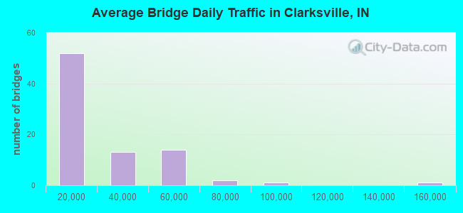
- 1,732,652Total average daily traffic
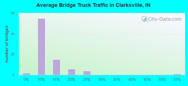
- 159,509Total average daily truck traffic
- National Bridge Inventory (NBI) Registered Bridges for Clarksville
- No street view available for this location
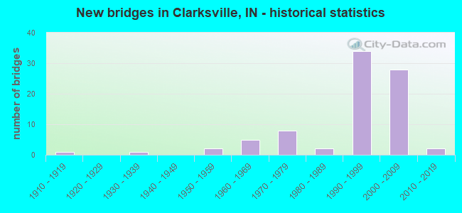
- New bridges - historical statistics
- 11910-1919
- 11930-1939
- 21950-1959
- 51960-1969
- 81970-1979
- 21980-1989
- 341990-1999
- 282000-2009
- 22010-2019
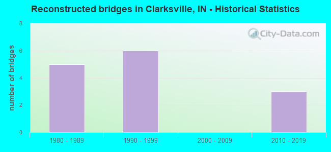
- Reconstructed bridges - Historical Statistics
- 51980-1989
- 61990-1999
- 02000-2009
- 32010-2019
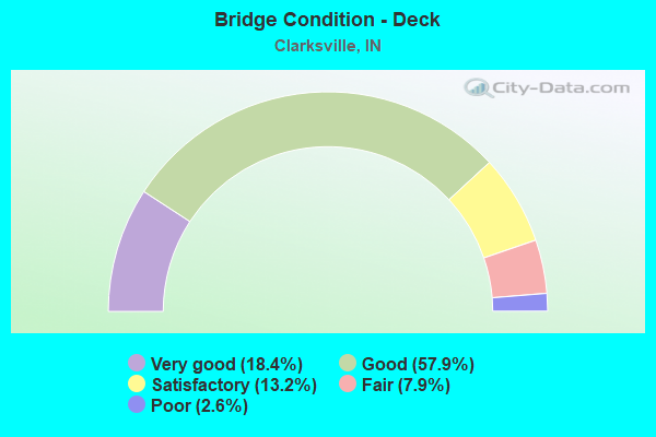
- Bridge Condition - Deck
- 18.4%Very good
- 57.9%Good
- 13.2%Satisfactory
- 7.9%Fair
- 2.6%Poor
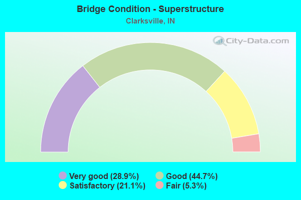
- Bridge Condition - Superstructure
- 28.9%Very good
- 44.7%Good
- 21.1%Satisfactory
- 5.3%Fair
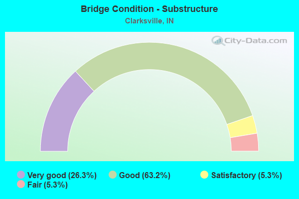
- Bridge Condition - Substructure
- 26.3%Very good
- 63.2%Good
- 5.3%Satisfactory
- 5.3%Fair
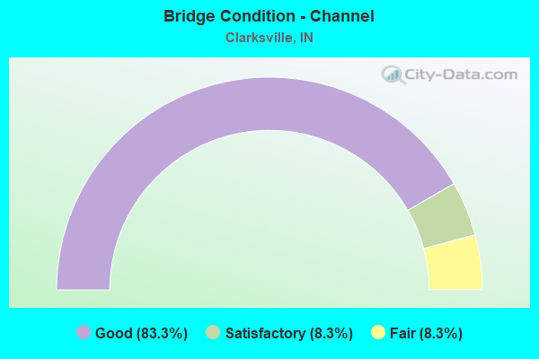
- Bridge Condition - Channel
- 83.3%Good
- 8.3%Satisfactory
- 8.3%Fair
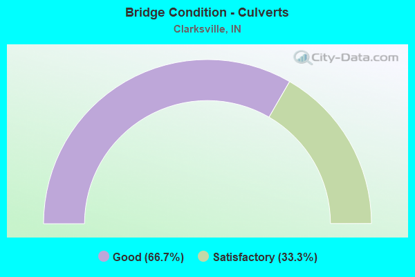
- Bridge Condition - Culverts
- 66.7%Good
- 33.3%Satisfactory
Find on map >> Show street view
Structure Number: 1000135, Location: 00.20 NE of County Line R (Lat: 38.359850, Lng: -85.765081), Route carried "on" structure: County highway , Year Built: 2008, Status: Open, Structure Length: 0.84m (2.76ft), Average Daily Traffic: 610 (year 2018), Truck Traffic: 3%, Average Future Daily Traffic: 1,060 (year 2038), Design Load: HS 20, Features Intersected: PLUM RUN, Facility Carried by Structure: PAYNE-KOEHLER RD
Minimum Vertical Clearance: 30+ m (98+ ft), Kilometerpoint: 0.000, Lanes on structure: 2, Owner: County Highway Agency, Approaching Roadway Width: 7.3m (24.0ft), Skew: 2 degrees, Material/Design: Concrete, Design/Construction: Slab, Number Of Spans In Main Unit: 1, Length of Maximum Span: 7.3m (24.0ft), Curb-To-Curb Width: 7.4m (24.3ft), Out-to-Out Width: 7.5m (24.6ft)
Condition: Deck: Very good, Superstructure: Very good, Substructure: Good, Channel: Good, Operating Rating: 82.0 metric tons, Method Used To Determine Operating Rating: Load and Resistance Factor (LRFR), Inventory Rating: 60.9 metric tons, Method Used To Determine Inventory Rating: Load and Resistance Factor (LRFR), Structural Evaluation: Better than present minimum criteria, Deck Geometry: Meets minimum limits, Waterway Adequacy: Equal to present minimum criteria, Approach Roadway Alignment: Equal to present desirable criteria, Designated Inspection Frequency: Every 24 months, Inspection Date: March 2020, Deck Structure Type: Concrete Cast-file-Place, Wearing Surface/Protective System: Wearing Surface: Monolithic Concrete
Find on map >> Show street view
Structure Number: 1000144, Location: 00.57 W US 31 (Lat: 38.359119, Lng: -85.747153), Route carried "on" structure: State highway 60, Year Built: 1969, Year Reconstructed: 1993, Status: Open, Structure Length: 7.58m (24.87ft), Average Daily Traffic: 9,300 (year 2018), Truck Traffic: 5%, Average Future Daily Traffic: 16,180 (year 2038), Design Load: HS 20, Features Intersected: SILVER CREEK, Facility Carried by Structure: APPLELEAF LN
Minimum Vertical Clearance: 30+ m (98+ ft), Kilometerpoint: 1.400, Lanes on structure: 2, Owner: County Highway Agency, Approaching Roadway Width: 10.7m (35.1ft), Material/Design: Prestressed concrete continuous, Design/Construction: Stringer/Multi-beam, Number Of Spans In Main Unit: 5, Length of Maximum Span: 15.7m (51.5ft), Curb-To-Curb Width: 10.2m (33.5ft), Out-to-Out Width: 11.3m (37.1ft)
Condition: Deck: Satisfactory, Superstructure: Satisfactory, Substructure: Good, Channel: Satisfactory, Operating Rating: 36.6 metric tons, Method Used To Determine Operating Rating: Load Factor (LF), Inventory Rating: 21.9 metric tons, Method Used To Determine Inventory Rating: Load Factor (LF), Structural Evaluation: Somewhat better than minimum adequacy, Deck Geometry: Meets minimum limits, Waterway Adequacy: Equal to present minimum criteria, Approach Roadway Alignment: Equal to present minimum criteria, Designated Inspection Frequency: Every 24 months, Inspection Date: March 2020, Deck Structure Type: Concrete Cast-file-Place, Wearing Surface/Protective System: Wearing Surface: Latex Concrete
Find on map >> Show street view
Structure Number: 8921, Location: 00.35 N I-65 (Lat: 38.279461, Lng: -85.750289), Route carried "under" structure: Alternate State highway 62, Year Built: 2016, Structure Length: 0. m, Average Daily Traffic: 19,000 (year 2015), Truck Traffic: 9%, Features Intersected: SR 62X (10TH STREET), Facility Carried by Structure: US 31 SB
Minimum Vertical Clearance: 5.09m (16.70ft), Kilometerpoint: 1.223, Lanes on structure: 3, Lanes under structure: 2, Material/Design: Prestressed concrete, Design/Construction: Tee Beam, Length of Maximum Span: 26.1m (85.6ft)
Find on map >> Show street view
Structure Number: 8953, Location: 00.89 S of SR-265 (Lat: 38.329611, Lng: -85.750014), Route carried "under" structure: US 31, Year Built: 2004, Structure Length: 0. m, Average Daily Traffic: 8,611 (year 2004), Truck Traffic: 5%, Features Intersected: US-31, Facility Carried by Structure: VETERANS PARKWAY
Minimum Vertical Clearance: 8.10m (26.57ft), Kilometerpoint: 7.644, Lanes on structure: 5, Lanes under structure: 3, Material/Design: Prestressed concrete continuous, Design/Construction: Stringer/Multi-beam, Length of Maximum Span: 20.5m (67.3ft)
Find on map >> Show street view
Structure Number: 2631, Location: 01.85 S I-65 (Lat: 38.302881, Lng: -85.781714), Route carried "under" structure: City street , Year Built: 1960, Structure Length: 0. m, Average Daily Traffic: 20,807 (year 2004), Truck Traffic: 5%, Features Intersected: MCCULLOUGH PIKE, Facility Carried by Structure: BROWNS STA WY EB
Minimum Vertical Clearance: 5.21m (17.09ft), Kilometerpoint: 0.000, Lanes on structure: 3, Lanes under structure: 3, Material/Design: Steel continuous, Design/Construction: Stringer/Multi-beam, Length of Maximum Span: 16.8m (55.1ft)
Find on map >> Show street view
Structure Number: 2631, Location: 01.85 S I-65 (Lat: 38.302881, Lng: -85.781711), Route carried "under" structure: County highway , Year Built: 1960, Structure Length: 0. m, Average Daily Traffic: 20,807 (year 2004), Truck Traffic: 5%, Features Intersected: MCCULLOUGH PIKE, Facility Carried by Structure: BROWNS STA WY WB
Minimum Vertical Clearance: 4.65m (15.26ft), Kilometerpoint: 0.000, Lanes on structure: 3, Lanes under structure: 2, Material/Design: Steel continuous, Design/Construction: Stringer/Multi-beam, Length of Maximum Span: 16.8m (55.1ft)
Find on map >> Show street view
Structure Number: 346, Location: 00.19 N SR-62X (Lat: 38.282650, Lng: -85.752725), Route carried "under" structure: Interstate 65, Year Built: 2004, Structure Length: 0. m, Average Daily Traffic: 44,150 (year 2004), Truck Traffic: 20%, Features Intersected: I-65 NBL, Facility Carried by Structure: LOUISVILLE & IN RR
Minimum Vertical Clearance: 5.11m (16.77ft), Kilometerpoint: 1.867, Lanes under structure: 14, Material/Design: Steel, Design/Construction: Girder and Floorbeam System, Length of Maximum Span: 37.1m (121.7ft)
Find on map >> Show street view
Structure Number: 346, Location: 00.19 N SR-62X (Lat: 38.282650, Lng: -85.752725), Route carried "under" structure: Interstate 65, Year Built: 2004, Structure Length: 0. m, Average Daily Traffic: 44,150 (year 2004), Truck Traffic: 20%, Features Intersected: I-65 SBL, Facility Carried by Structure: LOUISVILLE & IN RR
Minimum Vertical Clearance: 5.28m (17.32ft), Kilometerpoint: 1.867, Lanes under structure: 14, Material/Design: Steel, Design/Construction: Girder and Floorbeam System, Length of Maximum Span: 37.1m (121.7ft)
Find on map >> Show street view
Structure Number: 346, Location: 00.19 N SR-62X (Lat: 38.282650, Lng: -85.752725), Route carried "under" structure: US 31, Year Built: 2004, Structure Length: 0. m, Average Daily Traffic: 16,398 (year 2004), Truck Traffic: 10%, Features Intersected: US-31 NBL, Facility Carried by Structure: LOUISVILLE & IN RR
Minimum Vertical Clearance: 5.11m (16.77ft), Kilometerpoint: 1.867, Lanes under structure: 14, Material/Design: Steel, Design/Construction: Girder and Floorbeam System, Length of Maximum Span: 37.1m (121.7ft)
Find on map >> Show street view
Structure Number: 346, Location: 00.19 N SR-62X (Lat: 38.282650, Lng: -85.752725), Route carried "under" structure: US 31, Year Built: 2004, Structure Length: 0. m, Average Daily Traffic: 16,398 (year 2004), Truck Traffic: 10%, Features Intersected: US-31 SBL, Facility Carried by Structure: LOUISVILLE & IN RR
Minimum Vertical Clearance: 5.36m (17.59ft), Kilometerpoint: 1.867, Lanes under structure: 14, Material/Design: Steel, Design/Construction: Girder and Floorbeam System, Length of Maximum Span: 37.1m (121.7ft)
Find on map >> Show street view
Structure Number: 3461, Location: 00.45 N SR 62X (Lat: 38.284611, Lng: -85.754569), Route carried "under" structure: City street , Year Built: 2004, Structure Length: 0. m, Average Daily Traffic: 7,741 (year 2004), Truck Traffic: 5%, Features Intersected: STANSIFER AVENUE, Facility Carried by Structure: I-65 NB
Minimum Vertical Clearance: 4.70m (15.42ft), Kilometerpoint: 0.000, Lanes on structure: 4, Lanes under structure: 6, Material/Design: Steel, Design/Construction: Stringer/Multi-beam, Length of Maximum Span: 36.0m (118.1ft)
Find on map >> Show street view
Structure Number: 34611, Location: 00.45 N SR 62X (Lat: 38.284569, Lng: -85.754867), Route carried "under" structure: City street , Year Built: 2004, Structure Length: 0. m, Average Daily Traffic: 5,000 (year 2013), Truck Traffic: 5%, Features Intersected: STANSIFER AVENUE, Facility Carried by Structure: I-65 SB
Minimum Vertical Clearance: 4.40m (14.44ft), Kilometerpoint: 0.000, Lanes on structure: 6, Lanes under structure: 6, Material/Design: Steel, Design/Construction: Stringer/Multi-beam, Length of Maximum Span: 36.0m (118.1ft)
Find on map >> Show street view
Structure Number: 34616, Location: 00.86 N SR 62X (Lat: 38.289850, Lng: -85.757300), Route carried "under" structure: Interstate 65, Year Built: 2004, Structure Length: 0. m, Average Daily Traffic: 44,150 (year 2004), Truck Traffic: 10%, Features Intersected: I-65 NBL, Facility Carried by Structure: WB BROWN STA RD
Minimum Vertical Clearance: 7.98m (26.18ft), Kilometerpoint: 2.784, Lanes on structure: 2, Lanes under structure: 13, Material/Design: Steel continuous, Design/Construction: Stringer/Multi-beam, Length of Maximum Span: 60.7m (199.1ft)
Find on map >> Show street view
Structure Number: 34616, Location: 00.86 N SR 62X (Lat: 38.289850, Lng: -85.757300), Route carried "under" structure: Ramp US 31, Year Built: 2004, Structure Length: 0. m, Average Daily Traffic: 5,500 (year 2004), Truck Traffic: 10%, Features Intersected: I-65 NB TO US-31 NB RAMP, Facility Carried by Structure: WB BROWN STA RD
Minimum Vertical Clearance: 6.35m (20.83ft), Kilometerpoint: 2.784, Lanes on structure: 2, Lanes under structure: 13, Material/Design: Steel continuous, Design/Construction: Stringer/Multi-beam, Length of Maximum Span: 60.7m (199.1ft)
Find on map >> Show street view
Structure Number: 34616, Location: 00.86 N SR 62X (Lat: 38.289850, Lng: -85.757300), Route carried "under" structure: US 31, Year Built: 2004, Structure Length: 0. m, Average Daily Traffic: 16,398 (year 2004), Truck Traffic: 10%, Features Intersected: US-31 SBL, Facility Carried by Structure: WB BROWN STA RD
Minimum Vertical Clearance: 5.94m (19.49ft), Kilometerpoint: 2.784, Lanes on structure: 2, Lanes under structure: 13, Material/Design: Steel continuous, Design/Construction: Stringer/Multi-beam, Length of Maximum Span: 60.7m (199.1ft)
Find on map >> Show street view
Structure Number: 34616, Location: 00.86 N SR 62X (Lat: 38.289850, Lng: -85.757300), Route carried "under" structure: Interstate 65, Year Built: 2004, Structure Length: 0. m, Average Daily Traffic: 44,150 (year 2004), Truck Traffic: 10%, Features Intersected: I-65 SBL, Facility Carried by Structure: WB BROWN STA RD
Minimum Vertical Clearance: 7.34m (24.08ft), Kilometerpoint: 2.784, Lanes on structure: 2, Lanes under structure: 13, Material/Design: Steel continuous, Design/Construction: Stringer/Multi-beam, Length of Maximum Span: 60.7m (199.1ft)
Find on map >> Show street view
Structure Number: 34616, Location: 00.86 N SR 62X (Lat: 38.289850, Lng: -85.757300), Route carried "under" structure: US 31, Year Built: 2004, Structure Length: 0. m, Average Daily Traffic: 16,398 (year 2004), Truck Traffic: 10%, Features Intersected: US-31 NBL, Facility Carried by Structure: WB BROWN STA RD
Minimum Vertical Clearance: 6.35m (20.83ft), Kilometerpoint: 2.784, Lanes on structure: 2, Lanes under structure: 13, Material/Design: Steel continuous, Design/Construction: Stringer/Multi-beam, Length of Maximum Span: 60.7m (199.1ft)
Find on map >> Show street view
Structure Number: 3464, Location: 01.20 N SR 62X (Lat: 38.294761, Lng: -85.756989), Route carried "under" structure: Interstate 65, Year Built: 2004, Structure Length: 0. m, Average Daily Traffic: 44,150 (year 2004), Truck Traffic: 5%, Features Intersected: I-65 SB, Facility Carried by Structure: EASTERN BOULEVARD
Minimum Vertical Clearance: 5.87m (19.26ft), Kilometerpoint: 3.331, Lanes on structure: 6, Lanes under structure: 9, Material/Design: Prestressed concrete continuous, Design/Construction: Tee Beam, Length of Maximum Span: 27.6m (90.6ft)
Find on map >> Show street view
Structure Number: 3464, Location: 01.20 N SR 62X (Lat: 38.294761, Lng: -85.756989), Route carried "under" structure: Interstate 65, Year Built: 2004, Structure Length: 0. m, Average Daily Traffic: 44,150 (year 2004), Truck Traffic: 5%, Features Intersected: I-65 NB, Facility Carried by Structure: EASTERN BOULEVARD
Minimum Vertical Clearance: 6.63m (21.75ft), Kilometerpoint: 3.331, Lanes on structure: 6, Lanes under structure: 9, Material/Design: Prestressed concrete continuous, Design/Construction: Tee Beam, Length of Maximum Span: 27.6m (90.6ft)
Find on map >> Show street view
Structure Number: 3469, Location: 01.78 S I-265 EBL (Lat: 38.319089, Lng: -85.752961), Route carried "under" structure: US 31, Year Built: 2003, Structure Length: 0. m, Average Daily Traffic: 8,611 (year 2004), Truck Traffic: 19%, Features Intersected: US 31 SBL/L&C PARKWAY, Facility Carried by Structure: I-65 NB
Minimum Vertical Clearance: 5.77m (18.93ft), Kilometerpoint: 5.971, Lanes on structure: 5, Lanes under structure: 6, Material/Design: Prestressed concrete, Design/Construction: Tee Beam, Length of Maximum Span: 37.3m (122.4ft)
Find on map >> Show street view
Structure Number: 347, Location: 01.78 S I-265 EBL (Lat: 38.318931, Lng: -85.753228), Route carried "under" structure: US 31, Year Built: 2003, Structure Length: 0. m, Average Daily Traffic: 8,611 (year 2004), Truck Traffic: 19%, Features Intersected: US 31 SBL, L&C PARKWAY, Facility Carried by Structure: I-65 SB
Minimum Vertical Clearance: 5.94m (19.49ft), Kilometerpoint: 5.987, Lanes on structure: 5, Lanes under structure: 6, Material/Design: Prestressed concrete, Design/Construction: Tee Beam, Length of Maximum Span: 37.3m (122.4ft)
Find on map >> Show street view
Structure Number: 34704, Location: 00.37 N US 31 SB (Lat: 38.321939, Lng: -85.753128), Route carried "under" structure: Ramp Other road , Year Built: 2003, Structure Length: 0. m, Average Daily Traffic: 7,140 (year 2004), Truck Traffic: 5%, Features Intersected: NB FRONTAGE ROADS, Facility Carried by Structure: I-65 NB EXIT LANE
Minimum Vertical Clearance: 5.33m (17.49ft), Kilometerpoint: 6.743, Lanes on structure: 1, Lanes under structure: 2, Material/Design: Steel, Design/Construction: Stringer/Multi-beam, Length of Maximum Span: 49.2m (161.4ft)
Find on map >> Show street view
Structure Number: 49638, Location: 02.50 E SR-311 (Lat: 38.345619, Lng: -85.754106), Route carried "under" structure: Interstate 65, Year Built: 1991, Structure Length: 0. m, Average Daily Traffic: 23,184 (year 2004), Truck Traffic: 5%, Features Intersected: I-65 SBL
Minimum Vertical Clearance: 5.31m (17.42ft), Kilometerpoint: 9.012, Lanes on structure: 3, Lanes under structure: 6, Material/Design: Steel continuous, Design/Construction: Stringer/Multi-beam, Length of Maximum Span: 32.9m (107.9ft)
Find on map >> Show street view
Structure Number: 49638, Location: 02.50 E SR-311 (Lat: 38.345619, Lng: -85.754106), Route carried "under" structure: Interstate 65, Year Built: 1991, Structure Length: 0. m, Average Daily Traffic: 23,184 (year 2004), Truck Traffic: 5%, Features Intersected: I-65 NBL
Minimum Vertical Clearance: 5.39m (17.68ft), Kilometerpoint: 9.012, Lanes on structure: 3, Lanes under structure: 6, Material/Design: Steel continuous, Design/Construction: Stringer/Multi-beam, Length of Maximum Span: 32.9m (107.9ft)
Find on map >> Show street view
Structure Number: 4964, Location: 02.50 E SR-311 (Lat: 38.345900, Lng: -85.754158), Route carried "under" structure: Interstate 65, Year Built: 1972, Structure Length: 0. m, Average Daily Traffic: 23,184 (year 2004), Truck Traffic: 5%, Features Intersected: I-65 SBL
Minimum Vertical Clearance: 5.28m (17.32ft), Kilometerpoint: 9.028, Lanes on structure: 3, Lanes under structure: 6, Material/Design: Steel continuous, Design/Construction: Stringer/Multi-beam, Length of Maximum Span: 32.9m (107.9ft)
Find on map >> Show street view
Structure Number: 4964, Location: 02.50 E SR-311 (Lat: 38.345900, Lng: -85.754158), Route carried "under" structure: Interstate 65, Year Built: 1972, Structure Length: 0. m, Average Daily Traffic: 23,184 (year 2004), Truck Traffic: 5%, Features Intersected: I-65 NBL
Minimum Vertical Clearance: 5.36m (17.59ft), Kilometerpoint: 9.028, Lanes on structure: 3, Lanes under structure: 6, Material/Design: Steel continuous, Design/Construction: Stringer/Multi-beam, Length of Maximum Span: 32.9m (107.9ft)
Find on map >> Show street view
Structure Number: 4965, Location: 02.50 E SR 311 (Lat: 38.343750, Lng: -85.754050), Route carried "under" structure: Interstate 65, Year Built: 1972, Structure Length: 0. m, Average Daily Traffic: 42,578 (year 2004), Truck Traffic: 10%, Features Intersected: I 65 NB
Minimum Vertical Clearance: 5.26m (17.26ft), Kilometerpoint: 8.803, Lanes on structure: 1, Lanes under structure: 2, Material/Design: Steel continuous, Design/Construction: Stringer/Multi-beam, Length of Maximum Span: 32.9m (107.9ft)
Find on map >> Show street view
Structure Number: 4965, Location: 02.50 E SR 311 (Lat: 38.343750, Lng: -85.754050), Route carried "under" structure: Interstate 65, Year Built: 1972, Structure Length: 0. m, Average Daily Traffic: 42,578 (year 2004), Truck Traffic: 10%, Features Intersected: I 65 SB
Minimum Vertical Clearance: 5.16m (16.93ft), Kilometerpoint: 8.803, Lanes on structure: 1, Lanes under structure: 2, Material/Design: Steel continuous, Design/Construction: Stringer/Multi-beam, Length of Maximum Span: 32.9m (107.9ft)
Find on map >> Show street view
Structure Number: 49652, Location: 00.13 E I-65 (Lat: 38.345689, Lng: -85.751611), Route carried "under" structure: Ramp Interstate 65, Year Built: 1991, Structure Length: 0. m, Average Daily Traffic: 146 (year 2004), Truck Traffic: 5%, Features Intersected: I-265 RAMP SW-D TO I-65
Minimum Vertical Clearance: 5.18m (16.99ft), Kilometerpoint: 11.282, Lanes on structure: 3, Lanes under structure: 1, Material/Design: Prestressed concrete continuous, Design/Construction: Stringer/Multi-beam, Length of Maximum Span: 21.3m (69.9ft)
Find on map >> Show street view
Structure Number: 49654, Location: 00.13 E I-65 (Lat: 38.345939, Lng: -85.751633), Route carried "under" structure: Ramp Interstate 65, Year Built: 1991, Structure Length: 0. m, Average Daily Traffic: 146 (year 2004), Truck Traffic: 5%, Features Intersected: I-265 RAMP SW-D TO I-65
Minimum Vertical Clearance: 5.33m (17.49ft), Kilometerpoint: 11.282, Lanes on structure: 2, Lanes under structure: 1, Material/Design: Prestressed concrete continuous, Design/Construction: Stringer/Multi-beam, Length of Maximum Span: 21.3m (69.9ft)
Find on map >> Show street view
Structure Number: 49655, Location: 00.28 E I-65 (Lat: 38.348739, Lng: -85.732431), Route carried "under" structure: City street , Year Built: 1991, Structure Length: 0. m, Average Daily Traffic: 118 (year 2004), Truck Traffic: 5%, Features Intersected: COPPERS LANE, Facility Carried by Structure: SR 265 EB
Minimum Vertical Clearance: 4.67m (15.32ft), Kilometerpoint: 0.000, Lanes on structure: 2, Lanes under structure: 2, Material/Design: Steel continuous, Design/Construction: Stringer/Multi-beam, Length of Maximum Span: 33.1m (108.6ft)
Find on map >> Show street view
Structure Number: 49656, Location: 00.28 E I-65 (Lat: 38.349011, Lng: -85.731911), Route carried "under" structure: City street , Year Built: 1991, Structure Length: 0. m, Average Daily Traffic: 118 (year 2004), Truck Traffic: 5%, Features Intersected: COOPERS LANE, Facility Carried by Structure: SR 265 WB
Minimum Vertical Clearance: 5.89m (19.32ft), Kilometerpoint: 0.000, Lanes on structure: 2, Lanes under structure: 2, Material/Design: Steel continuous, Design/Construction: Stringer/Multi-beam, Length of Maximum Span: 28.9m (94.8ft)
Find on map >> Show street view
Structure Number: 49657, Location: 01.51 E US-31 (Lat: 38.345200, Lng: -85.718789), Route carried "under" structure: County highway , Year Built: 1992, Structure Length: 0. m, Average Daily Traffic: 118 (year 2004), Truck Traffic: 5%, Features Intersected: CHARLESTOWN PIKE, Facility Carried by Structure: SR 265 EB
Minimum Vertical Clearance: 7.29m (23.92ft), Kilometerpoint: 0.000, Lanes on structure: 2, Lanes under structure: 3, Material/Design: Steel continuous, Design/Construction: Stringer/Multi-beam, Length of Maximum Span: 32.5m (106.6ft)
Find on map >> Show street view
Structure Number: 49657, Location: 01.51 E US-31 (Lat: 38.345200, Lng: -85.718789), Route carried "under" structure: ServiceOther road , Year Built: 1992, Structure Length: 0. m, Average Daily Traffic: 5 (year 2012), Truck Traffic: 20%, Features Intersected: PRIVATE DRIVEWAY, Facility Carried by Structure: SR 265 EB
Minimum Vertical Clearance: 7.29m (23.92ft), Kilometerpoint: 0.000, Lanes on structure: 2, Lanes under structure: 3, Material/Design: Steel continuous, Design/Construction: Stringer/Multi-beam, Length of Maximum Span: 32.5m (106.6ft)
Find on map >> Show street view
Structure Number: 49658, Location: 01.51 E US-31 (Lat: 38.345400, Lng: -85.718558), Route carried "under" structure: County highway , Year Built: 1992, Structure Length: 0. m, Average Daily Traffic: 118 (year 2004), Truck Traffic: 5%, Features Intersected: CHARLESTOWN PIKE, Facility Carried by Structure: SR 265 WB
Minimum Vertical Clearance: 7.09m (23.26ft), Kilometerpoint: 0.000, Lanes on structure: 2, Lanes under structure: 3, Material/Design: Steel continuous, Design/Construction: Stringer/Multi-beam, Length of Maximum Span: 32.5m (106.6ft)
Find on map >> Show street view
Structure Number: 49658, Location: 01.51 E US-31 (Lat: 38.345400, Lng: -85.718558), Route carried "under" structure: ServiceOther road , Year Built: 1992, Structure Length: 0. m, Average Daily Traffic: 10 (year 2012), Truck Traffic: 50%, Features Intersected: PRIVATE DRIVEWAY, Facility Carried by Structure: SR 265 WB
Minimum Vertical Clearance: 7.09m (23.26ft), Kilometerpoint: 0.000, Lanes on structure: 2, Lanes under structure: 3, Material/Design: Steel continuous, Design/Construction: Stringer/Multi-beam, Length of Maximum Span: 32.5m (106.6ft)
Find on map >> Show street view
Structure Number: 7053, Location: 00.39 E I-65 (Lat: 38.345831, Lng: -85.746942), Route carried "under" structure: US 31, Year Built: 1992, Structure Length: 0. m, Average Daily Traffic: 31,917 (year 2004), Truck Traffic: 5%, Features Intersected: US-31, Facility Carried by Structure: SR 265 EB
Minimum Vertical Clearance: 8.56m (28.08ft), Kilometerpoint: 9.077, Lanes on structure: 3, Lanes under structure: 2, Material/Design: Prestressed concrete continuous, Design/Construction: Stringer/Multi-beam, Length of Maximum Span: 20.9m (68.6ft)
Find on map >> Show street view
Structure Number: 7054, Location: 00.39 E I-65 (Lat: 38.346111, Lng: -85.746911), Route carried "under" structure: US 31, Year Built: 1992, Structure Length: 0. m, Average Daily Traffic: 31,917 (year 2004), Truck Traffic: 5%, Features Intersected: US 31, Facility Carried by Structure: SR 265 WB
Minimum Vertical Clearance: 8.53m (27.99ft), Kilometerpoint: 9.093, Lanes on structure: 3, Lanes under structure: 2, Material/Design: Prestressed concrete continuous, Design/Construction: Stringer/Multi-beam, Length of Maximum Span: 20.9m (68.6ft)
Find on map >> Show street view
Structure Number: 7055, Location: 00.09 E US-31 (Lat: 38.345961, Lng: -85.745192), Route carried "under" structure: County highway , Year Built: 1992, Structure Length: 0. m, Average Daily Traffic: 118 (year 2004), Truck Traffic: 5%, Features Intersected: HAMBURG PIKE, Facility Carried by Structure: SR 265 EB
Minimum Vertical Clearance: 8.71m (28.58ft), Kilometerpoint: 0.000, Lanes on structure: 3, Lanes under structure: 2, Material/Design: Prestressed concrete continuous, Design/Construction: Stringer/Multi-beam, Length of Maximum Span: 19.4m (63.6ft)
Find on map >> Show street view
Structure Number: 7056, Location: 00.09 E US-31 (Lat: 38.346219, Lng: -85.745256), Route carried "under" structure: County highway , Year Built: 1992, Structure Length: 0. m, Average Daily Traffic: 118 (year 2004), Truck Traffic: 5%, Features Intersected: HAMBURG PIKE, Facility Carried by Structure: SR 265 WB
Minimum Vertical Clearance: 8.31m (27.26ft), Kilometerpoint: 0.000, Lanes on structure: 2, Lanes under structure: 2, Material/Design: Prestressed concrete continuous, Design/Construction: Stringer/Multi-beam, Length of Maximum Span: 19.4m (63.6ft)
Find on map >> Show street view
Structure Number: 7064, Location: 02.31 E US-31 (Lat: 38.343911, Lng: -85.706314), Route carried "under" structure: State highway 62, Year Built: 1992, Structure Length: 0. m, Average Daily Traffic: 7,815 (year 2004), Truck Traffic: 5%, Features Intersected: SR-62 WBL, Facility Carried by Structure: SR 265 CDE EB
Minimum Vertical Clearance: 5.30m (17.39ft), Kilometerpoint: 5.794, Lanes on structure: 2, Lanes under structure: 5, Material/Design: Prestressed concrete continuous, Design/Construction: Stringer/Multi-beam, Length of Maximum Span: 20.5m (67.3ft)
Find on map >> Show street view
Structure Number: 7064, Location: 02.31 E US-31 (Lat: 38.343911, Lng: -85.706314), Route carried "under" structure: State highway 62, Year Built: 1992, Structure Length: 0. m, Average Daily Traffic: 7,815 (year 2004), Truck Traffic: 5%, Features Intersected: SR-62 EBL, Facility Carried by Structure: SR 265 CDE EB
Minimum Vertical Clearance: 5.55m (18.21ft), Kilometerpoint: 5.794, Lanes on structure: 2, Lanes under structure: 5, Material/Design: Prestressed concrete continuous, Design/Construction: Stringer/Multi-beam, Length of Maximum Span: 20.5m (67.3ft)
Find on map >> Show street view
Structure Number: 7065, Location: 02.31 E US-31 (Lat: 38.344289, Lng: -85.706300), Route carried "under" structure: State highway 62, Year Built: 1992, Structure Length: 0. m, Average Daily Traffic: 7,815 (year 2004), Truck Traffic: 5%, Features Intersected: SR-62 EBL, Facility Carried by Structure: SR 265 WB
Minimum Vertical Clearance: 6.01m (19.72ft), Kilometerpoint: 5.826, Lanes on structure: 3, Lanes under structure: 4, Material/Design: Prestressed concrete continuous, Design/Construction: Stringer/Multi-beam, Length of Maximum Span: 20.5m (67.3ft)
Find on map >> Show street view
Structure Number: 7065, Location: 02.31 E US-31 (Lat: 38.344289, Lng: -85.706300), Route carried "under" structure: State highway 62, Year Built: 1992, Structure Length: 0. m, Average Daily Traffic: 7,815 (year 2004), Truck Traffic: 5%, Features Intersected: SR-62 WBL, Facility Carried by Structure: SR 265 WB
Minimum Vertical Clearance: 5.76m (18.90ft), Kilometerpoint: 5.826, Lanes on structure: 3, Lanes under structure: 4, Material/Design: Prestressed concrete continuous, Design/Construction: Stringer/Multi-beam, Length of Maximum Span: 20.5m (67.3ft)