Bridge Statistics for Claycomo, Missouri (MO)
Condition, Traffic, Stress, Structural Evaluation, Project Costs
- National Bridge Inventory (NBI) Statistics
- 37Number of bridges
- 322ft / 97.8mTotal length
- $3,298,000Total costs
- 680,883Total average daily traffic
- 114,590Total average daily truck traffic
- National Bridge Inventory (NBI) Registered Bridges for Claycomo
- No street view available for this location
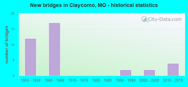
- New bridges - historical statistics
- 121950-1959
- 171960-1969
- 21990-1999
- 22000-2009
- 42010-2019

- Reconstructed bridges - Historical Statistics
- 31980-1989
- 01990-1999
- 32000-2009
- 22010-2019


- Bridge Condition - Deck
- 20.0%Very good
- 33.3%Good
- 46.7%Satisfactory

- Bridge Condition - Superstructure
- 13.3%Excellent
- 53.3%Good
- 33.3%Satisfactory

- Bridge Condition - Substructure
- 13.3%Excellent
- 13.3%Very good
- 20.0%Good
- 46.7%Satisfactory
- 6.7%Fair

- Bridge Condition - Channel
- 14.3%Very good
- 42.9%Good
- 28.6%Satisfactory
- 14.3%Fair
Find on map >> Show street view
Structure Number: 1271, Location: S 27 T 51 N R 32 W (Lat: 39.206039, Lng: -94.492958), Route carried "on" structure: Ramp State highway , Year Built: 1969, Year Reconstructed: 1986, Status: Open, Structure Length: 7.65m (25.10ft), Average Daily Traffic: 13,556 (year 2021), Truck Traffic: 16%, Average Future Daily Traffic: 24,401 (year 2041), Design Load: HS 20, Features Intersected: IS 35, Facility Carried by Structure: RP IS35S TO IS435S
Minimum Vertical Clearance: 4.83m (15.85ft), Kilometerpoint: 0.515, Lanes on structure: 1, Lanes under structure: 5, Base Highway Network: Yes, Owner: State Highway Agency, Approaching Roadway Width: 7.3m (24.0ft), Skew: 5 degrees, Material/Design: Concrete continuous, Design/Construction: Slab, Number Of Spans In Main Unit: 4, Length of Maximum Span: 21.9m (71.9ft), Curb-To-Curb Width: 7.3m (24.0ft), Out-to-Out Width: 8.2m (26.9ft)
Condition: Deck: Satisfactory, Superstructure: Satisfactory, Substructure: Very good, Operating Rating: 73.8 metric tons, Method Used To Determine Operating Rating: Load Factor (LF), Inventory Rating: 32.4 metric tons, Method Used To Determine Inventory Rating: Load Factor (LF), Structural Evaluation: Equal to present minimum criteria, Deck Geometry: Somewhat better than minimum adequacy, Underclear: High priority of corrective action, Approach Roadway Alignment: Equal to present desirable criteria, Designated Inspection Frequency: Every 24 months, Inspection Date: September 2020, Deck Structure Type: Concrete Cast-file-Place, Wearing Surface/Protective System: Wearing Surface: Low Slump Concrete
Find on map >> Show street view
Structure Number: 1272, Location: S 27 T 51 N R 32 W (Lat: 39.205686, Lng: -94.492714), Route carried "on" structure: Ramp State highway , Year Built: 1969, Year Reconstructed: 2013, Status: Posted for load, Structure Length: 22.13m (72.60ft), Average Daily Traffic: 1,992 (year 2021), Truck Traffic: 10%, Average Future Daily Traffic: 3,586 (year 2041), Design Load: HS 20, Features Intersected: IS 35, IS 435, Facility Carried by Structure: RP IS435N TO IS35S
Minimum Vertical Clearance: 30+ m (98+ ft), Kilometerpoint: 0.478, Lanes on structure: 2, Lanes under structure: 12, Base Highway Network: Yes, Owner: State Highway Agency, Approaching Roadway Width: 14.6m (47.9ft), Skew: 1 degrees, Material/Design: Concrete continuous, Design/Construction: Box Beam or Girders - Single/Spread, Number Of Spans In Main Unit: 9, Length of Maximum Span: 32.3m (106.0ft), Curb-To-Curb Width: 9.1m (29.9ft), Out-to-Out Width: 10.0m (32.8ft)
Condition: Deck: Satisfactory, Superstructure: Satisfactory, Substructure: Satisfactory, Operating Rating: 71.1 metric tons, Method Used To Determine Operating Rating: Load Factor (LF), Inventory Rating: 42.3 metric tons, Method Used To Determine Inventory Rating: Load Factor (LF), Structural Evaluation: Equal to present minimum criteria, Deck Geometry: Meets minimum limits, Underclear: High priority of corrective action, Approach Roadway Alignment: Equal to present desirable criteria, Designated Inspection Frequency: Every 24 months, Inspection Date: September 2020, Deck Structure Type: Concrete Cast-file-Place, Wearing Surface/Protective System: Wearing Surface: Low Slump Concrete
Find on map >> Show street view
Structure Number: 1273, Location: S 27 T 51 N R 32 W (Lat: 39.204375, Lng: -94.491569), Route carried "on" structure: Ramp State highway , Year Built: 1969, Year Reconstructed: 1986, Status: Open, Structure Length: 6.64m (21.78ft), Average Daily Traffic: 1,718 (year 2021), Truck Traffic: 18%, Average Future Daily Traffic: 3,092 (year 2041), Design Load: H 20, Features Intersected: RP IS435N TO IS35N, Facility Carried by Structure: RP US69S TO IS35S
Minimum Vertical Clearance: 30+ m (98+ ft), Kilometerpoint: 0.095, Lanes on structure: 1, Lanes under structure: 1, Base Highway Network: Yes, Owner: State Highway Agency, Approaching Roadway Width: 9.1m (29.9ft), Skew: 4 degrees, Material/Design: Concrete continuous, Design/Construction: Slab, Number Of Spans In Main Unit: 4, Length of Maximum Span: 19.2m (63.0ft), Curb-To-Curb Width: 7.3m (24.0ft), Out-to-Out Width: 8.1m (26.6ft)
Condition: Deck: Satisfactory, Superstructure: Satisfactory, Substructure: Satisfactory, Operating Rating: 57.6 metric tons, Method Used To Determine Operating Rating: Load Factor (LF), Inventory Rating: 35.1 metric tons, Method Used To Determine Inventory Rating: Load Factor (LF), Structural Evaluation: Equal to present minimum criteria, Deck Geometry: Better than present minimum criteria, Underclear: Equal to present minimum criteria, Approach Roadway Alignment: Equal to present desirable criteria, Designated Inspection Frequency: Every 24 months, Inspection Date: September 2020, Deck Structure Type: Concrete Cast-file-Place, Wearing Surface/Protective System: Wearing Surface: Low Slump Concrete, Deck Protection: Cathodic Protection
Find on map >> Show street view
Structure Number: 1275, Location: S 27 T 51 N R 32 W (Lat: 39.202769, Lng: -94.492197), Route carried "on" structure: Ramp State highway , Year Built: 1969, Year Reconstructed: 1986, Status: Open, Structure Length: 6.89m (22.60ft), Average Daily Traffic: 12,855 (year 2021), Truck Traffic: 19%, Average Future Daily Traffic: 23,139 (year 2041), Design Load: HS 20, Features Intersected: US 69, Facility Carried by Structure: RP IS435N TO IS35N
Minimum Vertical Clearance: 30+ m (98+ ft), Kilometerpoint: 0.172, Lanes on structure: 2, Lanes under structure: 4, Base Highway Network: Yes, Owner: State Highway Agency, Approaching Roadway Width: 17.1m (56.1ft), Skew: 3 degrees, Material/Design: Concrete continuous, Design/Construction: Slab, Number Of Spans In Main Unit: 4, Length of Maximum Span: 21.2m (69.6ft), Curb-To-Curb Width: 12.8m (42.0ft), Out-to-Out Width: 14.6m (47.9ft)
Condition: Deck: Satisfactory, Superstructure: Satisfactory, Substructure: Satisfactory, Operating Rating: 75.6 metric tons, Method Used To Determine Operating Rating: Load Factor (LF), Inventory Rating: 45.0 metric tons, Method Used To Determine Inventory Rating: Load Factor (LF), Structural Evaluation: Equal to present minimum criteria, Deck Geometry: Superior to present desirable criteria, Underclear: Somewhat better than minimum adequacy, Approach Roadway Alignment: Equal to present desirable criteria, Designated Inspection Frequency: Every 24 months, Inspection Date: September 2020, Deck Structure Type: Concrete Cast-file-Place, Wearing Surface/Protective System: Wearing Surface: Low Slump Concrete
Find on map >> Show street view
Structure Number: 29198, Location: S 28 T 51 N R 32 W (Lat: 39.200019, Lng: -94.493361), Route carried "on" structure: City street 151, Year Built: 2001, Status: Open, Structure Length: 2.47m (8.10ft), Average Daily Traffic: 2,400 (year 2020), Truck Traffic: 5%, Average Future Daily Traffic: 3,840 (year 2040), Features Intersected: THORNTON MILL CR, Facility Carried by Structure: RANDOLPH RD
Minimum Vertical Clearance: 30+ m (98+ ft), Kilometerpoint: 0.322, Lanes on structure: 2, Owner: City or Municipal Highway Agency, Approaching Roadway Width: 6.7m (22.0ft), Material/Design: Steel, Design/Construction: Stringer/Multi-beam, Number Of Spans In Main Unit: 1, Length of Maximum Span: 24.4m (80.1ft), Curb or Sidewalk Widths: Left: 1.5m (4.9ft), Right: 0.0m, Curb-To-Curb Width: 8.5m (27.9ft), Out-to-Out Width: 10.9m (35.8ft)
Condition: Deck: Very good, Superstructure: Good, Substructure: Satisfactory, Channel: Good, Operating Rating: 63.9 metric tons, Method Used To Determine Operating Rating: Load Factor (LF), Inventory Rating: 37.8 metric tons, Method Used To Determine Inventory Rating: Load Factor (LF), Structural Evaluation: Equal to present minimum criteria, Deck Geometry: Meets minimum limits, Waterway Adequacy: Better than present minimum criteria, Approach Roadway Alignment: Equal to present desirable criteria, Designated Inspection Frequency: Every 24 months, Inspection Date: December 2021, Deck Structure Type: Concrete Cast-file-Place, Wearing Surface/Protective System: Wearing Surface: Monolithic Concrete
Find on map >> Show street view
Structure Number: 29199, Location: S 28 T 51 N R 32 W (Lat: 39.200267, Lng: -94.505536), Route carried "on" structure: City street 151, Year Built: 2001, Status: Open, Structure Length: 1.55m (5.09ft), Average Daily Traffic: 400 (year 2020), Truck Traffic: 5%, Average Future Daily Traffic: 640 (year 2040), Features Intersected: THORNTON MILL CR, Facility Carried by Structure: POE ST
Minimum Vertical Clearance: 30+ m (98+ ft), Kilometerpoint: 0.161, Lanes on structure: 2, Owner: City or Municipal Highway Agency, Approaching Roadway Width: 7.3m (24.0ft), Material/Design: Steel, Design/Construction: Stringer/Multi-beam, Number Of Spans In Main Unit: 1, Length of Maximum Span: 14.9m (48.9ft), Curb-To-Curb Width: 7.3m (24.0ft), Out-to-Out Width: 11.3m (37.1ft)
Condition: Deck: Good, Superstructure: Good, Substructure: Good, Channel: Fair, Operating Rating: 54.0 metric tons, Method Used To Determine Operating Rating: Load Factor (LF), Inventory Rating: 32.4 metric tons, Method Used To Determine Inventory Rating: Load Factor (LF), Structural Evaluation: Better than present minimum criteria, Deck Geometry: Somewhat better than minimum adequacy, Waterway Adequacy: Equal to present minimum criteria, Approach Roadway Alignment: Equal to present desirable criteria, Designated Inspection Frequency: Every 24 months, Inspection Date: December 2021, Deck Structure Type: Concrete Cast-file-Place, Wearing Surface/Protective System: Wearing Surface: Monolithic Concrete
Find on map >> Show street view
Structure Number: 34892, Location: S 28 T 51 N R 32 W (Lat: 39.201058, Lng: -94.506064), Route carried "on" structure: Interstate 35, Year Built: 2015, Status: Open, Structure Length: 2.32m (7.61ft), Average Daily Traffic: 28,618 (year 2021), Truck Traffic: 18%, Average Future Daily Traffic: 51,512 (year 2041), Features Intersected: CST POE AVE
Minimum Vertical Clearance: 30+ m (98+ ft), Kilometerpoint: 19.906, Lanes on structure: 2, Lanes under structure: 2, Base Highway Network: Yes, Owner: State Highway Agency, Approaching Roadway Width: 15.1m (49.5ft), Skew: 1 degrees, Material/Design: Prestressed concrete, Design/Construction: Box Beam or Girders - Single/Spread, Number Of Spans In Main Unit: 1, Length of Maximum Span: 21.9m (71.9ft), Curb-To-Curb Width: 15.1m (49.5ft), Out-to-Out Width: 15.9m (52.2ft)
Condition: Deck: Very good, Superstructure: Excellent, Substructure: Excellent, Operating Rating: 97.2 metric tons, Method Used To Determine Operating Rating: Load Factor (LF), Inventory Rating: 46.8 metric tons, Method Used To Determine Inventory Rating: Load Factor (LF), Structural Evaluation: Superior to present desirable criteria, Deck Geometry: Superior to present desirable criteria, Underclear: Better than present minimum criteria, Approach Roadway Alignment: Equal to present desirable criteria, Designated Inspection Frequency: Every 24 months, Inspection Date: September 2020, Deck Structure Type: Concrete Cast-file-Place, Wearing Surface/Protective System: Wearing Surface: Monolithic Concrete, Deck Protection: Epoxy Coated Reinforcing
Find on map >> Show street view
Structure Number: 34894, Location: S 28 T 51 N R 32 W (Lat: 39.201228, Lng: -94.506181), Route carried "on" structure: Interstate 35, Year Built: 2015, Status: Open, Structure Length: 2.32m (7.61ft), Average Daily Traffic: 31,371 (year 2021), Truck Traffic: 18%, Average Future Daily Traffic: 56,468 (year 2041), Features Intersected: CST POE AVE
Minimum Vertical Clearance: 30+ m (98+ ft), Kilometerpoint: 164.198, Lanes on structure: 3, Lanes under structure: 2, Base Highway Network: Yes, Owner: State Highway Agency, Approaching Roadway Width: 15.1m (49.5ft), Skew: 1 degrees, Material/Design: Prestressed concrete, Design/Construction: Box Beam or Girders - Single/Spread, Number Of Spans In Main Unit: 1, Length of Maximum Span: 21.9m (71.9ft), Curb-To-Curb Width: 15.1m (49.5ft), Out-to-Out Width: 15.9m (52.2ft)
Condition: Deck: Very good, Superstructure: Excellent, Substructure: Excellent, Operating Rating: 97.2 metric tons, Method Used To Determine Operating Rating: Load Factor (LF), Inventory Rating: 46.8 metric tons, Method Used To Determine Inventory Rating: Load Factor (LF), Structural Evaluation: Superior to present desirable criteria, Deck Geometry: Meets minimum limits, Underclear: Better than present minimum criteria, Approach Roadway Alignment: Equal to present desirable criteria, Designated Inspection Frequency: Every 24 months, Inspection Date: September 2020, Deck Structure Type: Concrete Cast-file-Place, Wearing Surface/Protective System: Wearing Surface: Monolithic Concrete, Deck Protection: Epoxy Coated Reinforcing
Find on map >> Show street view
Structure Number: 4343, Location: S 28 T 51 N R 32 W (Lat: 39.198969, Lng: -94.501789), Route carried "on" structure: US 69, Year Built: 1996, Status: Open, Structure Length: 3.81m (12.50ft), Average Daily Traffic: 13,139 (year 2021), Truck Traffic: 3%, Average Future Daily Traffic: 21,022 (year 2041), Design Load: HS 25 or greater, Features Intersected: THORNTON MILL CR
Minimum Vertical Clearance: 30+ m (98+ ft), Kilometerpoint: 181.301, Lanes on structure: 5, Owner: State Highway Agency, Approaching Roadway Width: 18.3m (60.0ft), Skew: 2 degrees, Material/Design: Prestressed concrete continuous, Design/Construction: Stringer/Multi-beam, Number Of Spans In Main Unit: 3, Length of Maximum Span: 16.5m (54.1ft), Curb or Sidewalk Widths: Left: 1.6m (5.2ft), Right: 1.6m (5.2ft), Curb-To-Curb Width: 19.7m (64.6ft), Out-to-Out Width: 23.9m (78.4ft)
Condition: Deck: Good, Superstructure: Good, Substructure: Very good, Channel: Satisfactory, Operating Rating: 77.4 metric tons, Method Used To Determine Operating Rating: Load Factor (LF), Inventory Rating: 46.8 metric tons, Method Used To Determine Inventory Rating: Load Factor (LF), Structural Evaluation: Better than present minimum criteria, Deck Geometry: Meets minimum limits, Waterway Adequacy: Equal to present desirable criteria, Approach Roadway Alignment: Equal to present desirable criteria, Designated Inspection Frequency: Every 24 months, Inspection Date: September 2020, Deck Structure Type: Concrete Cast-file-Place, Wearing Surface/Protective System: Wearing Surface: Monolithic Concrete, Deck Protection: Epoxy Coated Reinforcing
Find on map >> Show street view
Structure Number: 4344, Location: S 27 T 51 N R 32 W (Lat: 39.207681, Lng: -94.479847), Route carried "on" structure: US 69, Year Built: 1996, Status: Open, Structure Length: 6.25m (20.51ft), Average Daily Traffic: 10,376 (year 2021), Truck Traffic: 14%, Average Future Daily Traffic: 16,602 (year 2041), Design Load: HS 25 or greater, Features Intersected: SHOAL CR
Minimum Vertical Clearance: 30+ m (98+ ft), Kilometerpoint: 179.156, Lanes on structure: 5, Owner: State Highway Agency, Approaching Roadway Width: 18.3m (60.0ft), Skew: 2 degrees, Material/Design: Prestressed concrete continuous, Design/Construction: Stringer/Multi-beam, Number Of Spans In Main Unit: 3, Length of Maximum Span: 23.3m (76.4ft), Curb or Sidewalk Widths: Left: 0.2m (0.7ft), Right: 0.2m (0.7ft), Curb-To-Curb Width: 23.2m (76.1ft), Out-to-Out Width: 24.0m (78.7ft)
Condition: Deck: Good, Superstructure: Good, Substructure: Good, Channel: Satisfactory, Operating Rating: 79.2 metric tons, Method Used To Determine Operating Rating: Load Factor (LF), Inventory Rating: 46.8 metric tons, Method Used To Determine Inventory Rating: Load Factor (LF), Structural Evaluation: Better than present minimum criteria, Deck Geometry: Better than present minimum criteria, Waterway Adequacy: Equal to present minimum criteria, Approach Roadway Alignment: Equal to present desirable criteria, Designated Inspection Frequency: Every 24 months, Inspection Date: September 2020, Deck Structure Type: Concrete Cast-file-Place, Wearing Surface/Protective System: Wearing Surface: Monolithic Concrete, Deck Protection: Epoxy Coated Reinforcing
Find on map >> Show street view
Structure Number: 6309, Location: S 28 T 51 N R 32 W (Lat: 39.200589, Lng: -94.506897), Route carried "on" structure: Interstate 35, Year Built: 1958, Status: Open, Structure Length: 1.03m (3.38ft), Average Daily Traffic: 59,989 (year 2021), Truck Traffic: 18%, Average Future Daily Traffic: 107,980 (year 2041), Design Load: HS 20, Features Intersected: MILL CR
Minimum Vertical Clearance: 30+ m (98+ ft), Kilometerpoint: 164.301, Lanes on structure: 4, Base Highway Network: Yes, Owner: State Highway Agency, Approaching Roadway Width: 30.5m (100.1ft), Skew: 22 degrees, Material/Design: Concrete continuous, Design/Construction: Culvert, Number Of Spans In Main Unit: 2, Length of Maximum Span: 4.9m (16.1ft)
Condition: Channel: Good, Culverts: Good, Operating Rating: 72.0 metric tons, Method Used To Determine Operating Rating: Field evaluation and documented engineering judgment, Inventory Rating: 43.2 metric tons, Method Used To Determine Inventory Rating: Field evaluation and documented engineering judgment, Structural Evaluation: Better than present minimum criteria, Waterway Adequacy: Equal to present minimum criteria, Approach Roadway Alignment: Equal to present desirable criteria, Designated Inspection Frequency: Every 24 months, Inspection Date: November 2020
Find on map >> Show street view
Structure Number: 631, Location: S 27 T 51 N R 32 W (Lat: 39.209772, Lng: -94.484331), Route carried "on" structure: Interstate 35, Year Built: 1958, Year Reconstructed: 2015, Status: Open, Structure Length: 6.31m (20.70ft), Average Daily Traffic: 32,449 (year 2021), Truck Traffic: 16%, Average Future Daily Traffic: 58,408 (year 2041), Design Load: HS 20+Mod, Features Intersected: BIG SHOAL CR
Minimum Vertical Clearance: 30+ m (98+ ft), Kilometerpoint: 162.052, Lanes on structure: 3, Base Highway Network: Yes, Owner: State Highway Agency, Approaching Roadway Width: 15.1m (49.5ft), Skew: 3 degrees, Material/Design: Steel continuous, Design/Construction: Stringer/Multi-beam, Number Of Spans In Main Unit: 3, Length of Maximum Span: 23.2m (76.1ft), Curb-To-Curb Width: 15.1m (49.5ft), Out-to-Out Width: 15.9m (52.2ft)
Condition: Deck: Good, Superstructure: Good, Substructure: Satisfactory, Channel: Good, Operating Rating: 45.0 metric tons, Method Used To Determine Operating Rating: Load Factor (LF), Inventory Rating: 27.0 metric tons, Method Used To Determine Inventory Rating: Load Factor (LF), Structural Evaluation: Equal to present minimum criteria, Deck Geometry: Meets minimum limits, Waterway Adequacy: Equal to present desirable criteria, Approach Roadway Alignment: Equal to present desirable criteria, Designated Inspection Frequency: Every 24 months, Inspection Date: September 2020, Deck Structure Type: Concrete Cast-file-Place, Wearing Surface/Protective System: Wearing Surface: Monolithic Concrete, Deck Protection: Epoxy Coated Reinforcing
Find on map >> Show street view
Structure Number: 6311, Location: S 27 T 51 N R 32 W (Lat: 39.209725, Lng: -94.484069), Route carried "on" structure: Interstate 35, Year Built: 1958, Year Reconstructed: 2015, Status: Open, Structure Length: 6.31m (20.70ft), Average Daily Traffic: 30,578 (year 2021), Truck Traffic: 18%, Average Future Daily Traffic: 55,040 (year 2041), Design Load: HS 20+Mod, Features Intersected: BIG SHOAL CR
Minimum Vertical Clearance: 30+ m (98+ ft), Kilometerpoint: 22.038, Lanes on structure: 3, Base Highway Network: Yes, Owner: State Highway Agency, Approaching Roadway Width: 15.1m (49.5ft), Skew: 3 degrees, Material/Design: Steel continuous, Design/Construction: Stringer/Multi-beam, Number Of Spans In Main Unit: 3, Length of Maximum Span: 23.2m (76.1ft), Curb-To-Curb Width: 15.1m (49.5ft), Out-to-Out Width: 15.9m (52.2ft)
Condition: Deck: Good, Superstructure: Good, Substructure: Satisfactory, Channel: Very good, Operating Rating: 45.0 metric tons, Method Used To Determine Operating Rating: Load Factor (LF), Inventory Rating: 27.0 metric tons, Method Used To Determine Inventory Rating: Load Factor (LF), Structural Evaluation: Equal to present minimum criteria, Deck Geometry: Meets minimum limits, Waterway Adequacy: Equal to present desirable criteria, Approach Roadway Alignment: Equal to present desirable criteria, Designated Inspection Frequency: Every 24 months, Inspection Date: September 2020, Deck Structure Type: Concrete Cast-file-Place, Wearing Surface/Protective System: Wearing Surface: Monolithic Concrete, Deck Protection: Epoxy Coated Reinforcing
Find on map >> Show street view
Structure Number: 6487, Location: S 28 T 51 N R 32 W (Lat: 39.203792, Lng: -94.500669), Route carried "on" structure: City street , Year Built: 1958, Status: Posted for load, Structure Length: 5.85m (19.19ft), Average Daily Traffic: 3,416 (year 2021), Truck Traffic: 5%, Average Future Daily Traffic: 5,295 (year 2041), Design Load: H 15, Features Intersected: IS 35, Facility Carried by Structure: BRYANT ST S
Minimum Vertical Clearance: 30+ m (98+ ft), Kilometerpoint: 0.262, Lanes on structure: 2, Lanes under structure: 6, Owner: State Highway Agency, Approaching Roadway Width: 7.3m (24.0ft), Material/Design: Steel continuous, Design/Construction: Stringer/Multi-beam, Number Of Spans In Main Unit: 4, Length of Maximum Span: 15.8m (51.8ft), Curb or Sidewalk Widths: Left: 1.2m (3.9ft), Right: 1.2m (3.9ft), Curb-To-Curb Width: 7.9m (25.9ft), Out-to-Out Width: 11.0m (36.1ft)
Condition: Deck: Satisfactory, Superstructure: Satisfactory, Substructure: Fair, Operating Rating: 37.8 metric tons, Method Used To Determine Operating Rating: Allowable Stress (AS), Inventory Rating: 18.9 metric tons, Method Used To Determine Inventory Rating: Allowable Stress (AS), Structural Evaluation: Somewhat better than minimum adequacy, Deck Geometry: High priority of corrective action, Underclear: Meets minimum limits, Approach Roadway Alignment: Equal to present desirable criteria, Length Of Structure Improvement: 0.69m (2.26ft), Designated Inspection Frequency: Every 24 months, Inspection Date: September 2020, Bridge Improvement Cost: $786,000, Roadway Improvement Cost: $79,000, Total Project Cost: $1,180,000 ( Estimate for 2022), Deck Structure Type: Concrete Cast-file-Place, Wearing Surface/Protective System: Wearing Surface: Bituminous
Find on map >> Show street view
Structure Number: 6488, Location: S 32 T 51 N R 32 W (Lat: 39.188372, Lng: -94.516119), Route carried "on" structure: US 69, Year Built: 1958, Year Reconstructed: 2007, Status: Posted for load, Structure Length: 7.92m (25.98ft), Average Daily Traffic: 6,707 (year 2021), Truck Traffic: 3%, Average Future Daily Traffic: 10,731 (year 2041), Design Load: H 20, Features Intersected: IS 35
Minimum Vertical Clearance: 30+ m (98+ ft), Kilometerpoint: 182.991, Lanes on structure: 2, Lanes under structure: 4, Owner: State Highway Agency, Approaching Roadway Width: 7.3m (24.0ft), Skew: 3 degrees, Material/Design: Steel continuous, Design/Construction: Stringer/Multi-beam, Number Of Spans In Main Unit: 4, Length of Maximum Span: 21.6m (70.9ft), Curb-To-Curb Width: 8.5m (27.9ft), Out-to-Out Width: 10.1m (33.1ft)
Condition: Deck: Satisfactory, Superstructure: Good, Substructure: Satisfactory, Operating Rating: 54.0 metric tons, Method Used To Determine Operating Rating: Load Factor (LF), Inventory Rating: 32.4 metric tons, Method Used To Determine Inventory Rating: Load Factor (LF), Structural Evaluation: Equal to present minimum criteria, Deck Geometry: High priority of corrective action, Underclear: Meets minimum limits, Approach Roadway Alignment: Equal to present desirable criteria, Length Of Structure Improvement: 0.89m (2.92ft), Designated Inspection Frequency: Every 24 months, Inspection Date: September 2020, Bridge Improvement Cost: $691,000, Roadway Improvement Cost: $69,000, Total Project Cost: $1,036,000 ( Estimate for 2022), Deck Structure Type: Concrete Cast-file-Place, Wearing Surface/Protective System: Wearing Surface: Monolithic Concrete, Deck Protection: Epoxy Coated Reinforcing
Find on map >> Show street view
Structure Number: 6489, Location: S 32 T 51 N R 32 W (Lat: 39.188197, Lng: -94.516150), Route carried "on" structure: US 69, Year Built: 1958, Year Reconstructed: 2007, Status: Open, Structure Length: 8.35m (27.40ft), Average Daily Traffic: 6,165 (year 2021), Truck Traffic: 4%, Average Future Daily Traffic: 9,864 (year 2041), Design Load: H 20, Features Intersected: IS 35
Minimum Vertical Clearance: 30+ m (98+ ft), Kilometerpoint: 12.841, Lanes on structure: 2, Lanes under structure: 4, Owner: State Highway Agency, Approaching Roadway Width: 7.3m (24.0ft), Skew: 3 degrees, Material/Design: Steel continuous, Design/Construction: Stringer/Multi-beam, Number Of Spans In Main Unit: 4, Length of Maximum Span: 23.7m (77.8ft), Curb-To-Curb Width: 8.5m (27.9ft), Out-to-Out Width: 10.1m (33.1ft)
Condition: Deck: Satisfactory, Superstructure: Good, Substructure: Good, Operating Rating: 54.0 metric tons, Method Used To Determine Operating Rating: Load Factor (LF), Inventory Rating: 32.4 metric tons, Method Used To Determine Inventory Rating: Load Factor (LF), Structural Evaluation: Better than present minimum criteria, Deck Geometry: High priority of corrective action, Underclear: Meets minimum limits, Approach Roadway Alignment: Equal to present desirable criteria, Length Of Structure Improvement: 0.93m (3.05ft), Designated Inspection Frequency: Every 24 months, Inspection Date: September 2020, Bridge Improvement Cost: $722,000, Roadway Improvement Cost: $72,000, Total Project Cost: $1,082,000 ( Estimate for 2022), Deck Structure Type: Concrete Cast-file-Place, Wearing Surface/Protective System: Wearing Surface: Monolithic Concrete, Deck Protection: Epoxy Coated Reinforcing
Find on map >> Show street view
Structure Number: 1271, Location: S 27 T 51 N R 32 W (Lat: 39.206039, Lng: -94.492958), Route carried "under" structure: Interstate 35, Year Built: 1969, Structure Length: 0. m, Average Daily Traffic: 28,618 (year 2021), Truck Traffic: 18%, Features Intersected: IS 35
Minimum Vertical Clearance: 4.90m (16.08ft), Kilometerpoint: 21.177, Lanes on structure: 1, Lanes under structure: 3, Material/Design: Concrete continuous, Design/Construction: Slab, Length of Maximum Span: 21.9m (71.9ft)
Find on map >> Show street view
Structure Number: 1271, Location: S 27 T 51 N R 32 W (Lat: 39.206039, Lng: -94.492958), Route carried "under" structure: Interstate 35, Year Built: 1969, Structure Length: 0. m, Average Daily Traffic: 31,371 (year 2021), Truck Traffic: 18%, Features Intersected: IS 35
Minimum Vertical Clearance: 4.85m (15.91ft), Kilometerpoint: 162.930, Lanes on structure: 1, Lanes under structure: 2, Material/Design: Concrete continuous, Design/Construction: Slab, Length of Maximum Span: 21.9m (71.9ft)
Find on map >> Show street view
Structure Number: 1272, Location: S 27 T 51 N R 32 W (Lat: 39.205686, Lng: -94.492714), Route carried "under" structure: Interstate 435, Year Built: 1969, Structure Length: 0. m, Average Daily Traffic: 30,465 (year 2021), Truck Traffic: 19%, Features Intersected: IS 435
Minimum Vertical Clearance: 5.33m (17.49ft), Kilometerpoint: 37.622, Lanes on structure: 2, Lanes under structure: 2, Material/Design: Concrete continuous, Design/Construction: Box Beam or Girders - Single/Spread, Length of Maximum Span: 32.3m (106.0ft)
Find on map >> Show street view
Structure Number: 1272, Location: S 27 T 51 N R 32 W (Lat: 39.205686, Lng: -94.492714), Route carried "under" structure: Ramp State highway , Year Built: 1969, Structure Length: 0. m, Average Daily Traffic: 13,556 (year 2021), Truck Traffic: 16%, Features Intersected: RP IS35S TO IS435S, Facility Carried by Structure: RP IS435N TO IS35S
Minimum Vertical Clearance: 5.05m (16.57ft), Kilometerpoint: 0.562, Lanes on structure: 2, Lanes under structure: 1, Material/Design: Concrete continuous, Design/Construction: Box Beam or Girders - Single/Spread, Length of Maximum Span: 32.3m (106.0ft)
Find on map >> Show street view
Structure Number: 1272, Location: S 27 T 51 N R 32 W (Lat: 39.205686, Lng: -94.492714), Route carried "under" structure: Interstate 435, Year Built: 1969, Structure Length: 0. m, Average Daily Traffic: 29,501 (year 2021), Truck Traffic: 15%, Features Intersected: IS 435
Minimum Vertical Clearance: 5.05m (16.57ft), Kilometerpoint: 51.227, Lanes on structure: 2, Lanes under structure: 2, Material/Design: Concrete continuous, Design/Construction: Box Beam or Girders - Single/Spread, Length of Maximum Span: 32.3m (106.0ft)
Find on map >> Show street view
Structure Number: 1272, Location: S 27 T 51 N R 32 W (Lat: 39.205686, Lng: -94.492714), Route carried "under" structure: Ramp State highway , Year Built: 1969, Structure Length: 0. m, Average Daily Traffic: 2,300 (year 2021), Truck Traffic: 18%, Features Intersected: RP IS435S TO US69N, Facility Carried by Structure: RP IS435N TO IS35S
Minimum Vertical Clearance: 5.11m (16.77ft), Kilometerpoint: 0.581, Lanes on structure: 2, Lanes under structure: 1, Material/Design: Concrete continuous, Design/Construction: Box Beam or Girders - Single/Spread, Length of Maximum Span: 32.3m (106.0ft)
Find on map >> Show street view
Structure Number: 1272, Location: S 27 T 51 N R 32 W (Lat: 39.205686, Lng: -94.492714), Route carried "under" structure: Interstate 35, Year Built: 1969, Structure Length: 0. m, Average Daily Traffic: 31,371 (year 2021), Truck Traffic: 18%, Features Intersected: IS 35
Minimum Vertical Clearance: 10.06m (33.01ft), Kilometerpoint: 162.953, Lanes on structure: 2, Lanes under structure: 3, Material/Design: Concrete continuous, Design/Construction: Box Beam or Girders - Single/Spread, Length of Maximum Span: 32.3m (106.0ft)
Find on map >> Show street view
Structure Number: 1272, Location: S 27 T 51 N R 32 W (Lat: 39.205686, Lng: -94.492714), Route carried "under" structure: Interstate 35, Year Built: 1969, Structure Length: 0. m, Average Daily Traffic: 28,618 (year 2021), Truck Traffic: 18%, Features Intersected: IS 35
Minimum Vertical Clearance: 10.06m (33.01ft), Kilometerpoint: 21.189, Lanes on structure: 2, Lanes under structure: 3, Material/Design: Concrete continuous, Design/Construction: Box Beam or Girders - Single/Spread, Length of Maximum Span: 32.3m (106.0ft)
Find on map >> Show street view
Structure Number: 1273, Location: S 27 T 51 N R 32 W (Lat: 39.204375, Lng: -94.491569), Route carried "under" structure: Ramp State highway , Year Built: 1969, Structure Length: 0. m, Average Daily Traffic: 12,855 (year 2021), Truck Traffic: 19%, Features Intersected: RP IS435N TO IS35N, Facility Carried by Structure: RP US69S TO IS35S
Minimum Vertical Clearance: 5.08m (16.67ft), Kilometerpoint: 0.447, Lanes on structure: 1, Lanes under structure: 1, Material/Design: Concrete continuous, Design/Construction: Slab, Length of Maximum Span: 19.2m (63.0ft)
Find on map >> Show street view
Structure Number: 1274, Location: S 27 T 51 N R 32 W (Lat: 39.202472, Lng: -94.492853), Route carried "under" structure: US 69, Year Built: 1969, Structure Length: 0. m, Average Daily Traffic: 6,168 (year 2021), Truck Traffic: 12%, Features Intersected: US 69, Facility Carried by Structure: RP IS35N TO IS435S
Minimum Vertical Clearance: 4.70m (15.42ft), Kilometerpoint: 15.509, Lanes on structure: 2, Lanes under structure: 2, Material/Design: Concrete continuous, Design/Construction: Slab, Length of Maximum Span: 18.3m (60.0ft)
Find on map >> Show street view
Structure Number: 1274, Location: S 27 T 51 N R 32 W (Lat: 39.202472, Lng: -94.492853), Route carried "under" structure: US 69, Year Built: 1969, Structure Length: 0. m, Average Daily Traffic: 5,431 (year 2021), Truck Traffic: 15%, Features Intersected: US 69, Facility Carried by Structure: RP IS35N TO IS435S
Minimum Vertical Clearance: 4.72m (15.49ft), Kilometerpoint: 180.450, Lanes on structure: 2, Lanes under structure: 3, Material/Design: Concrete continuous, Design/Construction: Slab, Length of Maximum Span: 18.3m (60.0ft)
Find on map >> Show street view
Structure Number: 1275, Location: S 27 T 51 N R 32 W (Lat: 39.202769, Lng: -94.492197), Route carried "under" structure: US 69, Year Built: 1969, Structure Length: 0. m, Average Daily Traffic: 5,377 (year 2021), Truck Traffic: 13%, Features Intersected: US 69, Facility Carried by Structure: RP IS435N TO IS35N
Minimum Vertical Clearance: 4.78m (15.68ft), Kilometerpoint: 15.569, Lanes on structure: 2, Lanes under structure: 2, Material/Design: Concrete continuous, Design/Construction: Slab, Length of Maximum Span: 21.2m (69.6ft)
Find on map >> Show street view
Structure Number: 1275, Location: S 27 T 51 N R 32 W (Lat: 39.202769, Lng: -94.492197), Route carried "under" structure: US 69, Year Built: 1969, Structure Length: 0. m, Average Daily Traffic: 4,999 (year 2021), Truck Traffic: 14%, Features Intersected: US 69, Facility Carried by Structure: RP IS435N TO IS35N
Minimum Vertical Clearance: 4.80m (15.75ft), Kilometerpoint: 180.387, Lanes on structure: 2, Lanes under structure: 2, Material/Design: Concrete continuous, Design/Construction: Slab, Length of Maximum Span: 21.2m (69.6ft)
Find on map >> Show street view
Structure Number: 34892, Location: S 28 T 51 N R 32 W (Lat: 39.201058, Lng: -94.506064), Route carried "under" structure: City street , Year Built: 2015, Structure Length: 0. m, Average Daily Traffic: 818 (year 2021), Truck Traffic: 5%, Features Intersected: CST POE AVE, Facility Carried by Structure: IS 35 N
Minimum Vertical Clearance: 4.80m (15.75ft), Kilometerpoint: 0.140, Lanes on structure: 2, Lanes under structure: 2, Material/Design: Prestressed concrete, Design/Construction: Box Beam or Girders - Single/Spread, Length of Maximum Span: 21.9m (71.9ft)
Find on map >> Show street view
Structure Number: 34894, Location: S 28 T 51 N R 32 W (Lat: 39.201228, Lng: -94.506181), Route carried "under" structure: City street , Year Built: 2015, Structure Length: 0. m, Average Daily Traffic: 818 (year 2021), Truck Traffic: 5%, Features Intersected: CST POE AVE, Facility Carried by Structure: IS 35 S
Minimum Vertical Clearance: 4.97m (16.31ft), Kilometerpoint: 0.117, Lanes on structure: 3, Lanes under structure: 2, Material/Design: Prestressed concrete, Design/Construction: Box Beam or Girders - Single/Spread, Length of Maximum Span: 21.9m (71.9ft)
Find on map >> Show street view
Structure Number: 6487, Location: S 28 T 51 N R 32 W (Lat: 39.203792, Lng: -94.500669), Route carried "under" structure: Interstate 35, Year Built: 1958, Structure Length: 0. m, Average Daily Traffic: 28,618 (year 2021), Truck Traffic: 18%, Features Intersected: IS 35, Facility Carried by Structure: BRYANT ST S
Minimum Vertical Clearance: 5.11m (16.77ft), Kilometerpoint: 20.469, Lanes on structure: 2, Lanes under structure: 3, Material/Design: Steel continuous, Design/Construction: Stringer/Multi-beam, Length of Maximum Span: 15.8m (51.8ft)
Find on map >> Show street view
Structure Number: 6487, Location: S 28 T 51 N R 32 W (Lat: 39.203792, Lng: -94.500669), Route carried "under" structure: Interstate 35, Year Built: 1958, Structure Length: 0. m, Average Daily Traffic: 31,371 (year 2021), Truck Traffic: 18%, Features Intersected: IS 35, Facility Carried by Structure: BRYANT ST S
Minimum Vertical Clearance: 4.90m (16.08ft), Kilometerpoint: 163.659, Lanes on structure: 2, Lanes under structure: 3, Material/Design: Steel continuous, Design/Construction: Stringer/Multi-beam, Length of Maximum Span: 15.8m (51.8ft)
Find on map >> Show street view
Structure Number: 6488, Location: S 32 T 51 N R 32 W (Lat: 39.188372, Lng: -94.516119), Route carried "under" structure: Interstate 35, Year Built: 1958, Structure Length: 0. m, Average Daily Traffic: 32,587 (year 2021), Truck Traffic: 18%, Features Intersected: IS 35, Facility Carried by Structure: US 69 S
Minimum Vertical Clearance: 5.94m (19.49ft), Kilometerpoint: 18.268, Lanes on structure: 2, Lanes under structure: 2, Material/Design: Steel continuous, Design/Construction: Stringer/Multi-beam, Length of Maximum Span: 21.6m (70.9ft)
Find on map >> Show street view
Structure Number: 6488, Location: S 32 T 51 N R 32 W (Lat: 39.188372, Lng: -94.516119), Route carried "under" structure: Interstate 35, Year Built: 1958, Structure Length: 0. m, Average Daily Traffic: 31,371 (year 2021), Truck Traffic: 18%, Features Intersected: IS 35, Facility Carried by Structure: US 69 S
Minimum Vertical Clearance: 5.11m (16.77ft), Kilometerpoint: 165.885, Lanes on structure: 2, Lanes under structure: 2, Material/Design: Steel continuous, Design/Construction: Stringer/Multi-beam, Length of Maximum Span: 21.6m (70.9ft)
Find on map >> Show street view
Structure Number: 6489, Location: S 32 T 51 N R 32 W (Lat: 39.188197, Lng: -94.516150), Route carried "under" structure: Interstate 35, Year Built: 1958, Structure Length: 0. m, Average Daily Traffic: 36,354 (year 2021), Truck Traffic: 18%, Features Intersected: IS 35, Facility Carried by Structure: US 69 N
Minimum Vertical Clearance: 5.03m (16.50ft), Kilometerpoint: 165.908, Lanes on structure: 2, Lanes under structure: 2, Material/Design: Steel continuous, Design/Construction: Stringer/Multi-beam, Length of Maximum Span: 23.7m (77.8ft)
Find on map >> Show street view
Structure Number: 6489, Location: S 32 T 51 N R 32 W (Lat: 39.188197, Lng: -94.516150), Route carried "under" structure: Interstate 35, Year Built: 1958, Structure Length: 0. m, Average Daily Traffic: 32,587 (year 2021), Truck Traffic: 18%, Features Intersected: IS 35, Facility Carried by Structure: US 69 N
Minimum Vertical Clearance: 6.02m (19.75ft), Kilometerpoint: 18.245, Lanes on structure: 2, Lanes under structure: 2, Material/Design: Steel continuous, Design/Construction: Stringer/Multi-beam, Length of Maximum Span: 23.7m (77.8ft)