Bridge Statistics for Clayton, Ohio (OH)
Condition, Traffic, Stress, Structural Evaluation, Project Costs
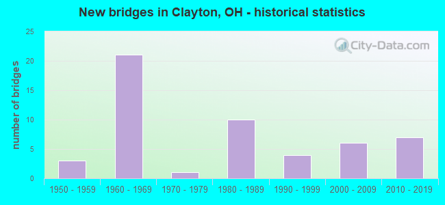
- New bridges - historical statistics
- 31950-1959
- 211960-1969
- 11970-1979
- 101980-1989
- 41990-1999
- 62000-2009
- 72010-2019

- Reconstructed bridges - Historical Statistics
- 51980-1989
- 31990-1999
- 22000-2009
- 32010-2019


- Bridge Condition - Deck
- 12.2%Excellent
- 17.1%Very good
- 46.3%Good
- 14.6%Satisfactory
- 4.9%Fair
- 4.9%Poor

- Bridge Condition - Superstructure
- 12.2%Excellent
- 29.3%Very good
- 36.6%Good
- 12.2%Satisfactory
- 4.9%Fair
- 4.9%Poor

- Bridge Condition - Substructure
- 12.2%Excellent
- 29.3%Very good
- 36.6%Good
- 17.1%Satisfactory
- 2.4%Fair
- 2.4%Poor

- Bridge Condition - Channel
- 17.6%Excellent
- 11.8%Very good
- 38.2%Good
- 23.5%Satisfactory
- 2.9%Fair
- 5.9%Poor

- Bridge Condition - Culverts
- 50.0%Excellent
- 50.0%Very good
Find on map >> Show street view
Structure Number: 570322, Location: .11 M. E. OF JCT. SR49 (Lat: 39.870831, Lng: -84.376669), Route carried "on" structure: US 40, Year Built: 2010, Status: Open, Structure Length: 1.83m (6.00ft), Average Daily Traffic: 8,583 (year 2015), Truck Traffic: 6%, Average Future Daily Traffic: 11,913 (year 2035), Design Load: HL 93, Features Intersected: NORTH BRANCH WOLF CREEK
Minimum Vertical Clearance: 30+ m (98+ ft), Kilometerpoint: 9.302, Lanes on structure: 2, Owner: State Highway Agency, Approaching Roadway Width: 9.1m (29.9ft), Skew: 1 degrees, Material/Design: Prestressed concrete, Design/Construction: Box Beam or Girders - Multiple, Number Of Spans In Main Unit: 1, Length of Maximum Span: 17.7m (58.1ft), Curb-To-Curb Width: 15.9m (52.2ft), Out-to-Out Width: 15.9m (52.2ft)
Condition: Deck: Excellent, Superstructure: Excellent, Substructure: Excellent, Channel: Excellent, Operating Rating: 81.0 metric tons, Method Used To Determine Operating Rating: Load Factor (LF) rating reported by rating factor (RF) method using MS18 loading, Inventory Rating: 77.8 metric tons, Method Used To Determine Inventory Rating: Load Factor (LF) rating reported by rating factor (RF) method using MS18 loading, Structural Evaluation: Superior to present desirable criteria, Deck Geometry: Superior to present desirable criteria, Waterway Adequacy: Equal to present desirable criteria, Approach Roadway Alignment: Equal to present desirable criteria, Designated Inspection Frequency: Every 24 months, Inspection Date: June 2021, Deck Structure Type: Concrete Cast-file-Place, Wearing Surface/Protective System: Wearing Surface: Monolithic Concrete, Deck Protection: Epoxy Coated Reinforcing
Find on map >> Show street view
Structure Number: 5704421, Location: .18MI.E.OF JCT.SB49&IR70 (Lat: 39.854061, Lng: -84.365750), Route carried "on" structure: Ramp State highway 49, Year Built: 2004, Status: Open, Structure Length: 1.87m (6.14ft), Average Daily Traffic: 3,541 (year 2015), Truck Traffic: 18%, Average Future Daily Traffic: 4,915 (year 2035), Design Load: HS 20+Mod, Features Intersected: RAZOR RUN
Minimum Vertical Clearance: 30+ m (98+ ft), Kilometerpoint: 16.979, Lanes on structure: 2, Owner: State Highway Agency, Approaching Roadway Width: 7.3m (24.0ft), Material/Design: Concrete continuous, Design/Construction: Slab, Number Of Spans In Main Unit: 3, Length of Maximum Span: 7.6m (24.9ft), Curb-To-Curb Width: 12.8m (42.0ft), Out-to-Out Width: 12.8m (42.0ft)
Condition: Deck: Very good, Superstructure: Very good, Substructure: Good, Channel: Excellent, Operating Rating: 42.1 metric tons, Method Used To Determine Operating Rating: Load Factor (LF) rating reported by rating factor (RF) method using MS18 loading, Inventory Rating: 32.4 metric tons, Method Used To Determine Inventory Rating: Load Factor (LF) rating reported by rating factor (RF) method using MS18 loading, Structural Evaluation: Better than present minimum criteria, Deck Geometry: Superior to present desirable criteria, Waterway Adequacy: Equal to present desirable criteria, Approach Roadway Alignment: Equal to present desirable criteria, Designated Inspection Frequency: Every 24 months, Inspection Date: July 2021, Deck Structure Type: Concrete Cast-file-Place, Wearing Surface/Protective System: Wearing Surface: Monolithic Concrete, Deck Protection: Epoxy Coated Reinforcing
Find on map >> Show street view
Structure Number: 5704448, Location: .08MI.E.OF JCT.SB49&IR70 (Lat: 39.853400, Lng: -84.367639), Route carried "on" structure: County highway C0217, Year Built: 1960, Year Reconstructed: 2004, Status: Open, Structure Length: 4.01m (13.16ft), Average Daily Traffic: 2,166 (year 2015), Truck Traffic: 5%, Average Future Daily Traffic: 4,915 (year 2035), Design Load: H 15, Features Intersected: S49*S, Facility Carried by Structure: DIAMOND MILL RD.
Minimum Vertical Clearance: 30+ m (98+ ft), Kilometerpoint: 23.335, Lanes on structure: 2, Lanes under structure: 2, Owner: State Highway Agency, Approaching Roadway Width: 5.5m (18.0ft), Skew: 1 degrees, Material/Design: Concrete continuous, Design/Construction: Slab, Number Of Spans In Main Unit: 3, Length of Maximum Span: 15.2m (49.9ft), Curb-To-Curb Width: 7.9m (25.9ft), Out-to-Out Width: 9.2m (30.2ft)
Condition: Deck: Satisfactory, Superstructure: Satisfactory, Substructure: Satisfactory, Operating Rating: 42.1 metric tons, Method Used To Determine Operating Rating: Load Factor (LF) rating reported by rating factor (RF) method using MS18 loading, Inventory Rating: 32.4 metric tons, Method Used To Determine Inventory Rating: Load Factor (LF) rating reported by rating factor (RF) method using MS18 loading, Structural Evaluation: Equal to present minimum criteria, Deck Geometry: High priority of corrective action, Underclear: High priority of corrective action, Approach Roadway Alignment: Equal to present desirable criteria, Designated Inspection Frequency: Every 12 months, Inspection Date: July 2021, Deck Structure Type: Concrete Cast-file-Place, Wearing Surface/Protective System: Wearing Surface: Bituminous
Find on map >> Show street view
Structure Number: 5704502, Location: JCT. IR-70 (Lat: 39.854569, Lng: -84.371711), Route carried "on" structure: State highway 49, Year Built: 1960, Year Reconstructed: 1994, Status: Open, Structure Length: 10.05m (32.97ft), Average Daily Traffic: 3,541 (year 2015), Truck Traffic: 18%, Average Future Daily Traffic: 4,915 (year 2035), Design Load: HS 20+Mod, Features Intersected: I70
Minimum Vertical Clearance: 30+ m (98+ ft), Kilometerpoint: 17.558, Lanes on structure: 3, Lanes under structure: 4, Base Highway Network: Yes (, Subroute: 1), Owner: State Highway Agency, Approaching Roadway Width: 9.8m (32.2ft), Skew: 3 degrees, Material/Design: Steel continuous, Design/Construction: Stringer/Multi-beam, Number Of Spans In Main Unit: 4, Length of Maximum Span: 26.2m (86.0ft), Curb-To-Curb Width: 11.5m (37.7ft), Out-to-Out Width: 12.9m (42.3ft)
Condition: Deck: Good, Superstructure: Very good, Substructure: Good, Operating Rating: 48.6 metric tons, Method Used To Determine Operating Rating: Load and Resistance Factor Rating (LRFR) rating reported by rating factor(RF) method using HL-93 loadings, Inventory Rating: 38.9 metric tons, Method Used To Determine Inventory Rating: Load and Resistance Factor Rating (LRFR) rating reported by rating factor(RF) method using HL-93 loadings, Structural Evaluation: Better than present minimum criteria, Deck Geometry: High priority of replacement, Underclear: Somewhat better than minimum adequacy, Approach Roadway Alignment: Superior to present desirable criteria, Designated Inspection Frequency: Every 24 months, Inspection Date: July 2021, Deck Structure Type: Concrete Cast-file-Place, Wearing Surface/Protective System: Wearing Surface: Monolithic Concrete, Deck Protection: Epoxy Coated Reinforcing
Find on map >> Show street view
Structure Number: 5704588, Location: .89MI.S. OF JCT. USR-40 (Lat: 39.858350, Lng: -84.375081), Route carried "on" structure: State highway 49, Year Built: 2017, Status: Open, Structure Length: 2.23m (7.32ft), Average Daily Traffic: 14,000 (year 2017), Truck Traffic: 12%, Average Future Daily Traffic: 16,380 (year 2037), Design Load: HL 93, Features Intersected: RAZOR RUN
Minimum Vertical Clearance: 30+ m (98+ ft), Kilometerpoint: 17.864, Lanes on structure: 3, Base Highway Network: Yes, Owner: State Highway Agency, Approaching Roadway Width: 17.1m (56.1ft), Skew: 2 degrees, Material/Design: Concrete continuous, Design/Construction: Slab, Number Of Spans In Main Unit: 3, Length of Maximum Span: 8.4m (27.6ft), Curb-To-Curb Width: 16.1m (52.8ft), Out-to-Out Width: 17.1m (56.1ft)
Condition: Deck: Very good, Superstructure: Very good, Substructure: Excellent, Channel: Excellent, Operating Rating: 48.6 metric tons, Method Used To Determine Operating Rating: Load and Resistance Factor Rating (LRFR) rating reported by rating factor(RF) method using HL-93 loadings, Inventory Rating: 35.6 metric tons, Method Used To Determine Inventory Rating: Load and Resistance Factor Rating (LRFR) rating reported by rating factor(RF) method using HL-93 loadings, Structural Evaluation: Equal to present desirable criteria, Deck Geometry: Better than present minimum criteria, Waterway Adequacy: Superior to present desirable criteria, Approach Roadway Alignment: Equal to present desirable criteria, Designated Inspection Frequency: Every 24 months, Inspection Date: July 2021, Deck Structure Type: Concrete Cast-file-Place, Wearing Surface/Protective System: Wearing Surface: Monolithic Concrete, Membrane: Epoxy, Deck Protection: Epoxy Coated Reinforcing
Find on map >> Show street view
Structure Number: 5704626, Location: .17MI.N. OF JCT. USR-40 (Lat: 39.872739, Lng: -84.380369), Route carried "on" structure: State highway 49, Year Built: 1962, Status: Open, Structure Length: 0.88m (2.89ft), Average Daily Traffic: 11,026 (year 2015), Truck Traffic: 16%, Average Future Daily Traffic: 15,304 (year 2035), Design Load: H 20, Features Intersected: NORTH BRANCH WOLF CREEK
Minimum Vertical Clearance: 30+ m (98+ ft), Kilometerpoint: 19.570, Lanes on structure: 2, Base Highway Network: Yes (, Subroute: 1), Owner: State Highway Agency, Approaching Roadway Width: 7.3m (24.0ft), Material/Design: Concrete, Design/Construction: Slab, Number Of Spans In Main Unit: 1, Length of Maximum Span: 7.9m (25.9ft), Curb-To-Curb Width: 13.4m (44.0ft), Out-to-Out Width: 13.4m (44.0ft)
Condition: Deck: Good, Superstructure: Good, Substructure: Satisfactory, Channel: Satisfactory, Operating Rating: 42.1 metric tons, Method Used To Determine Operating Rating: Load Factor (LF) rating reported by rating factor (RF) method using MS18 loading, Inventory Rating: 32.4 metric tons, Method Used To Determine Inventory Rating: Load Factor (LF) rating reported by rating factor (RF) method using MS18 loading, Structural Evaluation: Equal to present minimum criteria, Deck Geometry: Equal to present minimum criteria, Waterway Adequacy: Superior to present desirable criteria, Approach Roadway Alignment: Equal to present desirable criteria, Designated Inspection Frequency: Every 12 months, Inspection Date: July 2021, Deck Structure Type: Concrete Cast-file-Place, Wearing Surface/Protective System: Wearing Surface: Bituminous, Membrane: Preformed Fabric
Find on map >> Show street view
Structure Number: 5704987, Location: .51MI.W. OF JCT. SB-SR-49 (Lat: 39.855081, Lng: -84.378861), Route carried "on" structure: County highway C0031, Year Built: 1964, Status: Open, Structure Length: 11.37m (37.30ft), Average Daily Traffic: 3,065 (year 2015), Truck Traffic: 5%, Average Future Daily Traffic: 6,367 (year 2035), Design Load: H 15, Features Intersected: I70, Facility Carried by Structure: BROOKVILLE-SALEM
Minimum Vertical Clearance: 30+ m (98+ ft), Kilometerpoint: 10.461, Lanes on structure: 2, Lanes under structure: 4, Owner: State Highway Agency, Approaching Roadway Width: 7.3m (24.0ft), Skew: 5 degrees, Material/Design: Steel continuous, Design/Construction: Stringer/Multi-beam, Number Of Spans In Main Unit: 4, Length of Maximum Span: 31.7m (104.0ft), Curb-To-Curb Width: 9.8m (32.2ft), Out-to-Out Width: 11.2m (36.7ft)
Condition: Deck: Satisfactory, Superstructure: Good, Substructure: Good, Operating Rating: 45.4 metric tons, Method Used To Determine Operating Rating: Load Factor (LF) rating reported by rating factor (RF) method using MS18 loading, Inventory Rating: 25.9 metric tons, Method Used To Determine Inventory Rating: Load Factor (LF) rating reported by rating factor (RF) method using MS18 loading, Structural Evaluation: Equal to present minimum criteria, Deck Geometry: Meets minimum limits, Underclear: Somewhat better than minimum adequacy, Approach Roadway Alignment: Equal to present desirable criteria, Designated Inspection Frequency: Every 12 months, Inspection Date: August 2021, Deck Structure Type: Concrete Cast-file-Place, Wearing Surface/Protective System: Wearing Surface: Latex Concrete
Find on map >> Show street view
Structure Number: 5705045, Location: .08MI.E. OF JCT. SB-SR-49 (Lat: 39.854331, Lng: -84.367631), Route carried "on" structure: County highway C0017, Year Built: 1960, Year Reconstructed: 1993, Status: Open, Structure Length: 8.08m (26.51ft), Average Daily Traffic: 2,166 (year 2015), Truck Traffic: 5%, Average Future Daily Traffic: 6,367 (year 2035), Design Load: HS 20+Mod, Features Intersected: I70, Facility Carried by Structure: DIAMOND MILL RD.
Minimum Vertical Clearance: 30+ m (98+ ft), Kilometerpoint: 23.448, Lanes on structure: 2, Lanes under structure: 4, Owner: State Highway Agency, Approaching Roadway Width: 7.3m (24.0ft), Material/Design: Steel continuous, Design/Construction: Stringer/Multi-beam, Number Of Spans In Main Unit: 4, Length of Maximum Span: 27.7m (90.9ft), Curb-To-Curb Width: 8.3m (27.2ft), Out-to-Out Width: 9.3m (30.5ft)
Condition: Deck: Good, Superstructure: Good, Substructure: Good, Operating Rating: 42.1 metric tons, Method Used To Determine Operating Rating: Allowable Stress (AS) rating reported by rating factor (RF) method using MS18 loading, Inventory Rating: 32.4 metric tons, Method Used To Determine Inventory Rating: Allowable Stress (AS) rating reported by rating factor (RF) method using MS18 loading, Structural Evaluation: Better than present minimum criteria, Deck Geometry: High priority of corrective action, Underclear: Somewhat better than minimum adequacy, Approach Roadway Alignment: Equal to present desirable criteria, Designated Inspection Frequency: Every 24 months, Inspection Date: August 2021, Deck Structure Type: Concrete Cast-file-Place, Wearing Surface/Protective System: Wearing Surface: Integral Concrete, Deck Protection: Epoxy Coated Reinforcing
Find on map >> Show street view
Structure Number: 5705142, Location: .18MI.E. OF JCT. SB-SR-49 (Lat: 39.854539, Lng: -84.365850), Route carried "on" structure: Interstate 70, Year Built: 2006, Status: Open, Structure Length: 1.62m (5.31ft), Average Daily Traffic: 4,587 (year 2015), Truck Traffic: 24%, Average Future Daily Traffic: 6,367 (year 2035), Design Load: HS 25 or greater, Features Intersected: RAZOR RUN
Minimum Vertical Clearance: 30+ m (98+ ft), Kilometerpoint: 10.815, Lanes on structure: 5, Base Highway Network: Yes, Owner: State Highway Agency, Approaching Roadway Width: 20.2m (66.3ft), Skew: 32 degrees, Material/Design: Prestressed concrete, Design/Construction: Stringer/Multi-beam, Number Of Spans In Main Unit: 1, Length of Maximum Span: 15.2m (49.9ft), Curb-To-Curb Width: 45.2m (148.3ft), Out-to-Out Width: 47.0m (154.2ft)
Condition: Deck: Good, Superstructure: Very good, Substructure: Very good, Channel: Very good, Operating Rating: 87.5 metric tons, Method Used To Determine Operating Rating: Load Factor (LF) rating reported by rating factor (RF) method using MS18 loading, Inventory Rating: 51.8 metric tons, Method Used To Determine Inventory Rating: Load Factor (LF) rating reported by rating factor (RF) method using MS18 loading, Structural Evaluation: Equal to present desirable criteria, Deck Geometry: Superior to present desirable criteria, Waterway Adequacy: Superior to present desirable criteria, Approach Roadway Alignment: Superior to present desirable criteria, Designated Inspection Frequency: Every 24 months, Inspection Date: August 2021, Deck Structure Type: Concrete Cast-file-Place, Wearing Surface/Protective System: Wearing Surface: Monolithic Concrete, Deck Protection: Epoxy Coated Reinforcing
Find on map >> Show street view
Structure Number: 5705193, Location: .54MI.E. OF JCT. SR-49SB (Lat: 39.853919, Lng: -84.358919), Route carried "on" structure: County highway T0032, Year Built: 1960, Status: Open, Structure Length: 7.22m (23.69ft), Average Daily Traffic: 591 (year 2015), Truck Traffic: 5%, Average Future Daily Traffic: 77,616 (year 2035), Design Load: H 10, Features Intersected: IR 70, Facility Carried by Structure: KIMMEL RD. (T32)
Minimum Vertical Clearance: 30+ m (98+ ft), Kilometerpoint: 2.414, Lanes on structure: 2, Lanes under structure: 6, Owner: State Highway Agency, Approaching Roadway Width: 7.3m (24.0ft), Skew: 1 degrees, Material/Design: Steel continuous, Design/Construction: Stringer/Multi-beam, Number Of Spans In Main Unit: 4, Length of Maximum Span: 21.3m (69.9ft), Curb-To-Curb Width: 8.2m (26.9ft), Out-to-Out Width: 9.4m (30.8ft)
Condition: Deck: Excellent, Superstructure: Very good, Substructure: Very good, Operating Rating: 19.4 metric tons, Method Used To Determine Operating Rating: Load and Resistance Factor Rating (LRFR) rating reported by rating factor(RF) method using HL-93 loadings, Inventory Rating: 16.2 metric tons, Method Used To Determine Inventory Rating: Load and Resistance Factor Rating (LRFR) rating reported by rating factor(RF) method using HL-93 loadings, Structural Evaluation: Meets minimum limits, Deck Geometry: Somewhat better than minimum adequacy, Underclear: Equal to present minimum criteria, Approach Roadway Alignment: Equal to present desirable criteria, Designated Inspection Frequency: Every 24 months, Inspection Date: August 2021, Deck Structure Type: Concrete Cast-file-Place, Wearing Surface/Protective System: Wearing Surface: Monolithic Concrete, Deck Protection: Epoxy Coated Reinforcing
Find on map >> Show street view
Structure Number: 5705231, Location: .65MI.E.OFJCT.SB-SR-49 (Lat: 39.854219, Lng: -84.356939), Route carried "on" structure: Interstate 70, Year Built: 2006, Status: Open, Structure Length: 2.71m (8.89ft), Average Daily Traffic: 55,919 (year 2015), Truck Traffic: 24%, Average Future Daily Traffic: 77,616 (year 2035), Design Load: HS 25 or greater, Features Intersected: N. BRANCH OF WOLF CREEK
Minimum Vertical Clearance: 30+ m (98+ ft), Kilometerpoint: 11.571, Lanes on structure: 4, Base Highway Network: Yes, Owner: State Highway Agency, Approaching Roadway Width: 19.8m (65.0ft), Skew: 33 degrees, Material/Design: Prestressed concrete, Design/Construction: Stringer/Multi-beam, Number Of Spans In Main Unit: 1, Length of Maximum Span: 26.1m (85.6ft), Curb-To-Curb Width: 20.2m (66.3ft), Out-to-Out Width: 42.3m (138.8ft)
Condition: Deck: Good, Superstructure: Excellent, Substructure: Very good, Channel: Excellent, Operating Rating: 97.2 metric tons, Method Used To Determine Operating Rating: Load Factor (LF) rating reported by rating factor (RF) method using MS18 loading, Inventory Rating: 55.1 metric tons, Method Used To Determine Inventory Rating: Load Factor (LF) rating reported by rating factor (RF) method using MS18 loading, Structural Evaluation: Equal to present desirable criteria, Deck Geometry: Equal to present minimum criteria, Waterway Adequacy: Superior to present desirable criteria, Approach Roadway Alignment: Superior to present desirable criteria, Designated Inspection Frequency: Every 24 months, Inspection Date: August 2021, Deck Structure Type: Concrete Cast-file-Place, Wearing Surface/Protective System: Wearing Surface: Monolithic Concrete, Deck Protection: Epoxy Coated Reinforcing
Find on map >> Show street view
Structure Number: 5705312, Location: .62MI.W. OF JCT. NB-SR-49 (Lat: 39.853719, Lng: -84.349339), Route carried "on" structure: County highway T0019, Year Built: 1960, Year Reconstructed: 1993, Status: Open, Structure Length: 6.89m (22.60ft), Average Daily Traffic: 1,635 (year 2015), Truck Traffic: 5%, Average Future Daily Traffic: 77,616 (year 2035), Design Load: HS 20+Mod, Features Intersected: I70, Facility Carried by Structure: CRESTWAY DR. (T19)
Minimum Vertical Clearance: 30+ m (98+ ft), Kilometerpoint: 18.990, Lanes on structure: 2, Lanes under structure: 4, Owner: State Highway Agency, Approaching Roadway Width: 5.5m (18.0ft), Material/Design: Steel continuous, Design/Construction: Stringer/Multi-beam, Number Of Spans In Main Unit: 4, Length of Maximum Span: 20.4m (66.9ft), Curb-To-Curb Width: 8.3m (27.2ft), Out-to-Out Width: 9.2m (30.2ft)
Condition: Deck: Good, Superstructure: Very good, Substructure: Good, Operating Rating: 42.1 metric tons, Method Used To Determine Operating Rating: Allowable Stress (AS) rating reported by rating factor (RF) method using MS18 loading, Inventory Rating: 32.4 metric tons, Method Used To Determine Inventory Rating: Allowable Stress (AS) rating reported by rating factor (RF) method using MS18 loading, Structural Evaluation: Better than present minimum criteria, Deck Geometry: Meets minimum limits, Underclear: Somewhat better than minimum adequacy, Approach Roadway Alignment: Equal to present desirable criteria, Designated Inspection Frequency: Every 24 months, Inspection Date: August 2021, Deck Structure Type: Concrete Cast-file-Place, Wearing Surface/Protective System: Wearing Surface: Monolithic Concrete
Find on map >> Show street view
Structure Number: 5705479, Location: .68 MI.W.OF JCT. SR-48 (Lat: 39.855361, Lng: -84.292411), Route carried "on" structure: County highway C0029, Year Built: 1994, Status: Open, Structure Length: 6.46m (21.19ft), Average Daily Traffic: 7,559 (year 2015), Truck Traffic: 7%, Average Future Daily Traffic: 72,880 (year 2035), Design Load: HS 20+Mod, Features Intersected: IR-70, Facility Carried by Structure: TAYWOOD ROAD(C29)
Minimum Vertical Clearance: 30+ m (98+ ft), Kilometerpoint: 11.104, Lanes on structure: 4, Lanes under structure: 4, Owner: State Highway Agency, Approaching Roadway Width: 15.9m (52.2ft), Material/Design: Steel continuous, Design/Construction: Stringer/Multi-beam, Number Of Spans In Main Unit: 2, Length of Maximum Span: 32.0m (105.0ft), Curb or Sidewalk Widths: Left: 1.2m (3.9ft), Right: 1.2m (3.9ft), Curb-To-Curb Width: 15.9m (52.2ft), Out-to-Out Width: 19.0m (62.3ft)
Condition: Deck: Good, Superstructure: Very good, Substructure: Very good, Operating Rating: 42.1 metric tons, Method Used To Determine Operating Rating: Load Factor (LF) rating reported by rating factor (RF) method using MS18 loading, Inventory Rating: 32.4 metric tons, Method Used To Determine Inventory Rating: Load Factor (LF) rating reported by rating factor (RF) method using MS18 loading, Structural Evaluation: Equal to present desirable criteria, Deck Geometry: Meets minimum limits, Underclear: Meets minimum limits, Approach Roadway Alignment: Equal to present desirable criteria, Designated Inspection Frequency: Every 24 months, Inspection Date: August 2021, Deck Structure Type: Concrete Cast-file-Place, Wearing Surface/Protective System: Wearing Surface: Monolithic Concrete, Deck Protection: Epoxy Coated Reinforcing
Find on map >> Show street view
Structure Number: 5705657, Location: .89MI.E. OF JCT. SR-48 (Lat: 39.862450, Lng: -84.264361), Route carried "on" structure: Interstate 70, Year Built: 2015, Status: Open, Structure Length: 4.31m (14.14ft), Average Daily Traffic: 64,298 (year 2015), Truck Traffic: 24%, Average Future Daily Traffic: 89,246 (year 2035), Design Load: HL 93, Features Intersected: TR28 (MEEKER ROAD)
Minimum Vertical Clearance: 30+ m (98+ ft), Kilometerpoint: 19.618, Lanes on structure: 4, Lanes under structure: 2, Base Highway Network: Yes, Owner: State Highway Agency, Approaching Roadway Width: 11.0m (36.1ft), Skew: 31 degrees, Material/Design: Concrete continuous, Design/Construction: Slab, Number Of Spans In Main Unit: 3, Length of Maximum Span: 16.4m (53.8ft), Curb-To-Curb Width: 36.3m (119.1ft), Out-to-Out Width: 38.4m (126.0ft)
Condition: Deck: Good, Superstructure: Good, Substructure: Very good, Operating Rating: 64.8 metric tons, Method Used To Determine Operating Rating: Load and Resistance Factor Rating (LRFR) rating reported by rating factor(RF) method using HL-93 loadings, Inventory Rating: 51.8 metric tons, Method Used To Determine Inventory Rating: Load and Resistance Factor Rating (LRFR) rating reported by rating factor(RF) method using HL-93 loadings, Structural Evaluation: Better than present minimum criteria, Deck Geometry: Superior to present desirable criteria, Underclear: Somewhat better than minimum adequacy, Approach Roadway Alignment: Equal to present desirable criteria, Designated Inspection Frequency: Every 24 months, Inspection Date: August 2021, Deck Structure Type: Concrete Cast-file-Place, Wearing Surface/Protective System: Wearing Surface: Monolithic Concrete, Deck Protection: Epoxy Coated Reinforcing
Find on map >> Show street view
Structure Number: 5705711, Location: 1.37MI.E. OF JCT. SR-48 (Lat: 39.864081, Lng: -84.255661), Route carried "on" structure: Interstate 70, Year Built: 2015, Status: Open, Structure Length: 1.37m (4.49ft), Average Daily Traffic: 64,298 (year 2015), Truck Traffic: 24%, Average Future Daily Traffic: 89,246 (year 2035), Design Load: HL 93, Features Intersected: CR165 (FREDERICK PIKE)
Minimum Vertical Clearance: 30+ m (98+ ft), Kilometerpoint: 20.390, Lanes on structure: 6, Lanes under structure: 2, Base Highway Network: Yes, Owner: State Highway Agency, Approaching Roadway Width: 18.2m (59.7ft), Skew: 31 degrees, Material/Design: Concrete, Design/Construction: Slab, Number Of Spans In Main Unit: 1, Length of Maximum Span: 13.3m (43.6ft), Curb-To-Curb Width: 36.3m (119.1ft), Out-to-Out Width: 38.4m (126.0ft)
Condition: Deck: Very good, Superstructure: Very good, Substructure: Excellent, Operating Rating: 74.5 metric tons, Method Used To Determine Operating Rating: Load and Resistance Factor Rating (LRFR) rating reported by rating factor(RF) method using HL-93 loadings, Inventory Rating: 58.3 metric tons, Method Used To Determine Inventory Rating: Load and Resistance Factor Rating (LRFR) rating reported by rating factor(RF) method using HL-93 loadings, Structural Evaluation: Equal to present desirable criteria, Deck Geometry: Superior to present desirable criteria, Underclear: Somewhat better than minimum adequacy, Approach Roadway Alignment: Equal to present desirable criteria, Designated Inspection Frequency: Every 24 months, Inspection Date: July 2021, Deck Structure Type: Concrete Cast-file-Place, Wearing Surface/Protective System: Wearing Surface: Monolithic Concrete, Deck Protection: Epoxy Coated Reinforcing
Find on map >> Show street view
Structure Number: 5730007, Location: 1.4 MILES NORTH OF SR48 (Lat: 39.836831, Lng: -84.232281), Route carried "on" structure: County highway C0159, Year Built: 1968, Year Reconstructed: 1991, Status: Open, Structure Length: 9.14m (29.99ft), Average Daily Traffic: 5,968 (year 2016), Truck Traffic: 5%, Average Future Daily Traffic: 8,284 (year 2036), Design Load: HS 20+Mod, Features Intersected: Stillwater Rvr. (scenic), Facility Carried by Structure: Philadelphia C0059
Minimum Vertical Clearance: 30+ m (98+ ft), Kilometerpoint: 8.119, Lanes on structure: 2, Owner: County Highway Agency, Approaching Roadway Width: 7.3m (24.0ft), Skew: 1 degrees, Material/Design: Prestressed concrete, Design/Construction: Box Beam or Girders - Multiple, Number Of Spans In Main Unit: 4, Length of Maximum Span: 22.6m (74.1ft), Curb or Sidewalk Widths: Left: 1.8m (5.9ft), Right: 1.8m (5.9ft), Curb-To-Curb Width: 14.6m (47.9ft), Out-to-Out Width: 18.9m (62.0ft)
Condition: Deck: Poor, Superstructure: Poor, Substructure: Poor, Channel: Satisfactory, Operating Rating: 68.0 metric tons, Method Used To Determine Operating Rating: Load Factor (LF) rating reported by rating factor (RF) method using MS18 loading, Inventory Rating: 42.1 metric tons, Method Used To Determine Inventory Rating: Load Factor (LF) rating reported by rating factor (RF) method using MS18 loading, Structural Evaluation: Meets minimum limits, Deck Geometry: Superior to present desirable criteria, Waterway Adequacy: Superior to present desirable criteria, Approach Roadway Alignment: Better than present minimum criteria, Designated Inspection Frequency: Every 12 months, Inspection Date: July 2021, Deck Structure Type: Concrete Cast-file-Place
Find on map >> Show street view
Structure Number: 5730023, Location: .5 MILES NORTH OF SR48 (Lat: 39.838181, Lng: -84.246650), Route carried "on" structure: County highway C0024, Year Built: 1989, Status: Open, Structure Length: 7.59m (24.90ft), Average Daily Traffic: 5,018 (year 2016), Truck Traffic: 4%, Average Future Daily Traffic: 6,965 (year 2036), Design Load: HS 20+Mod, Features Intersected: Stillwater River
Minimum Vertical Clearance: 30+ m (98+ ft), Kilometerpoint: 0.000, Lanes on structure: 2, Owner: County Highway Agency, Approaching Roadway Width: 7.0m (23.0ft), Skew: 1 degrees, Material/Design: Prestressed concrete continuous, Design/Construction: Stringer/Multi-beam, Number Of Spans In Main Unit: 4, Length of Maximum Span: 18.9m (62.0ft), Curb-To-Curb Width: 9.8m (32.2ft), Out-to-Out Width: 10.7m (35.1ft)
Condition: Deck: Good, Superstructure: Good, Substructure: Good, Channel: Good, Operating Rating: 58.3 metric tons, Method Used To Determine Operating Rating: Load Factor (LF) rating reported by rating factor (RF) method using MS18 loading, Inventory Rating: 35.6 metric tons, Method Used To Determine Inventory Rating: Load Factor (LF) rating reported by rating factor (RF) method using MS18 loading, Structural Evaluation: Better than present minimum criteria, Deck Geometry: Meets minimum limits, Waterway Adequacy: Superior to present desirable criteria, Approach Roadway Alignment: Equal to present desirable criteria, Designated Inspection Frequency: Every 24 months, Inspection Date: July 2021, Deck Structure Type: Concrete Cast-file-Place, Wearing Surface/Protective System: Wearing Surface: Latex Concrete, Deck Protection: Epoxy Coated Reinforcing
Find on map >> Show street view
Structure Number: 5730074, Location: .2 MI N OF STILLWATER RVR (Lat: 39.839950, Lng: -84.233939), Route carried "on" structure: County highway C0059, Year Built: 1992, Status: Open, Structure Length: 1.19m (3.90ft), Average Daily Traffic: 6,245 (year 2016), Truck Traffic: 4%, Average Future Daily Traffic: 8,668 (year 2036), Design Load: HS 25 or greater, Features Intersected: Creek to Stillwater Rvr.
Minimum Vertical Clearance: 30+ m (98+ ft), Kilometerpoint: 0.322, Lanes on structure: 3, Owner: County Highway Agency, Approaching Roadway Width: 11.6m (38.1ft), Material/Design: Prestressed concrete, Design/Construction: Box Beam or Girders - Multiple, Number Of Spans In Main Unit: 1, Length of Maximum Span: 11.3m (37.1ft), Curb-To-Curb Width: 15.9m (52.2ft), Out-to-Out Width: 15.9m (52.2ft)
Condition: Deck: Good, Superstructure: Good, Substructure: Very good, Channel: Very good, Operating Rating: 71.3 metric tons, Method Used To Determine Operating Rating: Load Factor (LF) rating reported by rating factor (RF) method using MS18 loading, Inventory Rating: 42.1 metric tons, Method Used To Determine Inventory Rating: Load Factor (LF) rating reported by rating factor (RF) method using MS18 loading, Structural Evaluation: Better than present minimum criteria, Deck Geometry: Better than present minimum criteria, Waterway Adequacy: Equal to present desirable criteria, Approach Roadway Alignment: Equal to present desirable criteria, Designated Inspection Frequency: Every 24 months, Inspection Date: July 2021, Deck Structure Type: Concrete Cast-file-Place, Wearing Surface/Protective System: Wearing Surface: Bituminous, Membrane: Built-up
Find on map >> Show street view
Structure Number: 5730082, Location: .3 MILES EAST OF SR48 (Lat: 39.854819, Lng: -84.266931), Route carried "on" structure: County highway C0228, Year Built: 1968, Year Reconstructed: 2015, Status: Open, Structure Length: 10.00m (32.81ft), Average Daily Traffic: 4,647 (year 2016), Truck Traffic: 5%, Average Future Daily Traffic: 6,450 (year 2036), Design Load: HS 20+Mod, Features Intersected: STILLWATER RIVER
Minimum Vertical Clearance: 30+ m (98+ ft), Kilometerpoint: 0.499, Lanes on structure: 2, Owner: County Highway Agency, Approaching Roadway Width: 9.1m (29.9ft), Skew: 1 degrees, Material/Design: Steel continuous, Design/Construction: Stringer/Multi-beam, Number Of Spans In Main Unit: 4, Length of Maximum Span: 27.4m (89.9ft), Curb or Sidewalk Widths: Left: 0.1m (0.3ft), Right: 0.1m (0.3ft), Curb-To-Curb Width: 8.5m (27.9ft), Out-to-Out Width: 8.5m (27.9ft)
Condition: Deck: Excellent, Superstructure: Excellent, Substructure: Very good, Channel: Good, Operating Rating: 68.0 metric tons, Method Used To Determine Operating Rating: Load and Resistance Factor Rating (LRFR) rating reported by rating factor(RF) method using HL-93 loadings, Inventory Rating: 51.8 metric tons, Method Used To Determine Inventory Rating: Load and Resistance Factor Rating (LRFR) rating reported by rating factor(RF) method using HL-93 loadings, Structural Evaluation: Equal to present desirable criteria, Deck Geometry: Meets minimum limits, Waterway Adequacy: Better than present minimum criteria, Approach Roadway Alignment: Better than present minimum criteria, Designated Inspection Frequency: Every 24 months, Inspection Date: July 2021, Deck Structure Type: Concrete Cast-file-Place, Wearing Surface/Protective System: Wearing Surface: Latex Concrete, Deck Protection: Epoxy Coated Reinforcing
Find on map >> Show street view
Structure Number: 573009, Location: 600 FT W OF FREDERICK PK (Lat: 39.859061, Lng: -84.255200), Route carried "on" structure: County highway C0228, Year Built: 1958, Year Reconstructed: 2010, Status: Open, Structure Length: 0.79m (2.59ft), Average Daily Traffic: 2,771 (year 2016), Truck Traffic: 5%, Average Future Daily Traffic: 3,846 (year 2036), Design Load: H 15, Features Intersected: STREAM, Facility Carried by Structure: LITTLE YORK RD
Minimum Vertical Clearance: 30+ m (98+ ft), Kilometerpoint: 0.885, Lanes on structure: 2, Owner: County Highway Agency, Approaching Roadway Width: 7.9m (25.9ft), Skew: 3 degrees, Material/Design: Concrete, Design/Construction: Slab, Number Of Spans In Main Unit: 1, Length of Maximum Span: 7.3m (24.0ft), Curb-To-Curb Width: 9.8m (32.2ft), Out-to-Out Width: 9.8m (32.2ft)
Condition: Deck: Satisfactory, Superstructure: Satisfactory, Substructure: Good, Channel: Good, Operating Rating: 55.1 metric tons, Method Used To Determine Operating Rating: Load Factor (LF) rating reported by rating factor (RF) method using MS18 loading, Inventory Rating: 32.4 metric tons, Method Used To Determine Inventory Rating: Load Factor (LF) rating reported by rating factor (RF) method using MS18 loading, Structural Evaluation: Equal to present minimum criteria, Deck Geometry: Meets minimum limits, Waterway Adequacy: Better than present minimum criteria, Approach Roadway Alignment: Better than present minimum criteria, Designated Inspection Frequency: Every 12 months, Inspection Date: July 2021, Deck Structure Type: Concrete Cast-file-Place, Wearing Surface/Protective System: Wearing Surface: Bituminous
Find on map >> Show street view
Structure Number: 5730309, Location: .4 MI W OF PETERS PIKE (Lat: 39.848300, Lng: -84.238150), Route carried "on" structure: County highway T0028, Year Built: 1965, Status: Open, Structure Length: 1.16m (3.81ft), Average Daily Traffic: 1,832 (year 2016), Truck Traffic: 5%, Average Future Daily Traffic: 2,543 (year 2036), Design Load: H 20, Features Intersected: Meeker Creek
Minimum Vertical Clearance: 30+ m (98+ ft), Kilometerpoint: 0.644, Lanes on structure: 2, Owner: County Highway Agency, Approaching Roadway Width: 6.7m (22.0ft), Skew: 3 degrees, Material/Design: Prestressed concrete, Design/Construction: Box Beam or Girders - Multiple, Number Of Spans In Main Unit: 1, Length of Maximum Span: 11.3m (37.1ft), Curb-To-Curb Width: 7.3m (24.0ft), Out-to-Out Width: 7.3m (24.0ft)
Condition: Deck: Satisfactory, Superstructure: Satisfactory, Substructure: Satisfactory, Channel: Good, Operating Rating: 71.3 metric tons, Method Used To Determine Operating Rating: Load Factor (LF) rating reported by rating factor (RF) method using MS18 loading, Inventory Rating: 42.1 metric tons, Method Used To Determine Inventory Rating: Load Factor (LF) rating reported by rating factor (RF) method using MS18 loading, Structural Evaluation: Equal to present minimum criteria, Deck Geometry: Meets minimum limits, Waterway Adequacy: Better than present minimum criteria, Approach Roadway Alignment: Better than present minimum criteria, Designated Inspection Frequency: Every 12 months, Inspection Date: July 2021, Deck Structure Type: Concrete Cast-file-Place, Wearing Surface/Protective System: Wearing Surface: Bituminous, Membrane: Built-up
Find on map >> Show street view
Structure Number: 5730317, Location: .34 MI W OF DOG LEG ROAD (Lat: 39.848111, Lng: -84.252519), Route carried "on" structure: County highway T0028, Year Built: 1963, Year Reconstructed: 2010, Status: Open, Structure Length: 1.55m (5.09ft), Average Daily Traffic: 1,832 (year 2016), Truck Traffic: 5%, Average Future Daily Traffic: 2,543 (year 2036), Design Load: H 20, Features Intersected: STREAM
Minimum Vertical Clearance: 30+ m (98+ ft), Kilometerpoint: 1.835, Lanes on structure: 2, Owner: County Highway Agency, Approaching Roadway Width: 7.3m (24.0ft), Material/Design: Prestressed concrete, Design/Construction: Box Beam or Girders - Multiple, Number Of Spans In Main Unit: 1, Length of Maximum Span: 15.2m (49.9ft), Curb-To-Curb Width: 7.3m (24.0ft), Out-to-Out Width: 9.8m (32.2ft)
Condition: Deck: Very good, Superstructure: Very good, Substructure: Very good, Channel: Excellent, Operating Rating: 81.0 metric tons, Method Used To Determine Operating Rating: Load Factor (LF) rating reported by rating factor (RF) method using MS18 loading, Inventory Rating: 48.6 metric tons, Method Used To Determine Inventory Rating: Load Factor (LF) rating reported by rating factor (RF) method using MS18 loading, Structural Evaluation: Equal to present desirable criteria, Deck Geometry: Meets minimum limits, Waterway Adequacy: Better than present minimum criteria, Approach Roadway Alignment: Better than present minimum criteria, Designated Inspection Frequency: Every 24 months, Inspection Date: July 2021, Deck Structure Type: Concrete Cast-file-Place, Wearing Surface/Protective System: Wearing Surface: Bituminous, Membrane: Built-up
Find on map >> Show street view
Structure Number: 5730333, Location: 375 FT W OF PETERS PIKE (Lat: 39.840531, Lng: -84.236700), Route carried "on" structure: County highway C0165, Year Built: 1960, Year Reconstructed: 1989, Status: Open, Structure Length: 1.07m (3.51ft), Average Daily Traffic: 4,798 (year 2016), Truck Traffic: 5%, Average Future Daily Traffic: 6,660 (year 2036), Design Load: H 20, Features Intersected: creek to Stillwater Rvr.
Minimum Vertical Clearance: 30+ m (98+ ft), Kilometerpoint: 4.876, Lanes on structure: 3, Owner: County Highway Agency, Approaching Roadway Width: 9.8m (32.2ft), Skew: 3 degrees, Material/Design: Prestressed concrete, Design/Construction: Box Beam or Girders - Multiple, Number Of Spans In Main Unit: 1, Length of Maximum Span: 10.4m (34.1ft), Curb-To-Curb Width: 13.9m (45.6ft), Out-to-Out Width: 13.9m (45.6ft)
Condition: Deck: Fair, Superstructure: Fair, Substructure: Fair, Channel: Poor, Operating Rating: 97.2 metric tons, Method Used To Determine Operating Rating: Load Factor (LF) rating reported by rating factor (RF) method using MS18 loading, Inventory Rating: 61.6 metric tons, Method Used To Determine Inventory Rating: Load Factor (LF) rating reported by rating factor (RF) method using MS18 loading, Structural Evaluation: Somewhat better than minimum adequacy, Deck Geometry: Somewhat better than minimum adequacy, Waterway Adequacy: Better than present minimum criteria, Approach Roadway Alignment: Better than present minimum criteria, Designated Inspection Frequency: Every 12 months, Inspection Date: July 2021, Deck Structure Type: Concrete Cast-file-Place, Wearing Surface/Protective System: Wearing Surface: Bituminous, Membrane: Built-up
Find on map >> Show street view
Structure Number: 5730406, Location: .15 MILES SOUTH OF I70 (Lat: 39.861450, Lng: -84.254389), Route carried "on" structure: County highway C0165, Year Built: 2009, Status: Open, Structure Length: 0.91m (2.99ft), Average Daily Traffic: 2,398 (year 2016), Truck Traffic: 5%, Average Future Daily Traffic: 3,328 (year 2036), Design Load: HS 25 or greater, Features Intersected: creek to Stillwater Rvr.
Minimum Vertical Clearance: 30+ m (98+ ft), Kilometerpoint: 7.757, Lanes on structure: 2, Owner: County Highway Agency, Approaching Roadway Width: 9.1m (29.9ft), Material/Design: Concrete, Design/Construction: Culvert, Number Of Spans In Main Unit: 1, Length of Maximum Span: 8.5m (27.9ft)
Condition: Channel: Good, Culverts: Excellent, Operating Rating: 77.8 metric tons, Method Used To Determine Operating Rating: Load Factor (LF) rating reported by rating factor (RF) method using MS18 loading, Inventory Rating: 45.4 metric tons, Method Used To Determine Inventory Rating: Load Factor (LF) rating reported by rating factor (RF) method using MS18 loading, Structural Evaluation: Superior to present desirable criteria, Waterway Adequacy: Equal to present minimum criteria, Approach Roadway Alignment: Equal to present minimum criteria, Designated Inspection Frequency: Every 24 months, Inspection Date: July 2021
Find on map >> Show street view
Structure Number: 573205, Location: 200 FT WEST OF SR49 (Lat: 39.875719, Lng: -84.383000), Route carried "on" structure: County highway T0016, Year Built: 2000, Status: Open, Structure Length: 0.76m (2.49ft), Average Daily Traffic: 154 (year 2017), Truck Traffic: 5%, Average Future Daily Traffic: 214 (year 2037), Design Load: HS 25 or greater, Features Intersected: North Branch Wolf Creek
Minimum Vertical Clearance: 30+ m (98+ ft), Kilometerpoint: 9.173, Lanes on structure: 2, Owner: County Highway Agency, Approaching Roadway Width: 6.1m (20.0ft), Material/Design: Concrete, Design/Construction: Frame, Number Of Spans In Main Unit: 1, Length of Maximum Span: 7.3m (24.0ft), Curb-To-Curb Width: 8.5m (27.9ft), Out-to-Out Width: 9.8m (32.2ft)
Condition: Deck: Very good, Superstructure: Very good, Substructure: Very good, Channel: Good, Operating Rating: 77.8 metric tons, Method Used To Determine Operating Rating: Load Factor (LF) rating reported by rating factor (RF) method using MS18 loading, Inventory Rating: 45.4 metric tons, Method Used To Determine Inventory Rating: Load Factor (LF) rating reported by rating factor (RF) method using MS18 loading, Structural Evaluation: Equal to present desirable criteria, Deck Geometry: Equal to present minimum criteria, Waterway Adequacy: Better than present minimum criteria, Approach Roadway Alignment: Equal to present desirable criteria, Designated Inspection Frequency: Every 24 months, Inspection Date: July 2021, Deck Structure Type: Concrete Cast-file-Place, Wearing Surface/Protective System: Wearing Surface: Bituminous, Membrane: Preformed Fabric
Find on map >> Show street view
Structure Number: 5732085, Location: 200 FEET EAST OF SR49 (Lat: 39.857989, Lng: -84.373419), Route carried "on" structure: County highway C0031, Year Built: 1961, Year Reconstructed: 2001, Status: Open, Structure Length: 3.11m (10.20ft), Average Daily Traffic: 2,317 (year 2016), Truck Traffic: 6%, Average Future Daily Traffic: 3,216 (year 2036), Design Load: HS 25 or greater, Features Intersected: Razor Run, Facility Carried by Structure: Brookville Salem
Minimum Vertical Clearance: 30+ m (98+ ft), Kilometerpoint: 3.621, Lanes on structure: 2, Owner: County Highway Agency, Approaching Roadway Width: 11.0m (36.1ft), Skew: 2 degrees, Material/Design: Prestressed concrete continuous, Design/Construction: Box Beam or Girders - Multiple, Number Of Spans In Main Unit: 3, Length of Maximum Span: 10.7m (35.1ft), Curb-To-Curb Width: 12.2m (40.0ft), Out-to-Out Width: 12.2m (40.0ft)
Condition: Deck: Very good, Superstructure: Very good, Substructure: Very good, Channel: Excellent, Operating Rating: 97.2 metric tons, Method Used To Determine Operating Rating: Load Factor (LF) rating reported by rating factor (RF) method using MS18 loading, Inventory Rating: 71.3 metric tons, Method Used To Determine Inventory Rating: Load Factor (LF) rating reported by rating factor (RF) method using MS18 loading, Structural Evaluation: Equal to present desirable criteria, Deck Geometry: Equal to present minimum criteria, Waterway Adequacy: Superior to present desirable criteria, Approach Roadway Alignment: Superior to present desirable criteria, Designated Inspection Frequency: Every 24 months, Inspection Date: July 2021, Deck Structure Type: Concrete Cast-file-Place, Wearing Surface/Protective System: Wearing Surface: Integral Concrete, Deck Protection: Epoxy Coated Reinforcing
Find on map >> Show street view
Structure Number: 573253, Location: 750 FT W DIAMOND MILL RD (Lat: 39.832031, Lng: -84.371711), Route carried "on" structure: County highway C0024, Year Built: 1987, Status: Open, Structure Length: 1.01m (3.31ft), Average Daily Traffic: 3,088 (year 2017), Truck Traffic: 5%, Average Future Daily Traffic: 4,286 (year 2037), Design Load: HS 25 or greater, Features Intersected: Poplar Run
Minimum Vertical Clearance: 30+ m (98+ ft), Kilometerpoint: 9.978, Lanes on structure: 2, Owner: County Highway Agency, Approaching Roadway Width: 7.3m (24.0ft), Skew: 1 degrees, Material/Design: Prestressed concrete, Design/Construction: Box Beam or Girders - Multiple, Number Of Spans In Main Unit: 1, Length of Maximum Span: 9.8m (32.2ft), Curb-To-Curb Width: 8.5m (27.9ft), Out-to-Out Width: 8.5m (27.9ft)
Condition: Deck: Good, Superstructure: Good, Substructure: Good, Channel: Good, Operating Rating: 87.5 metric tons, Method Used To Determine Operating Rating: Load Factor (LF) rating reported by rating factor (RF) method using MS18 loading, Inventory Rating: 51.8 metric tons, Method Used To Determine Inventory Rating: Load Factor (LF) rating reported by rating factor (RF) method using MS18 loading, Structural Evaluation: Better than present minimum criteria, Deck Geometry: Meets minimum limits, Waterway Adequacy: Equal to present desirable criteria, Approach Roadway Alignment: Equal to present desirable criteria, Designated Inspection Frequency: Every 24 months, Inspection Date: July 2021, Deck Structure Type: Concrete Cast-file-Place, Wearing Surface/Protective System: Wearing Surface: Bituminous
Find on map >> Show street view
Structure Number: 5768942, Location: 100 FEET NORTH OF I70 (Lat: 39.855439, Lng: -84.367669), Route carried "on" structure: City street M0217, Year Built: 1960, Year Reconstructed: 2005, Status: Open, Structure Length: 3.41m (11.19ft), Average Daily Traffic: 2,482 (year 2017), Truck Traffic: 4%, Average Future Daily Traffic: 3,445 (year 2037), Design Load: HS 20+Mod, Features Intersected: Razor Run
Minimum Vertical Clearance: 30+ m (98+ ft), Kilometerpoint: 2.623, Lanes on structure: 2, Owner: County Highway Agency, Approaching Roadway Width: 9.1m (29.9ft), Material/Design: Prestressed concrete continuous, Design/Construction: Box Beam or Girders - Multiple, Number Of Spans In Main Unit: 3, Length of Maximum Span: 13.1m (43.0ft), Curb-To-Curb Width: 9.8m (32.2ft), Out-to-Out Width: 9.8m (32.2ft)
Condition: Deck: Very good, Superstructure: Very good, Substructure: Very good, Channel: Very good, Operating Rating: 90.7 metric tons, Method Used To Determine Operating Rating: Load Factor (LF) rating reported by rating factor (RF) method using MS18 loading, Inventory Rating: 55.1 metric tons, Method Used To Determine Inventory Rating: Load Factor (LF) rating reported by rating factor (RF) method using MS18 loading, Structural Evaluation: Equal to present desirable criteria, Deck Geometry: Meets minimum limits, Waterway Adequacy: Equal to present desirable criteria, Approach Roadway Alignment: Equal to present desirable criteria, Designated Inspection Frequency: Every 24 months, Inspection Date: March 2021, Deck Structure Type: Concrete Cast-file-Place, Wearing Surface/Protective System: Wearing Surface: Bituminous, Membrane: Preformed Fabric, Deck Protection: Epoxy Coated Reinforcing
Find on map >> Show street view
Structure Number: 5768969, Location: .1 MI WEST CRESTWAY RD (Lat: 39.858189, Lng: -84.351781), Route carried "on" structure: City street MCLNT, Year Built: 1981, Status: Open, Structure Length: 0.81m (2.66ft), Average Daily Traffic: 723 (year 2005), Truck Traffic: 5%, Average Future Daily Traffic: 1,004 (year 2025), Design Load: HS 20+Mod, Features Intersected: STREAM, Facility Carried by Structure: CLINTON STREET
Minimum Vertical Clearance: 30+ m (98+ ft), Kilometerpoint: 1.802, Lanes on structure: 2, Owner: City or Municipal Highway Agency, Approaching Roadway Width: 6.1m (20.0ft), Material/Design: Concrete, Design/Construction: Culvert, Number Of Spans In Main Unit: 1, Length of Maximum Span: 7.3m (24.0ft)
Condition: Channel: Satisfactory, Culverts: Very good, Operating Rating: 58.3 metric tons, Method Used To Determine Operating Rating: Load Factor (LF) rating reported by rating factor (RF) method using MS18 loading, Inventory Rating: 35.6 metric tons, Method Used To Determine Inventory Rating: Load Factor (LF) rating reported by rating factor (RF) method using MS18 loading, Structural Evaluation: Equal to present desirable criteria, Waterway Adequacy: Equal to present desirable criteria, Approach Roadway Alignment: Equal to present desirable criteria, Designated Inspection Frequency: Every 24 months, Inspection Date: April 2021
Find on map >> Show street view
Structure Number: 5768977, Location: 1000 FT E DIAMOND MILL RD (Lat: 39.861169, Lng: -84.364050), Route carried "on" structure: City street M020B, Year Built: 1985, Status: Open, Structure Length: 0.88m (2.89ft), Average Daily Traffic: 2,564 (year 2016), Truck Traffic: 1%, Average Future Daily Traffic: 3,559 (year 2036), Design Load: HS 20+Mod, Features Intersected: North Branch Wolf Creek
Minimum Vertical Clearance: 30+ m (98+ ft), Kilometerpoint: 0.595, Lanes on structure: 2, Owner: County Highway Agency, Approaching Roadway Width: 12.8m (42.0ft), Material/Design: Prestressed concrete, Design/Construction: Box Beam or Girders - Multiple, Number Of Spans In Main Unit: 1, Length of Maximum Span: 8.5m (27.9ft), Curb-To-Curb Width: 12.8m (42.0ft), Out-to-Out Width: 12.8m (42.0ft)
Condition: Deck: Satisfactory, Superstructure: Satisfactory, Substructure: Satisfactory, Channel: Good, Operating Rating: 77.8 metric tons, Method Used To Determine Operating Rating: Load Factor (LF) rating reported by rating factor (RF) method using MS18 loading, Inventory Rating: 45.4 metric tons, Method Used To Determine Inventory Rating: Load Factor (LF) rating reported by rating factor (RF) method using MS18 loading, Structural Evaluation: Equal to present minimum criteria, Deck Geometry: Equal to present minimum criteria, Waterway Adequacy: Equal to present desirable criteria, Approach Roadway Alignment: Equal to present desirable criteria, Designated Inspection Frequency: Every 12 months, Inspection Date: March 2021, Deck Structure Type: Concrete Cast-file-Place, Wearing Surface/Protective System: Wearing Surface: Bituminous, Membrane: Built-up
Find on map >> Show street view
Structure Number: 5768985, Location: 200 FEET EAST OF SR49 (Lat: 39.833011, Lng: -84.296681), Route carried "on" structure: City street M0024, Year Built: 1957, Year Reconstructed: 2000, Status: Open, Structure Length: 0.79m (2.59ft), Average Daily Traffic: 2,216 (year 2016), Truck Traffic: 13%, Average Future Daily Traffic: 3,076 (year 2036), Design Load: HS 20, Features Intersected: Dry Run
Minimum Vertical Clearance: 30+ m (98+ ft), Kilometerpoint: 6.116, Lanes on structure: 2, Owner: County Highway Agency, Approaching Roadway Width: 7.0m (23.0ft), Skew: 4 degrees, Design/Construction: Slab, Number Of Spans In Main Unit: 1, Length of Maximum Span: 7.6m (24.9ft), Curb-To-Curb Width: 9.8m (32.2ft), Out-to-Out Width: 9.8m (32.2ft)
Condition: Deck: Good, Superstructure: Good, Substructure: Good, Channel: Good, Operating Rating: 40.8 metric tons, Method Used To Determine Operating Rating: Field evaluation and documented engineering judgment, Inventory Rating: 32.7 metric tons, Method Used To Determine Inventory Rating: Field evaluation and documented engineering judgment, Structural Evaluation: Better than present minimum criteria, Deck Geometry: Meets minimum limits, Waterway Adequacy: Equal to present minimum criteria, Approach Roadway Alignment: Equal to present minimum criteria, Designated Inspection Frequency: Every 24 months, Inspection Date: March 2021, Deck Structure Type: Other, Wearing Surface/Protective System: Wearing Surface: Bituminous
Find on map >> Show street view
Structure Number: 5768993, Location: 2000 FEET SOUTH OF SR40 (Lat: 39.865439, Lng: -84.367911), Route carried "on" structure: City street M0217, Year Built: 1954, Year Reconstructed: 1995, Status: Open, Structure Length: 1.25m (4.10ft), Average Daily Traffic: 2,482 (year 2017), Truck Traffic: 4%, Average Future Daily Traffic: 3,445 (year 2037), Design Load: HS 25 or greater, Features Intersected: North Branch Wolf Creek, Facility Carried by Structure: Diamond Mill Road
Minimum Vertical Clearance: 30+ m (98+ ft), Kilometerpoint: 3.750, Lanes on structure: 2, Owner: County Highway Agency, Approaching Roadway Width: 7.3m (24.0ft), Material/Design: Prestressed concrete, Design/Construction: Box Beam or Girders - Multiple, Number Of Spans In Main Unit: 1, Length of Maximum Span: 11.6m (38.1ft), Curb-To-Curb Width: 9.8m (32.2ft), Out-to-Out Width: 10.2m (33.5ft)
Condition: Deck: Satisfactory, Superstructure: Satisfactory, Substructure: Satisfactory, Channel: Satisfactory, Operating Rating: 97.2 metric tons, Method Used To Determine Operating Rating: Load Factor (LF) rating reported by rating factor (RF) method using MS18 loading, Inventory Rating: 58.3 metric tons, Method Used To Determine Inventory Rating: Load Factor (LF) rating reported by rating factor (RF) method using MS18 loading, Structural Evaluation: Equal to present minimum criteria, Deck Geometry: Meets minimum limits, Waterway Adequacy: Better than present minimum criteria, Approach Roadway Alignment: Equal to present minimum criteria, Designated Inspection Frequency: Every 12 months, Inspection Date: March 2021, Deck Structure Type: Concrete Cast-file-Place, Wearing Surface/Protective System: Wearing Surface: Bituminous, Membrane: Built-up
Find on map >> Show street view
Structure Number: 576902, Location: .3 MI S NORTH COUNTY LN (Lat: 39.916781, Lng: -84.322681), Route carried "on" structure: County highway T0043, Year Built: 2017, Status: Open, Structure Length: 1.95m (6.40ft), Average Daily Traffic: 100 (year 2016), Truck Traffic: 5%, Average Future Daily Traffic: 2,798 (year 2036), Design Load: HL 93, Features Intersected: PIGEYE CREEK, Facility Carried by Structure: OLD MILL ROAD TR43
Minimum Vertical Clearance: 30+ m (98+ ft), Kilometerpoint: 1.287, Lanes on structure: 2, Owner: City or Municipal Highway Agency, Approaching Roadway Width: 5.5m (18.0ft), Skew: 5 degrees, Material/Design: Steel, Design/Construction: Stringer/Multi-beam, Number Of Spans In Main Unit: 1, Length of Maximum Span: 18.0m (59.1ft), Curb-To-Curb Width: 6.7m (22.0ft), Out-to-Out Width: 6.7m (22.0ft)
Condition: Deck: Excellent, Superstructure: Excellent, Substructure: Excellent, Channel: Satisfactory, Operating Rating: 52.8 metric tons, Method Used To Determine Operating Rating: Load and Resistance Factor Rating (LRFR) rating reported by rating factor(RF) method using HL-93 loadings, Inventory Rating: 40.8 metric tons, Method Used To Determine Inventory Rating: Load and Resistance Factor Rating (LRFR) rating reported by rating factor(RF) method using HL-93 loadings, Structural Evaluation: Superior to present desirable criteria, Deck Geometry: Somewhat better than minimum adequacy, Waterway Adequacy: Better than present minimum criteria, Approach Roadway Alignment: Equal to present desirable criteria, Designated Inspection Frequency: Every 24 months, Inspection Date: April 2021, Deck Structure Type: Concrete Cast-file-Place, Wearing Surface/Protective System: Wearing Surface: Monolithic Concrete, Membrane: Other, Deck Protection: Epoxy Coated Reinforcing
Find on map >> Show street view
Structure Number: 5769094, Location: .1 MILE EAST OF SR48 (Lat: 39.834681, Lng: -84.249989), Route carried "on" structure: City street M0024, Year Built: 1984, Status: Open, Structure Length: 1.25m (4.10ft), Average Daily Traffic: 5,018 (year 2016), Truck Traffic: 4%, Average Future Daily Traffic: 6,965 (year 2036), Design Load: HS 20+Mod, Features Intersected: stream
Minimum Vertical Clearance: 30+ m (98+ ft), Kilometerpoint: 10.252, Lanes on structure: 2, Owner: County Highway Agency, Approaching Roadway Width: 7.3m (24.0ft), Skew: 4 degrees, Material/Design: Prestressed concrete, Design/Construction: Box Beam or Girders - Multiple, Number Of Spans In Main Unit: 1, Length of Maximum Span: 11.9m (39.0ft), Curb-To-Curb Width: 9.8m (32.2ft), Out-to-Out Width: 9.8m (32.2ft)
Condition: Deck: Good, Superstructure: Good, Substructure: Good, Channel: Satisfactory, Operating Rating: 61.6 metric tons, Method Used To Determine Operating Rating: Load Factor (LF) rating reported by rating factor (RF) method using MS18 loading, Inventory Rating: 35.6 metric tons, Method Used To Determine Inventory Rating: Load Factor (LF) rating reported by rating factor (RF) method using MS18 loading, Structural Evaluation: Better than present minimum criteria, Deck Geometry: Meets minimum limits, Waterway Adequacy: Equal to present desirable criteria, Approach Roadway Alignment: Equal to present desirable criteria, Designated Inspection Frequency: Every 24 months, Inspection Date: March 2021, Deck Structure Type: Concrete Cast-file-Place, Wearing Surface/Protective System: Wearing Surface: Bituminous, Membrane: Built-up, Deck Protection: Other
Find on map >> Show street view
Structure Number: 5769108, Location: 2100 FEET SOUTH OF I 70 (Lat: 39.847811, Lng: -84.349250), Route carried "on" structure: City street M0019, Year Built: 1962, Status: Open, Structure Length: 1.98m (6.50ft), Average Daily Traffic: 624 (year 2017), Truck Traffic: 4%, Average Future Daily Traffic: 866 (year 2037), Design Load: H 20, Features Intersected: N. Br. Wolf Creek, Facility Carried by Structure: Crestway Road
Minimum Vertical Clearance: 30+ m (98+ ft), Kilometerpoint: 1.722, Lanes on structure: 2, Owner: County Highway Agency, Approaching Roadway Width: 8.5m (27.9ft), Skew: 2 degrees, Material/Design: Prestressed concrete, Design/Construction: Box Beam or Girders - Multiple, Number Of Spans In Main Unit: 1, Length of Maximum Span: 19.2m (63.0ft), Curb-To-Curb Width: 8.5m (27.9ft), Out-to-Out Width: 8.5m (27.9ft)
Condition: Deck: Fair, Superstructure: Fair, Substructure: Satisfactory, Channel: Fair, Operating Rating: 77.8 metric tons, Method Used To Determine Operating Rating: Load Factor (LF) rating reported by rating factor (RF) method using MS18 loading, Inventory Rating: 45.4 metric tons, Method Used To Determine Inventory Rating: Load Factor (LF) rating reported by rating factor (RF) method using MS18 loading, Structural Evaluation: Somewhat better than minimum adequacy, Deck Geometry: Somewhat better than minimum adequacy, Waterway Adequacy: Equal to present minimum criteria, Approach Roadway Alignment: Equal to present minimum criteria, Designated Inspection Frequency: Every 12 months, Inspection Date: March 2021, Deck Structure Type: Concrete Cast-file-Place, Wearing Surface/Protective System: Wearing Surface: Bituminous
Find on map >> Show street view
Structure Number: 5769124, Location: .7 MI S N COUNTY LINE RD. (Lat: 39.911039, Lng: -84.331739), Route carried "on" structure: County highway T0059, Year Built: 1983, Status: Open, Structure Length: 0.88m (2.89ft), Average Daily Traffic: 1,295 (year 2015), Truck Traffic: 5%, Average Future Daily Traffic: 1,797 (year 2035), Design Load: HS 20+Mod, Features Intersected: STREAM, Facility Carried by Structure: RINEHART RD.
Minimum Vertical Clearance: 30+ m (98+ ft), Kilometerpoint: 0.547, Lanes on structure: 2, Owner: City or Municipal Highway Agency, Approaching Roadway Width: 5.8m (19.0ft), Material/Design: Prestressed concrete, Design/Construction: Box Beam or Girders - Multiple, Number Of Spans In Main Unit: 1, Length of Maximum Span: 8.2m (26.9ft), Curb-To-Curb Width: 7.6m (24.9ft), Out-to-Out Width: 7.6m (24.9ft)
Condition: Deck: Good, Superstructure: Good, Substructure: Satisfactory, Channel: Satisfactory, Operating Rating: 64.8 metric tons, Method Used To Determine Operating Rating: Load Factor (LF) rating reported by rating factor (RF) method using MS18 loading, Inventory Rating: 38.9 metric tons, Method Used To Determine Inventory Rating: Load Factor (LF) rating reported by rating factor (RF) method using MS18 loading, Structural Evaluation: Equal to present minimum criteria, Deck Geometry: Meets minimum limits, Waterway Adequacy: Better than present minimum criteria, Approach Roadway Alignment: Equal to present desirable criteria, Designated Inspection Frequency: Every 12 months, Inspection Date: April 2021, Deck Structure Type: Other, Wearing Surface/Protective System: Wearing Surface: Bituminous, Membrane: Built-up, Deck Protection: Other
Find on map >> Show street view
Structure Number: 5769132, Location: 1.9 MILE WEST OF SR49 (Lat: 39.832500, Lng: -84.336050), Route carried "on" structure: City street M0024, Year Built: 1985, Status: Open, Structure Length: 2.50m (8.20ft), Average Daily Traffic: 3,796 (year 2017), Truck Traffic: 6%, Average Future Daily Traffic: 5,269 (year 2037), Design Load: HS 20+Mod, Features Intersected: North Branch Wolf Creek, Facility Carried by Structure: Westbrook Road
Minimum Vertical Clearance: 30+ m (98+ ft), Kilometerpoint: 2.720, Lanes on structure: 2, Owner: County Highway Agency, Approaching Roadway Width: 7.3m (24.0ft), Skew: 3 degrees, Material/Design: Prestressed concrete, Design/Construction: Box Beam or Girders - Multiple, Number Of Spans In Main Unit: 1, Length of Maximum Span: 24.4m (80.1ft), Curb-To-Curb Width: 9.1m (29.9ft), Out-to-Out Width: 9.1m (29.9ft)
Condition: Deck: Good, Superstructure: Good, Substructure: Good, Channel: Poor, Operating Rating: 71.3 metric tons, Method Used To Determine Operating Rating: Load Factor (LF) rating reported by rating factor (RF) method using MS18 loading, Inventory Rating: 42.1 metric tons, Method Used To Determine Inventory Rating: Load Factor (LF) rating reported by rating factor (RF) method using MS18 loading, Structural Evaluation: Better than present minimum criteria, Deck Geometry: Meets minimum limits, Waterway Adequacy: Equal to present desirable criteria, Approach Roadway Alignment: Equal to present desirable criteria, Designated Inspection Frequency: Every 24 months, Inspection Date: March 2021, Deck Structure Type: Concrete Cast-file-Place, Wearing Surface/Protective System: Wearing Surface: Bituminous, Membrane: Built-up, Deck Protection: Other
Find on map >> Show street view
Structure Number: 576914, Location: .2 MILES EAST OF SR48 (Lat: 39.835969, Lng: -84.249039), Route carried "on" structure: City street M0024, Year Built: 1984, Status: Open, Structure Length: 1.19m (3.90ft), Average Daily Traffic: 5,018 (year 2016), Truck Traffic: 4%, Average Future Daily Traffic: 6,965 (year 2036), Design Load: HS 20+Mod, Features Intersected: stream
Minimum Vertical Clearance: 30+ m (98+ ft), Kilometerpoint: 10.412, Lanes on structure: 2, Owner: County Highway Agency, Approaching Roadway Width: 7.3m (24.0ft), Skew: 4 degrees, Material/Design: Prestressed concrete, Design/Construction: Box Beam or Girders - Multiple, Number Of Spans In Main Unit: 1, Length of Maximum Span: 11.3m (37.1ft), Curb-To-Curb Width: 9.8m (32.2ft), Out-to-Out Width: 9.8m (32.2ft)
Condition: Deck: Good, Superstructure: Good, Substructure: Good, Channel: Satisfactory, Operating Rating: 42.1 metric tons, Method Used To Determine Operating Rating: Load Factor (LF) rating reported by rating factor (RF) method using MS18 loading, Inventory Rating: 32.4 metric tons, Method Used To Determine Inventory Rating: Load Factor (LF) rating reported by rating factor (RF) method using MS18 loading, Structural Evaluation: Better than present minimum criteria, Deck Geometry: Meets minimum limits, Waterway Adequacy: Equal to present desirable criteria, Approach Roadway Alignment: Equal to present desirable criteria, Designated Inspection Frequency: Every 24 months, Inspection Date: March 2021, Deck Structure Type: Concrete Cast-file-Place, Wearing Surface/Protective System: Wearing Surface: Bituminous, Membrane: Built-up, Deck Protection: Other
Find on map >> Show street view
Structure Number: 5769167, Location: .5 MI. WEST OF UNION RD. (Lat: 39.862000, Lng: -84.321181), Route carried "on" structure: City street M020B, Year Built: 1988, Status: Open, Structure Length: 1.31m (4.30ft), Average Daily Traffic: 11,575 (year 2013), Truck Traffic: 3%, Average Future Daily Traffic: 16,066 (year 2033), Design Load: HS 20+Mod, Features Intersected: Moss Creek
Minimum Vertical Clearance: 30+ m (98+ ft), Kilometerpoint: 3.315, Lanes on structure: 2, Owner: County Highway Agency, Approaching Roadway Width: 5.8m (19.0ft), Material/Design: Prestressed concrete, Design/Construction: Box Beam or Girders - Multiple, Number Of Spans In Main Unit: 1, Length of Maximum Span: 11.9m (39.0ft), Curb-To-Curb Width: 9.8m (32.2ft), Out-to-Out Width: 9.8m (32.2ft)
Condition: Deck: Poor, Superstructure: Poor, Substructure: Good, Channel: Good, Operating Rating: 48.3 metric tons, Method Used To Determine Operating Rating: Load and Resistance Factor Rating (LRFR) rating reported by rating factor(RF) method using HL-93 loadings, Inventory Rating: 36.6 metric tons, Method Used To Determine Inventory Rating: Load and Resistance Factor Rating (LRFR) rating reported by rating factor(RF) method using HL-93 loadings, Structural Evaluation: Meets minimum limits, Deck Geometry: Meets minimum limits, Waterway Adequacy: Better than present minimum criteria, Approach Roadway Alignment: Equal to present desirable criteria, Designated Inspection Frequency: Every 12 months, Inspection Date: March 2021, Deck Structure Type: Concrete Cast-file-Place, Wearing Surface/Protective System: Wearing Surface: Bituminous, Membrane: Built-up