Bridge Statistics for Cleveland, Mississippi (MS)
Condition, Traffic, Stress, Structural Evaluation, Project Costs
- National Bridge Inventory (NBI) Statistics
- 49Number of bridges
- 259ft / 79.0mTotal length
- $313,246,000Total costs
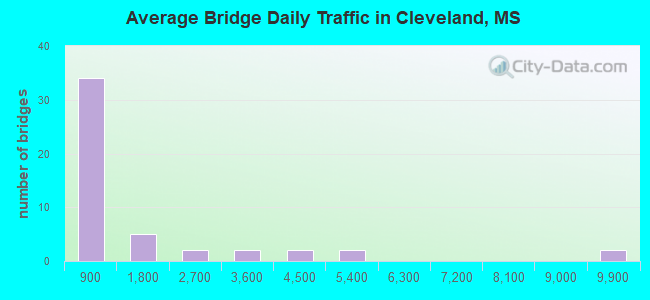
- 60,790Total average daily traffic
- 5,081Total average daily truck traffic
- 78,635Total future (year 2033) average daily traffic
- National Bridge Inventory (NBI) Registered Bridges for Cleveland
- No street view available for this location
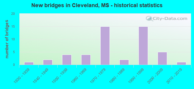
- New bridges - historical statistics
- 11930-1939
- 21940-1949
- 41950-1959
- 41960-1969
- 151970-1979
- 21980-1989
- 151990-1999
- 52000-2009
- 12010-2019
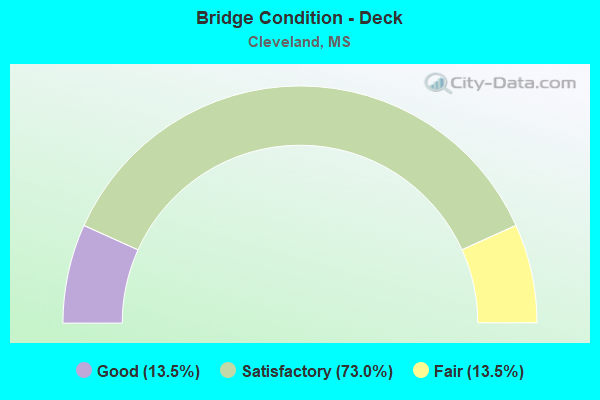
- Bridge Condition - Deck
- 13.5%Good
- 73.0%Satisfactory
- 13.5%Fair
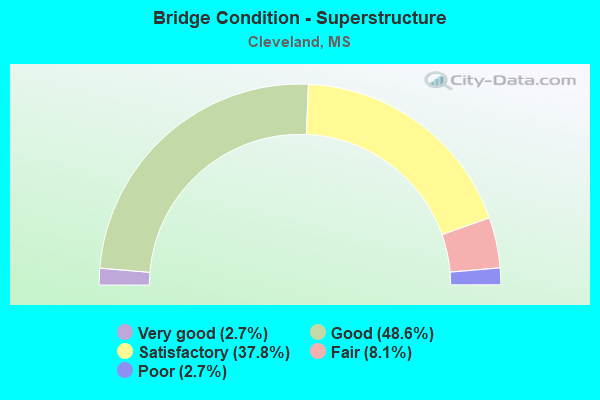
- Bridge Condition - Superstructure
- 2.7%Very good
- 48.6%Good
- 37.8%Satisfactory
- 8.1%Fair
- 2.7%Poor
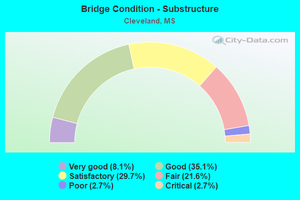
- Bridge Condition - Substructure
- 8.1%Very good
- 35.1%Good
- 29.7%Satisfactory
- 21.6%Fair
- 2.7%Poor
- 2.7%Critical
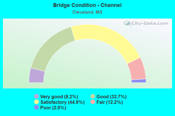
- Bridge Condition - Channel
- 8.2%Very good
- 32.7%Good
- 44.9%Satisfactory
- 12.2%Fair
- 2.0%Poor
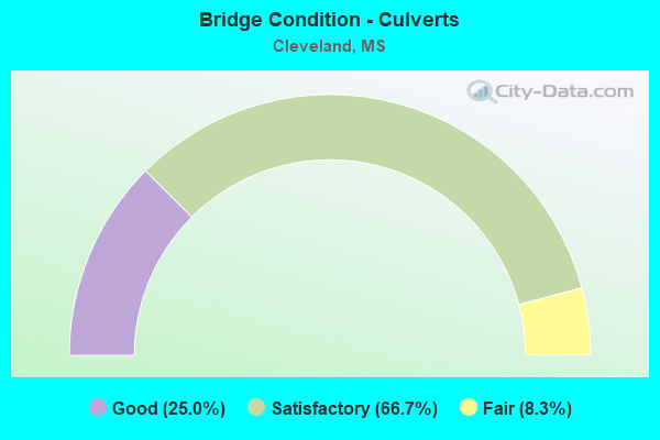
- Bridge Condition - Culverts
- 25.0%Good
- 66.7%Satisfactory
- 8.3%Fair
Find on map >> Show street view
Structure Number: SA0600000000122, Location: SEC 27 T22N R 6W (Lat: 33.718444, Lng: -90.802000), Route carried "on" structure: County highway 345, Year Built: 1996, Status: Posted for load, Structure Length: 1.52m (4.99ft), Average Daily Traffic: 60 (year 2014), Average Future Daily Traffic: 90 (year 2034), Design Load: HS 20, Features Intersected: ICY BOGUE CK, Facility Carried by Structure: LAUGHLIN ROAD
Minimum Vertical Clearance: 30+ m (98+ ft), Kilometerpoint: 6.920, Lanes on structure: 2, Owner: County Highway Agency, Approaching Roadway Width: 6.1m (20.0ft), Material/Design: Steel, Design/Construction: Stringer/Multi-beam, Number Of Spans In Main Unit: 1, Length of Maximum Span: 15.2m (49.9ft), Curb-To-Curb Width: 7.4m (24.3ft), Out-to-Out Width: 7.4m (24.3ft)
Condition: Deck: Good, Superstructure: Good, Substructure: Good, Channel: Good, Operating Rating: 33.4 metric tons, Method Used To Determine Operating Rating: Load Factor (LF) rating reported by rating factor (RF) method using MS18 loading, Inventory Rating: 19.8 metric tons, Method Used To Determine Inventory Rating: Load Factor (LF) rating reported by rating factor (RF) method using MS18 loading, Structural Evaluation: Somewhat better than minimum adequacy, Deck Geometry: Equal to present minimum criteria, Waterway Adequacy: Equal to present desirable criteria, Approach Roadway Alignment: Equal to present desirable criteria, Bridge Posting: Required (Relationship of Operating Rating to Maximum Legal Load: 0.1 - 9.9% below), Length Of Structure Improvement: 2.00m (6.56ft), Designated Inspection Frequency: Every 24 months, Inspection Date: January 2020, Bridge Improvement Cost: $110,000, Roadway Improvement Cost: $15,000, Total Project Cost: $125,000 ( Estimate for 2019), Deck Structure Type: Other, Wearing Surface/Protective System: Wearing Surface: Bituminous
Find on map >> Show street view
Structure Number: SA060000000016, Location: SEC 26 T23N R 6W (Lat: 33.806656, Lng: -90.791322), Route carried "on" structure: County highway 290, Year Built: 2000, Status: Open, Structure Length: 4.72m (15.49ft), Average Daily Traffic: 60 (year 2018), Truck Traffic: 10%, Average Future Daily Traffic: 90 (year 2038), Design Load: HS 20, Features Intersected: SNAKE CREEK, Facility Carried by Structure: MCWIMUS ROAD
Minimum Vertical Clearance: 30+ m (98+ ft), Kilometerpoint: 5.310, Lanes on structure: 2, Owner: County Highway Agency, Approaching Roadway Width: 7.0m (23.0ft), Material/Design: Concrete, Design/Construction: Channel Beam, Number Of Spans In Main Unit: 5, Length of Maximum Span: 9.4m (30.8ft), Curb or Sidewalk Widths: Left: 0.4m (1.3ft), Right: 0.4m (1.3ft), Curb-To-Curb Width: 8.5m (27.9ft), Out-to-Out Width: 9.4m (30.8ft)
Condition: Deck: Good, Superstructure: Very good, Substructure: Very good, Channel: Good, Operating Rating: 63.1 metric tons, Method Used To Determine Operating Rating: Load Factor (LF), Inventory Rating: 37.9 metric tons, Method Used To Determine Inventory Rating: Load Factor (LF), Structural Evaluation: Equal to present desirable criteria, Deck Geometry: Better than present minimum criteria, Waterway Adequacy: Equal to present desirable criteria, Approach Roadway Alignment: Equal to present desirable criteria, Designated Inspection Frequency: Every 24 months, Inspection Date: March 2020, Deck Structure Type: Concrete Precast Panels, Wearing Surface/Protective System: Wearing Surface: Monolithic Concrete
Find on map >> Show street view
Structure Number: SA0600000000161, Location: SEC 26 T23N R 6W (Lat: 33.806389, Lng: -90.783889), Route carried "on" structure: County highway 290, Year Built: 1976, Status: Posted for load, Structure Length: 1.16m (3.81ft), Average Daily Traffic: 60 (year 2014), Average Future Daily Traffic: 90 (year 2034), Design Load: HS 20, Features Intersected: WEST BOGUE HASTY CK, Facility Carried by Structure: MCWIMUS ROAD
Minimum Vertical Clearance: 30+ m (98+ ft), Kilometerpoint: 5.954, Lanes on structure: 2, Owner: County Highway Agency, Approaching Roadway Width: 6.1m (20.0ft), Material/Design: Concrete, Design/Construction: Channel Beam, Number Of Spans In Main Unit: 2, Length of Maximum Span: 5.8m (19.0ft), Curb or Sidewalk Widths: Left: 0.2m (0.7ft), Right: 0.2m (0.7ft), Curb-To-Curb Width: 8.1m (26.6ft), Out-to-Out Width: 8.5m (27.9ft)
Condition: Deck: Satisfactory, Superstructure: Satisfactory, Substructure: Satisfactory, Channel: Fair, Operating Rating: 20.7 metric tons, Method Used To Determine Operating Rating: Load Factor (LF) rating reported by rating factor (RF) method using MS18 loading, Inventory Rating: 12.6 metric tons, Method Used To Determine Inventory Rating: Load Factor (LF) rating reported by rating factor (RF) method using MS18 loading, Structural Evaluation: Meets minimum limits, Deck Geometry: Equal to present minimum criteria, Waterway Adequacy: Equal to present desirable criteria, Approach Roadway Alignment: Equal to present desirable criteria, Bridge Posting: Required (Relationship of Operating Rating to Maximum Legal Load: 0.1 - 9.9% below), Length Of Structure Improvement: 2.10m (6.89ft), Designated Inspection Frequency: Every 24 months, Inspection Date: November 2021, Bridge Improvement Cost: $125,000, Roadway Improvement Cost: $15,000, Total Project Cost: $156,000 ( Estimate for 2015), Deck Structure Type: Concrete Precast Panels
Find on map >> Show street view
Structure Number: SA0600000000166, Location: SEC 35 T23N R 6W B (Lat: 33.792075, Lng: -90.786383), Route carried "on" structure: County highway 1612, Year Built: 1974, Year Reconstructed: 2020, Status: Open, Structure Length: 1.74m (5.71ft), Average Daily Traffic: 110 (year 2015), Truck Traffic: 8%, Average Future Daily Traffic: 165 (year 2038), Design Load: H 15, Features Intersected: WEST BOGUE HASTY CREEK, Facility Carried by Structure: TOWNSHIP ROAD
Minimum Vertical Clearance: 30+ m (98+ ft), Kilometerpoint: 6.276, Lanes on structure: 2, Owner: County Highway Agency, Approaching Roadway Width: 7.1m (23.3ft), Material/Design: Concrete, Design/Construction: Channel Beam, Number Of Spans In Main Unit: 3, Length of Maximum Span: 5.8m (19.0ft), Curb or Sidewalk Widths: Left: 0.2m (0.7ft), Right: 0.2m (0.7ft), Curb-To-Curb Width: 8.1m (26.6ft), Out-to-Out Width: 8.5m (27.9ft)
Condition: Deck: Satisfactory, Superstructure: Good, Substructure: Very good, Channel: Good, Operating Rating: 58.8 metric tons, Method Used To Determine Operating Rating: Load Factor (LF), Inventory Rating: 35.3 metric tons, Method Used To Determine Inventory Rating: Load Factor (LF), Structural Evaluation: Better than present minimum criteria, Deck Geometry: Somewhat better than minimum adequacy, Waterway Adequacy: Equal to present desirable criteria, Approach Roadway Alignment: Equal to present desirable criteria, Length Of Structure Improvement: 2.83m (9.28ft), Designated Inspection Frequency: Every 24 months, Inspection Date: July 2020, Bridge Improvement Cost: $169,000, Roadway Improvement Cost: $17,000, Total Project Cost: $208,000 ( Estimate for 2020), Deck Structure Type: Concrete Precast Panels, Wearing Surface/Protective System: Wearing Surface: Monolithic Concrete
Find on map >> Show street view
Structure Number: SA0600000000167, Location: SEC 36 T23N R 6W B (Lat: 33.792222, Lng: -90.774444), Route carried "on" structure: County highway 1612, Year Built: 1974, Status: Posted for load, Structure Length: 1.16m (3.81ft), Average Daily Traffic: 110 (year 2015), Truck Traffic: 8%, Average Future Daily Traffic: 165 (year 2035), Design Load: HS 20, Features Intersected: ICE BAYOU, Facility Carried by Structure: TOWNSHIP ROAD
Minimum Vertical Clearance: 30+ m (98+ ft), Kilometerpoint: 7.402, Lanes on structure: 2, Owner: County Highway Agency, Approaching Roadway Width: 6.1m (20.0ft), Material/Design: Concrete, Design/Construction: Channel Beam, Number Of Spans In Main Unit: 2, Length of Maximum Span: 5.8m (19.0ft), Curb or Sidewalk Widths: Left: 0.2m (0.7ft), Right: 0.2m (0.7ft), Curb-To-Curb Width: 8.1m (26.6ft), Out-to-Out Width: 8.5m (27.9ft)
Condition: Deck: Satisfactory, Superstructure: Satisfactory, Substructure: Fair, Channel: Fair, Operating Rating: 36.8 metric tons, Method Used To Determine Operating Rating: Load Factor (LF), Inventory Rating: 22.1 metric tons, Method Used To Determine Inventory Rating: Load Factor (LF), Structural Evaluation: Somewhat better than minimum adequacy, Deck Geometry: Somewhat better than minimum adequacy, Waterway Adequacy: Equal to present desirable criteria, Approach Roadway Alignment: Equal to present desirable criteria, Length Of Structure Improvement: 2.10m (6.89ft), Designated Inspection Frequency: Every 12 months, Inspection Date: November 2021, Bridge Improvement Cost: $125,000, Roadway Improvement Cost: $15,000, Total Project Cost: $156,000 ( Estimate for 2016), Deck Structure Type: Concrete Precast Panels
Find on map >> Show street view
Structure Number: SA0600000000246, Location: SEC 15 T22N R 5W (Lat: 33.751111, Lng: -90.706667), Route carried "on" structure: County highway 1510, Year Built: 2003, Status: Open, Structure Length: 2.32m (7.61ft), Average Daily Traffic: 300 (year 2018), Truck Traffic: 8%, Average Future Daily Traffic: 450 (year 2038), Design Load: H 15, Features Intersected: LEAD BAYOU, Facility Carried by Structure: THIRD STREET
Minimum Vertical Clearance: 30+ m (98+ ft), Kilometerpoint: 0.966, Lanes on structure: 2, Owner: County Highway Agency, Approaching Roadway Width: 10.7m (35.1ft), Material/Design: Concrete, Design/Construction: Channel Beam, Number Of Spans In Main Unit: 4, Length of Maximum Span: 5.8m (19.0ft), Curb or Sidewalk Widths: Left: 0.2m (0.7ft), Right: 0.2m (0.7ft), Curb-To-Curb Width: 11.3m (37.1ft), Out-to-Out Width: 11.8m (38.7ft)
Condition: Deck: Satisfactory, Superstructure: Good, Substructure: Satisfactory, Channel: Satisfactory, Operating Rating: 60.1 metric tons, Method Used To Determine Operating Rating: Load Factor (LF), Inventory Rating: 36.0 metric tons, Method Used To Determine Inventory Rating: Load Factor (LF), Structural Evaluation: Equal to present minimum criteria, Deck Geometry: Superior to present desirable criteria, Waterway Adequacy: Equal to present desirable criteria, Approach Roadway Alignment: Equal to present desirable criteria, Length Of Structure Improvement: 2.83m (9.28ft), Designated Inspection Frequency: Every 24 months, Inspection Date: March 2020, Bridge Improvement Cost: $169,000, Roadway Improvement Cost: $17,000, Total Project Cost: $208,000 ( Estimate for 2019), Deck Structure Type: Concrete Precast Panels, Wearing Surface/Protective System: Wearing Surface: Monolithic Concrete
Find on map >> Show street view
Structure Number: SA0600000000249, Location: SEC 25 T22N R 5W (Lat: 33.723278, Lng: -90.665139), Route carried "on" structure: County highway , Year Built: 1975, Status: Open, Structure Length: 1.16m (3.81ft), Average Daily Traffic: 200 (year 2020), Truck Traffic: 8%, Average Future Daily Traffic: 300 (year 2040), Design Load: H 15, Features Intersected: TRIB OF LEAD CREEK, Facility Carried by Structure: OLD RULEVILLE ROAD
Minimum Vertical Clearance: 30+ m (98+ ft), Kilometerpoint: 0.580, Lanes on structure: 2, Owner: County Highway Agency, Approaching Roadway Width: 6.1m (20.0ft), Material/Design: Concrete, Design/Construction: Channel Beam, Number Of Spans In Main Unit: 2, Length of Maximum Span: 5.8m (19.0ft), Curb or Sidewalk Widths: Left: 0.2m (0.7ft), Right: 0.2m (0.7ft), Curb-To-Curb Width: 8.1m (26.6ft), Out-to-Out Width: 8.5m (27.9ft)
Condition: Deck: Satisfactory, Superstructure: Satisfactory, Substructure: Satisfactory, Channel: Satisfactory, Operating Rating: 58.8 metric tons, Method Used To Determine Operating Rating: Load Factor (LF), Inventory Rating: 35.3 metric tons, Method Used To Determine Inventory Rating: Load Factor (LF), Structural Evaluation: Equal to present minimum criteria, Deck Geometry: Somewhat better than minimum adequacy, Waterway Adequacy: Better than present minimum criteria, Approach Roadway Alignment: Equal to present desirable criteria, Length Of Structure Improvement: 1.74m (5.71ft), Designated Inspection Frequency: Every 24 months, Inspection Date: March 2021, Bridge Improvement Cost: $103,000, Roadway Improvement Cost: $10,000, Total Project Cost: $127,000 ( Estimate for 2020), Deck Structure Type: Concrete Precast Panels, Wearing Surface/Protective System: Wearing Surface: Monolithic Concrete
Find on map >> Show street view
Structure Number: SA060000000A094, Location: SEC 26 T22N R 5W (Lat: 33.718486, Lng: -90.680108), Route carried "on" structure: County highway 337, Year Built: 2019, Status: Open, Structure Length: 1.74m (5.71ft), Average Daily Traffic: 150 (year 2021), Truck Traffic: 8%, Average Future Daily Traffic: 225 (year 2041), Design Load: H 15, Features Intersected: OTTER LAKE, Facility Carried by Structure: SUNRISE DRIVE
Minimum Vertical Clearance: 30+ m (98+ ft), Kilometerpoint: 1.609, Lanes on structure: 2, Owner: County Highway Agency, Approaching Roadway Width: 6.7m (22.0ft), Material/Design: Concrete, Design/Construction: Channel Beam, Number Of Spans In Main Unit: 3, Length of Maximum Span: 5.8m (19.0ft), Curb or Sidewalk Widths: Left: 0.2m (0.7ft), Right: 0.2m (0.7ft), Curb-To-Curb Width: 7.1m (23.3ft), Out-to-Out Width: 7.5m (24.6ft)
Condition: Deck: Satisfactory, Superstructure: Satisfactory, Substructure: Satisfactory, Channel: Very good, Operating Rating: 59.5 metric tons, Method Used To Determine Operating Rating: Load Factor (LF), Inventory Rating: 35.6 metric tons, Method Used To Determine Inventory Rating: Load Factor (LF), Structural Evaluation: Equal to present minimum criteria, Deck Geometry: Meets minimum limits, Waterway Adequacy: Equal to present desirable criteria, Approach Roadway Alignment: Equal to present desirable criteria, Length Of Structure Improvement: 2.10m (6.89ft), Designated Inspection Frequency: Every 24 months, Inspection Date: October 2021, Bridge Improvement Cost: $126,000, Roadway Improvement Cost: $13,000, Total Project Cost: $156,000 ( Estimate for 2020), Deck Structure Type: Concrete Precast Panels, Wearing Surface/Protective System: Wearing Surface: Monolithic Concrete
Find on map >> Show street view
Structure Number: SA6700000000128, Location: SEC 19 T22N R 4W (Lat: 33.759347, Lng: -90.658853), Route carried "on" structure: County highway 330, Year Built: 1975, Status: Posted for load, Structure Length: 2.32m (7.61ft), Average Daily Traffic: 50 (year 2013), Truck Traffic: 8%, Average Future Daily Traffic: 75 (year 2033), Design Load: H 15, Features Intersected: NATURAL SLOUGH, Facility Carried by Structure: NORTH BOLIVAR COUN
Minimum Vertical Clearance: 30+ m (98+ ft), Kilometerpoint: 4.345, Lanes on structure: 2, Owner: County Highway Agency, Approaching Roadway Width: 7.3m (24.0ft), Material/Design: Concrete, Design/Construction: Channel Beam, Number Of Spans In Main Unit: 1, Number Of Approach Spans: 3, Length of Maximum Span: 5.8m (19.0ft), Curb or Sidewalk Widths: Left: 0.2m (0.7ft), Right: 0.2m (0.7ft), Curb-To-Curb Width: 8.5m (27.9ft), Out-to-Out Width: 8.9m (29.2ft)
Condition: Deck: Satisfactory, Superstructure: Satisfactory, Substructure: Fair, Channel: Poor, Operating Rating: 9.9 metric tons, Method Used To Determine Operating Rating: Allowable Stress (AS), Inventory Rating: 2.7 metric tons, Method Used To Determine Inventory Rating: Allowable Stress (AS), Structural Evaluation: High priority of replacement, Deck Geometry: Better than present minimum criteria, Waterway Adequacy: Equal to present minimum criteria, Approach Roadway Alignment: Equal to present desirable criteria, Bridge Posting: Required (Relationship of Operating Rating to Maximum Legal Load: > 39.9% below), Length Of Structure Improvement: 3.54m (11.61ft), Designated Inspection Frequency: Every 12 months, Inspection Date: December 2021, Bridge Improvement Cost: $406,000, Roadway Improvement Cost: $100,000, Total Project Cost: $506,000, Deck Structure Type: Concrete Precast Panels, Wearing Surface/Protective System: Wearing Surface: Monolithic Concrete