Bridge Statistics for Clinton, Illinois (IL)
Condition, Traffic, Stress, Structural Evaluation, Project Costs
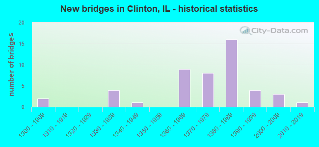
- New bridges - historical statistics
- 21900-1909
- 41930-1939
- 11940-1949
- 91960-1969
- 81970-1979
- 161980-1989
- 41990-1999
- 32000-2009
- 12010-2019
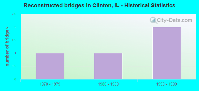
- Reconstructed bridges - Historical Statistics
- 11970-1979
- 11980-1989
- 21990-1999
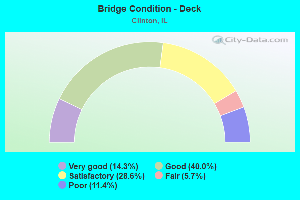
- Bridge Condition - Deck
- 14.3%Very good
- 40.0%Good
- 28.6%Satisfactory
- 5.7%Fair
- 11.4%Poor
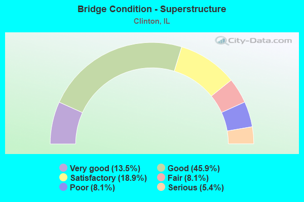
- Bridge Condition - Superstructure
- 13.5%Very good
- 45.9%Good
- 18.9%Satisfactory
- 8.1%Fair
- 8.1%Poor
- 5.4%Serious
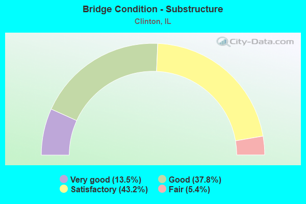
- Bridge Condition - Substructure
- 13.5%Very good
- 37.8%Good
- 43.2%Satisfactory
- 5.4%Fair
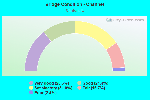
- Bridge Condition - Channel
- 28.6%Very good
- 21.4%Good
- 31.0%Satisfactory
- 16.7%Fair
- 2.4%Poor
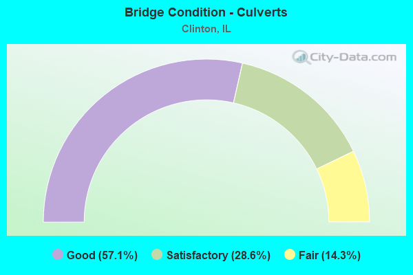
- Bridge Condition - Culverts
- 57.1%Good
- 28.6%Satisfactory
- 14.3%Fair
Find on map >> Show street view
Structure Number: 206, Location: CITY OF CLINTON (Lat: 40.148361, Lng: -88.952292), Route carried "on" structure: Other road , Year Built: 1930, Status: Open, Structure Length: 0.98m (3.22ft), Average Daily Traffic: 800 (year 2018), Truck Traffic: 13%, Average Future Daily Traffic: 1,050 (year 2032), Features Intersected: COON CREEK, Facility Carried by Structure: ALEXANDER (FAU 733
Minimum Vertical Clearance: 30+ m (98+ ft), Kilometerpoint: 0.917, Lanes on structure: 2, Owner: City or Municipal Highway Agency, Approaching Roadway Width: 8.5m (27.9ft), Material/Design: Concrete, Design/Construction: Culvert, Number Of Spans In Main Unit: 4, Length of Maximum Span: 2.1m (6.9ft), Curb-To-Curb Width: 9.1m (29.9ft), Out-to-Out Width: 10.1m (33.1ft)
Condition: Channel: Poor, Culverts: Satisfactory, Operating Rating: 32.4 metric tons, Method Used To Determine Operating Rating: Field evaluation and documented engineering judgment, Inventory Rating: 17.5 metric tons, Method Used To Determine Inventory Rating: Field evaluation and documented engineering judgment, Structural Evaluation: Meets minimum limits, Deck Geometry: Equal to present minimum criteria, Waterway Adequacy: Meets minimum limits, Approach Roadway Alignment: Equal to present desirable criteria, Designated Inspection Frequency: Every 24 months, Inspection Date: March 2021, Wearing Surface/Protective System: Wearing Surface: Gravel
Find on map >> Show street view
Structure Number: 206001, Location: CITY OF CLINTON (Lat: 40.160069, Lng: -88.965503), Route carried "on" structure: Other road , Year Built: 1963, Status: Open, Structure Length: 2.07m (6.79ft), Average Daily Traffic: 175 (year 2018), Truck Traffic: 17%, Average Future Daily Traffic: 200 (year 2032), Design Load: H 15, Features Intersected: TEN MILE CREEK, Facility Carried by Structure: WOODLAWN ST(FAU 73
Minimum Vertical Clearance: 30+ m (98+ ft), Kilometerpoint: 0.418, Lanes on structure: 2, Owner: City or Municipal Highway Agency, Approaching Roadway Width: 9.1m (29.9ft), Skew: 3 degrees, Material/Design: Prestressed concrete, Design/Construction: Box Beam or Girders - Multiple, Number Of Spans In Main Unit: 2, Length of Maximum Span: 10.1m (33.1ft), Curb or Sidewalk Widths: Left: 1.4m (4.6ft), Right: 0.0m, Curb-To-Curb Width: 7.3m (24.0ft), Out-to-Out Width: 9.6m (31.5ft)
Condition: Deck: Satisfactory, Superstructure: Satisfactory, Substructure: Satisfactory, Channel: Fair, Operating Rating: 53.8 metric tons, Method Used To Determine Operating Rating: Load Factor (LF) rating reported by rating factor (RF) method using MS18 loading, Inventory Rating: 32.4 metric tons, Method Used To Determine Inventory Rating: Load Factor (LF) rating reported by rating factor (RF) method using MS18 loading, Structural Evaluation: Equal to present minimum criteria, Deck Geometry: Somewhat better than minimum adequacy, Waterway Adequacy: Better than present minimum criteria, Approach Roadway Alignment: Equal to present minimum criteria, Designated Inspection Frequency: Every 24 months, Inspection Date: December 2020, Deck Structure Type: Concrete Precast Panels, Wearing Surface/Protective System: Membrane: Epoxy
Find on map >> Show street view
Structure Number: 206007, Location: CITY OF CLINTON (Lat: 40.146622, Lng: -88.957931), Route carried "on" structure: Other road , Year Built: 2000, Status: Open, Structure Length: 2.56m (8.40ft), Average Daily Traffic: 1,100 (year 2018), Truck Traffic: 6%, Average Future Daily Traffic: 1,400 (year 2032), Design Load: HS 20, Features Intersected: COON CREEK, Facility Carried by Structure: FAU 7337(MADISON S
Minimum Vertical Clearance: 30+ m (98+ ft), Kilometerpoint: 1.481, Lanes on structure: 2, Owner: City or Municipal Highway Agency, Approaching Roadway Width: 7.3m (24.0ft), Skew: 3 degrees, Material/Design: Prestressed concrete, Design/Construction: Box Beam or Girders - Multiple, Number Of Spans In Main Unit: 3, Length of Maximum Span: 25.1m (82.3ft), Curb-To-Curb Width: 9.1m (29.9ft), Out-to-Out Width: 9.1m (29.9ft)
Condition: Deck: Very good, Superstructure: Very good, Substructure: Very good, Channel: Very good, Operating Rating: 44.1 metric tons, Method Used To Determine Operating Rating: Assigned rating based on Load Factor Design (LFD) reported by rating factor (RF) using MS18 loading, Inventory Rating: 32.4 metric tons, Method Used To Determine Inventory Rating: Assigned rating based on Load Factor Design (LFD) reported by rating factor (RF) using MS18 loading, Structural Evaluation: Equal to present desirable criteria, Deck Geometry: Somewhat better than minimum adequacy, Waterway Adequacy: Superior to present desirable criteria, Approach Roadway Alignment: Better than present minimum criteria, Designated Inspection Frequency: Every 48 months, Inspection Date: January 2020, Deck Structure Type: Concrete Precast Panels, Wearing Surface/Protective System: Wearing Surface: Bituminous, Membrane: Built-up
Find on map >> Show street view
Structure Number: 1020001, Location: 1.26 MI E OF ILL 117 (Lat: 40.614989, Lng: -89.253300), Route carried "on" structure: Interstate 74, Year Built: 1964, Year Reconstructed: 1998, Status: Open, Structure Length: 12.86m (42.19ft), Average Daily Traffic: 13,450 (year 2021), Truck Traffic: 19%, Average Future Daily Traffic: 14,397 (year 2032), Design Load: HS 20+Mod, Features Intersected: MACKINAW RIVER
Minimum Vertical Clearance: 30+ m (98+ ft), Kilometerpoint: 185.391, Lanes on structure: 2, Base Highway Network: Yes, Owner: State Highway Agency, Approaching Roadway Width: 11.6m (38.1ft), Skew: 1 degrees, Material/Design: Steel continuous, Design/Construction: Stringer/Multi-beam, Number Of Spans In Main Unit: 4, Length of Maximum Span: 35.7m (117.1ft), Curb-To-Curb Width: 11.6m (38.1ft), Out-to-Out Width: 12.6m (41.3ft)
Condition: Deck: Satisfactory, Superstructure: Serious, Substructure: Satisfactory, Channel: Fair, Operating Rating: 63.5 metric tons, Method Used To Determine Operating Rating: Load Factor (LF) rating reported by rating factor (RF) method using MS18 loading, Inventory Rating: 37.9 metric tons, Method Used To Determine Inventory Rating: Load Factor (LF) rating reported by rating factor (RF) method using MS18 loading, Structural Evaluation: High priority of corrective action, Deck Geometry: Equal to present minimum criteria, Waterway Adequacy: Superior to present desirable criteria, Approach Roadway Alignment: Equal to present desirable criteria, Designated Inspection Frequency: Every 12 months, Underwater Inspection Frequency: Every 12 months, Other Special Inspection Frequency: Every 6 months, Inspection Date: August 2021, Underwater Inspection Date: August 2021, Other Special Inspection Date: August 2021, Deck Structure Type: Concrete Cast-file-Place, Wearing Surface/Protective System: Deck Protection: Epoxy Coated Reinforcing
Find on map >> Show street view
Structure Number: 209901, Location: IN CLINTON (Lat: 40.154439, Lng: -88.964131), Route carried "under" structure: Business US 51, Year Built: 1939, Structure Length: 0. m, Average Daily Traffic: 4,750 (year 2021), Truck Traffic: 5%, Features Intersected: US 51(FAP 708), Facility Carried by Structure: IC RR
Minimum Vertical Clearance: 4.24m (13.91ft), Kilometerpoint: 2.977, Lanes under structure: 2, Material/Design: Steel, Design/Construction: Girder and Floorbeam System, Length of Maximum Span: 13.4m (44.0ft)
Find on map >> Show street view
Structure Number: 209902, Location: W OF CLINTON (Lat: 40.150406, Lng: -88.975847), Route carried "under" structure: State highway 10, Year Built: 1940, Structure Length: 0. m, Average Daily Traffic: 2,250 (year 2021), Truck Traffic: 9%, Features Intersected: IL 10(FAP 717), Facility Carried by Structure: IC RR
Minimum Vertical Clearance: 4.57m (14.99ft), Kilometerpoint: 84.199, Lanes under structure: 2, Material/Design: Steel, Design/Construction: Girder and Floorbeam System, Length of Maximum Span: 13.7m (44.9ft)
Find on map >> Show street view
Structure Number: 209903, Location: IN CLINTON (Lat: 40.148258, Lng: -88.955794), Route carried "under" structure: State highway 10, Year Built: 1933, Structure Length: 0. m, Average Daily Traffic: 7,850 (year 2021), Truck Traffic: 8%, Features Intersected: IL 10/US 54(FAP 71), Facility Carried by Structure: IC RR
Minimum Vertical Clearance: 4.39m (14.40ft), Kilometerpoint: 85.760, Lanes under structure: 2, Material/Design: Steel, Design/Construction: Girder and Floorbeam System, Length of Maximum Span: 11.0m (36.1ft)
Find on map >> Show street view
Structure Number: 209904, Location: WOODLAWN E OF LINCOL (Lat: 40.159956, Lng: -88.956383), Route carried "under" structure: Other road , Year Built: 1900, Structure Length: 0. m, Average Daily Traffic: 1,200 (year 2018), Truck Traffic: 6%, Features Intersected: FAU 7307, Facility Carried by Structure: IC RR
Minimum Vertical Clearance: 3.56m (11.68ft), Kilometerpoint: 0.354, Lanes under structure: 2, Material/Design: Concrete, Length of Maximum Span: 4.9m (16.1ft)