Bridge Statistics for Clinton, Iowa (IA)
Condition, Traffic, Stress, Structural Evaluation, Project Costs
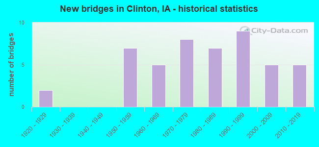
- New bridges - historical statistics
- 21920-1929
- 71950-1959
- 51960-1969
- 81970-1979
- 71980-1989
- 91990-1999
- 52000-2009
- 52010-2019
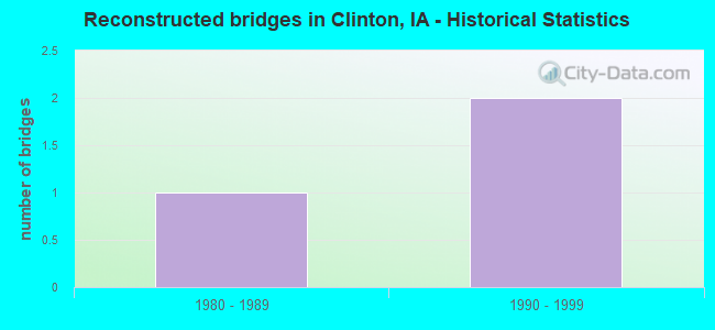
- Reconstructed bridges - Historical Statistics
- 11980-1989
- 21990-1999
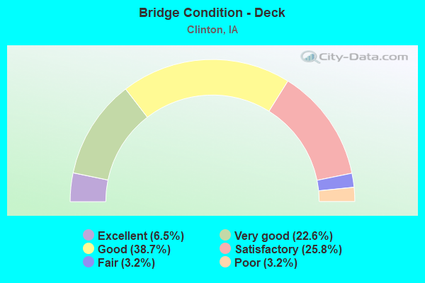
- Bridge Condition - Deck
- 6.5%Excellent
- 22.6%Very good
- 38.7%Good
- 25.8%Satisfactory
- 3.2%Fair
- 3.2%Poor
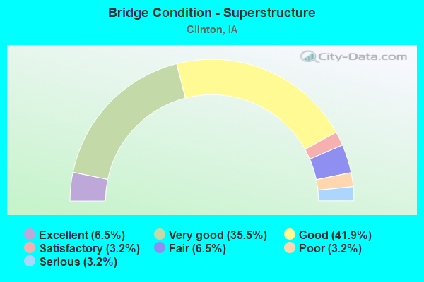
- Bridge Condition - Superstructure
- 6.5%Excellent
- 35.5%Very good
- 41.9%Good
- 3.2%Satisfactory
- 6.5%Fair
- 3.2%Poor
- 3.2%Serious
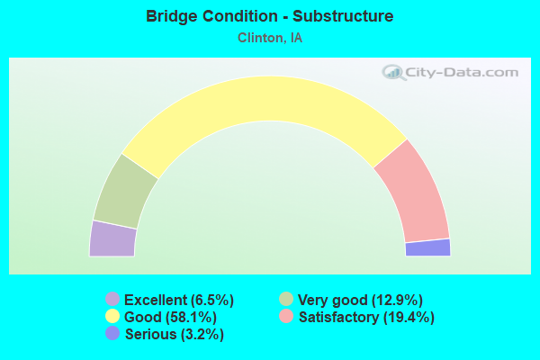
- Bridge Condition - Substructure
- 6.5%Excellent
- 12.9%Very good
- 58.1%Good
- 19.4%Satisfactory
- 3.2%Serious
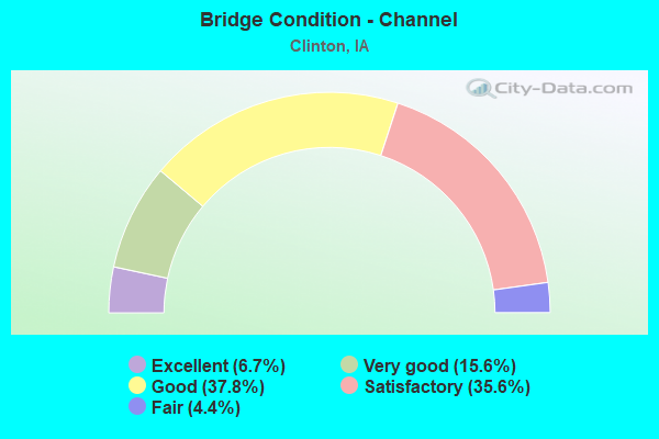
- Bridge Condition - Channel
- 6.7%Excellent
- 15.6%Very good
- 37.8%Good
- 35.6%Satisfactory
- 4.4%Fair
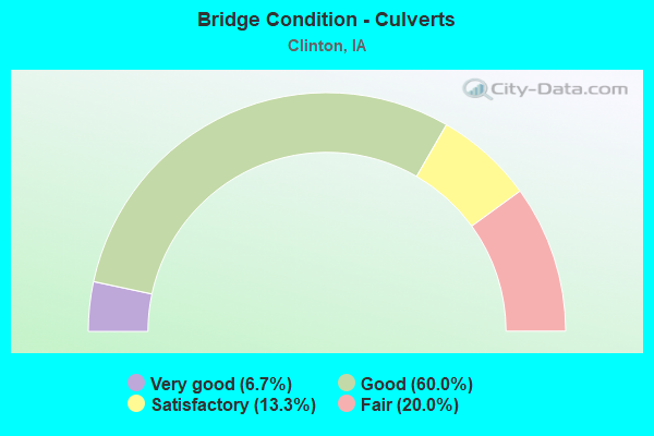
- Bridge Condition - Culverts
- 6.7%Very good
- 60.0%Good
- 13.3%Satisfactory
- 20.0%Fair
Find on map >> Show street view
Structure Number: 504535, Location: 081061505 (Lat: 41.824728, Lng: -90.255411), Route carried "on" structure: City street , Year Built: 2000, Status: Open, Structure Length: 4.66m (15.29ft), Average Daily Traffic: 8,700 (year 2018), Average Future Daily Traffic: 8,700 (year 2040), Design Load: HS 20, Features Intersected: HARTS MILL CREEK, Facility Carried by Structure: MILL CR. EXPWY.
Minimum Vertical Clearance: 30+ m (98+ ft), Kilometerpoint: 2.203, Lanes on structure: 2, Owner: City or Municipal Highway Agency, Approaching Roadway Width: 13.4m (44.0ft), Skew: 1 degrees, Material/Design: Concrete continuous, Design/Construction: Slab, Number Of Spans In Main Unit: 3, Length of Maximum Span: 18.0m (59.1ft), Curb-To-Curb Width: 12.2m (40.0ft), Out-to-Out Width: 13.2m (43.3ft)
Condition: Deck: Satisfactory, Superstructure: Satisfactory, Substructure: Good, Channel: Very good, Operating Rating: 55.6 metric tons, Method Used To Determine Operating Rating: Load Factor (LF), Inventory Rating: 33.3 metric tons, Method Used To Determine Inventory Rating: Load Factor (LF), Structural Evaluation: Equal to present minimum criteria, Deck Geometry: Somewhat better than minimum adequacy, Waterway Adequacy: Equal to present desirable criteria, Approach Roadway Alignment: Equal to present desirable criteria, Length Of Structure Improvement: 15.00m (49.21ft), Designated Inspection Frequency: Every 24 months, Inspection Date: May 2020, Bridge Improvement Cost: $15,000, Roadway Improvement Cost: $2,000, Deck Structure Type: Concrete Cast-file-Place, Wearing Surface/Protective System: Wearing Surface: Monolithic Concrete, Deck Protection: Epoxy Coated Reinforcing
Find on map >> Show street view
Structure Number: 50454, Location: 081061107 (Lat: 41.842664, Lng: -90.237375), Route carried "on" structure: City street , Year Built: 2000, Status: Open, Structure Length: 8.02m (26.31ft), Average Daily Traffic: 8,000 (year 2018), Average Future Daily Traffic: 8,000 (year 2040), Design Load: HS 20, Features Intersected: MILL CREEK, Facility Carried by Structure: MILL CR. EXPWY.
Minimum Vertical Clearance: 30+ m (98+ ft), Kilometerpoint: 4.806, Lanes on structure: 2, Owner: City or Municipal Highway Agency, Approaching Roadway Width: 13.4m (44.0ft), Skew: 3 degrees, Material/Design: Prestressed concrete, Design/Construction: Stringer/Multi-beam, Number Of Spans In Main Unit: 3, Length of Maximum Span: 28.0m (91.9ft), Curb-To-Curb Width: 12.2m (40.0ft), Out-to-Out Width: 13.2m (43.3ft)
Condition: Deck: Good, Superstructure: Very good, Substructure: Very good, Channel: Very good, Operating Rating: 65.3 metric tons, Method Used To Determine Operating Rating: Load Factor (LF), Inventory Rating: 39.2 metric tons, Method Used To Determine Inventory Rating: Load Factor (LF), Structural Evaluation: Equal to present desirable criteria, Deck Geometry: Somewhat better than minimum adequacy, Waterway Adequacy: Equal to present desirable criteria, Approach Roadway Alignment: Equal to present desirable criteria, Length Of Structure Improvement: 26.30m (86.29ft), Designated Inspection Frequency: Every 24 months, Inspection Date: May 2020, Bridge Improvement Cost: $15,000, Roadway Improvement Cost: $2,000, Deck Structure Type: Concrete Cast-file-Place, Wearing Surface/Protective System: Wearing Surface: Monolithic Concrete, Deck Protection: Epoxy Coated Reinforcing
Find on map >> Show street view
Structure Number: 505575, Location: 082071902 (Lat: 41.878225, Lng: -90.180586), Route carried "on" structure: City street , Year Built: 2019, Status: Open, Structure Length: 1.26m (4.13ft), Average Daily Traffic: 115 (year 1975), Average Future Daily Traffic: 115 (year 2041), Design Load: HL 93, Features Intersected: TURTLE CREEK, Facility Carried by Structure: 28TH AVE NORTH
Minimum Vertical Clearance: 30+ m (98+ ft), Kilometerpoint: 0.726, Lanes on structure: 2, Owner: City or Municipal Highway Agency, Approaching Roadway Width: 7.9m (25.9ft), Skew: 6 degrees, Material/Design: Concrete continuous, Design/Construction: Culvert, Number Of Spans In Main Unit: 2, Length of Maximum Span: 3.0m (9.8ft), Curb or Sidewalk Widths: Left: 1.5m (4.9ft), Right: 0.0m
Condition: Channel: Very good, Culverts: Good, Operating Rating: 42.1 metric tons, Method Used To Determine Operating Rating: Assigned ratings based on Load and Resistance Factor Design (LRFD) reported by rating factor (RF) using HL93 loadings, Inventory Rating: 32.4 metric tons, Method Used To Determine Inventory Rating: Assigned ratings based on Load and Resistance Factor Design (LRFD) reported by rating factor (RF) using HL93 loadings, Structural Evaluation: Better than present minimum criteria, Waterway Adequacy: Equal to present desirable criteria, Approach Roadway Alignment: Equal to present minimum criteria, Designated Inspection Frequency: Every 24 months, Inspection Date: May 2021
Find on map >> Show street view
Structure Number: 700475, Location: IN CITY OF CLINTON (Lat: 41.873694, Lng: -90.184753), Route carried "on" structure: State highway 136, Year Built: 2016, Status: Open, Structure Length: 0.80m (2.62ft), Average Daily Traffic: 4,420 (year 2020), Truck Traffic: 5%, Average Future Daily Traffic: 4,420 (year 2040), Design Load: HL 93, Features Intersected: CAR BARN CREEK
Minimum Vertical Clearance: 30+ m (98+ ft), Kilometerpoint: 1.917, Lanes on structure: 2, Base Highway Network: Yes, Owner: State Highway Agency, Approaching Roadway Width: 11.0m (36.1ft), Skew: 3 degrees, Material/Design: Concrete continuous, Design/Construction: Culvert, Number Of Spans In Main Unit: 2, Length of Maximum Span: 3.0m (9.8ft)
Condition: Channel: Excellent, Culverts: Very good, Operating Rating: 52.8 metric tons, Method Used To Determine Operating Rating: Load and Resistance Factor Rating (LRFR) rating reported by rating factor(RF) method using HL-93 loadings, Inventory Rating: 40.5 metric tons, Method Used To Determine Inventory Rating: Load and Resistance Factor Rating (LRFR) rating reported by rating factor(RF) method using HL-93 loadings, Structural Evaluation: Equal to present desirable criteria, Waterway Adequacy: Superior to present desirable criteria, Approach Roadway Alignment: Equal to present desirable criteria, Designated Inspection Frequency: Every 24 months, Inspection Date: September 2020
Find on map >> Show street view
Structure Number: 235, Location: 081061306 (Lat: 41.817219, Lng: -90.218186), Route carried "under" structure: City street , Year Built: 1957, Structure Length: 0. m, Average Daily Traffic: 420 (year 1986), Features Intersected: UP RR, Facility Carried by Structure: CO RD-S 14TH
Minimum Vertical Clearance: 30+ m (98+ ft), Kilometerpoint: 1.255, Lanes on structure: 2, Material/Design: Steel continuous, Design/Construction: Stringer/Multi-beam, Length of Maximum Span: 25.6m (84.0ft)
Find on map >> Show street view
Structure Number: 2086, Location: IN CLINTON (Lat: 41.837811, Lng: -90.190483), Route carried "under" structure: City street , Year Built: 1956, Structure Length: 0. m, Average Daily Traffic: 700 (year 2014), Features Intersected: MISSISSIPPI RVR RR S 2ND, Facility Carried by Structure: US 30
Minimum Vertical Clearance: 30+ m (98+ ft), Kilometerpoint: 0.943, Lanes on structure: 2, Material/Design: Steel, Design/Construction: Suspension, Length of Maximum Span: 196.3m (644.0ft)