Bridge Statistics for Cloverdale, Indiana (IN)
Condition, Traffic, Stress, Structural Evaluation, Project Costs
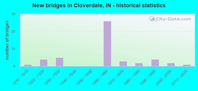
- New bridges - historical statistics
- 11910-1919
- 41920-1929
- 51930-1939
- 261960-1969
- 31970-1979
- 21980-1989
- 41990-1999
- 22000-2009
- 12010-2019

- Reconstructed bridges - Historical Statistics
- 11970-1979
- 11980-1989
- 51990-1999
- 12000-2009
- 52010-2019
- 22020-2022


- Bridge Condition - Deck
- 7.1%Very good
- 42.9%Good
- 21.4%Satisfactory
- 17.9%Fair
- 10.7%Poor

- Bridge Condition - Superstructure
- 13.3%Very good
- 26.7%Good
- 30.0%Satisfactory
- 23.3%Fair
- 6.7%Poor

- Bridge Condition - Substructure
- 10.0%Very good
- 46.7%Good
- 20.0%Satisfactory
- 13.3%Fair
- 6.7%Poor
- 3.3%Serious

- Bridge Condition - Channel
- 25.0%Very good
- 42.9%Good
- 10.7%Satisfactory
- 10.7%Fair
- 7.1%Poor
- 3.6%Serious

- Bridge Condition - Culverts
- 16.7%Very good
- 50.0%Good
- 16.7%Fair
- 16.7%Poor
Find on map >> Show street view
Structure Number: 416, Location: 01.43 E SR 243 (Lat: 39.533131, Lng: -86.851131), Route carried "on" structure: Alternate County highway , Year Built: 1965, Status: Open, Structure Length: 6.86m (22.51ft), Average Daily Traffic: 140 (year 2020), Truck Traffic: 1%, Average Future Daily Traffic: 160 (year 2030), Design Load: HS 20, Features Intersected: I-70 EB/WB, Facility Carried by Structure: POPLAR GROVE ROAD
Minimum Vertical Clearance: 30+ m (98+ ft), Kilometerpoint: 0.000, Lanes on structure: 2, Lanes under structure: 4, Owner: State Highway Agency, Approaching Roadway Width: 6.1m (20.0ft), Material/Design: Concrete continuous, Design/Construction: Stringer/Multi-beam, Number Of Spans In Main Unit: 4, Length of Maximum Span: 21.7m (71.2ft), Curb or Sidewalk Widths: Left: 0.5m (1.6ft), Right: 0.5m (1.6ft), Curb-To-Curb Width: 7.3m (24.0ft), Out-to-Out Width: 9.0m (29.5ft)
Condition: Deck: Good, Superstructure: Satisfactory, Substructure: Good, Operating Rating: 56.5 metric tons, Method Used To Determine Operating Rating: Load Factor (LF), Inventory Rating: 33.8 metric tons, Method Used To Determine Inventory Rating: Load Factor (LF), Structural Evaluation: Equal to present minimum criteria, Deck Geometry: Somewhat better than minimum adequacy, Underclear: Somewhat better than minimum adequacy, Approach Roadway Alignment: Equal to present desirable criteria, Designated Inspection Frequency: Every 24 months, Inspection Date: January 2022, Deck Structure Type: Concrete Cast-file-Place, Wearing Surface/Protective System: Wearing Surface: Epoxy Overlay
Find on map >> Show street view
Structure Number: 1582, Location: 01.03 E SR 243 (Lat: 39.469069, Lng: -86.842000), Route carried "on" structure: State highway 42, Year Built: 1939, Status: Open, Structure Length: 4.51m (14.80ft), Average Daily Traffic: 1,960 (year 2006), Truck Traffic: 5%, Average Future Daily Traffic: 3,253 (year 2030), Design Load: H 20, Features Intersected: DOE CREEK
Minimum Vertical Clearance: 30+ m (98+ ft), Kilometerpoint: 11.040, Lanes on structure: 2, Owner: State Highway Agency, Approaching Roadway Width: 5.5m (18.0ft), Material/Design: Concrete, Design/Construction: Arch - Deck, Number Of Spans In Main Unit: 3, Length of Maximum Span: 21.3m (69.9ft), Curb or Sidewalk Widths: Left: 0.2m (0.7ft), Right: 0.2m (0.7ft), Curb-To-Curb Width: 7.3m (24.0ft), Out-to-Out Width: 8.2m (26.9ft)
Condition: Superstructure: Fair, Substructure: Fair, Channel: Very good, Operating Rating: 54.9 metric tons, Method Used To Determine Operating Rating: Field evaluation and documented engineering judgment, Inventory Rating: 32.7 metric tons, Method Used To Determine Inventory Rating: Field evaluation and documented engineering judgment, Structural Evaluation: Somewhat better than minimum adequacy, Deck Geometry: Meets minimum limits, Waterway Adequacy: High priority of replacement, Approach Roadway Alignment: Equal to present desirable criteria, Length Of Structure Improvement: 4.51m (14.80ft), Designated Inspection Frequency: Every 24 months, Inspection Date: April 2020, Bridge Improvement Cost: $844,000, Total Project Cost: $844,000
Find on map >> Show street view
Structure Number: 15825, Location: 01.10 W US 231 (Lat: 39.491881, Lng: -86.800611), Route carried "on" structure: State highway 42, Year Built: 1993, Status: Open, Structure Length: 0.73m (2.40ft), Average Daily Traffic: 2,306 (year 2004), Truck Traffic: 10%, Average Future Daily Traffic: 3,828 (year 2030), Design Load: HS 20, Features Intersected: BRANCH DOE CREEK
Minimum Vertical Clearance: 30+ m (98+ ft), Kilometerpoint: 5.198, Lanes on structure: 2, Owner: State Highway Agency, Approaching Roadway Width: 11.0m (36.1ft), Skew: 2 degrees, Material/Design: Concrete, Design/Construction: Culvert, Number Of Spans In Main Unit: 2, Length of Maximum Span: 3.4m (11.2ft)
Condition: Channel: Good, Culverts: Good, Operating Rating: 54.5 metric tons, Method Used To Determine Operating Rating: Field evaluation and documented engineering judgment, Inventory Rating: 32.7 metric tons, Method Used To Determine Inventory Rating: Field evaluation and documented engineering judgment, Structural Evaluation: Better than present minimum criteria, Waterway Adequacy: Better than present minimum criteria, Approach Roadway Alignment: Equal to present desirable criteria, Designated Inspection Frequency: Every 24 months, Inspection Date: April 2020
Find on map >> Show street view
Structure Number: 1598, Location: 00.33 N of SR 42 (Lat: 39.504561, Lng: -86.793369), Route carried "on" structure: US 231, Year Built: 1931, Status: Open, Structure Length: 0.82m (2.69ft), Average Daily Traffic: 8,540 (year 2006), Truck Traffic: 5%, Average Future Daily Traffic: 11,829 (year 2033), Design Load: H 20, Features Intersected: DOE CREEK
Minimum Vertical Clearance: 30+ m (98+ ft), Kilometerpoint: 3.879, Lanes on structure: 2, Base Highway Network: Yes (, Subroute: 1), Owner: State Highway Agency, Approaching Roadway Width: 9.1m (29.9ft), Skew: 1 degrees, Material/Design: Concrete, Design/Construction: Arch - Deck, Number Of Spans In Main Unit: 1, Length of Maximum Span: 7.3m (24.0ft), Curb-To-Curb Width: 9.1m (29.9ft), Out-to-Out Width: 9.1m (29.9ft)
Condition: Superstructure: Fair, Substructure: Fair, Channel: Very good, Operating Rating: 76.2 metric tons, Method Used To Determine Operating Rating: Load Factor (LF), Inventory Rating: 45.4 metric tons, Method Used To Determine Inventory Rating: Load Factor (LF), Structural Evaluation: Somewhat better than minimum adequacy, Deck Geometry: High priority of corrective action, Waterway Adequacy: Superior to present desirable criteria, Approach Roadway Alignment: Equal to present minimum criteria, Designated Inspection Frequency: Every 24 months, Inspection Date: April 2021
Find on map >> Show street view
Structure Number: 1599, Location: 01.09 N I-70 (Lat: 39.548150, Lng: -86.807889), Route carried "on" structure: US 231, Year Built: 1966, Year Reconstructed: 2001, Status: Open, Structure Length: 3.17m (10.40ft), Average Daily Traffic: 11,120 (year 2018), Truck Traffic: 16%, Average Future Daily Traffic: 14,819 (year 2028), Design Load: HS 20, Features Intersected: BR LOWER LIMESTONE CREEK
Minimum Vertical Clearance: 30+ m (98+ ft), Kilometerpoint: 9.045, Lanes on structure: 2, Base Highway Network: Yes (, Subroute: 1), Owner: State Highway Agency, Approaching Roadway Width: 13.4m (44.0ft), Skew: 3 degrees, Material/Design: Concrete continuous, Design/Construction: Slab, Number Of Spans In Main Unit: 3, Length of Maximum Span: 12.8m (42.0ft), Curb-To-Curb Width: 13.2m (43.3ft), Out-to-Out Width: 14.1m (46.3ft)
Condition: Deck: Good, Superstructure: Good, Substructure: Good, Channel: Good, Operating Rating: 44.1 metric tons, Method Used To Determine Operating Rating: Load and Resistance Factor Rating (LRFR) rating reported by rating factor(RF) method using HL-93 loadings, Inventory Rating: 34.0 metric tons, Method Used To Determine Inventory Rating: Load and Resistance Factor Rating (LRFR) rating reported by rating factor(RF) method using HL-93 loadings, Structural Evaluation: Better than present minimum criteria, Deck Geometry: Somewhat better than minimum adequacy, Waterway Adequacy: Superior to present desirable criteria, Approach Roadway Alignment: Equal to present desirable criteria, Designated Inspection Frequency: Every 24 months, Inspection Date: April 2021, Deck Structure Type: Concrete Cast-file-Place, Wearing Surface/Protective System: Wearing Surface: Epoxy Overlay, Deck Protection: Epoxy Coated Reinforcing
Find on map >> Show street view
Structure Number: 16, Location: 01.49 N I-70 (Lat: 39.553431, Lng: -86.810819), Route carried "on" structure: US 231, Year Built: 1966, Year Reconstructed: 2001, Status: Open, Structure Length: 2.62m (8.60ft), Average Daily Traffic: 12,488 (year 2004), Truck Traffic: 10%, Average Future Daily Traffic: 17,295 (year 2034), Design Load: HS 20, Features Intersected: LOWER LIMESTONE CREEK
Minimum Vertical Clearance: 30+ m (98+ ft), Kilometerpoint: 9.688, Lanes on structure: 2, Base Highway Network: Yes (, Subroute: 1), Owner: State Highway Agency, Approaching Roadway Width: 13.4m (44.0ft), Skew: 3 degrees, Material/Design: Concrete continuous, Design/Construction: Slab, Number Of Spans In Main Unit: 3, Length of Maximum Span: 10.4m (34.1ft), Curb-To-Curb Width: 12.0m (39.4ft), Out-to-Out Width: 13.0m (42.7ft)
Condition: Deck: Fair, Superstructure: Fair, Substructure: Good, Channel: Very good, Operating Rating: 39.9 metric tons, Method Used To Determine Operating Rating: Load and Resistance Factor Rating (LRFR) rating reported by rating factor(RF) method using HL-93 loadings, Inventory Rating: 30.8 metric tons, Method Used To Determine Inventory Rating: Load and Resistance Factor Rating (LRFR) rating reported by rating factor(RF) method using HL-93 loadings, Structural Evaluation: Somewhat better than minimum adequacy, Deck Geometry: Somewhat better than minimum adequacy, Waterway Adequacy: Superior to present desirable criteria, Approach Roadway Alignment: Equal to present desirable criteria, Designated Inspection Frequency: Every 24 months, Inspection Date: April 2021, Deck Structure Type: Concrete Cast-file-Place, Wearing Surface/Protective System: Wearing Surface: Latex Concrete
Find on map >> Show street view
Structure Number: 29384, Location: 00.53 S US 40 (Lat: 39.576661, Lng: -86.817100), Route carried "on" structure: US 231, Year Built: 1966, Status: Open, Structure Length: 1.10m (3.61ft), Average Daily Traffic: 10,570 (year 2010), Truck Traffic: 15%, Average Future Daily Traffic: 14,639 (year 2032), Design Load: HS 20, Features Intersected: UPPER LIMESTONE CREEK
Minimum Vertical Clearance: 30+ m (98+ ft), Kilometerpoint: 12.311, Lanes on structure: 2, Base Highway Network: Yes (, Subroute: 1), Owner: State Highway Agency, Approaching Roadway Width: 13.4m (44.0ft), Skew: 1 degrees, Material/Design: Steel, Design/Construction: Culvert, Number Of Spans In Main Unit: 2, Length of Maximum Span: 4.4m (14.4ft), Curb-To-Curb Width: 13.4m (44.0ft), Out-to-Out Width: 13.4m (44.0ft)
Condition: Channel: Fair, Culverts: Fair, Structural Evaluation: Somewhat better than minimum adequacy, Deck Geometry: Equal to present minimum criteria, Waterway Adequacy: Better than present minimum criteria, Approach Roadway Alignment: Equal to present desirable criteria, Designated Inspection Frequency: Every 24 months, Inspection Date: April 2021
Find on map >> Show street view
Structure Number: 3004, Location: 01.81 S I-70 (Lat: 39.503700, Lng: -86.874931), Route carried "on" structure: State highway 243, Year Built: 1972, Year Reconstructed: 2016, Status: Open, Structure Length: 2.50m (8.20ft), Average Daily Traffic: 1,690 (year 2017), Truck Traffic: 5%, Average Future Daily Traffic: 1,830 (year 2027), Design Load: HS 20, Features Intersected: FALL CREEK
Minimum Vertical Clearance: 30+ m (98+ ft), Kilometerpoint: 3.653, Lanes on structure: 2, Owner: State Highway Agency, Approaching Roadway Width: 9.1m (29.9ft), Skew: 3 degrees, Material/Design: Concrete continuous, Design/Construction: Slab, Number Of Spans In Main Unit: 3, Length of Maximum Span: 9.8m (32.2ft), Curb-To-Curb Width: 12.8m (42.0ft), Out-to-Out Width: 13.6m (44.6ft)
Condition: Deck: Good, Superstructure: Good, Substructure: Satisfactory, Channel: Very good, Operating Rating: 46.3 metric tons, Method Used To Determine Operating Rating: Load and Resistance Factor Rating (LRFR) rating reported by rating factor(RF) method using HL-93 loadings, Inventory Rating: 35.6 metric tons, Method Used To Determine Inventory Rating: Load and Resistance Factor Rating (LRFR) rating reported by rating factor(RF) method using HL-93 loadings, Structural Evaluation: Equal to present minimum criteria, Deck Geometry: Better than present minimum criteria, Waterway Adequacy: Superior to present desirable criteria, Approach Roadway Alignment: Equal to present desirable criteria, Designated Inspection Frequency: Every 24 months, Inspection Date: January 2021, Deck Structure Type: Concrete Cast-file-Place, Wearing Surface/Protective System: Wearing Surface: Epoxy Overlay
Find on map >> Show street view
Structure Number: 3005, Location: 05.46 N SR 42 (Lat: 39.526311, Lng: -86.876600), Route carried "on" structure: State highway 243, Year Built: 1965, Year Reconstructed: 2017, Status: Open, Structure Length: 4.18m (13.71ft), Average Daily Traffic: 1,710 (year 2017), Truck Traffic: 21%, Average Future Daily Traffic: 1,860 (year 2027), Design Load: HS 20, Features Intersected: I-70 EBL
Minimum Vertical Clearance: 30+ m (98+ ft), Kilometerpoint: 6.566, Lanes on structure: 2, Lanes under structure: 2, Owner: State Highway Agency, Approaching Roadway Width: 12.2m (40.0ft), Material/Design: Concrete continuous, Design/Construction: Stringer/Multi-beam, Number Of Spans In Main Unit: 3, Length of Maximum Span: 17.1m (56.1ft), Curb or Sidewalk Widths: Left: 0.2m (0.7ft), Right: 0.2m (0.7ft), Curb-To-Curb Width: 12.2m (40.0ft), Out-to-Out Width: 13.3m (43.6ft)
Condition: Deck: Satisfactory, Superstructure: Satisfactory, Substructure: Satisfactory, Operating Rating: 44.0 metric tons, Method Used To Determine Operating Rating: Load and Resistance Factor (LRFR), Inventory Rating: 32.7 metric tons, Method Used To Determine Inventory Rating: Load and Resistance Factor (LRFR), Structural Evaluation: Equal to present minimum criteria, Deck Geometry: Better than present minimum criteria, Underclear: Meets minimum limits, Approach Roadway Alignment: Equal to present desirable criteria, Designated Inspection Frequency: Every 24 months, Inspection Date: January 2021, Deck Structure Type: Concrete Cast-file-Place, Wearing Surface/Protective System: Wearing Surface: Latex Concrete
Find on map >> Show street view
Structure Number: 3006, Location: 05.52 N SR 42 (Lat: 39.527489, Lng: -86.877089), Route carried "on" structure: State highway 243, Year Built: 1965, Year Reconstructed: 2017, Status: Open, Structure Length: 4.18m (13.71ft), Average Daily Traffic: 1,710 (year 2017), Truck Traffic: 21%, Average Future Daily Traffic: 1,860 (year 2027), Design Load: HS 20, Features Intersected: I-70 WB
Minimum Vertical Clearance: 30+ m (98+ ft), Kilometerpoint: 6.663, Lanes on structure: 2, Lanes under structure: 2, Owner: State Highway Agency, Approaching Roadway Width: 12.2m (40.0ft), Material/Design: Concrete continuous, Design/Construction: Stringer/Multi-beam, Number Of Spans In Main Unit: 3, Length of Maximum Span: 17.1m (56.1ft), Curb or Sidewalk Widths: Left: 0.2m (0.7ft), Right: 0.2m (0.7ft), Curb-To-Curb Width: 12.2m (40.0ft), Out-to-Out Width: 13.3m (43.6ft)
Condition: Deck: Satisfactory, Superstructure: Good, Substructure: Good, Operating Rating: 44.0 metric tons, Method Used To Determine Operating Rating: Load and Resistance Factor (LRFR), Inventory Rating: 32.7 metric tons, Method Used To Determine Inventory Rating: Load and Resistance Factor (LRFR), Structural Evaluation: Better than present minimum criteria, Deck Geometry: Better than present minimum criteria, Underclear: Meets minimum limits, Approach Roadway Alignment: Equal to present desirable criteria, Designated Inspection Frequency: Every 24 months, Inspection Date: January 2021, Deck Structure Type: Concrete Cast-file-Place, Wearing Surface/Protective System: Wearing Surface: Latex Concrete
Find on map >> Show street view
Structure Number: 3007, Location: 00.41 N I-70 (Lat: 39.535000, Lng: -86.878331), Route carried "on" structure: State highway 243, Year Built: 1986, Year Reconstructed: 2020, Status: Open, Structure Length: 2.68m (8.79ft), Average Daily Traffic: 1,360 (year 2019), Truck Traffic: 22%, Average Future Daily Traffic: 1,473 (year 2030), Design Load: HS 20, Features Intersected: ROCKY FORK CREEK
Minimum Vertical Clearance: 30+ m (98+ ft), Kilometerpoint: 7.323, Lanes on structure: 2, Owner: State Highway Agency, Approaching Roadway Width: 11.6m (38.1ft), Skew: 4 degrees, Material/Design: Concrete continuous, Design/Construction: Slab, Number Of Spans In Main Unit: 3, Length of Maximum Span: 10.1m (33.1ft), Curb-To-Curb Width: 10.4m (34.1ft), Out-to-Out Width: 11.3m (37.1ft)
Condition: Deck: Good, Superstructure: Good, Substructure: Good, Channel: Very good, Operating Rating: 39.2 metric tons, Method Used To Determine Operating Rating: Load and Resistance Factor Rating (LRFR) rating reported by rating factor(RF) method using HL-93 loadings, Inventory Rating: 30.5 metric tons, Method Used To Determine Inventory Rating: Load and Resistance Factor Rating (LRFR) rating reported by rating factor(RF) method using HL-93 loadings, Structural Evaluation: Better than present minimum criteria, Deck Geometry: Equal to present minimum criteria, Waterway Adequacy: Better than present minimum criteria, Approach Roadway Alignment: Equal to present minimum criteria, Designated Inspection Frequency: Every 24 months, Inspection Date: January 2021, Deck Structure Type: Concrete Cast-file-Place, Wearing Surface/Protective System: Wearing Surface: Latex Concrete, Deck Protection: Epoxy Coated Reinforcing
Find on map >> Show street view
Structure Number: 3008, Location: 01.45 S US 40 (Lat: 39.555000, Lng: -86.863331), Route carried "on" structure: State highway 243, Year Built: 1986, Status: Open, Structure Length: 4.33m (14.21ft), Average Daily Traffic: 1,380 (year 2020), Truck Traffic: 26%, Average Future Daily Traffic: 1,473 (year 2030), Design Load: HS 20, Features Intersected: MOSQUITO CREEK
Minimum Vertical Clearance: 30+ m (98+ ft), Kilometerpoint: 10.686, Lanes on structure: 2, Owner: State Highway Agency, Approaching Roadway Width: 11.6m (38.1ft), Material/Design: Prestressed concrete continuous, Design/Construction: Stringer/Multi-beam, Number Of Spans In Main Unit: 3, Length of Maximum Span: 14.2m (46.6ft), Curb-To-Curb Width: 10.4m (34.1ft), Out-to-Out Width: 11.1m (36.4ft)
Condition: Deck: Good, Superstructure: Good, Substructure: Good, Channel: Very good, Operating Rating: 53.8 metric tons, Method Used To Determine Operating Rating: Load and Resistance Factor Rating (LRFR) rating reported by rating factor(RF) method using HL-93 loadings, Inventory Rating: 41.5 metric tons, Method Used To Determine Inventory Rating: Load and Resistance Factor Rating (LRFR) rating reported by rating factor(RF) method using HL-93 loadings, Structural Evaluation: Better than present minimum criteria, Deck Geometry: Equal to present minimum criteria, Waterway Adequacy: Superior to present desirable criteria, Approach Roadway Alignment: Equal to present desirable criteria, Designated Inspection Frequency: Every 24 months, Inspection Date: January 2021, Deck Structure Type: Concrete Cast-file-Place, Wearing Surface/Protective System: Wearing Surface: Epoxy Overlay, Deck Protection: Epoxy Coated Reinforcing
Find on map >> Show street view
Structure Number: 41615, Location: 00.59 W US 231 (Lat: 39.532761, Lng: -86.813669), Route carried "on" structure: Interstate 70, Year Built: 1965, Year Reconstructed: 1995, Status: Open, Structure Length: 5.30m (17.39ft), Average Daily Traffic: 18,644 (year 2004), Truck Traffic: 10%, Average Future Daily Traffic: 33,764 (year 2032), Design Load: HS 20+Mod, Features Intersected: CSX RR
Minimum Vertical Clearance: 30+ m (98+ ft), Kilometerpoint: 65.211, Lanes on structure: 2, Base Highway Network: Yes (, Subroute: 1), Owner: State Highway Agency, Approaching Roadway Width: 11.9m (39.0ft), Skew: 3 degrees, Material/Design: Steel continuous, Design/Construction: Stringer/Multi-beam, Number Of Spans In Main Unit: 3, Length of Maximum Span: 19.6m (64.3ft), Curb-To-Curb Width: 12.0m (39.4ft), Out-to-Out Width: 13.0m (42.7ft)
Condition: Deck: Fair, Superstructure: Good, Substructure: Good, Operating Rating: 45.4 metric tons, Method Used To Determine Operating Rating: Load and Resistance Factor Rating (LRFR) rating reported by rating factor(RF) method using HL-93 loadings, Inventory Rating: 35.0 metric tons, Method Used To Determine Inventory Rating: Load and Resistance Factor Rating (LRFR) rating reported by rating factor(RF) method using HL-93 loadings, Structural Evaluation: Better than present minimum criteria, Deck Geometry: Equal to present minimum criteria, Underclear: Equal to present minimum criteria, Approach Roadway Alignment: Equal to present desirable criteria, Designated Inspection Frequency: Every 24 months, Inspection Date: January 2022, Deck Structure Type: Concrete Cast-file-Place, Wearing Surface/Protective System: Wearing Surface: Monolithic Concrete, Deck Protection: Epoxy Coated Reinforcing
Find on map >> Show street view
Structure Number: 4162, Location: 04.02 E SR 243 (Lat: 39.532650, Lng: -86.802739), Route carried "on" structure: Interstate 70, Year Built: 1965, Year Reconstructed: 2021, Status: Open, Structure Length: 4.19m (13.75ft), Average Daily Traffic: 39,268 (year 2020), Truck Traffic: 44%, Average Future Daily Traffic: 51,246 (year 2040), Design Load: HL 93, Features Intersected: US 231 SB/NB
Minimum Vertical Clearance: 30+ m (98+ ft), Kilometerpoint: 66.160, Lanes on structure: 2, Lanes under structure: 4, Base Highway Network: Yes (, Subroute: 1), Owner: State Highway Agency, Approaching Roadway Width: 12.3m (40.4ft), Skew: 1 degrees, Material/Design: Prestressed concrete continuous, Design/Construction: Box Beam or Girders - Multiple, Number Of Spans In Main Unit: 2, Length of Maximum Span: 20.9m (68.6ft), Curb-To-Curb Width: 12.1m (39.7ft), Out-to-Out Width: 13.0m (42.7ft)
Condition: Deck: Very good, Superstructure: Very good, Substructure: Very good, Operating Rating: 59.9 metric tons, Method Used To Determine Operating Rating: Load and Resistance Factor Rating (LRFR) rating reported by rating factor(RF) method using HL-93 loadings, Inventory Rating: 46.0 metric tons, Method Used To Determine Inventory Rating: Load and Resistance Factor Rating (LRFR) rating reported by rating factor(RF) method using HL-93 loadings, Structural Evaluation: Equal to present desirable criteria, Deck Geometry: Equal to present minimum criteria, Underclear: Somewhat better than minimum adequacy, Approach Roadway Alignment: Equal to present desirable criteria, Designated Inspection Frequency: Every 24 months, Inspection Date: April 2021, Deck Structure Type: Concrete Cast-file-Place, Wearing Surface/Protective System: Wearing Surface: Monolithic Concrete
Find on map >> Show street view
Structure Number: 4163, Location: 04.02 E SR 243 (Lat: 39.532889, Lng: -86.802789), Route carried "on" structure: Interstate 70, Year Built: 1965, Year Reconstructed: 2020, Status: Open, Structure Length: 4.19m (13.75ft), Average Daily Traffic: 39,268 (year 2020), Truck Traffic: 44%, Average Future Daily Traffic: 51,246 (year 2040), Design Load: HL 93, Features Intersected: US 231 SB/NB
Minimum Vertical Clearance: 30+ m (98+ ft), Kilometerpoint: 66.160, Lanes on structure: 2, Lanes under structure: 4, Base Highway Network: Yes (, Subroute: 1), Owner: State Highway Agency, Approaching Roadway Width: 12.3m (40.4ft), Skew: 1 degrees, Material/Design: Prestressed concrete continuous, Design/Construction: Box Beam or Girders - Multiple, Number Of Spans In Main Unit: 2, Length of Maximum Span: 20.9m (68.6ft), Curb-To-Curb Width: 12.1m (39.7ft), Out-to-Out Width: 13.0m (42.7ft)
Condition: Deck: Very good, Superstructure: Very good, Substructure: Very good, Operating Rating: 59.9 metric tons, Method Used To Determine Operating Rating: Load and Resistance Factor Rating (LRFR) rating reported by rating factor(RF) method using HL-93 loadings, Inventory Rating: 46.0 metric tons, Method Used To Determine Inventory Rating: Load and Resistance Factor Rating (LRFR) rating reported by rating factor(RF) method using HL-93 loadings, Structural Evaluation: Equal to present desirable criteria, Deck Geometry: Equal to present minimum criteria, Underclear: Somewhat better than minimum adequacy, Approach Roadway Alignment: Equal to present desirable criteria, Designated Inspection Frequency: Every 24 months, Inspection Date: April 2021, Deck Structure Type: Concrete Cast-file-Place, Wearing Surface/Protective System: Wearing Surface: Monolithic Concrete
Find on map >> Show street view
Structure Number: 4164, Location: 01.93 E US 231 (Lat: 39.537850, Lng: -86.767300), Route carried "on" structure: Alternate County highway , Year Built: 1965, Year Reconstructed: 2016, Status: Open, Structure Length: 6.70m (21.98ft), Average Daily Traffic: 270 (year 2016), Truck Traffic: 1%, Average Future Daily Traffic: 280 (year 2026), Design Load: HS 20, Features Intersected: I-70 EB/WB, Facility Carried by Structure: CR 475E
Minimum Vertical Clearance: 30+ m (98+ ft), Kilometerpoint: 0.000, Lanes on structure: 2, Lanes under structure: 4, Owner: State Highway Agency, Approaching Roadway Width: 6.7m (22.0ft), Skew: 1 degrees, Material/Design: Steel continuous, Design/Construction: Stringer/Multi-beam, Number Of Spans In Main Unit: 2, Number Of Approach Spans: 2, Length of Maximum Span: 20.8m (68.2ft), Curb or Sidewalk Widths: Left: 0.5m (1.6ft), Right: 0.5m (1.6ft), Curb-To-Curb Width: 7.3m (24.0ft), Out-to-Out Width: 9.0m (29.5ft)
Condition: Deck: Satisfactory, Superstructure: Satisfactory, Substructure: Satisfactory, Operating Rating: 37.9 metric tons, Method Used To Determine Operating Rating: Load and Resistance Factor Rating (LRFR) rating reported by rating factor(RF) method using HL-93 loadings, Inventory Rating: 29.2 metric tons, Method Used To Determine Inventory Rating: Load and Resistance Factor Rating (LRFR) rating reported by rating factor(RF) method using HL-93 loadings, Structural Evaluation: Equal to present minimum criteria, Deck Geometry: Somewhat better than minimum adequacy, Underclear: High priority of corrective action, Approach Roadway Alignment: Equal to present desirable criteria, Designated Inspection Frequency: Every 24 months, Inspection Date: June 2021, Deck Structure Type: Concrete Cast-file-Place, Wearing Surface/Protective System: Wearing Surface: Epoxy Overlay
Find on map >> Show street view
Structure Number: 4165, Location: 03.74 E US 231 (Lat: 39.544489, Lng: -86.734489), Route carried "on" structure: Alternate County highway , Year Built: 1965, Year Reconstructed: 2016, Status: Open, Structure Length: 7.21m (23.65ft), Average Daily Traffic: 40 (year 2015), Truck Traffic: 12%, Average Future Daily Traffic: 40 (year 2025), Design Load: HS 20, Features Intersected: I-70 EB/WB, Facility Carried by Structure: CR 650 E/HIGGINS R
Minimum Vertical Clearance: 30+ m (98+ ft), Kilometerpoint: 0.000, Lanes on structure: 2, Lanes under structure: 4, Owner: State Highway Agency, Approaching Roadway Width: 4.9m (16.1ft), Skew: 2 degrees, Material/Design: Steel continuous, Design/Construction: Stringer/Multi-beam, Number Of Spans In Main Unit: 2, Number Of Approach Spans: 2, Length of Maximum Span: 23.5m (77.1ft), Curb or Sidewalk Widths: Left: 0.4m (1.3ft), Right: 0.4m (1.3ft), Curb-To-Curb Width: 7.3m (24.0ft), Out-to-Out Width: 9.0m (29.5ft)
Condition: Deck: Good, Superstructure: Satisfactory, Substructure: Satisfactory, Operating Rating: 62.5 metric tons, Method Used To Determine Operating Rating: Load Factor (LF), Inventory Rating: 37.5 metric tons, Method Used To Determine Inventory Rating: Load Factor (LF), Structural Evaluation: Equal to present minimum criteria, Deck Geometry: Equal to present minimum criteria, Underclear: Meets minimum limits, Approach Roadway Alignment: Equal to present desirable criteria, Designated Inspection Frequency: Every 24 months, Other Special Inspection Frequency: Every 60 months, Inspection Date: March 2021, Other Special Inspection Date: April 2017, Deck Structure Type: Concrete Cast-file-Place, Wearing Surface/Protective System: Wearing Surface: Latex Concrete
Find on map >> Show street view
Structure Number: 4166, Location: 04.57 E US 231 (Lat: 39.548450, Lng: -86.719781), Route carried "on" structure: Interstate 70, Year Built: 1965, Year Reconstructed: 1995, Status: Open, Structure Length: 3.05m (10.01ft), Average Daily Traffic: 17,766 (year 2004), Truck Traffic: 10%, Average Future Daily Traffic: 32,176 (year 2032), Design Load: HS 20+Mod, Features Intersected: VERMILLION CREEK
Minimum Vertical Clearance: 30+ m (98+ ft), Kilometerpoint: 73.515, Lanes on structure: 2, Base Highway Network: Yes (, Subroute: 1), Owner: State Highway Agency, Approaching Roadway Width: 11.9m (39.0ft), Material/Design: Concrete continuous, Design/Construction: Slab, Number Of Spans In Main Unit: 3, Length of Maximum Span: 12.2m (40.0ft), Curb-To-Curb Width: 12.0m (39.4ft), Out-to-Out Width: 13.0m (42.7ft)
Condition: Deck: Satisfactory, Superstructure: Satisfactory, Substructure: Good, Channel: Satisfactory, Operating Rating: 56.7 metric tons, Method Used To Determine Operating Rating: Load and Resistance Factor Rating (LRFR) rating reported by rating factor(RF) method using HL-93 loadings, Inventory Rating: 43.7 metric tons, Method Used To Determine Inventory Rating: Load and Resistance Factor Rating (LRFR) rating reported by rating factor(RF) method using HL-93 loadings, Structural Evaluation: Equal to present minimum criteria, Deck Geometry: Equal to present minimum criteria, Waterway Adequacy: Superior to present desirable criteria, Approach Roadway Alignment: Equal to present desirable criteria, Designated Inspection Frequency: Every 24 months, Inspection Date: January 2022, Deck Structure Type: Concrete Cast-file-Place, Wearing Surface/Protective System: Wearing Surface: Latex Concrete
Find on map >> Show street view
Structure Number: 4167, Location: 04.57 E US 231 (Lat: 39.548750, Lng: -86.719919), Route carried "on" structure: Interstate 70, Year Built: 1965, Year Reconstructed: 1995, Status: Open, Structure Length: 4.21m (13.81ft), Average Daily Traffic: 17,766 (year 2004), Truck Traffic: 10%, Average Future Daily Traffic: 32,176 (year 2034), Design Load: HS 20+Mod, Features Intersected: VERMILLION CREEK
Minimum Vertical Clearance: 30+ m (98+ ft), Kilometerpoint: 73.515, Lanes on structure: 2, Base Highway Network: Yes (, Subroute: 1), Owner: State Highway Agency, Approaching Roadway Width: 11.9m (39.0ft), Material/Design: Concrete continuous, Design/Construction: Stringer/Multi-beam, Number Of Spans In Main Unit: 3, Length of Maximum Span: 17.1m (56.1ft), Curb-To-Curb Width: 12.0m (39.4ft), Out-to-Out Width: 13.0m (42.7ft)
Condition: Deck: Good, Superstructure: Satisfactory, Substructure: Good, Channel: Good, Operating Rating: 36.0 metric tons, Method Used To Determine Operating Rating: Load and Resistance Factor Rating (LRFR) rating reported by rating factor(RF) method using HL-93 loadings, Inventory Rating: 27.5 metric tons, Method Used To Determine Inventory Rating: Load and Resistance Factor Rating (LRFR) rating reported by rating factor(RF) method using HL-93 loadings, Structural Evaluation: Equal to present minimum criteria, Deck Geometry: Equal to present minimum criteria, Waterway Adequacy: Equal to present desirable criteria, Approach Roadway Alignment: Equal to present desirable criteria, Designated Inspection Frequency: Every 24 months, Inspection Date: January 2022, Deck Structure Type: Concrete Cast-file-Place, Wearing Surface/Protective System: Wearing Surface: Latex Concrete
Find on map >> Show street view
Structure Number: 6000013, Location: 00.00 S QUINCY RD (Lat: 39.455711, Lng: -86.762267), Route carried "on" structure: Alternate County highway , Year Built: 1976, Status: Open, Structure Length: 0.91m (2.99ft), Average Daily Traffic: 809 (year 2012), Truck Traffic: 5%, Average Future Daily Traffic: 1,095 (year 2032), Features Intersected: BRANCH OF MILL CREEK, Facility Carried by Structure: MILL GROVE RD
Minimum Vertical Clearance: 30+ m (98+ ft), Kilometerpoint: 0.000, Lanes on structure: 2, Owner: County Highway Agency, Approaching Roadway Width: 7.3m (24.0ft), Material/Design: Prestressed concrete, Design/Construction: Box Beam or Girders - Multiple, Number Of Spans In Main Unit: 1, Length of Maximum Span: 8.4m (27.6ft), Curb-To-Curb Width: 14.6m (47.9ft), Out-to-Out Width: 14.8m (48.6ft)
Condition: Deck: Satisfactory, Superstructure: Satisfactory, Substructure: Good, Channel: Good, Operating Rating: 51.4 metric tons, Method Used To Determine Operating Rating: Load and Resistance Factor (LRFR), Inventory Rating: 38.2 metric tons, Method Used To Determine Inventory Rating: Load and Resistance Factor (LRFR), Structural Evaluation: Equal to present minimum criteria, Deck Geometry: Superior to present desirable criteria, Waterway Adequacy: Equal to present minimum criteria, Approach Roadway Alignment: High priority of corrective action, Designated Inspection Frequency: Every 24 months, Inspection Date: November 2020, Deck Structure Type: Concrete Cast-file-Place, Wearing Surface/Protective System: Wearing Surface: Bituminous
Find on map >> Show street view
Structure Number: 6700157, Location: 00.30 S of CR 700 S (Lat: 39.552600, Lng: -86.846211), Route carried "on" structure: County highway 251, Year Built: 1925, Status: Posted for load, Structure Length: 0.85m (2.79ft), Average Daily Traffic: 100 (year 2021), Truck Traffic: 3%, Average Future Daily Traffic: 150 (year 2041), Features Intersected: MOSQUITO CREEK, Facility Carried by Structure: CR 25E
Minimum Vertical Clearance: 30+ m (98+ ft), Kilometerpoint: 0.000, Lanes on structure: 1, Owner: County Highway Agency, Approaching Roadway Width: 4.9m (16.1ft), Skew: 2 degrees, Material/Design: Steel, Design/Construction: Stringer/Multi-beam, Number Of Spans In Main Unit: 1, Length of Maximum Span: 7.9m (25.9ft), Curb-To-Curb Width: 5.4m (17.7ft), Out-to-Out Width: 6.0m (19.7ft)
Condition: Deck: Poor, Superstructure: Poor, Substructure: Serious, Channel: Fair, Operating Rating: 5.5 metric tons, Method Used To Determine Operating Rating: Field evaluation and documented engineering judgment, Inventory Rating: 5.5 metric tons, Method Used To Determine Inventory Rating: Field evaluation and documented engineering judgment, Structural Evaluation: High priority of replacement, Deck Geometry: High priority of corrective action, Waterway Adequacy: Somewhat better than minimum adequacy, Approach Roadway Alignment: High priority of corrective action, Bridge Posting: Required (Relationship of Operating Rating to Maximum Legal Load: > 39.9% below), Length Of Structure Improvement: 1.22m (4.00ft), Designated Inspection Frequency: Every 12 months, Inspection Date: March 2021, Bridge Improvement Cost: $225,000, Roadway Improvement Cost: $100,000, Total Project Cost: $325,000 ( Estimate for 2021), Deck Structure Type: Concrete Cast-file-Place, Wearing Surface/Protective System: Wearing Surface: Gravel
Find on map >> Show street view
Structure Number: 6700159, Location: 00.60 S of US 40 (Lat: 39.579339, Lng: -86.803911), Route carried "on" structure: County highway 159, Year Built: 1935, Status: Posted for load, Structure Length: 1.22m (4.00ft), Average Daily Traffic: 250 (year 2020), Truck Traffic: 3%, Average Future Daily Traffic: 350 (year 2040), Features Intersected: UPPER LIMESTONE CREEK, Facility Carried by Structure: CR 250E
Minimum Vertical Clearance: 30+ m (98+ ft), Kilometerpoint: 0.000, Lanes on structure: 2, Owner: County Highway Agency, Approaching Roadway Width: 4.3m (14.1ft), Material/Design: Steel, Design/Construction: Stringer/Multi-beam, Number Of Spans In Main Unit: 2, Length of Maximum Span: 5.6m (18.4ft), Curb-To-Curb Width: 5.5m (18.0ft), Out-to-Out Width: 6.0m (19.7ft)
Condition: Deck: Fair, Superstructure: Fair, Substructure: Poor, Channel: Serious, Operating Rating: 13.6 metric tons, Method Used To Determine Operating Rating: Field evaluation and documented engineering judgment, Inventory Rating: 13.6 metric tons, Method Used To Determine Inventory Rating: Field evaluation and documented engineering judgment, Structural Evaluation: Meets minimum limits, Deck Geometry: High priority of corrective action, Waterway Adequacy: Equal to present minimum criteria, Approach Roadway Alignment: Equal to present minimum criteria, Bridge Posting: Required (Relationship of Operating Rating to Maximum Legal Load: > 39.9% below), Length Of Structure Improvement: 2.07m (6.79ft), Designated Inspection Frequency: Every 12 months, Inspection Date: March 2021, Bridge Improvement Cost: $325,000, Roadway Improvement Cost: $75,000, Total Project Cost: $400,000 ( Estimate for 2021), Deck Structure Type: Concrete Cast-file-Place, Wearing Surface/Protective System: Wearing Surface: Bituminous
Find on map >> Show street view
Structure Number: 6700162, Location: 00.50 W of CR 750 E (Lat: 39.557850, Lng: -86.726689), Route carried "on" structure: County highway 10, Year Built: 1975, Status: Open, Structure Length: 0.82m (2.69ft), Average Daily Traffic: 400 (year 2019), Truck Traffic: 3%, Average Future Daily Traffic: 550 (year 2039), Features Intersected: VERMILLION BRANCH CREEK, Facility Carried by Structure: CR 700S
Minimum Vertical Clearance: 30+ m (98+ ft), Kilometerpoint: 0.000, Lanes on structure: 2, Owner: County Highway Agency, Approaching Roadway Width: 5.8m (19.0ft), Skew: 3 degrees, Material/Design: Concrete, Design/Construction: Culvert, Number Of Spans In Main Unit: 1, Length of Maximum Span: 7.3m (24.0ft), Curb-To-Curb Width: 8.9m (29.2ft), Out-to-Out Width: 9.8m (32.2ft)
Condition: Channel: Good, Culverts: Good, Operating Rating: 54.5 metric tons, Method Used To Determine Operating Rating: Field evaluation and documented engineering judgment, Inventory Rating: 32.7 metric tons, Method Used To Determine Inventory Rating: Field evaluation and documented engineering judgment, Structural Evaluation: Better than present minimum criteria, Deck Geometry: Equal to present minimum criteria, Waterway Adequacy: Better than present minimum criteria, Approach Roadway Alignment: Equal to present desirable criteria, Designated Inspection Frequency: Every 24 months, Inspection Date: March 2021, Wearing Surface/Protective System: Wearing Surface: Bituminous
Find on map >> Show street view
Structure Number: 6700165, Location: 00.50 W of CR 700 E (Lat: 39.514431, Lng: -86.737400), Route carried "on" structure: County highway 1000, Year Built: 1960, Status: Posted for load, Structure Length: 1.52m (4.99ft), Average Daily Traffic: 1,225 (year 2021), Truck Traffic: 3%, Average Future Daily Traffic: 1,675 (year 2041), Features Intersected: HIGGINS BRANCH CREEK
Minimum Vertical Clearance: 30+ m (98+ ft), Kilometerpoint: 0.000, Lanes on structure: 2, Owner: County Highway Agency, Approaching Roadway Width: 5.8m (19.0ft), Skew: 3 degrees, Material/Design: Prestressed concrete, Design/Construction: Box Beam or Girders - Multiple, Number Of Spans In Main Unit: 1, Length of Maximum Span: 14.0m (45.9ft), Curb-To-Curb Width: 6.4m (21.0ft), Out-to-Out Width: 6.5m (21.3ft)
Condition: Deck: Poor, Superstructure: Poor, Substructure: Satisfactory, Channel: Fair, Operating Rating: 72.3 metric tons, Method Used To Determine Operating Rating: Load Factor (LF), Inventory Rating: 43.3 metric tons, Method Used To Determine Inventory Rating: Load Factor (LF), Structural Evaluation: Meets minimum limits, Deck Geometry: High priority of replacement, Waterway Adequacy: Equal to present minimum criteria, Approach Roadway Alignment: Equal to present desirable criteria, Length Of Structure Improvement: 2.29m (7.51ft), Designated Inspection Frequency: Every 12 months, Inspection Date: March 2021, Bridge Improvement Cost: $475,000, Roadway Improvement Cost: $225,000, Total Project Cost: $700,000 ( Estimate for 2021), Deck Structure Type: Concrete Precast Panels, Wearing Surface/Protective System: Wearing Surface: Bituminous
Find on map >> Show street view
Structure Number: 6700171, Location: 00.40 N of SR 42 (Lat: 39.502069, Lng: -86.729450), Route carried "on" structure: County highway 141, Year Built: 1925, Year Reconstructed: 2005, Status: Open, Structure Length: 1.01m (3.31ft), Average Daily Traffic: 100 (year 2021), Truck Traffic: 3%, Average Future Daily Traffic: 150 (year 2041), Design Load: HS 20, Features Intersected: HIGGINS BRANCH CREEK, Facility Carried by Structure: CR 675E
Minimum Vertical Clearance: 30+ m (98+ ft), Kilometerpoint: 0.000, Lanes on structure: 2, Owner: County Highway Agency, Approaching Roadway Width: 4.9m (16.1ft), Skew: 1 degrees, Material/Design: Steel, Design/Construction: Stringer/Multi-beam, Number Of Spans In Main Unit: 1, Length of Maximum Span: 9.3m (30.5ft), Curb-To-Curb Width: 7.3m (24.0ft), Out-to-Out Width: 7.3m (24.0ft)
Condition: Deck: Good, Superstructure: Satisfactory, Substructure: Satisfactory, Channel: Good, Operating Rating: 58.7 metric tons, Method Used To Determine Operating Rating: Load Factor (LF), Inventory Rating: 35.2 metric tons, Method Used To Determine Inventory Rating: Load Factor (LF), Structural Evaluation: Equal to present minimum criteria, Deck Geometry: Equal to present minimum criteria, Waterway Adequacy: Somewhat better than minimum adequacy, Approach Roadway Alignment: Equal to present desirable criteria, Designated Inspection Frequency: Every 24 months, Inspection Date: April 2021, Deck Structure Type: Open Grating, Wearing Surface/Protective System: Wearing Surface: Other
Find on map >> Show street view
Structure Number: 6700172, Location: 00.10 W of CR 600 E (Lat: 39.485019, Lng: -86.743389), Route carried "on" structure: County highway 4, Year Built: 2002, Status: Open, Structure Length: 0.85m (2.79ft), Average Daily Traffic: 110 (year 2021), Truck Traffic: 5%, Average Future Daily Traffic: 150 (year 2041), Features Intersected: BRANCH OF MILL CREEK, Facility Carried by Structure: CR 1200S
Minimum Vertical Clearance: 30+ m (98+ ft), Kilometerpoint: 0.000, Lanes on structure: 2, Owner: County Highway Agency, Approaching Roadway Width: 5.2m (17.1ft), Material/Design: Aluminum, Iron, Design/Construction: Culvert, Number Of Spans In Main Unit: 1, Length of Maximum Span: 6.7m (22.0ft), Curb-To-Curb Width: 8.5m (27.9ft), Out-to-Out Width: 9.8m (32.2ft)
Condition: Channel: Satisfactory, Culverts: Good, Operating Rating: 34.9 metric tons, Method Used To Determine Operating Rating: Load Factor (LF), Inventory Rating: 26.5 metric tons, Method Used To Determine Inventory Rating: Load Factor (LF), Structural Evaluation: Equal to present minimum criteria, Deck Geometry: Equal to present minimum criteria, Waterway Adequacy: Equal to present minimum criteria, Approach Roadway Alignment: Equal to present desirable criteria, Designated Inspection Frequency: Every 24 months, Inspection Date: April 2021, Wearing Surface/Protective System: Wearing Surface: Bituminous
Find on map >> Show street view
Structure Number: 6700175, Location: 00.50 E of CR 600 E (Lat: 39.485181, Lng: -86.733761), Route carried "on" structure: County highway 4, Year Built: 1930, Status: Posted for load, Structure Length: 5.27m (17.29ft), Average Daily Traffic: 110 (year 2021), Truck Traffic: 3%, Average Future Daily Traffic: 150 (year 2041), Features Intersected: MILL CREEK, Facility Carried by Structure: CR 1200S
Minimum Vertical Clearance: 30+ m (98+ ft), Kilometerpoint: 0.000, Lanes on structure: 2, Owner: County Highway Agency, Approaching Roadway Width: 5.2m (17.1ft), Skew: 3 degrees, Navigation Control: Yes ( Vertical Clearance: 5.5m (18.0ft), Horizontal Clearance: 12.2m (40.0ft)), Material/Design: Steel, Design/Construction: Truss - Thru, Number Of Spans In Main Unit: 2, Length of Maximum Span: 25.6m (84.0ft), Curb-To-Curb Width: 7.3m (24.0ft), Out-to-Out Width: 7.3m (24.0ft)
Condition: Deck: Fair, Superstructure: Fair, Substructure: Fair, Channel: Poor, Operating Rating: 13.6 metric tons, Method Used To Determine Operating Rating: Field evaluation and documented engineering judgment, Inventory Rating: 13.6 metric tons, Method Used To Determine Inventory Rating: Field evaluation and documented engineering judgment, Structural Evaluation: Meets minimum limits, Deck Geometry: Somewhat better than minimum adequacy, Waterway Adequacy: Equal to present desirable criteria, Approach Roadway Alignment: Equal to present minimum criteria, Bridge Posting: Required (Relationship of Operating Rating to Maximum Legal Load: > 39.9% below), Length Of Structure Improvement: 5.27m (17.29ft), Designated Inspection Frequency: Every 24 months, Critical Feature Inspection Frequency: Every 24 months, Inspection Date: March 2021, Critical Feature Inspection Date: March 2021, Bridge Improvement Cost: $200,000, Total Project Cost: $200,000 ( Estimate for 2021), Deck Structure Type: Concrete Cast-file-Place, Wearing Surface/Protective System: Wearing Surface: Monolithic Concrete
Find on map >> Show street view
Structure Number: 6700186, Location: 00.20 S of CR 1250 S (Lat: 39.474589, Lng: -86.846289), Route carried "on" structure: County highway 43, Year Built: 1997, Status: Open, Structure Length: 1.71m (5.61ft), Average Daily Traffic: 110 (year 2021), Truck Traffic: 3%, Average Future Daily Traffic: 150 (year 2041), Design Load: HS 20, Features Intersected: DOE CREEK, Facility Carried by Structure: CR 25E
Minimum Vertical Clearance: 30+ m (98+ ft), Kilometerpoint: 0.000, Lanes on structure: 2, Owner: County Highway Agency, Approaching Roadway Width: 6.4m (21.0ft), Material/Design: Prestressed concrete, Design/Construction: Box Beam or Girders - Multiple, Number Of Spans In Main Unit: 1, Length of Maximum Span: 16.2m (53.1ft), Curb-To-Curb Width: 7.2m (23.6ft), Out-to-Out Width: 7.3m (24.0ft)
Condition: Deck: Fair, Superstructure: Fair, Substructure: Good, Channel: Good, Operating Rating: 60.7 metric tons, Method Used To Determine Operating Rating: Load Factor (LF), Inventory Rating: 36.3 metric tons, Method Used To Determine Inventory Rating: Load Factor (LF), Structural Evaluation: Somewhat better than minimum adequacy, Deck Geometry: Meets minimum limits, Waterway Adequacy: Equal to present minimum criteria, Approach Roadway Alignment: Equal to present minimum criteria, Designated Inspection Frequency: Every 24 months, Inspection Date: March 2021, Deck Structure Type: Concrete Precast Panels
Find on map >> Show street view
Structure Number: 6700187, Location: 00.20 N of CR 1250 S (Lat: 39.479869, Lng: -86.847631), Route carried "on" structure: County highway 43, Year Built: 1935, Status: Posted for load, Structure Length: 1.03m (3.38ft), Average Daily Traffic: 110 (year 2021), Truck Traffic: 3%, Average Future Daily Traffic: 150 (year 2041), Features Intersected: BR OF DOE CREEK, Facility Carried by Structure: CR 25E
Minimum Vertical Clearance: 30+ m (98+ ft), Kilometerpoint: 0.000, Lanes on structure: 1, Owner: County Highway Agency, Approaching Roadway Width: 4.9m (16.1ft), Skew: 4 degrees, Material/Design: Concrete, Design/Construction: Stringer/Multi-beam, Number Of Spans In Main Unit: 1, Length of Maximum Span: 8.6m (28.2ft), Curb or Sidewalk Widths: Left: 0.2m (0.7ft), Right: 0.2m (0.7ft), Curb-To-Curb Width: 4.9m (16.1ft), Out-to-Out Width: 6.1m (20.0ft)
Condition: Deck: Poor, Superstructure: Fair, Substructure: Fair, Channel: Satisfactory, Operating Rating: 9.1 metric tons, Method Used To Determine Operating Rating: Field evaluation and documented engineering judgment, Inventory Rating: 9.1 metric tons, Method Used To Determine Inventory Rating: Field evaluation and documented engineering judgment, Structural Evaluation: High priority of replacement, Deck Geometry: High priority of replacement, Waterway Adequacy: Somewhat better than minimum adequacy, Approach Roadway Alignment: Equal to present minimum criteria, Bridge Posting: Required (Relationship of Operating Rating to Maximum Legal Load: > 39.9% below), Length Of Structure Improvement: 1.37m (4.49ft), Designated Inspection Frequency: Every 12 months, Inspection Date: March 2021, Bridge Improvement Cost: $275,000, Roadway Improvement Cost: $125,000, Total Project Cost: $400,000 ( Estimate for 2021), Deck Structure Type: Concrete Cast-file-Place, Wearing Surface/Protective System: Wearing Surface: Gravel
Find on map >> Show street view
Structure Number: 6700188, Location: 00.10 N of CR 1000 S (Lat: 39.515050, Lng: -86.739231), Route carried "on" structure: County highway 73, Year Built: 1920, Year Reconstructed: 1986, Status: Open, Structure Length: 2.00m (6.56ft), Average Daily Traffic: 100 (year 2021), Truck Traffic: 3%, Average Future Daily Traffic: 150 (year 2041), Design Load: HS 20, Features Intersected: HIGGINS BRANCH CREEK, Facility Carried by Structure: CR 625E
Minimum Vertical Clearance: 30+ m (98+ ft), Kilometerpoint: 0.000, Lanes on structure: 2, Owner: County Highway Agency, Approaching Roadway Width: 4.9m (16.1ft), Material/Design: Prestressed concrete, Design/Construction: Box Beam or Girders - Multiple, Number Of Spans In Main Unit: 1, Length of Maximum Span: 19.2m (63.0ft), Curb-To-Curb Width: 6.0m (19.7ft), Out-to-Out Width: 6.2m (20.3ft)
Condition: Deck: Good, Superstructure: Good, Substructure: Good, Channel: Good, Operating Rating: 59.5 metric tons, Method Used To Determine Operating Rating: Load Factor (LF), Inventory Rating: 35.6 metric tons, Method Used To Determine Inventory Rating: Load Factor (LF), Structural Evaluation: Better than present minimum criteria, Deck Geometry: Meets minimum limits, Waterway Adequacy: Equal to present minimum criteria, Approach Roadway Alignment: High priority of corrective action, Designated Inspection Frequency: Every 24 months, Inspection Date: March 2021, Deck Structure Type: Concrete Precast Panels
Find on map >> Show street view
Structure Number: 670019, Location: 00.20 W of CR 600 E (Lat: 39.532831, Lng: -86.745831), Route carried "on" structure: County highway 114, Year Built: 1915, Status: Posted for load, Structure Length: 1.40m (4.59ft), Average Daily Traffic: 250 (year 2021), Truck Traffic: 3%, Average Future Daily Traffic: 325 (year 2041), Features Intersected: HIGGINS BRANCH CREEK, Facility Carried by Structure: CR 875S
Minimum Vertical Clearance: 30+ m (98+ ft), Kilometerpoint: 0.000, Lanes on structure: 1, Owner: County Highway Agency, Approaching Roadway Width: 4.3m (14.1ft), Material/Design: Concrete, Design/Construction: Culvert, Number Of Spans In Main Unit: 1, Length of Maximum Span: 13.0m (42.7ft), Curb-To-Curb Width: 5.2m (17.1ft), Out-to-Out Width: 5.8m (19.0ft)
Condition: Channel: Poor, Culverts: Poor, Operating Rating: 10.9 metric tons, Method Used To Determine Operating Rating: Field evaluation and documented engineering judgment, Inventory Rating: 10.9 metric tons, Method Used To Determine Inventory Rating: Field evaluation and documented engineering judgment, Structural Evaluation: Meets minimum limits, Deck Geometry: High priority of replacement, Waterway Adequacy: Somewhat better than minimum adequacy, Approach Roadway Alignment: High priority of corrective action, Bridge Posting: Required (Relationship of Operating Rating to Maximum Legal Load: > 39.9% below), Length Of Structure Improvement: 2.29m (7.51ft), Designated Inspection Frequency: Every 12 months, Inspection Date: March 2021, Bridge Improvement Cost: $475,000, Roadway Improvement Cost: $225,000, Total Project Cost: $700,000 ( Estimate for 2021), Wearing Surface/Protective System: Wearing Surface: Bituminous
Find on map >> Show street view
Structure Number: 6700191, Location: 00.20 N of CR 1100 S (Lat: 39.504831, Lng: -86.795011), Route carried "on" structure: City street , Year Built: 1996, Status: Open, Structure Length: 1.60m (5.25ft), Average Daily Traffic: 600 (year 2019), Truck Traffic: 3%, Average Future Daily Traffic: 825 (year 2039), Design Load: HS 20, Features Intersected: DOE CREEK, Facility Carried by Structure: DOE CREEK RD
Minimum Vertical Clearance: 30+ m (98+ ft), Kilometerpoint: 0.000, Lanes on structure: 2, Owner: County Highway Agency, Approaching Roadway Width: 6.1m (20.0ft), Material/Design: Prestressed concrete, Design/Construction: Box Beam or Girders - Multiple, Number Of Spans In Main Unit: 1, Length of Maximum Span: 14.5m (47.6ft), Curb-To-Curb Width: 7.3m (24.0ft), Out-to-Out Width: 7.3m (24.0ft)
Condition: Deck: Satisfactory, Superstructure: Satisfactory, Substructure: Good, Channel: Good, Operating Rating: 45.7 metric tons, Method Used To Determine Operating Rating: Load Factor (LF), Inventory Rating: 27.4 metric tons, Method Used To Determine Inventory Rating: Load Factor (LF), Structural Evaluation: Equal to present minimum criteria, Deck Geometry: Meets minimum limits, Waterway Adequacy: Better than present minimum criteria, Approach Roadway Alignment: Equal to present desirable criteria, Designated Inspection Frequency: Every 24 months, Inspection Date: April 2021, Deck Structure Type: Concrete Cast-file-Place, Wearing Surface/Protective System: Wearing Surface: Monolithic Concrete, Deck Protection: Epoxy Coated Reinforcing
Find on map >> Show street view
Structure Number: 6700192, Location: 00.20 N of US 231 (Lat: 39.504669, Lng: -86.790839), Route carried "on" structure: City street , Year Built: 1995, Status: Open, Structure Length: 2.45m (8.04ft), Average Daily Traffic: 675 (year 2019), Truck Traffic: 3%, Average Future Daily Traffic: 825 (year 2039), Design Load: HS 20, Features Intersected: DOE CREEK, Facility Carried by Structure: LAFAYETTE ST
Minimum Vertical Clearance: 30+ m (98+ ft), Kilometerpoint: 0.000, Lanes on structure: 2, Owner: County Highway Agency, Approaching Roadway Width: 6.1m (20.0ft), Material/Design: Prestressed concrete, Design/Construction: Stringer/Multi-beam, Number Of Spans In Main Unit: 1, Length of Maximum Span: 23.3m (76.4ft), Curb-To-Curb Width: 7.3m (24.0ft), Out-to-Out Width: 7.5m (24.6ft)
Condition: Deck: Good, Superstructure: Very good, Substructure: Good, Channel: Good, Operating Rating: 54.5 metric tons, Method Used To Determine Operating Rating: Field evaluation and documented engineering judgment, Inventory Rating: 32.7 metric tons, Method Used To Determine Inventory Rating: Field evaluation and documented engineering judgment, Structural Evaluation: Better than present minimum criteria, Deck Geometry: Meets minimum limits, Waterway Adequacy: Equal to present desirable criteria, Approach Roadway Alignment: Equal to present minimum criteria, Designated Inspection Frequency: Every 24 months, Inspection Date: April 2021, Deck Structure Type: Concrete Cast-file-Place, Wearing Surface/Protective System: Wearing Surface: Monolithic Concrete, Deck Protection: Epoxy Coated Reinforcing
Find on map >> Show street view
Structure Number: 6700193, Location: 00.20 W of CR 750 E (Lat: 39.544719, Lng: -86.717661), Route carried "on" structure: County highway 140, Year Built: 1920, Year Reconstructed: 1978, Status: Open, Structure Length: 1.11m (3.64ft), Average Daily Traffic: 125 (year 2021), Truck Traffic: 3%, Average Future Daily Traffic: 150 (year 2041), Design Load: HS 20, Features Intersected: VERMILLION BRANCH CREEK, Facility Carried by Structure: CR 800S
Minimum Vertical Clearance: 30+ m (98+ ft), Kilometerpoint: 0.000, Lanes on structure: 2, Owner: County Highway Agency, Approaching Roadway Width: 5.2m (17.1ft), Material/Design: Prestressed concrete, Design/Construction: Box Beam or Girders - Multiple, Number Of Spans In Main Unit: 1, Length of Maximum Span: 10.5m (34.4ft), Curb-To-Curb Width: 6.1m (20.0ft), Out-to-Out Width: 6.1m (20.0ft)
Condition: Deck: Good, Superstructure: Good, Substructure: Poor, Channel: Good, Operating Rating: 67.7 metric tons, Method Used To Determine Operating Rating: Load Factor (LF), Inventory Rating: 40.5 metric tons, Method Used To Determine Inventory Rating: Load Factor (LF), Structural Evaluation: Meets minimum limits, Deck Geometry: Meets minimum limits, Waterway Adequacy: Better than present minimum criteria, Approach Roadway Alignment: Equal to present desirable criteria, Length Of Structure Improvement: 1.11m (3.64ft), Designated Inspection Frequency: Every 12 months, Inspection Date: March 2021, Bridge Improvement Cost: $25,000, Roadway Improvement Cost: $5,000, Total Project Cost: $30,000 ( Estimate for 2021), Deck Structure Type: Concrete Precast Panels, Wearing Surface/Protective System: Wearing Surface: Gravel
Find on map >> Show street view
Structure Number: 6700249, Location: 00.60 W of CR 700 E (Lat: 39.470339, Lng: -86.743650), Route carried "on" structure: County highway 2, Year Built: 2008, Status: Open, Structure Length: 9.14m (29.99ft), Average Daily Traffic: 525 (year 2021), Truck Traffic: 3%, Average Future Daily Traffic: 750 (year 2041), Design Load: HS 20, Features Intersected: MILL CREEK, Facility Carried by Structure: CR 1300S
Minimum Vertical Clearance: 30+ m (98+ ft), Kilometerpoint: 0.000, Lanes on structure: 2, Owner: County Highway Agency, Approaching Roadway Width: 6.1m (20.0ft), Navigation Control: Yes ( Vertical Clearance: 5.3m (17.4ft), Horizontal Clearance: 29.7m (97.4ft)), Material/Design: Prestressed concrete continuous, Design/Construction: Stringer/Multi-beam, Number Of Spans In Main Unit: 3, Length of Maximum Span: 30.5m (100.1ft), Curb-To-Curb Width: 9.8m (32.2ft), Out-to-Out Width: 9.8m (32.2ft)
Condition: Deck: Good, Superstructure: Very good, Substructure: Very good, Channel: Good, Operating Rating: 46.6 metric tons, Method Used To Determine Operating Rating: Load Factor (LF), Inventory Rating: 27.9 metric tons, Method Used To Determine Inventory Rating: Load Factor (LF), Structural Evaluation: Better than present minimum criteria, Deck Geometry: Equal to present minimum criteria, Waterway Adequacy: Equal to present desirable criteria, Approach Roadway Alignment: Equal to present desirable criteria, Designated Inspection Frequency: Every 24 months, Inspection Date: April 2021, Deck Structure Type: Concrete Cast-file-Place, Wearing Surface/Protective System: Wearing Surface: Monolithic Concrete, Deck Protection: Epoxy Coated Reinforcing
Find on map >> Show street view
Structure Number: 6700271, Location: 00.70 E of MERIDIAN RD (Lat: 39.497881, Lng: -86.834111), Route carried "on" structure: County highway 80, Year Built: 2018, Status: Open, Structure Length: 0.88m (2.89ft), Average Daily Traffic: 400 (year 2021), Truck Traffic: 3%, Average Future Daily Traffic: 650 (year 2041), Design Load: HL 93, Features Intersected: FERGUSON BRANCH, Facility Carried by Structure: CR 1125S
Minimum Vertical Clearance: 30+ m (98+ ft), Kilometerpoint: 0.000, Lanes on structure: 2, Owner: County Highway Agency, Approaching Roadway Width: 7.3m (24.0ft), Material/Design: Steel, Design/Construction: Culvert, Number Of Spans In Main Unit: 1, Length of Maximum Span: 8.6m (28.2ft), Curb-To-Curb Width: 7.6m (24.9ft), Out-to-Out Width: 25.0m (82.0ft)
Condition: Channel: Very good, Culverts: Very good, Operating Rating: 39.8 metric tons, Method Used To Determine Operating Rating: Load and Resistance Factor (LRFR), Inventory Rating: 32.8 metric tons, Method Used To Determine Inventory Rating: Load and Resistance Factor (LRFR), Structural Evaluation: Equal to present desirable criteria, Deck Geometry: Somewhat better than minimum adequacy, Waterway Adequacy: Better than present minimum criteria, Approach Roadway Alignment: Equal to present minimum criteria, Designated Inspection Frequency: Every 24 months, Inspection Date: March 2021, Wearing Surface/Protective System: Wearing Surface: Bituminous
Find on map >> Show street view
Structure Number: 3005, Location: 05.46 N SR 42 (Lat: 39.526311, Lng: -86.876600), Route carried "under" structure: Interstate 70, Year Built: 1965, Structure Length: 0. m, Average Daily Traffic: 15,520 (year 2008), Truck Traffic: 39%, Features Intersected: I-70 EB, Facility Carried by Structure: SR 243
Minimum Vertical Clearance: 5.18m (16.99ft), Kilometerpoint: 59.691, Lanes on structure: 2, Lanes under structure: 2, Material/Design: Concrete continuous, Design/Construction: Stringer/Multi-beam, Length of Maximum Span: 17.1m (56.1ft)
Find on map >> Show street view
Structure Number: 3006, Location: 05.52 N SR 42 (Lat: 39.527489, Lng: -86.877089), Route carried "under" structure: Interstate 70, Year Built: 1965, Structure Length: 0. m, Average Daily Traffic: 15,520 (year 2008), Truck Traffic: 39%, Features Intersected: I-70 WBL, Facility Carried by Structure: SR 243
Minimum Vertical Clearance: 5.26m (17.26ft), Kilometerpoint: 59.691, Lanes on structure: 2, Lanes under structure: 2, Material/Design: Concrete continuous, Design/Construction: Stringer/Multi-beam, Length of Maximum Span: 17.1m (56.1ft)
Find on map >> Show street view
Structure Number: 416, Location: 01.43 E SR 243 (Lat: 39.533081, Lng: -86.851106), Route carried "under" structure: Interstate 70, Year Built: 1965, Structure Length: 0. m, Average Daily Traffic: 37,288 (year 2004), Truck Traffic: 30%, Features Intersected: I-70 WB, Facility Carried by Structure: POPLAR GROVE ROAD
Minimum Vertical Clearance: 6.40m (21.00ft), Kilometerpoint: 61.992, Lanes on structure: 2, Lanes under structure: 4, Material/Design: Concrete continuous, Design/Construction: Stringer/Multi-beam, Length of Maximum Span: 21.7m (71.2ft)
Find on map >> Show street view
Structure Number: 416, Location: 01.43 E SR 243 (Lat: 39.533081, Lng: -86.851106), Route carried "under" structure: Interstate 70, Year Built: 1965, Structure Length: 0. m, Average Daily Traffic: 37,288 (year 2004), Truck Traffic: 30%, Features Intersected: I-70 EB, Facility Carried by Structure: POPLAR GROVE ROAD
Minimum Vertical Clearance: 6.40m (21.00ft), Kilometerpoint: 61.992, Lanes on structure: 2, Lanes under structure: 4, Material/Design: Concrete continuous, Design/Construction: Stringer/Multi-beam, Length of Maximum Span: 21.7m (71.2ft)
Find on map >> Show street view
Structure Number: 4162, Location: 04.02 E SR 243 (Lat: 39.532650, Lng: -86.802742), Route carried "under" structure: US 231, Year Built: 1965, Structure Length: 0. m, Average Daily Traffic: 7,210 (year 2015), Truck Traffic: 9%, Features Intersected: US 231 SB, Facility Carried by Structure: I-70 EB
Minimum Vertical Clearance: 4.98m (16.34ft), Kilometerpoint: 7.274, Lanes on structure: 2, Lanes under structure: 2, Material/Design: Steel continuous, Design/Construction: Stringer/Multi-beam, Length of Maximum Span: 20.7m (67.9ft)
Find on map >> Show street view
Structure Number: 4162, Location: 04.02 E SR 243 (Lat: 39.532650, Lng: -86.802742), Route carried "under" structure: US 231, Year Built: 1965, Structure Length: 0. m, Average Daily Traffic: 7,210 (year 2015), Truck Traffic: 9%, Features Intersected: US 231 NB, Facility Carried by Structure: I-70 EB
Minimum Vertical Clearance: 5.02m (16.47ft), Kilometerpoint: 7.274, Lanes on structure: 2, Lanes under structure: 2, Material/Design: Steel continuous, Design/Construction: Stringer/Multi-beam, Length of Maximum Span: 20.7m (67.9ft)
Find on map >> Show street view
Structure Number: 4163, Location: 04.02 E SR 243 (Lat: 39.532889, Lng: -86.802794), Route carried "under" structure: US 231, Year Built: 1965, Structure Length: 0. m, Average Daily Traffic: 7,585 (year 2006), Truck Traffic: 9%, Features Intersected: US 231 SB, Facility Carried by Structure: I-70 WB
Minimum Vertical Clearance: 4.47m (14.67ft), Kilometerpoint: 7.290, Lanes on structure: 2, Lanes under structure: 4, Material/Design: Steel continuous, Design/Construction: Stringer/Multi-beam, Length of Maximum Span: 20.7m (67.9ft)
Find on map >> Show street view
Structure Number: 4163, Location: 04.02 E SR 243 (Lat: 39.532889, Lng: -86.802794), Route carried "under" structure: US 231, Year Built: 1965, Structure Length: 0. m, Average Daily Traffic: 7,585 (year 2006), Truck Traffic: 9%, Features Intersected: US 231 NB, Facility Carried by Structure: I-70 WB
Minimum Vertical Clearance: 4.52m (14.83ft), Kilometerpoint: 7.290, Lanes on structure: 2, Lanes under structure: 4, Material/Design: Steel continuous, Design/Construction: Stringer/Multi-beam, Length of Maximum Span: 20.7m (67.9ft)