Bridge Statistics for Columbia, Maryland (MD)
Condition, Traffic, Stress, Structural Evaluation, Project Costs
- National Bridge Inventory (NBI) Statistics
- 91Number of bridges
- 1,161ft / 354mTotal length
- $2,137,000Total costs
- 3,901,166Total average daily traffic
- 224,840Total average daily truck traffic
- National Bridge Inventory (NBI) Registered Bridges for Columbia
- No street view available for this location
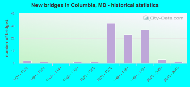
- New bridges - historical statistics
- 21920-1929
- 11930-1939
- 11950-1959
- 11960-1969
- 321970-1979
- 231980-1989
- 271990-1999
- 32000-2009
- 12010-2019
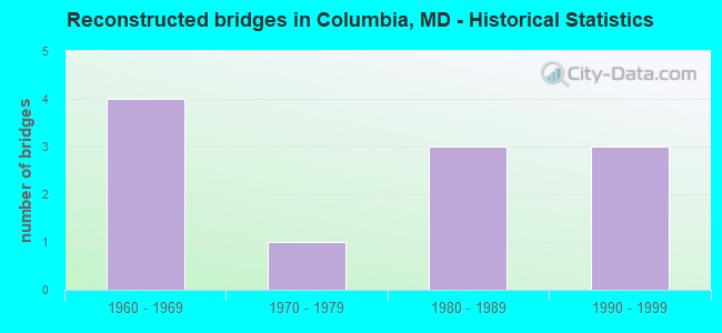
- Reconstructed bridges - Historical Statistics
- 41960-1969
- 11970-1979
- 31980-1989
- 31990-1999
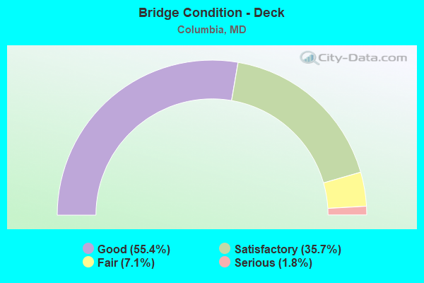
- Bridge Condition - Deck
- 55.4%Good
- 35.7%Satisfactory
- 7.1%Fair
- 1.8%Serious
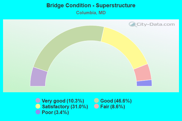
- Bridge Condition - Superstructure
- 10.3%Very good
- 46.6%Good
- 31.0%Satisfactory
- 8.6%Fair
- 3.4%Poor
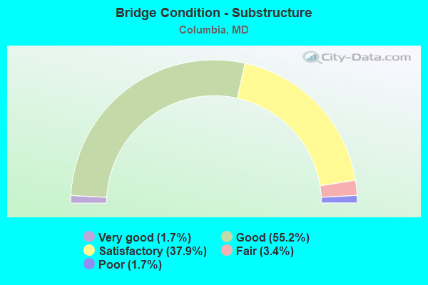
- Bridge Condition - Substructure
- 1.7%Very good
- 55.2%Good
- 37.9%Satisfactory
- 3.4%Fair
- 1.7%Poor
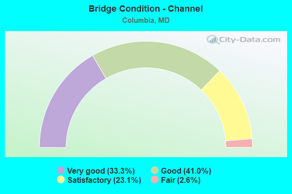
- Bridge Condition - Channel
- 33.3%Very good
- 41.0%Good
- 23.1%Satisfactory
- 2.6%Fair
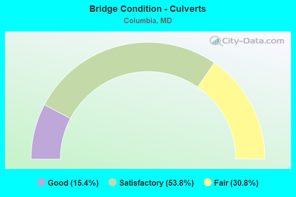
- Bridge Condition - Culverts
- 15.4%Good
- 53.8%Satisfactory
- 30.8%Fair
Find on map >> Show street view
Structure Number: 100000130144014, Location: 0.86 MILE WEST OF MD 103 (Lat: 39.212108, Lng: -76.795889), Route carried "on" structure: State highway 100, Year Built: 1997, Status: Open, Structure Length: 2.96m (9.71ft), Average Daily Traffic: 82,092 (year 2009), Truck Traffic: 10%, Average Future Daily Traffic: 44,034 (year 2026), Design Load: HS 25 or greater, Features Intersected: SNOWDEN RIVER PARKWAY
Minimum Vertical Clearance: 30+ m (98+ ft), Kilometerpoint: 5.860, Lanes on structure: 3, Lanes under structure: 2, Base Highway Network: Yes, Owner: State Highway Agency, Approaching Roadway Width: 17.1m (56.1ft), Material/Design: Steel, Design/Construction: Stringer/Multi-beam, Number Of Spans In Main Unit: 1, Length of Maximum Span: 29.6m (97.1ft), Curb-To-Curb Width: 17.3m (56.8ft), Out-to-Out Width: 18.6m (61.0ft)
Condition: Deck: Good, Superstructure: Good, Substructure: Good, Operating Rating: 76.6 metric tons, Method Used To Determine Operating Rating: Load Factor (LF), Inventory Rating: 45.8 metric tons, Method Used To Determine Inventory Rating: Load Factor (LF), Structural Evaluation: Better than present minimum criteria, Deck Geometry: Better than present minimum criteria, Underclear: Better than present minimum criteria, Approach Roadway Alignment: Equal to present desirable criteria, Designated Inspection Frequency: Every 24 months, Inspection Date: July 2021, Deck Structure Type: Concrete Cast-file-Place, Wearing Surface/Protective System: Wearing Surface: Monolithic Concrete, Deck Protection: Epoxy Coated Reinforcing
Find on map >> Show street view
Structure Number: 100000130145013, Location: 0.62 MILE WEST OF MD 103 (Lat: 39.209492, Lng: -76.793872), Route carried "on" structure: State highway 100, Year Built: 1997, Status: Open, Structure Length: 5.76m (18.90ft), Average Daily Traffic: 82,092 (year 2009), Truck Traffic: 10%, Average Future Daily Traffic: 44,034 (year 2026), Design Load: HS 25 or greater, Features Intersected: OLD MONT. RD & DEEP RUN
Minimum Vertical Clearance: 30+ m (98+ ft), Kilometerpoint: 6.253, Lanes on structure: 4, Lanes under structure: 2, Base Highway Network: Yes, Owner: State Highway Agency, Approaching Roadway Width: 17.1m (56.1ft), Skew: 4 degrees, Material/Design: Steel, Design/Construction: Stringer/Multi-beam, Number Of Spans In Main Unit: 1, Length of Maximum Span: 55.5m (182.1ft), Curb-To-Curb Width: 21.0m (68.9ft), Out-to-Out Width: 21.9m (71.9ft)
Condition: Deck: Good, Superstructure: Good, Substructure: Good, Channel: Very good, Inventory Rating: 57.6 metric tons, Method Used To Determine Inventory Rating: Load Factor (LF), Structural Evaluation: Better than present minimum criteria, Deck Geometry: Better than present minimum criteria, Underclear: Equal to present minimum criteria, Waterway Adequacy: Equal to present desirable criteria, Approach Roadway Alignment: Equal to present desirable criteria, Designated Inspection Frequency: Every 24 months, Inspection Date: September 2021, Deck Structure Type: Concrete Cast-file-Place, Wearing Surface/Protective System: Wearing Surface: Monolithic Concrete, Deck Protection: Epoxy Coated Reinforcing
Find on map >> Show street view
Structure Number: 100000130145014, Location: 0.62 MILE WEST OF MD 103 (Lat: 39.209506, Lng: -76.793311), Route carried "on" structure: State highway 100, Year Built: 1997, Status: Open, Structure Length: 4.79m (15.72ft), Average Daily Traffic: 82,092 (year 2009), Truck Traffic: 10%, Average Future Daily Traffic: 44,034 (year 2026), Design Load: HS 25 or greater, Features Intersected: OLD MONT. RD & DEEP RUN
Minimum Vertical Clearance: 30+ m (98+ ft), Kilometerpoint: 6.253, Lanes on structure: 4, Lanes under structure: 2, Base Highway Network: Yes, Owner: State Highway Agency, Approaching Roadway Width: 17.1m (56.1ft), Skew: 1 degrees, Material/Design: Steel, Design/Construction: Stringer/Multi-beam, Number Of Spans In Main Unit: 1, Length of Maximum Span: 46.0m (150.9ft), Curb-To-Curb Width: 22.1m (72.5ft), Out-to-Out Width: 22.2m (72.8ft)
Condition: Deck: Good, Superstructure: Good, Substructure: Good, Channel: Very good, Inventory Rating: 63.5 metric tons, Method Used To Determine Inventory Rating: Load Factor (LF), Structural Evaluation: Better than present minimum criteria, Deck Geometry: Equal to present desirable criteria, Underclear: Equal to present minimum criteria, Waterway Adequacy: Equal to present desirable criteria, Approach Roadway Alignment: Equal to present desirable criteria, Designated Inspection Frequency: Every 24 months, Inspection Date: September 2021, Deck Structure Type: Concrete Cast-file-Place, Wearing Surface/Protective System: Wearing Surface: Monolithic Concrete, Deck Protection: Epoxy Coated Reinforcing
Find on map >> Show street view
Structure Number: 10000013014601, Location: 1.35 MILE NORTH OF I-95 (Lat: 39.207611, Lng: -76.782558), Route carried "on" structure: State highway 100, Year Built: 1997, Status: Open, Structure Length: 7.56m (24.80ft), Average Daily Traffic: 12,911 (year 2009), Truck Traffic: 10%, Average Future Daily Traffic: 17,204 (year 2026), Design Load: HS 25 or greater, Features Intersected: MD 100, Facility Carried by Structure: MD 103
Minimum Vertical Clearance: 5.18m (16.99ft), Kilometerpoint: 5.197, Lanes on structure: 2, Lanes under structure: 6, Owner: State Highway Agency, Approaching Roadway Width: 15.2m (49.9ft), Skew: 1 degrees, Material/Design: Steel, Design/Construction: Stringer/Multi-beam, Number Of Spans In Main Unit: 2, Length of Maximum Span: 38.1m (125.0ft), Curb-To-Curb Width: 13.4m (44.0ft), Out-to-Out Width: 14.6m (47.9ft)
Condition: Deck: Good, Superstructure: Good, Substructure: Good, Inventory Rating: 63.9 metric tons, Method Used To Determine Inventory Rating: Load Factor (LF), Structural Evaluation: Better than present minimum criteria, Deck Geometry: Equal to present minimum criteria, Underclear: Better than present minimum criteria, Approach Roadway Alignment: Equal to present desirable criteria, Designated Inspection Frequency: Every 24 months, Inspection Date: September 2021, Deck Structure Type: Concrete Cast-file-Place, Wearing Surface/Protective System: Wearing Surface: Monolithic Concrete, Deck Protection: Epoxy Coated Reinforcing
Find on map >> Show street view
Structure Number: 100000130153013, Location: 0.84 MILE WEST OF MD 108 (Lat: 39.191064, Lng: -76.810939), Route carried "on" structure: State highway 175, Year Built: 2001, Status: Open, Structure Length: 6.86m (22.51ft), Average Daily Traffic: 30,855 (year 2012), Truck Traffic: 9%, Average Future Daily Traffic: 40,112 (year 2032), Design Load: HS 25 or greater, Features Intersected: SNOWDEN RIVER PARKWAY
Minimum Vertical Clearance: 30+ m (98+ ft), Kilometerpoint: 5.685, Lanes on structure: 4, Lanes under structure: 11, Base Highway Network: Yes, Owner: State Highway Agency, Approaching Roadway Width: 17.7m (58.1ft), Skew: 1 degrees, Material/Design: Steel continuous, Design/Construction: Girder and Floorbeam System, Number Of Spans In Main Unit: 2, Length of Maximum Span: 33.5m (109.9ft), Curb-To-Curb Width: 17.7m (58.1ft), Out-to-Out Width: 18.9m (62.0ft)
Condition: Deck: Good, Superstructure: Good, Substructure: Good, Inventory Rating: 55.8 metric tons, Method Used To Determine Inventory Rating: Load Factor (LF), Structural Evaluation: Better than present minimum criteria, Deck Geometry: Meets minimum limits, Underclear: High priority of corrective action, Approach Roadway Alignment: Equal to present desirable criteria, Designated Inspection Frequency: Every 24 months, Inspection Date: October 2021, Deck Structure Type: Concrete Cast-file-Place, Wearing Surface/Protective System: Wearing Surface: Monolithic Concrete, Deck Protection: Epoxy Coated Reinforcing
Find on map >> Show street view
Structure Number: 100000130153014, Location: 0.84 MILE WEST OF MD 108 (Lat: 39.191328, Lng: -76.811597), Route carried "on" structure: State highway 175, Year Built: 2001, Status: Open, Structure Length: 6.86m (22.51ft), Average Daily Traffic: 32,168 (year 2012), Truck Traffic: 9%, Average Future Daily Traffic: 41,819 (year 2032), Design Load: HS 25 or greater, Features Intersected: SNOWDEN RIVER PARKWAY
Minimum Vertical Clearance: 30+ m (98+ ft), Kilometerpoint: 5.685, Lanes on structure: 3, Lanes under structure: 9, Base Highway Network: Yes, Owner: State Highway Agency, Approaching Roadway Width: 15.2m (49.9ft), Skew: 1 degrees, Material/Design: Steel continuous, Design/Construction: Girder and Floorbeam System, Number Of Spans In Main Unit: 2, Length of Maximum Span: 33.5m (109.9ft), Curb-To-Curb Width: 15.2m (49.9ft), Out-to-Out Width: 16.5m (54.1ft)
Condition: Deck: Good, Superstructure: Good, Substructure: Good, Operating Rating: 88.0 metric tons, Method Used To Determine Operating Rating: Load Factor (LF), Inventory Rating: 52.6 metric tons, Method Used To Determine Inventory Rating: Load Factor (LF), Structural Evaluation: Better than present minimum criteria, Deck Geometry: Meets minimum limits, Underclear: High priority of corrective action, Approach Roadway Alignment: Equal to present desirable criteria, Designated Inspection Frequency: Every 24 months, Inspection Date: October 2021, Deck Structure Type: Concrete Cast-file-Place, Wearing Surface/Protective System: Wearing Surface: Monolithic Concrete, Deck Protection: Epoxy Coated Reinforcing
Find on map >> Show street view
Structure Number: 10000013015901, Location: 750' E TEN OAKS ROAD (Lat: 39.229950, Lng: -76.973783), Route carried "on" structure: County highway 2289, Year Built: 2013, Status: Open, Structure Length: 7.25m (23.79ft), Average Daily Traffic: 4,275 (year 2010), Average Future Daily Traffic: 6,400 (year 2030), Features Intersected: MD 32, Facility Carried by Structure: LINDEN CHURCH ROAD
Minimum Vertical Clearance: 30+ m (98+ ft), Kilometerpoint: 0.228, Lanes on structure: 2, Lanes under structure: 4, Owner: State Highway Agency, Approaching Roadway Width: 12.8m (42.0ft), Skew: 33 degrees, Material/Design: Steel continuous, Design/Construction: Stringer/Multi-beam, Number Of Spans In Main Unit: 2, Length of Maximum Span: 35.1m (115.2ft), Curb-To-Curb Width: 12.2m (40.0ft), Out-to-Out Width: 14.0m (45.9ft)
Condition: Deck: Good, Superstructure: Very good, Substructure: Very good, Operating Rating: 34.0 metric tons, Method Used To Determine Operating Rating: Load and Resistance Factor Rating (LRFR) rating reported by rating factor(RF) method using HL-93 loadings, Inventory Rating: 32.4 metric tons, Method Used To Determine Inventory Rating: Load and Resistance Factor Rating (LRFR) rating reported by rating factor(RF) method using HL-93 loadings, Structural Evaluation: Equal to present desirable criteria, Deck Geometry: Equal to present minimum criteria, Underclear: Somewhat better than minimum adequacy, Approach Roadway Alignment: Equal to present desirable criteria, Designated Inspection Frequency: Every 24 months, Inspection Date: June 2021, Deck Structure Type: Concrete Cast-file-Place, Wearing Surface/Protective System: Wearing Surface: Integral Concrete, Membrane: Built-up
Find on map >> Show street view
Structure Number: 200000HO000801, Location: 0.6 MI N OF MD RTE 108 (Lat: 39.226314, Lng: -76.936136), Route carried "on" structure: County highway 80, Year Built: 1997, Status: Open, Structure Length: 1.40m (4.59ft), Average Daily Traffic: 3,027 (year 2002), Truck Traffic: 4%, Average Future Daily Traffic: 3,600 (year 2011), Design Load: HS 25 or greater, Features Intersected: MIDDLE PATUXENT RIVER, Facility Carried by Structure: SHEPPARD LANE
Minimum Vertical Clearance: 30+ m (98+ ft), Kilometerpoint: 1.223, Lanes on structure: 2, Owner: County Highway Agency, Approaching Roadway Width: 7.3m (24.0ft), Skew: 3 degrees, Material/Design: Steel, Design/Construction: Stringer/Multi-beam, Number Of Spans In Main Unit: 1, Length of Maximum Span: 12.5m (41.0ft), Curb-To-Curb Width: 8.5m (27.9ft), Out-to-Out Width: 10.2m (33.5ft)
Condition: Deck: Good, Superstructure: Very good, Substructure: Good, Channel: Good, Inventory Rating: 87.5 metric tons, Method Used To Determine Inventory Rating: Load Factor (LF), Structural Evaluation: Better than present minimum criteria, Deck Geometry: Meets minimum limits, Waterway Adequacy: Equal to present desirable criteria, Approach Roadway Alignment: Equal to present desirable criteria, Length Of Structure Improvement: 30.48m (100.00ft), Designated Inspection Frequency: Every 24 months, Inspection Date: April 2021, Bridge Improvement Cost: $834,000, Roadway Improvement Cost: $207,000, Total Project Cost: $1,041,000, Deck Structure Type: Concrete Cast-file-Place, Wearing Surface/Protective System: Wearing Surface: Integral Concrete, Deck Protection: Epoxy Coated Reinforcing
Find on map >> Show street view
Structure Number: 200000HO001003, Location: 1.0 M N Snowden River Pkw (Lat: 39.187925, Lng: -76.829581), Route carried "on" structure: County highway 128, Year Built: 1975, Status: Open, Structure Length: 1.62m (5.31ft), Average Daily Traffic: 13,335 (year 1994), Truck Traffic: 4%, Average Future Daily Traffic: 14,010 (year 2010), Features Intersected: ELKHORN BRANCH OF LITTLE, Facility Carried by Structure: OAKLAND MILLS ROAD
Minimum Vertical Clearance: 30+ m (98+ ft), Kilometerpoint: 3.781, Lanes on structure: 4, Owner: County Highway Agency, Approaching Roadway Width: 13.4m (44.0ft), Material/Design: Steel, Design/Construction: Culvert, Number Of Spans In Main Unit: 3, Length of Maximum Span: 4.6m (15.1ft), Curb or Sidewalk Widths: Left: 0.1m (0.3ft), Right: 0.0m
Condition: Channel: Satisfactory, Culverts: Satisfactory, Structural Evaluation: Equal to present minimum criteria, Waterway Adequacy: Equal to present desirable criteria, Approach Roadway Alignment: Equal to present desirable criteria, Designated Inspection Frequency: Every 24 months, Inspection Date: March 2021
Find on map >> Show street view
Structure Number: 200000HO001101, Location: 0.04 MI W OF MD RTE 108 (Lat: 39.188256, Lng: -76.797628), Route carried "on" structure: County highway 129, Year Built: 1991, Status: Open, Structure Length: 1.52m (4.99ft), Average Daily Traffic: 6,274 (year 1995), Truck Traffic: 5%, Average Future Daily Traffic: 17,000 (year 2015), Design Load: HS 20, Features Intersected: DORSEY RUN, Facility Carried by Structure: LARK BROWN ROAD
Minimum Vertical Clearance: 30+ m (98+ ft), Kilometerpoint: 0.579, Lanes on structure: 4, Owner: County Highway Agency, Approaching Roadway Width: 13.4m (44.0ft), Material/Design: Steel, Design/Construction: Stringer/Multi-beam, Number Of Spans In Main Unit: 1, Length of Maximum Span: 15.2m (49.9ft), Curb or Sidewalk Widths: Left: 0.0m, Right: 1.6m (5.2ft), Curb-To-Curb Width: 13.4m (44.0ft), Out-to-Out Width: 15.8m (51.8ft)
Condition: Deck: Good, Superstructure: Very good, Substructure: Good, Channel: Good, Inventory Rating: 76.6 metric tons, Method Used To Determine Inventory Rating: Load Factor (LF), Structural Evaluation: Better than present minimum criteria, Deck Geometry: High priority of replacement, Waterway Adequacy: Equal to present desirable criteria, Approach Roadway Alignment: Equal to present desirable criteria, Designated Inspection Frequency: Every 24 months, Inspection Date: March 2021, Deck Structure Type: Concrete Cast-file-Place, Wearing Surface/Protective System: Wearing Surface: Integral Concrete, Deck Protection: Epoxy Coated Reinforcing
Find on map >> Show street view
Structure Number: 200000HO001601, Location: 1.3 MI N OF MD RTE 108 (Lat: 39.236772, Lng: -76.940508), Route carried "on" structure: County highway 80, Year Built: 1983, Status: Open, Structure Length: 0.98m (3.22ft), Average Daily Traffic: 3,124 (year 2002), Truck Traffic: 4%, Average Future Daily Traffic: 3,800 (year 2015), Features Intersected: MIDDLE PATUXENT RIVER, Facility Carried by Structure: SHEPPARD LANE
Minimum Vertical Clearance: 30+ m (98+ ft), Kilometerpoint: 1.963, Lanes on structure: 2, Owner: County Highway Agency, Approaching Roadway Width: 7.3m (24.0ft), Material/Design: Steel, Design/Construction: Stringer/Multi-beam, Number Of Spans In Main Unit: 1, Length of Maximum Span: 9.1m (29.9ft), Curb-To-Curb Width: 11.0m (36.1ft), Out-to-Out Width: 11.9m (39.0ft)
Condition: Deck: Good, Superstructure: Good, Substructure: Good, Channel: Satisfactory, Operating Rating: 74.8 metric tons, Method Used To Determine Operating Rating: Load Factor (LF), Inventory Rating: 44.9 metric tons, Method Used To Determine Inventory Rating: Load Factor (LF), Structural Evaluation: Better than present minimum criteria, Deck Geometry: Somewhat better than minimum adequacy, Waterway Adequacy: Equal to present minimum criteria, Approach Roadway Alignment: Equal to present desirable criteria, Designated Inspection Frequency: Every 24 months, Inspection Date: April 2021, Deck Structure Type: Concrete Cast-file-Place, Wearing Surface/Protective System: Wearing Surface: Monolithic Concrete, Deck Protection: Epoxy Coated Reinforcing
Find on map >> Show street view
Structure Number: 200000HO002001, Location: 2.7 MI S OF MD RTE 144 (Lat: 39.256247, Lng: -76.927728), Route carried "on" structure: County highway 80, Year Built: 1922, Status: Open, Structure Length: 1.95m (6.40ft), Average Daily Traffic: 3,489 (year 1999), Truck Traffic: 4%, Average Future Daily Traffic: 5,600 (year 2015), Features Intersected: MIDDLE PATUXENT RIVER, Facility Carried by Structure: FOLLY QUARTER RD
Minimum Vertical Clearance: 30+ m (98+ ft), Kilometerpoint: 3.170, Lanes on structure: 2, Owner: County Highway Agency, Approaching Roadway Width: 9.1m (29.9ft), Material/Design: Concrete, Design/Construction: Arch - Deck, Number Of Spans In Main Unit: 1, Length of Maximum Span: 18.3m (60.0ft), Curb-To-Curb Width: 7.3m (24.0ft), Out-to-Out Width: 8.1m (26.6ft)
Condition: Superstructure: Satisfactory, Substructure: Satisfactory, Channel: Good, Operating Rating: 32.7 metric tons, Method Used To Determine Operating Rating: Field evaluation and documented engineering judgment, Inventory Rating: 32.7 metric tons, Method Used To Determine Inventory Rating: Field evaluation and documented engineering judgment, Structural Evaluation: Equal to present minimum criteria, Deck Geometry: High priority of replacement, Waterway Adequacy: Somewhat better than minimum adequacy, Approach Roadway Alignment: Equal to present desirable criteria, Designated Inspection Frequency: Every 24 months, Inspection Date: April 2020
Find on map >> Show street view
Structure Number: 200000HO002202, Location: 0.4 MI W OF FOLLY QUARTER (Lat: 39.266333, Lng: -76.928736), Route carried "on" structure: County highway 74, Year Built: 1975, Status: Open, Structure Length: 1.25m (4.10ft), Average Daily Traffic: 1,346 (year 2000), Truck Traffic: 4%, Average Future Daily Traffic: 2,090 (year 2015), Features Intersected: MIDDLE PATUXENT RIVER, Facility Carried by Structure: CARROLL MILL ROAD
Minimum Vertical Clearance: 5.18m (16.99ft), Kilometerpoint: 2.060, Lanes on structure: 2, Owner: County Highway Agency, Approaching Roadway Width: 11.0m (36.1ft), Material/Design: Concrete, Design/Construction: Culvert, Length of Maximum Span: 6.1m (20.0ft), Curb-To-Curb Width: 11.0m (36.1ft), Out-to-Out Width: 11.6m (38.1ft)
Condition: Channel: Satisfactory, Culverts: Fair, Operating Rating: 54.0 metric tons, Method Used To Determine Operating Rating: Load Factor (LF), Inventory Rating: 32.2 metric tons, Method Used To Determine Inventory Rating: Load Factor (LF), Structural Evaluation: Somewhat better than minimum adequacy, Deck Geometry: Equal to present minimum criteria, Waterway Adequacy: Equal to present desirable criteria, Approach Roadway Alignment: Equal to present desirable criteria, Designated Inspection Frequency: Every 24 months, Inspection Date: April 2020, Deck Structure Type: Concrete Cast-file-Place, Wearing Surface/Protective System: Wearing Surface: Monolithic Concrete
Find on map >> Show street view
Structure Number: 200000HO003602, Location: 0.08 MILE WEST OF US 29 (Lat: 39.207906, Lng: -76.857081), Route carried "on" structure: ServiceState highway 986K, Year Built: 2004, Status: Open, Structure Length: 1.51m (4.95ft), Average Daily Traffic: 4,200 (year 2000), Truck Traffic: 5%, Average Future Daily Traffic: 6,750 (year 2020), Design Load: HS 25 or greater, Features Intersected: LITTLE PATUXENT RIVER, Facility Carried by Structure: SOUTH ENTRANCE ROA
Minimum Vertical Clearance: 30+ m (98+ ft), Kilometerpoint: 0.451, Lanes on structure: 2, Owner: County Highway Agency, Approaching Roadway Width: 12.2m (40.0ft), Skew: 2 degrees, Material/Design: Concrete, Design/Construction: Culvert, Number Of Spans In Main Unit: 3, Length of Maximum Span: 4.9m (16.1ft), Curb-To-Curb Width: 12.2m (40.0ft), Out-to-Out Width: 14.3m (46.9ft)
Condition: Channel: Fair, Culverts: Good, Operating Rating: 72.1 metric tons, Method Used To Determine Operating Rating: Load Factor (LF), Inventory Rating: 43.1 metric tons, Method Used To Determine Inventory Rating: Load Factor (LF), Structural Evaluation: Better than present minimum criteria, Deck Geometry: Equal to present minimum criteria, Waterway Adequacy: Equal to present minimum criteria, Approach Roadway Alignment: Equal to present desirable criteria, Designated Inspection Frequency: Every 24 months, Inspection Date: March 2021
Find on map >> Show street view
Structure Number: 200000HO005501, Location: 0.5 MI W OF US RTE 29 (Lat: 39.200697, Lng: -76.822008), Route carried "on" structure: County highway 83, Year Built: 1935, Year Reconstructed: 1982, Status: Posted for load, Structure Length: 0.74m (2.43ft), Average Daily Traffic: 10 (year 1993), Average Future Daily Traffic: 10 (year 2015), Design Load: H 15, Features Intersected: LITTLE PATUXENT RIVER, Facility Carried by Structure: OLD MONTGOMERY RD
Minimum Vertical Clearance: 30+ m (98+ ft), Kilometerpoint: 3.524, Lanes on structure: 2, Owner: County Highway Agency, Approaching Roadway Width: 6.1m (20.0ft), Skew: 1 degrees, Material/Design: Steel, Design/Construction: Stringer/Multi-beam, Number Of Spans In Main Unit: 1, Length of Maximum Span: 6.4m (21.0ft), Curb or Sidewalk Widths: Left: 0.2m (0.7ft), Right: 0.2m (0.7ft), Curb-To-Curb Width: 5.9m (19.4ft), Out-to-Out Width: 6.3m (20.7ft)
Condition: Deck: Serious, Superstructure: Poor, Substructure: Fair, Channel: Satisfactory, Operating Rating: 16.8 metric tons, Method Used To Determine Operating Rating: Load Factor (LF), Inventory Rating: 10.0 metric tons, Method Used To Determine Inventory Rating: Load Factor (LF), Structural Evaluation: High priority of corrective action, Deck Geometry: Meets minimum limits, Waterway Adequacy: Equal to present minimum criteria, Approach Roadway Alignment: Equal to present desirable criteria, Length Of Structure Improvement: 0.73m (2.40ft), Designated Inspection Frequency: Every 24 months, Other Special Inspection Frequency: Every 12 months, Inspection Date: March 2021, Other Special Inspection Date: March 2021, Bridge Improvement Cost: $2,000, Total Project Cost: $2,000, Deck Structure Type: Corrugated Steel, Wearing Surface/Protective System: Wearing Surface: Bituminous
Find on map >> Show street view
Structure Number: 200000HO006401, Location: 0.01 MI E OF US RTE 29 (Lat: 39.168264, Lng: -76.883219), Route carried "on" structure: County highway 78, Year Built: 1920, Status: Open, Structure Length: 1.37m (4.49ft), Average Daily Traffic: 3,484 (year 2019), Truck Traffic: 4%, Average Future Daily Traffic: 1,130 (year 2010), Features Intersected: MIDDLE PATUXENT RIVER, Facility Carried by Structure: OLD COLUMBIA ROAD
Minimum Vertical Clearance: 30+ m (98+ ft), Kilometerpoint: 1.207, Lanes on structure: 2, Owner: County Highway Agency, Approaching Roadway Width: 7.3m (24.0ft), Material/Design: Concrete, Design/Construction: Arch - Deck, Number Of Spans In Main Unit: 1, Length of Maximum Span: 13.7m (44.9ft), Curb-To-Curb Width: 4.7m (15.4ft), Out-to-Out Width: 5.3m (17.4ft)
Condition: Superstructure: Fair, Substructure: Good, Channel: Satisfactory, Operating Rating: 32.7 metric tons, Method Used To Determine Operating Rating: Field evaluation and documented engineering judgment, Inventory Rating: 32.7 metric tons, Method Used To Determine Inventory Rating: Field evaluation and documented engineering judgment, Structural Evaluation: Somewhat better than minimum adequacy, Deck Geometry: High priority of replacement, Waterway Adequacy: Somewhat better than minimum adequacy, Approach Roadway Alignment: Equal to present minimum criteria, Designated Inspection Frequency: Every 24 months, Inspection Date: March 2020
Find on map >> Show street view
Structure Number: 200000HO007803, Location: .03 MI W OF YOUNGHEART (Lat: 39.195056, Lng: -76.848436), Route carried "on" structure: County highway 1173, Year Built: 1972, Status: Open, Structure Length: 0.72m (2.36ft), Average Daily Traffic: 915 (year 1995), Truck Traffic: 4%, Average Future Daily Traffic: 915 (year 2015), Features Intersected: LITTLE PATUXENT RIVER, Facility Carried by Structure: SANDCHAIN ROAD
Minimum Vertical Clearance: 30+ m (98+ ft), Kilometerpoint: 0.483, Lanes on structure: 2, Owner: County Highway Agency, Approaching Roadway Width: 8.5m (27.9ft), Skew: 1 degrees, Material/Design: Steel, Design/Construction: Culvert, Number Of Spans In Main Unit: 2, Length of Maximum Span: 3.0m (9.8ft), Curb or Sidewalk Widths: Left: 1.5m (4.9ft), Right: 1.5m (4.9ft)
Condition: Channel: Satisfactory, Culverts: Fair, Structural Evaluation: Somewhat better than minimum adequacy, Waterway Adequacy: Somewhat better than minimum adequacy, Approach Roadway Alignment: Equal to present desirable criteria, Designated Inspection Frequency: Every 24 months, Inspection Date: March 2020
Find on map >> Show street view
Structure Number: 200000HO010901, Location: 0.1 MI E PHELPS LUCK (Lat: 39.213303, Lng: -76.820700), Route carried "on" structure: County highway 991, Year Built: 1970, Status: Open, Structure Length: 1.64m (5.38ft), Average Daily Traffic: 10,941 (year 1999), Truck Traffic: 4%, Average Future Daily Traffic: 16,000 (year 2015), Design Load: HS 20, Features Intersected: UNNAMED STREAM, Facility Carried by Structure: TAMAR DRIVE
Minimum Vertical Clearance: 30+ m (98+ ft), Kilometerpoint: 1.110, Lanes on structure: 2, Owner: County Highway Agency, Approaching Roadway Width: 13.4m (44.0ft), Material/Design: Steel, Design/Construction: Stringer/Multi-beam, Number Of Spans In Main Unit: 1, Length of Maximum Span: 15.9m (52.2ft), Curb or Sidewalk Widths: Left: 1.8m (5.9ft), Right: 1.8m (5.9ft), Curb-To-Curb Width: 13.4m (44.0ft), Out-to-Out Width: 17.7m (58.1ft)
Condition: Deck: Satisfactory, Superstructure: Poor, Substructure: Poor, Channel: Very good, Inventory Rating: 60.8 metric tons, Method Used To Determine Inventory Rating: Load Factor (LF), Structural Evaluation: Meets minimum limits, Deck Geometry: Equal to present minimum criteria, Waterway Adequacy: Equal to present desirable criteria, Approach Roadway Alignment: Equal to present desirable criteria, Designated Inspection Frequency: Every 24 months, Inspection Date: March 2021, Deck Structure Type: Concrete Cast-file-Place, Wearing Surface/Protective System: Wearing Surface: Monolithic Concrete
Find on map >> Show street view
Structure Number: 200000HO011201, Location: 0.4 MI E BROKENLAND PKWY (Lat: 39.185722, Lng: -76.843586), Route carried "on" structure: County highway 1160, Year Built: 1972, Status: Open, Structure Length: 1.71m (5.61ft), Average Daily Traffic: 8,471 (year 2000), Truck Traffic: 4%, Average Future Daily Traffic: 18,036 (year 2010), Design Load: HS 20, Features Intersected: UNNAMED STREAM, Facility Carried by Structure: CRADLEROCK WAY
Minimum Vertical Clearance: 30+ m (98+ ft), Kilometerpoint: 0.595, Lanes on structure: 2, Owner: County Highway Agency, Approaching Roadway Width: 13.1m (43.0ft), Material/Design: Steel, Design/Construction: Stringer/Multi-beam, Number Of Spans In Main Unit: 1, Length of Maximum Span: 15.9m (52.2ft), Curb or Sidewalk Widths: Left: 1.8m (5.9ft), Right: 1.8m (5.9ft), Curb-To-Curb Width: 13.0m (42.7ft), Out-to-Out Width: 17.3m (56.8ft)
Condition: Deck: Fair, Superstructure: Satisfactory, Substructure: Good, Channel: Satisfactory, Inventory Rating: 59.9 metric tons, Method Used To Determine Inventory Rating: Load Factor (LF), Structural Evaluation: Equal to present minimum criteria, Deck Geometry: Somewhat better than minimum adequacy, Waterway Adequacy: Equal to present desirable criteria, Approach Roadway Alignment: Equal to present desirable criteria, Designated Inspection Frequency: Every 24 months, Inspection Date: March 2020, Deck Structure Type: Concrete Cast-file-Place
Find on map >> Show street view
Structure Number: 200000HO012601, Location: 1.0 MI S OF MD RTE 175 (Lat: 39.180758, Lng: -76.824731), Route carried "on" structure: County highway , Year Built: 1976, Status: Open, Structure Length: 4.09m (13.42ft), Average Daily Traffic: 35,944 (year 1999), Truck Traffic: 10%, Average Future Daily Traffic: 12,100 (year 2010), Design Load: HS 20, Features Intersected: ROBERT FULTON DRIVE, Facility Carried by Structure: SNOWDEN RIVER PARK
Minimum Vertical Clearance: 30+ m (98+ ft), Kilometerpoint: 0.000, Lanes on structure: 3, Lanes under structure: 2, Owner: County Highway Agency, Approaching Roadway Width: 12.8m (42.0ft), Material/Design: Steel, Design/Construction: Stringer/Multi-beam, Number Of Spans In Main Unit: 3, Length of Maximum Span: 23.5m (77.1ft), Curb-To-Curb Width: 12.9m (42.3ft), Out-to-Out Width: 13.7m (44.9ft)
Condition: Deck: Good, Superstructure: Fair, Substructure: Satisfactory, Operating Rating: 32.7 metric tons, Method Used To Determine Operating Rating: Allowable Stress (AS), Inventory Rating: 18.6 metric tons, Method Used To Determine Inventory Rating: Allowable Stress (AS), Structural Evaluation: Meets minimum limits, Deck Geometry: Meets minimum limits, Underclear: Meets minimum limits, Approach Roadway Alignment: Equal to present desirable criteria, Designated Inspection Frequency: Every 24 months, Other Special Inspection Frequency: Every 12 months, Inspection Date: March 2021, Other Special Inspection Date: March 2021, Deck Structure Type: Concrete Cast-file-Place, Wearing Surface/Protective System: Wearing Surface: Integral Concrete
Find on map >> Show street view
Structure Number: 200000HO012801, Location: 1.0 MI S OF MD RTE 175 (Lat: 39.180353, Lng: -76.824831), Route carried "on" structure: County highway , Year Built: 1975, Status: Open, Structure Length: 4.25m (13.94ft), Average Daily Traffic: 35,944 (year 1999), Truck Traffic: 10%, Average Future Daily Traffic: 12,100 (year 2010), Features Intersected: ROBERT FULTON DRIVE, Facility Carried by Structure: SNOWDEN RIVER PARK
Minimum Vertical Clearance: 30+ m (98+ ft), Kilometerpoint: 0.000, Lanes on structure: 2, Lanes under structure: 2, Owner: County Highway Agency, Approaching Roadway Width: 10.4m (34.1ft), Material/Design: Steel, Design/Construction: Stringer/Multi-beam, Number Of Spans In Main Unit: 3, Length of Maximum Span: 23.5m (77.1ft), Curb-To-Curb Width: 10.4m (34.1ft), Out-to-Out Width: 11.4m (37.4ft)
Condition: Deck: Satisfactory, Superstructure: Satisfactory, Substructure: Fair, Operating Rating: 73.9 metric tons, Method Used To Determine Operating Rating: Load Factor (LF), Inventory Rating: 44.4 metric tons, Method Used To Determine Inventory Rating: Load Factor (LF), Structural Evaluation: Somewhat better than minimum adequacy, Deck Geometry: Somewhat better than minimum adequacy, Underclear: Better than present minimum criteria, Approach Roadway Alignment: Equal to present desirable criteria, Designated Inspection Frequency: Every 24 months, Inspection Date: March 2021, Deck Structure Type: Concrete Cast-file-Place, Wearing Surface/Protective System: Wearing Surface: Monolithic Concrete
Find on map >> Show street view
Structure Number: 200000HO013101, Location: 0.04 MI N BERGER RD (Lat: 39.168322, Lng: -76.850700), Route carried "on" structure: County highway , Year Built: 1982, Status: Open, Structure Length: 10.19m (33.43ft), Average Daily Traffic: 8,192 (year 2002), Truck Traffic: 4%, Average Future Daily Traffic: 11,000 (year 2037), Design Load: HS 20, Features Intersected: MIDDLE PATUXENT RIVER, Facility Carried by Structure: GUILFORD ROAD
Minimum Vertical Clearance: 30+ m (98+ ft), Kilometerpoint: 0.000, Lanes on structure: 2, Owner: County Highway Agency, Approaching Roadway Width: 13.4m (44.0ft), Material/Design: Steel continuous, Design/Construction: Stringer/Multi-beam, Number Of Spans In Main Unit: 4, Length of Maximum Span: 27.4m (89.9ft), Curb-To-Curb Width: 13.4m (44.0ft), Out-to-Out Width: 14.4m (47.2ft)
Condition: Deck: Good, Superstructure: Good, Substructure: Good, Channel: Satisfactory, Operating Rating: 59.4 metric tons, Method Used To Determine Operating Rating: Load Factor (LF), Inventory Rating: 35.8 metric tons, Method Used To Determine Inventory Rating: Load Factor (LF), Structural Evaluation: Better than present minimum criteria, Deck Geometry: Equal to present minimum criteria, Waterway Adequacy: Equal to present desirable criteria, Approach Roadway Alignment: Equal to present desirable criteria, Designated Inspection Frequency: Every 24 months, Inspection Date: March 2020, Deck Structure Type: Concrete Cast-file-Place, Wearing Surface/Protective System: Wearing Surface: Integral Concrete, Deck Protection: Epoxy Coated Reinforcing
Find on map >> Show street view
Structure Number: 200000HO013701, Location: 0.5 MI N OF L. PATUX PKWY (Lat: 39.230969, Lng: -76.851525), Route carried "on" structure: County highway , Year Built: 1987, Status: Open, Structure Length: 4.84m (15.88ft), Average Daily Traffic: 6,934 (year 2002), Truck Traffic: 4%, Average Future Daily Traffic: 12,500 (year 2015), Features Intersected: LITTLE PATUXENT RIVER, Facility Carried by Structure: COLUMBIA ROAD
Minimum Vertical Clearance: 30+ m (98+ ft), Kilometerpoint: 0.000, Lanes on structure: 2, Owner: County Highway Agency, Approaching Roadway Width: 13.4m (44.0ft), Skew: 3 degrees, Material/Design: Steel, Design/Construction: Stringer/Multi-beam, Number Of Spans In Main Unit: 2, Length of Maximum Span: 23.5m (77.1ft), Curb or Sidewalk Widths: Left: 1.6m (5.2ft), Right: 1.6m (5.2ft), Curb-To-Curb Width: 13.4m (44.0ft), Out-to-Out Width: 17.3m (56.8ft)
Condition: Deck: Good, Superstructure: Very good, Substructure: Good, Channel: Good, Operating Rating: 55.8 metric tons, Method Used To Determine Operating Rating: Load Factor (LF), Inventory Rating: 33.6 metric tons, Method Used To Determine Inventory Rating: Load Factor (LF), Structural Evaluation: Better than present minimum criteria, Deck Geometry: Equal to present minimum criteria, Waterway Adequacy: Equal to present desirable criteria, Approach Roadway Alignment: Equal to present desirable criteria, Designated Inspection Frequency: Every 24 months, Inspection Date: March 2020, Deck Structure Type: Concrete Cast-file-Place, Wearing Surface/Protective System: Wearing Surface: Monolithic Concrete, Deck Protection: Epoxy Coated Reinforcing
Find on map >> Show street view
Structure Number: 200000HO014303, Location: 0.1 MI W OF OLD MONGOMER (Lat: 39.202653, Lng: -76.801556), Route carried "on" structure: County highway , Year Built: 1989, Status: Open, Structure Length: 1.37m (4.49ft), Average Daily Traffic: 11,824 (year 1999), Truck Traffic: 8%, Average Future Daily Traffic: 11,000 (year 2011), Features Intersected: DORSEY RUN, Facility Carried by Structure: TAMAR DRIVE
Minimum Vertical Clearance: 4.27m (14.01ft), Kilometerpoint: 0.000, Lanes on structure: 2, Owner: County Highway Agency, Approaching Roadway Width: 11.0m (36.1ft), Skew: 4 degrees, Material/Design: Steel, Design/Construction: Culvert, Number Of Spans In Main Unit: 3, Length of Maximum Span: 3.7m (12.1ft), Curb or Sidewalk Widths: Left: 1.2m (3.9ft), Right: 0.0m
Condition: Channel: Good, Culverts: Fair, Structural Evaluation: Somewhat better than minimum adequacy, Waterway Adequacy: Equal to present desirable criteria, Approach Roadway Alignment: Equal to present desirable criteria, Designated Inspection Frequency: Every 24 months, Inspection Date: March 2021
Find on map >> Show street view
Structure Number: 200000HO014503, Location: 0.3 MI W OF MD RTE 108 (Lat: 39.193772, Lng: -76.797856), Route carried "on" structure: County highway , Year Built: 1990, Status: Open, Structure Length: 1.05m (3.44ft), Average Daily Traffic: 605 (year 1999), Truck Traffic: 2%, Average Future Daily Traffic: 644 (year 2015), Features Intersected: DORSEY RUN, Facility Carried by Structure: SUMMER CLOUD WAY
Minimum Vertical Clearance: 30+ m (98+ ft), Kilometerpoint: 0.000, Lanes on structure: 2, Owner: County Highway Agency, Approaching Roadway Width: 9.1m (29.9ft), Skew: 1 degrees, Material/Design: Steel, Design/Construction: Culvert, Number Of Spans In Main Unit: 3, Length of Maximum Span: 2.7m (8.9ft), Curb or Sidewalk Widths: Left: 1.2m (3.9ft), Right: 1.2m (3.9ft)
Condition: Channel: Good, Culverts: Fair, Structural Evaluation: Somewhat better than minimum adequacy, Waterway Adequacy: Better than present minimum criteria, Approach Roadway Alignment: Equal to present desirable criteria, Designated Inspection Frequency: Every 24 months, Inspection Date: March 2021
Find on map >> Show street view
Structure Number: 200000HO014901, Location: 0.1 MI E OF US 29 (Lat: 39.199411, Lng: -76.855803), Route carried "on" structure: County highway , Year Built: 1990, Status: Open, Structure Length: 6.22m (20.41ft), Average Daily Traffic: 5,350 (year 1999), Truck Traffic: 4%, Average Future Daily Traffic: 5,700 (year 2015), Design Load: HS 20+Mod, Features Intersected: LITTLE PATUXENT RIVER, Facility Carried by Structure: STEVENS FOREST ROA
Minimum Vertical Clearance: 30+ m (98+ ft), Kilometerpoint: 0.000, Lanes on structure: 2, Owner: County Highway Agency, Approaching Roadway Width: 11.6m (38.1ft), Material/Design: Steel continuous, Design/Construction: Stringer/Multi-beam, Number Of Spans In Main Unit: 2, Length of Maximum Span: 30.5m (100.1ft), Curb-To-Curb Width: 11.6m (38.1ft), Out-to-Out Width: 12.8m (42.0ft)
Condition: Deck: Good, Superstructure: Very good, Substructure: Good, Channel: Good, Operating Rating: 71.7 metric tons, Method Used To Determine Operating Rating: Load Factor (LF), Inventory Rating: 42.6 metric tons, Method Used To Determine Inventory Rating: Load Factor (LF), Structural Evaluation: Better than present minimum criteria, Deck Geometry: Somewhat better than minimum adequacy, Waterway Adequacy: Superior to present desirable criteria, Approach Roadway Alignment: Equal to present desirable criteria, Designated Inspection Frequency: Every 24 months, Inspection Date: March 2020, Deck Structure Type: Concrete Cast-file-Place, Wearing Surface/Protective System: Wearing Surface: Monolithic Concrete, Deck Protection: Epoxy Coated Reinforcing
Find on map >> Show street view
Structure Number: 200000HO015201, Location: 0.125 MI S OF MD RTE 32 (Lat: 39.170083, Lng: -76.853225), Route carried "on" structure: County highway , Year Built: 1986, Status: Open, Structure Length: 9.88m (32.41ft), Average Daily Traffic: 21,288 (year 2000), Truck Traffic: 5%, Average Future Daily Traffic: 29,000 (year 2015), Design Load: HS 20, Features Intersected: LITTLE PATUXENT RIVER, Facility Carried by Structure: BROKEN LAND PKWY
Minimum Vertical Clearance: 30+ m (98+ ft), Kilometerpoint: 0.000, Lanes on structure: 2, Owner: County Highway Agency, Approaching Roadway Width: 12.2m (40.0ft), Material/Design: Steel continuous, Design/Construction: Stringer/Multi-beam, Number Of Spans In Main Unit: 3, Length of Maximum Span: 36.6m (120.1ft), Curb-To-Curb Width: 12.2m (40.0ft), Out-to-Out Width: 13.2m (43.3ft)
Condition: Deck: Good, Superstructure: Very good, Substructure: Good, Channel: Good, Operating Rating: 78.0 metric tons, Method Used To Determine Operating Rating: Load Factor (LF), Inventory Rating: 46.7 metric tons, Method Used To Determine Inventory Rating: Load Factor (LF), Structural Evaluation: Better than present minimum criteria, Deck Geometry: Somewhat better than minimum adequacy, Waterway Adequacy: Superior to present desirable criteria, Approach Roadway Alignment: Equal to present desirable criteria, Designated Inspection Frequency: Every 24 months, Inspection Date: April 2021, Deck Structure Type: Concrete Cast-file-Place, Wearing Surface/Protective System: Wearing Surface: Integral Concrete, Deck Protection: Epoxy Coated Reinforcing
Find on map >> Show street view
Structure Number: 200000HO015503, Location: 0.2 MI N OF GOV WARFIELD (Lat: 39.223092, Lng: -76.857625), Route carried "on" structure: Other road , Year Built: 1967, Status: Open, Structure Length: 1.25m (4.10ft), Average Daily Traffic: 31,936 (year 1997), Truck Traffic: 4%, Average Future Daily Traffic: 46,000 (year 2015), Features Intersected: WILDE LAKE BRANCH, Facility Carried by Structure: LITTLE PATUXENT PA
Minimum Vertical Clearance: 30+ m (98+ ft), Kilometerpoint: 0.000, Lanes on structure: 6, Owner: County Highway Agency, Approaching Roadway Width: 28.3m (92.8ft), Skew: 23 degrees, Material/Design: Steel, Design/Construction: Culvert, Number Of Spans In Main Unit: 2, Length of Maximum Span: 4.9m (16.1ft), Curb or Sidewalk Widths: Left: 1.5m (4.9ft), Right: 1.5m (4.9ft)
Condition: Channel: Good, Culverts: Satisfactory, Structural Evaluation: Equal to present minimum criteria, Waterway Adequacy: Equal to present desirable criteria, Approach Roadway Alignment: Equal to present desirable criteria, Designated Inspection Frequency: Every 24 months, Inspection Date: March 2020
Find on map >> Show street view
Structure Number: 200000HO017903, Location: .01 MI S FOLLY QUARTER RD (Lat: 39.257161, Lng: -76.966261), Route carried "on" structure: County highway , Year Built: 1985, Status: Open, Structure Length: 0.94m (3.08ft), Average Daily Traffic: 395 (year 1998), Truck Traffic: 4%, Average Future Daily Traffic: 425 (year 2015), Design Load: HS 20, Features Intersected: BENSON BRANCH, Facility Carried by Structure: BUCKSKIN LAKE DRIV
Minimum Vertical Clearance: 30+ m (98+ ft), Kilometerpoint: 0.000, Lanes on structure: 2, Owner: County Highway Agency, Approaching Roadway Width: 13.7m (44.9ft), Material/Design: Steel, Design/Construction: Culvert, Number Of Spans In Main Unit: 3, Length of Maximum Span: 2.4m (7.9ft)
Condition: Channel: Good, Culverts: Good, Structural Evaluation: Better than present minimum criteria, Waterway Adequacy: Equal to present minimum criteria, Approach Roadway Alignment: Equal to present desirable criteria, Designated Inspection Frequency: Every 24 months, Inspection Date: April 2020
Find on map >> Show street view
Structure Number: 100000130061013, Location: 1.38 M S OF MD 103 (Lat: 39.177967, Lng: -76.788578), Route carried "under" structure: Interstate 95, Year Built: 1970, Structure Length: 0. m, Average Daily Traffic: 197,902 (year 2012), Features Intersected: IS 95, Facility Carried by Structure: MD 175 EB
Minimum Vertical Clearance: 4.88m (16.01ft), Kilometerpoint: 10.433, Lanes on structure: 4, Lanes under structure: 10, Material/Design: Steel continuous, Design/Construction: Stringer/Multi-beam, Length of Maximum Span: 50.9m (167.0ft)
Find on map >> Show street view
Structure Number: 100000130061014, Location: 1.28 M S OF MD 103 (Lat: 39.177861, Lng: -76.790631), Route carried "under" structure: Interstate 95, Year Built: 1970, Structure Length: 0. m, Average Daily Traffic: 197,902 (year 2012), Features Intersected: IS 95, Facility Carried by Structure: MD 175 WB
Minimum Vertical Clearance: 4.57m (14.99ft), Kilometerpoint: 10.272, Lanes on structure: 4, Lanes under structure: 10, Material/Design: Steel continuous, Design/Construction: Stringer/Multi-beam, Length of Maximum Span: 50.9m (167.0ft)
Find on map >> Show street view
Structure Number: 10000013007301, Location: 0.71 MILE SOUTH OF MD 32 (Lat: 39.154608, Lng: -76.837450), Route carried "under" structure: Interstate 95, Year Built: 1970, Structure Length: 0. m, Average Daily Traffic: 186,750 (year 2009), Features Intersected: IS 95 SBR, Facility Carried by Structure: VOLLMERHAUSEN RD
Minimum Vertical Clearance: 4.88m (16.01ft), Kilometerpoint: 5.422, Lanes on structure: 2, Lanes under structure: 8, Material/Design: Steel continuous, Design/Construction: Stringer/Multi-beam, Length of Maximum Span: 34.7m (113.8ft)
Find on map >> Show street view
Structure Number: 100000130086013, Location: 1.11 M S OF MD 108 (Lat: 39.225497, Lng: -76.845333), Route carried "under" structure: US 29, Year Built: 1974, Structure Length: 0. m, Average Daily Traffic: 84,163 (year 2009), Features Intersected: US 29, Facility Carried by Structure: MD 175 EBR
Minimum Vertical Clearance: 5.18m (16.99ft), Kilometerpoint: 12.454, Lanes on structure: 2, Lanes under structure: 4, Material/Design: Steel continuous, Design/Construction: Stringer/Multi-beam, Length of Maximum Span: 29.3m (96.1ft)
Find on map >> Show street view
Structure Number: 100000130086014, Location: 1.11 M S OF MD 108 (Lat: 39.225592, Lng: -76.846281), Route carried "under" structure: US 29, Year Built: 1974, Structure Length: 0. m, Average Daily Traffic: 84,163 (year 2009), Features Intersected: US 29, Facility Carried by Structure: MD 175 WBR
Minimum Vertical Clearance: 5.18m (16.99ft), Kilometerpoint: 12.454, Lanes on structure: 2, Lanes under structure: 4, Material/Design: Steel continuous, Design/Construction: Stringer/Multi-beam, Length of Maximum Span: 29.3m (96.1ft)
Find on map >> Show street view
Structure Number: 100000130100013, Location: 1.0 MI N OF IS 95 (Lat: 39.166833, Lng: -76.839361), Route carried "under" structure: County highway 1834, Year Built: 1980, Structure Length: 0. m, Average Daily Traffic: 4,180 (year 2006), Features Intersected: GUILFORD ROAD, Facility Carried by Structure: MD 32 EBR
Minimum Vertical Clearance: 5.49m (18.01ft), Kilometerpoint: 1.802, Lanes on structure: 2, Lanes under structure: 2, Material/Design: Steel, Design/Construction: Stringer/Multi-beam, Length of Maximum Span: 26.2m (86.0ft)
Find on map >> Show street view
Structure Number: 100000130100014, Location: 1.0 MI N OF IS 95 (Lat: 39.166922, Lng: -76.838817), Route carried "under" structure: County highway 1834, Year Built: 1980, Structure Length: 0. m, Average Daily Traffic: 4,180 (year 2006), Features Intersected: GUILFORD ROAD, Facility Carried by Structure: MD 32 WBR
Minimum Vertical Clearance: 5.18m (16.99ft), Kilometerpoint: 1.754, Lanes on structure: 2, Lanes under structure: 2, Material/Design: Steel, Design/Construction: Stringer/Multi-beam, Length of Maximum Span: 26.2m (86.0ft)
Find on map >> Show street view
Structure Number: 100000130101013, Location: 2.93 MILE NORTH OF MD 216 (Lat: 39.181531, Lng: -76.874981), Route carried "under" structure: US 29, Year Built: 1980, Structure Length: 0. m, Average Daily Traffic: 66,903 (year 2009), Features Intersected: US 29, Facility Carried by Structure: MD 32 EBR
Minimum Vertical Clearance: 5.18m (16.99ft), Kilometerpoint: 6.935, Lanes on structure: 2, Lanes under structure: 4, Material/Design: Steel continuous, Design/Construction: Stringer/Multi-beam, Length of Maximum Span: 32.9m (107.9ft)
Find on map >> Show street view
Structure Number: 100000130101014, Location: 3.22 MI N OF IS 95 (Lat: 39.181700, Lng: -76.874022), Route carried "under" structure: US 29, Year Built: 1980, Structure Length: 0. m, Average Daily Traffic: 66,903 (year 2009), Features Intersected: US 29, Facility Carried by Structure: MD 32 WBR
Minimum Vertical Clearance: 5.49m (18.01ft), Kilometerpoint: 6.870, Lanes on structure: 2, Lanes under structure: 4, Material/Design: Steel continuous, Design/Construction: Stringer/Multi-beam, Length of Maximum Span: 32.9m (107.9ft)
Find on map >> Show street view
Structure Number: 10000013010201, Location: 0.75 MI N OF MD 732 (Lat: 39.175883, Lng: -76.860161), Route carried "under" structure: State highway 32, Year Built: 1981, Structure Length: 0. m, Average Daily Traffic: 81,712 (year 2009), Features Intersected: MD 32, Facility Carried by Structure: SHAKER DR
Minimum Vertical Clearance: 30+ m (98+ ft), Kilometerpoint: 8.721, Lanes on structure: 2, Lanes under structure: 12, Material/Design: Steel continuous, Design/Construction: Stringer/Multi-beam, Length of Maximum Span: 34.1m (111.9ft)
Find on map >> Show street view
Structure Number: 10000013010301, Location: 0.47 MI N OF MD 732A (Lat: 39.173706, Lng: -76.850397), Route carried "under" structure: State highway 32, Year Built: 1981, Structure Length: 0. m, Average Daily Traffic: 81,712 (year 2009), Features Intersected: MD 32, Facility Carried by Structure: BROKEN LAND PKWY
Minimum Vertical Clearance: 30+ m (98+ ft), Kilometerpoint: 7.836, Lanes on structure: 2, Lanes under structure: 12, Material/Design: Steel continuous, Design/Construction: Stringer/Multi-beam, Length of Maximum Span: 34.1m (111.9ft)
Find on map >> Show street view
Structure Number: 10000013012401, Location: 0.71 MILE SOUTH OF MD 32 (Lat: 39.154608, Lng: -76.837450), Route carried "under" structure: Interstate 95, Year Built: 1970, Structure Length: 0. m, Average Daily Traffic: 186,750 (year 2009), Truck Traffic: 8%, Features Intersected: IS 95 NBR, Facility Carried by Structure: VOLLMERHAUSEN ROAD
Minimum Vertical Clearance: 4.88m (16.01ft), Kilometerpoint: 5.422, Lanes on structure: 2, Lanes under structure: 4, Material/Design: Steel continuous, Design/Construction: Stringer/Multi-beam, Length of Maximum Span: 32.3m (106.0ft)
Find on map >> Show street view
Structure Number: 10000013012701, Location: 1.64 miles north of md 32 (Lat: 39.201186, Lng: -76.857558), Route carried "under" structure: Ramp US 29, Year Built: 1992, Structure Length: 0. m, Average Daily Traffic: 13,596 (year 2006), Truck Traffic: 8%, Features Intersected: US 29 RAMP 'D'(1), Facility Carried by Structure: BROKEN LAND PK'WY
Minimum Vertical Clearance: 5.18m (16.99ft), Kilometerpoint: 9.574, Lanes on structure: 5, Lanes under structure: 2, Material/Design: Steel, Design/Construction: Stringer/Multi-beam, Length of Maximum Span: 25.9m (85.0ft)
Find on map >> Show street view
Structure Number: 10000013012801, Location: 1.77 MILES NORTH OF MD 32 (Lat: 39.203697, Lng: -76.857992), Route carried "under" structure: US 29, Year Built: 1991, Structure Length: 0. m, Average Daily Traffic: 73,292 (year 2009), Truck Traffic: 8%, Features Intersected: US 29
Minimum Vertical Clearance: 5.79m (19.00ft), Kilometerpoint: 9.783, Lanes on structure: 2, Lanes under structure: 6, Material/Design: Steel continuous, Design/Construction: Stringer/Multi-beam, Length of Maximum Span: 36.9m (121.1ft)
Find on map >> Show street view
Structure Number: 10000013012901, Location: 1.64 MILES NORTH OF MD 32 (Lat: 39.202261, Lng: -76.859800), Route carried "under" structure: US 29, Year Built: 1991, Structure Length: 0. m, Average Daily Traffic: 73,292 (year 2009), Truck Traffic: 8%, Features Intersected: US 29, Facility Carried by Structure: BROKEN LAND PK'WY
Minimum Vertical Clearance: 5.49m (18.01ft), Kilometerpoint: 9.574, Lanes on structure: 6, Lanes under structure: 6, Material/Design: Steel continuous, Design/Construction: Stringer/Multi-beam, Length of Maximum Span: 29.3m (96.1ft)
Find on map >> Show street view
Structure Number: 10000013013101, Location: 0.38 MILE NORTH OF MD 32 (Lat: 39.189833, Lng: -76.869561), Route carried "under" structure: US 29, Year Built: 1993, Structure Length: 0. m, Average Daily Traffic: 66,903 (year 2009), Truck Traffic: 8%, Features Intersected: US 29 AND RAMP 'I'(7), Facility Carried by Structure: SENECA DRIVE
Minimum Vertical Clearance: 5.18m (16.99ft), Kilometerpoint: 7.981, Lanes on structure: 2, Lanes under structure: 5, Material/Design: Steel continuous, Design/Construction: Stringer/Multi-beam, Length of Maximum Span: 39.6m (129.9ft)
Find on map >> Show street view
Structure Number: 10000013013301, Location: 1.21 M N OF GREAT STAR DR (Lat: 39.207453, Lng: -76.941992), Route carried "under" structure: State highway 32, Year Built: 1996, Structure Length: 0. m, Average Daily Traffic: 28,072 (year 2009), Truck Traffic: 8%, Features Intersected: MD 32, Facility Carried by Structure: MD 108
Minimum Vertical Clearance: 4.88m (16.01ft), Kilometerpoint: 16.814, Lanes on structure: 6, Lanes under structure: 4, Material/Design: Steel, Design/Construction: Stringer/Multi-beam, Length of Maximum Span: 33.8m (110.9ft)
Find on map >> Show street view
Structure Number: 10000013013701, Location: 1.21 MILE SOUTH OF MD 108 (Lat: 39.196744, Lng: -76.924267), Route carried "under" structure: State highway 32, Year Built: 1995, Structure Length: 0. m, Average Daily Traffic: 39,762 (year 2009), Truck Traffic: 8%, Features Intersected: MD 32, Facility Carried by Structure: GREAT STAR DRIVE
Minimum Vertical Clearance: 5.18m (16.99ft), Kilometerpoint: 14.867, Lanes on structure: 3, Lanes under structure: 4, Material/Design: Steel continuous, Design/Construction: Stringer/Multi-beam, Length of Maximum Span: 30.5m (100.1ft)
Find on map >> Show street view
Structure Number: 10000013014601, Location: 1.17 MILES WEST OF IS 95 (Lat: 39.207611, Lng: -76.782558), Route carried "under" structure: State highway 100, Year Built: 1997, Structure Length: 0. m, Average Daily Traffic: 84,712 (year 2009), Truck Traffic: 8%, Features Intersected: MD 100, Facility Carried by Structure: MD 103
Minimum Vertical Clearance: 5.18m (16.99ft), Kilometerpoint: 7.257, Lanes on structure: 2, Lanes under structure: 6, Material/Design: Steel, Design/Construction: Stringer/Multi-beam, Length of Maximum Span: 38.1m (125.0ft)
Find on map >> Show street view
Structure Number: 200000HO013313, Location: 0.4 MI N SOUTH ENTR RD (Lat: 39.211189, Lng: -76.855675), Route carried "under" structure: US 29, Year Built: 1983, Structure Length: 0. m, Features Intersected: US 29 AND LITTLE PATUXEN, Facility Carried by Structure: PEDESTRIAN WALKWAY
Minimum Vertical Clearance: 30+ m (98+ ft), Kilometerpoint: 0.000, Lanes under structure: 4, Material/Design: Steel continuous, Design/Construction: Box Beam or Girders - Single/Spread, Length of Maximum Span: 36.6m (120.1ft)