Bridge Statistics for Columbus, Indiana (IN)
Condition, Traffic, Stress, Structural Evaluation, Project Costs
- National Bridge Inventory (NBI) Statistics
- 142Number of bridges
- 1,955ft / 596mTotal length
- $5,931,000Total costs
- 1,022,641Total average daily traffic
- 80,661Total average daily truck traffic
- National Bridge Inventory (NBI) Registered Bridges for Columbus
- No street view available for this location
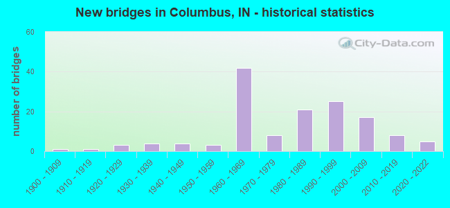
- New bridges - historical statistics
- 11900-1909
- 11910-1919
- 31920-1929
- 41930-1939
- 41940-1949
- 31950-1959
- 421960-1969
- 81970-1979
- 211980-1989
- 251990-1999
- 172000-2009
- 82010-2019
- 52020-2022
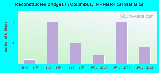
- Reconstructed bridges - Historical Statistics
- 11970-1979
- 101980-1989
- 51990-1999
- 22000-2009
- 102010-2019
- 42020-2022
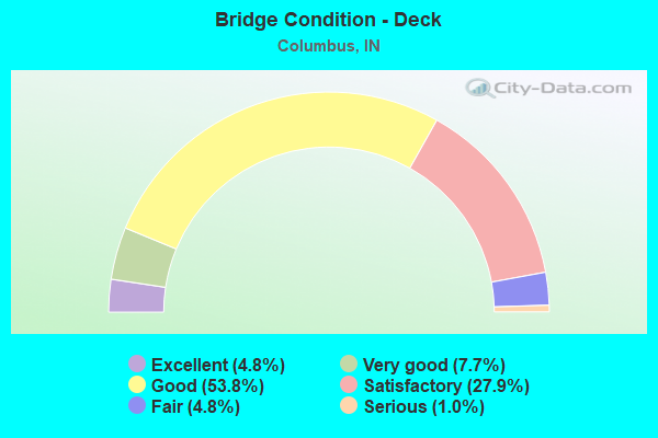
- Bridge Condition - Deck
- 4.8%Excellent
- 7.7%Very good
- 53.8%Good
- 27.9%Satisfactory
- 4.8%Fair
- 1.0%Serious
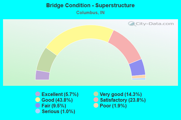
- Bridge Condition - Superstructure
- 5.7%Excellent
- 14.3%Very good
- 43.8%Good
- 23.8%Satisfactory
- 9.5%Fair
- 1.9%Poor
- 1.0%Serious
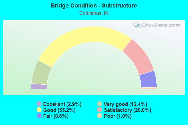
- Bridge Condition - Substructure
- 2.9%Excellent
- 12.4%Very good
- 55.2%Good
- 20.0%Satisfactory
- 8.6%Fair
- 1.0%Poor
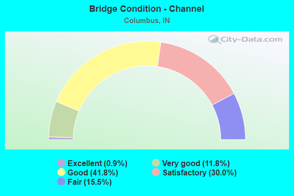
- Bridge Condition - Channel
- 0.9%Excellent
- 11.8%Very good
- 41.8%Good
- 30.0%Satisfactory
- 15.5%Fair
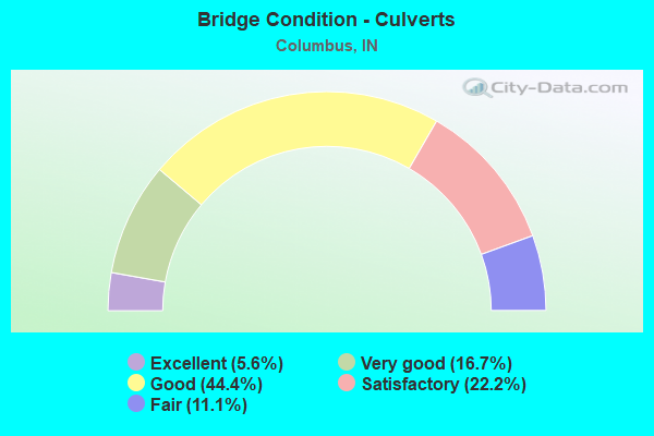
- Bridge Condition - Culverts
- 5.6%Excellent
- 16.7%Very good
- 44.4%Good
- 22.2%Satisfactory
- 11.1%Fair
Find on map >> Show street view
Structure Number: 300165, Location: 00.37 E OF CR 250 W (Lat: 39.097561, Lng: -85.950225), Route carried "on" structure: Alternate County highway 10, Year Built: 1905, Status: Posted for load-capacity, Structure Length: 1.65m (5.41ft), Average Daily Traffic: 10 (year 2018), Truck Traffic: 5%, Average Future Daily Traffic: 20 (year 2038), Features Intersected: EAST FORK WHITE CREEK, Facility Carried by Structure: CR 700S
Minimum Vertical Clearance: 30+ m (98+ ft), Kilometerpoint: 0.000, Lanes on structure: 1, Owner: County Highway Agency, Approaching Roadway Width: 2.7m (8.9ft), Material/Design: Concrete, Design/Construction: Arch - Deck, Number Of Spans In Main Unit: 1, Length of Maximum Span: 14.6m (47.9ft), Curb-To-Curb Width: 3.8m (12.5ft), Out-to-Out Width: 5.0m (16.4ft)
Condition: Superstructure: Satisfactory, Substructure: Satisfactory, Channel: Satisfactory, Operating Rating: 32.7 metric tons, Method Used To Determine Operating Rating: Field evaluation and documented engineering judgment, Inventory Rating: 32.7 metric tons, Method Used To Determine Inventory Rating: Field evaluation and documented engineering judgment, Structural Evaluation: Equal to present minimum criteria, Deck Geometry: Meets minimum limits, Waterway Adequacy: Equal to present minimum criteria, Approach Roadway Alignment: Equal to present minimum criteria, Designated Inspection Frequency: Every 24 months, Inspection Date: June 2020, Wearing Surface/Protective System: Wearing Surface: Gravel
Find on map >> Show street view
Structure Number: 300168, Location: 00.60 E OF CR 400 W (Lat: 39.112011, Lng: -85.974564), Route carried "on" structure: Alternate County highway 112, Year Built: 2004, Status: Open, Structure Length: 1.36m (4.46ft), Average Daily Traffic: 140 (year 2018), Truck Traffic: 2%, Average Future Daily Traffic: 240 (year 2038), Design Load: HS 20, Features Intersected: BR OF E FORK WHITE CR, Facility Carried by Structure: CR 600S
Minimum Vertical Clearance: 30+ m (98+ ft), Kilometerpoint: 0.000, Lanes on structure: 2, Owner: County Highway Agency, Approaching Roadway Width: 6.1m (20.0ft), Material/Design: Prestressed concrete, Design/Construction: Box Beam or Girders - Multiple, Number Of Spans In Main Unit: 1, Length of Maximum Span: 13.1m (43.0ft), Curb-To-Curb Width: 8.7m (28.5ft), Out-to-Out Width: 8.8m (28.9ft)
Condition: Deck: Good, Superstructure: Very good, Substructure: Very good, Channel: Good, Operating Rating: 32.7 metric tons, Method Used To Determine Operating Rating: Field evaluation and documented engineering judgment, Inventory Rating: 32.7 metric tons, Method Used To Determine Inventory Rating: Field evaluation and documented engineering judgment, Structural Evaluation: Equal to present desirable criteria, Deck Geometry: Equal to present minimum criteria, Waterway Adequacy: Better than present minimum criteria, Approach Roadway Alignment: Equal to present desirable criteria, Designated Inspection Frequency: Every 24 months, Inspection Date: June 2020, Deck Structure Type: Concrete Cast-file-Place, Wearing Surface/Protective System: Wearing Surface: Monolithic Concrete
Find on map >> Show street view
Structure Number: 300169, Location: 00.50 E OF CR 400 W (Lat: 39.112019, Lng: -85.976364), Route carried "on" structure: Alternate County highway 112, Year Built: 1988, Status: Open, Structure Length: 4.60m (15.09ft), Average Daily Traffic: 140 (year 2018), Truck Traffic: 2%, Average Future Daily Traffic: 240 (year 2038), Design Load: HS 20, Features Intersected: EAST FORK WHITE CREEK, Facility Carried by Structure: CR 600S
Minimum Vertical Clearance: 30+ m (98+ ft), Kilometerpoint: 0.000, Lanes on structure: 2, Owner: County Highway Agency, Approaching Roadway Width: 6.1m (20.0ft), Skew: 2 degrees, Material/Design: Concrete continuous, Design/Construction: Slab, Number Of Spans In Main Unit: 4, Length of Maximum Span: 11.3m (37.1ft), Curb-To-Curb Width: 8.5m (27.9ft), Out-to-Out Width: 8.5m (27.9ft)
Condition: Deck: Good, Superstructure: Good, Substructure: Good, Channel: Satisfactory, Operating Rating: 32.7 metric tons, Method Used To Determine Operating Rating: Field evaluation and documented engineering judgment, Inventory Rating: 32.7 metric tons, Method Used To Determine Inventory Rating: Field evaluation and documented engineering judgment, Structural Evaluation: Better than present minimum criteria, Deck Geometry: Equal to present minimum criteria, Waterway Adequacy: Equal to present desirable criteria, Approach Roadway Alignment: Equal to present desirable criteria, Designated Inspection Frequency: Every 24 months, Inspection Date: June 2020, Deck Structure Type: Concrete Cast-file-Place, Wearing Surface/Protective System: Wearing Surface: Monolithic Concrete
Find on map >> Show street view
Structure Number: 300171, Location: 00.18 W OF CR 400 W (Lat: 39.119069, Lng: -85.989197), Route carried "on" structure: Alternate County highway 274, Year Built: 1991, Status: Open, Structure Length: 2.23m (7.32ft), Average Daily Traffic: 190 (year 2018), Truck Traffic: 5%, Average Future Daily Traffic: 330 (year 2038), Design Load: HS 20, Features Intersected: BR OF E FORK WHITE CR, Facility Carried by Structure: CR 550S
Minimum Vertical Clearance: 30+ m (98+ ft), Kilometerpoint: 0.000, Lanes on structure: 2, Owner: County Highway Agency, Approaching Roadway Width: 6.1m (20.0ft), Skew: 2 degrees, Material/Design: Concrete continuous, Design/Construction: Slab, Number Of Spans In Main Unit: 3, Length of Maximum Span: 8.4m (27.6ft), Curb-To-Curb Width: 8.5m (27.9ft), Out-to-Out Width: 8.5m (27.9ft)
Condition: Deck: Good, Superstructure: Good, Substructure: Good, Channel: Good, Operating Rating: 32.7 metric tons, Method Used To Determine Operating Rating: Field evaluation and documented engineering judgment, Inventory Rating: 32.7 metric tons, Method Used To Determine Inventory Rating: Field evaluation and documented engineering judgment, Structural Evaluation: Better than present minimum criteria, Deck Geometry: Equal to present minimum criteria, Waterway Adequacy: Equal to present desirable criteria, Approach Roadway Alignment: Equal to present desirable criteria, Designated Inspection Frequency: Every 24 months, Inspection Date: June 2020, Deck Structure Type: Concrete Cast-file-Place, Wearing Surface/Protective System: Wearing Surface: Monolithic Concrete
Find on map >> Show street view
Structure Number: 300173, Location: 00.28 S OF BELLSVILLE PIK (Lat: 39.142311, Lng: -86.033447), Route carried "on" structure: Alternate County highway 77, Year Built: 2001, Status: Open, Structure Length: 1.46m (4.79ft), Average Daily Traffic: 830 (year 2018), Truck Traffic: 5%, Average Future Daily Traffic: 1,450 (year 2038), Design Load: HS 20, Features Intersected: EAST FORK WHITE CREEK, Facility Carried by Structure: CR 650W
Minimum Vertical Clearance: 30+ m (98+ ft), Kilometerpoint: 0.000, Lanes on structure: 2, Owner: County Highway Agency, Approaching Roadway Width: 6.1m (20.0ft), Skew: 3 degrees, Material/Design: Prestressed concrete, Design/Construction: Box Beam or Girders - Single/Spread, Number Of Spans In Main Unit: 1, Length of Maximum Span: 12.8m (42.0ft), Curb-To-Curb Width: 8.6m (28.2ft), Out-to-Out Width: 8.7m (28.5ft)
Condition: Deck: Good, Superstructure: Very good, Substructure: Very good, Channel: Good, Operating Rating: 51.1 metric tons, Method Used To Determine Operating Rating: Load and Resistance Factor (LRFR), Inventory Rating: 41.4 metric tons, Method Used To Determine Inventory Rating: Load and Resistance Factor (LRFR), Structural Evaluation: Equal to present desirable criteria, Deck Geometry: Somewhat better than minimum adequacy, Waterway Adequacy: Better than present minimum criteria, Approach Roadway Alignment: Equal to present minimum criteria, Designated Inspection Frequency: Every 24 months, Inspection Date: June 2020, Deck Structure Type: Concrete Cast-file-Place, Wearing Surface/Protective System: Wearing Surface: Monolithic Concrete
Find on map >> Show street view
Structure Number: 300174, Location: 00.77 W OF CR 550 W (Lat: 39.130119, Lng: -86.026658), Route carried "on" structure: Alternate County highway 14, Year Built: 1980, Status: Open, Structure Length: 0.79m (2.59ft), Average Daily Traffic: 1,440 (year 2018), Truck Traffic: 3%, Average Future Daily Traffic: 2,510 (year 2038), Design Load: HS 20, Features Intersected: EAST FORK WHITE CREEK, Facility Carried by Structure: CR 450S
Minimum Vertical Clearance: 30+ m (98+ ft), Kilometerpoint: 0.000, Lanes on structure: 2, Owner: County Highway Agency, Approaching Roadway Width: 6.7m (22.0ft), Material/Design: Prestressed concrete, Design/Construction: Box Beam or Girders - Multiple, Number Of Spans In Main Unit: 1, Length of Maximum Span: 7.9m (25.9ft), Curb-To-Curb Width: 7.9m (25.9ft), Out-to-Out Width: 8.0m (26.2ft)
Condition: Deck: Satisfactory, Superstructure: Satisfactory, Substructure: Fair, Channel: Fair, Operating Rating: 50.6 metric tons, Method Used To Determine Operating Rating: Load and Resistance Factor (LRFR), Inventory Rating: 41.9 metric tons, Method Used To Determine Inventory Rating: Load and Resistance Factor (LRFR), Structural Evaluation: Somewhat better than minimum adequacy, Deck Geometry: Meets minimum limits, Waterway Adequacy: Better than present minimum criteria, Approach Roadway Alignment: Equal to present minimum criteria, Length Of Structure Improvement: 0.79m (2.59ft), Designated Inspection Frequency: Every 24 months, Inspection Date: June 2020, Bridge Improvement Cost: $30,000, Total Project Cost: $30,000 ( Estimate for 2020), Deck Structure Type: Concrete Precast Panels, Wearing Surface/Protective System: Wearing Surface: Bituminous
Find on map >> Show street view
Structure Number: 300182, Location: 00.54 S OF CR 850 S (Lat: 39.066511, Lng: -85.984414), Route carried "on" structure: Alternate County highway 5, Year Built: 1980, Status: Open, Structure Length: 2.32m (7.61ft), Average Daily Traffic: 630 (year 2018), Truck Traffic: 3%, Average Future Daily Traffic: 1,100 (year 2038), Features Intersected: WHITE CREEK, Facility Carried by Structure: CR 400W
Minimum Vertical Clearance: 30+ m (98+ ft), Kilometerpoint: 0.000, Lanes on structure: 2, Owner: County Highway Agency, Approaching Roadway Width: 7.0m (23.0ft), Skew: 1 degrees, Material/Design: Prestressed concrete, Design/Construction: Box Beam or Girders - Multiple, Number Of Spans In Main Unit: 3, Length of Maximum Span: 8.5m (27.9ft), Curb-To-Curb Width: 7.9m (25.9ft), Out-to-Out Width: 8.0m (26.2ft)
Condition: Deck: Fair, Superstructure: Fair, Substructure: Satisfactory, Channel: Satisfactory, Operating Rating: 57.1 metric tons, Method Used To Determine Operating Rating: Load and Resistance Factor (LRFR), Inventory Rating: 39.2 metric tons, Method Used To Determine Inventory Rating: Load and Resistance Factor (LRFR), Structural Evaluation: Somewhat better than minimum adequacy, Deck Geometry: Somewhat better than minimum adequacy, Waterway Adequacy: Better than present minimum criteria, Approach Roadway Alignment: Equal to present desirable criteria, Designated Inspection Frequency: Every 24 months, Inspection Date: June 2020, Deck Structure Type: Concrete Precast Panels, Wearing Surface/Protective System: Wearing Surface: Bituminous
Find on map >> Show street view
Structure Number: 30019, Location: 00.14 NE OF SR 46 (Lat: 39.199839, Lng: -86.034019), Route carried "on" structure: Alternate County highway 260, Year Built: 2001, Status: Open, Structure Length: 2.04m (6.69ft), Average Daily Traffic: 1,440 (year 2018), Truck Traffic: 3%, Average Future Daily Traffic: 2,510 (year 2038), Design Load: HS 20, Features Intersected: WOLF CREEK, Facility Carried by Structure: CR 25N
Minimum Vertical Clearance: 30+ m (98+ ft), Kilometerpoint: 0.000, Lanes on structure: 2, Owner: County Highway Agency, Approaching Roadway Width: 5.8m (19.0ft), Skew: 4 degrees, Material/Design: Prestressed concrete continuous, Design/Construction: Box Beam or Girders - Multiple, Number Of Spans In Main Unit: 1, Length of Maximum Span: 19.1m (62.7ft), Curb-To-Curb Width: 7.3m (24.0ft), Out-to-Out Width: 7.3m (24.0ft)
Condition: Deck: Good, Superstructure: Good, Substructure: Good, Channel: Good, Operating Rating: 65.9 metric tons, Method Used To Determine Operating Rating: Load and Resistance Factor (LRFR), Inventory Rating: 54.6 metric tons, Method Used To Determine Inventory Rating: Load and Resistance Factor (LRFR), Structural Evaluation: Better than present minimum criteria, Deck Geometry: Meets minimum limits, Waterway Adequacy: Better than present minimum criteria, Approach Roadway Alignment: Equal to present desirable criteria, Designated Inspection Frequency: Every 24 months, Inspection Date: June 2020, Deck Structure Type: Concrete Precast Panels, Wearing Surface/Protective System: Wearing Surface: Bituminous
Find on map >> Show street view
Structure Number: 300191, Location: 01.02 E OF CR 250 W (Lat: 39.083450, Lng: -85.938142), Route carried "on" structure: Alternate County highway 180, Year Built: 1978, Status: Open, Structure Length: 1.46m (4.79ft), Average Daily Traffic: 10 (year 2018), Truck Traffic: 2%, Average Future Daily Traffic: 20 (year 2038), Features Intersected: EAST FORK WHITE CREEK, Facility Carried by Structure: CR 800S
Minimum Vertical Clearance: 30+ m (98+ ft), Kilometerpoint: 0.000, Lanes on structure: 2, Owner: County Highway Agency, Approaching Roadway Width: 4.0m (13.1ft), Material/Design: Prestressed concrete, Design/Construction: Box Beam or Girders - Multiple, Number Of Spans In Main Unit: 1, Length of Maximum Span: 13.8m (45.3ft), Curb or Sidewalk Widths: Left: 0.3m (1.0ft), Right: 0.3m (1.0ft), Curb-To-Curb Width: 4.9m (16.1ft), Out-to-Out Width: 5.5m (18.0ft)
Condition: Deck: Satisfactory, Superstructure: Satisfactory, Substructure: Satisfactory, Channel: Satisfactory, Operating Rating: 54.1 metric tons, Method Used To Determine Operating Rating: Load and Resistance Factor (LRFR), Inventory Rating: 33.1 metric tons, Method Used To Determine Inventory Rating: Load and Resistance Factor (LRFR), Structural Evaluation: Equal to present minimum criteria, Deck Geometry: High priority of corrective action, Waterway Adequacy: Somewhat better than minimum adequacy, Approach Roadway Alignment: Equal to present minimum criteria, Designated Inspection Frequency: Every 24 months, Inspection Date: June 2020, Deck Structure Type: Concrete Precast Panels, Wearing Surface/Protective System: Wearing Surface: Integral Concrete
Find on map >> Show street view
Structure Number: 300194, Location: 00.21 SW OF CR 650 W (Lat: 39.144519, Lng: -86.036572), Route carried "on" structure: Alternate County highway 24, Year Built: 1995, Status: Open, Structure Length: 0.73m (2.40ft), Average Daily Traffic: 1,690 (year 2018), Truck Traffic: 5%, Average Future Daily Traffic: 2,940 (year 2038), Design Load: HS 20, Features Intersected: EAST FORK WHITE CREEK, Facility Carried by Structure: BELLEVILLE RD
Minimum Vertical Clearance: 30+ m (98+ ft), Kilometerpoint: 0.000, Lanes on structure: 2, Owner: County Highway Agency, Approaching Roadway Width: 6.1m (20.0ft), Skew: 3 degrees, Material/Design: Aluminum, Iron, Design/Construction: Culvert, Number Of Spans In Main Unit: 2, Length of Maximum Span: 3.4m (11.2ft), Curb-To-Curb Width: 6.7m (22.0ft), Out-to-Out Width: 6.7m (22.0ft)
Condition: Channel: Good, Culverts: Good, Operating Rating: 32.7 metric tons, Method Used To Determine Operating Rating: Field evaluation and documented engineering judgment, Inventory Rating: 32.7 metric tons, Method Used To Determine Inventory Rating: Field evaluation and documented engineering judgment, Structural Evaluation: Better than present minimum criteria, Deck Geometry: High priority of corrective action, Waterway Adequacy: Better than present minimum criteria, Approach Roadway Alignment: Equal to present minimum criteria, Designated Inspection Frequency: Every 24 months, Inspection Date: June 2020
Find on map >> Show street view
Structure Number: 300201, Location: 00.03 E OF SR 11 (Lat: 39.142889, Lng: -85.911775), Route carried "on" structure: Alternate City street 138, Year Built: 1974, Status: Open, Structure Length: 0.88m (2.89ft), Average Daily Traffic: 110 (year 2018), Truck Traffic: 2%, Average Future Daily Traffic: 190 (year 2038), Design Load: HS 20, Features Intersected: DENIOS CREEK, Facility Carried by Structure: CR 400S
Minimum Vertical Clearance: 30+ m (98+ ft), Kilometerpoint: 0.000, Lanes on structure: 1, Owner: County Highway Agency, Approaching Roadway Width: 4.3m (14.1ft), Skew: 2 degrees, Material/Design: Steel, Design/Construction: Culvert, Number Of Spans In Main Unit: 3, Length of Maximum Span: 2.7m (8.9ft), Curb-To-Curb Width: 4.3m (14.1ft), Out-to-Out Width: 4.3m (14.1ft)
Condition: Channel: Fair, Culverts: Fair, Operating Rating: 32.7 metric tons, Method Used To Determine Operating Rating: Field evaluation and documented engineering judgment, Inventory Rating: 32.7 metric tons, Method Used To Determine Inventory Rating: Field evaluation and documented engineering judgment, Structural Evaluation: Somewhat better than minimum adequacy, Deck Geometry: High priority of replacement, Waterway Adequacy: Meets minimum limits, Approach Roadway Alignment: High priority of corrective action, Length Of Structure Improvement: 1.59m (5.22ft), Designated Inspection Frequency: Every 24 months, Inspection Date: June 2020, Bridge Improvement Cost: $210,000, Roadway Improvement Cost: $467,000, Total Project Cost: $855,000 ( Estimate for 2020)
Find on map >> Show street view
Structure Number: 300202, Location: 00.85 S OF CR 200 S (Lat: 39.161519, Lng: -85.958739), Route carried "on" structure: Alternate County highway 24, Year Built: 1960, Status: Open, Structure Length: 2.83m (9.28ft), Average Daily Traffic: 580 (year 2018), Truck Traffic: 5%, Average Future Daily Traffic: 1,010 (year 2038), Features Intersected: DENIOS CREEK, Facility Carried by Structure: CR 260W
Minimum Vertical Clearance: 30+ m (98+ ft), Kilometerpoint: 0.000, Lanes on structure: 2, Owner: County Highway Agency, Approaching Roadway Width: 5.5m (18.0ft), Material/Design: Concrete continuous, Design/Construction: Slab, Number Of Spans In Main Unit: 3, Length of Maximum Span: 11.2m (36.7ft), Curb or Sidewalk Widths: Left: 0.4m (1.3ft), Right: 0.4m (1.3ft), Curb-To-Curb Width: 6.1m (20.0ft), Out-to-Out Width: 7.7m (25.3ft)
Condition: Deck: Satisfactory, Superstructure: Good, Substructure: Good, Channel: Satisfactory, Operating Rating: 32.7 metric tons, Method Used To Determine Operating Rating: Field evaluation and documented engineering judgment, Inventory Rating: 32.7 metric tons, Method Used To Determine Inventory Rating: Field evaluation and documented engineering judgment, Structural Evaluation: Better than present minimum criteria, Deck Geometry: High priority of corrective action, Waterway Adequacy: Better than present minimum criteria, Approach Roadway Alignment: Equal to present minimum criteria, Designated Inspection Frequency: Every 24 months, Inspection Date: June 2020, Deck Structure Type: Concrete Cast-file-Place, Wearing Surface/Protective System: Wearing Surface: Monolithic Concrete
Find on map >> Show street view
Structure Number: 300204, Location: 00.08 W OF MARR RD (Lat: 39.237850, Lng: -85.885414), Route carried "on" structure: City street 46, Year Built: 1968, Status: Open, Structure Length: 7.10m (23.29ft), Average Daily Traffic: 12,810 (year 2018), Truck Traffic: 10%, Average Future Daily Traffic: 22,300 (year 2038), Design Load: HS 20, Features Intersected: HAW CREEK, Facility Carried by Structure: ROCKY FORD RD
Minimum Vertical Clearance: 30+ m (98+ ft), Kilometerpoint: 0.000, Lanes on structure: 4, Owner: County Highway Agency, Approaching Roadway Width: 11.0m (36.1ft), Skew: 2 degrees, Material/Design: Prestressed concrete, Design/Construction: Stringer/Multi-beam, Number Of Spans In Main Unit: 3, Length of Maximum Span: 24.7m (81.0ft), Curb or Sidewalk Widths: Left: 2.3m (7.5ft), Right: 2.3m (7.5ft), Curb-To-Curb Width: 15.2m (49.9ft), Out-to-Out Width: 21.0m (68.9ft)
Condition: Deck: Good, Superstructure: Good, Substructure: Good, Channel: Satisfactory, Operating Rating: 65.6 metric tons, Method Used To Determine Operating Rating: Load and Resistance Factor (LRFR), Inventory Rating: 52.6 metric tons, Method Used To Determine Inventory Rating: Load and Resistance Factor (LRFR), Structural Evaluation: Better than present minimum criteria, Deck Geometry: High priority of corrective action, Waterway Adequacy: Better than present minimum criteria, Approach Roadway Alignment: Equal to present minimum criteria, Designated Inspection Frequency: Every 24 months, Inspection Date: June 2020, Deck Structure Type: Concrete Cast-file-Place, Wearing Surface/Protective System: Wearing Surface: Monolithic Concrete
Find on map >> Show street view
Structure Number: 300205, Location: 00.29 W OF CR 400 W (Lat: 39.118881, Lng: -85.991258), Route carried "on" structure: Alternate County highway 274, Year Built: 1987, Status: Open, Structure Length: 1.25m (4.10ft), Average Daily Traffic: 190 (year 2018), Truck Traffic: 5%, Average Future Daily Traffic: 330 (year 2038), Design Load: HS 20, Features Intersected: EAST FORK WHITE CREEK, Facility Carried by Structure: CR 550S
Minimum Vertical Clearance: 30+ m (98+ ft), Kilometerpoint: 0.000, Lanes on structure: 2, Owner: County Highway Agency, Approaching Roadway Width: 6.7m (22.0ft), Skew: 1 degrees, Material/Design: Prestressed concrete, Design/Construction: Box Beam or Girders - Multiple, Number Of Spans In Main Unit: 1, Length of Maximum Span: 12.2m (40.0ft), Curb-To-Curb Width: 8.5m (27.9ft), Out-to-Out Width: 8.5m (27.9ft)
Condition: Deck: Good, Superstructure: Good, Substructure: Good, Channel: Good, Operating Rating: 47.9 metric tons, Method Used To Determine Operating Rating: Load and Resistance Factor (LRFR), Inventory Rating: 37.6 metric tons, Method Used To Determine Inventory Rating: Load and Resistance Factor (LRFR), Structural Evaluation: Better than present minimum criteria, Deck Geometry: Equal to present minimum criteria, Waterway Adequacy: Equal to present minimum criteria, Approach Roadway Alignment: Equal to present desirable criteria, Designated Inspection Frequency: Every 24 months, Inspection Date: June 2020, Deck Structure Type: Concrete Precast Panels, Wearing Surface/Protective System: Wearing Surface: Bituminous
Find on map >> Show street view
Structure Number: 300206, Location: 00.28 E OF CENTRAL AVE (Lat: 39.208139, Lng: -85.899100), Route carried "on" structure: City street , Year Built: 1978, Status: Open, Structure Length: 8.17m (26.80ft), Average Daily Traffic: 17,300 (year 2018), Truck Traffic: 10%, Average Future Daily Traffic: 30,120 (year 2038), Design Load: HS 20, Features Intersected: HAW CREEK, Facility Carried by Structure: 8TH ST (EAST)
Minimum Vertical Clearance: 30+ m (98+ ft), Kilometerpoint: 0.000, Lanes on structure: 2, Owner: County Highway Agency, Approaching Roadway Width: 8.1m (26.6ft), Skew: 4 degrees, Material/Design: Prestressed concrete continuous, Design/Construction: Stringer/Multi-beam, Number Of Spans In Main Unit: 3, Length of Maximum Span: 26.7m (87.6ft), Curb or Sidewalk Widths: Left: 0.3m (1.0ft), Right: 1.2m (3.9ft), Curb-To-Curb Width: 8.1m (26.6ft), Out-to-Out Width: 10.3m (33.8ft)
Condition: Deck: Satisfactory, Superstructure: Fair, Substructure: Satisfactory, Channel: Satisfactory, Operating Rating: 61.9 metric tons, Method Used To Determine Operating Rating: Load and Resistance Factor (LRFR), Inventory Rating: 50.8 metric tons, Method Used To Determine Inventory Rating: Load and Resistance Factor (LRFR), Structural Evaluation: Somewhat better than minimum adequacy, Deck Geometry: High priority of replacement, Waterway Adequacy: Equal to present minimum criteria, Approach Roadway Alignment: Equal to present minimum criteria, Designated Inspection Frequency: Every 24 months, Inspection Date: June 2020, Deck Structure Type: Concrete Cast-file-Place, Wearing Surface/Protective System: Wearing Surface: Bituminous
Find on map >> Show street view
Structure Number: 300207, Location: 00.03 E OF CENTRAL AVE (Lat: 39.206039, Lng: -85.903983), Route carried "on" structure: Alternate City street , Year Built: 2000, Status: Open, Structure Length: 4.60m (15.09ft), Average Daily Traffic: 10,210 (year 2018), Truck Traffic: 10%, Average Future Daily Traffic: 17,780 (year 2038), Design Load: HS 20, Features Intersected: HAW CREEK, Facility Carried by Structure: 7TH ST
Minimum Vertical Clearance: 30+ m (98+ ft), Kilometerpoint: 0.000, Lanes on structure: 4, Owner: County Highway Agency, Approaching Roadway Width: 14.0m (45.9ft), Material/Design: Prestressed concrete continuous, Design/Construction: Box Beam or Girders - Single/Spread, Number Of Spans In Main Unit: 3, Length of Maximum Span: 15.5m (50.9ft), Curb or Sidewalk Widths: Left: 2.0m (6.6ft), Right: 2.0m (6.6ft), Curb-To-Curb Width: 14.0m (45.9ft), Out-to-Out Width: 18.2m (59.7ft)
Condition: Deck: Good, Superstructure: Good, Substructure: Good, Channel: Good, Operating Rating: 32.7 metric tons, Method Used To Determine Operating Rating: Field evaluation and documented engineering judgment, Inventory Rating: 32.7 metric tons, Method Used To Determine Inventory Rating: Field evaluation and documented engineering judgment, Structural Evaluation: Better than present minimum criteria, Deck Geometry: High priority of replacement, Waterway Adequacy: Equal to present desirable criteria, Approach Roadway Alignment: Equal to present minimum criteria, Designated Inspection Frequency: Every 24 months, Inspection Date: June 2020, Deck Structure Type: Concrete Cast-file-Place, Wearing Surface/Protective System: Wearing Surface: Monolithic Concrete, Deck Protection: Epoxy Coated Reinforcing
Find on map >> Show street view
Structure Number: 300208, Location: 00.35 E OF CENTRAL AVE (Lat: 39.215850, Lng: -85.897697), Route carried "on" structure: City street , Year Built: 1968, Year Reconstructed: 2010, Status: Open, Structure Length: 6.40m (21.00ft), Average Daily Traffic: 23,860 (year 2018), Truck Traffic: 10%, Average Future Daily Traffic: 41,540 (year 2038), Features Intersected: HAW CREEK, Facility Carried by Structure: 17TH ST
Minimum Vertical Clearance: 30+ m (98+ ft), Kilometerpoint: 0.000, Lanes on structure: 4, Owner: County Highway Agency, Approaching Roadway Width: 16.5m (54.1ft), Skew: 1 degrees, Material/Design: Prestressed concrete, Design/Construction: Stringer/Multi-beam, Number Of Spans In Main Unit: 3, Length of Maximum Span: 24.1m (79.1ft), Curb or Sidewalk Widths: Left: 1.4m (4.6ft), Right: 1.4m (4.6ft), Curb-To-Curb Width: 16.5m (54.1ft), Out-to-Out Width: 20.3m (66.6ft)
Condition: Deck: Good, Superstructure: Good, Substructure: Good, Channel: Good, Operating Rating: 75.3 metric tons, Method Used To Determine Operating Rating: Load and Resistance Factor (LRFR), Inventory Rating: 59.4 metric tons, Method Used To Determine Inventory Rating: Load and Resistance Factor (LRFR), Structural Evaluation: Better than present minimum criteria, Deck Geometry: Meets minimum limits, Waterway Adequacy: Equal to present desirable criteria, Approach Roadway Alignment: Equal to present minimum criteria, Designated Inspection Frequency: Every 24 months, Inspection Date: June 2020, Deck Structure Type: Concrete Cast-file-Place, Wearing Surface/Protective System: Wearing Surface: Monolithic Concrete
Find on map >> Show street view
Structure Number: 300211, Location: 01.26 E OF CR 500 W (Lat: 39.228581, Lng: -85.983575), Route carried "on" structure: Alternate County highway 176, Year Built: 1977, Status: Open, Structure Length: 1.13m (3.71ft), Average Daily Traffic: 300 (year 2018), Truck Traffic: 5%, Average Future Daily Traffic: 520 (year 2038), Design Load: HS 20, Features Intersected: BRANCH OF CATHERINE CR, Facility Carried by Structure: CR 200N
Minimum Vertical Clearance: 30+ m (98+ ft), Kilometerpoint: 0.000, Lanes on structure: 2, Owner: County Highway Agency, Approaching Roadway Width: 6.1m (20.0ft), Skew: 1 degrees, Material/Design: Prestressed concrete, Design/Construction: Box Beam or Girders - Multiple, Number Of Spans In Main Unit: 1, Length of Maximum Span: 10.1m (33.1ft), Curb-To-Curb Width: 8.5m (27.9ft), Out-to-Out Width: 8.6m (28.2ft)
Condition: Deck: Good, Superstructure: Good, Substructure: Good, Channel: Satisfactory, Operating Rating: 42.3 metric tons, Method Used To Determine Operating Rating: Load and Resistance Factor (LRFR), Inventory Rating: 34.6 metric tons, Method Used To Determine Inventory Rating: Load and Resistance Factor (LRFR), Structural Evaluation: Better than present minimum criteria, Deck Geometry: Equal to present minimum criteria, Waterway Adequacy: Better than present minimum criteria, Approach Roadway Alignment: Equal to present minimum criteria, Designated Inspection Frequency: Every 24 months, Inspection Date: May 2020, Deck Structure Type: Concrete Precast Panels, Wearing Surface/Protective System: Wearing Surface: Bituminous
Find on map >> Show street view
Structure Number: 30022, Location: 00.53 N OF CR 300 S (Lat: 39.163550, Lng: -85.986500), Route carried "on" structure: Alternate County highway 5, Year Built: 1960, Status: Posted for load, Structure Length: 2.38m (7.81ft), Average Daily Traffic: 2,850 (year 2018), Truck Traffic: 5%, Average Future Daily Traffic: 4,960 (year 2038), Features Intersected: DENIOS CREEK, Facility Carried by Structure: CR 400W
Minimum Vertical Clearance: 30+ m (98+ ft), Kilometerpoint: 0.000, Lanes on structure: 2, Owner: County Highway Agency, Approaching Roadway Width: 6.1m (20.0ft), Material/Design: Concrete, Design/Construction: Channel Beam, Number Of Spans In Main Unit: 3, Length of Maximum Span: 7.9m (25.9ft), Curb or Sidewalk Widths: Left: 0.3m (1.0ft), Right: 0.3m (1.0ft), Curb-To-Curb Width: 7.5m (24.6ft), Out-to-Out Width: 8.1m (26.6ft)
Condition: Deck: Serious, Superstructure: Serious, Substructure: Satisfactory, Channel: Fair, Operating Rating: 25.4 metric tons, Method Used To Determine Operating Rating: Field evaluation and documented engineering judgment, Inventory Rating: 25.4 metric tons, Method Used To Determine Inventory Rating: Field evaluation and documented engineering judgment, Structural Evaluation: High priority of corrective action, Deck Geometry: High priority of replacement, Waterway Adequacy: Equal to present minimum criteria, Approach Roadway Alignment: Equal to present minimum criteria, Bridge Posting: Required (Relationship of Operating Rating to Maximum Legal Load: 20.0 - 29.9% below), Length Of Structure Improvement: 4.75m (15.58ft), Designated Inspection Frequency: Every 12 months, Inspection Date: May 2021, Bridge Improvement Cost: $497,000, Roadway Improvement Cost: $184,000, Total Project Cost: $860,000 ( Estimate for 2020), Deck Structure Type: Concrete Cast-file-Place, Wearing Surface/Protective System: Wearing Surface: Bituminous
Find on map >> Show street view
Structure Number: 300221, Location: 00.71 W OF SR 11 (Lat: 39.171250, Lng: -85.943108), Route carried "on" structure: City street 320, Year Built: 1992, Status: Open, Structure Length: 1.46m (4.79ft), Average Daily Traffic: 1,690 (year 2018), Truck Traffic: 5%, Average Future Daily Traffic: 2,940 (year 2038), Design Load: HS 20, Features Intersected: OPOSSUM CREEK, Facility Carried by Structure: CR 200S
Minimum Vertical Clearance: 30+ m (98+ ft), Kilometerpoint: 0.000, Lanes on structure: 2, Owner: County Highway Agency, Approaching Roadway Width: 7.3m (24.0ft), Skew: 4 degrees, Material/Design: Wood or Timber, Design/Construction: Slab, Number Of Spans In Main Unit: 3, Length of Maximum Span: 4.8m (15.7ft), Curb or Sidewalk Widths: Left: 0.2m (0.7ft), Right: 0.2m (0.7ft), Curb-To-Curb Width: 8.6m (28.2ft), Out-to-Out Width: 9.0m (29.5ft)
Condition: Deck: Good, Superstructure: Good, Substructure: Good, Channel: Good, Inventory Rating: 81.4 metric tons, Method Used To Determine Inventory Rating: Load and Resistance Factor (LRFR), Structural Evaluation: Better than present minimum criteria, Deck Geometry: Somewhat better than minimum adequacy, Waterway Adequacy: Equal to present desirable criteria, Approach Roadway Alignment: Equal to present desirable criteria, Designated Inspection Frequency: Every 24 months, Inspection Date: June 2020, Deck Structure Type: Wood or Timber, Wearing Surface/Protective System: Wearing Surface: Bituminous
Find on map >> Show street view
Structure Number: 300224, Location: 00.12 S OF CR 700 E AND (Lat: 39.237911, Lng: -85.785308), Route carried "on" structure: Alternate County highway 182, Year Built: 1989, Status: Open, Structure Length: 0.67m (2.20ft), Average Daily Traffic: 140 (year 2018), Truck Traffic: 2%, Average Future Daily Traffic: 240 (year 2038), Design Load: HS 20, Features Intersected: BRANCH OF CLIFTY CREEK, Facility Carried by Structure: CR 670E
Minimum Vertical Clearance: 30+ m (98+ ft), Kilometerpoint: 0.000, Lanes on structure: 2, Owner: County Highway Agency, Approaching Roadway Width: 4.6m (15.1ft), Skew: 1 degrees, Material/Design: Aluminum, Iron, Design/Construction: Culvert, Number Of Spans In Main Unit: 1, Length of Maximum Span: 6.6m (21.7ft), Curb-To-Curb Width: 4.9m (16.1ft), Out-to-Out Width: 4.9m (16.1ft)
Condition: Channel: Satisfactory, Culverts: Good, Operating Rating: 32.7 metric tons, Method Used To Determine Operating Rating: Field evaluation and documented engineering judgment, Inventory Rating: 32.7 metric tons, Method Used To Determine Inventory Rating: Field evaluation and documented engineering judgment, Structural Evaluation: Better than present minimum criteria, Waterway Adequacy: Equal to present minimum criteria, Approach Roadway Alignment: Equal to present minimum criteria, Designated Inspection Frequency: Every 24 months, Inspection Date: May 2020
Find on map >> Show street view
Structure Number: 300225, Location: 00.36 S OF GOELLER BLVD (Lat: 39.187989, Lng: -85.976844), Route carried "on" structure: Alternate City street , Year Built: 1982, Status: Open, Structure Length: 6.49m (21.29ft), Average Daily Traffic: 200 (year 2018), Truck Traffic: 5%, Average Future Daily Traffic: 350 (year 2038), Design Load: HS 20, Features Intersected: TIPTON LAKES CANAL, Facility Carried by Structure: TIPTON LAKES BLVD
Minimum Vertical Clearance: 30+ m (98+ ft), Kilometerpoint: 0.000, Lanes on structure: 4, Owner: County Highway Agency, Approaching Roadway Width: 16.8m (55.1ft), Skew: 20 degrees, Material/Design: Concrete, Design/Construction: Culvert, Number Of Spans In Main Unit: 1, Length of Maximum Span: 23.8m (78.1ft), Curb or Sidewalk Widths: Left: 2.3m (7.5ft), Right: 2.3m (7.5ft), Curb-To-Curb Width: 15.9m (52.2ft), Out-to-Out Width: 15.9m (52.2ft)
Condition: Channel: Very good, Culverts: Good, Operating Rating: 32.7 metric tons, Method Used To Determine Operating Rating: Field evaluation and documented engineering judgment, Inventory Rating: 32.7 metric tons, Method Used To Determine Inventory Rating: Field evaluation and documented engineering judgment, Structural Evaluation: Better than present minimum criteria, Deck Geometry: Meets minimum limits, Waterway Adequacy: Equal to present desirable criteria, Approach Roadway Alignment: Equal to present desirable criteria, Designated Inspection Frequency: Every 24 months, Inspection Date: June 2020, Wearing Surface/Protective System: Wearing Surface: Bituminous
Find on map >> Show street view
Structure Number: 300227, Location: 02.81 E US 31 (Lat: 39.281700, Lng: -85.906844), Route carried "on" structure: County highway 52, Year Built: 1985, Status: Open, Structure Length: 2.01m (6.59ft), Average Daily Traffic: 5,520 (year 2018), Truck Traffic: 5%, Average Future Daily Traffic: 9,610 (year 2038), Design Load: HS 20, Features Intersected: FLATROCK RIVER OVERFLOW, Facility Carried by Structure: CR 550N
Minimum Vertical Clearance: 30+ m (98+ ft), Kilometerpoint: 0.000, Lanes on structure: 2, Owner: County Highway Agency, Approaching Roadway Width: 7.3m (24.0ft), Skew: 1 degrees, Material/Design: Prestressed concrete continuous, Design/Construction: Stringer/Multi-beam, Number Of Spans In Main Unit: 1, Length of Maximum Span: 19.8m (65.0ft), Curb-To-Curb Width: 9.8m (32.2ft), Out-to-Out Width: 10.5m (34.4ft)
Condition: Deck: Very good, Superstructure: Very good, Substructure: Good, Channel: Good, Operating Rating: 32.7 metric tons, Method Used To Determine Operating Rating: Field evaluation and documented engineering judgment, Inventory Rating: 32.7 metric tons, Method Used To Determine Inventory Rating: Field evaluation and documented engineering judgment, Structural Evaluation: Better than present minimum criteria, Deck Geometry: Meets minimum limits, Waterway Adequacy: Equal to present desirable criteria, Approach Roadway Alignment: Equal to present desirable criteria, Designated Inspection Frequency: Every 24 months, Inspection Date: May 2020, Deck Structure Type: Concrete Cast-file-Place, Wearing Surface/Protective System: Wearing Surface: Monolithic Concrete
Find on map >> Show street view
Structure Number: 300229, Location: 00.21 SE OF 8TH STREET (Lat: 39.206319, Lng: -85.929192), Route carried "on" structure: Alternate City street , Year Built: 1986, Year Reconstructed: 1991, Status: Posted for load-capacity, Structure Length: 2.93m (9.61ft), Average Daily Traffic: 350 (year 2018), Truck Traffic: 5%, Average Future Daily Traffic: 610 (year 2038), Features Intersected: BRANCH DRIFTWOOD RIVER, Facility Carried by Structure: PARK RD
Minimum Vertical Clearance: 4.72m (15.49ft), Kilometerpoint: 0.000, Lanes on structure: 1, Owner: City or Municipal Highway Agency, Approaching Roadway Width: 6.7m (22.0ft), Material/Design: Wood or Timber, Design/Construction: Truss - Thru, Number Of Spans In Main Unit: 1, Length of Maximum Span: 27.3m (89.6ft), Curb-To-Curb Width: 4.6m (15.1ft), Out-to-Out Width: 6.5m (21.3ft)
Condition: Deck: Satisfactory, Superstructure: Satisfactory, Substructure: Satisfactory, Channel: Very good, Operating Rating: 32.7 metric tons, Method Used To Determine Operating Rating: Field evaluation and documented engineering judgment, Inventory Rating: 32.7 metric tons, Method Used To Determine Inventory Rating: Field evaluation and documented engineering judgment, Structural Evaluation: Equal to present minimum criteria, Deck Geometry: High priority of replacement, Waterway Adequacy: Equal to present desirable criteria, Approach Roadway Alignment: Equal to present minimum criteria, Length Of Structure Improvement: 2.93m (9.61ft), Designated Inspection Frequency: Every 24 months, Inspection Date: June 2020, Bridge Improvement Cost: $219,000, Roadway Improvement Cost: $184,000, Total Project Cost: $488,000 ( Estimate for 2020), Deck Structure Type: Wood or Timber, Wearing Surface/Protective System: Wearing Surface: Wood or Timber
Find on map >> Show street view
Structure Number: 30023, Location: 00.37 W OF CR 700 W (Lat: 39.209750, Lng: -86.049286), Route carried "on" structure: County highway 172, Year Built: 2003, Status: Open, Structure Length: 0.73m (2.40ft), Average Daily Traffic: 330 (year 2018), Truck Traffic: 5%, Average Future Daily Traffic: 570 (year 2038), Design Load: HS 20, Features Intersected: NORTH BRANCH WOLF CREEK, Facility Carried by Structure: BAKER HOLLOW RD
Minimum Vertical Clearance: 30+ m (98+ ft), Kilometerpoint: 0.000, Lanes on structure: 2, Owner: County Highway Agency, Approaching Roadway Width: 6.1m (20.0ft), Skew: 3 degrees, Material/Design: Wood or Timber, Design/Construction: Slab, Number Of Spans In Main Unit: 1, Length of Maximum Span: 6.7m (22.0ft), Curb or Sidewalk Widths: Left: 0.2m (0.7ft), Right: 0.2m (0.7ft), Curb-To-Curb Width: 9.2m (30.2ft), Out-to-Out Width: 9.6m (31.5ft)
Condition: Deck: Good, Superstructure: Good, Substructure: Good, Channel: Good, Inventory Rating: 76.3 metric tons, Method Used To Determine Inventory Rating: Load and Resistance Factor (LRFR), Structural Evaluation: Better than present minimum criteria, Deck Geometry: Equal to present minimum criteria, Waterway Adequacy: Better than present minimum criteria, Approach Roadway Alignment: Equal to present minimum criteria, Designated Inspection Frequency: Every 24 months, Inspection Date: June 2020, Deck Structure Type: Wood or Timber, Wearing Surface/Protective System: Wearing Surface: Bituminous
Find on map >> Show street view
Structure Number: 300305, Location: 00.80 E OF SR 11 (Lat: 39.138539, Lng: -85.893853), Route carried "on" structure: County highway 126, Year Built: 1994, Status: Open, Structure Length: 48.77m (160.01ft), Average Daily Traffic: 3,980 (year 2018), Truck Traffic: 5%, Average Future Daily Traffic: 6,930 (year 2038), Design Load: HS 20, Features Intersected: EAST FORK WHITE RIVER, Facility Carried by Structure: CR 450S
Minimum Vertical Clearance: 30+ m (98+ ft), Kilometerpoint: 0.000, Lanes on structure: 2, Owner: County Highway Agency, Approaching Roadway Width: 9.8m (32.2ft), Material/Design: Prestressed concrete continuous, Design/Construction: Tee Beam, Number Of Spans In Main Unit: 15, Length of Maximum Span: 32.5m (106.6ft), Curb-To-Curb Width: 9.8m (32.2ft), Out-to-Out Width: 10.7m (35.1ft)
Condition: Deck: Good, Superstructure: Fair, Substructure: Good, Channel: Satisfactory, Operating Rating: 68.4 metric tons, Method Used To Determine Operating Rating: Load and Resistance Factor (LRFR), Inventory Rating: 46.4 metric tons, Method Used To Determine Inventory Rating: Load and Resistance Factor (LRFR), Structural Evaluation: Somewhat better than minimum adequacy, Deck Geometry: Meets minimum limits, Waterway Adequacy: Equal to present desirable criteria, Approach Roadway Alignment: Equal to present desirable criteria, Designated Inspection Frequency: Every 24 months, Inspection Date: June 2020, Deck Structure Type: Concrete Cast-file-Place, Wearing Surface/Protective System: Wearing Surface: Monolithic Concrete
Find on map >> Show street view
Structure Number: 300306, Location: 01.08 E SR 11 (Lat: 39.140600, Lng: -85.889611), Route carried "on" structure: County highway 126, Year Built: 1994, Status: Open, Structure Length: 13.17m (43.21ft), Average Daily Traffic: 3,980 (year 2018), Truck Traffic: 5%, Average Future Daily Traffic: 6,930 (year 2038), Design Load: HS 20, Features Intersected: OVERFLOW-E FK WHITE R, Facility Carried by Structure: CR 450S
Minimum Vertical Clearance: 30+ m (98+ ft), Kilometerpoint: 0.000, Lanes on structure: 2, Owner: County Highway Agency, Approaching Roadway Width: 8.5m (27.9ft), Material/Design: Prestressed concrete continuous, Design/Construction: Tee Beam, Number Of Spans In Main Unit: 4, Length of Maximum Span: 32.8m (107.6ft), Curb-To-Curb Width: 9.8m (32.2ft), Out-to-Out Width: 10.7m (35.1ft)
Condition: Deck: Good, Superstructure: Fair, Substructure: Good, Channel: Good, Operating Rating: 32.7 metric tons, Method Used To Determine Operating Rating: Field evaluation and documented engineering judgment, Inventory Rating: 32.7 metric tons, Method Used To Determine Inventory Rating: Field evaluation and documented engineering judgment, Structural Evaluation: Somewhat better than minimum adequacy, Deck Geometry: Meets minimum limits, Waterway Adequacy: Equal to present desirable criteria, Approach Roadway Alignment: Equal to present desirable criteria, Designated Inspection Frequency: Every 24 months, Inspection Date: June 2020, Deck Structure Type: Concrete Cast-file-Place, Wearing Surface/Protective System: Wearing Surface: Monolithic Concrete
Find on map >> Show street view
Structure Number: 30031, Location: 00.10 E OF HAWCREEK AVE (Lat: 39.216839, Lng: -85.897278), Route carried "on" structure: City street , Year Built: 1993, Status: Open, Structure Length: 3.66m (12.01ft), Average Daily Traffic: 1,750 (year 2018), Truck Traffic: 5%, Average Future Daily Traffic: 3,050 (year 2038), Design Load: HS 20, Features Intersected: HAW CREEK, Facility Carried by Structure: 18TH ST
Minimum Vertical Clearance: 30+ m (98+ ft), Kilometerpoint: 0.000, Lanes on structure: 3, Owner: County Highway Agency, Approaching Roadway Width: 11.9m (39.0ft), Skew: 1 degrees, Material/Design: Concrete continuous, Design/Construction: Slab, Number Of Spans In Main Unit: 3, Length of Maximum Span: 14.2m (46.6ft), Curb or Sidewalk Widths: Left: 1.5m (4.9ft), Right: 1.5m (4.9ft), Curb-To-Curb Width: 11.9m (39.0ft), Out-to-Out Width: 16.5m (54.1ft)
Condition: Deck: Satisfactory, Superstructure: Good, Substructure: Good, Channel: Good, Operating Rating: 32.7 metric tons, Method Used To Determine Operating Rating: Field evaluation and documented engineering judgment, Inventory Rating: 32.7 metric tons, Method Used To Determine Inventory Rating: Field evaluation and documented engineering judgment, Structural Evaluation: Better than present minimum criteria, Deck Geometry: High priority of corrective action, Waterway Adequacy: Better than present minimum criteria, Approach Roadway Alignment: Equal to present minimum criteria, Designated Inspection Frequency: Every 24 months, Inspection Date: June 2020, Deck Structure Type: Concrete Cast-file-Place, Wearing Surface/Protective System: Wearing Surface: Monolithic Concrete
Find on map >> Show street view
Structure Number: 300311, Location: 00.12 S OF CR 300 N (Lat: 39.245519, Lng: -85.782172), Route carried "on" structure: Alternate County highway 41, Year Built: 1994, Status: Open, Structure Length: 0.67m (2.20ft), Average Daily Traffic: 80 (year 2018), Truck Traffic: 3%, Average Future Daily Traffic: 140 (year 2038), Design Load: HS 20, Features Intersected: BRANCH OF CLIFTY CREEK, Facility Carried by Structure: CR 700E
Minimum Vertical Clearance: 30+ m (98+ ft), Kilometerpoint: 0.000, Lanes on structure: 2, Owner: County Highway Agency, Approaching Roadway Width: 4.9m (16.1ft), Skew: 3 degrees, Material/Design: Aluminum, Iron, Design/Construction: Culvert, Number Of Spans In Main Unit: 1, Length of Maximum Span: 6.6m (21.7ft), Curb-To-Curb Width: 5.0m (16.4ft), Out-to-Out Width: 5.0m (16.4ft)
Condition: Channel: Satisfactory, Culverts: Satisfactory, Operating Rating: 32.7 metric tons, Method Used To Determine Operating Rating: Field evaluation and documented engineering judgment, Inventory Rating: 32.7 metric tons, Method Used To Determine Inventory Rating: Field evaluation and documented engineering judgment, Structural Evaluation: Equal to present minimum criteria, Deck Geometry: High priority of corrective action, Waterway Adequacy: Equal to present minimum criteria, Approach Roadway Alignment: Equal to present minimum criteria, Designated Inspection Frequency: Every 24 months, Inspection Date: May 2020
Find on map >> Show street view
Structure Number: 300315, Location: 00.27 S OF YOUTH CAMP RD (Lat: 39.184250, Lng: -85.989625), Route carried "on" structure: City street , Year Built: 2000, Status: Open, Structure Length: 4.72m (15.49ft), Average Daily Traffic: 200 (year 2018), Truck Traffic: 5%, Average Future Daily Traffic: 350 (year 2038), Design Load: HS 20, Features Intersected: TIPTON LAKES CANAL, Facility Carried by Structure: TIPTON LAKES BLVD
Minimum Vertical Clearance: 30+ m (98+ ft), Kilometerpoint: 0.000, Lanes on structure: 4, Owner: County Highway Agency, Approaching Roadway Width: 16.8m (55.1ft), Skew: 30 degrees, Material/Design: Concrete continuous, Design/Construction: Box Beam or Girders - Multiple, Number Of Spans In Main Unit: 3, Length of Maximum Span: 22.9m (75.1ft), Curb or Sidewalk Widths: Left: 2.3m (7.5ft), Right: 2.3m (7.5ft), Curb-To-Curb Width: 16.5m (54.1ft), Out-to-Out Width: 21.6m (70.9ft)
Condition: Deck: Good, Superstructure: Good, Substructure: Good, Channel: Very good, Operating Rating: 32.7 metric tons, Method Used To Determine Operating Rating: Field evaluation and documented engineering judgment, Inventory Rating: 32.7 metric tons, Method Used To Determine Inventory Rating: Field evaluation and documented engineering judgment, Structural Evaluation: Better than present minimum criteria, Deck Geometry: Meets minimum limits, Waterway Adequacy: Equal to present desirable criteria, Approach Roadway Alignment: Equal to present minimum criteria, Designated Inspection Frequency: Every 24 months, Inspection Date: June 2020, Deck Structure Type: Concrete Cast-file-Place, Wearing Surface/Protective System: Wearing Surface: Monolithic Concrete, Deck Protection: Epoxy Coated Reinforcing
Find on map >> Show street view
Structure Number: 300316, Location: 00.31 E OF CR 500 E (Lat: 39.224511, Lng: -85.814139), Route carried "on" structure: County highway , Year Built: 1930, Status: Open, Structure Length: 0.85m (2.79ft), Average Daily Traffic: 7,190 (year 2018), Truck Traffic: 5%, Average Future Daily Traffic: 12,520 (year 2038), Design Load: HS 20, Features Intersected: BRANCH OF CLIFTY CREEK, Facility Carried by Structure: 25TH ST
Minimum Vertical Clearance: 30+ m (98+ ft), Kilometerpoint: 0.000, Lanes on structure: 2, Owner: County Highway Agency, Approaching Roadway Width: 10.1m (33.1ft), Skew: 4 degrees, Material/Design: Concrete, Design/Construction: Slab, Number Of Spans In Main Unit: 1, Length of Maximum Span: 7.5m (24.6ft), Curb-To-Curb Width: 11.2m (36.7ft), Out-to-Out Width: 11.9m (39.0ft)
Condition: Deck: Good, Superstructure: Good, Substructure: Good, Channel: Fair, Operating Rating: 32.7 metric tons, Method Used To Determine Operating Rating: Field evaluation and documented engineering judgment, Inventory Rating: 32.7 metric tons, Method Used To Determine Inventory Rating: Field evaluation and documented engineering judgment, Structural Evaluation: Better than present minimum criteria, Deck Geometry: Meets minimum limits, Waterway Adequacy: Equal to present minimum criteria, Approach Roadway Alignment: Equal to present desirable criteria, Designated Inspection Frequency: Every 24 months, Inspection Date: May 2020, Deck Structure Type: Concrete Cast-file-Place, Wearing Surface/Protective System: Wearing Surface: Bituminous
Find on map >> Show street view
Structure Number: 300317, Location: 01.32 W SR 9 (Lat: 39.224861, Lng: -85.796264), Route carried "on" structure: County highway , Year Built: 1930, Year Reconstructed: 1993, Status: Open, Structure Length: 9.36m (30.71ft), Average Daily Traffic: 200 (year 2018), Truck Traffic: 3%, Average Future Daily Traffic: 350 (year 2038), Design Load: HS 20, Features Intersected: CLIFTY CREEK, Facility Carried by Structure: 25TH ST
Minimum Vertical Clearance: 30+ m (98+ ft), Kilometerpoint: 0.000, Lanes on structure: 2, Owner: County Highway Agency, Approaching Roadway Width: 13.4m (44.0ft), Material/Design: Prestressed concrete continuous, Design/Construction: Box Beam or Girders - Multiple, Number Of Spans In Main Unit: 4, Number Of Approach Spans: 2, Length of Maximum Span: 19.3m (63.3ft), Curb-To-Curb Width: 10.2m (33.5ft), Out-to-Out Width: 11.1m (36.4ft)
Condition: Deck: Fair, Superstructure: Satisfactory, Substructure: Fair, Channel: Satisfactory, Operating Rating: 60.3 metric tons, Method Used To Determine Operating Rating: Load and Resistance Factor (LRFR), Inventory Rating: 36.1 metric tons, Method Used To Determine Inventory Rating: Load and Resistance Factor (LRFR), Structural Evaluation: Somewhat better than minimum adequacy, Deck Geometry: Better than present minimum criteria, Waterway Adequacy: Equal to present minimum criteria, Approach Roadway Alignment: Equal to present desirable criteria, Length Of Structure Improvement: 9.36m (30.71ft), Designated Inspection Frequency: Every 24 months, Inspection Date: May 2020, Bridge Improvement Cost: $917,000, Roadway Improvement Cost: $184,000, Total Project Cost: $1,333,000 ( Estimate for 2020), Deck Structure Type: Concrete Cast-file-Place, Wearing Surface/Protective System: Wearing Surface: Monolithic Concrete
Find on map >> Show street view
Structure Number: 300318, Location: 00.11 NW OF 11TH STRRET (Lat: 39.209439, Lng: -85.928275), Route carried "on" structure: City street , Year Built: 1926, Year Reconstructed: 1995, Status: Open, Structure Length: 14.39m (47.21ft), Average Daily Traffic: 160 (year 2018), Truck Traffic: 3%, Average Future Daily Traffic: 280 (year 2038), Design Load: HS 20, Features Intersected: FLATROCK RIVER, Facility Carried by Structure: INDIANAPOLIS RD
Minimum Vertical Clearance: 30+ m (98+ ft), Kilometerpoint: 0.000, Lanes on structure: 2, Owner: County Highway Agency, Approaching Roadway Width: 7.3m (24.0ft), Material/Design: Steel continuous, Design/Construction: Stringer/Multi-beam, Number Of Spans In Main Unit: 5, Number Of Approach Spans: 2, Length of Maximum Span: 26.0m (85.3ft), Curb-To-Curb Width: 13.5m (44.3ft), Out-to-Out Width: 14.2m (46.6ft)
Condition: Deck: Satisfactory, Superstructure: Satisfactory, Substructure: Satisfactory, Channel: Satisfactory, Operating Rating: 69.8 metric tons, Method Used To Determine Operating Rating: Load and Resistance Factor (LRFR), Inventory Rating: 59.6 metric tons, Method Used To Determine Inventory Rating: Load and Resistance Factor (LRFR), Structural Evaluation: Equal to present minimum criteria, Deck Geometry: Superior to present desirable criteria, Waterway Adequacy: Equal to present desirable criteria, Approach Roadway Alignment: Equal to present desirable criteria, Designated Inspection Frequency: Every 24 months, Inspection Date: June 2020, Deck Structure Type: Concrete Cast-file-Place, Wearing Surface/Protective System: Wearing Surface: Monolithic Concrete
Find on map >> Show street view
Structure Number: 300319, Location: 00.08 W OF US 31 (Lat: 39.223100, Lng: -85.892464), Route carried "on" structure: City street , Year Built: 1962, Year Reconstructed: 1990, Status: Open, Structure Length: 6.07m (19.91ft), Average Daily Traffic: 160 (year 2018), Truck Traffic: 3%, Average Future Daily Traffic: 280 (year 2038), Design Load: HS 20, Features Intersected: HAW CREEK, Facility Carried by Structure: 25TH ST
Minimum Vertical Clearance: 30+ m (98+ ft), Kilometerpoint: 0.000, Lanes on structure: 4, Owner: County Highway Agency, Approaching Roadway Width: 14.6m (47.9ft), Skew: 23 degrees, Material/Design: Prestressed concrete continuous, Design/Construction: Stringer/Multi-beam, Number Of Spans In Main Unit: 3, Length of Maximum Span: 24.5m (80.4ft), Curb or Sidewalk Widths: Left: 1.5m (4.9ft), Right: 1.5m (4.9ft), Curb-To-Curb Width: 15.5m (50.9ft), Out-to-Out Width: 24.4m (80.1ft)
Condition: Deck: Good, Superstructure: Good, Substructure: Good, Channel: Good, Operating Rating: 32.7 metric tons, Method Used To Determine Operating Rating: Field evaluation and documented engineering judgment, Inventory Rating: 32.7 metric tons, Method Used To Determine Inventory Rating: Field evaluation and documented engineering judgment, Structural Evaluation: Better than present minimum criteria, Deck Geometry: Meets minimum limits, Waterway Adequacy: Equal to present minimum criteria, Approach Roadway Alignment: Equal to present desirable criteria, Designated Inspection Frequency: Every 24 months, Inspection Date: June 2020, Deck Structure Type: Concrete Cast-file-Place, Wearing Surface/Protective System: Wearing Surface: Monolithic Concrete, Deck Protection: Epoxy Coated Reinforcing
Find on map >> Show street view
Structure Number: 30032, Location: 00.45 E OF TALLEY RD (Lat: 39.223889, Lng: -85.848969), Route carried "on" structure: City street , Year Built: 1929, Year Reconstructed: 1994, Status: Open, Structure Length: 2.59m (8.50ft), Average Daily Traffic: 160 (year 2018), Truck Traffic: 3%, Average Future Daily Traffic: 280 (year 2038), Design Load: HS 20, Features Intersected: SLOAN CREEK, Facility Carried by Structure: 25TH ST
Minimum Vertical Clearance: 30+ m (98+ ft), Kilometerpoint: 0.000, Lanes on structure: 2, Owner: County Highway Agency, Approaching Roadway Width: 9.1m (29.9ft), Skew: 2 degrees, Material/Design: Concrete continuous, Design/Construction: Slab, Number Of Spans In Main Unit: 3, Length of Maximum Span: 8.8m (28.9ft), Curb-To-Curb Width: 12.1m (39.7ft), Out-to-Out Width: 13.0m (42.7ft)
Condition: Deck: Satisfactory, Superstructure: Satisfactory, Substructure: Fair, Channel: Fair, Operating Rating: 32.7 metric tons, Method Used To Determine Operating Rating: Field evaluation and documented engineering judgment, Inventory Rating: 32.7 metric tons, Method Used To Determine Inventory Rating: Field evaluation and documented engineering judgment, Structural Evaluation: Somewhat better than minimum adequacy, Deck Geometry: Superior to present desirable criteria, Waterway Adequacy: Equal to present minimum criteria, Approach Roadway Alignment: Equal to present desirable criteria, Designated Inspection Frequency: Every 24 months, Inspection Date: May 2020, Deck Structure Type: Concrete Cast-file-Place, Wearing Surface/Protective System: Wearing Surface: Monolithic Concrete
Find on map >> Show street view
Structure Number: 300322, Location: 00.36 S OF CR 300 N (Lat: 39.242069, Lng: -85.782700), Route carried "on" structure: Alternate County highway 41, Year Built: 1994, Status: Open, Structure Length: 0.79m (2.59ft), Average Daily Traffic: 80 (year 2018), Truck Traffic: 3%, Average Future Daily Traffic: 140 (year 2038), Design Load: HS 20, Features Intersected: BRANCH OF CLIFTY CREEK, Facility Carried by Structure: CR 700E
Minimum Vertical Clearance: 30+ m (98+ ft), Kilometerpoint: 0.000, Lanes on structure: 2, Owner: County Highway Agency, Approaching Roadway Width: 4.9m (16.1ft), Skew: 4 degrees, Material/Design: Aluminum, Iron, Design/Construction: Culvert, Number Of Spans In Main Unit: 1, Length of Maximum Span: 7.8m (25.6ft), Curb-To-Curb Width: 6.1m (20.0ft), Out-to-Out Width: 6.1m (20.0ft)
Condition: Channel: Satisfactory, Culverts: Satisfactory, Operating Rating: 32.7 metric tons, Method Used To Determine Operating Rating: Field evaluation and documented engineering judgment, Inventory Rating: 32.7 metric tons, Method Used To Determine Inventory Rating: Field evaluation and documented engineering judgment, Structural Evaluation: Equal to present minimum criteria, Deck Geometry: Somewhat better than minimum adequacy, Waterway Adequacy: Equal to present minimum criteria, Approach Roadway Alignment: Equal to present minimum criteria, Designated Inspection Frequency: Every 24 months, Inspection Date: May 2020
Find on map >> Show street view
Structure Number: 300323, Location: 00.11 W OF MARR RD (Lat: 39.237819, Lng: -85.886078), Route carried "on" structure: City street 46, Year Built: 2001, Status: Open, Structure Length: 1.28m (4.20ft), Average Daily Traffic: 12,810 (year 2018), Truck Traffic: 10%, Average Future Daily Traffic: 22,300 (year 2038), Design Load: HS 20, Features Intersected: HAW CREEK, Facility Carried by Structure: ROCKY FORD RD
Minimum Vertical Clearance: 30+ m (98+ ft), Kilometerpoint: 0.000, Lanes on structure: 4, Owner: County Highway Agency, Approaching Roadway Width: 15.2m (49.9ft), Skew: 2 degrees, Material/Design: Concrete, Design/Construction: Culvert, Number Of Spans In Main Unit: 1, Length of Maximum Span: 11.0m (36.1ft), Curb or Sidewalk Widths: Left: 2.2m (7.2ft), Right: 0.0m, Curb-To-Curb Width: 15.4m (50.5ft), Out-to-Out Width: 15.4m (50.5ft)
Condition: Channel: Good, Culverts: Good, Operating Rating: 32.7 metric tons, Method Used To Determine Operating Rating: Field evaluation and documented engineering judgment, Inventory Rating: 32.7 metric tons, Method Used To Determine Inventory Rating: Field evaluation and documented engineering judgment, Structural Evaluation: Better than present minimum criteria, Deck Geometry: Meets minimum limits, Waterway Adequacy: Better than present minimum criteria, Approach Roadway Alignment: Equal to present desirable criteria, Designated Inspection Frequency: Every 24 months, Inspection Date: June 2020
Find on map >> Show street view
Structure Number: 30033, Location: 00.03 N CR 225 N (Lat: 39.237111, Lng: -85.751900), Route carried "on" structure: Alternate County highway 43, Year Built: 2015, Status: Open, Structure Length: 6.10m (20.01ft), Average Daily Traffic: 1,070 (year 2018), Truck Traffic: 5%, Average Future Daily Traffic: 1,860 (year 2038), Design Load: HS 20, Features Intersected: CLIFTY CREEK, Facility Carried by Structure: CR 850E
Minimum Vertical Clearance: 30+ m (98+ ft), Kilometerpoint: 0.000, Lanes on structure: 2, Owner: County Highway Agency, Approaching Roadway Width: 6.7m (22.0ft), Skew: 1 degrees, Material/Design: Prestressed concrete continuous, Design/Construction: Stringer/Multi-beam, Number Of Spans In Main Unit: 3, Length of Maximum Span: 22.7m (74.5ft), Curb-To-Curb Width: 9.1m (29.9ft), Out-to-Out Width: 9.3m (30.5ft)
Condition: Deck: Good, Superstructure: Very good, Substructure: Very good, Channel: Very good, Operating Rating: 32.7 metric tons, Method Used To Determine Operating Rating: Field evaluation and documented engineering judgment, Inventory Rating: 32.7 metric tons, Method Used To Determine Inventory Rating: Field evaluation and documented engineering judgment, Structural Evaluation: Equal to present desirable criteria, Deck Geometry: Somewhat better than minimum adequacy, Waterway Adequacy: Equal to present desirable criteria, Approach Roadway Alignment: Equal to present desirable criteria, Designated Inspection Frequency: Every 24 months, Inspection Date: May 2020, Deck Structure Type: Concrete Cast-file-Place, Wearing Surface/Protective System: Wearing Surface: Monolithic Concrete, Deck Protection: Epoxy Coated Reinforcing
Find on map >> Show street view
Structure Number: 300331, Location: 00.44 E OF CR 400 E (Lat: 39.187761, Lng: -85.830056), Route carried "on" structure: Alternate County highway 30, Year Built: 2014, Status: Open, Structure Length: 2.04m (6.69ft), Average Daily Traffic: 1,730 (year 2018), Truck Traffic: 3%, Average Future Daily Traffic: 3,010 (year 2038), Design Load: HS 20, Features Intersected: BRUSH CREEK, Facility Carried by Structure: CR 100S
Minimum Vertical Clearance: 30+ m (98+ ft), Kilometerpoint: 0.000, Lanes on structure: 2, Owner: County Highway Agency, Approaching Roadway Width: 6.7m (22.0ft), Material/Design: Concrete continuous, Design/Construction: Slab, Number Of Spans In Main Unit: 3, Length of Maximum Span: 7.7m (25.3ft), Curb-To-Curb Width: 9.1m (29.9ft), Out-to-Out Width: 9.3m (30.5ft)
Condition: Deck: Very good, Superstructure: Very good, Substructure: Very good, Channel: Good, Operating Rating: 32.7 metric tons, Method Used To Determine Operating Rating: Field evaluation and documented engineering judgment, Inventory Rating: 32.7 metric tons, Method Used To Determine Inventory Rating: Field evaluation and documented engineering judgment, Structural Evaluation: Equal to present desirable criteria, Deck Geometry: Somewhat better than minimum adequacy, Waterway Adequacy: Better than present minimum criteria, Approach Roadway Alignment: Equal to present minimum criteria, Designated Inspection Frequency: Every 24 months, Inspection Date: June 2020, Deck Structure Type: Concrete Cast-file-Place, Wearing Surface/Protective System: Wearing Surface: Monolithic Concrete, Deck Protection: Epoxy Coated Reinforcing
Find on map >> Show street view
Structure Number: 300332, Location: 00.82 E OF CR 400 W (Lat: 39.074961, Lng: -85.969308), Route carried "on" structure: Alternate County highway 92, Year Built: 2014, Status: Open, Structure Length: 0.61m (2.00ft), Average Daily Traffic: 140 (year 2018), Truck Traffic: 5%, Average Future Daily Traffic: 240 (year 2038), Features Intersected: BRANCH OF WHITE CREEK, Facility Carried by Structure: CR 850S
Minimum Vertical Clearance: 30+ m (98+ ft), Kilometerpoint: 0.000, Lanes on structure: 2, Owner: County Highway Agency, Approaching Roadway Width: 4.6m (15.1ft), Material/Design: Aluminum, Iron, Design/Construction: Culvert, Number Of Spans In Main Unit: 1, Length of Maximum Span: 6.1m (20.0ft), Curb-To-Curb Width: 4.9m (16.1ft), Out-to-Out Width: 4.9m (16.1ft)
Condition: Channel: Good, Culverts: Very good, Operating Rating: 32.7 metric tons, Method Used To Determine Operating Rating: Field evaluation and documented engineering judgment, Inventory Rating: 32.7 metric tons, Method Used To Determine Inventory Rating: Field evaluation and documented engineering judgment, Structural Evaluation: Equal to present desirable criteria, Waterway Adequacy: Equal to present minimum criteria, Approach Roadway Alignment: Equal to present minimum criteria, Designated Inspection Frequency: Every 24 months, Inspection Date: June 2020