Bridge Statistics for Comfort, Texas (TX)
Condition, Traffic, Stress, Structural Evaluation, Project Costs
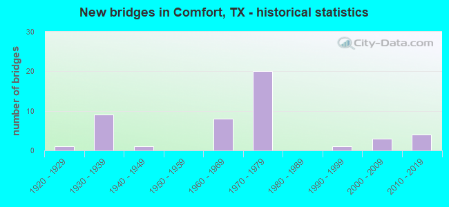
- New bridges - historical statistics
- 11920-1929
- 91930-1939
- 11940-1949
- 81960-1969
- 201970-1979
- 11990-1999
- 32000-2009
- 42010-2019

- Reconstructed bridges - Historical Statistics
- 11940-1949
- 61950-1959
- 01960-1969
- 11970-1979
- 11980-1989


- Bridge Condition - Deck
- 28.6%Very good
- 60.0%Good
- 11.4%Satisfactory

- Bridge Condition - Superstructure
- 20.0%Very good
- 62.9%Good
- 17.1%Satisfactory

- Bridge Condition - Substructure
- 5.7%Very good
- 54.3%Good
- 34.3%Satisfactory
- 5.7%Fair

- Bridge Condition - Channel
- 3.0%Very good
- 36.4%Good
- 57.6%Satisfactory
- 3.0%Poor

- Bridge Condition - Culverts
- 50.0%Good
- 50.0%Satisfactory
Find on map >> Show street view
Structure Number: 151310007202007, Location: 10.3 MI N OF IH 10 (Lat: 30.123211, Lng: -98.911719), Route carried "on" structure: US 87, Year Built: 1932, Year Reconstructed: 1961, Status: Open, Structure Length: 1.74m (5.71ft), Average Daily Traffic: 3,496 (year 2020), Truck Traffic: 12%, Average Future Daily Traffic: 5,690 (year 2033), Features Intersected: BEAR CREEK
Minimum Vertical Clearance: 30+ m (98+ ft), Kilometerpoint: 1.709, Lanes on structure: 3, Owner: State Highway Agency, Approaching Roadway Width: 15.9m (52.2ft), Material/Design: Concrete, Design/Construction: Tee Beam, Number Of Spans In Main Unit: 2, Length of Maximum Span: 8.8m (28.9ft), Curb-To-Curb Width: 15.3m (50.2ft), Out-to-Out Width: 16.5m (54.1ft)
Condition: Deck: Good, Superstructure: Good, Substructure: Good, Channel: Satisfactory, Operating Rating: 52.6 metric tons, Method Used To Determine Operating Rating: Load Factor (LF), Inventory Rating: 31.7 metric tons, Method Used To Determine Inventory Rating: Load Factor (LF), Structural Evaluation: Better than present minimum criteria, Deck Geometry: Equal to present minimum criteria, Waterway Adequacy: Equal to present minimum criteria, Approach Roadway Alignment: Equal to present desirable criteria, Designated Inspection Frequency: Every 24 months, Inspection Date: June 2020, Deck Structure Type: Concrete Cast-file-Place, Wearing Surface/Protective System: Wearing Surface: Bituminous
Find on map >> Show street view
Structure Number: 151310007204009, Location: 3.8 MI N OF IH 10 (Lat: 30.035231, Lng: -98.909456), Route carried "on" structure: US 87, Year Built: 1932, Year Reconstructed: 1961, Status: Open, Structure Length: 4.36m (14.30ft), Average Daily Traffic: 8,542 (year 2020), Truck Traffic: 12%, Average Future Daily Traffic: 5,690 (year 2033), Features Intersected: NORTH CREEK
Minimum Vertical Clearance: 30+ m (98+ ft), Kilometerpoint: 12.081, Lanes on structure: 2, Owner: State Highway Agency, Approaching Roadway Width: 13.4m (44.0ft), Material/Design: Concrete, Design/Construction: Tee Beam, Number Of Spans In Main Unit: 5, Length of Maximum Span: 8.8m (28.9ft), Curb-To-Curb Width: 13.1m (43.0ft), Out-to-Out Width: 14.3m (46.9ft)
Condition: Deck: Good, Superstructure: Good, Substructure: Satisfactory, Channel: Good, Operating Rating: 52.6 metric tons, Method Used To Determine Operating Rating: Load Factor (LF), Inventory Rating: 31.7 metric tons, Method Used To Determine Inventory Rating: Load Factor (LF), Structural Evaluation: Equal to present minimum criteria, Deck Geometry: Somewhat better than minimum adequacy, Waterway Adequacy: Equal to present minimum criteria, Approach Roadway Alignment: Equal to present desirable criteria, Designated Inspection Frequency: Every 24 months, Inspection Date: June 2020, Deck Structure Type: Concrete Cast-file-Place, Wearing Surface/Protective System: Wearing Surface: Bituminous
Find on map >> Show street view
Structure Number: 15131000720401, Location: 2.4 MI N OF IH 10 (Lat: 30.013622, Lng: -98.905456), Route carried "on" structure: US 87, Year Built: 1932, Year Reconstructed: 1961, Status: Open, Structure Length: 5.21m (17.09ft), Average Daily Traffic: 8,542 (year 2020), Truck Traffic: 12%, Average Future Daily Traffic: 5,690 (year 2033), Features Intersected: NORTH CREEK
Minimum Vertical Clearance: 30+ m (98+ ft), Kilometerpoint: 14.511, Lanes on structure: 2, Owner: State Highway Agency, Approaching Roadway Width: 14.0m (45.9ft), Material/Design: Concrete, Design/Construction: Tee Beam, Number Of Spans In Main Unit: 6, Length of Maximum Span: 8.8m (28.9ft), Curb-To-Curb Width: 13.1m (43.0ft), Out-to-Out Width: 14.3m (46.9ft)
Condition: Deck: Good, Superstructure: Good, Substructure: Satisfactory, Channel: Satisfactory, Operating Rating: 52.6 metric tons, Method Used To Determine Operating Rating: Load Factor (LF), Inventory Rating: 31.7 metric tons, Method Used To Determine Inventory Rating: Load Factor (LF), Structural Evaluation: Equal to present minimum criteria, Deck Geometry: Somewhat better than minimum adequacy, Waterway Adequacy: Equal to present minimum criteria, Approach Roadway Alignment: Equal to present desirable criteria, Designated Inspection Frequency: Every 24 months, Inspection Date: June 2020, Deck Structure Type: Concrete Cast-file-Place, Wearing Surface/Protective System: Wearing Surface: Bituminous
Find on map >> Show street view
Structure Number: 151310007204011, Location: 0.1 MI S OF FM 473 (Lat: 29.969100, Lng: -98.903706), Route carried "on" structure: Business US 87, Year Built: 1932, Year Reconstructed: 1961, Status: Open, Structure Length: 0.70m (2.30ft), Average Daily Traffic: 2,460 (year 2013), Truck Traffic: 7%, Average Future Daily Traffic: 3,450 (year 2033), Design Load: H 15, Features Intersected: DRAW
Minimum Vertical Clearance: 30+ m (98+ ft), Kilometerpoint: 19.494, Lanes on structure: 5, Owner: State Highway Agency, Approaching Roadway Width: 18.3m (60.0ft), Material/Design: Concrete, Design/Construction: Culvert, Number Of Spans In Main Unit: 4, Length of Maximum Span: 1.5m (4.9ft)
Condition: Channel: Satisfactory, Culverts: Satisfactory, Operating Rating: 32.7 metric tons, Method Used To Determine Operating Rating: Field evaluation and documented engineering judgment, Inventory Rating: 24.5 metric tons, Method Used To Determine Inventory Rating: Field evaluation and documented engineering judgment, Structural Evaluation: Equal to present minimum criteria, Waterway Adequacy: Equal to present minimum criteria, Approach Roadway Alignment: Equal to present desirable criteria, Designated Inspection Frequency: Every 24 months, Inspection Date: June 2020
Find on map >> Show street view
Structure Number: 15131000720402, Location: 0.6 MI W OF IH 10 (Lat: 29.964981, Lng: -98.896700), Route carried "on" structure: Business US 87, Year Built: 1933, Year Reconstructed: 1984, Status: Open, Structure Length: 45.54m (149.41ft), Average Daily Traffic: 5,481 (year 2020), Truck Traffic: 7%, Average Future Daily Traffic: 8,580 (year 2033), Design Load: H 15, Features Intersected: GUADALUPE RIVER
Minimum Vertical Clearance: 30+ m (98+ ft), Kilometerpoint: 20.122, Lanes on structure: 2, Owner: State Highway Agency, Approaching Roadway Width: 12.2m (40.0ft), Material/Design: Steel continuous, Design/Construction: Stringer/Multi-beam, Number Of Spans In Main Unit: 3, Number Of Approach Spans: 31, Length of Maximum Span: 61.6m (202.1ft), Curb-To-Curb Width: 13.3m (43.6ft), Out-to-Out Width: 14.0m (45.9ft)
Condition: Deck: Satisfactory, Superstructure: Satisfactory, Substructure: Satisfactory, Channel: Satisfactory, Operating Rating: 44.4 metric tons, Method Used To Determine Operating Rating: Load Factor (LF), Inventory Rating: 26.3 metric tons, Method Used To Determine Inventory Rating: Load Factor (LF), Structural Evaluation: Equal to present minimum criteria, Deck Geometry: Somewhat better than minimum adequacy, Waterway Adequacy: Superior to present desirable criteria, Approach Roadway Alignment: Equal to present desirable criteria, Designated Inspection Frequency: Every 24 months, Inspection Date: June 2020, Deck Structure Type: Concrete Cast-file-Place, Wearing Surface/Protective System: Wearing Surface: Bituminous
Find on map >> Show street view
Structure Number: 151310007205013, Location: 5.75 MI E OF KERR C/L (Lat: 29.938964, Lng: -98.870400), Route carried "on" structure: ServiceInterstate 10, Year Built: 1932, Year Reconstructed: 1955, Status: Open, Structure Length: 3.47m (11.38ft), Average Daily Traffic: 900 (year 2013), Truck Traffic: 13%, Average Future Daily Traffic: 1,260 (year 2033), Design Load: H 15, Features Intersected: HOLIDAY CREEK
Minimum Vertical Clearance: 30+ m (98+ ft), Kilometerpoint: 9.254, Lanes on structure: 2, Owner: State Highway Agency, Approaching Roadway Width: 7.3m (24.0ft), Material/Design: Concrete, Design/Construction: Tee Beam, Number Of Spans In Main Unit: 4, Length of Maximum Span: 8.5m (27.9ft), Curb-To-Curb Width: 13.2m (43.3ft), Out-to-Out Width: 14.0m (45.9ft)
Condition: Deck: Good, Superstructure: Good, Substructure: Satisfactory, Channel: Satisfactory, Operating Rating: 51.7 metric tons, Method Used To Determine Operating Rating: Load Factor (LF), Inventory Rating: 30.8 metric tons, Method Used To Determine Inventory Rating: Load Factor (LF), Structural Evaluation: Equal to present minimum criteria, Deck Geometry: Superior to present desirable criteria, Waterway Adequacy: Equal to present minimum criteria, Approach Roadway Alignment: Equal to present desirable criteria, Designated Inspection Frequency: Every 24 months, Inspection Date: June 2020, Deck Structure Type: Concrete Cast-file-Place, Wearing Surface/Protective System: Wearing Surface: Bituminous
Find on map >> Show street view
Structure Number: 151310007205173, Location: 2.98 MI E OF KERR C/L (Lat: 29.969636, Lng: -98.892519), Route carried "on" structure: Interstate 10, Year Built: 1971, Status: Open, Structure Length: 76.81m (252.00ft), Average Daily Traffic: 8,500 (year 2013), Truck Traffic: 10%, Average Future Daily Traffic: 11,900 (year 2033), Design Load: HS 20, Features Intersected: GUAD RIV/FM 473/FM 1621
Minimum Vertical Clearance: 30+ m (98+ ft), Kilometerpoint: 4.801, Lanes on structure: 2, Lanes under structure: 6, Owner: State Highway Agency, Approaching Roadway Width: 11.6m (38.1ft), Skew: 9 degrees, Material/Design: Steel continuous, Design/Construction: Stringer/Multi-beam, Number Of Spans In Main Unit: 4, Number Of Approach Spans: 30, Length of Maximum Span: 45.7m (149.9ft), Curb-To-Curb Width: 12.2m (40.0ft), Out-to-Out Width: 12.9m (42.3ft)
Condition: Deck: Satisfactory, Superstructure: Good, Substructure: Satisfactory, Channel: Satisfactory, Operating Rating: 56.2 metric tons, Method Used To Determine Operating Rating: Load Factor (LF), Inventory Rating: 33.6 metric tons, Method Used To Determine Inventory Rating: Load Factor (LF), Structural Evaluation: Equal to present minimum criteria, Deck Geometry: Better than present minimum criteria, Underclear: Equal to present minimum criteria, Waterway Adequacy: Superior to present desirable criteria, Approach Roadway Alignment: Equal to present desirable criteria, Designated Inspection Frequency: Every 24 months, Inspection Date: June 2020, Deck Structure Type: Concrete Cast-file-Place, Wearing Surface/Protective System: Wearing Surface: Bituminous
Find on map >> Show street view
Structure Number: 151310007205174, Location: 1.0 MI SE OF US 87 (Lat: 29.969603, Lng: -98.892619), Route carried "on" structure: Interstate 10, Year Built: 1971, Status: Open, Structure Length: 78.03m (256.00ft), Average Daily Traffic: 8,500 (year 2013), Truck Traffic: 10%, Average Future Daily Traffic: 11,900 (year 2033), Design Load: HS 20, Features Intersected: GUAD RIV/FM 473/FM 1621
Minimum Vertical Clearance: 30+ m (98+ ft), Kilometerpoint: 4.794, Lanes on structure: 2, Lanes under structure: 6, Owner: State Highway Agency, Approaching Roadway Width: 11.6m (38.1ft), Skew: 9 degrees, Material/Design: Steel continuous, Design/Construction: Stringer/Multi-beam, Number Of Spans In Main Unit: 4, Number Of Approach Spans: 30, Length of Maximum Span: 45.7m (149.9ft), Curb-To-Curb Width: 12.2m (40.0ft), Out-to-Out Width: 12.9m (42.3ft)
Condition: Deck: Satisfactory, Superstructure: Good, Substructure: Satisfactory, Channel: Satisfactory, Operating Rating: 56.2 metric tons, Method Used To Determine Operating Rating: Load Factor (LF), Inventory Rating: 33.6 metric tons, Method Used To Determine Inventory Rating: Load Factor (LF), Structural Evaluation: Equal to present minimum criteria, Deck Geometry: Better than present minimum criteria, Underclear: Equal to present minimum criteria, Waterway Adequacy: Superior to present desirable criteria, Approach Roadway Alignment: Equal to present desirable criteria, Designated Inspection Frequency: Every 24 months, Inspection Date: June 2020, Deck Structure Type: Concrete Cast-file-Place, Wearing Surface/Protective System: Wearing Surface: Bituminous
Find on map >> Show street view
Structure Number: 151310007205175, Location: 0.8 MI N OF FM 1621 (Lat: 29.960758, Lng: -98.888697), Route carried "on" structure: Business US 87, Year Built: 1971, Status: Open, Structure Length: 11.58m (37.99ft), Average Daily Traffic: 5,481 (year 2020), Truck Traffic: 11%, Average Future Daily Traffic: 9,470 (year 2030), Design Load: HS 20, Features Intersected: IH 10
Minimum Vertical Clearance: 30+ m (98+ ft), Kilometerpoint: 21.187, Lanes on structure: 1, Lanes under structure: 4, Owner: State Highway Agency, Approaching Roadway Width: 7.3m (24.0ft), Skew: 4 degrees, Material/Design: Steel continuous, Design/Construction: Stringer/Multi-beam, Number Of Spans In Main Unit: 2, Number Of Approach Spans: 2, Length of Maximum Span: 39.6m (129.9ft), Curb-To-Curb Width: 7.3m (24.0ft), Out-to-Out Width: 8.0m (26.2ft)
Condition: Deck: Good, Superstructure: Satisfactory, Substructure: Good, Operating Rating: 46.3 metric tons, Method Used To Determine Operating Rating: Load Factor (LF), Inventory Rating: 27.2 metric tons, Method Used To Determine Inventory Rating: Load Factor (LF), Structural Evaluation: Equal to present minimum criteria, Deck Geometry: High priority of replacement, Underclear: Somewhat better than minimum adequacy, Approach Roadway Alignment: Equal to present desirable criteria, Designated Inspection Frequency: Every 24 months, Inspection Date: June 2020, Deck Structure Type: Concrete Cast-file-Place, Wearing Surface/Protective System: Wearing Surface: Bituminous
Find on map >> Show street view
Structure Number: 151310007205176, Location: 1.1 MI SE OF FM 1621 (Lat: 29.939442, Lng: -98.869792), Route carried "on" structure: ServiceInterstate 10, Year Built: 1971, Status: Open, Structure Length: 5.03m (16.50ft), Average Daily Traffic: 70 (year 2013), Truck Traffic: 14%, Average Future Daily Traffic: 100 (year 2033), Design Load: H 15, Features Intersected: HOLIDAY CREEK
Minimum Vertical Clearance: 30+ m (98+ ft), Kilometerpoint: 9.186, Lanes on structure: 2, Owner: State Highway Agency, Approaching Roadway Width: 6.1m (20.0ft), Skew: 4 degrees, Material/Design: Prestressed concrete, Design/Construction: Stringer/Multi-beam, Number Of Spans In Main Unit: 2, Number Of Approach Spans: 1, Length of Maximum Span: 19.8m (65.0ft), Curb-To-Curb Width: 7.9m (25.9ft), Out-to-Out Width: 8.6m (28.2ft)
Condition: Deck: Very good, Superstructure: Good, Substructure: Good, Channel: Good, Operating Rating: 40.8 metric tons, Method Used To Determine Operating Rating: Load Factor (LF), Inventory Rating: 19.0 metric tons, Method Used To Determine Inventory Rating: Load Factor (LF), Structural Evaluation: Somewhat better than minimum adequacy, Deck Geometry: Equal to present minimum criteria, Waterway Adequacy: Equal to present minimum criteria, Approach Roadway Alignment: Equal to present desirable criteria, Length Of Structure Improvement: 5.03m (16.50ft), Designated Inspection Frequency: Every 24 months, Inspection Date: June 2020, Bridge Improvement Cost: $9,000, Roadway Improvement Cost: $2,000, Total Project Cost: $11,000, Deck Structure Type: Concrete Cast-file-Place, Wearing Surface/Protective System: Wearing Surface: Bituminous
Find on map >> Show street view
Structure Number: 151310007205177, Location: 1.1 MI SE OF FM 1621 (Lat: 29.939178, Lng: -98.870144), Route carried "on" structure: Interstate 10, Year Built: 1971, Status: Open, Structure Length: 5.64m (18.50ft), Average Daily Traffic: 9,780 (year 2013), Truck Traffic: 10%, Average Future Daily Traffic: 13,690 (year 2033), Design Load: HS 20, Features Intersected: HOLIDAY CREEK
Minimum Vertical Clearance: 30+ m (98+ ft), Kilometerpoint: 9.222, Lanes on structure: 2, Owner: State Highway Agency, Approaching Roadway Width: 11.6m (38.1ft), Skew: 4 degrees, Material/Design: Prestressed concrete, Design/Construction: Stringer/Multi-beam, Number Of Spans In Main Unit: 3, Length of Maximum Span: 19.8m (65.0ft), Curb-To-Curb Width: 12.2m (40.0ft), Out-to-Out Width: 12.9m (42.3ft)
Condition: Deck: Very good, Superstructure: Good, Substructure: Good, Channel: Satisfactory, Operating Rating: 63.5 metric tons, Method Used To Determine Operating Rating: Load Factor (LF), Inventory Rating: 25.4 metric tons, Method Used To Determine Inventory Rating: Load Factor (LF), Structural Evaluation: Equal to present minimum criteria, Deck Geometry: Better than present minimum criteria, Waterway Adequacy: Equal to present minimum criteria, Approach Roadway Alignment: Equal to present desirable criteria, Designated Inspection Frequency: Every 24 months, Inspection Date: June 2020, Deck Structure Type: Concrete Cast-file-Place, Wearing Surface/Protective System: Wearing Surface: Bituminous
Find on map >> Show street view
Structure Number: 151310007205178, Location: 1.1 MI SE OF FM 1621 (Lat: 29.939242, Lng: -98.870064), Route carried "on" structure: Interstate 10, Year Built: 1971, Status: Open, Structure Length: 5.03m (16.50ft), Average Daily Traffic: 9,780 (year 2013), Truck Traffic: 10%, Average Future Daily Traffic: 13,690 (year 2033), Design Load: HS 20, Features Intersected: HOLIDAY CREEK
Minimum Vertical Clearance: 30+ m (98+ ft), Kilometerpoint: 9.246, Lanes on structure: 2, Owner: State Highway Agency, Approaching Roadway Width: 11.6m (38.1ft), Skew: 1 degrees, Material/Design: Prestressed concrete, Design/Construction: Stringer/Multi-beam, Number Of Spans In Main Unit: 2, Number Of Approach Spans: 1, Length of Maximum Span: 19.8m (65.0ft), Curb-To-Curb Width: 12.2m (40.0ft), Out-to-Out Width: 12.9m (42.3ft)
Condition: Deck: Very good, Superstructure: Good, Substructure: Good, Channel: Satisfactory, Operating Rating: 63.5 metric tons, Method Used To Determine Operating Rating: Load Factor (LF), Inventory Rating: 25.4 metric tons, Method Used To Determine Inventory Rating: Load Factor (LF), Structural Evaluation: Equal to present minimum criteria, Deck Geometry: Better than present minimum criteria, Waterway Adequacy: Equal to present minimum criteria, Approach Roadway Alignment: Equal to present desirable criteria, Designated Inspection Frequency: Every 24 months, Inspection Date: June 2020, Deck Structure Type: Concrete Cast-file-Place, Wearing Surface/Protective System: Wearing Surface: Bituminous
Find on map >> Show street view
Structure Number: 151310007205179, Location: 6.1 MI SE OF KERR CO LN (Lat: 29.934914, Lng: -98.866250), Route carried "on" structure: State highway 289, Year Built: 1971, Status: Open, Structure Length: 8.35m (27.40ft), Average Daily Traffic: 700 (year 2013), Truck Traffic: 6%, Average Future Daily Traffic: 990 (year 2033), Design Load: H 15, Features Intersected: IH 10
Minimum Vertical Clearance: 30+ m (98+ ft), Kilometerpoint: 0.829, Lanes on structure: 2, Lanes under structure: 4, Owner: State Highway Agency, Approaching Roadway Width: 6.7m (22.0ft), Material/Design: Prestressed concrete, Design/Construction: Stringer/Multi-beam, Number Of Spans In Main Unit: 2, Number Of Approach Spans: 2, Length of Maximum Span: 28.0m (91.9ft), Curb-To-Curb Width: 7.9m (25.9ft), Out-to-Out Width: 8.6m (28.2ft)
Condition: Deck: Very good, Superstructure: Good, Substructure: Good, Operating Rating: 52.6 metric tons, Method Used To Determine Operating Rating: Load Factor (LF), Inventory Rating: 20.0 metric tons, Method Used To Determine Inventory Rating: Load Factor (LF), Structural Evaluation: Somewhat better than minimum adequacy, Deck Geometry: Somewhat better than minimum adequacy, Underclear: Somewhat better than minimum adequacy, Approach Roadway Alignment: Equal to present desirable criteria, Designated Inspection Frequency: Every 24 months, Inspection Date: June 2020, Deck Structure Type: Concrete Cast-file-Place, Wearing Surface/Protective System: Wearing Surface: Bituminous
Find on map >> Show street view
Structure Number: 151310014206029, Location: 0.5 MI S OF FM 473 (Lat: 29.965408, Lng: -98.915575), Route carried "on" structure: State highway 27, Year Built: 1932, Year Reconstructed: 1955, Status: Open, Structure Length: 9.54m (31.30ft), Average Daily Traffic: 6,228 (year 2020), Truck Traffic: 13%, Average Future Daily Traffic: 8,500 (year 2033), Design Load: H 15, Features Intersected: CYPRESS CREEK
Minimum Vertical Clearance: 30+ m (98+ ft), Kilometerpoint: 0.682, Lanes on structure: 4, Owner: State Highway Agency, Approaching Roadway Width: 14.0m (45.9ft), Material/Design: Concrete, Design/Construction: Tee Beam, Number Of Spans In Main Unit: 11, Length of Maximum Span: 8.8m (28.9ft), Curb or Sidewalk Widths: Left: 1.2m (3.9ft), Right: 0.0m, Curb-To-Curb Width: 13.4m (44.0ft), Out-to-Out Width: 15.3m (50.2ft)
Condition: Deck: Good, Superstructure: Good, Substructure: Satisfactory, Channel: Good, Operating Rating: 53.5 metric tons, Method Used To Determine Operating Rating: Load Factor (LF), Inventory Rating: 31.7 metric tons, Method Used To Determine Inventory Rating: Load Factor (LF), Structural Evaluation: Equal to present minimum criteria, Deck Geometry: High priority of replacement, Waterway Adequacy: Equal to present minimum criteria, Approach Roadway Alignment: Equal to present desirable criteria, Length Of Structure Improvement: 9.54m (31.30ft), Designated Inspection Frequency: Every 24 months, Inspection Date: June 2020, Bridge Improvement Cost: $28,000, Roadway Improvement Cost: $7,000, Total Project Cost: $35,000, Deck Structure Type: Concrete Cast-file-Place, Wearing Surface/Protective System: Wearing Surface: Bituminous
Find on map >> Show street view
Structure Number: 151310014209149, Location: 1.5 MI E OF US 87 (Lat: 29.971525, Lng: -98.879033), Route carried "on" structure: State highway 473, Year Built: 1972, Status: Open, Structure Length: 3.05m (10.01ft), Average Daily Traffic: 1,519 (year 2020), Truck Traffic: 19%, Average Future Daily Traffic: 1,970 (year 2033), Design Load: HS 20, Features Intersected: FLAT ROCK CREEK
Minimum Vertical Clearance: 30+ m (98+ ft), Kilometerpoint: 4.683, Lanes on structure: 2, Owner: State Highway Agency, Approaching Roadway Width: 7.3m (24.0ft), Skew: 2 degrees, Material/Design: Prestressed concrete, Design/Construction: Stringer/Multi-beam, Number Of Spans In Main Unit: 2, Length of Maximum Span: 15.2m (49.9ft), Curb-To-Curb Width: 10.4m (34.1ft), Out-to-Out Width: 11.1m (36.4ft)
Condition: Deck: Very good, Superstructure: Very good, Substructure: Good, Channel: Good, Operating Rating: 54.4 metric tons, Method Used To Determine Operating Rating: Assigned rating based on Load Factor Design (LFD) reported in metric tons, Inventory Rating: 32.7 metric tons, Method Used To Determine Inventory Rating: Assigned rating based on Load Factor Design (LFD) reported in metric tons, Structural Evaluation: Better than present minimum criteria, Deck Geometry: Equal to present minimum criteria, Waterway Adequacy: Equal to present minimum criteria, Approach Roadway Alignment: Equal to present desirable criteria, Designated Inspection Frequency: Every 24 months, Inspection Date: June 2020, Deck Structure Type: Concrete Cast-file-Place, Wearing Surface/Protective System: Wearing Surface: Bituminous
Find on map >> Show street view
Structure Number: 151310014209189, Location: 7.1 MI W OF RM 1376 (Lat: 29.998131, Lng: -98.836294), Route carried "on" structure: State highway 473, Year Built: 2009, Status: Open, Structure Length: 3.05m (10.01ft), Average Daily Traffic: 713 (year 2020), Truck Traffic: 3%, Average Future Daily Traffic: 960 (year 2028), Design Load: HL 93, Features Intersected: BLOCK CREEK
Minimum Vertical Clearance: 30+ m (98+ ft), Kilometerpoint: 9.996, Lanes on structure: 2, Owner: State Highway Agency, Approaching Roadway Width: 6.1m (20.0ft), Skew: 3 degrees, Material/Design: Prestressed concrete, Number Of Spans In Main Unit: 3, Length of Maximum Span: 12.2m (40.0ft), Curb-To-Curb Width: 9.1m (29.9ft), Out-to-Out Width: 9.8m (32.2ft)
Condition: Deck: Good, Superstructure: Good, Substructure: Very good, Channel: Good, Operating Rating: 54.4 metric tons, Method Used To Determine Operating Rating: Assigned ratings based on Load and Resistance Factor Design (LRFD) reported in metric tons, Inventory Rating: 32.7 metric tons, Method Used To Determine Inventory Rating: Assigned ratings based on Load and Resistance Factor Design (LRFD) reported in metric tons, Structural Evaluation: Better than present minimum criteria, Deck Geometry: Equal to present minimum criteria, Waterway Adequacy: Meets minimum limits, Approach Roadway Alignment: Equal to present desirable criteria, Designated Inspection Frequency: Every 24 months, Inspection Date: June 2020, Deck Structure Type: Concrete Cast-file-Place
Find on map >> Show street view
Structure Number: 151310014215072, Location: 0.35 MI E OF KERR CO LN (Lat: 29.984858, Lng: -98.915481), Route carried "on" structure: County highway 143, Year Built: 1968, Status: Open, Structure Length: 7.01m (23.00ft), Average Daily Traffic: 410 (year 2010), Average Future Daily Traffic: 20 (year 2030), Design Load: H 15, Features Intersected: IH 10, Facility Carried by Structure: NORTH CREEK RD
Minimum Vertical Clearance: 30+ m (98+ ft), Kilometerpoint: 0.805, Lanes on structure: 2, Lanes under structure: 4, Owner: State Highway Agency, Approaching Roadway Width: 6.7m (22.0ft), Material/Design: Prestressed concrete, Design/Construction: Stringer/Multi-beam, Number Of Spans In Main Unit: 2, Number Of Approach Spans: 2, Length of Maximum Span: 24.4m (80.1ft), Curb-To-Curb Width: 7.9m (25.9ft), Out-to-Out Width: 8.6m (28.2ft)
Condition: Deck: Good, Superstructure: Good, Substructure: Good, Operating Rating: 62.6 metric tons, Method Used To Determine Operating Rating: Load Factor (LF), Inventory Rating: 21.8 metric tons, Method Used To Determine Inventory Rating: Load Factor (LF), Structural Evaluation: Equal to present minimum criteria, Deck Geometry: Somewhat better than minimum adequacy, Underclear: High priority of corrective action, Approach Roadway Alignment: Equal to present desirable criteria, Designated Inspection Frequency: Every 24 months, Inspection Date: June 2020, Deck Structure Type: Concrete Cast-file-Place, Wearing Surface/Protective System: Wearing Surface: Bituminous
Find on map >> Show street view
Structure Number: 151310014215073, Location: 0.56 MI E OF KERR CO LN (Lat: 29.983547, Lng: -98.912297), Route carried "on" structure: Interstate 10, Year Built: 1968, Status: Open, Structure Length: 1.13m (3.71ft), Average Daily Traffic: 16,870 (year 2013), Truck Traffic: 16%, Average Future Daily Traffic: 23,610 (year 2033), Design Load: HS 20, Features Intersected: DRAW
Minimum Vertical Clearance: 30+ m (98+ ft), Kilometerpoint: 0.861, Lanes on structure: 8, Owner: State Highway Agency, Approaching Roadway Width: 35.4m (116.1ft), Skew: 2 degrees, Material/Design: Concrete, Design/Construction: Culvert, Number Of Spans In Main Unit: 4, Length of Maximum Span: 2.4m (7.9ft), Curb or Sidewalk Widths: Left: 0.0m, Right: 1.8m (5.9ft)
Condition: Channel: Good, Culverts: Satisfactory, Operating Rating: 39.9 metric tons, Method Used To Determine Operating Rating: Load Factor (LF), Inventory Rating: 23.6 metric tons, Method Used To Determine Inventory Rating: Load Factor (LF), Structural Evaluation: Somewhat better than minimum adequacy, Waterway Adequacy: Equal to present minimum criteria, Approach Roadway Alignment: Equal to present desirable criteria, Designated Inspection Frequency: Every 24 months, Inspection Date: June 2020
Find on map >> Show street view
Structure Number: 151310014215186, Location: 1.1 MI E OF KERR CO LN (Lat: 29.980206, Lng: -98.904014), Route carried "on" structure: Interstate 10, Year Built: 1968, Status: Open, Structure Length: 7.62m (25.00ft), Average Daily Traffic: 8,430 (year 2013), Truck Traffic: 16%, Average Future Daily Traffic: 11,800 (year 2033), Design Load: HS 20, Features Intersected: US 87
Minimum Vertical Clearance: 30+ m (98+ ft), Kilometerpoint: 1.717, Lanes on structure: 2, Lanes under structure: 6, Owner: State Highway Agency, Approaching Roadway Width: 11.6m (38.1ft), Skew: 2 degrees, Material/Design: Steel continuous, Design/Construction: Stringer/Multi-beam, Number Of Spans In Main Unit: 2, Number Of Approach Spans: 2, Length of Maximum Span: 24.4m (80.1ft), Curb-To-Curb Width: 12.2m (40.0ft), Out-to-Out Width: 12.9m (42.3ft)
Condition: Deck: Good, Superstructure: Satisfactory, Substructure: Good, Operating Rating: 49.0 metric tons, Method Used To Determine Operating Rating: Assigned rating based on Load Factor Design (LFD) reported in metric tons, Inventory Rating: 29.0 metric tons, Method Used To Determine Inventory Rating: Assigned rating based on Load Factor Design (LFD) reported in metric tons, Structural Evaluation: Equal to present minimum criteria, Deck Geometry: Better than present minimum criteria, Underclear: Equal to present minimum criteria, Approach Roadway Alignment: Equal to present desirable criteria, Designated Inspection Frequency: Every 24 months, Inspection Date: June 2020, Deck Structure Type: Concrete Cast-file-Place, Wearing Surface/Protective System: Wearing Surface: Bituminous
Find on map >> Show street view
Structure Number: 151310014215187, Location: 1.1 MI E OF KERR CO LN (Lat: 29.980097, Lng: -98.904014), Route carried "on" structure: Interstate 10, Year Built: 1968, Status: Open, Structure Length: 7.62m (25.00ft), Average Daily Traffic: 8,430 (year 2013), Truck Traffic: 16%, Average Future Daily Traffic: 11,800 (year 2033), Design Load: HS 20, Features Intersected: US 87
Minimum Vertical Clearance: 30+ m (98+ ft), Kilometerpoint: 1.730, Lanes on structure: 2, Lanes under structure: 6, Owner: State Highway Agency, Approaching Roadway Width: 11.6m (38.1ft), Skew: 2 degrees, Material/Design: Steel continuous, Design/Construction: Stringer/Multi-beam, Number Of Spans In Main Unit: 2, Number Of Approach Spans: 2, Length of Maximum Span: 24.4m (80.1ft), Curb-To-Curb Width: 12.2m (40.0ft), Out-to-Out Width: 12.9m (42.3ft)
Condition: Deck: Good, Superstructure: Satisfactory, Substructure: Good, Operating Rating: 49.0 metric tons, Method Used To Determine Operating Rating: Load Factor (LF), Inventory Rating: 29.0 metric tons, Method Used To Determine Inventory Rating: Load Factor (LF), Structural Evaluation: Equal to present minimum criteria, Deck Geometry: Better than present minimum criteria, Underclear: Equal to present minimum criteria, Approach Roadway Alignment: Equal to present desirable criteria, Designated Inspection Frequency: Every 24 months, Inspection Date: June 2020, Deck Structure Type: Concrete Cast-file-Place, Wearing Surface/Protective System: Wearing Surface: Bituminous
Find on map >> Show street view
Structure Number: 151310251901001, Location: 0.57 MI E OF US 87 (Lat: 29.954244, Lng: -98.874325), Route carried "on" structure: State highway 1621, Year Built: 1961, Status: Open, Structure Length: 1.37m (4.49ft), Average Daily Traffic: 753 (year 2020), Truck Traffic: 4%, Average Future Daily Traffic: 1,290 (year 2033), Design Load: H 15, Features Intersected: HOLIDAY CREEK
Minimum Vertical Clearance: 30+ m (98+ ft), Kilometerpoint: 0.919, Lanes on structure: 2, Owner: State Highway Agency, Approaching Roadway Width: 6.1m (20.0ft), Material/Design: Concrete, Design/Construction: Slab, Number Of Spans In Main Unit: 3, Length of Maximum Span: 4.6m (15.1ft), Curb-To-Curb Width: 7.4m (24.3ft), Out-to-Out Width: 7.9m (25.9ft)
Condition: Deck: Good, Superstructure: Good, Substructure: Good, Channel: Satisfactory, Operating Rating: 47.2 metric tons, Method Used To Determine Operating Rating: Load Factor (LF), Inventory Rating: 28.1 metric tons, Method Used To Determine Inventory Rating: Load Factor (LF), Structural Evaluation: Better than present minimum criteria, Deck Geometry: Meets minimum limits, Waterway Adequacy: Meets minimum limits, Approach Roadway Alignment: Equal to present desirable criteria, Length Of Structure Improvement: 1.37m (4.49ft), Designated Inspection Frequency: Every 24 months, Inspection Date: June 2020, Bridge Improvement Cost: $2,000, Roadway Improvement Cost: $1,000, Total Project Cost: $3,000, Deck Structure Type: Concrete Cast-file-Place, Wearing Surface/Protective System: Wearing Surface: Bituminous
Find on map >> Show street view
Structure Number: 151310AA0118003, Location: 1.65 MI S of FM 473 (Lat: 29.972794, Lng: -98.833403), Route carried "on" structure: County highway , Year Built: 2012, Status: Open, Structure Length: 5.94m (19.49ft), Average Daily Traffic: 110 (year 2020), Truck Traffic: 1%, Average Future Daily Traffic: 150 (year 2034), Design Load: HL 93, Features Intersected: GUADALUPE RIVER, Facility Carried by Structure: RIVER BD/HENNING X
Minimum Vertical Clearance: 30+ m (98+ ft), Kilometerpoint: 3.621, Lanes on structure: 2, Owner: County Highway Agency, Approaching Roadway Width: 4.9m (16.1ft), Material/Design: Prestressed concrete, Design/Construction: Box Beam or Girders - Multiple, Number Of Spans In Main Unit: 3, Length of Maximum Span: 19.8m (65.0ft), Curb-To-Curb Width: 9.2m (30.2ft), Out-to-Out Width: 9.8m (32.2ft)
Condition: Deck: Good, Superstructure: Good, Substructure: Good, Channel: Satisfactory, Operating Rating: 54.4 metric tons, Method Used To Determine Operating Rating: Assigned ratings based on Load and Resistance Factor Design (LRFD) reported in metric tons, Inventory Rating: 32.7 metric tons, Method Used To Determine Inventory Rating: Assigned ratings based on Load and Resistance Factor Design (LRFD) reported in metric tons, Structural Evaluation: Better than present minimum criteria, Deck Geometry: Equal to present minimum criteria, Waterway Adequacy: Meets minimum limits, Approach Roadway Alignment: Equal to present minimum criteria, Designated Inspection Frequency: Every 24 months, Inspection Date: June 2021, Deck Structure Type: Concrete Cast-file-Place
Find on map >> Show street view
Structure Number: 151310AA0118004, Location: 0.7 MI S OF FM 473 (Lat: 29.975764, Lng: -98.846067), Route carried "on" structure: County highway , Year Built: 2011, Status: Open, Structure Length: 9.91m (32.51ft), Average Daily Traffic: 110 (year 2020), Truck Traffic: 1%, Average Future Daily Traffic: 150 (year 2033), Design Load: HL 93, Features Intersected: GUADALUPE RIVER, Facility Carried by Structure: RIVER BD/S'STICKER
Minimum Vertical Clearance: 30+ m (98+ ft), Kilometerpoint: 5.150, Lanes on structure: 2, Owner: County Highway Agency, Approaching Roadway Width: 4.9m (16.1ft), Material/Design: Prestressed concrete, Design/Construction: Box Beam or Girders - Multiple, Number Of Spans In Main Unit: 5, Length of Maximum Span: 19.8m (65.0ft), Curb-To-Curb Width: 9.1m (29.9ft), Out-to-Out Width: 9.8m (32.2ft)
Condition: Deck: Good, Superstructure: Good, Substructure: Satisfactory, Channel: Satisfactory, Operating Rating: 54.4 metric tons, Method Used To Determine Operating Rating: Assigned ratings based on Load and Resistance Factor Design (LRFD) reported in metric tons, Inventory Rating: 32.7 metric tons, Method Used To Determine Inventory Rating: Assigned ratings based on Load and Resistance Factor Design (LRFD) reported in metric tons, Structural Evaluation: Equal to present minimum criteria, Deck Geometry: Equal to present minimum criteria, Waterway Adequacy: Meets minimum limits, Approach Roadway Alignment: Meets minimum limits, Designated Inspection Frequency: Every 24 months, Inspection Date: June 2021, Deck Structure Type: Concrete Cast-file-Place
Find on map >> Show street view
Structure Number: 151310AA0134004, Location: 0.6 MI S OF SH 27 (Lat: 29.954747, Lng: -98.918794), Route carried "on" structure: State lands road , Year Built: 2017, Status: Open, Structure Length: 16.15m (52.99ft), Average Daily Traffic: 330 (year 2018), Average Future Daily Traffic: 530 (year 2038), Design Load: HL 93, Features Intersected: Guadalupe River, Facility Carried by Structure: Mill Dam Road
Minimum Vertical Clearance: 30+ m (98+ ft), Kilometerpoint: 0.789, Lanes on structure: 2, Owner: County Highway Agency, Approaching Roadway Width: 7.3m (24.0ft), Material/Design: Prestressed concrete, Design/Construction: Stringer/Multi-beam, Number Of Spans In Main Unit: 7, Length of Maximum Span: 24.4m (80.1ft), Curb-To-Curb Width: 8.6m (28.2ft), Out-to-Out Width: 9.1m (29.9ft)
Condition: Deck: Good, Superstructure: Very good, Substructure: Good, Channel: Good, Operating Rating: 54.4 metric tons, Method Used To Determine Operating Rating: Assigned ratings based on Load and Resistance Factor Design (LRFD) reported in metric tons, Inventory Rating: 32.7 metric tons, Method Used To Determine Inventory Rating: Assigned ratings based on Load and Resistance Factor Design (LRFD) reported in metric tons, Structural Evaluation: Better than present minimum criteria, Deck Geometry: Equal to present minimum criteria, Waterway Adequacy: Better than present minimum criteria, Approach Roadway Alignment: Equal to present desirable criteria, Length Of Structure Improvement: 14.94m (49.02ft), Designated Inspection Frequency: Every 24 months, Inspection Date: June 2021, Bridge Improvement Cost: $24,000, Roadway Improvement Cost: $6,000, Total Project Cost: $30,000, Deck Structure Type: Concrete Precast Panels
Find on map >> Show street view
Structure Number: 151310AA0137002, Location: 0.5 MI S OF SH 27 (Lat: 29.962319, Lng: -98.910831), Route carried "on" structure: City street , Year Built: 2019, Status: Open, Structure Length: 2.29m (7.51ft), Average Daily Traffic: 200 (year 2019), Average Future Daily Traffic: 300 (year 2039), Design Load: HL 93, Features Intersected: Cypress Creek, Facility Carried by Structure: 7th Street
Minimum Vertical Clearance: 30+ m (98+ ft), Kilometerpoint: 0.451, Lanes on structure: 2, Owner: County Highway Agency, Approaching Roadway Width: 4.6m (15.1ft), Skew: 1 degrees, Material/Design: Concrete continuous, Design/Construction: Slab, Number Of Spans In Main Unit: 3, Length of Maximum Span: 7.6m (24.9ft), Curb-To-Curb Width: 7.1m (23.3ft), Out-to-Out Width: 7.9m (25.9ft)
Condition: Deck: Very good, Superstructure: Very good, Substructure: Very good, Channel: Very good, Operating Rating: 54.4 metric tons, Method Used To Determine Operating Rating: Assigned ratings based on Load and Resistance Factor Design (LRFD) reported in metric tons, Inventory Rating: 32.7 metric tons, Method Used To Determine Inventory Rating: Assigned ratings based on Load and Resistance Factor Design (LRFD) reported in metric tons, Structural Evaluation: Equal to present desirable criteria, Deck Geometry: Meets minimum limits, Waterway Adequacy: High priority of corrective action, Approach Roadway Alignment: Equal to present desirable criteria, Designated Inspection Frequency: Every 24 months, Inspection Date: June 2021, Deck Structure Type: Concrete Cast-file-Place
Find on map >> Show street view
Structure Number: 151310AA0143001, Location: 0.9 MI W OF SH 27 (Lat: 29.964889, Lng: -98.897183), Route carried "on" structure: County highway , Year Built: 2007, Status: Open, Structure Length: 6.10m (20.01ft), Average Daily Traffic: 288 (year 2020), Average Future Daily Traffic: 340 (year 2035), Design Load: HS 20, Features Intersected: GUADALUPE RIVER, Facility Carried by Structure: HIGH STREET RD
Minimum Vertical Clearance: 30+ m (98+ ft), Kilometerpoint: 7.757, Lanes on structure: 2, Owner: County Highway Agency, Approaching Roadway Width: 7.3m (24.0ft), Material/Design: Concrete continuous, Design/Construction: Slab, Number Of Spans In Main Unit: 8, Length of Maximum Span: 7.6m (24.9ft), Curb or Sidewalk Widths: Left: 0.0m, Right: 1.8m (5.9ft), Curb-To-Curb Width: 7.9m (25.9ft), Out-to-Out Width: 10.4m (34.1ft)
Condition: Deck: Good, Superstructure: Good, Substructure: Good, Channel: Satisfactory, Operating Rating: 54.4 metric tons, Method Used To Determine Operating Rating: Assigned rating based on Load Factor Design (LFD) reported in metric tons, Inventory Rating: 32.7 metric tons, Method Used To Determine Inventory Rating: Assigned rating based on Load Factor Design (LFD) reported in metric tons, Structural Evaluation: Better than present minimum criteria, Deck Geometry: Somewhat better than minimum adequacy, Waterway Adequacy: High priority of corrective action, Approach Roadway Alignment: Equal to present minimum criteria, Designated Inspection Frequency: Every 24 months, Inspection Date: June 2021, Deck Structure Type: Concrete Cast-file-Place
Find on map >> Show street view
Structure Number: 151330014205027, Location: 5.4 MI E OF FM 480 (Lat: 29.942983, Lng: -98.951144), Route carried "on" structure: State highway 27, Year Built: 1932, Year Reconstructed: 1987, Status: Open, Structure Length: 0.76m (2.49ft), Average Daily Traffic: 4,999 (year 2020), Truck Traffic: 19%, Average Future Daily Traffic: 7,020 (year 2033), Design Load: H 15, Features Intersected: DRAW
Minimum Vertical Clearance: 30+ m (98+ ft), Kilometerpoint: 25.101, Lanes on structure: 2, Owner: State Highway Agency, Approaching Roadway Width: 12.8m (42.0ft), Material/Design: Concrete, Design/Construction: Culvert, Number Of Spans In Main Unit: 7, Length of Maximum Span: 0.9m (3.0ft), Curb-To-Curb Width: 26.5m (86.9ft), Out-to-Out Width: 26.9m (88.3ft)
Condition: Channel: Good, Culverts: Good, Operating Rating: 32.7 metric tons, Method Used To Determine Operating Rating: Field evaluation and documented engineering judgment, Inventory Rating: 24.5 metric tons, Method Used To Determine Inventory Rating: Field evaluation and documented engineering judgment, Structural Evaluation: Equal to present minimum criteria, Deck Geometry: Superior to present desirable criteria, Waterway Adequacy: Equal to present minimum criteria, Approach Roadway Alignment: Equal to present desirable criteria, Designated Inspection Frequency: Every 24 months, Inspection Date: July 2020, Deck Structure Type: Concrete Cast-file-Place, Wearing Surface/Protective System: Wearing Surface: Bituminous
Find on map >> Show street view
Structure Number: 151330014205028, Location: 6.8 MI S OF FM 480 (Lat: 29.954081, Lng: -98.931664), Route carried "on" structure: State highway 27, Year Built: 1931, Year Reconstructed: 1954, Status: Open, Structure Length: 2.74m (8.99ft), Average Daily Traffic: 4,999 (year 2020), Truck Traffic: 19%, Average Future Daily Traffic: 7,020 (year 2033), Features Intersected: WILSON CREEK
Minimum Vertical Clearance: 30+ m (98+ ft), Kilometerpoint: 27.381, Lanes on structure: 2, Owner: State Highway Agency, Approaching Roadway Width: 12.8m (42.0ft), Material/Design: Concrete, Design/Construction: Tee Beam, Number Of Spans In Main Unit: 3, Length of Maximum Span: 9.1m (29.9ft), Curb-To-Curb Width: 13.4m (44.0ft), Out-to-Out Width: 14.0m (45.9ft)
Condition: Deck: Good, Superstructure: Good, Substructure: Fair, Channel: Poor, Operating Rating: 47.2 metric tons, Method Used To Determine Operating Rating: Load Factor (LF), Inventory Rating: 28.1 metric tons, Method Used To Determine Inventory Rating: Load Factor (LF), Structural Evaluation: Somewhat better than minimum adequacy, Deck Geometry: Better than present minimum criteria, Waterway Adequacy: Equal to present minimum criteria, Approach Roadway Alignment: Equal to present desirable criteria, Designated Inspection Frequency: Every 24 months, Inspection Date: July 2020, Deck Structure Type: Concrete Cast-file-Place, Wearing Surface/Protective System: Wearing Surface: Bituminous
Find on map >> Show street view
Structure Number: 151330014214084, Location: 11 MI SE OF SH 16 (Lat: 30.010342, Lng: -98.953728), Route carried "on" structure: Interstate 10, Year Built: 1970, Status: Open, Structure Length: 5.03m (16.50ft), Average Daily Traffic: 6,920 (year 2013), Truck Traffic: 17%, Average Future Daily Traffic: 9,690 (year 2033), Design Load: HS 20, Features Intersected: HASSENWINKLE CREEK
Minimum Vertical Clearance: 30+ m (98+ ft), Kilometerpoint: 47.695, Lanes on structure: 2, Owner: State Highway Agency, Approaching Roadway Width: 11.6m (38.1ft), Skew: 4 degrees, Material/Design: Prestressed concrete, Design/Construction: Stringer/Multi-beam, Number Of Spans In Main Unit: 3, Length of Maximum Span: 19.8m (65.0ft), Curb-To-Curb Width: 12.2m (40.0ft), Out-to-Out Width: 12.9m (42.3ft)
Condition: Deck: Good, Superstructure: Very good, Substructure: Good, Channel: Good, Operating Rating: 54.4 metric tons, Method Used To Determine Operating Rating: Assigned rating based on Load Factor Design (LFD) reported in metric tons, Inventory Rating: 32.7 metric tons, Method Used To Determine Inventory Rating: Assigned rating based on Load Factor Design (LFD) reported in metric tons, Structural Evaluation: Better than present minimum criteria, Deck Geometry: Better than present minimum criteria, Waterway Adequacy: Superior to present desirable criteria, Approach Roadway Alignment: Equal to present desirable criteria, Designated Inspection Frequency: Every 24 months, Inspection Date: July 2020, Deck Structure Type: Concrete Cast-file-Place, Wearing Surface/Protective System: Wearing Surface: Bituminous
Find on map >> Show street view
Structure Number: 151330014214085, Location: 311 MI SE OF SH 16 (Lat: 30.010278, Lng: -98.953803), Route carried "on" structure: Interstate 10, Year Built: 1970, Status: Open, Structure Length: 5.03m (16.50ft), Average Daily Traffic: 6,920 (year 2013), Truck Traffic: 17%, Average Future Daily Traffic: 9,690 (year 2033), Design Load: HS 20, Features Intersected: HASSENWINKLE CREEK
Minimum Vertical Clearance: 30+ m (98+ ft), Kilometerpoint: 47.666, Lanes on structure: 2, Owner: State Highway Agency, Approaching Roadway Width: 11.6m (38.1ft), Skew: 4 degrees, Material/Design: Prestressed concrete, Design/Construction: Stringer/Multi-beam, Number Of Spans In Main Unit: 3, Length of Maximum Span: 19.8m (65.0ft), Curb-To-Curb Width: 12.2m (40.0ft), Out-to-Out Width: 12.9m (42.3ft)
Condition: Deck: Very good, Superstructure: Very good, Substructure: Good, Channel: Good, Operating Rating: 54.4 metric tons, Method Used To Determine Operating Rating: Assigned rating based on Load Factor Design (LFD) reported in metric tons, Inventory Rating: 32.7 metric tons, Method Used To Determine Inventory Rating: Assigned rating based on Load Factor Design (LFD) reported in metric tons, Structural Evaluation: Better than present minimum criteria, Deck Geometry: Better than present minimum criteria, Waterway Adequacy: Superior to present desirable criteria, Approach Roadway Alignment: Equal to present desirable criteria, Designated Inspection Frequency: Every 24 months, Inspection Date: July 2020, Deck Structure Type: Concrete Cast-file-Place, Wearing Surface/Protective System: Wearing Surface: Bituminous
Find on map >> Show street view
Structure Number: 151330014214086, Location: FM 1341 OVER IH 10 (Lat: 30.002528, Lng: -98.944525), Route carried "on" structure: State highway 1341, Year Built: 1970, Status: Open, Structure Length: 9.14m (29.99ft), Average Daily Traffic: 590 (year 2013), Truck Traffic: 4%, Average Future Daily Traffic: 830 (year 2033), Design Load: H 20, Features Intersected: IH 10
Minimum Vertical Clearance: 30+ m (98+ ft), Kilometerpoint: 39.204, Lanes on structure: 2, Lanes under structure: 4, Owner: State Highway Agency, Approaching Roadway Width: 9.1m (29.9ft), Skew: 3 degrees, Material/Design: Steel continuous, Design/Construction: Stringer/Multi-beam, Number Of Spans In Main Unit: 4, Length of Maximum Span: 27.4m (89.9ft), Curb-To-Curb Width: 10.1m (33.1ft), Out-to-Out Width: 10.8m (35.4ft)
Condition: Deck: Good, Superstructure: Satisfactory, Substructure: Satisfactory, Operating Rating: 43.5 metric tons, Method Used To Determine Operating Rating: Load Factor (LF), Inventory Rating: 26.3 metric tons, Method Used To Determine Inventory Rating: Load Factor (LF), Structural Evaluation: Equal to present minimum criteria, Deck Geometry: Equal to present minimum criteria, Underclear: Equal to present minimum criteria, Approach Roadway Alignment: Equal to present desirable criteria, Designated Inspection Frequency: Every 24 months, Inspection Date: July 2020, Deck Structure Type: Concrete Cast-file-Place, Wearing Surface/Protective System: Wearing Surface: Bituminous
Find on map >> Show street view
Structure Number: 151330014214087, Location: 12.1 MI SE OF SH 16 (Lat: 29.998683, Lng: -98.939286), Route carried "on" structure: Interstate 10, Year Built: 1970, Status: Open, Structure Length: 3.66m (12.01ft), Average Daily Traffic: 6,920 (year 2013), Truck Traffic: 17%, Average Future Daily Traffic: 9,690 (year 2033), Design Load: HS 20, Features Intersected: TRIB OF CYPRESS CREEK
Minimum Vertical Clearance: 30+ m (98+ ft), Kilometerpoint: 49.574, Lanes on structure: 2, Owner: State Highway Agency, Approaching Roadway Width: 11.6m (38.1ft), Skew: 3 degrees, Material/Design: Prestressed concrete, Design/Construction: Stringer/Multi-beam, Number Of Spans In Main Unit: 3, Length of Maximum Span: 12.2m (40.0ft), Curb-To-Curb Width: 12.2m (40.0ft), Out-to-Out Width: 12.9m (42.3ft)
Condition: Deck: Good, Superstructure: Good, Substructure: Good, Channel: Good, Operating Rating: 54.4 metric tons, Method Used To Determine Operating Rating: Assigned rating based on Load Factor Design (LFD) reported in metric tons, Inventory Rating: 32.7 metric tons, Method Used To Determine Inventory Rating: Assigned rating based on Load Factor Design (LFD) reported in metric tons, Structural Evaluation: Better than present minimum criteria, Deck Geometry: Better than present minimum criteria, Waterway Adequacy: Superior to present desirable criteria, Approach Roadway Alignment: Equal to present desirable criteria, Designated Inspection Frequency: Every 24 months, Inspection Date: July 2020, Deck Structure Type: Concrete Cast-file-Place, Wearing Surface/Protective System: Wearing Surface: Bituminous
Find on map >> Show street view
Structure Number: 151330014214088, Location: 12.1 MI SE OF SH 16 (Lat: 29.998628, Lng: -98.939356), Route carried "on" structure: Interstate 10, Year Built: 1970, Status: Open, Structure Length: 3.66m (12.01ft), Average Daily Traffic: 6,920 (year 2013), Truck Traffic: 17%, Average Future Daily Traffic: 9,690 (year 2033), Design Load: HS 20, Features Intersected: TRIB OF CYPRESS CREEK
Minimum Vertical Clearance: 30+ m (98+ ft), Kilometerpoint: 49.557, Lanes on structure: 2, Owner: State Highway Agency, Approaching Roadway Width: 11.6m (38.1ft), Skew: 3 degrees, Material/Design: Prestressed concrete, Design/Construction: Stringer/Multi-beam, Number Of Spans In Main Unit: 3, Length of Maximum Span: 12.2m (40.0ft), Curb-To-Curb Width: 12.8m (42.0ft), Out-to-Out Width: 13.5m (44.3ft)
Condition: Deck: Very good, Superstructure: Very good, Substructure: Satisfactory, Channel: Good, Operating Rating: 54.4 metric tons, Method Used To Determine Operating Rating: Assigned rating based on Load Factor Design (LFD) reported in metric tons, Inventory Rating: 32.7 metric tons, Method Used To Determine Inventory Rating: Assigned rating based on Load Factor Design (LFD) reported in metric tons, Structural Evaluation: Equal to present minimum criteria, Deck Geometry: Equal to present desirable criteria, Waterway Adequacy: Superior to present desirable criteria, Approach Roadway Alignment: Equal to present desirable criteria, Designated Inspection Frequency: Every 24 months, Inspection Date: July 2020, Deck Structure Type: Concrete Cast-file-Place, Wearing Surface/Protective System: Wearing Surface: Bituminous
Find on map >> Show street view
Structure Number: 151330014214089, Location: 13.3 MI SE OF SH 16 (Lat: 29.988403, Lng: -98.924289), Route carried "on" structure: Interstate 10, Year Built: 1970, Status: Open, Structure Length: 6.71m (22.01ft), Average Daily Traffic: 6,920 (year 2013), Truck Traffic: 17%, Average Future Daily Traffic: 9,690 (year 2033), Design Load: HS 20, Features Intersected: NORTH CREEK & CO RD
Minimum Vertical Clearance: 30+ m (98+ ft), Kilometerpoint: 51.407, Lanes on structure: 2, Lanes under structure: 2, Owner: State Highway Agency, Approaching Roadway Width: 12.2m (40.0ft), Skew: 3 degrees, Material/Design: Prestressed concrete, Design/Construction: Stringer/Multi-beam, Number Of Spans In Main Unit: 4, Length of Maximum Span: 19.8m (65.0ft), Curb-To-Curb Width: 12.2m (40.0ft), Out-to-Out Width: 12.9m (42.3ft)
Condition: Deck: Very good, Superstructure: Very good, Substructure: Good, Channel: Satisfactory, Operating Rating: 54.4 metric tons, Method Used To Determine Operating Rating: Assigned rating based on Load Factor Design (LFD) reported in metric tons, Inventory Rating: 32.7 metric tons, Method Used To Determine Inventory Rating: Assigned rating based on Load Factor Design (LFD) reported in metric tons, Structural Evaluation: Better than present minimum criteria, Deck Geometry: Better than present minimum criteria, Underclear: Better than present minimum criteria, Waterway Adequacy: Superior to present desirable criteria, Approach Roadway Alignment: Equal to present desirable criteria, Designated Inspection Frequency: Every 24 months, Inspection Date: July 2020, Deck Structure Type: Concrete Cast-file-Place, Wearing Surface/Protective System: Wearing Surface: Bituminous
Find on map >> Show street view
Structure Number: 15133001421409, Location: 13.3 MI SE OF SH 16 (Lat: 29.988314, Lng: -98.924333), Route carried "on" structure: Interstate 10, Year Built: 1970, Status: Open, Structure Length: 6.71m (22.01ft), Average Daily Traffic: 6,920 (year 2013), Truck Traffic: 17%, Average Future Daily Traffic: 9,690 (year 2033), Design Load: HS 20, Features Intersected: NORTH CREEK & CO RD
Minimum Vertical Clearance: 30+ m (98+ ft), Kilometerpoint: 51.423, Lanes on structure: 2, Lanes under structure: 2, Owner: State Highway Agency, Approaching Roadway Width: 12.2m (40.0ft), Skew: 3 degrees, Material/Design: Prestressed concrete, Design/Construction: Stringer/Multi-beam, Number Of Spans In Main Unit: 4, Length of Maximum Span: 19.8m (65.0ft), Curb-To-Curb Width: 12.2m (40.0ft), Out-to-Out Width: 12.9m (42.3ft)
Condition: Deck: Very good, Superstructure: Good, Substructure: Good, Channel: Satisfactory, Operating Rating: 54.4 metric tons, Method Used To Determine Operating Rating: Assigned rating based on Load Factor Design (LFD) reported in metric tons, Inventory Rating: 32.7 metric tons, Method Used To Determine Inventory Rating: Assigned rating based on Load Factor Design (LFD) reported in metric tons, Structural Evaluation: Better than present minimum criteria, Deck Geometry: Better than present minimum criteria, Underclear: Somewhat better than minimum adequacy, Waterway Adequacy: Superior to present desirable criteria, Approach Roadway Alignment: Equal to present desirable criteria, Designated Inspection Frequency: Every 24 months, Inspection Date: July 2020, Deck Structure Type: Concrete Cast-file-Place, Wearing Surface/Protective System: Wearing Surface: Bituminous
Find on map >> Show street view
Structure Number: 151330AA0280001, Location: 0.25 MI S OF SH 27 (Lat: 29.936728, Lng: -98.960181), Route carried "on" structure: County highway , Year Built: 1992, Status: Open, Structure Length: 6.86m (22.51ft), Average Daily Traffic: 287 (year 2020), Average Future Daily Traffic: 160 (year 2032), Design Load: HS 20, Features Intersected: GUADALUPE RIVER, Facility Carried by Structure: LANE VALLEY RD
Minimum Vertical Clearance: 30+ m (98+ ft), Kilometerpoint: 0.402, Lanes on structure: 2, Owner: County Highway Agency, Approaching Roadway Width: 5.5m (18.0ft), Material/Design: Concrete, Design/Construction: Slab, Number Of Spans In Main Unit: 9, Length of Maximum Span: 7.6m (24.9ft), Curb-To-Curb Width: 7.2m (23.6ft), Out-to-Out Width: 7.9m (25.9ft)
Condition: Deck: Good, Superstructure: Good, Substructure: Satisfactory, Channel: Satisfactory, Operating Rating: 59.0 metric tons, Method Used To Determine Operating Rating: Load Factor (LF), Inventory Rating: 35.4 metric tons, Method Used To Determine Inventory Rating: Load Factor (LF), Structural Evaluation: Equal to present minimum criteria, Deck Geometry: Meets minimum limits, Waterway Adequacy: Better than present minimum criteria, Approach Roadway Alignment: Equal to present desirable criteria, Designated Inspection Frequency: Every 24 months, Inspection Date: June 2021, Deck Structure Type: Concrete Cast-file-Place
Find on map >> Show street view
Structure Number: 151330AA0281001, Location: 0.24 MI S OF SH 27 (Lat: 29.939589, Lng: -98.948250), Route carried "on" structure: County highway , Year Built: 1920, Status: Posted for load, Structure Length: 1.31m (4.30ft), Average Daily Traffic: 10 (year 2012), Average Future Daily Traffic: 25 (year 2032), Features Intersected: GUADALUPE RIVER, Facility Carried by Structure: CR 281 / EHLERS RD
Minimum Vertical Clearance: 30+ m (98+ ft), Kilometerpoint: 0.386, Lanes on structure: 1, Owner: County Highway Agency, Approaching Roadway Width: 5.5m (18.0ft), Material/Design: Concrete continuous, Design/Construction: Slab, Number Of Spans In Main Unit: 3, Length of Maximum Span: 4.6m (15.1ft), Curb-To-Curb Width: 3.8m (12.5ft), Out-to-Out Width: 4.3m (14.1ft)
Condition: Deck: Satisfactory, Superstructure: Satisfactory, Substructure: Fair, Channel: Satisfactory, Operating Rating: 31.7 metric tons, Method Used To Determine Operating Rating: Allowable Stress (AS), Inventory Rating: 20.9 metric tons, Method Used To Determine Inventory Rating: Allowable Stress (AS), Structural Evaluation: Somewhat better than minimum adequacy, Deck Geometry: Meets minimum limits, Waterway Adequacy: High priority of corrective action, Approach Roadway Alignment: Meets minimum limits, Bridge Posting: Required (Relationship of Operating Rating to Maximum Legal Load: 0.1 - 9.9% below), Length Of Structure Improvement: 1.31m (4.30ft), Designated Inspection Frequency: Every 24 months, Underwater Inspection Frequency: Every 60 months, Inspection Date: June 2021, Underwater Inspection Date: November 2019, Bridge Improvement Cost: $1,000, Total Project Cost: $1,000, Deck Structure Type: Concrete Cast-file-Place
Find on map >> Show street view
Structure Number: 151330AA0285002, Location: 0.60 MI S OF SH 27 (Lat: 29.949214, Lng: -98.925383), Route carried "on" structure: County highway , Year Built: 2005, Status: Open, Structure Length: 9.14m (29.99ft), Average Daily Traffic: 395 (year 2020), Average Future Daily Traffic: 900 (year 2032), Design Load: HS 20, Features Intersected: GUADALUPE RIVER, Facility Carried by Structure: HERMANN SONS RD
Minimum Vertical Clearance: 30+ m (98+ ft), Kilometerpoint: 0.966, Lanes on structure: 2, Owner: County Highway Agency, Approaching Roadway Width: 7.9m (25.9ft), Skew: 9 degrees, Material/Design: Concrete continuous, Design/Construction: Slab, Number Of Spans In Main Unit: 9, Length of Maximum Span: 11.6m (38.1ft), Curb-To-Curb Width: 8.4m (27.6ft), Out-to-Out Width: 9.1m (29.9ft)
Condition: Deck: Good, Superstructure: Good, Substructure: Satisfactory, Channel: Satisfactory, Operating Rating: 54.4 metric tons, Method Used To Determine Operating Rating: Assigned rating based on Load Factor Design (LFD) reported in metric tons, Inventory Rating: 32.7 metric tons, Method Used To Determine Inventory Rating: Assigned rating based on Load Factor Design (LFD) reported in metric tons, Structural Evaluation: Equal to present minimum criteria, Deck Geometry: Somewhat better than minimum adequacy, Waterway Adequacy: Better than present minimum criteria, Approach Roadway Alignment: Better than present minimum criteria, Designated Inspection Frequency: Every 24 months, Inspection Date: June 2021, Bridge Improvement Cost: $9,000, Roadway Improvement Cost: $2,000, Total Project Cost: $11,000, Deck Structure Type: Concrete Cast-file-Place
Find on map >> Show street view
Structure Number: 151330AA0291001, Location: 0.8 MI S OF IH 10 (Lat: 29.991242, Lng: -98.944383), Route carried "on" structure: County highway , Year Built: 1940, Status: Open, Structure Length: 1.25m (4.10ft), Average Daily Traffic: 195 (year 2020), Average Future Daily Traffic: 75 (year 2032), Features Intersected: CYPRESS CREEK, Facility Carried by Structure: CYPRESS CR RD
Minimum Vertical Clearance: 30+ m (98+ ft), Kilometerpoint: 1.931, Lanes on structure: 1, Owner: County Highway Agency, Approaching Roadway Width: 4.6m (15.1ft), Skew: 3 degrees, Material/Design: Concrete, Design/Construction: Culvert, Number Of Spans In Main Unit: 3, Length of Maximum Span: 3.4m (11.2ft), Curb-To-Curb Width: 4.8m (15.7ft), Out-to-Out Width: 5.1m (16.7ft)
Condition: Channel: Satisfactory, Culverts: Good, Operating Rating: 32.7 metric tons, Method Used To Determine Operating Rating: Field evaluation and documented engineering judgment, Inventory Rating: 24.5 metric tons, Method Used To Determine Inventory Rating: Field evaluation and documented engineering judgment, Structural Evaluation: Equal to present minimum criteria, Deck Geometry: High priority of corrective action, Waterway Adequacy: Meets minimum limits, Approach Roadway Alignment: Meets minimum limits, Length Of Structure Improvement: 1.22m (4.00ft), Designated Inspection Frequency: Every 24 months, Inspection Date: June 2021, Bridge Improvement Cost: $1,000, Total Project Cost: $1,000, Deck Structure Type: Concrete Cast-file-Place, Wearing Surface/Protective System: Wearing Surface: Bituminous
Find on map >> Show street view
Structure Number: 151310007205173, Location: 2.98 MI E OF KERR C/L (Lat: 29.966025, Lng: -98.890664), Route carried "under" structure: State highway 473, Year Built: 1971, Structure Length: 0. m, Average Daily Traffic: 1,410 (year 2013), Truck Traffic: 19%, Features Intersected: GUAD RIV/FM 473/FM 1621, Facility Carried by Structure: IH 10 WBML
Minimum Vertical Clearance: 7.57m (24.84ft), Kilometerpoint: 3.315, Lanes on structure: 2, Lanes under structure: 6, Material/Design: Steel continuous, Design/Construction: Stringer/Multi-beam, Length of Maximum Span: 45.7m (149.9ft)
Find on map >> Show street view
Structure Number: 151310007205174, Location: 1.0 MI SE OF US 87 (Lat: 29.972611, Lng: -98.893961), Route carried "under" structure: State highway 473, Year Built: 1971, Structure Length: 0. m, Average Daily Traffic: 3,750 (year 2013), Truck Traffic: 13%, Features Intersected: GUAD RIV/FM 473/FM 1621, Facility Carried by Structure: IH 10 EBML
Minimum Vertical Clearance: 7.22m (23.69ft), Kilometerpoint: 3.286, Lanes on structure: 2, Lanes under structure: 6, Material/Design: Steel continuous, Design/Construction: Stringer/Multi-beam, Length of Maximum Span: 45.7m (149.9ft)
Find on map >> Show street view
Structure Number: 151310007205175, Location: 0.8 MI N OF FM 1621 (Lat: 29.960758, Lng: -98.888697), Route carried "under" structure: Interstate 10, Year Built: 1971, Structure Length: 0. m, Average Daily Traffic: 17,010 (year 2013), Truck Traffic: 10%, Features Intersected: IH 10, Facility Carried by Structure: US 87 NB
Minimum Vertical Clearance: 5.46m (17.91ft), Kilometerpoint: 6.199, Lanes on structure: 1, Lanes under structure: 4, Material/Design: Steel continuous, Design/Construction: Stringer/Multi-beam, Length of Maximum Span: 39.6m (129.9ft)
Find on map >> Show street view
Structure Number: 151310007205179, Location: 6.1 MI SE OF KERR CO LN (Lat: 29.934914, Lng: -98.866250), Route carried "under" structure: Interstate 10, Year Built: 1971, Structure Length: 0. m, Average Daily Traffic: 19,560 (year 2013), Truck Traffic: 10%, Features Intersected: IH 10, Facility Carried by Structure: FM 289
Minimum Vertical Clearance: 5.87m (19.26ft), Kilometerpoint: 9.819, Lanes on structure: 2, Lanes under structure: 4, Material/Design: Prestressed concrete, Design/Construction: Stringer/Multi-beam, Length of Maximum Span: 28.0m (91.9ft)