Bridge Statistics for Conroe, Texas (TX)
Condition, Traffic, Stress, Structural Evaluation, Project Costs
- National Bridge Inventory (NBI) Statistics
- 202Number of bridges
- 5,177ft / 1,578mTotal length
- $1,153,000Total costs
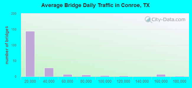
- 4,634,990Total average daily traffic
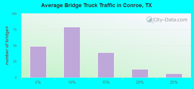
- 504,720Total average daily truck traffic
- National Bridge Inventory (NBI) Registered Bridges for Conroe
- No street view available for this location
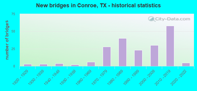
- New bridges - historical statistics
- 31920-1929
- 31930-1939
- 41940-1949
- 21950-1959
- 61960-1969
- 281970-1979
- 401980-1989
- 231990-1999
- 302000-2009
- 582010-2019
- 52020-2022
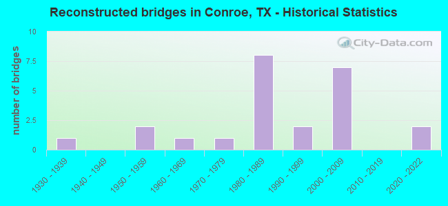
- Reconstructed bridges - Historical Statistics
- 11930-1939
- 01940-1949
- 21950-1959
- 11960-1969
- 11970-1979
- 81980-1989
- 21990-1999
- 72000-2009
- 02010-2019
- 22020-2022
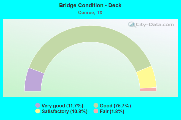
- Bridge Condition - Deck
- 11.7%Very good
- 75.7%Good
- 10.8%Satisfactory
- 1.8%Fair
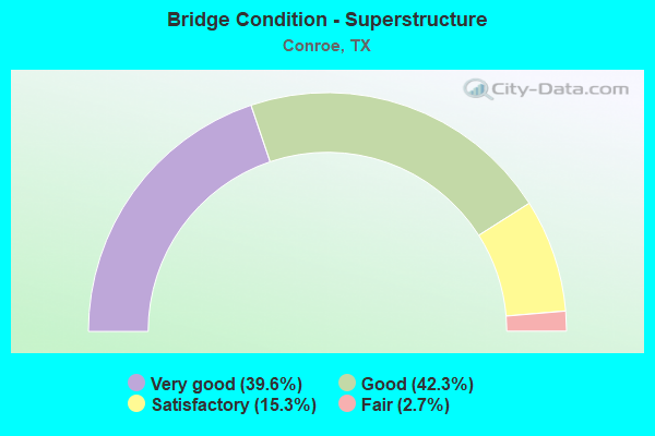
- Bridge Condition - Superstructure
- 39.6%Very good
- 42.3%Good
- 15.3%Satisfactory
- 2.7%Fair
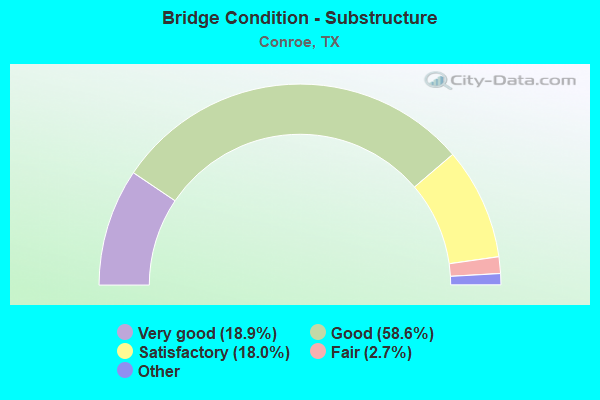
- Bridge Condition - Substructure
- 18.9%Excellent
- 58.6%Very good
- 18.0%Good
- 2.7%Satisfactory
- 1.8%Fair
- 0.9%Poor
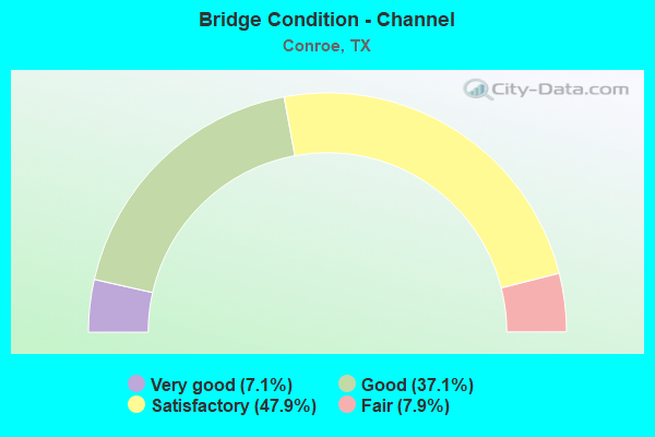
- Bridge Condition - Channel
- 7.1%Very good
- 37.1%Good
- 47.9%Satisfactory
- 7.9%Fair
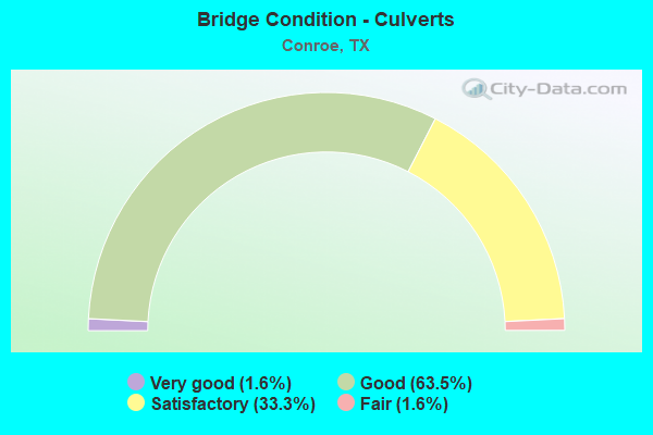
- Bridge Condition - Culverts
- 1.6%Very good
- 63.5%Good
- 33.3%Satisfactory
- 1.6%Fair
Find on map >> Show street view
Structure Number: 121700125901012, Location: 4.20 MI W OF IH 45 (Lat: 30.431353, Lng: -95.561897), Route carried "on" structure: State highway 1097, Year Built: 1972, Status: Open, Structure Length: 3.66m (12.01ft), Average Daily Traffic: 13,838 (year 2020), Truck Traffic: 7%, Average Future Daily Traffic: 21,260 (year 2033), Design Load: HS 20, Features Intersected: LEWIS CREEK
Minimum Vertical Clearance: 30+ m (98+ ft), Kilometerpoint: 31.093, Lanes on structure: 2, Owner: State Highway Agency, Approaching Roadway Width: 12.2m (40.0ft), Material/Design: Concrete, Design/Construction: Stringer/Multi-beam, Number Of Spans In Main Unit: 3, Length of Maximum Span: 12.2m (40.0ft), Curb-To-Curb Width: 12.2m (40.0ft), Out-to-Out Width: 12.7m (41.7ft)
Condition: Deck: Good, Superstructure: Good, Substructure: Good, Channel: Good, Operating Rating: 68.0 metric tons, Method Used To Determine Operating Rating: Load Factor (LF), Inventory Rating: 40.8 metric tons, Method Used To Determine Inventory Rating: Load Factor (LF), Structural Evaluation: Better than present minimum criteria, Deck Geometry: Somewhat better than minimum adequacy, Waterway Adequacy: Superior to present desirable criteria, Approach Roadway Alignment: Equal to present desirable criteria, Designated Inspection Frequency: Every 24 months, Underwater Inspection Frequency: Every 60 months, Inspection Date: October 2020, Underwater Inspection Date: October 2020, Deck Structure Type: Concrete Cast-file-Place, Wearing Surface/Protective System: Wearing Surface: Bituminous
Find on map >> Show street view
Structure Number: 121700141701004, Location: 0.80 MI NE OF FM 2432 (Lat: 30.396083, Lng: -95.397506), Route carried "on" structure: State highway 1484, Year Built: 1954, Year Reconstructed: 1994, Status: Open, Structure Length: 1.83m (6.00ft), Average Daily Traffic: 9,585 (year 2020), Truck Traffic: 9%, Average Future Daily Traffic: 13,940 (year 2033), Design Load: H 15, Features Intersected: CAMP CREEK
Minimum Vertical Clearance: 30+ m (98+ ft), Kilometerpoint: 10.527, Lanes on structure: 2, Owner: State Highway Agency, Approaching Roadway Width: 10.4m (34.1ft), Material/Design: Concrete, Design/Construction: Stringer/Multi-beam, Number Of Spans In Main Unit: 2, Length of Maximum Span: 9.1m (29.9ft), Curb-To-Curb Width: 13.8m (45.3ft), Out-to-Out Width: 14.6m (47.9ft)
Condition: Deck: Good, Superstructure: Satisfactory, Substructure: Satisfactory, Channel: Satisfactory, Operating Rating: 48.1 metric tons, Method Used To Determine Operating Rating: Load Factor (LF), Inventory Rating: 29.0 metric tons, Method Used To Determine Inventory Rating: Load Factor (LF), Structural Evaluation: Equal to present minimum criteria, Deck Geometry: Superior to present desirable criteria, Waterway Adequacy: Equal to present minimum criteria, Approach Roadway Alignment: Equal to present desirable criteria, Length Of Structure Improvement: 1.83m (6.00ft), Designated Inspection Frequency: Every 24 months, Inspection Date: October 2020, Bridge Improvement Cost: $24,000, Roadway Improvement Cost: $6,000, Total Project Cost: $30,000, Deck Structure Type: Concrete Cast-file-Place
Find on map >> Show street view
Structure Number: 121700141701012, Location: 2.1 MI NE OF FM 3083 (Lat: 30.371678, Lng: -95.424858), Route carried "on" structure: State highway 1484, Year Built: 2010, Status: Open, Structure Length: 9.75m (31.99ft), Average Daily Traffic: 12,795 (year 2020), Truck Traffic: 7%, Average Future Daily Traffic: 15,000 (year 2036), Design Load: HL 93, Features Intersected: CRYSTAL CREEK
Minimum Vertical Clearance: 30+ m (98+ ft), Kilometerpoint: 0.002, Lanes on structure: 5, Owner: State Highway Agency, Approaching Roadway Width: 25.6m (84.0ft), Material/Design: Prestressed concrete, Design/Construction: Box Beam or Girders - Multiple, Number Of Spans In Main Unit: 4, Length of Maximum Span: 24.4m (80.1ft), Curb-To-Curb Width: 25.6m (84.0ft), Out-to-Out Width: 26.3m (86.3ft)
Condition: Deck: Good, Superstructure: Good, Substructure: Very good, Channel: Good, Operating Rating: 54.4 metric tons, Method Used To Determine Operating Rating: Assigned ratings based on Load and Resistance Factor Design (LRFD) reported in metric tons, Inventory Rating: 32.7 metric tons, Method Used To Determine Inventory Rating: Assigned ratings based on Load and Resistance Factor Design (LRFD) reported in metric tons, Structural Evaluation: Better than present minimum criteria, Deck Geometry: Superior to present desirable criteria, Waterway Adequacy: Superior to present desirable criteria, Approach Roadway Alignment: Equal to present desirable criteria, Designated Inspection Frequency: Every 24 months, Inspection Date: October 2020, Deck Structure Type: Concrete Cast-file-Place
Find on map >> Show street view
Structure Number: 121700141701013, Location: 2.4 MI NE OF FM 3083 (Lat: 30.372364, Lng: -95.419703), Route carried "on" structure: State highway 1484, Year Built: 2010, Status: Open, Structure Length: 2.07m (6.79ft), Average Daily Traffic: 12,795 (year 2020), Truck Traffic: 7%, Average Future Daily Traffic: 15,000 (year 2036), Design Load: HS 20, Features Intersected: CRYSTAL CREEK TRIBUTARY
Minimum Vertical Clearance: 30+ m (98+ ft), Kilometerpoint: 0.002, Lanes on structure: 5, Owner: State Highway Agency, Approaching Roadway Width: 25.6m (84.0ft), Skew: 4 degrees, Material/Design: Concrete, Design/Construction: Culvert, Number Of Spans In Main Unit: 4, Length of Maximum Span: 4.3m (14.1ft)
Condition: Channel: Very good, Culverts: Good, Operating Rating: 54.4 metric tons, Method Used To Determine Operating Rating: Assigned rating based on Load Factor Design (LFD) reported in metric tons, Inventory Rating: 32.7 metric tons, Method Used To Determine Inventory Rating: Assigned rating based on Load Factor Design (LFD) reported in metric tons, Structural Evaluation: Better than present minimum criteria, Waterway Adequacy: Superior to present desirable criteria, Approach Roadway Alignment: Equal to present desirable criteria, Designated Inspection Frequency: Every 24 months, Inspection Date: November 2020
Find on map >> Show street view
Structure Number: 121700198601002, Location: 2.50 MI SE OF LP 336 (Lat: 30.258181, Lng: -95.399908), Route carried "on" structure: State highway 1314, Year Built: 1946, Status: Open, Structure Length: 0.82m (2.69ft), Average Daily Traffic: 10,548 (year 2020), Truck Traffic: 9%, Average Future Daily Traffic: 12,490 (year 2033), Features Intersected: SANDY BRANCH
Minimum Vertical Clearance: 30+ m (98+ ft), Kilometerpoint: 9.241, Lanes on structure: 2, Owner: State Highway Agency, Approaching Roadway Width: 11.0m (36.1ft), Material/Design: Concrete, Design/Construction: Culvert, Number Of Spans In Main Unit: 4, Length of Maximum Span: 1.8m (5.9ft), Curb-To-Curb Width: 11.0m (36.1ft), Out-to-Out Width: 13.0m (42.7ft)
Condition: Channel: Fair, Culverts: Good, Operating Rating: 32.7 metric tons, Method Used To Determine Operating Rating: Field evaluation and documented engineering judgment, Inventory Rating: 24.5 metric tons, Method Used To Determine Inventory Rating: Field evaluation and documented engineering judgment, Structural Evaluation: Equal to present minimum criteria, Deck Geometry: Meets minimum limits, Waterway Adequacy: Equal to present minimum criteria, Approach Roadway Alignment: Equal to present desirable criteria, Designated Inspection Frequency: Every 24 months, Inspection Date: October 2020, Deck Structure Type: Concrete Cast-file-Place, Wearing Surface/Protective System: Wearing Surface: Bituminous
Find on map >> Show street view
Structure Number: 121700198601006, Location: 0.55 MI SE OF LP 336 (Lat: 30.279975, Lng: -95.420425), Route carried "on" structure: State highway 1314, Year Built: 1986, Status: Open, Structure Length: 3.66m (12.01ft), Average Daily Traffic: 7,095 (year 2020), Truck Traffic: 5%, Average Future Daily Traffic: 12,030 (year 2033), Design Load: HS 20, Features Intersected: LITTLE CANEY CREEK
Minimum Vertical Clearance: 30+ m (98+ ft), Kilometerpoint: 6.088, Lanes on structure: 2, Owner: State Highway Agency, Approaching Roadway Width: 11.6m (38.1ft), Material/Design: Concrete, Design/Construction: Stringer/Multi-beam, Number Of Spans In Main Unit: 3, Length of Maximum Span: 12.2m (40.0ft), Curb-To-Curb Width: 15.6m (51.2ft), Out-to-Out Width: 16.5m (54.1ft)
Condition: Deck: Satisfactory, Superstructure: Satisfactory, Substructure: Good, Channel: Good, Operating Rating: 68.0 metric tons, Method Used To Determine Operating Rating: Load Factor (LF), Inventory Rating: 40.8 metric tons, Method Used To Determine Inventory Rating: Load Factor (LF), Structural Evaluation: Equal to present minimum criteria, Deck Geometry: Superior to present desirable criteria, Waterway Adequacy: Equal to present minimum criteria, Approach Roadway Alignment: Equal to present desirable criteria, Designated Inspection Frequency: Every 24 months, Inspection Date: October 2020, Deck Structure Type: Concrete Cast-file-Place
Find on map >> Show street view
Structure Number: 121700274401001, Location: 3.2 MI W OF IH 45 (Lat: 30.315458, Lng: -95.522408), Route carried "on" structure: State highway 2854, Year Built: 1968, Status: Open, Structure Length: 7.32m (24.02ft), Average Daily Traffic: 13,939 (year 2016), Truck Traffic: 5%, Average Future Daily Traffic: 12,610 (year 2033), Design Load: H 20, Features Intersected: SAN JACINTO RIV REL
Minimum Vertical Clearance: 30+ m (98+ ft), Kilometerpoint: 21.496, Lanes on structure: 2, Owner: State Highway Agency, Approaching Roadway Width: 10.1m (33.1ft), Material/Design: Prestressed concrete, Design/Construction: Stringer/Multi-beam, Number Of Spans In Main Unit: 4, Length of Maximum Span: 18.3m (60.0ft), Curb-To-Curb Width: 10.1m (33.1ft), Out-to-Out Width: 10.6m (34.8ft)
Condition: Deck: Good, Superstructure: Good, Substructure: Satisfactory, Channel: Satisfactory, Operating Rating: 57.1 metric tons, Method Used To Determine Operating Rating: Load Factor (LF), Inventory Rating: 29.9 metric tons, Method Used To Determine Inventory Rating: Load Factor (LF), Structural Evaluation: Equal to present minimum criteria, Deck Geometry: Meets minimum limits, Waterway Adequacy: Equal to present minimum criteria, Approach Roadway Alignment: Equal to present desirable criteria, Designated Inspection Frequency: Every 24 months, Inspection Date: September 2020, Deck Structure Type: Concrete Cast-file-Place
Find on map >> Show street view
Structure Number: 121700274401002, Location: 2.6 MI W OF IH 45 (Lat: 30.314533, Lng: -95.511442), Route carried "on" structure: State highway 2854, Year Built: 1968, Status: Open, Structure Length: 9.30m (30.51ft), Average Daily Traffic: 13,939 (year 2016), Truck Traffic: 5%, Average Future Daily Traffic: 12,610 (year 2033), Design Load: H 20, Features Intersected: SAN JACINTO RIVER
Minimum Vertical Clearance: 30+ m (98+ ft), Kilometerpoint: 22.524, Lanes on structure: 2, Owner: State Highway Agency, Approaching Roadway Width: 10.1m (33.1ft), Material/Design: Prestressed concrete, Design/Construction: Stringer/Multi-beam, Number Of Spans In Main Unit: 5, Length of Maximum Span: 19.8m (65.0ft), Curb-To-Curb Width: 10.1m (33.1ft), Out-to-Out Width: 10.6m (34.8ft)
Condition: Deck: Good, Superstructure: Good, Substructure: Satisfactory, Channel: Fair, Operating Rating: 57.1 metric tons, Method Used To Determine Operating Rating: Load Factor (LF), Inventory Rating: 27.2 metric tons, Method Used To Determine Inventory Rating: Load Factor (LF), Structural Evaluation: Equal to present minimum criteria, Deck Geometry: Meets minimum limits, Waterway Adequacy: Equal to present minimum criteria, Approach Roadway Alignment: Equal to present desirable criteria, Designated Inspection Frequency: Every 24 months, Inspection Date: September 2020, Deck Structure Type: Concrete Cast-file-Place
Find on map >> Show street view
Structure Number: 121700274401006, Location: 9.1 MI W OF IH 45 (Lat: 30.318403, Lng: -95.624389), Route carried "on" structure: State highway 2854, Year Built: 1972, Status: Open, Structure Length: 4.88m (16.01ft), Average Daily Traffic: 8,005 (year 2020), Truck Traffic: 9%, Average Future Daily Traffic: 9,790 (year 2033), Features Intersected: MOUND CREEK
Minimum Vertical Clearance: 30+ m (98+ ft), Kilometerpoint: 11.624, Lanes on structure: 2, Owner: State Highway Agency, Approaching Roadway Width: 14.6m (47.9ft), Material/Design: Concrete, Design/Construction: Stringer/Multi-beam, Number Of Spans In Main Unit: 4, Length of Maximum Span: 12.2m (40.0ft), Curb-To-Curb Width: 14.6m (47.9ft), Out-to-Out Width: 15.2m (49.9ft)
Condition: Deck: Good, Superstructure: Good, Substructure: Good, Channel: Satisfactory, Operating Rating: 32.7 metric tons, Method Used To Determine Operating Rating: Field evaluation and documented engineering judgment, Inventory Rating: 24.5 metric tons, Method Used To Determine Inventory Rating: Field evaluation and documented engineering judgment, Structural Evaluation: Equal to present minimum criteria, Deck Geometry: Superior to present desirable criteria, Waterway Adequacy: Equal to present minimum criteria, Approach Roadway Alignment: Equal to present desirable criteria, Designated Inspection Frequency: Every 24 months, Inspection Date: September 2020, Deck Structure Type: Concrete Cast-file-Place
Find on map >> Show street view
Structure Number: 121700274401008, Location: 3.90 MI SE OF SH 105 (Lat: 30.340800, Lng: -95.652339), Route carried "on" structure: State highway 2854, Year Built: 1980, Status: Open, Structure Length: 1.49m (4.89ft), Average Daily Traffic: 7,148 (year 2020), Truck Traffic: 6%, Average Future Daily Traffic: 7,770 (year 2033), Features Intersected: BR OF MOUND CRK
Minimum Vertical Clearance: 30+ m (98+ ft), Kilometerpoint: 6.540, Lanes on structure: 2, Owner: State Highway Agency, Approaching Roadway Width: 9.8m (32.2ft), Material/Design: Concrete, Design/Construction: Culvert, Number Of Spans In Main Unit: 5, Length of Maximum Span: 2.7m (8.9ft)
Condition: Channel: Fair, Culverts: Satisfactory, Operating Rating: 39.9 metric tons, Method Used To Determine Operating Rating: Load Factor (LF), Inventory Rating: 23.6 metric tons, Method Used To Determine Inventory Rating: Load Factor (LF), Structural Evaluation: Somewhat better than minimum adequacy, Waterway Adequacy: Equal to present minimum criteria, Approach Roadway Alignment: Equal to present desirable criteria, Designated Inspection Frequency: Every 24 months, Inspection Date: November 2020
Find on map >> Show street view
Structure Number: 121700274401216, Location: 2.40 MI S OF SH 105 (Lat: 30.320333, Lng: -95.588336), Route carried "on" structure: County highway 2854, Year Built: 2011, Status: Open, Structure Length: 29.23m (95.90ft), Average Daily Traffic: 2,300 (year 2010), Truck Traffic: 1%, Average Future Daily Traffic: 3,100 (year 2030), Design Load: HL 93, Features Intersected: FM 2854 / BNSF, Facility Carried by Structure: FISH CREEK ROAD
Minimum Vertical Clearance: 30+ m (98+ ft), Kilometerpoint: 14.798, Lanes on structure: 2, Lanes under structure: 2, Owner: County Highway Agency, Approaching Roadway Width: 12.2m (40.0ft), Material/Design: Steel, Design/Construction: Stringer/Multi-beam, Number Of Spans In Main Unit: 1, Number Of Approach Spans: 7, Length of Maximum Span: 47.2m (154.9ft), Curb-To-Curb Width: 12.3m (40.4ft), Out-to-Out Width: 12.9m (42.3ft)
Condition: Deck: Good, Superstructure: Good, Substructure: Good, Operating Rating: 54.4 metric tons, Method Used To Determine Operating Rating: Assigned ratings based on Load and Resistance Factor Design (LRFD) reported in metric tons, Inventory Rating: 32.7 metric tons, Method Used To Determine Inventory Rating: Assigned ratings based on Load and Resistance Factor Design (LRFD) reported in metric tons, Structural Evaluation: Better than present minimum criteria, Deck Geometry: Equal to present minimum criteria, Underclear: High priority of corrective action, Approach Roadway Alignment: Equal to present desirable criteria, Designated Inspection Frequency: Every 24 months, Inspection Date: August 2020, Deck Structure Type: Concrete Cast-file-Place
Find on map >> Show street view
Structure Number: 121700274401217, Location: 0.2 MI E OF IH 45 (Lat: 30.308142, Lng: -95.472569), Route carried "on" structure: State highway 2854, Year Built: 2020, Status: Open, Structure Length: 4.30m (14.11ft), Average Daily Traffic: 9,910 (year 2019), Truck Traffic: 7%, Average Future Daily Traffic: 11,892 (year 2039), Design Load: HL 93, Features Intersected: ALLIGATOR CREEK
Minimum Vertical Clearance: 30+ m (98+ ft), Kilometerpoint: 26.440, Lanes on structure: 5, Owner: State Highway Agency, Approaching Roadway Width: 20.7m (67.9ft), Skew: 3 degrees, Material/Design: Prestressed concrete, Design/Construction: Slab, Number Of Spans In Main Unit: 3, Length of Maximum Span: 14.3m (46.9ft), Curb or Sidewalk Widths: Left: 2.0m (6.6ft), Right: 0.0m, Curb-To-Curb Width: 20.7m (67.9ft), Out-to-Out Width: 23.4m (76.8ft)
Condition: Deck: Good, Superstructure: Very good, Substructure: Very good, Channel: Good, Operating Rating: 54.4 metric tons, Method Used To Determine Operating Rating: Assigned ratings based on Load and Resistance Factor Design (LRFD) reported in metric tons, Inventory Rating: 32.7 metric tons, Method Used To Determine Inventory Rating: Assigned ratings based on Load and Resistance Factor Design (LRFD) reported in metric tons, Structural Evaluation: Equal to present desirable criteria, Deck Geometry: Somewhat better than minimum adequacy, Waterway Adequacy: Equal to present desirable criteria, Approach Roadway Alignment: Equal to present desirable criteria, Designated Inspection Frequency: Every 24 months, Inspection Date: November 2020, Deck Structure Type: Concrete Cast-file-Place
Find on map >> Show street view
Structure Number: 121700274401218, Location: 2.4 MI S OF SH 105 (Lat: 30.317725, Lng: -95.588053), Route carried "on" structure: County highway , Year Built: 2020, Status: Open, Structure Length: 29.23m (95.90ft), Average Daily Traffic: 6,500 (year 2016), Truck Traffic: 3%, Average Future Daily Traffic: 26,700 (year 2040), Design Load: HL 93, Features Intersected: FM 2854 / BNSF, Facility Carried by Structure: FISH CREEK RD NB
Minimum Vertical Clearance: 30+ m (98+ ft), Kilometerpoint: 0.000, Lanes on structure: 2, Lanes under structure: 4, Owner: County Highway Agency, Maintenance Responsibility: State Highway Agency, Approaching Roadway Width: 12.2m (40.0ft), Material/Design: Steel, Design/Construction: Stringer/Multi-beam, Number Of Spans In Main Unit: 1, Number Of Approach Spans: 7, Length of Maximum Span: 48.2m (158.1ft), Curb-To-Curb Width: 12.2m (40.0ft), Out-to-Out Width: 12.8m (42.0ft)
Condition: Deck: Very good, Superstructure: Very good, Substructure: Very good, Operating Rating: 54.4 metric tons, Method Used To Determine Operating Rating: Assigned ratings based on Load and Resistance Factor Design (LRFD) reported in metric tons, Inventory Rating: 32.7 metric tons, Method Used To Determine Inventory Rating: Assigned ratings based on Load and Resistance Factor Design (LRFD) reported in metric tons, Structural Evaluation: Equal to present desirable criteria, Deck Geometry: Better than present minimum criteria, Underclear: Superior to present desirable criteria, Approach Roadway Alignment: Equal to present desirable criteria, Designated Inspection Frequency: Every 24 months, Inspection Date: December 2020, Deck Structure Type: Concrete Cast-file-Place
Find on map >> Show street view
Structure Number: 121700289701001, Location: 0.35 MI W OF IH 45 (Lat: 30.391181, Lng: -95.492508), Route carried "on" structure: State highway 830, Year Built: 1970, Status: Open, Structure Length: 0.98m (3.22ft), Average Daily Traffic: 12,163 (year 2020), Truck Traffic: 1%, Average Future Daily Traffic: 15,350 (year 2033), Features Intersected: STEWART CREEK
Minimum Vertical Clearance: 30+ m (98+ ft), Kilometerpoint: 8.053, Lanes on structure: 3, Owner: State Highway Agency, Approaching Roadway Width: 16.2m (53.1ft), Skew: 1 degrees, Material/Design: Concrete, Design/Construction: Culvert, Number Of Spans In Main Unit: 4, Length of Maximum Span: 2.1m (6.9ft)
Condition: Channel: Fair, Culverts: Satisfactory, Operating Rating: 39.9 metric tons, Method Used To Determine Operating Rating: Load Factor (LF), Inventory Rating: 23.6 metric tons, Method Used To Determine Inventory Rating: Load Factor (LF), Structural Evaluation: Somewhat better than minimum adequacy, Waterway Adequacy: Equal to present minimum criteria, Approach Roadway Alignment: Equal to present desirable criteria, Designated Inspection Frequency: Every 24 months, Inspection Date: October 2020
Find on map >> Show street view
Structure Number: 121700289701002, Location: 4.80 MI W OF IH 45 (Lat: 30.411164, Lng: -95.562164), Route carried "on" structure: State highway 830, Year Built: 1971, Status: Open, Structure Length: 0.70m (2.30ft), Average Daily Traffic: 5,810 (year 2020), Truck Traffic: 7%, Average Future Daily Traffic: 7,330 (year 2033), Design Load: HS 20, Features Intersected: SLOUGH
Minimum Vertical Clearance: 30+ m (98+ ft), Kilometerpoint: 0.877, Lanes on structure: 2, Owner: State Highway Agency, Approaching Roadway Width: 13.7m (44.9ft), Material/Design: Concrete, Design/Construction: Culvert, Number Of Spans In Main Unit: 4, Length of Maximum Span: 1.5m (4.9ft)
Condition: Channel: Satisfactory, Culverts: Good, Operating Rating: 39.9 metric tons, Method Used To Determine Operating Rating: Load Factor (LF), Inventory Rating: 23.6 metric tons, Method Used To Determine Inventory Rating: Load Factor (LF), Structural Evaluation: Somewhat better than minimum adequacy, Waterway Adequacy: Equal to present minimum criteria, Approach Roadway Alignment: Equal to present desirable criteria, Designated Inspection Frequency: Every 24 months, Inspection Date: November 2020
Find on map >> Show street view
Structure Number: 121700289701003, Location: 3.70 MI W OF IH 45 (Lat: 30.407019, Lng: -95.544339), Route carried "on" structure: State highway 830, Year Built: 1971, Status: Open, Structure Length: 1.10m (3.61ft), Average Daily Traffic: 5,810 (year 2020), Truck Traffic: 7%, Average Future Daily Traffic: 7,330 (year 2033), Design Load: HS 20, Features Intersected: BELL CREEK
Minimum Vertical Clearance: 30+ m (98+ ft), Kilometerpoint: 2.643, Lanes on structure: 2, Owner: State Highway Agency, Approaching Roadway Width: 12.5m (41.0ft), Skew: 1 degrees, Material/Design: Concrete, Design/Construction: Culvert, Number Of Spans In Main Unit: 4, Length of Maximum Span: 2.4m (7.9ft)
Condition: Channel: Fair, Culverts: Satisfactory, Operating Rating: 39.9 metric tons, Method Used To Determine Operating Rating: Load Factor (LF), Inventory Rating: 23.6 metric tons, Method Used To Determine Inventory Rating: Load Factor (LF), Structural Evaluation: Somewhat better than minimum adequacy, Waterway Adequacy: Equal to present minimum criteria, Approach Roadway Alignment: Equal to present desirable criteria, Designated Inspection Frequency: Every 24 months, Inspection Date: October 2020
Find on map >> Show street view
Structure Number: 121700289701004, Location: 3.55 MI W OF IH 45 (Lat: 30.406567, Lng: -95.542342), Route carried "on" structure: State highway 830, Year Built: 1971, Status: Open, Structure Length: 1.40m (4.59ft), Average Daily Traffic: 5,810 (year 2020), Truck Traffic: 7%, Average Future Daily Traffic: 7,330 (year 2033), Design Load: HS 20, Features Intersected: LIVE BRANCH
Minimum Vertical Clearance: 30+ m (98+ ft), Kilometerpoint: 2.842, Lanes on structure: 2, Owner: State Highway Agency, Approaching Roadway Width: 12.5m (41.0ft), Skew: 3 degrees, Material/Design: Concrete, Design/Construction: Culvert, Number Of Spans In Main Unit: 6, Length of Maximum Span: 2.1m (6.9ft)
Condition: Channel: Fair, Culverts: Satisfactory, Operating Rating: 39.9 metric tons, Method Used To Determine Operating Rating: Load Factor (LF), Inventory Rating: 23.6 metric tons, Method Used To Determine Inventory Rating: Load Factor (LF), Structural Evaluation: Somewhat better than minimum adequacy, Waterway Adequacy: Equal to present minimum criteria, Approach Roadway Alignment: Equal to present desirable criteria, Designated Inspection Frequency: Every 24 months, Inspection Date: October 2020
Find on map >> Show street view
Structure Number: 121700315801004, Location: 3.20 MI SE OF LP 336 (Lat: 30.276711, Lng: -95.358531), Route carried "on" structure: State highway 3083, Year Built: 1971, Status: Open, Structure Length: 4.88m (16.01ft), Average Daily Traffic: 10,659 (year 2016), Truck Traffic: 9%, Average Future Daily Traffic: 12,640 (year 2033), Design Load: HS 20, Features Intersected: WEST FORK CRYSTAL CREEK
Minimum Vertical Clearance: 30+ m (98+ ft), Kilometerpoint: 19.574, Lanes on structure: 2, Owner: State Highway Agency, Approaching Roadway Width: 11.6m (38.1ft), Material/Design: Concrete, Design/Construction: Stringer/Multi-beam, Number Of Spans In Main Unit: 4, Length of Maximum Span: 12.2m (40.0ft), Curb-To-Curb Width: 14.6m (47.9ft), Out-to-Out Width: 15.1m (49.5ft)
Condition: Deck: Good, Superstructure: Fair, Substructure: Satisfactory, Channel: Satisfactory, Operating Rating: 68.0 metric tons, Method Used To Determine Operating Rating: Load Factor (LF), Inventory Rating: 40.8 metric tons, Method Used To Determine Inventory Rating: Load Factor (LF), Structural Evaluation: Somewhat better than minimum adequacy, Deck Geometry: Superior to present desirable criteria, Waterway Adequacy: Equal to present minimum criteria, Approach Roadway Alignment: Equal to present desirable criteria, Designated Inspection Frequency: Every 24 months, Inspection Date: October 2020, Deck Structure Type: Concrete Cast-file-Place, Wearing Surface/Protective System: Wearing Surface: Bituminous
Find on map >> Show street view
Structure Number: 121700315801005, Location: 3.35 MI SE OF LP 336 (Lat: 30.275531, Lng: -95.356892), Route carried "on" structure: State highway 3083, Year Built: 1971, Status: Open, Structure Length: 6.10m (20.01ft), Average Daily Traffic: 10,659 (year 2016), Truck Traffic: 9%, Average Future Daily Traffic: 12,640 (year 2033), Design Load: HS 20, Features Intersected: EAST FORK CRYSTAL CREEK
Minimum Vertical Clearance: 30+ m (98+ ft), Kilometerpoint: 19.772, Lanes on structure: 2, Owner: State Highway Agency, Approaching Roadway Width: 11.6m (38.1ft), Material/Design: Concrete, Design/Construction: Stringer/Multi-beam, Number Of Spans In Main Unit: 5, Length of Maximum Span: 12.2m (40.0ft), Curb-To-Curb Width: 14.6m (47.9ft), Out-to-Out Width: 15.1m (49.5ft)
Condition: Deck: Good, Superstructure: Satisfactory, Substructure: Good, Channel: Satisfactory, Operating Rating: 68.0 metric tons, Method Used To Determine Operating Rating: Load Factor (LF), Inventory Rating: 40.8 metric tons, Method Used To Determine Inventory Rating: Load Factor (LF), Structural Evaluation: Equal to present minimum criteria, Deck Geometry: Superior to present desirable criteria, Waterway Adequacy: Equal to present minimum criteria, Approach Roadway Alignment: Equal to present desirable criteria, Designated Inspection Frequency: Every 24 months, Inspection Date: October 2020, Deck Structure Type: Concrete Cast-file-Place, Wearing Surface/Protective System: Wearing Surface: Bituminous
Find on map >> Show street view
Structure Number: 121700315801006, Location: 1.10 MI E OF US 75 (Lat: 30.349997, Lng: -95.453689), Route carried "on" structure: State highway 3083, Year Built: 1989, Year Reconstructed: 2020, Status: Open, Structure Length: 3.66m (12.01ft), Average Daily Traffic: 19,309 (year 2020), Truck Traffic: 8%, Average Future Daily Traffic: 25,745 (year 2039), Design Load: HS 20, Features Intersected: STEWARTS CREEK
Minimum Vertical Clearance: 30+ m (98+ ft), Kilometerpoint: 14.732, Lanes on structure: 5, Owner: State Highway Agency, Approaching Roadway Width: 25.6m (84.0ft), Material/Design: Prestressed concrete, Design/Construction: Box Beam or Girders - Multiple, Number Of Spans In Main Unit: 3, Length of Maximum Span: 12.2m (40.0ft), Curb-To-Curb Width: 25.6m (84.0ft), Out-to-Out Width: 26.4m (86.6ft)
Condition: Deck: Good, Superstructure: Very good, Substructure: Good, Channel: Good, Operating Rating: 54.4 metric tons, Method Used To Determine Operating Rating: Assigned rating based on Load Factor Design (LFD) reported in metric tons, Inventory Rating: 32.7 metric tons, Method Used To Determine Inventory Rating: Assigned rating based on Load Factor Design (LFD) reported in metric tons, Structural Evaluation: Better than present minimum criteria, Deck Geometry: Superior to present desirable criteria, Waterway Adequacy: Superior to present desirable criteria, Approach Roadway Alignment: Equal to present desirable criteria, Designated Inspection Frequency: Every 24 months, Inspection Date: October 2020, Deck Structure Type: Concrete Cast-file-Place
Find on map >> Show street view
Structure Number: 121700315801007, Location: 1.70 MI E OF US 75 (Lat: 30.350214, Lng: -95.445867), Route carried "on" structure: State highway 3083, Year Built: 1989, Year Reconstructed: 2020, Status: Open, Structure Length: 1.68m (5.51ft), Average Daily Traffic: 19,309 (year 2020), Truck Traffic: 4%, Average Future Daily Traffic: 14,760 (year 2033), Design Load: HS 20, Features Intersected: LITTLE CANEY CR
Minimum Vertical Clearance: 30+ m (98+ ft), Kilometerpoint: 15.521, Lanes on structure: 5, Owner: State Highway Agency, Approaching Roadway Width: 25.6m (84.0ft), Skew: 4 degrees, Material/Design: Concrete, Design/Construction: Culvert, Number Of Spans In Main Unit: 5, Length of Maximum Span: 3.0m (9.8ft)
Condition: Channel: Good, Culverts: Good, Operating Rating: 39.9 metric tons, Method Used To Determine Operating Rating: Load Factor (LF), Inventory Rating: 23.6 metric tons, Method Used To Determine Inventory Rating: Load Factor (LF), Structural Evaluation: Somewhat better than minimum adequacy, Waterway Adequacy: Equal to present minimum criteria, Approach Roadway Alignment: Equal to present desirable criteria, Designated Inspection Frequency: Every 48 months, Inspection Date: November 2020
Find on map >> Show street view
Structure Number: 121700315801008, Location: 1.4 MI W OF IH 45 (Lat: 30.340833, Lng: -95.503525), Route carried "on" structure: State highway 3083, Year Built: 2004, Status: Open, Structure Length: 10.97m (35.99ft), Average Daily Traffic: 1,700 (year 2012), Truck Traffic: 17%, Average Future Daily Traffic: 3,640 (year 2032), Design Load: HS 20, Features Intersected: WHITE OAK CREEK
Minimum Vertical Clearance: 30+ m (98+ ft), Kilometerpoint: 1.125, Lanes on structure: 2, Owner: State Highway Agency, Approaching Roadway Width: 12.2m (40.0ft), Material/Design: Prestressed concrete, Design/Construction: Stringer/Multi-beam, Number Of Spans In Main Unit: 3, Length of Maximum Span: 36.6m (120.1ft), Curb-To-Curb Width: 12.2m (40.0ft), Out-to-Out Width: 13.0m (42.7ft)
Condition: Deck: Good, Superstructure: Good, Substructure: Good, Channel: Satisfactory, Operating Rating: 54.4 metric tons, Method Used To Determine Operating Rating: Assigned rating based on Load Factor Design (LFD) reported in metric tons, Inventory Rating: 32.7 metric tons, Method Used To Determine Inventory Rating: Assigned rating based on Load Factor Design (LFD) reported in metric tons, Structural Evaluation: Better than present minimum criteria, Deck Geometry: Better than present minimum criteria, Waterway Adequacy: Superior to present desirable criteria, Approach Roadway Alignment: Equal to present desirable criteria, Designated Inspection Frequency: Every 24 months, Inspection Date: October 2020, Deck Structure Type: Concrete Cast-file-Place
Find on map >> Show street view
Structure Number: 121700315801009, Location: 0.8 MI E OF SH 75 (Lat: 30.349928, Lng: -95.458919), Route carried "on" structure: State highway 3083, Year Built: 2020, Status: Open, Structure Length: 36.70m (120.41ft), Average Daily Traffic: 21,454 (year 2019), Truck Traffic: 8%, Average Future Daily Traffic: 25,745 (year 2039), Design Load: HL 93, Features Intersected: UPRR
Minimum Vertical Clearance: 30+ m (98+ ft), Kilometerpoint: 0.000, Lanes on structure: 4, Owner: State Highway Agency, Approaching Roadway Width: 20.7m (67.9ft), Skew: 21 degrees, Material/Design: Prestressed concrete, Design/Construction: Stringer/Multi-beam, Number Of Spans In Main Unit: 12, Length of Maximum Span: 33.5m (109.9ft), Curb-To-Curb Width: 20.8m (68.2ft), Out-to-Out Width: 26.5m (86.9ft)
Condition: Deck: Good, Superstructure: Very good, Substructure: Very good, Operating Rating: 54.4 metric tons, Method Used To Determine Operating Rating: Assigned ratings based on Load and Resistance Factor Design (LRFD) reported in metric tons, Inventory Rating: 32.7 metric tons, Method Used To Determine Inventory Rating: Assigned ratings based on Load and Resistance Factor Design (LRFD) reported in metric tons, Structural Evaluation: Equal to present desirable criteria, Deck Geometry: Superior to present desirable criteria, Underclear: Superior to present desirable criteria, Approach Roadway Alignment: Equal to present desirable criteria, Designated Inspection Frequency: Every 24 months, Inspection Date: December 2020, Deck Structure Type: Concrete Cast-file-Place
Find on map >> Show street view
Structure Number: 121700353801387, Location: JCT IH 45 and SH 242 (Lat: 30.207125, Lng: -95.455294), Route carried "on" structure: Ramp State highway 242, Year Built: 2014, Status: Open, Structure Length: 92.63m (303.90ft), Average Daily Traffic: 13,000 (year 2018), Truck Traffic: 10%, Average Future Daily Traffic: 1 (year 1900), Design Load: HL 93, Features Intersected: IH 45 & SH 242
Minimum Vertical Clearance: 5.12m (16.80ft), Kilometerpoint: 0.000, Lanes on structure: 1, Lanes under structure: 8, Toll: On toll road, Owner: State Highway Agency, Approaching Roadway Width: 7.9m (25.9ft), Material/Design: Steel continuous, Design/Construction: Stringer/Multi-beam, Number Of Spans In Main Unit: 6, Number Of Approach Spans: 14, Length of Maximum Span: 95.4m (313.0ft), Curb-To-Curb Width: 7.9m (25.9ft), Out-to-Out Width: 8.7m (28.5ft)
Condition: Deck: Good, Superstructure: Very good, Substructure: Very good, Operating Rating: 54.4 metric tons, Method Used To Determine Operating Rating: Assigned ratings based on Load and Resistance Factor Design (LRFD) reported in metric tons, Inventory Rating: 32.7 metric tons, Method Used To Determine Inventory Rating: Assigned ratings based on Load and Resistance Factor Design (LRFD) reported in metric tons, Structural Evaluation: Equal to present desirable criteria, Deck Geometry: Equal to present desirable criteria, Underclear: High priority of corrective action, Approach Roadway Alignment: Equal to present desirable criteria, Designated Inspection Frequency: Every 24 months, Inspection Date: December 2020, Deck Structure Type: Concrete Cast-file-Place
Find on map >> Show street view
Structure Number: 121700A00034001, Location: 0.65 MI N OF FM 830 (Lat: 30.413058, Lng: -95.528831), Route carried "on" structure: County highway , Year Built: 2004, Status: Open, Structure Length: 1.01m (3.31ft), Average Daily Traffic: 1,500 (year 2016), Truck Traffic: 1%, Average Future Daily Traffic: 3,000 (year 2036), Design Load: HS 20, Features Intersected: LIVE BRANCH, Facility Carried by Structure: ANDERSON RD
Minimum Vertical Clearance: 30+ m (98+ ft), Kilometerpoint: 1.046, Lanes on structure: 2, Owner: County Highway Agency, Approaching Roadway Width: 5.5m (18.0ft), Skew: 1 degrees, Material/Design: Concrete, Design/Construction: Stringer/Multi-beam, Number Of Spans In Main Unit: 1, Length of Maximum Span: 9.4m (30.8ft), Curb-To-Curb Width: 7.2m (23.6ft), Out-to-Out Width: 8.0m (26.2ft)
Condition: Deck: Good, Superstructure: Good, Substructure: Good, Channel: Satisfactory, Operating Rating: 68.0 metric tons, Method Used To Determine Operating Rating: Load Factor (LF), Inventory Rating: 40.8 metric tons, Method Used To Determine Inventory Rating: Load Factor (LF), Structural Evaluation: Better than present minimum criteria, Deck Geometry: High priority of corrective action, Waterway Adequacy: Better than present minimum criteria, Approach Roadway Alignment: Equal to present desirable criteria, Designated Inspection Frequency: Every 24 months, Inspection Date: December 2021, Deck Structure Type: Concrete Cast-file-Place
Find on map >> Show street view
Structure Number: 121700A0006001, Location: 0.17 MI W OF WOODFOREST (Lat: 30.269622, Lng: -95.542831), Route carried "on" structure: County highway , Year Built: 2015, Status: Open, Structure Length: 3.02m (9.91ft), Average Daily Traffic: 50 (year 2016), Truck Traffic: 1%, Average Future Daily Traffic: 100 (year 2036), Features Intersected: DRAINAGE DITCH, Facility Carried by Structure: DEERBOURNE RIDGE D
Minimum Vertical Clearance: 30+ m (98+ ft), Kilometerpoint: 0.274, Lanes on structure: 2, Owner: County Highway Agency, Approaching Roadway Width: 11.0m (36.1ft), Skew: 3 degrees, Material/Design: Concrete, Design/Construction: Culvert, Number Of Spans In Main Unit: 7, Length of Maximum Span: 3.0m (9.8ft)
Condition: Channel: Good, Culverts: Good, Operating Rating: 32.7 metric tons, Method Used To Determine Operating Rating: Field evaluation and documented engineering judgment, Inventory Rating: 24.5 metric tons, Method Used To Determine Inventory Rating: Field evaluation and documented engineering judgment, Structural Evaluation: Equal to present minimum criteria, Waterway Adequacy: Better than present minimum criteria, Approach Roadway Alignment: Equal to present desirable criteria, Designated Inspection Frequency: Every 24 months, Inspection Date: December 2021
Find on map >> Show street view
Structure Number: 121700A0008702, Location: 0.02 MI N OF WOODFOREST (Lat: 30.280692, Lng: -95.549103), Route carried "on" structure: County highway , Year Built: 2013, Status: Open, Structure Length: 0.73m (2.40ft), Average Daily Traffic: 100 (year 2016), Truck Traffic: 1%, Average Future Daily Traffic: 500 (year 2035), Features Intersected: DRAINAGE DITCH, Facility Carried by Structure: BONTERRA BLVD
Minimum Vertical Clearance: 30+ m (98+ ft), Kilometerpoint: 0.032, Lanes on structure: 2, Owner: County Highway Agency, Approaching Roadway Width: 9.8m (32.2ft), Material/Design: Concrete, Design/Construction: Culvert, Number Of Spans In Main Unit: 2, Length of Maximum Span: 3.0m (9.8ft), Curb or Sidewalk Widths: Left: 2.4m (7.9ft), Right: 0.0m
Condition: Channel: Good, Culverts: Good, Operating Rating: 32.7 metric tons, Method Used To Determine Operating Rating: Field evaluation and documented engineering judgment, Inventory Rating: 24.5 metric tons, Method Used To Determine Inventory Rating: Field evaluation and documented engineering judgment, Structural Evaluation: Equal to present minimum criteria, Waterway Adequacy: Better than present minimum criteria, Approach Roadway Alignment: Equal to present desirable criteria, Designated Inspection Frequency: Every 24 months, Inspection Date: December 2021
Find on map >> Show street view
Structure Number: 121700A00413017, Location: 0.04 MI W OF KINNERLY (Lat: 30.285350, Lng: -95.577289), Route carried "on" structure: County highway , Year Built: 2015, Status: Open, Structure Length: 0.98m (3.22ft), Average Daily Traffic: 100 (year 2015), Truck Traffic: 1%, Average Future Daily Traffic: 150 (year 2036), Features Intersected: DRAINAGE DITCH, Facility Carried by Structure: GRINNELL TRAIL
Minimum Vertical Clearance: 30+ m (98+ ft), Kilometerpoint: 0.064, Lanes on structure: 2, Owner: County Highway Agency, Approaching Roadway Width: 6.7m (22.0ft), Skew: 1 degrees, Material/Design: Concrete, Design/Construction: Culvert, Number Of Spans In Main Unit: 4, Length of Maximum Span: 1.8m (5.9ft)
Condition: Channel: Good, Culverts: Good, Operating Rating: 32.7 metric tons, Method Used To Determine Operating Rating: Field evaluation and documented engineering judgment, Inventory Rating: 24.5 metric tons, Method Used To Determine Inventory Rating: Field evaluation and documented engineering judgment, Structural Evaluation: Equal to present minimum criteria, Waterway Adequacy: Better than present minimum criteria, Approach Roadway Alignment: Equal to present desirable criteria, Designated Inspection Frequency: Every 24 months, Inspection Date: December 2021
Find on map >> Show street view
Structure Number: 121700A0046601, Location: 0.2 MI SW OF SH 105 (Lat: 30.375619, Lng: -95.643714), Route carried "on" structure: County highway , Year Built: 2000, Status: Open, Structure Length: 0.79m (2.59ft), Average Daily Traffic: 400 (year 2016), Truck Traffic: 1%, Average Future Daily Traffic: 600 (year 2036), Features Intersected: MARTIN CREEK, Facility Carried by Structure: BLUE HERON DR
Minimum Vertical Clearance: 30+ m (98+ ft), Kilometerpoint: 0.322, Lanes on structure: 2, Owner: County Highway Agency, Approaching Roadway Width: 7.3m (24.0ft), Material/Design: Steel, Design/Construction: Culvert, Number Of Spans In Main Unit: 1, Length of Maximum Span: 7.9m (25.9ft)
Condition: Channel: Good, Culverts: Good, Operating Rating: 44.4 metric tons, Method Used To Determine Operating Rating: No rating analysis performed, Inventory Rating: 32.7 metric tons, Method Used To Determine Inventory Rating: No rating analysis performed, Structural Evaluation: Better than present minimum criteria, Waterway Adequacy: Superior to present desirable criteria, Approach Roadway Alignment: Equal to present desirable criteria, Designated Inspection Frequency: Every 24 months, Inspection Date: December 2021
Find on map >> Show street view
Structure Number: 121700A01029029, Location: 0.06 MI SE OF KINGSTON CV (Lat: 30.408756, Lng: -95.564700), Route carried "on" structure: County highway , Year Built: 1988, Status: Open, Structure Length: 2.74m (8.99ft), Average Daily Traffic: 80 (year 2016), Truck Traffic: 1%, Average Future Daily Traffic: 100 (year 2036), Features Intersected: LAKE CONROE, Facility Carried by Structure: PLEASURE LAKE DR
Minimum Vertical Clearance: 30+ m (98+ ft), Kilometerpoint: 0.097, Lanes on structure: 2, Owner: County Highway Agency, Approaching Roadway Width: 8.5m (27.9ft), Skew: 1 degrees, Material/Design: Prestressed concrete, Number Of Spans In Main Unit: 3, Length of Maximum Span: 9.1m (29.9ft), Curb or Sidewalk Widths: Left: 1.3m (4.3ft), Right: 1.3m (4.3ft), Curb-To-Curb Width: 8.6m (28.2ft), Out-to-Out Width: 11.7m (38.4ft)
Condition: Deck: Good, Superstructure: Very good, Substructure: Good, Channel: Good, Operating Rating: 32.7 metric tons, Method Used To Determine Operating Rating: Field evaluation and documented engineering judgment, Inventory Rating: 24.5 metric tons, Method Used To Determine Inventory Rating: Field evaluation and documented engineering judgment, Structural Evaluation: Equal to present minimum criteria, Deck Geometry: Better than present minimum criteria, Waterway Adequacy: Better than present minimum criteria, Approach Roadway Alignment: Equal to present desirable criteria, Designated Inspection Frequency: Every 24 months, Inspection Date: December 2021, Deck Structure Type: Concrete Cast-file-Place
Find on map >> Show street view
Structure Number: 121700A01061032, Location: 0.4 MI E OF FISH CREEK TH (Lat: 30.298564, Lng: -95.572839), Route carried "on" structure: County highway , Year Built: 2000, Status: Open, Structure Length: 2.71m (8.89ft), Average Daily Traffic: 400 (year 2016), Truck Traffic: 1%, Average Future Daily Traffic: 600 (year 2036), Features Intersected: FISH CREEK, Facility Carried by Structure: RIDGE LAKE DR
Minimum Vertical Clearance: 30+ m (98+ ft), Kilometerpoint: 0.644, Lanes on structure: 2, Owner: County Highway Agency, Approaching Roadway Width: 6.1m (20.0ft), Material/Design: Steel, Design/Construction: Culvert, Number Of Spans In Main Unit: 4, Length of Maximum Span: 6.1m (20.0ft)
Condition: Channel: Very good, Culverts: Good, Operating Rating: 44.4 metric tons, Method Used To Determine Operating Rating: No rating analysis performed, Inventory Rating: 32.7 metric tons, Method Used To Determine Inventory Rating: No rating analysis performed, Structural Evaluation: Better than present minimum criteria, Waterway Adequacy: Better than present minimum criteria, Approach Roadway Alignment: Equal to present desirable criteria, Designated Inspection Frequency: Every 24 months, Inspection Date: December 2021
Find on map >> Show street view
Structure Number: 121700A01373026, Location: 0.41 MI SE OF FISH CREEK (Lat: 30.284756, Lng: -95.577472), Route carried "on" structure: County highway , Year Built: 2014, Status: Open, Structure Length: 0.94m (3.08ft), Average Daily Traffic: 100 (year 2016), Truck Traffic: 1%, Average Future Daily Traffic: 150 (year 2036), Features Intersected: DRAINAGE DITCH, Facility Carried by Structure: N WOODFOREST PKWY
Minimum Vertical Clearance: 30+ m (98+ ft), Kilometerpoint: 0.660, Lanes on structure: 2, Owner: County Highway Agency, Approaching Roadway Width: 11.0m (36.1ft), Skew: 1 degrees, Material/Design: Concrete, Design/Construction: Culvert, Number Of Spans In Main Unit: 4, Length of Maximum Span: 1.8m (5.9ft), Curb or Sidewalk Widths: Left: 0.0m, Right: 2.4m (7.9ft)
Condition: Channel: Good, Culverts: Good, Operating Rating: 32.7 metric tons, Method Used To Determine Operating Rating: Field evaluation and documented engineering judgment, Inventory Rating: 24.5 metric tons, Method Used To Determine Inventory Rating: Field evaluation and documented engineering judgment, Structural Evaluation: Equal to present minimum criteria, Waterway Adequacy: Better than present minimum criteria, Approach Roadway Alignment: Equal to present desirable criteria, Designated Inspection Frequency: Every 24 months, Inspection Date: December 2021
Find on map >> Show street view
Structure Number: 121700A01373027, Location: 1.0 MI E OF FISH CREEK TH (Lat: 30.278836, Lng: -95.557086), Route carried "on" structure: County highway , Year Built: 2011, Status: Open, Structure Length: 2.13m (6.99ft), Average Daily Traffic: 500 (year 2016), Truck Traffic: 1%, Average Future Daily Traffic: 1,000 (year 2036), Features Intersected: FISH CREEK, Facility Carried by Structure: WOODFOREST PKWY
Minimum Vertical Clearance: 30+ m (98+ ft), Kilometerpoint: 1.609, Lanes on structure: 2, Owner: County Highway Agency, Approaching Roadway Width: 10.7m (35.1ft), Skew: 4 degrees, Material/Design: Prestressed concrete, Design/Construction: Stringer/Multi-beam, Number Of Spans In Main Unit: 1, Length of Maximum Span: 21.3m (69.9ft), Curb-To-Curb Width: 10.7m (35.1ft), Out-to-Out Width: 14.3m (46.9ft)
Condition: Deck: Good, Superstructure: Very good, Substructure: Very good, Channel: Very good, Operating Rating: 32.7 metric tons, Method Used To Determine Operating Rating: Field evaluation and documented engineering judgment, Inventory Rating: 24.5 metric tons, Method Used To Determine Inventory Rating: Field evaluation and documented engineering judgment, Structural Evaluation: Equal to present minimum criteria, Deck Geometry: Equal to present minimum criteria, Waterway Adequacy: Superior to present desirable criteria, Approach Roadway Alignment: Equal to present desirable criteria, Designated Inspection Frequency: Every 24 months, Inspection Date: December 2021, Deck Structure Type: Concrete Cast-file-Place
Find on map >> Show street view
Structure Number: 121700A01374041, Location: 2.2 MI SE OF FISH CREEK T (Lat: 30.267761, Lng: -95.548331), Route carried "on" structure: County highway , Year Built: 2014, Status: Open, Structure Length: 0.82m (2.69ft), Average Daily Traffic: 200 (year 2016), Truck Traffic: 1%, Average Future Daily Traffic: 2,000 (year 2036), Features Intersected: DRAINAGE DITCH, Facility Carried by Structure: S WOODFOREST PKWY
Minimum Vertical Clearance: 30+ m (98+ ft), Kilometerpoint: 5.150, Lanes on structure: 2, Owner: County Highway Agency, Approaching Roadway Width: 11.0m (36.1ft), Material/Design: Concrete, Design/Construction: Culvert, Number Of Spans In Main Unit: 3, Length of Maximum Span: 2.1m (6.9ft), Curb-To-Curb Width: 11.0m (36.1ft), Out-to-Out Width: 40.4m (132.5ft)
Condition: Channel: Good, Culverts: Good, Operating Rating: 32.7 metric tons, Method Used To Determine Operating Rating: Field evaluation and documented engineering judgment, Inventory Rating: 24.5 metric tons, Method Used To Determine Inventory Rating: Field evaluation and documented engineering judgment, Structural Evaluation: Equal to present minimum criteria, Deck Geometry: Equal to present desirable criteria, Waterway Adequacy: Better than present minimum criteria, Approach Roadway Alignment: Equal to present desirable criteria, Designated Inspection Frequency: Every 24 months, Inspection Date: December 2021, Deck Structure Type: Concrete Precast Panels, Wearing Surface/Protective System: Wearing Surface: Monolithic Concrete
Find on map >> Show street view
Structure Number: 121700A01374042, Location: 1.0 MI E OF FISH CRK THFR (Lat: 30.267239, Lng: -95.550103), Route carried "on" structure: County highway , Year Built: 2014, Status: Open, Structure Length: 2.80m (9.19ft), Average Daily Traffic: 100 (year 2016), Truck Traffic: 1%, Average Future Daily Traffic: 1,000 (year 2036), Features Intersected: FISH CREEK, Facility Carried by Structure: S WOODFOREST PKWY
Minimum Vertical Clearance: 30+ m (98+ ft), Kilometerpoint: 1.770, Lanes on structure: 2, Owner: County Highway Agency, Approaching Roadway Width: 11.0m (36.1ft), Material/Design: Prestressed concrete, Design/Construction: Stringer/Multi-beam, Number Of Spans In Main Unit: 1, Length of Maximum Span: 28.0m (91.9ft), Curb or Sidewalk Widths: Left: 2.4m (7.9ft), Right: 0.0m, Curb-To-Curb Width: 10.7m (35.1ft), Out-to-Out Width: 14.4m (47.2ft)
Condition: Deck: Good, Superstructure: Very good, Substructure: Very good, Channel: Satisfactory, Operating Rating: 32.7 metric tons, Method Used To Determine Operating Rating: Field evaluation and documented engineering judgment, Inventory Rating: 24.5 metric tons, Method Used To Determine Inventory Rating: Field evaluation and documented engineering judgment, Structural Evaluation: Equal to present minimum criteria, Deck Geometry: Superior to present desirable criteria, Waterway Adequacy: Superior to present desirable criteria, Approach Roadway Alignment: Equal to present desirable criteria, Designated Inspection Frequency: Every 24 months, Inspection Date: December 2021, Deck Structure Type: Concrete Cast-file-Place
Find on map >> Show street view
Structure Number: 121700A3058601, Location: 0.1 MI NE OF GERRY RD (Lat: 30.331847, Lng: -95.400336), Route carried "on" structure: County highway , Year Built: 1970, Status: Open, Structure Length: 0.79m (2.59ft), Average Daily Traffic: 50 (year 2016), Truck Traffic: 1%, Average Future Daily Traffic: 50 (year 2035), Features Intersected: W FORK CRYSTAL CREEK, Facility Carried by Structure: HARVILL DR
Minimum Vertical Clearance: 30+ m (98+ ft), Kilometerpoint: 0.161, Lanes on structure: 2, Owner: County Highway Agency, Approaching Roadway Width: 4.9m (16.1ft), Skew: 1 degrees, Material/Design: Steel, Design/Construction: Culvert, Number Of Spans In Main Unit: 3, Length of Maximum Span: 2.1m (6.9ft)
Condition: Channel: Satisfactory, Culverts: Satisfactory, Operating Rating: 32.7 metric tons, Method Used To Determine Operating Rating: Field evaluation and documented engineering judgment, Inventory Rating: 24.5 metric tons, Method Used To Determine Inventory Rating: Field evaluation and documented engineering judgment, Structural Evaluation: Equal to present minimum criteria, Waterway Adequacy: Better than present minimum criteria, Approach Roadway Alignment: Equal to present desirable criteria, Designated Inspection Frequency: Every 24 months, Inspection Date: October 2021
Find on map >> Show street view
Structure Number: 121700AA0175001, Location: 1.5 MI N OF SH 105 (Lat: 30.401989, Lng: -95.653081), Route carried "on" structure: County highway , Year Built: 2000, Status: Open, Structure Length: 3.96m (12.99ft), Average Daily Traffic: 3,630 (year 2014), Truck Traffic: 5%, Average Future Daily Traffic: 5,000 (year 2034), Design Load: HS 20, Features Intersected: LAKE CONROE ATKINS CREEK, Facility Carried by Structure: WALDEN RD
Minimum Vertical Clearance: 30+ m (98+ ft), Kilometerpoint: 2.414, Lanes on structure: 4, Owner: County Highway Agency, Approaching Roadway Width: 17.4m (57.1ft), Material/Design: Prestressed concrete, Design/Construction: Box Beam or Girders - Multiple, Number Of Spans In Main Unit: 3, Length of Maximum Span: 15.2m (49.9ft), Curb-To-Curb Width: 18.2m (59.7ft), Out-to-Out Width: 19.1m (62.7ft)
Condition: Deck: Good, Superstructure: Very good, Substructure: Good, Channel: Good, Operating Rating: 54.4 metric tons, Method Used To Determine Operating Rating: Assigned rating based on Load Factor Design (LFD) reported in metric tons, Inventory Rating: 32.7 metric tons, Method Used To Determine Inventory Rating: Assigned rating based on Load Factor Design (LFD) reported in metric tons, Structural Evaluation: Better than present minimum criteria, Deck Geometry: Somewhat better than minimum adequacy, Waterway Adequacy: Superior to present desirable criteria, Approach Roadway Alignment: Equal to present desirable criteria, Length Of Structure Improvement: 3.96m (12.99ft), Designated Inspection Frequency: Every 24 months, Underwater Inspection Frequency: Every 60 months, Inspection Date: October 2021, Underwater Inspection Date: July 2017, Bridge Improvement Cost: $125,000, Roadway Improvement Cost: $31,000, Total Project Cost: $156,000, Deck Structure Type: Concrete Cast-file-Place
Find on map >> Show street view
Structure Number: 121700AA0175002, Location: 0.75 MI N OF SH 105 (Lat: 30.393069, Lng: -95.656053), Route carried "on" structure: County highway , Year Built: 2000, Status: Open, Structure Length: 3.51m (11.52ft), Average Daily Traffic: 3,630 (year 2014), Truck Traffic: 5%, Average Future Daily Traffic: 5,000 (year 2034), Design Load: HS 20, Features Intersected: LAKE CONROE STEWART CRK, Facility Carried by Structure: WALDEN RD
Minimum Vertical Clearance: 30+ m (98+ ft), Kilometerpoint: 1.207, Lanes on structure: 4, Owner: County Highway Agency, Approaching Roadway Width: 17.7m (58.1ft), Material/Design: Prestressed concrete, Design/Construction: Box Beam or Girders - Multiple, Number Of Spans In Main Unit: 3, Length of Maximum Span: 13.1m (43.0ft), Curb-To-Curb Width: 18.2m (59.7ft), Out-to-Out Width: 19.1m (62.7ft)
Condition: Deck: Good, Superstructure: Very good, Substructure: Good, Channel: Good, Operating Rating: 54.4 metric tons, Method Used To Determine Operating Rating: Assigned rating based on Load Factor Design (LFD) reported in metric tons, Inventory Rating: 32.7 metric tons, Method Used To Determine Inventory Rating: Assigned rating based on Load Factor Design (LFD) reported in metric tons, Structural Evaluation: Better than present minimum criteria, Deck Geometry: Somewhat better than minimum adequacy, Approach Roadway Alignment: Equal to present desirable criteria, Length Of Structure Improvement: 3.51m (11.52ft), Designated Inspection Frequency: Every 24 months, Underwater Inspection Frequency: Every 60 months, Inspection Date: October 2021, Underwater Inspection Date: July 2017, Bridge Improvement Cost: $110,000, Roadway Improvement Cost: $28,000, Total Project Cost: $138,000, Deck Structure Type: Concrete Cast-file-Place
Find on map >> Show street view
Structure Number: 121700AA0313001, Location: 2.0 MI NW OF FM 2854 (Lat: 30.338269, Lng: -95.562939), Route carried "on" structure: County highway , Year Built: 1995, Status: Open, Structure Length: 1.19m (3.90ft), Average Daily Traffic: 350 (year 2014), Average Future Daily Traffic: 400 (year 2034), Design Load: HS 20, Features Intersected: BASE CREEK, Facility Carried by Structure: OLD HWY 105
Minimum Vertical Clearance: 30+ m (98+ ft), Kilometerpoint: 2.897, Lanes on structure: 2, Owner: County Highway Agency, Approaching Roadway Width: 6.1m (20.0ft), Material/Design: Concrete, Design/Construction: Culvert, Number Of Spans In Main Unit: 3, Length of Maximum Span: 3.4m (11.2ft), Curb-To-Curb Width: 9.1m (29.9ft), Out-to-Out Width: 9.8m (32.2ft)
Condition: Channel: Satisfactory, Culverts: Satisfactory, Operating Rating: 39.9 metric tons, Method Used To Determine Operating Rating: Load Factor (LF), Inventory Rating: 23.6 metric tons, Method Used To Determine Inventory Rating: Load Factor (LF), Structural Evaluation: Equal to present minimum criteria, Deck Geometry: Equal to present minimum criteria, Waterway Adequacy: Better than present minimum criteria, Approach Roadway Alignment: Equal to present desirable criteria, Designated Inspection Frequency: Every 24 months, Inspection Date: October 2021, Deck Structure Type: Concrete Cast-file-Place, Wearing Surface/Protective System: Wearing Surface: Bituminous
Find on map >> Show street view
Structure Number: 121700AA0313002, Location: 0.45 MI N OF FM 2854 (Lat: 30.323931, Lng: -95.550464), Route carried "on" structure: County highway , Year Built: 1985, Status: Open, Structure Length: 0.61m (2.00ft), Average Daily Traffic: 200 (year 2014), Average Future Daily Traffic: 240 (year 2034), Features Intersected: EGYPT CREEK, Facility Carried by Structure: OLD HWY 105
Minimum Vertical Clearance: 30+ m (98+ ft), Kilometerpoint: 0.483, Lanes on structure: 2, Owner: County Highway Agency, Approaching Roadway Width: 6.4m (21.0ft), Skew: 1 degrees, Material/Design: Steel, Design/Construction: Culvert, Number Of Spans In Main Unit: 2, Length of Maximum Span: 2.7m (8.9ft)
Condition: Channel: Satisfactory, Culverts: Satisfactory, Operating Rating: 32.7 metric tons, Method Used To Determine Operating Rating: Field evaluation and documented engineering judgment, Inventory Rating: 24.5 metric tons, Method Used To Determine Inventory Rating: Field evaluation and documented engineering judgment, Structural Evaluation: Equal to present minimum criteria, Waterway Adequacy: Better than present minimum criteria, Approach Roadway Alignment: Equal to present minimum criteria, Length Of Structure Improvement: 0.61m (2.00ft), Designated Inspection Frequency: Every 24 months, Inspection Date: October 2021
Find on map >> Show street view
Structure Number: 121700AA0387001, Location: 0.28 MI W OF HIGHLINE DR (Lat: 30.334100, Lng: -95.618222), Route carried "on" structure: County highway , Year Built: 1984, Status: Posted for load, Structure Length: 0.91m (2.99ft), Average Daily Traffic: 160 (year 2014), Truck Traffic: 3%, Average Future Daily Traffic: 300 (year 2034), Features Intersected: MOUND CREEK DRAW, Facility Carried by Structure: STINSON LANE
Minimum Vertical Clearance: 30+ m (98+ ft), Kilometerpoint: 0.451, Lanes on structure: 2, Owner: County Highway Agency, Approaching Roadway Width: 5.5m (18.0ft), Material/Design: Wood or Timber, Design/Construction: Stringer/Multi-beam, Number Of Spans In Main Unit: 2, Length of Maximum Span: 4.3m (14.1ft), Curb-To-Curb Width: 6.8m (22.3ft), Out-to-Out Width: 7.4m (24.3ft)
Condition: Deck: Fair, Superstructure: Satisfactory, Substructure: Poor, Channel: Good, Operating Rating: 23.6 metric tons, Method Used To Determine Operating Rating: Allowable Stress (AS), Inventory Rating: 17.2 metric tons, Method Used To Determine Inventory Rating: Allowable Stress (AS), Structural Evaluation: Meets minimum limits, Deck Geometry: Meets minimum limits, Waterway Adequacy: Better than present minimum criteria, Approach Roadway Alignment: Equal to present desirable criteria, Bridge Posting: Required (Relationship of Operating Rating to Maximum Legal Load: 0.1 - 9.9% below), Designated Inspection Frequency: Every 24 months, Inspection Date: October 2021, Deck Structure Type: Wood or Timber, Wearing Surface/Protective System: Wearing Surface: Bituminous
Find on map >> Show street view
Structure Number: 121700AA1110001, Location: 1.04 MI N OF SH 105 (Lat: 30.339958, Lng: -95.388794), Route carried "on" structure: County highway , Year Built: 1987, Status: Open, Structure Length: 2.80m (9.19ft), Average Daily Traffic: 1,245 (year 2016), Truck Traffic: 5%, Average Future Daily Traffic: 1,900 (year 2034), Design Load: HS 20, Features Intersected: E FORK CRYSTAL CRK, Facility Carried by Structure: WHIPPORWILL LN
Minimum Vertical Clearance: 30+ m (98+ ft), Kilometerpoint: 1.674, Lanes on structure: 2, Owner: County Highway Agency, Approaching Roadway Width: 6.7m (22.0ft), Material/Design: Steel, Design/Construction: Stringer/Multi-beam, Number Of Spans In Main Unit: 3, Length of Maximum Span: 9.1m (29.9ft), Curb-To-Curb Width: 7.9m (25.9ft), Out-to-Out Width: 7.9m (25.9ft)
Condition: Deck: Satisfactory, Superstructure: Good, Substructure: Satisfactory, Channel: Satisfactory, Operating Rating: 36.3 metric tons, Method Used To Determine Operating Rating: Load Factor (LF), Inventory Rating: 23.6 metric tons, Method Used To Determine Inventory Rating: Load Factor (LF), Structural Evaluation: Equal to present minimum criteria, Deck Geometry: Meets minimum limits, Waterway Adequacy: Better than present minimum criteria, Approach Roadway Alignment: Equal to present desirable criteria, Designated Inspection Frequency: Every 24 months, Inspection Date: October 2021, Deck Structure Type: Concrete Cast-file-Place
Find on map >> Show street view
Structure Number: 121700AA1165056, Location: 0.8 MI S OF FM 3083 (Lat: 30.281842, Lng: -95.384294), Route carried "on" structure: County highway , Year Built: 1989, Status: Open, Structure Length: 2.13m (6.99ft), Average Daily Traffic: 110 (year 2014), Truck Traffic: 1%, Average Future Daily Traffic: 250 (year 2034), Features Intersected: W FORK CRYSTAL CRK, Facility Carried by Structure: ALBERT MOOREHEAD
Minimum Vertical Clearance: 30+ m (98+ ft), Kilometerpoint: 4.667, Lanes on structure: 2, Owner: County Highway Agency, Approaching Roadway Width: 5.5m (18.0ft), Material/Design: Prestressed concrete, Design/Construction: Box Beam or Girders - Multiple, Number Of Spans In Main Unit: 2, Length of Maximum Span: 10.7m (35.1ft), Curb-To-Curb Width: 8.0m (26.2ft), Out-to-Out Width: 8.2m (26.9ft)
Condition: Deck: Very good, Superstructure: Very good, Substructure: Very good, Channel: Satisfactory, Operating Rating: 32.7 metric tons, Method Used To Determine Operating Rating: Field evaluation and documented engineering judgment, Inventory Rating: 24.5 metric tons, Method Used To Determine Inventory Rating: Field evaluation and documented engineering judgment, Structural Evaluation: Equal to present minimum criteria, Deck Geometry: Somewhat better than minimum adequacy, Waterway Adequacy: Better than present minimum criteria, Approach Roadway Alignment: Equal to present desirable criteria, Designated Inspection Frequency: Every 24 months, Inspection Date: October 2021, Deck Structure Type: Concrete Cast-file-Place, Wearing Surface/Protective System: Wearing Surface: Bituminous