Bridge Statistics for Conway, Arkansas (AR)
Condition, Traffic, Stress, Structural Evaluation, Project Costs
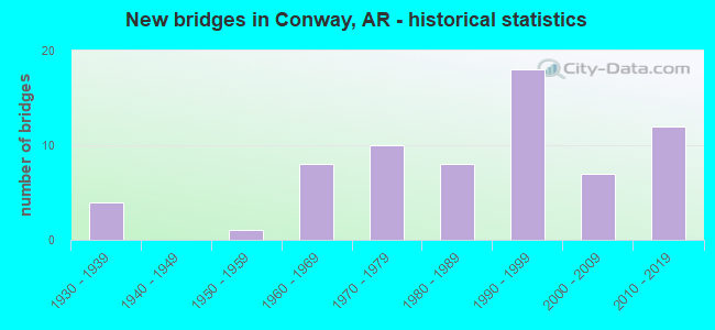
- New bridges - historical statistics
- 41930-1939
- 11950-1959
- 81960-1969
- 101970-1979
- 81980-1989
- 181990-1999
- 72000-2009
- 122010-2019
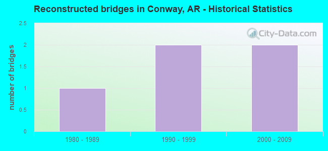
- Reconstructed bridges - Historical Statistics
- 11980-1989
- 21990-1999
- 22000-2009
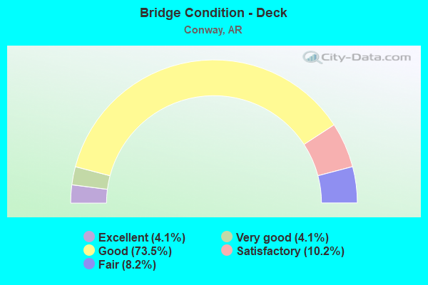
- Bridge Condition - Deck
- 4.1%Excellent
- 4.1%Very good
- 73.5%Good
- 10.2%Satisfactory
- 8.2%Fair
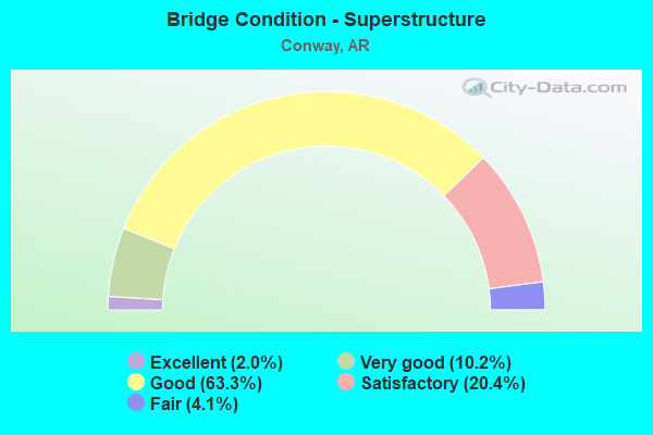
- Bridge Condition - Superstructure
- 2.0%Excellent
- 10.2%Very good
- 63.3%Good
- 20.4%Satisfactory
- 4.1%Fair
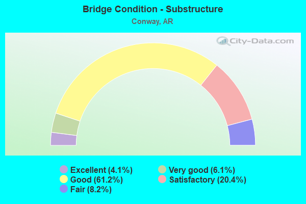
- Bridge Condition - Substructure
- 4.1%Excellent
- 6.1%Very good
- 61.2%Good
- 20.4%Satisfactory
- 8.2%Fair
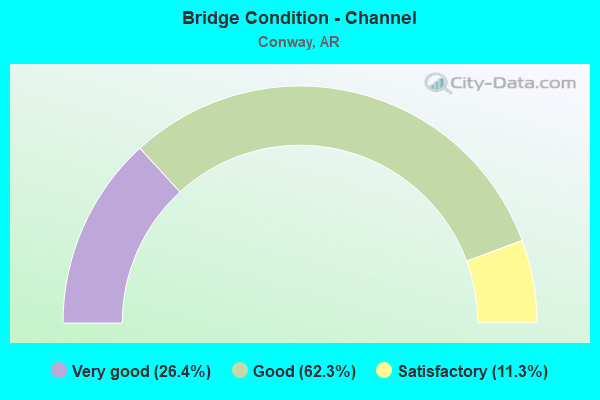
- Bridge Condition - Channel
- 26.4%Very good
- 62.3%Good
- 11.3%Satisfactory
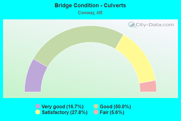
- Bridge Condition - Culverts
- 16.7%Very good
- 50.0%Good
- 27.8%Satisfactory
- 5.6%Fair
Find on map >> Show street view
Structure Number: 23229, Location: 0.15 M W Jct B.P. & Doneg (Lat: 35.076250, Lng: -92.456889), Route carried "on" structure: City street 46450, Year Built: 1991, Status: Open, Structure Length: 1.43m (4.69ft), Average Daily Traffic: 420 (year 2018), Truck Traffic: 1%, Average Future Daily Traffic: 1,450 (year 2028), Features Intersected: STONE DAM CREEK, Facility Carried by Structure: BEATRICE POWELL ST
Minimum Vertical Clearance: 30+ m (98+ ft), Kilometerpoint: 0.241, Lanes on structure: 2, Owner: State Agenciy, Approaching Roadway Width: 7.3m (24.0ft), Material/Design: Concrete, Design/Construction: Channel Beam, Number Of Spans In Main Unit: 2, Length of Maximum Span: 6.6m (21.7ft), Curb-To-Curb Width: 9.1m (29.9ft), Out-to-Out Width: 9.4m (30.8ft)
Condition: Deck: Good, Superstructure: Satisfactory, Substructure: Good, Channel: Very good, Operating Rating: 54.4 metric tons, Method Used To Determine Operating Rating: Load Factor (LF), Inventory Rating: 32.7 metric tons, Method Used To Determine Inventory Rating: Load Factor (LF), Structural Evaluation: Equal to present minimum criteria, Deck Geometry: Equal to present minimum criteria, Waterway Adequacy: Equal to present desirable criteria, Approach Roadway Alignment: Equal to present minimum criteria, Designated Inspection Frequency: Every 24 months, Critical Feature Inspection Frequency: Every 24 months, Inspection Date: January 2021, Deck Structure Type: Concrete Precast Panels, Wearing Surface/Protective System: Wearing Surface: Monolithic Concrete
Find on map >> Show street view
Structure Number: 23827, Location: 3.85 Mi. E. JCT. CR 904 (Lat: 35.074728, Lng: -92.333889), Route carried "on" structure: County highway 48, Year Built: 1985, Status: Posted for load, Structure Length: 2.72m (8.92ft), Average Daily Traffic: 3,323 (year 2018), Truck Traffic: 1%, Average Future Daily Traffic: 165 (year 2037), Features Intersected: Warren Creek, Facility Carried by Structure: Middle Rd
Minimum Vertical Clearance: 30.44m (99.87ft), Kilometerpoint: 6.196, Lanes on structure: 2, Owner: County Highway Agency, Approaching Roadway Width: 5.4m (17.7ft), Material/Design: Steel, Design/Construction: Orthotropic, Number Of Spans In Main Unit: 1, Length of Maximum Span: 22.8m (74.8ft), Curb-To-Curb Width: 6.1m (20.0ft), Out-to-Out Width: 6.4m (21.0ft)
Condition: Deck: Good, Superstructure: Satisfactory, Substructure: Good, Channel: Good, Operating Rating: 9.1 metric tons, Method Used To Determine Operating Rating: Field evaluation and documented engineering judgment, Inventory Rating: 4.5 metric tons, Method Used To Determine Inventory Rating: Field evaluation and documented engineering judgment, Structural Evaluation: High priority of corrective action, Deck Geometry: High priority of replacement, Waterway Adequacy: Better than present minimum criteria, Approach Roadway Alignment: Equal to present desirable criteria, Bridge Posting: Required (Relationship of Operating Rating to Maximum Legal Load: > 39.9% below), Designated Inspection Frequency: Every 24 months, Critical Feature Inspection Frequency: Every 24 months, Inspection Date: April 2021, Critical Feature Inspection Date: April 2021, Deck Structure Type: Steel plate, Wearing Surface/Protective System: Wearing Surface: Integral Concrete
Find on map >> Show street view
Structure Number: 23894, Location: 6.2MI W SH 89 (Lat: 34.995711, Lng: -92.581531), Route carried "on" structure: County highway 3, Year Built: 2019, Status: Open, Structure Length: 3.44m (11.29ft), Average Daily Traffic: 200 (year 2019), Truck Traffic: 1%, Average Future Daily Traffic: 240 (year 2040), Design Load: HL 93, Features Intersected: Tupelo Bayou, Facility Carried by Structure: Lollie Rd
Minimum Vertical Clearance: 30.44m (99.87ft), Kilometerpoint: 9.897, Lanes on structure: 2, Owner: County Highway Agency, Approaching Roadway Width: 7.4m (24.3ft), Material/Design: Concrete, Design/Construction: Channel Beam, Number Of Spans In Main Unit: 5, Length of Maximum Span: 9.4m (30.8ft), Curb-To-Curb Width: 9.1m (29.9ft), Out-to-Out Width: 9.4m (30.8ft)
Condition: Deck: Excellent, Superstructure: Very good, Substructure: Excellent, Channel: Very good, Operating Rating: 25.4 metric tons, Method Used To Determine Operating Rating: Load and Resistance Factor (LRFR), Inventory Rating: 20.0 metric tons, Method Used To Determine Inventory Rating: Load and Resistance Factor (LRFR), Structural Evaluation: Somewhat better than minimum adequacy, Deck Geometry: Equal to present minimum criteria, Waterway Adequacy: Equal to present desirable criteria, Approach Roadway Alignment: Better than present minimum criteria, Designated Inspection Frequency: Every 24 months, Critical Feature Inspection Frequency: Every 24 months, Inspection Date: June 2021, Deck Structure Type: Concrete Precast Panels, Wearing Surface/Protective System: Wearing Surface: Monolithic Concrete
Find on map >> Show street view
Structure Number: 23895, Location: 0.1 M N Jct US 64 & CR 46 (Lat: 35.087261, Lng: -92.348700), Route carried "on" structure: County highway 46, Year Built: 2016, Status: Open, Structure Length: 0.94m (3.08ft), Average Daily Traffic: 6,400 (year 2018), Truck Traffic: 1%, Average Future Daily Traffic: 115 (year 2036), Features Intersected: Bentley Creek, Facility Carried by Structure: Lower Ridge Rd
Minimum Vertical Clearance: 30+ m (98+ ft), Kilometerpoint: 0.177, Lanes on structure: 2, Owner: County Highway Agency, Approaching Roadway Width: 6.1m (20.0ft), Material/Design: Concrete, Design/Construction: Channel Beam, Number Of Spans In Main Unit: 1, Length of Maximum Span: 8.7m (28.5ft), Curb or Sidewalk Widths: Left: 0.2m (0.7ft), Right: 0.2m (0.7ft), Curb-To-Curb Width: 8.4m (27.6ft), Out-to-Out Width: 8.7m (28.5ft)
Condition: Deck: Good, Superstructure: Good, Substructure: Very good, Channel: Very good, Operating Rating: 54.4 metric tons, Method Used To Determine Operating Rating: Load Factor (LF), Inventory Rating: 32.7 metric tons, Method Used To Determine Inventory Rating: Load Factor (LF), Structural Evaluation: Better than present minimum criteria, Deck Geometry: High priority of replacement, Waterway Adequacy: Equal to present desirable criteria, Approach Roadway Alignment: Equal to present desirable criteria, Designated Inspection Frequency: Every 24 months, Critical Feature Inspection Frequency: Every 24 months, Inspection Date: August 2020, Deck Structure Type: Concrete Precast Panels, Wearing Surface/Protective System: Wearing Surface: Monolithic Concrete
Find on map >> Show street view
Structure Number: 23946, Location: .21 M. E. of Farris Rd. (Lat: 35.089858, Lng: -92.466300), Route carried "on" structure: City street 262, Year Built: 1997, Status: Posted for load, Structure Length: 1.05m (3.44ft), Average Daily Traffic: 305 (year 2018), Truck Traffic: 1%, Average Future Daily Traffic: 115 (year 2037), Features Intersected: Tucker Creek, Facility Carried by Structure: Adamsbrooke Dr.
Minimum Vertical Clearance: 30+ m (98+ ft), Kilometerpoint: 0.338, Lanes on structure: 2, Owner: City or Municipal Highway Agency, Approaching Roadway Width: 6.8m (22.3ft), Skew: 1 degrees, Material/Design: Steel, Design/Construction: Stringer/Multi-beam, Number Of Spans In Main Unit: 1, Length of Maximum Span: 10.5m (34.4ft), Curb or Sidewalk Widths: Left: 0.2m (0.7ft), Right: 0.2m (0.7ft), Curb-To-Curb Width: 7.5m (24.6ft), Out-to-Out Width: 7.9m (25.9ft)
Condition: Deck: Good, Superstructure: Very good, Substructure: Good, Channel: Good, Operating Rating: 22.7 metric tons, Method Used To Determine Operating Rating: Load Factor (LF), Inventory Rating: 13.6 metric tons, Method Used To Determine Inventory Rating: Load Factor (LF), Structural Evaluation: Meets minimum limits, Deck Geometry: Somewhat better than minimum adequacy, Waterway Adequacy: Equal to present minimum criteria, Approach Roadway Alignment: Equal to present minimum criteria, Bridge Posting: Required (Relationship of Operating Rating to Maximum Legal Load: > 39.9% below), Designated Inspection Frequency: Every 24 months, Critical Feature Inspection Frequency: Every 24 months, Inspection Date: April 2021, Deck Structure Type: Concrete Cast-file-Place, Wearing Surface/Protective System: Wearing Surface: Monolithic Concrete
Find on map >> Show street view
Structure Number: 23988, Location: 1.0 MI E OF I-40 (Lat: 35.054539, Lng: -92.399647), Route carried "on" structure: County highway 50, Year Built: 2018, Status: Not yet open, Structure Length: 3.78m (12.40ft), Average Daily Traffic: 2,994 (year 2018), Truck Traffic: 1%, Average Future Daily Traffic: 190 (year 2037), Design Load: HL 93, Features Intersected: Little Creek
Minimum Vertical Clearance: 30+ m (98+ ft), Kilometerpoint: 1.400, Lanes on structure: 2, Owner: County Highway Agency, Approaching Roadway Width: 7.3m (24.0ft), Material/Design: Concrete, Design/Construction: Channel Beam, Number Of Spans In Main Unit: 4, Length of Maximum Span: 8.6m (28.2ft), Curb or Sidewalk Widths: Left: 0.4m (1.3ft), Right: 0.4m (1.3ft), Curb-To-Curb Width: 8.5m (27.9ft), Out-to-Out Width: 9.3m (30.5ft)
Condition: Deck: Excellent, Superstructure: Very good, Substructure: Excellent, Channel: Very good, Operating Rating: 52.6 metric tons, Method Used To Determine Operating Rating: Load and Resistance Factor (LRFR), Inventory Rating: 32.7 metric tons, Method Used To Determine Inventory Rating: Load and Resistance Factor (LRFR), Structural Evaluation: Equal to present desirable criteria, Deck Geometry: Meets minimum limits, Waterway Adequacy: Equal to present desirable criteria, Approach Roadway Alignment: Equal to present minimum criteria, Designated Inspection Frequency: Every 24 months, Critical Feature Inspection Frequency: Every 24 months, Inspection Date: April 2020, Deck Structure Type: Concrete Precast Panels
Find on map >> Show street view
Structure Number: 32159, Location: 4.47 MI E TOAD SUCK DAM (Lat: 35.070347, Lng: -92.461669), Route carried "on" structure: State highway 60, Year Built: 1972, Year Reconstructed: 2004, Status: Open, Structure Length: 0.67m (2.20ft), Average Daily Traffic: 32,000 (year 2018), Truck Traffic: 1%, Average Future Daily Traffic: 46,400 (year 2038), Design Load: H 20, Features Intersected: Stone Dam Creek
Minimum Vertical Clearance: 30+ m (98+ ft), Kilometerpoint: 3.058, Lanes on structure: 2, Base Highway Network: Yes, Owner: State Highway Agency, Approaching Roadway Width: 9.8m (32.2ft), Skew: 4 degrees, Material/Design: Concrete, Design/Construction: Culvert, Number Of Spans In Main Unit: 2, Length of Maximum Span: 3.0m (9.8ft)
Condition: Channel: Good, Culverts: Good, Operating Rating: 49.9 metric tons, Method Used To Determine Operating Rating: Load Factor (LF), Inventory Rating: 29.9 metric tons, Method Used To Determine Inventory Rating: Load Factor (LF), Structural Evaluation: Better than present minimum criteria, Waterway Adequacy: Better than present minimum criteria, Approach Roadway Alignment: Equal to present desirable criteria, Designated Inspection Frequency: Every 48 months, Critical Feature Inspection Frequency: Every 24 months, Inspection Date: September 2018
Find on map >> Show street view
Structure Number: A3919, Location: 4.05 MI E CONWAY CO LINE (Lat: 35.115950, Lng: -92.448169), Route carried "on" structure: Interstate 40, Year Built: 1966, Status: Open, Structure Length: 5.18m (16.99ft), Average Daily Traffic: 10,000 (year 2018), Truck Traffic: 1%, Average Future Daily Traffic: 23,927 (year 2028), Design Load: HS 20+Mod, Features Intersected: Friendship Rd.
Minimum Vertical Clearance: 30+ m (98+ ft), Kilometerpoint: 200.106, Lanes on structure: 2, Lanes under structure: 2, Base Highway Network: Yes, Owner: State Highway Agency, Approaching Roadway Width: 12.2m (40.0ft), Material/Design: Steel, Design/Construction: Stringer/Multi-beam, Number Of Spans In Main Unit: 3, Length of Maximum Span: 17.1m (56.1ft), Curb-To-Curb Width: 11.8m (38.7ft), Out-to-Out Width: 13.0m (42.7ft)
Condition: Deck: Very good, Superstructure: Satisfactory, Substructure: Satisfactory, Operating Rating: 54.4 metric tons, Method Used To Determine Operating Rating: Load Factor (LF), Inventory Rating: 32.7 metric tons, Method Used To Determine Inventory Rating: Load Factor (LF), Structural Evaluation: Equal to present minimum criteria, Deck Geometry: Equal to present minimum criteria, Underclear: High priority of corrective action, Approach Roadway Alignment: Equal to present desirable criteria, Designated Inspection Frequency: Every 24 months, Critical Feature Inspection Frequency: Every 24 months, Inspection Date: Febuary 2022, Deck Structure Type: Concrete Cast-file-Place, Wearing Surface/Protective System: Wearing Surface: Monolithic Concrete
Find on map >> Show street view
Structure Number: A6428, Location: FAULKNER CO LINE (Lat: 35.131189, Lng: -92.515258), Route carried "on" structure: Interstate 40, Year Built: 1992, Status: Open, Structure Length: 15.45m (50.69ft), Average Daily Traffic: 24,633 (year 2010), Truck Traffic: 1%, Average Future Daily Traffic: 20,561 (year 2028), Design Load: HS 20, Features Intersected: Cadron Creek
Minimum Vertical Clearance: 30+ m (98+ ft), Kilometerpoint: 193.427, Lanes on structure: 2, Base Highway Network: Yes, Owner: State Highway Agency, Approaching Roadway Width: 12.2m (40.0ft), Skew: 2 degrees, Material/Design: Steel continuous, Design/Construction: Stringer/Multi-beam, Number Of Spans In Main Unit: 5, Length of Maximum Span: 35.1m (115.2ft), Curb-To-Curb Width: 12.2m (40.0ft), Out-to-Out Width: 13.0m (42.7ft)
Condition: Deck: Satisfactory, Superstructure: Good, Substructure: Good, Channel: Very good, Operating Rating: 54.4 metric tons, Method Used To Determine Operating Rating: Load Factor (LF), Inventory Rating: 32.7 metric tons, Method Used To Determine Inventory Rating: Load Factor (LF), Structural Evaluation: Better than present minimum criteria, Deck Geometry: Better than present minimum criteria, Waterway Adequacy: Equal to present desirable criteria, Approach Roadway Alignment: Equal to present desirable criteria, Designated Inspection Frequency: Every 24 months, Critical Feature Inspection Frequency: Every 24 months, Inspection Date: January 2021, Deck Structure Type: Concrete Cast-file-Place, Wearing Surface/Protective System: Wearing Surface: Monolithic Concrete, Deck Protection: Epoxy Coated Reinforcing
Find on map >> Show street view
Structure Number: A6869, Location: JCT I 40 & US 65 (Lat: 35.112181, Lng: -92.435500), Route carried "on" structure: Interstate 40, Year Built: 2003, Status: Open, Structure Length: 10.55m (34.61ft), Average Daily Traffic: 20,000 (year 2018), Truck Traffic: 16%, Average Future Daily Traffic: 37,704 (year 2028), Design Load: HS 20, Features Intersected: US 65-SEC 9
Minimum Vertical Clearance: 30+ m (98+ ft), Kilometerpoint: 201.345, Lanes on structure: 2, Lanes under structure: 5, Base Highway Network: Yes, Owner: State Highway Agency, Approaching Roadway Width: 12.2m (40.0ft), Skew: 4 degrees, Material/Design: Steel continuous, Design/Construction: Stringer/Multi-beam, Number Of Spans In Main Unit: 4, Length of Maximum Span: 30.2m (99.1ft), Curb-To-Curb Width: 12.2m (40.0ft), Out-to-Out Width: 13.1m (43.0ft)
Condition: Deck: Good, Superstructure: Good, Substructure: Good, Operating Rating: 54.4 metric tons, Method Used To Determine Operating Rating: Load Factor (LF), Inventory Rating: 32.7 metric tons, Method Used To Determine Inventory Rating: Load Factor (LF), Structural Evaluation: Better than present minimum criteria, Deck Geometry: Better than present minimum criteria, Underclear: Meets minimum limits, Approach Roadway Alignment: Equal to present desirable criteria, Designated Inspection Frequency: Every 24 months, Critical Feature Inspection Frequency: Every 24 months, Inspection Date: December 2021, Deck Structure Type: Concrete Cast-file-Place, Wearing Surface/Protective System: Wearing Surface: Monolithic Concrete, Deck Protection: Epoxy Coated Reinforcing
Find on map >> Show street view
Structure Number: A6883, Location: 1.5 mi S of Conway (Lat: 35.050289, Lng: -92.414239), Route carried "on" structure: Interstate 40, Year Built: 2013, Status: Open, Structure Length: 2.99m (9.81ft), Average Daily Traffic: 35,000 (year 2018), Truck Traffic: 20%, Average Future Daily Traffic: 42,000 (year 2031), Design Load: HS 20+Mod, Features Intersected: Stone Dam Creek
Minimum Vertical Clearance: 30+ m (98+ ft), Kilometerpoint: 209.022, Lanes on structure: 3, Base Highway Network: Yes, Owner: State Highway Agency, Approaching Roadway Width: 17.1m (56.1ft), Material/Design: Concrete continuous, Design/Construction: Slab, Number Of Spans In Main Unit: 3, Length of Maximum Span: 10.4m (34.1ft), Curb-To-Curb Width: 17.1m (56.1ft), Out-to-Out Width: 18.0m (59.1ft)
Condition: Deck: Good, Superstructure: Good, Substructure: Good, Channel: Very good, Operating Rating: 54.4 metric tons, Method Used To Determine Operating Rating: Load Factor (LF), Inventory Rating: 32.7 metric tons, Method Used To Determine Inventory Rating: Load Factor (LF), Structural Evaluation: Better than present minimum criteria, Deck Geometry: Equal to present minimum criteria, Waterway Adequacy: Equal to present desirable criteria, Approach Roadway Alignment: Superior to present desirable criteria, Designated Inspection Frequency: Every 24 months, Critical Feature Inspection Frequency: Every 24 months, Inspection Date: Febuary 2022, Deck Structure Type: Concrete Cast-file-Place, Wearing Surface/Protective System: Wearing Surface: Monolithic Concrete, Deck Protection: Epoxy Coated Reinforcing
Find on map >> Show street view
Structure Number: A6884, Location: 2.95 Mi S US 65B (Lat: 35.024078, Lng: -92.409308), Route carried "on" structure: Interstate 40, Year Built: 2012, Status: Open, Structure Length: 6.89m (22.60ft), Average Daily Traffic: 8,500 (year 2018), Truck Traffic: 20%, Average Future Daily Traffic: 41,500 (year 2030), Design Load: HS 20+Mod, Features Intersected: Gold Creek
Minimum Vertical Clearance: 30+ m (98+ ft), Kilometerpoint: 211.935, Lanes on structure: 3, Base Highway Network: Yes, Owner: State Highway Agency, Approaching Roadway Width: 17.1m (56.1ft), Material/Design: Concrete continuous, Design/Construction: Slab, Number Of Spans In Main Unit: 7, Length of Maximum Span: 10.4m (34.1ft), Curb-To-Curb Width: 17.1m (56.1ft), Out-to-Out Width: 18.0m (59.1ft)
Condition: Deck: Good, Superstructure: Good, Substructure: Good, Channel: Good, Operating Rating: 54.4 metric tons, Method Used To Determine Operating Rating: Load Factor (LF), Inventory Rating: 32.7 metric tons, Method Used To Determine Inventory Rating: Load Factor (LF), Structural Evaluation: Better than present minimum criteria, Deck Geometry: Equal to present minimum criteria, Waterway Adequacy: Equal to present desirable criteria, Approach Roadway Alignment: Equal to present desirable criteria, Designated Inspection Frequency: Every 24 months, Critical Feature Inspection Frequency: Every 24 months, Inspection Date: September 2020, Deck Structure Type: Concrete Cast-file-Place, Wearing Surface/Protective System: Wearing Surface: Monolithic Concrete, Deck Protection: Epoxy Coated Reinforcing
Find on map >> Show street view
Structure Number: B3919, Location: 4.05 MI E CONWAY CO LINE (Lat: 35.115781, Lng: -92.448381), Route carried "on" structure: Interstate 40, Year Built: 1966, Status: Open, Structure Length: 5.18m (16.99ft), Average Daily Traffic: 10,000 (year 2018), Truck Traffic: 1%, Average Future Daily Traffic: 53,600 (year 2038), Design Load: HS 20+Mod, Features Intersected: Friendship Rd.
Minimum Vertical Clearance: 30+ m (98+ ft), Kilometerpoint: 200.106, Lanes on structure: 2, Lanes under structure: 2, Base Highway Network: Yes, Owner: State Highway Agency, Approaching Roadway Width: 12.2m (40.0ft), Material/Design: Steel, Design/Construction: Stringer/Multi-beam, Number Of Spans In Main Unit: 3, Length of Maximum Span: 17.1m (56.1ft), Curb-To-Curb Width: 11.7m (38.4ft), Out-to-Out Width: 13.0m (42.7ft)
Condition: Deck: Very good, Superstructure: Satisfactory, Substructure: Satisfactory, Operating Rating: 54.4 metric tons, Method Used To Determine Operating Rating: Load Factor (LF), Inventory Rating: 32.7 metric tons, Method Used To Determine Inventory Rating: Load Factor (LF), Structural Evaluation: Equal to present minimum criteria, Deck Geometry: Equal to present minimum criteria, Underclear: High priority of corrective action, Approach Roadway Alignment: Equal to present desirable criteria, Designated Inspection Frequency: Every 24 months, Critical Feature Inspection Frequency: Every 24 months, Inspection Date: Febuary 2022, Deck Structure Type: Concrete Cast-file-Place, Wearing Surface/Protective System: Wearing Surface: Monolithic Concrete
Find on map >> Show street view
Structure Number: B6428, Location: FAULKNER CO LINE (Lat: 35.130981, Lng: -92.515392), Route carried "on" structure: Interstate 40, Year Built: 1992, Status: Open, Structure Length: 15.45m (50.69ft), Average Daily Traffic: 24,633 (year 2010), Truck Traffic: 1%, Average Future Daily Traffic: 20,561 (year 2028), Design Load: HS 20, Features Intersected: Cadron Creek
Minimum Vertical Clearance: 30+ m (98+ ft), Kilometerpoint: 193.427, Lanes on structure: 2, Base Highway Network: Yes, Owner: State Highway Agency, Approaching Roadway Width: 12.2m (40.0ft), Skew: 2 degrees, Material/Design: Steel continuous, Design/Construction: Stringer/Multi-beam, Number Of Spans In Main Unit: 5, Length of Maximum Span: 35.1m (115.2ft), Curb-To-Curb Width: 12.2m (40.0ft), Out-to-Out Width: 13.0m (42.7ft)
Condition: Deck: Satisfactory, Superstructure: Good, Substructure: Good, Channel: Good, Operating Rating: 54.4 metric tons, Method Used To Determine Operating Rating: Load Factor (LF), Inventory Rating: 32.7 metric tons, Method Used To Determine Inventory Rating: Load Factor (LF), Structural Evaluation: Better than present minimum criteria, Deck Geometry: Better than present minimum criteria, Waterway Adequacy: Equal to present desirable criteria, Approach Roadway Alignment: Equal to present desirable criteria, Designated Inspection Frequency: Every 24 months, Critical Feature Inspection Frequency: Every 24 months, Inspection Date: January 2021, Deck Structure Type: Concrete Cast-file-Place, Wearing Surface/Protective System: Wearing Surface: Monolithic Concrete
Find on map >> Show street view
Structure Number: B6869, Location: JCT I 40 & US 65 (Lat: 35.112111, Lng: -92.436111), Route carried "on" structure: Interstate 40, Year Built: 2004, Status: Open, Structure Length: 11.09m (36.38ft), Average Daily Traffic: 20,000 (year 2018), Truck Traffic: 16%, Average Future Daily Traffic: 53,600 (year 2038), Design Load: HS 20+Mod, Features Intersected: US 65-SEC 9
Minimum Vertical Clearance: 30+ m (98+ ft), Kilometerpoint: 201.345, Lanes on structure: 2, Lanes under structure: 5, Base Highway Network: Yes, Owner: State Highway Agency, Approaching Roadway Width: 12.2m (40.0ft), Skew: 4 degrees, Material/Design: Steel continuous, Design/Construction: Stringer/Multi-beam, Number Of Spans In Main Unit: 4, Length of Maximum Span: 32.0m (105.0ft), Curb-To-Curb Width: 12.2m (40.0ft), Out-to-Out Width: 13.1m (43.0ft)
Condition: Deck: Good, Superstructure: Good, Substructure: Good, Operating Rating: 54.4 metric tons, Method Used To Determine Operating Rating: Load Factor (LF), Inventory Rating: 32.7 metric tons, Method Used To Determine Inventory Rating: Load Factor (LF), Structural Evaluation: Better than present minimum criteria, Deck Geometry: Better than present minimum criteria, Underclear: Somewhat better than minimum adequacy, Approach Roadway Alignment: Equal to present desirable criteria, Designated Inspection Frequency: Every 24 months, Critical Feature Inspection Frequency: Every 24 months, Inspection Date: December 2021, Deck Structure Type: Concrete Cast-file-Place, Wearing Surface/Protective System: Wearing Surface: Monolithic Concrete, Deck Protection: Epoxy Coated Reinforcing
Find on map >> Show street view
Structure Number: B6883, Location: 1.5 mi S of Conway (Lat: 35.050250, Lng: -92.414469), Route carried "on" structure: Interstate 40, Year Built: 2013, Status: Open, Structure Length: 2.99m (9.81ft), Average Daily Traffic: 35,000 (year 2018), Truck Traffic: 15%, Average Future Daily Traffic: 42,000 (year 2031), Design Load: HL 93, Features Intersected: Stone Dam Creek
Minimum Vertical Clearance: 30+ m (98+ ft), Kilometerpoint: 209.022, Lanes on structure: 3, Base Highway Network: Yes, Owner: State Highway Agency, Approaching Roadway Width: 17.1m (56.1ft), Material/Design: Concrete continuous, Design/Construction: Slab, Number Of Spans In Main Unit: 3, Length of Maximum Span: 10.4m (34.1ft), Curb-To-Curb Width: 17.1m (56.1ft), Out-to-Out Width: 18.0m (59.1ft)
Condition: Deck: Good, Superstructure: Good, Substructure: Good, Channel: Very good, Operating Rating: 54.4 metric tons, Method Used To Determine Operating Rating: Load Factor (LF), Inventory Rating: 32.7 metric tons, Method Used To Determine Inventory Rating: Load Factor (LF), Structural Evaluation: Better than present minimum criteria, Deck Geometry: Equal to present minimum criteria, Waterway Adequacy: Equal to present desirable criteria, Approach Roadway Alignment: Superior to present desirable criteria, Designated Inspection Frequency: Every 24 months, Critical Feature Inspection Frequency: Every 24 months, Inspection Date: Febuary 2022, Deck Structure Type: Concrete Cast-file-Place, Wearing Surface/Protective System: Wearing Surface: Monolithic Concrete, Deck Protection: Epoxy Coated Reinforcing
Find on map >> Show street view
Structure Number: B6884, Location: 2.95 Mi S US 65B (Lat: 35.024097, Lng: -92.409589), Route carried "on" structure: Interstate 40, Year Built: 2012, Status: Open, Structure Length: 6.89m (22.60ft), Average Daily Traffic: 8,500 (year 2018), Truck Traffic: 15%, Average Future Daily Traffic: 41,500 (year 2030), Design Load: HS 20+Mod, Features Intersected: Gold Creek
Minimum Vertical Clearance: 30+ m (98+ ft), Kilometerpoint: 211.935, Lanes on structure: 3, Base Highway Network: Yes, Owner: State Highway Agency, Approaching Roadway Width: 17.1m (56.1ft), Material/Design: Concrete continuous, Design/Construction: Slab, Number Of Spans In Main Unit: 7, Length of Maximum Span: 10.4m (34.1ft), Curb-To-Curb Width: 17.1m (56.1ft), Out-to-Out Width: 18.0m (59.1ft)
Condition: Deck: Good, Superstructure: Good, Substructure: Very good, Channel: Good, Operating Rating: 54.4 metric tons, Method Used To Determine Operating Rating: Load Factor (LF), Inventory Rating: 32.7 metric tons, Method Used To Determine Inventory Rating: Load Factor (LF), Structural Evaluation: Better than present minimum criteria, Deck Geometry: Equal to present minimum criteria, Waterway Adequacy: Equal to present desirable criteria, Approach Roadway Alignment: Equal to present desirable criteria, Designated Inspection Frequency: Every 24 months, Critical Feature Inspection Frequency: Every 24 months, Inspection Date: September 2020, Deck Structure Type: Concrete Cast-file-Place, Wearing Surface/Protective System: Wearing Surface: Monolithic Concrete, Deck Protection: Epoxy Coated Reinforcing
Find on map >> Show street view
Structure Number: M2615, Location: 0.56 MI E JCT US 65 & 266 (Lat: 35.098997, Lng: -92.428739), Route carried "on" structure: State highway 266, Year Built: 1967, Status: Open, Structure Length: 0.79m (2.59ft), Average Daily Traffic: 10,000 (year 2018), Truck Traffic: 2%, Average Future Daily Traffic: 15,952 (year 2028), Features Intersected: DITCH
Minimum Vertical Clearance: 30+ m (98+ ft), Kilometerpoint: 0.901, Lanes on structure: 2, Owner: State Highway Agency, Approaching Roadway Width: 8.5m (27.9ft), Skew: 3 degrees, Material/Design: Concrete, Design/Construction: Culvert, Number Of Spans In Main Unit: 2, Length of Maximum Span: 3.4m (11.2ft)
Condition: Channel: Good, Culverts: Satisfactory, Operating Rating: 42.6 metric tons, Method Used To Determine Operating Rating: Load Factor (LF), Inventory Rating: 25.4 metric tons, Method Used To Determine Inventory Rating: Load Factor (LF), Structural Evaluation: Equal to present minimum criteria, Waterway Adequacy: Equal to present desirable criteria, Approach Roadway Alignment: Equal to present desirable criteria, Designated Inspection Frequency: Every 48 months, Critical Feature Inspection Frequency: Every 24 months, Inspection Date: Febuary 2020
Find on map >> Show street view
Structure Number: M3374, Location: 2.3 MI NE INT US 64 & I40 (Lat: 35.125119, Lng: -92.401728), Route carried "on" structure: City street 20, Year Built: 1967, Status: Open, Structure Length: 0.91m (2.99ft), Average Daily Traffic: 230 (year 2018), Truck Traffic: 3%, Average Future Daily Traffic: 300 (year 2038), Design Load: H 15, Features Intersected: Ditch
Minimum Vertical Clearance: 30+ m (98+ ft), Kilometerpoint: 0.016, Lanes on structure: 2, Owner: State Highway Agency, Approaching Roadway Width: 7.6m (24.9ft), Material/Design: Concrete, Design/Construction: Channel Beam, Number Of Spans In Main Unit: 2, Length of Maximum Span: 4.6m (15.1ft), Curb-To-Curb Width: 7.3m (24.0ft), Out-to-Out Width: 8.1m (26.6ft)
Condition: Deck: Good, Superstructure: Good, Substructure: Good, Channel: Good, Operating Rating: 54.4 metric tons, Method Used To Determine Operating Rating: Load Factor (LF), Inventory Rating: 32.7 metric tons, Method Used To Determine Inventory Rating: Load Factor (LF), Structural Evaluation: Better than present minimum criteria, Deck Geometry: Somewhat better than minimum adequacy, Waterway Adequacy: Equal to present desirable criteria, Approach Roadway Alignment: Meets minimum limits, Designated Inspection Frequency: Every 24 months, Critical Feature Inspection Frequency: Every 24 months, Inspection Date: September 2020, Deck Structure Type: Concrete Precast Panels, Wearing Surface/Protective System: Wearing Surface: Monolithic Concrete
Find on map >> Show street view
Structure Number: X0138, Location: 2.0 MI E CONWAY CO LINE (Lat: 35.120350, Lng: -92.483911), Route carried "on" structure: Interstate 40, Year Built: 1967, Status: Open, Structure Length: 0.79m (2.59ft), Average Daily Traffic: 36,000 (year 2018), Truck Traffic: 26%, Average Future Daily Traffic: 48,200 (year 2038), Design Load: H 20, Features Intersected: DITCH
Minimum Vertical Clearance: 30+ m (98+ ft), Kilometerpoint: 196.775, Lanes on structure: 4, Base Highway Network: Yes, Owner: State Highway Agency, Approaching Roadway Width: 30.2m (99.1ft), Skew: 23 degrees, Material/Design: Concrete, Design/Construction: Culvert, Number Of Spans In Main Unit: 2, Length of Maximum Span: 4.0m (13.1ft)
Condition: Channel: Good, Culverts: Satisfactory, Operating Rating: 26.3 metric tons, Method Used To Determine Operating Rating: Load Factor (LF), Inventory Rating: 16.3 metric tons, Method Used To Determine Inventory Rating: Load Factor (LF), Structural Evaluation: Meets minimum limits, Waterway Adequacy: Equal to present desirable criteria, Approach Roadway Alignment: Superior to present desirable criteria, Designated Inspection Frequency: Every 48 months, Critical Feature Inspection Frequency: Every 24 months, Inspection Date: Febuary 2020
Find on map >> Show street view
Structure Number: X0139, Location: 0.25 MI NW SH 266 UNDERPS (Lat: 35.101381, Lng: -92.432131), Route carried "on" structure: Interstate 40, Year Built: 1967, Status: Open, Structure Length: 0.76m (2.49ft), Average Daily Traffic: 64,000 (year 2018), Truck Traffic: 16%, Average Future Daily Traffic: 85,700 (year 2038), Design Load: H 20, Features Intersected: Ditch
Minimum Vertical Clearance: 30+ m (98+ ft), Kilometerpoint: 202.665, Lanes on structure: 4, Base Highway Network: Yes, Owner: State Highway Agency, Approaching Roadway Width: 30.2m (99.1ft), Skew: 24 degrees, Material/Design: Concrete, Design/Construction: Culvert, Number Of Spans In Main Unit: 2, Length of Maximum Span: 3.7m (12.1ft)
Condition: Channel: Good, Culverts: Good, Operating Rating: 50.8 metric tons, Method Used To Determine Operating Rating: Load Factor (LF), Inventory Rating: 30.8 metric tons, Method Used To Determine Inventory Rating: Load Factor (LF), Structural Evaluation: Better than present minimum criteria, Waterway Adequacy: Better than present minimum criteria, Approach Roadway Alignment: Equal to present desirable criteria, Designated Inspection Frequency: Every 48 months, Critical Feature Inspection Frequency: Every 24 months, Inspection Date: Febuary 2020
Find on map >> Show street view
Structure Number: X0149, Location: 0.7 MI W OF FAULKNER CO L (Lat: 35.075750, Lng: -92.553550), Route carried "on" structure: State highway 60, Year Built: 1970, Status: Open, Structure Length: 1.01m (3.31ft), Average Daily Traffic: 5,826 (year 2018), Truck Traffic: 2%, Average Future Daily Traffic: 6,597 (year 2028), Design Load: H 20, Features Intersected: Ouachita Creek
Minimum Vertical Clearance: 30+ m (98+ ft), Kilometerpoint: 0.724, Lanes on structure: 2, Base Highway Network: Yes, Owner: State Highway Agency, Approaching Roadway Width: 8.5m (27.9ft), Material/Design: Concrete, Design/Construction: Culvert, Number Of Spans In Main Unit: 3, Length of Maximum Span: 3.0m (9.8ft)
Condition: Channel: Good, Culverts: Fair, Operating Rating: 26.3 metric tons, Method Used To Determine Operating Rating: Load Factor (LF), Inventory Rating: 16.3 metric tons, Method Used To Determine Inventory Rating: Load Factor (LF), Structural Evaluation: Meets minimum limits, Waterway Adequacy: Equal to present desirable criteria, Approach Roadway Alignment: Equal to present minimum criteria, Designated Inspection Frequency: Every 24 months, Critical Feature Inspection Frequency: Every 24 months, Inspection Date: July 2020
Find on map >> Show street view
Structure Number: X0181, Location: 4.5 MI E TOAD SUCK DAM (Lat: 35.070328, Lng: -92.461139), Route carried "on" structure: State highway 60, Year Built: 1972, Year Reconstructed: 2004, Status: Open, Structure Length: 0.79m (2.59ft), Average Daily Traffic: 32,000 (year 2018), Truck Traffic: 1%, Average Future Daily Traffic: 46,400 (year 2038), Design Load: H 20, Features Intersected: Stone Dam Creek
Minimum Vertical Clearance: 30+ m (98+ ft), Kilometerpoint: 3.026, Lanes on structure: 2, Base Highway Network: Yes, Owner: State Highway Agency, Approaching Roadway Width: 9.8m (32.2ft), Material/Design: Concrete, Design/Construction: Culvert, Number Of Spans In Main Unit: 3, Length of Maximum Span: 2.4m (7.9ft)
Condition: Channel: Good, Culverts: Good, Operating Rating: 47.2 metric tons, Method Used To Determine Operating Rating: Load Factor (LF), Inventory Rating: 28.1 metric tons, Method Used To Determine Inventory Rating: Load Factor (LF), Structural Evaluation: Better than present minimum criteria, Waterway Adequacy: Better than present minimum criteria, Approach Roadway Alignment: Equal to present desirable criteria, Designated Inspection Frequency: Every 48 months, Critical Feature Inspection Frequency: Every 24 months, Inspection Date: September 2018
Find on map >> Show street view
Structure Number: X0182, Location: 6.2 MI E TOAD SUCK DAM (Lat: 35.066458, Lng: -92.432578), Route carried "on" structure: State highway 60, Year Built: 1972, Status: Open, Structure Length: 0.76m (2.49ft), Average Daily Traffic: 34,000 (year 2018), Truck Traffic: 1%, Average Future Daily Traffic: 5,656 (year 2028), Design Load: H 20, Features Intersected: Drainage Ditch
Minimum Vertical Clearance: 30+ m (98+ ft), Kilometerpoint: 0.257, Lanes on structure: 2, Base Highway Network: Yes, Owner: State Highway Agency, Approaching Roadway Width: 21.3m (69.9ft), Material/Design: Concrete, Design/Construction: Culvert, Number Of Spans In Main Unit: 2, Length of Maximum Span: 3.7m (12.1ft)
Condition: Channel: Good, Culverts: Good, Operating Rating: 31.8 metric tons, Method Used To Determine Operating Rating: Load Factor (LF), Inventory Rating: 19.1 metric tons, Method Used To Determine Inventory Rating: Load Factor (LF), Structural Evaluation: Meets minimum limits, Waterway Adequacy: Equal to present desirable criteria, Approach Roadway Alignment: Equal to present desirable criteria, Designated Inspection Frequency: Every 48 months, Critical Feature Inspection Frequency: Every 24 months, Inspection Date: September 2018
Find on map >> Show street view
Structure Number: X0592, Location: 2.42 MI N of HWY. 64 (Lat: 35.144289, Lng: -92.445619), Route carried "on" structure: State highway 25, Year Built: 1986, Status: Open, Structure Length: 1.68m (5.51ft), Average Daily Traffic: 7,600 (year 2018), Truck Traffic: 1%, Average Future Daily Traffic: 6,381 (year 2028), Design Load: H 20, Features Intersected: Beaver Fork Spillway
Minimum Vertical Clearance: 30+ m (98+ ft), Kilometerpoint: 3.895, Lanes on structure: 2, Owner: State Highway Agency, Approaching Roadway Width: 9.4m (30.8ft), Material/Design: Concrete, Design/Construction: Culvert, Number Of Spans In Main Unit: 5, Length of Maximum Span: 3.4m (11.2ft)
Condition: Channel: Good, Culverts: Very good, Operating Rating: 42.6 metric tons, Method Used To Determine Operating Rating: Load Factor (LF), Inventory Rating: 25.4 metric tons, Method Used To Determine Inventory Rating: Load Factor (LF), Structural Evaluation: Equal to present minimum criteria, Waterway Adequacy: Equal to present desirable criteria, Approach Roadway Alignment: Equal to present minimum criteria, Designated Inspection Frequency: Every 48 months, Critical Feature Inspection Frequency: Every 24 months, Inspection Date: September 2021
Find on map >> Show street view
Structure Number: X1514, Location: E Side of I-40 LM 127.4 (Lat: 35.083903, Lng: -92.413333), Route carried "on" structure: City street 64530, Year Built: 2016, Status: Open, Structure Length: 33.53m (110.01ft), Average Daily Traffic: 5,500 (year 2018), Truck Traffic: 4%, Average Future Daily Traffic: 10,242 (year 2036), Design Load: HL 93, Features Intersected: Creek, Facility Carried by Structure: 6th Street Conway
Minimum Vertical Clearance: 30.44m (99.87ft), Kilometerpoint: 2.028, Lanes on structure: 4, Owner: State Highway Agency, Approaching Roadway Width: 13.4m (44.0ft), Skew: 3 degrees, Material/Design: Concrete, Design/Construction: Culvert, Number Of Spans In Main Unit: 2, Length of Maximum Span: 3.4m (11.2ft)
Condition: Channel: Very good, Culverts: Good, Operating Rating: 54.4 metric tons, Method Used To Determine Operating Rating: Load and Resistance Factor (LRFR), Inventory Rating: 32.7 metric tons, Method Used To Determine Inventory Rating: Load and Resistance Factor (LRFR), Structural Evaluation: Better than present minimum criteria, Waterway Adequacy: Equal to present desirable criteria, Approach Roadway Alignment: Equal to present desirable criteria, Designated Inspection Frequency: Every 24 months, Critical Feature Inspection Frequency: Every 24 months, Inspection Date: Febuary 2022
Find on map >> Show street view
Structure Number: 3784, Location: 2.84 MI SOUTH OF SH 286 (Lat: 35.026050, Lng: -92.409161), Route carried "under" structure: Interstate 40, Structure Length: 0. m, Average Daily Traffic: 26,500 (year 2013), Truck Traffic: 20%, Features Intersected: I 40-SEC 32, Facility Carried by Structure: Brannon Landing Rd
Minimum Vertical Clearance: 5.02m (16.47ft), Kilometerpoint: 211.758, Length of Maximum Span: 0.0m
Find on map >> Show street view
Structure Number: 3784, Location: 2.84 MI SOUTH OF SH 286 (Lat: 35.026050, Lng: -92.409161), Route carried "under" structure: Interstate 40, Structure Length: 0. m, Average Daily Traffic: 26,500 (year 2013), Truck Traffic: 20%, Features Intersected: I 40-SEC 32, Facility Carried by Structure: Brannon Landing Rd
Minimum Vertical Clearance: 5.08m (16.67ft), Kilometerpoint: 211.758, Length of Maximum Span: 0.0m
Find on map >> Show street view
Structure Number: 3921, Location: 0.49 MI E JCT US 65B (Lat: 35.099039, Lng: -92.430739), Route carried "under" structure: Interstate 40, Structure Length: 0. m, Average Daily Traffic: 29,000 (year 2013), Truck Traffic: 1%, Features Intersected: I 40-SEC 32, Facility Carried by Structure: SH 266
Minimum Vertical Clearance: 4.93m (16.17ft), Kilometerpoint: 202.943, Length of Maximum Span: 0.0m
Find on map >> Show street view
Structure Number: 3921, Location: 0.49 MI E JCT US 65B (Lat: 35.099039, Lng: -92.430739), Route carried "under" structure: Interstate 40, Structure Length: 0. m, Average Daily Traffic: 29,000 (year 2013), Truck Traffic: 1%, Features Intersected: I 40-SEC 32, Facility Carried by Structure: SH 266
Minimum Vertical Clearance: 4.87m (15.98ft), Kilometerpoint: 202.987, Length of Maximum Span: 0.0m
Find on map >> Show street view
Structure Number: 5279, Location: 7 MI WEST OF CONWAY (Lat: 35.077917, Lng: -92.545889), Route carried "under" structure: County highway 72, Year Built: 1970, Structure Length: 0. m, Average Daily Traffic: 5,500 (year 2019), Truck Traffic: 1%, Features Intersected: CO RD 72
Minimum Vertical Clearance: 4.72m (15.49ft), Kilometerpoint: 0.402, Lanes on structure: 2, Lanes under structure: 2, Material/Design: Prestressed concrete, Design/Construction: Girder and Floorbeam System, Length of Maximum Span: 48.8m (160.1ft)
Find on map >> Show street view
Structure Number: 5787, Location: HENDRIX COL., CONWAY ARK (Lat: 35.101222, Lng: -92.440167), Route carried "under" structure: Business US 65, Structure Length: 0. m, Average Daily Traffic: 14,000 (year 2014), Truck Traffic: 1%, Features Intersected: US 65-SEC 9/B, Facility Carried by Structure: HENDRIX COL PED CR
Minimum Vertical Clearance: 4.94m (16.21ft), Kilometerpoint: 1.497, Length of Maximum Span: 0.0m
Find on map >> Show street view
Structure Number: 5787, Location: HENDRIX COL., CONWAY ARK (Lat: 35.101222, Lng: -92.440167), Route carried "under" structure: Business US 65, Structure Length: 0. m, Average Daily Traffic: 14,000 (year 2014), Truck Traffic: 1%, Features Intersected: US 65-SEC 9/B, Facility Carried by Structure: HENDRIX COL PED CR
Minimum Vertical Clearance: 4.92m (16.14ft), Kilometerpoint: 1.497, Length of Maximum Span: 0.0m
Find on map >> Show street view
Structure Number: 6583, Location: JCT US 65B SH 365 (Lat: 35.066733, Lng: -92.429925), Route carried "under" structure: City street 4510, Structure Length: 0. m, Average Daily Traffic: 12,000 (year 2002), Truck Traffic: 1%, Features Intersected: US65B, RRBent.-Sevr. Rd, Facility Carried by Structure: SH 60
Minimum Vertical Clearance: 6.55m (21.49ft), Kilometerpoint: 0.161, Length of Maximum Span: 0.0m
Find on map >> Show street view
Structure Number: 6583, Location: JCT US 65B SH 365 (Lat: 35.066733, Lng: -92.429925), Route carried "under" structure: Business US 65, Structure Length: 0. m, Average Daily Traffic: 15,000 (year 2014), Truck Traffic: 1%, Features Intersected: US65B, RRBent.-Sevr. Rd, Facility Carried by Structure: SH 60
Minimum Vertical Clearance: 7.11m (23.33ft), Kilometerpoint: 5.423, Length of Maximum Span: 0.0m
Find on map >> Show street view
Structure Number: 6993, Location: JCT I-40 & US 65B (Lat: 35.066361, Lng: -92.417281), Route carried "under" structure: Interstate 40, Structure Length: 0. m, Average Daily Traffic: 26,500 (year 2013), Truck Traffic: 20%, Features Intersected: I 40-SEC 32, Facility Carried by Structure: US 65B
Minimum Vertical Clearance: 5.41m (17.75ft), Kilometerpoint: 207.187, Length of Maximum Span: 0.0m
Find on map >> Show street view
Structure Number: 6993, Location: JCT I-40 & US 65B (Lat: 35.066361, Lng: -92.417281), Route carried "under" structure: Interstate 40, Structure Length: 0. m, Average Daily Traffic: 26,500 (year 2013), Truck Traffic: 20%, Features Intersected: I 40-SEC 32, Facility Carried by Structure: US 65B
Minimum Vertical Clearance: 5.38m (17.65ft), Kilometerpoint: 207.187, Length of Maximum Span: 0.0m
Find on map >> Show street view
Structure Number: 6993, Location: JCT I-40 & US 65B (Lat: 35.066361, Lng: -92.417281), Route carried "under" structure: Ramp Interstate 40, Structure Length: 0. m, Average Daily Traffic: 26,500 (year 2013), Truck Traffic: 1%, Features Intersected: I 40-SEC 32, Facility Carried by Structure: US 65B
Minimum Vertical Clearance: 5.58m (18.31ft), Kilometerpoint: 207.187, Length of Maximum Span: 0.0m
Find on map >> Show street view
Structure Number: 6993, Location: JCT I-40 & US 65B (Lat: 35.066361, Lng: -92.417281), Route carried "under" structure: Ramp Interstate 40, Structure Length: 0. m, Average Daily Traffic: 26,500 (year 2013), Truck Traffic: 1%, Features Intersected: I 40-SEC 32, Facility Carried by Structure: US 65B
Minimum Vertical Clearance: 5.35m (17.55ft), Kilometerpoint: 207.187, Length of Maximum Span: 0.0m
Find on map >> Show street view
Structure Number: 7055, Location: Jct. SH 25 & I-40 (Lat: 35.118589, Lng: -92.460139), Route carried "under" structure: Interstate 40, Structure Length: 0. m, Average Daily Traffic: 16,000 (year 2013), Truck Traffic: 16%, Features Intersected: I 40-SEC 32, Facility Carried by Structure: SH 25
Minimum Vertical Clearance: 5.46m (17.91ft), Kilometerpoint: 198.883, Length of Maximum Span: 0.0m
Find on map >> Show street view
Structure Number: 7055, Location: Jct. SH 25 & I-40 (Lat: 35.118589, Lng: -92.460139), Route carried "under" structure: Interstate 40, Structure Length: 0. m, Average Daily Traffic: 16,000 (year 2013), Truck Traffic: 16%, Features Intersected: I 40-SEC 32, Facility Carried by Structure: SH 25
Minimum Vertical Clearance: 6.30m (20.67ft), Kilometerpoint: 198.883, Length of Maximum Span: 0.0m
Find on map >> Show street view
Structure Number: 7226, Location: Jct I-40 & US 64 (Lat: 35.092019, Lng: -92.423100), Route carried "under" structure: US 64, Structure Length: 0. m, Average Daily Traffic: 33,000 (year 2014), Truck Traffic: 16%, Features Intersected: US 64-Sec 9 EB & WB, Facility Carried by Structure: I 40-EB & WB Lanes
Minimum Vertical Clearance: 5.09m (16.70ft), Kilometerpoint: 1.304, Length of Maximum Span: 0.0m
Find on map >> Show street view
Structure Number: 7268, Location: Jct Bkr Wls Pkw&Sturgis (Lat: 35.016481, Lng: -92.414811), Route carried "under" structure: County highway 4, Structure Length: 0. m, Average Daily Traffic: 8,660 (year 2015), Truck Traffic: 8%, Features Intersected: CR 4 / Sturgis Rd, Facility Carried by Structure: Baker Wills Prkwy
Minimum Vertical Clearance: 5.79m (19.00ft), Kilometerpoint: 6.067, Length of Maximum Span: 0.0m
Find on map >> Show street view
Structure Number: 7345, Location: I-40 L.M. 127.44 (Lat: 35.084153, Lng: -92.415583), Route carried "under" structure: Interstate 40, Structure Length: 0. m, Average Daily Traffic: 23,000 (year 2015), Truck Traffic: 10%, Features Intersected: I -40, Facility Carried by Structure: 6th Street Conway
Minimum Vertical Clearance: 5.61m (18.41ft), Kilometerpoint: 205.095, Length of Maximum Span: 0.0m
Find on map >> Show street view
Structure Number: 7345, Location: I-40 L.M. 127.44 (Lat: 35.084153, Lng: -92.415583), Route carried "under" structure: Interstate 40, Structure Length: 0. m, Average Daily Traffic: 23,000 (year 2015), Truck Traffic: 10%, Features Intersected: I-40, Facility Carried by Structure: 6th Street Conway
Minimum Vertical Clearance: 5.28m (17.32ft), Kilometerpoint: 205.095, Length of Maximum Span: 0.0m
Find on map >> Show street view
Structure Number: 24012, Location: SH 60 AT LM 1.83 (Lat: 35.070261, Lng: -92.460989), Route carried "under" structure: State highway 60, Structure Length: 0. m, Features Intersected: SH 60 SEC 00/0, Facility Carried by Structure: UCA PED CROSS WALK
Minimum Vertical Clearance: 5.46m (17.91ft), Kilometerpoint: 2.945, Length of Maximum Span: 0.0m
Find on map >> Show street view
Structure Number: 24012, Location: SH 60 AT LM 1.83 (Lat: 35.070261, Lng: -92.460989), Route carried "under" structure: State highway 60, Structure Length: 0. m, Features Intersected: SH 60 SEC 00/0, Facility Carried by Structure: UCA PED CROSS WALK
Minimum Vertical Clearance: 5.43m (17.81ft), Kilometerpoint: 2.945, Length of Maximum Span: 0.0m
Find on map >> Show street view
Structure Number: A3919, Location: 4.05 MI E CONWAY CO LINE (Lat: 35.115950, Lng: -92.448169), Route carried "under" structure: City street 21286, Structure Length: 0. m, Average Daily Traffic: 8,000 (year 2014), Truck Traffic: 1%, Features Intersected: Friendship Rd., Facility Carried by Structure: I 40-SEC 32, WB LN
Minimum Vertical Clearance: 7.06m (23.16ft), Kilometerpoint: 0.048, Length of Maximum Span: 0.0m
Find on map >> Show street view
Structure Number: A6869, Location: JCT I 40 & US 65 (Lat: 35.112181, Lng: -92.435500), Route carried "under" structure: US 65, Structure Length: 0. m, Average Daily Traffic: 15,500 (year 2014), Truck Traffic: 16%, Features Intersected: US 65-SEC 9, Facility Carried by Structure: I 40-SEC 32, WB LN
Minimum Vertical Clearance: 5.22m (17.13ft), Kilometerpoint: 31.672, Length of Maximum Span: 0.0m
Find on map >> Show street view
Structure Number: A6869, Location: JCT I 40 & US 65 (Lat: 35.112181, Lng: -92.435500), Route carried "under" structure: US 65, Structure Length: 0. m, Average Daily Traffic: 15,500 (year 2014), Truck Traffic: 16%, Features Intersected: US 65-SEC 9, Facility Carried by Structure: I 40-SEC 32, WB LN
Minimum Vertical Clearance: 4.97m (16.31ft), Kilometerpoint: 31.672, Length of Maximum Span: 0.0m
Find on map >> Show street view
Structure Number: B3919, Location: 4.05 MI E CONWAY CO LINE (Lat: 35.115781, Lng: -92.448381), Route carried "under" structure: City street 21286, Structure Length: 0. m, Average Daily Traffic: 8,000 (year 2014), Truck Traffic: 1%, Features Intersected: Friendship Rd., Facility Carried by Structure: I 40-SEC 32, EB LN
Minimum Vertical Clearance: 7.39m (24.25ft), Kilometerpoint: 0.032, Length of Maximum Span: 0.0m
Find on map >> Show street view
Structure Number: B6869, Location: JCT I 40 & US 65 (Lat: 35.112111, Lng: -92.436111), Route carried "under" structure: US 65, Structure Length: 0. m, Average Daily Traffic: 15,500 (year 2014), Truck Traffic: 16%, Features Intersected: US 65-SEC 9, Facility Carried by Structure: I 40-SEC 32, EB LN
Minimum Vertical Clearance: 5.13m (16.83ft), Kilometerpoint: 31.720, Length of Maximum Span: 0.0m
Find on map >> Show street view
Structure Number: B6869, Location: JCT I 40 & US 65 (Lat: 35.112111, Lng: -92.436111), Route carried "under" structure: US 65, Structure Length: 0. m, Average Daily Traffic: 15,500 (year 2014), Truck Traffic: 16%, Features Intersected: US 65-SEC 9, Facility Carried by Structure: I 40-SEC 32, EB LN
Minimum Vertical Clearance: 4.87m (15.98ft), Kilometerpoint: 31.720, Length of Maximum Span: 0.0m