Bridge Statistics for Covington, Louisiana (LA)
Condition, Traffic, Stress, Structural Evaluation, Project Costs
- National Bridge Inventory (NBI) Statistics
- 73Number of bridges
- 13,967ft / 4,257mTotal length
- $354,496,000Total costs
- 1,261,379Total average daily traffic
- 111,820Total average daily truck traffic
- National Bridge Inventory (NBI) Registered Bridges for Covington
- No street view available for this location
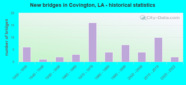
- New bridges - historical statistics
- 61930-1939
- 11940-1949
- 21950-1959
- 31960-1969
- 161970-1979
- 41980-1989
- 71990-1999
- 42000-2009
- 102010-2019
- 22020-2022
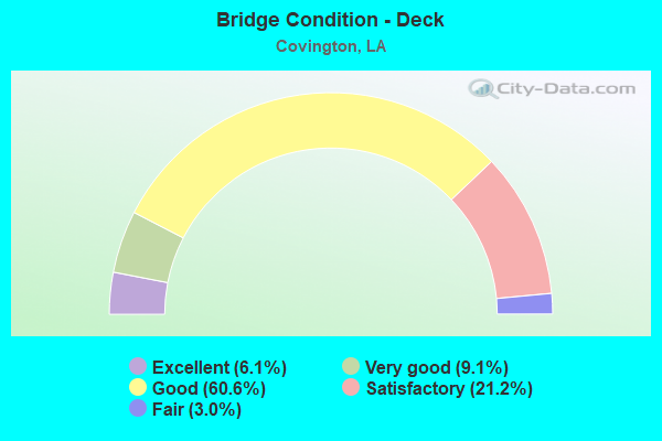
- Bridge Condition - Deck
- 6.1%Excellent
- 9.1%Very good
- 60.6%Good
- 21.2%Satisfactory
- 3.0%Fair
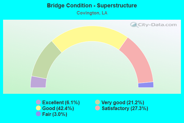
- Bridge Condition - Superstructure
- 6.1%Excellent
- 21.2%Very good
- 42.4%Good
- 27.3%Satisfactory
- 3.0%Fair
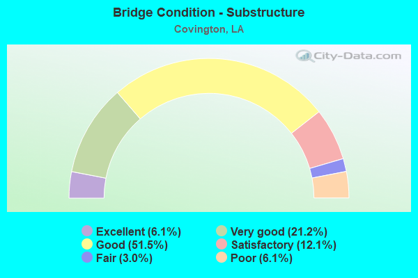
- Bridge Condition - Substructure
- 6.1%Excellent
- 21.2%Very good
- 51.5%Good
- 12.1%Satisfactory
- 3.0%Fair
- 6.1%Poor
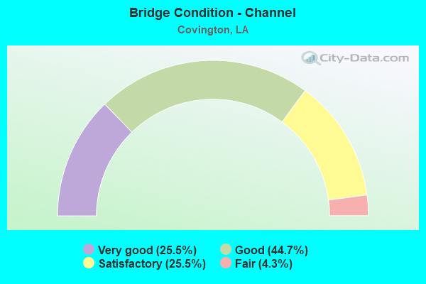
- Bridge Condition - Channel
- 25.5%Very good
- 44.7%Good
- 25.5%Satisfactory
- 4.3%Fair
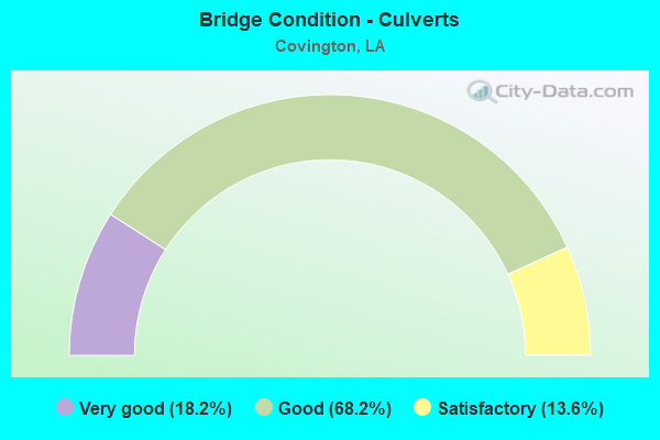
- Bridge Condition - Culverts
- 18.2%Very good
- 68.2%Good
- 13.6%Satisfactory
Find on map >> Show street view
Structure Number: 625204540410066, Location: 2.6 M W OF LA 59 (Lat: 30.430431, Lng: -90.084000), Route carried "on" structure: Ramp Interstate 12, Year Built: 1976, Status: Open, Structure Length: 11.22m (36.81ft), Average Daily Traffic: 6,730 (year 2016), Truck Traffic: 26%, Average Future Daily Traffic: 4,978 (year 2036), Design Load: HS 20, Features Intersected: US 190
Minimum Vertical Clearance: 30+ m (98+ ft), Kilometerpoint: 0.620, Lanes on structure: 1, Lanes under structure: 4, Owner: State Highway Agency, Approaching Roadway Width: 7.6m (24.9ft), Skew: 3 degrees, Material/Design: Steel, Design/Construction: Girder and Floorbeam System, Number Of Spans In Main Unit: 5, Length of Maximum Span: 29.0m (95.1ft), Curb-To-Curb Width: 7.6m (24.9ft), Out-to-Out Width: 8.6m (28.2ft)
Condition: Deck: Good, Superstructure: Satisfactory, Substructure: Good, Operating Rating: 52.6 metric tons, Method Used To Determine Operating Rating: Load Factor (LF), Inventory Rating: 31.7 metric tons, Method Used To Determine Inventory Rating: Load Factor (LF), Structural Evaluation: Equal to present minimum criteria, Deck Geometry: Better than present minimum criteria, Underclear: Better than present minimum criteria, Approach Roadway Alignment: Equal to present desirable criteria, Designated Inspection Frequency: Every 24 months, Critical Feature Inspection Frequency: Every 24 months, Inspection Date: August 2021, Critical Feature Inspection Date: August 2021, Deck Structure Type: Concrete Cast-file-Place
Find on map >> Show street view
Structure Number: 625204540410067, Location: 2.6 M W OF LA 59 (Lat: 30.427439, Lng: -90.085600), Route carried "on" structure: Ramp Interstate 12, Year Built: 1976, Status: Open, Structure Length: 12.65m (41.50ft), Average Daily Traffic: 6,730 (year 2016), Truck Traffic: 26%, Average Future Daily Traffic: 4,978 (year 2036), Design Load: HS 20, Features Intersected: US 190
Minimum Vertical Clearance: 30+ m (98+ ft), Kilometerpoint: 0.319, Lanes on structure: 1, Lanes under structure: 5, Owner: State Highway Agency, Approaching Roadway Width: 7.6m (24.9ft), Skew: 1 degrees, Material/Design: Steel, Design/Construction: Girder and Floorbeam System, Number Of Spans In Main Unit: 4, Length of Maximum Span: 37.2m (122.0ft), Curb-To-Curb Width: 7.6m (24.9ft), Out-to-Out Width: 8.6m (28.2ft)
Condition: Deck: Good, Superstructure: Good, Substructure: Good, Operating Rating: 54.4 metric tons, Method Used To Determine Operating Rating: Load Factor (LF), Inventory Rating: 32.7 metric tons, Method Used To Determine Inventory Rating: Load Factor (LF), Structural Evaluation: Better than present minimum criteria, Deck Geometry: Better than present minimum criteria, Underclear: Equal to present desirable criteria, Approach Roadway Alignment: Better than present minimum criteria, Designated Inspection Frequency: Every 24 months, Critical Feature Inspection Frequency: Every 24 months, Inspection Date: August 2021, Critical Feature Inspection Date: August 2021, Deck Structure Type: Concrete Cast-file-Place
Find on map >> Show street view
Structure Number: 625208520203191, Location: LA1085 (Lat: 30.464119, Lng: -90.201300), Route carried "on" structure: State highway 1085, Year Built: 1975, Status: Open, Structure Length: 11.22m (36.81ft), Average Daily Traffic: 4,700 (year 2016), Truck Traffic: 9%, Average Future Daily Traffic: 3,420 (year 2036), Design Load: HS 20, Features Intersected: LA 1085 OVER I-12
Minimum Vertical Clearance: 30+ m (98+ ft), Kilometerpoint: 5.195, Lanes on structure: 2, Lanes under structure: 4, Owner: State Highway Agency, Approaching Roadway Width: 11.0m (36.1ft), Skew: 3 degrees, Material/Design: Steel continuous, Design/Construction: Girder and Floorbeam System, Number Of Spans In Main Unit: 4, Length of Maximum Span: 34.4m (112.9ft), Curb-To-Curb Width: 7.9m (25.9ft), Out-to-Out Width: 9.1m (29.9ft)
Condition: Deck: Good, Superstructure: Good, Substructure: Very good, Operating Rating: 39.9 metric tons, Method Used To Determine Operating Rating: Load Factor (LF), Inventory Rating: 23.6 metric tons, Method Used To Determine Inventory Rating: Load Factor (LF), Structural Evaluation: Equal to present minimum criteria, Deck Geometry: High priority of corrective action, Underclear: Equal to present minimum criteria, Approach Roadway Alignment: Equal to present desirable criteria, Length Of Structure Improvement: 12.13m (39.80ft), Designated Inspection Frequency: Every 24 months, Inspection Date: August 2021, Bridge Improvement Cost: $1,034,000, Total Project Cost: $1,551,000 ( Estimate for 2016), Deck Structure Type: Concrete Cast-file-Place
Find on map >> Show street view
Structure Number: 625208520302851, Location: LA1077 (Lat: 30.457169, Lng: -90.177400), Route carried "on" structure: State highway 1077, Year Built: 1975, Status: Open, Structure Length: 11.70m (38.39ft), Average Daily Traffic: 14,100 (year 2016), Truck Traffic: 8%, Average Future Daily Traffic: 10,412 (year 2036), Design Load: HS 20, Features Intersected: LA 1077 OVER I-12
Minimum Vertical Clearance: 30+ m (98+ ft), Kilometerpoint: 4.593, Lanes on structure: 2, Lanes under structure: 4, Owner: State Highway Agency, Approaching Roadway Width: 12.2m (40.0ft), Skew: 4 degrees, Material/Design: Steel, Design/Construction: Stringer/Multi-beam, Number Of Spans In Main Unit: 4, Length of Maximum Span: 36.0m (118.1ft), Curb-To-Curb Width: 12.2m (40.0ft), Out-to-Out Width: 13.2m (43.3ft)
Condition: Deck: Good, Superstructure: Good, Substructure: Good, Operating Rating: 56.2 metric tons, Method Used To Determine Operating Rating: Load Factor (LF), Inventory Rating: 33.6 metric tons, Method Used To Determine Inventory Rating: Load Factor (LF), Structural Evaluation: Better than present minimum criteria, Deck Geometry: Somewhat better than minimum adequacy, Underclear: Somewhat better than minimum adequacy, Approach Roadway Alignment: Equal to present desirable criteria, Designated Inspection Frequency: Every 24 months, Inspection Date: August 2021, Deck Structure Type: Concrete Cast-file-Place
Find on map >> Show street view
Structure Number: 625230123900731, Location: CAUSEWAY SOUTHBOUND (Lat: 30.363989, Lng: -90.094050), Route carried "on" structure: County highway , Year Built: 1956, Status: Open, Structure Length: 3877.06m (12720.01ft), Average Daily Traffic: 18,830 (year 1987), Average Future Daily Traffic: 14,310 (year 2036), Design Load: HS 20, Features Intersected: LAKE PONTCHARTRAIN, Facility Carried by Structure: CAUSEWAY SB
Minimum Vertical Clearance: 30+ m (98+ ft), Kilometerpoint: 0.000, Lanes on structure: 2, Base Highway Network: Yes, Toll: Toll bridge, Owner: Local Toll Authority, Approaching Roadway Width: 9.8m (32.2ft), Skew: 10 degrees, Navigation Control: Yes ( Vertical Clearance: 304.5m (999.0ft), Horizontal Clearance: 38.1m (125.0ft)), Material/Design: Steel, Design/Construction: Movable - Bascule, Number Of Spans In Main Unit: 1, Number Of Approach Spans: 1500, Length of Maximum Span: 54.9m (180.1ft), Curb-To-Curb Width: 8.5m (27.9ft), Out-to-Out Width: 9.6m (31.5ft)
Condition: Deck: Good, Superstructure: Satisfactory, Substructure: Good, Channel: Very good, Operating Rating: 35.0 metric tons, Method Used To Determine Operating Rating: Load and Resistance Factor Rating (LRFR) rating reported by rating factor(RF) method using HL-93 loadings, Inventory Rating: 29.5 metric tons, Method Used To Determine Inventory Rating: Load and Resistance Factor Rating (LRFR) rating reported by rating factor(RF) method using HL-93 loadings, Structural Evaluation: Equal to present minimum criteria, Deck Geometry: High priority of corrective action, Waterway Adequacy: Equal to present desirable criteria, Approach Roadway Alignment: Equal to present desirable criteria, Length Of Structure Improvement: 3835.21m (12582.71ft), Designated Inspection Frequency: Every 24 months, Critical Feature Inspection Frequency: Every 24 months, Underwater Inspection Frequency: Every 60 months, Inspection Date: November 2019, Critical Feature Inspection Date: November 2019, Underwater Inspection Date: November 2018, Bridge Improvement Cost: $229,005,000, Total Project Cost: $343,507,000 ( Estimate for 2016), Deck Structure Type: Open Grating, Wearing Surface/Protective System: Wearing Surface: Monolithic Concrete
Find on map >> Show street view
Structure Number: 625230265900561, Location: .9 MI W US 190-VERSAILLES (Lat: 30.435911, Lng: -90.096769), Route carried "on" structure: County highway , Year Built: 1996, Status: Open, Structure Length: 0.98m (3.22ft), Average Daily Traffic: 300 (year 2020), Average Future Daily Traffic: 330 (year 2040), Design Load: HS 20, Features Intersected: PIPE AT CREEK, Facility Carried by Structure: AVE LOUIS QUATROZE
Minimum Vertical Clearance: 30+ m (98+ ft), Kilometerpoint: 0.000, Lanes on structure: 2, Base Highway Network: Yes, Owner: County Highway Agency, Approaching Roadway Width: 6.1m (20.0ft), Skew: 5 degrees, Material/Design: Steel, Design/Construction: Culvert, Length of Maximum Span: 3.0m (9.8ft)
Condition: Channel: Satisfactory, Culverts: Good, Operating Rating: 51.5 metric tons, Method Used To Determine Operating Rating: Load and Resistance Factor Rating (LRFR) rating reported by rating factor(RF) method using HL-93 loadings, Inventory Rating: 39.9 metric tons, Method Used To Determine Inventory Rating: Load and Resistance Factor Rating (LRFR) rating reported by rating factor(RF) method using HL-93 loadings, Structural Evaluation: Better than present minimum criteria, Waterway Adequacy: Better than present minimum criteria, Approach Roadway Alignment: Equal to present minimum criteria, Designated Inspection Frequency: Every 24 months, Inspection Date: January 2021, Deck Structure Type: Other
Find on map >> Show street view
Structure Number: 625230283900881, Location: 0.45 MILES NORTH OF LA.10 (Lat: 30.473689, Lng: -90.148161), Route carried "on" structure: County highway , Year Built: 1973, Status: Posted for load, Structure Length: 2.32m (7.61ft), Average Daily Traffic: 458 (year 2017), Average Future Daily Traffic: 503 (year 2037), Design Load: HS 20, Features Intersected: TCHEFUNETE RIVER, Facility Carried by Structure: Rousseau Rd
Minimum Vertical Clearance: 30+ m (98+ ft), Kilometerpoint: 0.000, Lanes on structure: 2, Owner: County Highway Agency, Approaching Roadway Width: 8.8m (28.9ft), Material/Design: Concrete, Design/Construction: Slab, Number Of Spans In Main Unit: 4, Length of Maximum Span: 5.8m (19.0ft), Curb-To-Curb Width: 8.5m (27.9ft), Out-to-Out Width: 9.4m (30.8ft)
Condition: Deck: Good, Superstructure: Good, Substructure: Fair, Channel: Good, Operating Rating: 25.9 metric tons, Method Used To Determine Operating Rating: Load and Resistance Factor Rating (LRFR) rating reported by rating factor(RF) method using HL-93 loadings, Inventory Rating: 19.8 metric tons, Method Used To Determine Inventory Rating: Load and Resistance Factor Rating (LRFR) rating reported by rating factor(RF) method using HL-93 loadings, Structural Evaluation: Somewhat better than minimum adequacy, Deck Geometry: Somewhat better than minimum adequacy, Waterway Adequacy: Better than present minimum criteria, Approach Roadway Alignment: Better than present minimum criteria, Bridge Posting: Required (Relationship of Operating Rating to Maximum Legal Load: 10.0 - 19.9% below), Designated Inspection Frequency: Every 24 months, Inspection Date: Febuary 2021, Deck Structure Type: Steel plate
Find on map >> Show street view
Structure Number: 625230285901241, Location: LA 1077 1.2 MI N JCT 1085 (Lat: 30.481939, Lng: -90.205150), Route carried "on" structure: County highway , Year Built: 1995, Status: Open, Structure Length: 0.85m (2.79ft), Average Daily Traffic: 50 (year 2016), Average Future Daily Traffic: 38 (year 2036), Design Load: HS 20, Features Intersected: EAST BEDICO CREEK BRIDGE, Facility Carried by Structure: Joiner Rd
Minimum Vertical Clearance: 30+ m (98+ ft), Kilometerpoint: 0.000, Lanes on structure: 2, Base Highway Network: Yes, Owner: County Highway Agency, Approaching Roadway Width: 6.1m (20.0ft), Material/Design: Concrete, Design/Construction: Culvert, Length of Maximum Span: 2.7m (8.9ft)
Condition: Channel: Satisfactory, Culverts: Good, Operating Rating: 42.1 metric tons, Method Used To Determine Operating Rating: Load and Resistance Factor Rating (LRFR) rating reported by rating factor(RF) method using HL-93 loadings, Inventory Rating: 32.4 metric tons, Method Used To Determine Inventory Rating: Load and Resistance Factor Rating (LRFR) rating reported by rating factor(RF) method using HL-93 loadings, Structural Evaluation: Better than present minimum criteria, Waterway Adequacy: Better than present minimum criteria, Approach Roadway Alignment: Better than present minimum criteria, Designated Inspection Frequency: Every 24 months, Inspection Date: January 2021
Find on map >> Show street view
Structure Number: 625230288900661, Location: 0.4 MILE EAST OF JOHNSON (Lat: 30.478039, Lng: -90.109861), Route carried "on" structure: County highway , Year Built: 1990, Status: Open, Structure Length: 1.07m (3.51ft), Average Daily Traffic: 300 (year 1989), Average Future Daily Traffic: 228 (year 2036), Design Load: HS 20, Features Intersected: MILE BRANCH, Facility Carried by Structure: W. 19th Ave
Minimum Vertical Clearance: 30+ m (98+ ft), Kilometerpoint: 0.000, Lanes on structure: 2, Owner: City or Municipal Highway Agency, Approaching Roadway Width: 7.6m (24.9ft), Material/Design: Steel, Design/Construction: Culvert, Number Of Spans In Main Unit: 3, Length of Maximum Span: 3.0m (9.8ft), Curb-To-Curb Width: 7.6m (24.9ft), Out-to-Out Width: 16.8m (55.1ft)
Condition: Channel: Satisfactory, Culverts: Good, Operating Rating: 31.4 metric tons, Method Used To Determine Operating Rating: Load and Resistance Factor Rating (LRFR) rating reported by rating factor(RF) method using HL-93 loadings, Inventory Rating: 24.3 metric tons, Method Used To Determine Inventory Rating: Load and Resistance Factor Rating (LRFR) rating reported by rating factor(RF) method using HL-93 loadings, Structural Evaluation: Equal to present minimum criteria, Deck Geometry: Somewhat better than minimum adequacy, Waterway Adequacy: Better than present minimum criteria, Approach Roadway Alignment: Equal to present desirable criteria, Designated Inspection Frequency: Every 24 months, Inspection Date: January 2021, Deck Structure Type: Other
Find on map >> Show street view
Structure Number: 625230295900451, Location: 0.1 MILES WEST OF LA 21 (Lat: 30.491011, Lng: -90.074561), Route carried "on" structure: County highway , Year Built: 2006, Status: Open, Structure Length: 0.67m (2.20ft), Average Daily Traffic: 600 (year 2016), Average Future Daily Traffic: 456 (year 2036), Design Load: HS 20, Features Intersected: CREEK, Facility Carried by Structure: Holly Dr
Minimum Vertical Clearance: 30+ m (98+ ft), Kilometerpoint: 0.000, Lanes on structure: 2, Base Highway Network: Yes, Owner: County Highway Agency, Approaching Roadway Width: 6.7m (22.0ft), Skew: 7 degrees, Material/Design: Concrete, Design/Construction: Culvert, Number Of Spans In Main Unit: 2, Length of Maximum Span: 3.0m (9.8ft), Curb-To-Curb Width: 11.6m (38.1ft), Out-to-Out Width: 12.2m (40.0ft)
Condition: Channel: Satisfactory, Culverts: Satisfactory, Operating Rating: 42.1 metric tons, Method Used To Determine Operating Rating: Load and Resistance Factor Rating (LRFR) rating reported by rating factor(RF) method using HL-93 loadings, Inventory Rating: 32.4 metric tons, Method Used To Determine Inventory Rating: Load and Resistance Factor Rating (LRFR) rating reported by rating factor(RF) method using HL-93 loadings, Structural Evaluation: Equal to present minimum criteria, Deck Geometry: Better than present minimum criteria, Waterway Adequacy: Equal to present minimum criteria, Approach Roadway Alignment: Equal to present minimum criteria, Designated Inspection Frequency: Every 24 months, Inspection Date: November 2020, Deck Structure Type: Other
Find on map >> Show street view
Structure Number: 625230297900411, Location: 1MI.N.OF JCT LA 21 & LA36 (Lat: 30.496881, Lng: -90.072261), Route carried "on" structure: County highway , Year Built: 1996, Status: Posted for load, Structure Length: 0.98m (3.22ft), Average Daily Traffic: 100 (year 2016), Average Future Daily Traffic: 76 (year 2036), Design Load: H 10, Features Intersected: BRIDGE OVER UNNAMED CREE, Facility Carried by Structure: Magnolia Gardens
Minimum Vertical Clearance: 30+ m (98+ ft), Kilometerpoint: 0.000, Lanes on structure: 1, Base Highway Network: Yes, Owner: County Highway Agency, Approaching Roadway Width: 5.5m (18.0ft), Material/Design: Wood or Timber, Design/Construction: Stringer/Multi-beam, Number Of Spans In Main Unit: 3, Length of Maximum Span: 3.4m (11.2ft), Curb-To-Curb Width: 4.6m (15.1ft), Out-to-Out Width: 5.1m (16.7ft)
Condition: Deck: Satisfactory, Superstructure: Satisfactory, Substructure: Satisfactory, Channel: Good, Operating Rating: 11.3 metric tons, Method Used To Determine Operating Rating: Allowable Stress (AS), Inventory Rating: 7.9 metric tons, Method Used To Determine Inventory Rating: Allowable Stress (AS), Structural Evaluation: High priority of replacement, Deck Geometry: Better than present minimum criteria, Waterway Adequacy: Equal to present minimum criteria, Approach Roadway Alignment: Equal to present minimum criteria, Bridge Posting: Required (Relationship of Operating Rating to Maximum Legal Load: 30.0 - 39.9% below), Length Of Structure Improvement: 1.62m (5.31ft), Designated Inspection Frequency: Every 24 months, Other Special Inspection Frequency: Every 12 months, Inspection Date: January 2021, Other Special Inspection Date: January 2022, Bridge Improvement Cost: $96,000, Total Project Cost: $144,000 ( Estimate for 2016), Deck Structure Type: Wood or Timber
Find on map >> Show street view
Structure Number: 625230311900611, Location: 2 MI NE OF LA 437 (Lat: 30.519619, Lng: -90.102211), Route carried "on" structure: County highway , Year Built: 1980, Status: Posted for load, Structure Length: 4.66m (15.29ft), Average Daily Traffic: 839 (year 2017), Average Future Daily Traffic: 922 (year 2037), Design Load: HS 20, Features Intersected: BR. OV BOGUE FALAYA RIVE, Facility Carried by Structure: Hosmer Mill Rd
Minimum Vertical Clearance: 30+ m (98+ ft), Kilometerpoint: 0.000, Lanes on structure: 2, Base Highway Network: Yes, Owner: County Highway Agency, Approaching Roadway Width: 7.0m (23.0ft), Material/Design: Concrete, Design/Construction: Slab, Number Of Spans In Main Unit: 8, Length of Maximum Span: 5.8m (19.0ft), Curb-To-Curb Width: 6.1m (20.0ft), Out-to-Out Width: 7.1m (23.3ft)
Condition: Deck: Fair, Superstructure: Fair, Substructure: Poor, Channel: Fair, Operating Rating: 14.6 metric tons, Method Used To Determine Operating Rating: Load and Resistance Factor Rating (LRFR) rating reported by rating factor(RF) method using HL-93 loadings, Inventory Rating: 11.3 metric tons, Method Used To Determine Inventory Rating: Load and Resistance Factor Rating (LRFR) rating reported by rating factor(RF) method using HL-93 loadings, Structural Evaluation: High priority of replacement, Deck Geometry: High priority of corrective action, Waterway Adequacy: Equal to present minimum criteria, Approach Roadway Alignment: Better than present minimum criteria, Bridge Posting: Required (Relationship of Operating Rating to Maximum Legal Load: 30.0 - 39.9% below), Length Of Structure Improvement: 5.58m (18.31ft), Designated Inspection Frequency: Every 24 months, Other Special Inspection Frequency: Every 12 months, Inspection Date: March 2021, Other Special Inspection Date: September 2021, Bridge Improvement Cost: $333,000, Total Project Cost: $499,000 ( Estimate for 2016), Deck Structure Type: Concrete Cast-file-Place, Wearing Surface/Protective System: Wearing Surface: Bituminous
Find on map >> Show street view
Structure Number: 625230318900501, Location: 3.35M S.OF LA 437 &LA1081 (Lat: 30.531081, Lng: -90.083489), Route carried "on" structure: County highway , Year Built: 1996, Status: Open, Structure Length: 1.83m (6.00ft), Average Daily Traffic: 872 (year 2017), Average Future Daily Traffic: 959 (year 2037), Design Load: HS 20, Features Intersected: METRCH PIPE @ TICE BRANC, Facility Carried by Structure: Fitzmorris Rd
Minimum Vertical Clearance: 30+ m (98+ ft), Kilometerpoint: 0.000, Lanes on structure: 2, Base Highway Network: Yes, Owner: County Highway Agency, Approaching Roadway Width: 6.7m (22.0ft), Material/Design: Steel, Design/Construction: Culvert, Number Of Spans In Main Unit: 5, Length of Maximum Span: 2.4m (7.9ft), Curb-To-Curb Width: 7.0m (23.0ft), Out-to-Out Width: 7.3m (24.0ft)
Condition: Channel: Satisfactory, Culverts: Satisfactory, Operating Rating: 74.8 metric tons, Method Used To Determine Operating Rating: Load and Resistance Factor Rating (LRFR) rating reported by rating factor(RF) method using HL-93 loadings, Inventory Rating: 57.7 metric tons, Method Used To Determine Inventory Rating: Load and Resistance Factor Rating (LRFR) rating reported by rating factor(RF) method using HL-93 loadings, Structural Evaluation: Equal to present minimum criteria, Deck Geometry: Meets minimum limits, Waterway Adequacy: Better than present minimum criteria, Approach Roadway Alignment: Equal to present minimum criteria, Designated Inspection Frequency: Every 24 months, Inspection Date: December 2020
Find on map >> Show street view
Structure Number: 625230333900751, Location: 1.40 EAST OF LA 25 (Lat: 30.555281, Lng: -90.127561), Route carried "on" structure: County highway , Year Built: 1987, Status: Posted for load, Structure Length: 1.74m (5.71ft), Average Daily Traffic: 300 (year 2016), Average Future Daily Traffic: 228 (year 2036), Design Load: HS 20, Features Intersected: BR. OVER TIGER BRANCH, Facility Carried by Structure: Tiger branch
Minimum Vertical Clearance: 30+ m (98+ ft), Kilometerpoint: 0.000, Lanes on structure: 2, Owner: County Highway Agency, Approaching Roadway Width: 6.7m (22.0ft), Material/Design: Concrete, Design/Construction: Slab, Number Of Spans In Main Unit: 3, Length of Maximum Span: 5.8m (19.0ft), Curb-To-Curb Width: 7.3m (24.0ft), Out-to-Out Width: 8.4m (27.6ft)
Condition: Deck: Satisfactory, Superstructure: Satisfactory, Substructure: Poor, Channel: Satisfactory, Operating Rating: 24.6 metric tons, Method Used To Determine Operating Rating: Load and Resistance Factor Rating (LRFR) rating reported by rating factor(RF) method using HL-93 loadings, Inventory Rating: 16.8 metric tons, Method Used To Determine Inventory Rating: Load and Resistance Factor Rating (LRFR) rating reported by rating factor(RF) method using HL-93 loadings, Structural Evaluation: Meets minimum limits, Deck Geometry: Somewhat better than minimum adequacy, Waterway Adequacy: Better than present minimum criteria, Approach Roadway Alignment: Better than present minimum criteria, Bridge Posting: Required (Relationship of Operating Rating to Maximum Legal Load: 0.1 - 9.9% below), Designated Inspection Frequency: Every 24 months, Other Special Inspection Frequency: Every 12 months, Inspection Date: January 2021, Other Special Inspection Date: January 2020, Deck Structure Type: Concrete Precast Panels
Find on map >> Show street view
Structure Number: 625200593001701, Location: US 190 BR @ US 190 (Lat: 30.476811, Lng: -90.087369), Route carried "under" structure: Business US 190, Structure Length: 0. m, Average Daily Traffic: 11,650 (year 2014), Features Intersected: US 190 BR UNDER US 190
Minimum Vertical Clearance: 5.88m (19.29ft), Kilometerpoint: 15.986, Lanes on structure: 2, Lanes under structure: 4, Length of Maximum Span: 0.0m
Find on map >> Show street view
Structure Number: 625204540406601, Location: 0.9 MI S of LA 1085 (Lat: 30.446631, Lng: -90.140431), Route carried "under" structure: State highway 21, Structure Length: 0. m, Average Daily Traffic: 22,700 (year 2016), Features Intersected: LA 21 NB under I-12 EB
Minimum Vertical Clearance: 4.97m (16.31ft), Kilometerpoint: 5.557, Lanes on structure: 4, Length of Maximum Span: 0.0m
Find on map >> Show street view
Structure Number: 625204540406601, Location: 0.9 MI S of LA 1085 (Lat: 30.446789, Lng: -90.140550), Route carried "under" structure: State highway 21, Structure Length: 0. m, Average Daily Traffic: 22,700 (year 2016), Features Intersected: LA 21 SB under I-12 EB
Minimum Vertical Clearance: 4.97m (16.31ft), Kilometerpoint: 5.058, Lanes on structure: 4, Length of Maximum Span: 0.0m
Find on map >> Show street view
Structure Number: 625204540406602, Location: 0.9 MI S of LA 1085 (Lat: 30.446850, Lng: -90.140261), Route carried "under" structure: State highway 21, Structure Length: 0. m, Average Daily Traffic: 22,700 (year 2016), Features Intersected: LA 21 NB under I-12 WB
Minimum Vertical Clearance: 4.91m (16.11ft), Kilometerpoint: 5.586, Lanes on structure: 4, Length of Maximum Span: 0.0m
Find on map >> Show street view
Structure Number: 625204540406602, Location: 0.9 MI S of LA 1085 (Lat: 30.447000, Lng: -90.140381), Route carried "under" structure: State highway 21, Structure Length: 0. m, Average Daily Traffic: 22,700 (year 2016), Features Intersected: LA 21 SB under I-12 WB
Minimum Vertical Clearance: 4.94m (16.21ft), Kilometerpoint: 5.029, Lanes on structure: 4, Length of Maximum Span: 0.0m
Find on map >> Show street view
Structure Number: 625204540410061, Location: 2.4 MI N of LA 22 (Lat: 30.429089, Lng: -90.084889), Route carried "under" structure: US 190, Structure Length: 0. m, Average Daily Traffic: 50,400 (year 2016), Features Intersected: US 190 SB undr I-12 EB
Minimum Vertical Clearance: 4.91m (16.11ft), Kilometerpoint: 5.020, Lanes on structure: 3, Length of Maximum Span: 0.0m
Find on map >> Show street view
Structure Number: 625204540410061, Location: 2.4 MI N of LA 22 (Lat: 30.428569, Lng: -90.083350), Route carried "under" structure: Ramp Interstate 12, Structure Length: 0. m, Average Daily Traffic: 6,550 (year 2016), Features Intersected: I-12 EB off-ramp to US 1
Minimum Vertical Clearance: 4.94m (16.21ft), Kilometerpoint: 0.591, Lanes on structure: 1, Length of Maximum Span: 0.0m
Find on map >> Show street view
Structure Number: 625204540410061, Location: 2.4 MI N of LA 22 (Lat: 30.428689, Lng: -90.083869), Route carried "under" structure: Ramp Interstate 12, Structure Length: 0. m, Average Daily Traffic: 6,550 (year 2016), Features Intersected: I-12 WB on-ramp from US
Minimum Vertical Clearance: 5.91m (19.39ft), Kilometerpoint: 0.418, Lanes on structure: 1, Length of Maximum Span: 0.0m
Find on map >> Show street view
Structure Number: 625204540410061, Location: 2.4 MI N of LA 22 (Lat: 30.428869, Lng: -90.084619), Route carried "under" structure: US 190, Structure Length: 0. m, Average Daily Traffic: 50,400 (year 2016), Features Intersected: US 190 NB under I-12 EB
Minimum Vertical Clearance: 5.36m (17.59ft), Kilometerpoint: 4.748, Lanes on structure: 2, Length of Maximum Span: 0.0m
Find on map >> Show street view
Structure Number: 625204540410062, Location: 2.4 MI N of LA 22 (Lat: 30.429389, Lng: -90.084839), Route carried "under" structure: US 190, Structure Length: 0. m, Average Daily Traffic: 50,400 (year 2016), Features Intersected: US 190 SB under I-12 WB
Minimum Vertical Clearance: 4.97m (16.31ft), Kilometerpoint: 4.986, Lanes on structure: 3, Length of Maximum Span: 0.0m
Find on map >> Show street view
Structure Number: 625204540410062, Location: 2.4 MI N of LA 22 (Lat: 30.429161, Lng: -90.084569), Route carried "under" structure: US 190, Structure Length: 0. m, Average Daily Traffic: 50,400 (year 2016), Features Intersected: US 190 NB under 1-12 WB
Minimum Vertical Clearance: 5.30m (17.39ft), Kilometerpoint: 4.780, Lanes on structure: 2, Length of Maximum Span: 0.0m
Find on map >> Show street view
Structure Number: 625204540410062, Location: 2.4 MI N of LA 22 (Lat: 30.428961, Lng: -90.083761), Route carried "under" structure: Ramp Interstate 12, Structure Length: 0. m, Average Daily Traffic: 6,550 (year 2016), Features Intersected: I-12 WB On-Ramp from US
Minimum Vertical Clearance: 5.00m (16.40ft), Kilometerpoint: 0.449, Lanes on structure: 1, Length of Maximum Span: 0.0m
Find on map >> Show street view
Structure Number: 625204540410062, Location: 2.4 MI N of LA 22 (Lat: 30.428839, Lng: -90.083250), Route carried "under" structure: Ramp Interstate 12, Structure Length: 0. m, Average Daily Traffic: 6,550 (year 2016), Features Intersected: I-12 EB off-ramp to US 1
Minimum Vertical Clearance: 5.06m (16.60ft), Kilometerpoint: 0.621, Lanes on structure: 1, Length of Maximum Span: 0.0m
Find on map >> Show street view
Structure Number: 625204540410066, Location: 2.5 MI N of LA 22 (Lat: 30.430989, Lng: -90.084569), Route carried "under" structure: US 190, Structure Length: 0. m, Average Daily Traffic: 50,400 (year 2016), Features Intersected: US 190 SB under I-12 WB
Minimum Vertical Clearance: 5.09m (16.70ft), Kilometerpoint: 4.806, Lanes on structure: 2, Length of Maximum Span: 0.0m
Find on map >> Show street view
Structure Number: 625208520203191, Location: 1.4 MI W of LA 1077 (Lat: 30.464319, Lng: -90.201000), Route carried "under" structure: Interstate 12, Structure Length: 0. m, Average Daily Traffic: 52,500 (year 2016), Features Intersected: I-12 EB under LA 1085
Minimum Vertical Clearance: 5.03m (16.50ft), Kilometerpoint: 4.582, Lanes on structure: 2, Length of Maximum Span: 0.0m
Find on map >> Show street view
Structure Number: 625208520203191, Location: 1.4 MI W of LA 1077 (Lat: 30.464450, Lng: -90.200581), Route carried "under" structure: Interstate 12, Structure Length: 0. m, Average Daily Traffic: 52,500 (year 2016), Features Intersected: I-12 WB under LA 1085
Minimum Vertical Clearance: 4.97m (16.31ft), Kilometerpoint: 49.305, Lanes on structure: 2, Length of Maximum Span: 0.0m
Find on map >> Show street view
Structure Number: 625208520302851, Location: 1.4 MI E of LA 1085 (Lat: 30.457539, Lng: -90.177681), Route carried "under" structure: Interstate 12, Structure Length: 0. m, Average Daily Traffic: 57,000 (year 2015), Features Intersected: I-12 EB under LA 1077
Minimum Vertical Clearance: 4.94m (16.21ft), Kilometerpoint: 6.946, Lanes on structure: 2, Length of Maximum Span: 0.0m
Find on map >> Show street view
Structure Number: 625208520302851, Location: 1.4 MI E of LA 1085 (Lat: 30.457789, Lng: -90.177661), Route carried "under" structure: Interstate 12, Structure Length: 0. m, Average Daily Traffic: 57,000 (year 2015), Features Intersected: I-12 WB under LA 1077
Minimum Vertical Clearance: 4.91m (16.11ft), Kilometerpoint: 46.982, Lanes on structure: 2, Length of Maximum Span: 0.0m