Bridge Statistics for Crawfordsville, Indiana (IN)
Condition, Traffic, Stress, Structural Evaluation, Project Costs
- National Bridge Inventory (NBI) Statistics
- 97Number of bridges
- 1,070ft / 326mTotal length
- $4,154,000Total costs
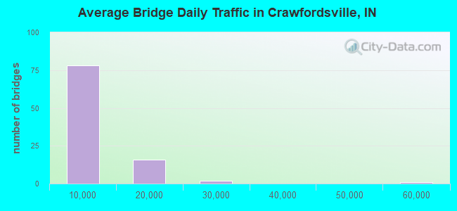
- 590,323Total average daily traffic
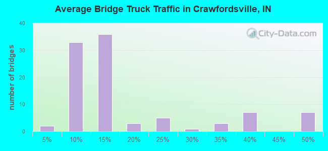
- 113,430Total average daily truck traffic
- National Bridge Inventory (NBI) Registered Bridges for Crawfordsville
- No street view available for this location
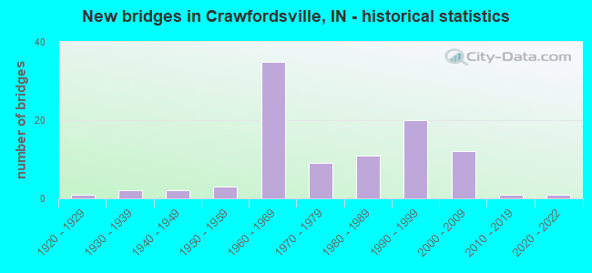
- New bridges - historical statistics
- 11920-1929
- 21930-1939
- 21940-1949
- 31950-1959
- 351960-1969
- 91970-1979
- 111980-1989
- 201990-1999
- 122000-2009
- 12010-2019
- 12020-2022
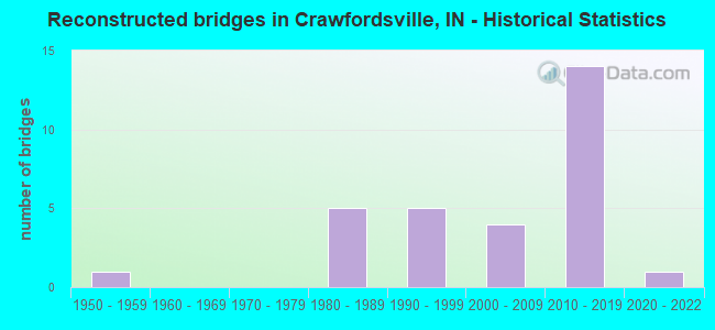
- Reconstructed bridges - Historical Statistics
- 11950-1959
- 01960-1969
- 01970-1979
- 51980-1989
- 51990-1999
- 42000-2009
- 142010-2019
- 12020-2022
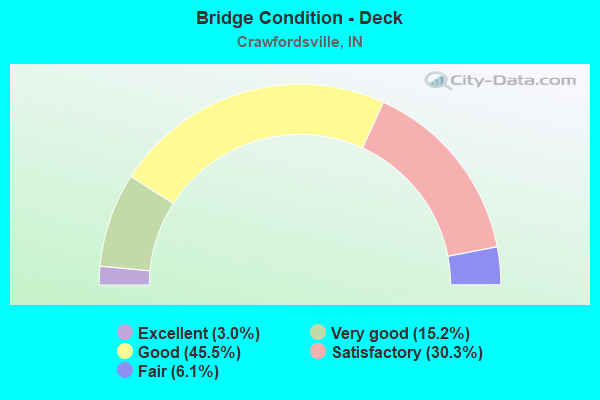
- Bridge Condition - Deck
- 3.0%Excellent
- 15.2%Very good
- 45.5%Good
- 30.3%Satisfactory
- 6.1%Fair
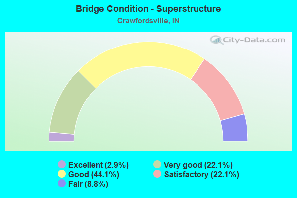
- Bridge Condition - Superstructure
- 2.9%Excellent
- 22.1%Very good
- 44.1%Good
- 22.1%Satisfactory
- 8.8%Fair
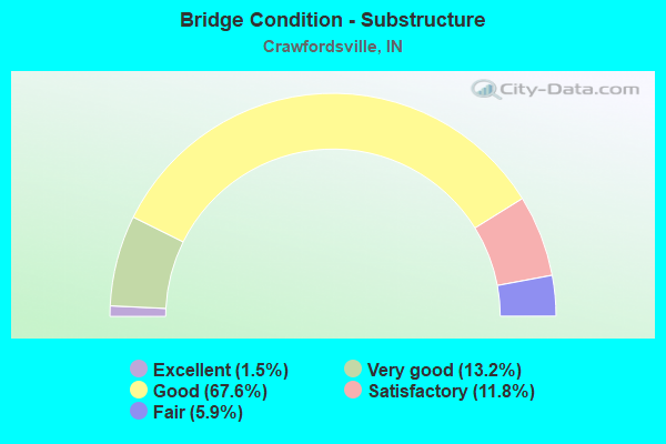
- Bridge Condition - Substructure
- 1.5%Excellent
- 13.2%Very good
- 67.6%Good
- 11.8%Satisfactory
- 5.9%Fair
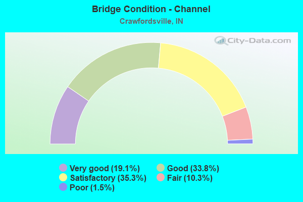
- Bridge Condition - Channel
- 19.1%Very good
- 33.8%Good
- 35.3%Satisfactory
- 10.3%Fair
- 1.5%Poor
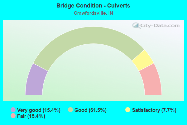
- Bridge Condition - Culverts
- 15.4%Very good
- 61.5%Good
- 7.7%Satisfactory
- 15.4%Fair
Find on map >> Show street view
Structure Number: 5400276, Location: 00.60 S of CR 400 N (Lat: 40.087731, Lng: -86.919689), Route carried "on" structure: County highway 51, Year Built: 2021, Status: Open, Structure Length: 2.29m (7.51ft), Average Daily Traffic: 140 (year 2021), Truck Traffic: 10%, Average Future Daily Traffic: 200 (year 2040), Design Load: HL 93, Features Intersected: BLACK CREEK, Facility Carried by Structure: CR 100W
Minimum Vertical Clearance: 30+ m (98+ ft), Kilometerpoint: 0.000, Lanes on structure: 2, Owner: County Highway Agency, Approaching Roadway Width: 7.3m (24.0ft), Skew: 3 degrees, Material/Design: Prestressed concrete, Design/Construction: Stringer/Multi-beam, Number Of Spans In Main Unit: 1, Length of Maximum Span: 22.3m (73.2ft), Curb-To-Curb Width: 7.3m (24.0ft), Out-to-Out Width: 7.4m (24.3ft)
Condition: Deck: Excellent, Superstructure: Excellent, Substructure: Excellent, Channel: Very good, Operating Rating: 53.8 metric tons, Method Used To Determine Operating Rating: Load and Resistance Factor Rating (LRFR) rating reported by rating factor(RF) method using HL-93 loadings, Inventory Rating: 37.3 metric tons, Method Used To Determine Inventory Rating: Load and Resistance Factor Rating (LRFR) rating reported by rating factor(RF) method using HL-93 loadings, Structural Evaluation: Superior to present desirable criteria, Deck Geometry: Somewhat better than minimum adequacy, Waterway Adequacy: Superior to present desirable criteria, Approach Roadway Alignment: Equal to present minimum criteria, Designated Inspection Frequency: Every 24 months, Inspection Date: November 2021, Deck Structure Type: Concrete Cast-file-Place, Wearing Surface/Protective System: Wearing Surface: Monolithic Concrete
Find on map >> Show street view
Structure Number: 105, Location: 03.38 E SR 47 (Lat: 40.047019, Lng: -86.812042), Route carried "under" structure: Interstate 74, Year Built: 1964, Structure Length: 0. m, Average Daily Traffic: 7,279 (year 2014), Truck Traffic: 45%, Features Intersected: I-74 WB, Facility Carried by Structure: SR 32
Minimum Vertical Clearance: 4.90m (16.08ft), Kilometerpoint: 63.199, Lanes on structure: 2, Lanes under structure: 2, Material/Design: Steel continuous, Design/Construction: Stringer/Multi-beam, Length of Maximum Span: 25.2m (82.7ft)
Find on map >> Show street view
Structure Number: 105, Location: 03.38 E SR 47 (Lat: 40.047019, Lng: -86.812042), Route carried "under" structure: Interstate 74, Year Built: 1964, Structure Length: 0. m, Average Daily Traffic: 7,279 (year 2014), Truck Traffic: 45%, Features Intersected: I-74 EB, Facility Carried by Structure: SR 32
Minimum Vertical Clearance: 4.95m (16.24ft), Kilometerpoint: 63.199, Lanes on structure: 2, Lanes under structure: 2, Material/Design: Steel continuous, Design/Construction: Stringer/Multi-beam, Length of Maximum Span: 25.2m (82.7ft)
Find on map >> Show street view
Structure Number: 4406, Location: 00.90 W US 231 (Lat: 40.083719, Lng: -86.920272), Route carried "under" structure: Interstate 74, Year Built: 1964, Structure Length: 0. m, Average Daily Traffic: 20,469 (year 2004), Truck Traffic: 10%, Features Intersected: I-74 WBL, Facility Carried by Structure: CR 100W/PLANK RD
Minimum Vertical Clearance: 4.93m (16.17ft), Kilometerpoint: 52.964, Lanes on structure: 2, Lanes under structure: 4, Material/Design: Steel continuous, Design/Construction: Stringer/Multi-beam, Length of Maximum Span: 19.4m (63.6ft)
Find on map >> Show street view
Structure Number: 4406, Location: 00.90 W US 231 (Lat: 40.083719, Lng: -86.920272), Route carried "under" structure: Interstate 74, Year Built: 1964, Structure Length: 0. m, Average Daily Traffic: 20,469 (year 2004), Truck Traffic: 10%, Features Intersected: I-74 EBL, Facility Carried by Structure: CR 100W/PLANK RD
Minimum Vertical Clearance: 4.93m (16.17ft), Kilometerpoint: 52.964, Lanes on structure: 2, Lanes under structure: 4, Material/Design: Steel continuous, Design/Construction: Stringer/Multi-beam, Length of Maximum Span: 19.4m (63.6ft)
Find on map >> Show street view
Structure Number: 4407, Location: 02.45 W SR 47 (Lat: 40.079481, Lng: -86.904289), Route carried "under" structure: US 231, Year Built: 1964, Structure Length: 0. m, Average Daily Traffic: 6,545 (year 2010), Truck Traffic: 13%, Features Intersected: US 231 SBL, Facility Carried by Structure: I-74 EB
Minimum Vertical Clearance: 4.55m (14.93ft), Kilometerpoint: 23.979, Lanes on structure: 3, Lanes under structure: 4, Material/Design: Steel continuous, Design/Construction: Stringer/Multi-beam, Length of Maximum Span: 13.2m (43.3ft)
Find on map >> Show street view
Structure Number: 4407, Location: 02.45 W SR 47 (Lat: 40.079481, Lng: -86.904289), Route carried "under" structure: US 231, Year Built: 1964, Structure Length: 0. m, Average Daily Traffic: 6,545 (year 2010), Truck Traffic: 13%, Features Intersected: US 231 NBL, Facility Carried by Structure: I-74 EB
Minimum Vertical Clearance: 4.60m (15.09ft), Kilometerpoint: 23.979, Lanes on structure: 3, Lanes under structure: 4, Material/Design: Steel continuous, Design/Construction: Stringer/Multi-beam, Length of Maximum Span: 13.2m (43.3ft)
Find on map >> Show street view
Structure Number: 4408, Location: 02.45 W SR 47 (Lat: 40.079731, Lng: -86.904222), Route carried "under" structure: US 231, Year Built: 1964, Structure Length: 0. m, Average Daily Traffic: 6,545 (year 2010), Truck Traffic: 13%, Features Intersected: US 231 SBL, Facility Carried by Structure: I-74 WB
Minimum Vertical Clearance: 4.47m (14.67ft), Kilometerpoint: 24.011, Lanes on structure: 3, Lanes under structure: 4, Material/Design: Steel continuous, Design/Construction: Stringer/Multi-beam, Length of Maximum Span: 13.2m (43.3ft)
Find on map >> Show street view
Structure Number: 4408, Location: 02.45 W SR 47 (Lat: 40.079731, Lng: -86.904222), Route carried "under" structure: US 231, Year Built: 1964, Structure Length: 0. m, Average Daily Traffic: 6,545 (year 2010), Truck Traffic: 13%, Features Intersected: US 231 NBL, Facility Carried by Structure: I-74 WB
Minimum Vertical Clearance: 4.52m (14.83ft), Kilometerpoint: 24.011, Lanes on structure: 3, Lanes under structure: 4, Material/Design: Steel continuous, Design/Construction: Stringer/Multi-beam, Length of Maximum Span: 13.2m (43.3ft)
Find on map >> Show street view
Structure Number: 4411, Location: 00.58 E US 231 (Lat: 40.077100, Lng: -86.893569), Route carried "under" structure: Interstate 74, Year Built: 1964, Structure Length: 0. m, Average Daily Traffic: 7,250 (year 2010), Truck Traffic: 45%, Features Intersected: I-74 WBL, Facility Carried by Structure: BRICKYARD ROAD
Minimum Vertical Clearance: 5.59m (18.34ft), Kilometerpoint: 55.345, Lanes on structure: 2, Lanes under structure: 4, Material/Design: Steel continuous, Design/Construction: Stringer/Multi-beam, Length of Maximum Span: 20.1m (65.9ft)
Find on map >> Show street view
Structure Number: 4411, Location: 00.58 E US 231 (Lat: 40.077100, Lng: -86.893569), Route carried "under" structure: Interstate 74, Year Built: 1964, Structure Length: 0. m, Average Daily Traffic: 7,250 (year 2010), Truck Traffic: 45%, Features Intersected: I-74 EBL, Facility Carried by Structure: BRICKYARD ROAD
Minimum Vertical Clearance: 5.23m (17.16ft), Kilometerpoint: 55.345, Lanes on structure: 2, Lanes under structure: 4, Material/Design: Steel continuous, Design/Construction: Stringer/Multi-beam, Length of Maximum Span: 20.1m (65.9ft)
Find on map >> Show street view
Structure Number: 4414, Location: 00.63 W SR 47 (Lat: 40.072969, Lng: -86.870894), Route carried "under" structure: Interstate 74, Year Built: 1964, Structure Length: 0. m, Average Daily Traffic: 15,290 (year 2004), Truck Traffic: 10%, Features Intersected: I-74 WBL, Facility Carried by Structure: OLD SR 47/CR 175E
Minimum Vertical Clearance: 4.90m (16.08ft), Kilometerpoint: 57.341, Lanes on structure: 2, Lanes under structure: 4, Material/Design: Steel continuous, Design/Construction: Stringer/Multi-beam, Length of Maximum Span: 18.7m (61.4ft)
Find on map >> Show street view
Structure Number: 4414, Location: 00.63 W SR 47 (Lat: 40.072969, Lng: -86.870894), Route carried "under" structure: Interstate 74, Year Built: 1964, Structure Length: 0. m, Average Daily Traffic: 15,290 (year 2004), Truck Traffic: 10%, Features Intersected: I-74 EBL, Facility Carried by Structure: OLD SR 47/CR 175E
Minimum Vertical Clearance: 4.90m (16.08ft), Kilometerpoint: 57.341, Lanes on structure: 2, Lanes under structure: 4, Material/Design: Steel continuous, Design/Construction: Stringer/Multi-beam, Length of Maximum Span: 18.7m (61.4ft)
Find on map >> Show street view
Structure Number: 4415, Location: 02.45 E US 231 (Lat: 40.069969, Lng: -86.859711), Route carried "under" structure: State highway 47, Year Built: 1964, Structure Length: 0. m, Average Daily Traffic: 3,390 (year 2010), Truck Traffic: 4%, Features Intersected: SR 47, Facility Carried by Structure: I-74 EB
Minimum Vertical Clearance: 6.20m (20.34ft), Kilometerpoint: 32.525, Lanes on structure: 2, Lanes under structure: 2, Material/Design: Steel continuous, Design/Construction: Stringer/Multi-beam, Length of Maximum Span: 18.7m (61.4ft)
Find on map >> Show street view
Structure Number: 4416, Location: 02.45 E US 231 (Lat: 40.070081, Lng: -86.859367), Route carried "under" structure: State highway 47, Year Built: 1964, Structure Length: 0. m, Average Daily Traffic: 3,390 (year 2010), Truck Traffic: 4%, Features Intersected: SR 47, Facility Carried by Structure: I-74 WB
Minimum Vertical Clearance: 6.25m (20.51ft), Kilometerpoint: 32.557, Lanes on structure: 2, Lanes under structure: 2, Material/Design: Steel continuous, Design/Construction: Stringer/Multi-beam, Length of Maximum Span: 18.7m (61.4ft)
Find on map >> Show street view
Structure Number: 4417, Location: 00.91 W SR 32 (Lat: 40.056411, Lng: -86.824258), Route carried "under" structure: Interstate 74, Year Built: 1964, Structure Length: 0. m, Average Daily Traffic: 15,290 (year 2004), Truck Traffic: 10%, Features Intersected: I-74 WBL, Facility Carried by Structure: SMARTSBURG ROAD
Minimum Vertical Clearance: 4.90m (16.08ft), Kilometerpoint: 61.734, Lanes on structure: 2, Lanes under structure: 4, Material/Design: Steel continuous, Design/Construction: Stringer/Multi-beam, Length of Maximum Span: 19.5m (64.0ft)
Find on map >> Show street view
Structure Number: 4417, Location: 00.91 W SR 32 (Lat: 40.056411, Lng: -86.824258), Route carried "under" structure: Interstate 74, Year Built: 1964, Structure Length: 0. m, Average Daily Traffic: 15,290 (year 2004), Truck Traffic: 10%, Features Intersected: I-74 EBL, Facility Carried by Structure: SMARTSBURG ROAD
Minimum Vertical Clearance: 4.90m (16.08ft), Kilometerpoint: 61.734, Lanes on structure: 2, Lanes under structure: 4, Material/Design: Steel continuous, Design/Construction: Stringer/Multi-beam, Length of Maximum Span: 19.5m (64.0ft)