Bridge Statistics for Cullman, Alabama (AL)
Condition, Traffic, Stress, Structural Evaluation, Project Costs
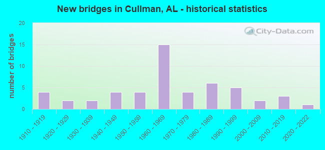
- New bridges - historical statistics
- 41910-1919
- 21920-1929
- 21930-1939
- 41940-1949
- 41950-1959
- 151960-1969
- 41970-1979
- 61980-1989
- 51990-1999
- 22000-2009
- 32010-2019
- 12020-2022
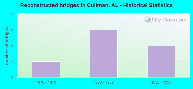
- Reconstructed bridges - Historical Statistics
- 11970-1979
- 31980-1989
- 21990-1999
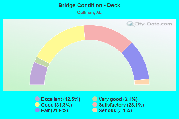
- Bridge Condition - Deck
- 12.5%Excellent
- 3.1%Very good
- 31.3%Good
- 28.1%Satisfactory
- 21.9%Fair
- 3.1%Serious
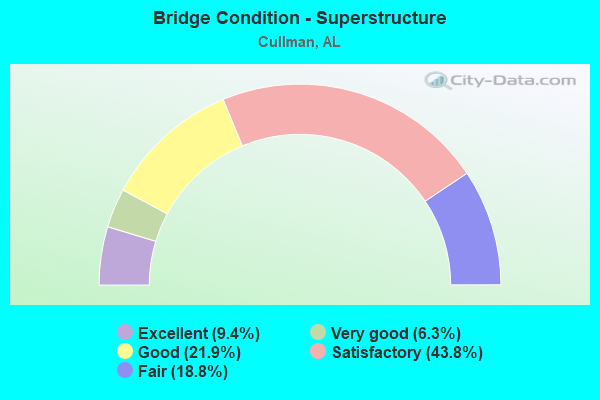
- Bridge Condition - Superstructure
- 9.4%Excellent
- 6.3%Very good
- 21.9%Good
- 43.8%Satisfactory
- 18.8%Fair
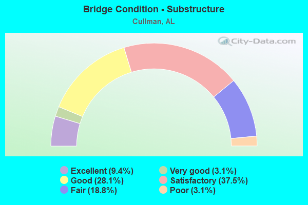
- Bridge Condition - Substructure
- 9.4%Excellent
- 3.1%Very good
- 28.1%Good
- 37.5%Satisfactory
- 18.8%Fair
- 3.1%Poor
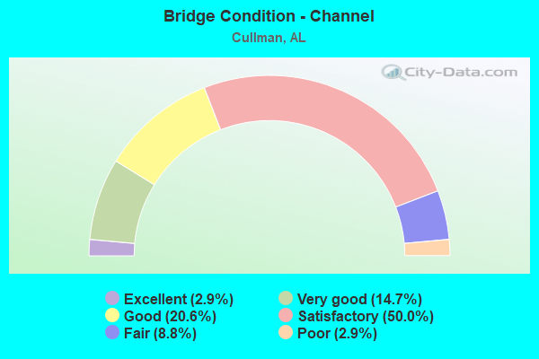
- Bridge Condition - Channel
- 2.9%Excellent
- 14.7%Very good
- 20.6%Good
- 50.0%Satisfactory
- 8.8%Fair
- 2.9%Poor
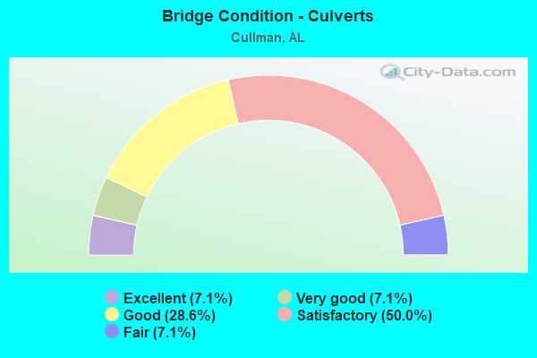
- Bridge Condition - Culverts
- 7.1%Excellent
- 7.1%Very good
- 28.6%Good
- 50.0%Satisfactory
- 7.1%Fair
Find on map >> Show street view
Structure Number: 18642, Location: .7MI E JCT SR157*US278 (Lat: 34.182778, Lng: -86.773664), Route carried "on" structure: US 278, Year Built: 1997, Status: Open, Structure Length: 7.10m (23.29ft), Average Daily Traffic: 8,532 (year 2020), Truck Traffic: 8%, Average Future Daily Traffic: 11,945 (year 2040), Design Load: HS 20, Features Intersected: BRINDLEY CREEK
Minimum Vertical Clearance: 30+ m (98+ ft), Kilometerpoint: 134.255, Lanes on structure: 2, Base Highway Network: Yes, Owner: State Highway Agency, Approaching Roadway Width: 13.1m (43.0ft), Skew: 10 degrees, Material/Design: Prestressed concrete, Design/Construction: Stringer/Multi-beam, Number Of Spans In Main Unit: 1, Number Of Approach Spans: 2, Length of Maximum Span: 38.1m (125.0ft), Curb-To-Curb Width: 12.1m (39.7ft), Out-to-Out Width: 13.0m (42.7ft)
Condition: Deck: Good, Superstructure: Good, Substructure: Good, Channel: Very good, Operating Rating: 70.1 metric tons, Method Used To Determine Operating Rating: Load Factor (LF), Inventory Rating: 42.5 metric tons, Method Used To Determine Inventory Rating: Load Factor (LF), Structural Evaluation: Better than present minimum criteria, Deck Geometry: Better than present minimum criteria, Waterway Adequacy: Equal to present desirable criteria, Approach Roadway Alignment: Equal to present desirable criteria, Length Of Structure Improvement: 8.13m (26.67ft), Designated Inspection Frequency: Every 24 months, Inspection Date: November 2021, Bridge Improvement Cost: $2,341,000, Roadway Improvement Cost: $234,000, Total Project Cost: $2,575,000 ( Estimate for 2022), Deck Structure Type: Concrete Cast-file-Place
Find on map >> Show street view
Structure Number: 18895, Location: CR 1442 (Lat: 34.283744, Lng: -86.828192), Route carried "on" structure: County highway 1442, Year Built: 2004, Status: Open, Structure Length: 1.77m (5.81ft), Average Daily Traffic: 200 (year 2018), Truck Traffic: 3%, Average Future Daily Traffic: 280 (year 2036), Design Load: HS 20, Features Intersected: FLINT CREEK
Minimum Vertical Clearance: 0.00m, Kilometerpoint: 0.000, Lanes on structure: 2, Owner: County Highway Agency, Approaching Roadway Width: 7.9m (25.9ft), Material/Design: Concrete, Design/Construction: Culvert, Number Of Spans In Main Unit: 4, Length of Maximum Span: 0.0m
Condition: Channel: Very good, Culverts: Very good, Operating Rating: 39.9 metric tons, Method Used To Determine Operating Rating: Load Factor (LF), Inventory Rating: 23.9 metric tons, Method Used To Determine Inventory Rating: Load Factor (LF), Structural Evaluation: Equal to present minimum criteria, Waterway Adequacy: Superior to present desirable criteria, Approach Roadway Alignment: Equal to present desirable criteria, Length Of Structure Improvement: 2.47m (8.10ft), Designated Inspection Frequency: Every 24 months, Inspection Date: September 2020, Bridge Improvement Cost: $1,128,000, Roadway Improvement Cost: $113,000, Total Project Cost: $1,241,000 ( Estimate for 2022), Wearing Surface/Protective System: Wearing Surface: Bituminous
Find on map >> Show street view
Structure Number: 18912, Location: Cr 1301 (Lat: 34.225336, Lng: -86.850661), Route carried "on" structure: County highway 1301, Year Built: 2004, Status: Open, Structure Length: 4.88m (16.01ft), Average Daily Traffic: 440 (year 2018), Truck Traffic: 4%, Average Future Daily Traffic: 500 (year 2033), Design Load: HS 20, Features Intersected: CSX RAILROAD
Minimum Vertical Clearance: 0.00m, Kilometerpoint: 0.000, Lanes on structure: 2, Owner: County Highway Agency, Approaching Roadway Width: 7.9m (25.9ft), Material/Design: Prestressed concrete, Design/Construction: Stringer/Multi-beam, Number Of Spans In Main Unit: 3, Length of Maximum Span: 0.0m, Curb-To-Curb Width: 8.5m (27.9ft), Out-to-Out Width: 9.4m (30.8ft)
Condition: Deck: Excellent, Superstructure: Excellent, Substructure: Excellent, Operating Rating: 59.6 metric tons, Method Used To Determine Operating Rating: Load Factor (LF), Inventory Rating: 35.7 metric tons, Method Used To Determine Inventory Rating: Load Factor (LF), Structural Evaluation: Superior to present desirable criteria, Deck Geometry: High priority of corrective action, Approach Roadway Alignment: Equal to present desirable criteria, Length Of Structure Improvement: 5.89m (19.32ft), Designated Inspection Frequency: Every 24 months, Inspection Date: March 2021, Bridge Improvement Cost: $1,211,000, Roadway Improvement Cost: $121,000, Total Project Cost: $1,332,000 ( Estimate for 2022), Deck Structure Type: Concrete Cast-file-Place
Find on map >> Show street view
Structure Number: 19744, Location: 1.1 MI E JCT US 31 (Lat: 34.193333, Lng: -86.838333), Route carried "on" structure: City street , Year Built: 2020, Status: Open, Structure Length: 1.73m (5.68ft), Average Daily Traffic: 5,400 (year 2022), Average Future Daily Traffic: 8,000 (year 2042), Design Load: HS 20, Features Intersected: Bridge Creek, Facility Carried by Structure: Co Rt 35
Minimum Vertical Clearance: 30+ m (98+ ft), Kilometerpoint: 1.770, Lanes on structure: 2, Owner: City or Municipal Highway Agency, Approaching Roadway Width: 7.3m (24.0ft), Material/Design: Concrete, Design/Construction: Arch - Deck, Number Of Spans In Main Unit: 1, Length of Maximum Span: 16.5m (54.1ft), Curb-To-Curb Width: 7.3m (24.0ft), Out-to-Out Width: 12.2m (40.0ft)
Condition: Deck: Excellent, Superstructure: Excellent, Substructure: Excellent, Channel: Very good, Operating Rating: 72.8 metric tons, Method Used To Determine Operating Rating: Load Factor (LF), Inventory Rating: 43.1 metric tons, Method Used To Determine Inventory Rating: Load Factor (LF), Structural Evaluation: Superior to present desirable criteria, Deck Geometry: High priority of replacement, Waterway Adequacy: Meets minimum limits, Approach Roadway Alignment: Equal to present minimum criteria, Length Of Structure Improvement: 2.43m (7.97ft), Designated Inspection Frequency: Every 24 months, Inspection Date: January 2022, Bridge Improvement Cost: $665,000, Roadway Improvement Cost: $67,000, Total Project Cost: $732,000 ( Estimate for 2022), Deck Structure Type: Other, Wearing Surface/Protective System: Wearing Surface: Bituminous
Find on map >> Show street view
Structure Number: 20682, Location: .5 EAST OF AL157/74 (Lat: 34.306972, Lng: -87.293486), Route carried "on" structure: US 278, Year Built: 2019, Status: Open, Structure Length: 7.13m (23.39ft), Average Daily Traffic: 11,568 (year 2020), Truck Traffic: 8%, Average Future Daily Traffic: 16,195 (year 2040), Design Load: HL 93, Features Intersected: Brindle Creek
Minimum Vertical Clearance: 30+ m (98+ ft), Kilometerpoint: 134.211, Lanes on structure: 2, Base Highway Network: Yes, Owner: State Highway Agency, Approaching Roadway Width: 11.6m (38.1ft), Material/Design: Concrete, Design/Construction: Stringer/Multi-beam, Number Of Spans In Main Unit: 3, Number Of Approach Spans: 2, Length of Maximum Span: 37.8m (124.0ft), Curb-To-Curb Width: 15.8m (51.8ft), Out-to-Out Width: 16.8m (55.1ft)
Condition: Deck: Excellent, Superstructure: Very good, Substructure: Very good, Channel: Satisfactory, Operating Rating: 80.6 metric tons, Method Used To Determine Operating Rating: Load and Resistance Factor (LRFR), Inventory Rating: 44.5 metric tons, Method Used To Determine Inventory Rating: Load and Resistance Factor (LRFR), Structural Evaluation: Equal to present desirable criteria, Deck Geometry: Superior to present desirable criteria, Waterway Adequacy: Superior to present desirable criteria, Approach Roadway Alignment: Superior to present desirable criteria, Length Of Structure Improvement: 8.16m (26.77ft), Designated Inspection Frequency: Every 24 months, Inspection Date: October 2021, Bridge Improvement Cost: $3,079,000, Roadway Improvement Cost: $308,000, Total Project Cost: $3,387,000 ( Estimate for 2022), Deck Structure Type: Concrete Cast-file-Place
Find on map >> Show street view
Structure Number: 21206, Location: CR 483 (Lat: 34.112000, Lng: -86.814822), Route carried "on" structure: County highway 483, Year Built: 2015, Status: Open, Structure Length: 0.79m (2.59ft), Average Daily Traffic: 200 (year 2015), Truck Traffic: 1%, Average Future Daily Traffic: 256 (year 2035), Features Intersected: Loveless creek
Minimum Vertical Clearance: 30+ m (98+ ft), Kilometerpoint: 1.617, Lanes on structure: 2, Owner: County Highway Agency, Approaching Roadway Width: 5.5m (18.0ft), Material/Design: Concrete, Design/Construction: Culvert, Number Of Spans In Main Unit: 2, Length of Maximum Span: 3.7m (12.1ft), Out-to-Out Width: 7.2m (23.6ft)
Condition: Channel: Excellent, Culverts: Excellent, Operating Rating: 58.2 metric tons, Method Used To Determine Operating Rating: Load Factor (LF), Inventory Rating: 34.9 metric tons, Method Used To Determine Inventory Rating: Load Factor (LF), Structural Evaluation: Superior to present desirable criteria, Waterway Adequacy: Equal to present desirable criteria, Approach Roadway Alignment: Equal to present minimum criteria, Length Of Structure Improvement: 1.44m (4.72ft), Designated Inspection Frequency: Every 24 months, Inspection Date: September 2021, Bridge Improvement Cost: $208,000, Roadway Improvement Cost: $21,000, Total Project Cost: $229,000 ( Estimate for 2022), Deck Structure Type: Concrete Cast-file-Place
Find on map >> Show street view
Structure Number: 21357, Location: 0.1 Mi N Jct Larkwood (Lat: 34.190200, Lng: -86.809200), Route carried "on" structure: City street , Year Built: 2019, Status: Open, Structure Length: 2.74m (8.99ft), Average Daily Traffic: 600 (year 2020), Truck Traffic: 2%, Average Future Daily Traffic: 900 (year 2040), Design Load: HS 20, Features Intersected: EIGHTMILE CREEK, Facility Carried by Structure: Convent Rd NE
Minimum Vertical Clearance: 30.18m (99.02ft), Kilometerpoint: 0.010, Lanes on structure: 2, Owner: City or Municipal Highway Agency, Approaching Roadway Width: 7.3m (24.0ft), Material/Design: Concrete, Number Of Spans In Main Unit: 1, Length of Maximum Span: 27.4m (89.9ft), Curb-To-Curb Width: 7.3m (24.0ft), Out-to-Out Width: 9.4m (30.8ft)
Condition: Deck: Excellent, Superstructure: Excellent, Substructure: Excellent, Channel: Very good, Operating Rating: 53.7 metric tons, Method Used To Determine Operating Rating: Load Factor (LF), Inventory Rating: 32.2 metric tons, Method Used To Determine Inventory Rating: Load Factor (LF), Structural Evaluation: Better than present minimum criteria, Deck Geometry: Meets minimum limits, Waterway Adequacy: Better than present minimum criteria, Approach Roadway Alignment: Equal to present minimum criteria, Length Of Structure Improvement: 3.66m (12.01ft), Designated Inspection Frequency: Every 24 months, Inspection Date: September 2020, Bridge Improvement Cost: $754,000, Roadway Improvement Cost: $75,000, Total Project Cost: $829,000 ( Estimate for 2022), Deck Structure Type: Concrete Cast-file-Place, Wearing Surface/Protective System: Wearing Surface: Monolithic Concrete
Find on map >> Show street view
Structure Number: 57, Location: 0.1 MI E JCT US 31 (Lat: 34.141667, Lng: -86.825000), Route carried "under" structure: City street , Year Built: 1912, Structure Length: 0. m, Average Daily Traffic: 810 (year 1996), Truck Traffic: 10%, Features Intersected: L*N RR, Facility Carried by Structure: L*N RR
Minimum Vertical Clearance: 3.10m (10.17ft), Kilometerpoint: 0.010, Lanes under structure: 1, Material/Design: Concrete, Design/Construction: Arch - Deck, Length of Maximum Span: 11.3m (37.1ft)
Find on map >> Show street view
Structure Number: 65, Location: 0.1 MI N JCT US 31 (Lat: 34.138333, Lng: -86.823333), Route carried "under" structure: City street , Year Built: 1912, Structure Length: 0. m, Average Daily Traffic: 870 (year 1996), Truck Traffic: 1%, Features Intersected: L*N RR, Facility Carried by Structure: L*N RR
Minimum Vertical Clearance: 3.25m (10.66ft), Kilometerpoint: 0.010, Lanes under structure: 1, Material/Design: Concrete continuous, Design/Construction: Stringer/Multi-beam, Length of Maximum Span: 13.4m (44.0ft)
Find on map >> Show street view
Structure Number: 7092, Location: JCT I-65 * US 278 (Lat: 34.170581, Lng: -86.874875), Route carried "under" structure: Interstate 65, Year Built: 1960, Structure Length: 0. m, Average Daily Traffic: 46,822 (year 2018), Truck Traffic: 26%, Features Intersected: I-65, Facility Carried by Structure: US 278; SR 74
Minimum Vertical Clearance: 5.21m (17.09ft), Kilometerpoint: 494.788, Lanes on structure: 3, Lanes under structure: 4, Material/Design: Concrete continuous, Design/Construction: Tee Beam, Length of Maximum Span: 22.3m (73.2ft)
Find on map >> Show street view
Structure Number: 7093, Location: JCT I-65 * US 278 (Lat: 34.170361, Lng: -86.874908), Route carried "under" structure: Interstate 65, Year Built: 1960, Structure Length: 0. m, Average Daily Traffic: 46,882 (year 2018), Truck Traffic: 26%, Features Intersected: I-65, Facility Carried by Structure: US 278; SR 74
Minimum Vertical Clearance: 5.21m (17.09ft), Kilometerpoint: 494.772, Lanes on structure: 3, Lanes under structure: 4, Material/Design: Concrete continuous, Design/Construction: Tee Beam, Length of Maximum Span: 22.3m (73.2ft)
Find on map >> Show street view
Structure Number: 857, Location: 1 MI N JCT US 278 * I65 (Lat: 34.189161, Lng: -86.878361), Route carried "under" structure: Interstate 65, Year Built: 1965, Structure Length: 0. m, Average Daily Traffic: 45,118 (year 2020), Truck Traffic: 26%, Features Intersected: I65, Facility Carried by Structure: CO RD 1169 MP308.8
Minimum Vertical Clearance: 4.94m (16.21ft), Kilometerpoint: 496.867, Lanes on structure: 2, Lanes under structure: 4, Material/Design: Concrete continuous, Design/Construction: Tee Beam, Length of Maximum Span: 29.3m (96.1ft)
Find on map >> Show street view
Structure Number: 15027, Location: JCT I65 * SR 157 (Lat: 34.207439, Lng: -86.878372), Route carried "under" structure: Interstate 65, Year Built: 1965, Structure Length: 0. m, Average Daily Traffic: 45,118 (year 2020), Truck Traffic: 26%, Features Intersected: I65, Facility Carried by Structure: AL 157
Minimum Vertical Clearance: 4.85m (15.91ft), Kilometerpoint: 499.003, Lanes on structure: 5, Lanes under structure: 4, Material/Design: Concrete continuous, Design/Construction: Tee Beam, Length of Maximum Span: 25.0m (82.0ft)