Bridge Statistics for Dale, Indiana (IN)
Condition, Traffic, Stress, Structural Evaluation, Project Costs
- National Bridge Inventory (NBI) Statistics
- 39Number of bridges
- 341ft / 104mTotal length
- $474,000Total costs
- 170,927Total average daily traffic
- 28,352Total average daily truck traffic
- National Bridge Inventory (NBI) Registered Bridges for Dale
- No street view available for this location
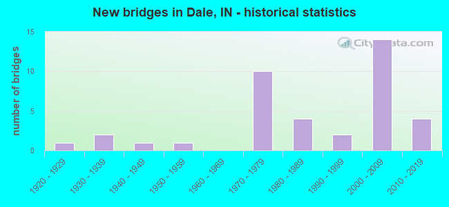
- New bridges - historical statistics
- 11920-1929
- 21930-1939
- 11940-1949
- 11950-1959
- 101970-1979
- 41980-1989
- 21990-1999
- 142000-2009
- 42010-2019

- Reconstructed bridges - Historical Statistics
- 11970-1979
- 01980-1989
- 11990-1999
- 22000-2009
- 42010-2019


- Bridge Condition - Deck
- 7.4%Very good
- 51.9%Good
- 33.3%Satisfactory
- 7.4%Fair

- Bridge Condition - Superstructure
- 11.1%Very good
- 63.0%Good
- 14.8%Satisfactory
- 7.4%Fair
- 3.7%Poor

- Bridge Condition - Substructure
- 22.2%Very good
- 51.9%Good
- 11.1%Satisfactory
- 14.8%Fair

- Bridge Condition - Channel
- 43.5%Very good
- 13.0%Good
- 21.7%Satisfactory
- 21.7%Fair

- Bridge Condition - Culverts
- 50.0%Good
- 50.0%Satisfactory
Find on map >> Show street view
Structure Number: 2217, Location: 00.13 W SR 245 (Lat: 38.166339, Lng: -86.974069), Route carried "on" structure: State highway 62, Year Built: 1930, Year Reconstructed: 1984, Status: Open, Structure Length: 2.68m (8.79ft), Average Daily Traffic: 4,440 (year 2004), Truck Traffic: 10%, Average Future Daily Traffic: 7,371 (year 2032), Design Load: H 20, Features Intersected: BALLARD BRANCH
Minimum Vertical Clearance: 30+ m (98+ ft), Kilometerpoint: 5.713, Lanes on structure: 2, Owner: State Highway Agency, Approaching Roadway Width: 13.4m (44.0ft), Material/Design: Concrete, Design/Construction: Culvert, Number Of Spans In Main Unit: 1, Length of Maximum Span: 16.0m (52.5ft), Curb or Sidewalk Widths: Left: 0.1m (0.3ft), Right: 0.1m (0.3ft), Curb-To-Curb Width: 13.4m (44.0ft), Out-to-Out Width: 14.3m (46.9ft)
Condition: Channel: Good, Culverts: Satisfactory, Operating Rating: 65.6 metric tons, Method Used To Determine Operating Rating: Field evaluation and documented engineering judgment, Inventory Rating: 39.4 metric tons, Method Used To Determine Inventory Rating: Field evaluation and documented engineering judgment, Structural Evaluation: Equal to present minimum criteria, Deck Geometry: Better than present minimum criteria, Waterway Adequacy: Equal to present desirable criteria, Approach Roadway Alignment: Equal to present desirable criteria, Designated Inspection Frequency: Every 24 months, Inspection Date: March 2021
Find on map >> Show street view
Structure Number: 24531, Location: 00.12 W SR 161 (Lat: 38.203989, Lng: -87.092061), Route carried "on" structure: State highway 68, Year Built: 2016, Status: Open, Structure Length: 0.96m (3.15ft), Average Daily Traffic: 940 (year 2015), Truck Traffic: 5%, Average Future Daily Traffic: 1,039 (year 2035), Design Load: HL 93, Features Intersected: LITTLE RED CREEK
Minimum Vertical Clearance: 30+ m (98+ ft), Kilometerpoint: 33.201, Lanes on structure: 2, Owner: State Highway Agency, Approaching Roadway Width: 8.5m (27.9ft), Skew: 4 degrees, Material/Design: Concrete, Design/Construction: Culvert, Number Of Spans In Main Unit: 1, Length of Maximum Span: 7.3m (24.0ft), Curb-To-Curb Width: 8.5m (27.9ft), Out-to-Out Width: 9.4m (30.8ft)
Condition: Channel: Good, Culverts: Satisfactory, Operating Rating: 56.4 metric tons, Method Used To Determine Operating Rating: Load and Resistance Factor Rating (LRFR) rating reported by rating factor(RF) method using HL-93 loadings, Inventory Rating: 43.4 metric tons, Method Used To Determine Inventory Rating: Load and Resistance Factor Rating (LRFR) rating reported by rating factor(RF) method using HL-93 loadings, Structural Evaluation: Equal to present minimum criteria, Deck Geometry: Somewhat better than minimum adequacy, Waterway Adequacy: Superior to present desirable criteria, Approach Roadway Alignment: Equal to present desirable criteria, Designated Inspection Frequency: Every 24 months, Inspection Date: July 2021
Find on map >> Show street view
Structure Number: 2455, Location: 00.95 E SR 161 (Lat: 38.186581, Lng: -87.017781), Route carried "on" structure: State highway 68, Year Built: 1932, Status: Posted for load, Structure Length: 0.91m (2.99ft), Average Daily Traffic: 1,402 (year 2004), Truck Traffic: 10%, Average Future Daily Traffic: 2,329 (year 2032), Features Intersected: WALLACE FORK
Minimum Vertical Clearance: 30+ m (98+ ft), Kilometerpoint: 40.443, Lanes on structure: 2, Owner: State Highway Agency, Approaching Roadway Width: 7.9m (25.9ft), Skew: 1 degrees, Material/Design: Concrete, Design/Construction: Stringer/Multi-beam, Number Of Spans In Main Unit: 1, Length of Maximum Span: 8.5m (27.9ft), Curb-To-Curb Width: 8.5m (27.9ft), Out-to-Out Width: 9.1m (29.9ft)
Condition: Deck: Fair, Superstructure: Poor, Substructure: Fair, Channel: Fair, Operating Rating: 28.2 metric tons, Method Used To Determine Operating Rating: Load and Resistance Factor Rating (LRFR) rating reported by rating factor(RF) method using HL-93 loadings, Inventory Rating: 21.7 metric tons, Method Used To Determine Inventory Rating: Load and Resistance Factor Rating (LRFR) rating reported by rating factor(RF) method using HL-93 loadings, Structural Evaluation: Meets minimum limits, Deck Geometry: Somewhat better than minimum adequacy, Waterway Adequacy: Better than present minimum criteria, Approach Roadway Alignment: Equal to present minimum criteria, Bridge Posting: Required (Relationship of Operating Rating to Maximum Legal Load: 0.1 - 9.9% below), Designated Inspection Frequency: Every 12 months, Inspection Date: July 2021, Deck Structure Type: Concrete Cast-file-Place, Wearing Surface/Protective System: Wearing Surface: Bituminous
Find on map >> Show street view
Structure Number: 2456, Location: 01.15 E SR 161 (Lat: 38.185219, Lng: -87.015100), Route carried "on" structure: State highway 68, Year Built: 2000, Status: Open, Structure Length: 3.23m (10.60ft), Average Daily Traffic: 1,180 (year 2020), Truck Traffic: 5%, Average Future Daily Traffic: 1,720 (year 2040), Design Load: HS 20, Features Intersected: N FORK LITTLE PIGEON CRE
Minimum Vertical Clearance: 30+ m (98+ ft), Kilometerpoint: 0.241, Lanes on structure: 2, Owner: State Highway Agency, Approaching Roadway Width: 8.5m (27.9ft), Skew: 3 degrees, Material/Design: Concrete continuous, Design/Construction: Slab, Number Of Spans In Main Unit: 3, Length of Maximum Span: 12.0m (39.4ft), Curb-To-Curb Width: 8.8m (28.9ft), Out-to-Out Width: 9.8m (32.2ft)
Condition: Deck: Good, Superstructure: Good, Substructure: Very good, Channel: Very good, Operating Rating: 58.3 metric tons, Method Used To Determine Operating Rating: Load and Resistance Factor Rating (LRFR) rating reported by rating factor(RF) method using HL-93 loadings, Inventory Rating: 45.0 metric tons, Method Used To Determine Inventory Rating: Load and Resistance Factor Rating (LRFR) rating reported by rating factor(RF) method using HL-93 loadings, Structural Evaluation: Better than present minimum criteria, Deck Geometry: Somewhat better than minimum adequacy, Waterway Adequacy: Equal to present desirable criteria, Approach Roadway Alignment: Equal to present desirable criteria, Designated Inspection Frequency: Every 24 months, Inspection Date: July 2021, Deck Structure Type: Concrete Cast-file-Place, Wearing Surface/Protective System: Wearing Surface: Epoxy Overlay, Deck Protection: Epoxy Coated Reinforcing
Find on map >> Show street view
Structure Number: 28324, Location: 00.75 E SR 161 (Lat: 38.199911, Lng: -87.077989), Route carried "on" structure: State highway 68, Year Built: 1972, Year Reconstructed: 2000, Status: Open, Structure Length: 6.64m (21.78ft), Average Daily Traffic: 1,064 (year 2021), Truck Traffic: 7%, Average Future Daily Traffic: 1,927 (year 2032), Design Load: HS 20, Features Intersected: I-64 EB/WB
Minimum Vertical Clearance: 30+ m (98+ ft), Kilometerpoint: 34.601, Lanes on structure: 2, Lanes under structure: 4, Owner: State Highway Agency, Approaching Roadway Width: 8.5m (27.9ft), Skew: 1 degrees, Material/Design: Steel continuous, Design/Construction: Stringer/Multi-beam, Number Of Spans In Main Unit: 2, Length of Maximum Span: 32.6m (107.0ft), Curb-To-Curb Width: 12.8m (42.0ft), Out-to-Out Width: 13.7m (44.9ft)
Condition: Deck: Satisfactory, Superstructure: Good, Substructure: Good, Operating Rating: 44.4 metric tons, Method Used To Determine Operating Rating: Load and Resistance Factor Rating (LRFR) rating reported by rating factor(RF) method using HL-93 loadings, Inventory Rating: 34.0 metric tons, Method Used To Determine Inventory Rating: Load and Resistance Factor Rating (LRFR) rating reported by rating factor(RF) method using HL-93 loadings, Structural Evaluation: Better than present minimum criteria, Deck Geometry: Better than present minimum criteria, Underclear: Meets minimum limits, Approach Roadway Alignment: Equal to present desirable criteria, Designated Inspection Frequency: Every 24 months, Inspection Date: July 2021, Deck Structure Type: Concrete Cast-file-Place, Wearing Surface/Protective System: Wearing Surface: Latex Concrete
Find on map >> Show street view
Structure Number: 338, Location: 01.57 E SR 161 (Lat: 38.196311, Lng: -87.008689), Route carried "on" structure: Interstate 64, Year Built: 1972, Year Reconstructed: 2018, Status: Open, Structure Length: 2.44m (8.01ft), Average Daily Traffic: 15,040 (year 2016), Truck Traffic: 36%, Average Future Daily Traffic: 17,500 (year 2036), Design Load: HS 20+Mod, Features Intersected: N FORK PIGEON CREEK
Minimum Vertical Clearance: 30+ m (98+ ft), Kilometerpoint: 88.369, Lanes on structure: 2, Base Highway Network: Yes (, Subroute: 1), Owner: State Highway Agency, Approaching Roadway Width: 12.2m (40.0ft), Material/Design: Concrete continuous, Design/Construction: Slab, Number Of Spans In Main Unit: 3, Length of Maximum Span: 9.1m (29.9ft), Curb-To-Curb Width: 12.0m (39.4ft), Out-to-Out Width: 13.0m (42.7ft)
Condition: Deck: Good, Superstructure: Good, Substructure: Good, Channel: Very good, Operating Rating: 36.0 metric tons, Method Used To Determine Operating Rating: Load and Resistance Factor Rating (LRFR) rating reported by rating factor(RF) method using HL-93 loadings, Inventory Rating: 27.9 metric tons, Method Used To Determine Inventory Rating: Load and Resistance Factor Rating (LRFR) rating reported by rating factor(RF) method using HL-93 loadings, Structural Evaluation: Better than present minimum criteria, Deck Geometry: Equal to present minimum criteria, Waterway Adequacy: Equal to present desirable criteria, Approach Roadway Alignment: Equal to present desirable criteria, Designated Inspection Frequency: Every 24 months, Inspection Date: March 2022, Deck Structure Type: Concrete Cast-file-Place, Wearing Surface/Protective System: Wearing Surface: Other
Find on map >> Show street view
Structure Number: 3381, Location: 01.57 E SR 161 (Lat: 38.196981, Lng: -87.008581), Route carried "on" structure: Interstate 64, Year Built: 1972, Year Reconstructed: 2018, Status: Open, Structure Length: 2.44m (8.01ft), Average Daily Traffic: 15,040 (year 2016), Truck Traffic: 36%, Average Future Daily Traffic: 17,500 (year 2036), Design Load: HS 20+Mod, Features Intersected: N FORK PIGEON CREEK
Minimum Vertical Clearance: 30+ m (98+ ft), Kilometerpoint: 88.369, Lanes on structure: 2, Base Highway Network: Yes (, Subroute: 1), Owner: State Highway Agency, Approaching Roadway Width: 12.2m (40.0ft), Material/Design: Concrete continuous, Design/Construction: Slab, Number Of Spans In Main Unit: 3, Length of Maximum Span: 9.1m (29.9ft), Curb-To-Curb Width: 12.0m (39.4ft), Out-to-Out Width: 13.0m (42.7ft)
Condition: Deck: Good, Superstructure: Good, Substructure: Very good, Channel: Very good, Operating Rating: 36.0 metric tons, Method Used To Determine Operating Rating: Load and Resistance Factor Rating (LRFR) rating reported by rating factor(RF) method using HL-93 loadings, Inventory Rating: 27.9 metric tons, Method Used To Determine Inventory Rating: Load and Resistance Factor Rating (LRFR) rating reported by rating factor(RF) method using HL-93 loadings, Structural Evaluation: Better than present minimum criteria, Deck Geometry: Equal to present minimum criteria, Waterway Adequacy: Equal to present desirable criteria, Approach Roadway Alignment: Equal to present desirable criteria, Designated Inspection Frequency: Every 24 months, Inspection Date: March 2022, Deck Structure Type: Concrete Cast-file-Place, Wearing Surface/Protective System: Wearing Surface: Other
Find on map >> Show street view
Structure Number: 33814, Location: 00.33 W US 231 (Lat: 38.194781, Lng: -86.986731), Route carried "on" structure: Interstate 64, Year Built: 2008, Status: Open, Structure Length: 2.11m (6.92ft), Average Daily Traffic: 5,500 (year 2008), Truck Traffic: 20%, Average Future Daily Traffic: 7,500 (year 2032), Design Load: HS 20, Features Intersected: BR N FK LITL PIGEON CR
Minimum Vertical Clearance: 30+ m (98+ ft), Kilometerpoint: 89.721, Lanes on structure: 1, Base Highway Network: Yes (, Subroute: 1), Owner: State Highway Agency, Approaching Roadway Width: 11.9m (39.0ft), Skew: 1 degrees, Material/Design: Prestressed concrete, Design/Construction: Stringer/Multi-beam, Number Of Spans In Main Unit: 1, Length of Maximum Span: 20.6m (67.6ft), Curb-To-Curb Width: 12.1m (39.7ft), Out-to-Out Width: 13.0m (42.7ft)
Condition: Deck: Good, Superstructure: Very good, Substructure: Good, Channel: Very good, Operating Rating: 51.8 metric tons, Method Used To Determine Operating Rating: Load and Resistance Factor Rating (LRFR) rating reported by rating factor(RF) method using HL-93 loadings, Inventory Rating: 40.2 metric tons, Method Used To Determine Inventory Rating: Load and Resistance Factor Rating (LRFR) rating reported by rating factor(RF) method using HL-93 loadings, Structural Evaluation: Better than present minimum criteria, Deck Geometry: Somewhat better than minimum adequacy, Waterway Adequacy: Equal to present desirable criteria, Approach Roadway Alignment: Equal to present desirable criteria, Designated Inspection Frequency: Every 24 months, Inspection Date: March 2022, Deck Structure Type: Concrete Cast-file-Place, Wearing Surface/Protective System: Wearing Surface: Epoxy Overlay, Deck Protection: Epoxy Coated Reinforcing
Find on map >> Show street view
Structure Number: 33815, Location: 00.33 W US 231 (Lat: 38.195031, Lng: -86.986731), Route carried "on" structure: Interstate 64, Year Built: 2008, Status: Open, Structure Length: 2.11m (6.92ft), Average Daily Traffic: 5,500 (year 2008), Truck Traffic: 20%, Average Future Daily Traffic: 7,500 (year 2032), Design Load: HS 20, Features Intersected: BR N FK LITL PIGEON CR
Minimum Vertical Clearance: 30+ m (98+ ft), Kilometerpoint: 89.721, Lanes on structure: 2, Base Highway Network: Yes (, Subroute: 1), Owner: State Highway Agency, Approaching Roadway Width: 11.9m (39.0ft), Skew: 1 degrees, Material/Design: Prestressed concrete, Design/Construction: Stringer/Multi-beam, Number Of Spans In Main Unit: 1, Length of Maximum Span: 20.6m (67.6ft), Curb-To-Curb Width: 12.1m (39.7ft), Out-to-Out Width: 13.0m (42.7ft)
Condition: Deck: Very good, Superstructure: Good, Substructure: Very good, Channel: Very good, Operating Rating: 51.8 metric tons, Method Used To Determine Operating Rating: Load and Resistance Factor Rating (LRFR) rating reported by rating factor(RF) method using HL-93 loadings, Inventory Rating: 40.2 metric tons, Method Used To Determine Inventory Rating: Load and Resistance Factor Rating (LRFR) rating reported by rating factor(RF) method using HL-93 loadings, Structural Evaluation: Better than present minimum criteria, Deck Geometry: Equal to present minimum criteria, Waterway Adequacy: Equal to present desirable criteria, Approach Roadway Alignment: Equal to present desirable criteria, Designated Inspection Frequency: Every 24 months, Inspection Date: March 2022, Deck Structure Type: Concrete Cast-file-Place, Wearing Surface/Protective System: Wearing Surface: Epoxy Overlay, Deck Protection: Epoxy Coated Reinforcing
Find on map >> Show street view
Structure Number: 33816, Location: 00.63 W US 231 (Lat: 38.193689, Lng: -86.987050), Route carried "on" structure: Ramp Interstate 64, Year Built: 2008, Status: Open, Structure Length: 2.99m (9.81ft), Average Daily Traffic: 500 (year 2008), Truck Traffic: 11%, Average Future Daily Traffic: 700 (year 2032), Design Load: HS 20, Features Intersected: BR N FK LITL PIGEON CR
Minimum Vertical Clearance: 30+ m (98+ ft), Kilometerpoint: 88.369, Lanes on structure: 1, Base Highway Network: Yes (, Subroute: 1), Owner: State Highway Agency, Approaching Roadway Width: 9.1m (29.9ft), Skew: 1 degrees, Material/Design: Prestressed concrete, Design/Construction: Tee Beam, Number Of Spans In Main Unit: 1, Length of Maximum Span: 29.4m (96.5ft), Curb-To-Curb Width: 9.2m (30.2ft), Out-to-Out Width: 10.1m (33.1ft)
Condition: Deck: Good, Superstructure: Good, Substructure: Very good, Channel: Very good, Operating Rating: 59.6 metric tons, Method Used To Determine Operating Rating: Load and Resistance Factor Rating (LRFR) rating reported by rating factor(RF) method using HL-93 loadings, Inventory Rating: 46.0 metric tons, Method Used To Determine Inventory Rating: Load and Resistance Factor Rating (LRFR) rating reported by rating factor(RF) method using HL-93 loadings, Structural Evaluation: Better than present minimum criteria, Deck Geometry: Superior to present desirable criteria, Waterway Adequacy: Equal to present desirable criteria, Approach Roadway Alignment: Equal to present desirable criteria, Designated Inspection Frequency: Every 24 months, Inspection Date: March 2022, Deck Structure Type: Concrete Cast-file-Place, Wearing Surface/Protective System: Wearing Surface: Epoxy Overlay, Deck Protection: Epoxy Coated Reinforcing
Find on map >> Show street view
Structure Number: 3382, Location: 00.59 E US 231 (Lat: 38.194039, Lng: -86.968169), Route carried "on" structure: Interstate 64, Year Built: 1972, Year Reconstructed: 2016, Status: Open, Structure Length: 6.13m (20.11ft), Average Daily Traffic: 6,869 (year 2004), Truck Traffic: 10%, Average Future Daily Traffic: 12,439 (year 2034), Design Load: HS 20+Mod, Features Intersected: SOUTHERN RR
Minimum Vertical Clearance: 30+ m (98+ ft), Kilometerpoint: 91.797, Lanes on structure: 2, Base Highway Network: Yes (, Subroute: 1), Owner: State Highway Agency, Approaching Roadway Width: 12.2m (40.0ft), Skew: 3 degrees, Material/Design: Steel continuous, Design/Construction: Stringer/Multi-beam, Number Of Spans In Main Unit: 3, Length of Maximum Span: 23.2m (76.1ft), Curb-To-Curb Width: 12.0m (39.4ft), Out-to-Out Width: 13.0m (42.7ft)
Condition: Deck: Satisfactory, Superstructure: Good, Substructure: Satisfactory, Operating Rating: 60.3 metric tons, Method Used To Determine Operating Rating: Load and Resistance Factor Rating (LRFR) rating reported by rating factor(RF) method using HL-93 loadings, Inventory Rating: 46.3 metric tons, Method Used To Determine Inventory Rating: Load and Resistance Factor Rating (LRFR) rating reported by rating factor(RF) method using HL-93 loadings, Structural Evaluation: Equal to present minimum criteria, Deck Geometry: Equal to present minimum criteria, Underclear: Superior to present desirable criteria, Approach Roadway Alignment: Equal to present desirable criteria, Designated Inspection Frequency: Every 24 months, Inspection Date: March 2022, Deck Structure Type: Concrete Cast-file-Place, Wearing Surface/Protective System: Wearing Surface: Latex Concrete
Find on map >> Show street view
Structure Number: 3383, Location: 00.59 E US 231 (Lat: 38.194281, Lng: -86.968019), Route carried "on" structure: Interstate 64, Year Built: 1972, Year Reconstructed: 2016, Status: Open, Structure Length: 6.13m (20.11ft), Average Daily Traffic: 13,310 (year 2013), Truck Traffic: 27%, Average Future Daily Traffic: 14,700 (year 2035), Design Load: HS 20+Mod, Features Intersected: SOUTHERN RR
Minimum Vertical Clearance: 30+ m (98+ ft), Kilometerpoint: 91.797, Lanes on structure: 2, Base Highway Network: Yes (, Subroute: 1), Owner: State Highway Agency, Approaching Roadway Width: 12.2m (40.0ft), Skew: 3 degrees, Material/Design: Steel continuous, Design/Construction: Stringer/Multi-beam, Number Of Spans In Main Unit: 3, Length of Maximum Span: 23.2m (76.1ft), Curb-To-Curb Width: 12.0m (39.4ft), Out-to-Out Width: 13.0m (42.7ft)
Condition: Deck: Good, Superstructure: Good, Substructure: Good, Operating Rating: 60.3 metric tons, Method Used To Determine Operating Rating: Load and Resistance Factor Rating (LRFR) rating reported by rating factor(RF) method using HL-93 loadings, Inventory Rating: 46.3 metric tons, Method Used To Determine Inventory Rating: Load and Resistance Factor Rating (LRFR) rating reported by rating factor(RF) method using HL-93 loadings, Structural Evaluation: Better than present minimum criteria, Deck Geometry: Equal to present minimum criteria, Underclear: Equal to present minimum criteria, Approach Roadway Alignment: Equal to present desirable criteria, Designated Inspection Frequency: Every 24 months, Inspection Date: March 2022, Deck Structure Type: Concrete Cast-file-Place, Wearing Surface/Protective System: Wearing Surface: Latex Concrete
Find on map >> Show street view
Structure Number: 3384, Location: 03.07 E US 231 (Lat: 38.199611, Lng: -86.922950), Route carried "on" structure: Alternate County highway , Year Built: 1972, Status: Open, Structure Length: 7.25m (23.79ft), Average Daily Traffic: 287 (year 2004), Truck Traffic: 10%, Average Future Daily Traffic: 476 (year 2032), Design Load: HS 20, Features Intersected: I-64 EB/WB, Facility Carried by Structure: SEC 2-1 RD/CR 700E
Minimum Vertical Clearance: 30+ m (98+ ft), Kilometerpoint: 0.000, Lanes on structure: 2, Lanes under structure: 4, Owner: State Highway Agency, Approaching Roadway Width: 7.9m (25.9ft), Material/Design: Steel continuous, Design/Construction: Stringer/Multi-beam, Number Of Spans In Main Unit: 2, Length of Maximum Span: 36.6m (120.1ft), Curb or Sidewalk Widths: Left: 0.1m (0.3ft), Right: 0.1m (0.3ft), Curb-To-Curb Width: 9.8m (32.2ft), Out-to-Out Width: 10.7m (35.1ft)
Condition: Deck: Good, Superstructure: Good, Substructure: Good, Operating Rating: 44.7 metric tons, Method Used To Determine Operating Rating: Load and Resistance Factor Rating (LRFR) rating reported by rating factor(RF) method using HL-93 loadings, Inventory Rating: 34.7 metric tons, Method Used To Determine Inventory Rating: Load and Resistance Factor Rating (LRFR) rating reported by rating factor(RF) method using HL-93 loadings, Structural Evaluation: Better than present minimum criteria, Deck Geometry: Better than present minimum criteria, Underclear: Somewhat better than minimum adequacy, Approach Roadway Alignment: Equal to present desirable criteria, Designated Inspection Frequency: Every 24 months, Inspection Date: March 2022, Deck Structure Type: Concrete Cast-file-Place, Wearing Surface/Protective System: Wearing Surface: Monolithic Concrete
Find on map >> Show street view
Structure Number: 7667, Location: 01.29 S SR 62 (Lat: 38.138569, Lng: -86.988361), Route carried "on" structure: US 231, Year Built: 2007, Status: Open, Structure Length: 3.19m (10.47ft), Average Daily Traffic: 4,800 (year 2008), Truck Traffic: 10%, Average Future Daily Traffic: 6,800 (year 2030), Design Load: HS 20, Features Intersected: HOOSIER SOUTHERN RR
Minimum Vertical Clearance: 30+ m (98+ ft), Kilometerpoint: 27.681, Lanes on structure: 2, Base Highway Network: Yes (, Subroute: 1), Owner: State Highway Agency, Approaching Roadway Width: 12.8m (42.0ft), Skew: 3 degrees, Material/Design: Prestressed concrete, Design/Construction: Tee Beam, Number Of Spans In Main Unit: 1, Length of Maximum Span: 31.0m (101.7ft), Curb-To-Curb Width: 12.1m (39.7ft), Out-to-Out Width: 13.0m (42.7ft)
Condition: Deck: Satisfactory, Superstructure: Good, Substructure: Good, Operating Rating: 65.8 metric tons, Method Used To Determine Operating Rating: Load and Resistance Factor Rating (LRFR) rating reported by rating factor(RF) method using HL-93 loadings, Inventory Rating: 44.7 metric tons, Method Used To Determine Inventory Rating: Load and Resistance Factor Rating (LRFR) rating reported by rating factor(RF) method using HL-93 loadings, Structural Evaluation: Better than present minimum criteria, Deck Geometry: Better than present minimum criteria, Underclear: Equal to present desirable criteria, Approach Roadway Alignment: Equal to present desirable criteria, Designated Inspection Frequency: Every 24 months, Inspection Date: April 2021, Deck Structure Type: Concrete Cast-file-Place, Wearing Surface/Protective System: Wearing Surface: Monolithic Concrete, Deck Protection: Epoxy Coated Reinforcing
Find on map >> Show street view
Structure Number: 76672, Location: 01.29 S SR 62 (Lat: 38.138200, Lng: -86.988631), Route carried "on" structure: US 231, Year Built: 2010, Status: Open, Structure Length: 3.19m (10.47ft), Average Daily Traffic: 4,800 (year 2008), Truck Traffic: 10%, Average Future Daily Traffic: 6,800 (year 2030), Design Load: HS 20, Features Intersected: HOOSIER SOUTHERN RR
Minimum Vertical Clearance: 30+ m (98+ ft), Kilometerpoint: 27.681, Lanes on structure: 2, Base Highway Network: Yes (, Subroute: 1), Owner: State Highway Agency, Approaching Roadway Width: 12.8m (42.0ft), Skew: 3 degrees, Material/Design: Prestressed concrete, Design/Construction: Tee Beam, Number Of Spans In Main Unit: 1, Length of Maximum Span: 31.0m (101.7ft), Curb-To-Curb Width: 12.1m (39.7ft), Out-to-Out Width: 13.0m (42.7ft)
Condition: Deck: Good, Superstructure: Good, Substructure: Good, Operating Rating: 65.8 metric tons, Method Used To Determine Operating Rating: Load and Resistance Factor Rating (LRFR) rating reported by rating factor(RF) method using HL-93 loadings, Inventory Rating: 44.7 metric tons, Method Used To Determine Inventory Rating: Load and Resistance Factor Rating (LRFR) rating reported by rating factor(RF) method using HL-93 loadings, Structural Evaluation: Better than present minimum criteria, Deck Geometry: Better than present minimum criteria, Underclear: Equal to present desirable criteria, Approach Roadway Alignment: Equal to present desirable criteria, Designated Inspection Frequency: Every 24 months, Inspection Date: April 2021, Deck Structure Type: Concrete Cast-file-Place, Wearing Surface/Protective System: Wearing Surface: Monolithic Concrete, Deck Protection: Epoxy Coated Reinforcing
Find on map >> Show street view
Structure Number: 76674, Location: 01.12 S SR 62 (Lat: 38.140619, Lng: -86.989961), Route carried "on" structure: US 231, Year Built: 2010, Status: Open, Structure Length: 7.99m (26.21ft), Average Daily Traffic: 4,800 (year 2008), Truck Traffic: 10%, Average Future Daily Traffic: 6,800 (year 2030), Design Load: HS 20, Features Intersected: LITTLE PIGEON CREEK
Minimum Vertical Clearance: 30+ m (98+ ft), Kilometerpoint: 28.139, Lanes on structure: 2, Base Highway Network: Yes (, Subroute: 1), Owner: State Highway Agency, Approaching Roadway Width: 12.8m (42.0ft), Skew: 2 degrees, Material/Design: Prestressed concrete continuous, Design/Construction: Tee Beam, Number Of Spans In Main Unit: 3, Length of Maximum Span: 30.0m (98.4ft), Curb-To-Curb Width: 12.1m (39.7ft), Out-to-Out Width: 13.0m (42.7ft)
Condition: Deck: Good, Superstructure: Good, Substructure: Good, Channel: Very good, Operating Rating: 46.7 metric tons, Method Used To Determine Operating Rating: Load and Resistance Factor Rating (LRFR) rating reported by rating factor(RF) method using HL-93 loadings, Inventory Rating: 31.4 metric tons, Method Used To Determine Inventory Rating: Load and Resistance Factor Rating (LRFR) rating reported by rating factor(RF) method using HL-93 loadings, Structural Evaluation: Better than present minimum criteria, Deck Geometry: Better than present minimum criteria, Waterway Adequacy: Superior to present desirable criteria, Approach Roadway Alignment: Equal to present desirable criteria, Designated Inspection Frequency: Every 24 months, Inspection Date: April 2021, Deck Structure Type: Concrete Cast-file-Place, Wearing Surface/Protective System: Wearing Surface: Monolithic Concrete, Deck Protection: Epoxy Coated Reinforcing
Find on map >> Show street view
Structure Number: 76676, Location: 01.12 S SR 62 (Lat: 38.140561, Lng: -86.990369), Route carried "on" structure: US 231, Year Built: 2008, Status: Open, Structure Length: 7.99m (26.21ft), Average Daily Traffic: 4,800 (year 2008), Truck Traffic: 10%, Average Future Daily Traffic: 6,800 (year 2030), Design Load: HS 20, Features Intersected: LITTLE PIGEON CREEK
Minimum Vertical Clearance: 30+ m (98+ ft), Kilometerpoint: 28.139, Lanes on structure: 2, Base Highway Network: Yes (, Subroute: 1), Owner: State Highway Agency, Approaching Roadway Width: 12.8m (42.0ft), Skew: 2 degrees, Material/Design: Prestressed concrete continuous, Design/Construction: Tee Beam, Number Of Spans In Main Unit: 3, Length of Maximum Span: 30.0m (98.4ft), Curb-To-Curb Width: 12.1m (39.7ft), Out-to-Out Width: 13.0m (42.7ft)
Condition: Deck: Satisfactory, Superstructure: Very good, Substructure: Good, Channel: Very good, Operating Rating: 47.6 metric tons, Method Used To Determine Operating Rating: Load and Resistance Factor Rating (LRFR) rating reported by rating factor(RF) method using HL-93 loadings, Inventory Rating: 36.6 metric tons, Method Used To Determine Inventory Rating: Load and Resistance Factor Rating (LRFR) rating reported by rating factor(RF) method using HL-93 loadings, Structural Evaluation: Better than present minimum criteria, Deck Geometry: Better than present minimum criteria, Waterway Adequacy: Superior to present desirable criteria, Approach Roadway Alignment: Equal to present desirable criteria, Designated Inspection Frequency: Every 24 months, Inspection Date: April 2021, Deck Structure Type: Concrete Cast-file-Place, Wearing Surface/Protective System: Wearing Surface: Monolithic Concrete, Deck Protection: Epoxy Coated Reinforcing
Find on map >> Show street view
Structure Number: 76688, Location: 00.80 N SR 68 (Lat: 38.179269, Lng: -86.992831), Route carried "on" structure: US 231, Year Built: 2008, Status: Open, Structure Length: 0.76m (2.49ft), Average Daily Traffic: 6,500 (year 2008), Truck Traffic: 12%, Average Future Daily Traffic: 9,000 (year 2030), Design Load: HS 20, Features Intersected: UNNAMED DITCH
Minimum Vertical Clearance: 30+ m (98+ ft), Kilometerpoint: 31.173, Lanes on structure: 4, Base Highway Network: Yes (, Subroute: 1), Owner: State Highway Agency, Approaching Roadway Width: 23.2m (76.1ft), Skew: 24 degrees, Material/Design: Concrete, Design/Construction: Culvert, Number Of Spans In Main Unit: 1, Length of Maximum Span: 6.9m (22.6ft), Curb-To-Curb Width: 23.3m (76.4ft), Out-to-Out Width: 47.2m (154.9ft)
Condition: Channel: Very good, Culverts: Good, Operating Rating: 54.5 metric tons, Method Used To Determine Operating Rating: Field evaluation and documented engineering judgment, Inventory Rating: 32.7 metric tons, Method Used To Determine Inventory Rating: Field evaluation and documented engineering judgment, Structural Evaluation: Better than present minimum criteria, Deck Geometry: Superior to present desirable criteria, Waterway Adequacy: Equal to present desirable criteria, Approach Roadway Alignment: Equal to present desirable criteria, Designated Inspection Frequency: Every 24 months, Inspection Date: April 2021
Find on map >> Show street view
Structure Number: 7669, Location: 02.01 N SR 68 (Lat: 38.194100, Lng: -86.982539), Route carried "on" structure: US 231, Year Built: 2008, Status: Open, Structure Length: 8.44m (27.69ft), Average Daily Traffic: 4,800 (year 2008), Truck Traffic: 10%, Average Future Daily Traffic: 6,800 (year 2030), Design Load: HS 20, Features Intersected: I-64 EB/WB
Minimum Vertical Clearance: 30+ m (98+ ft), Kilometerpoint: 34.730, Lanes on structure: 3, Lanes under structure: 6, Base Highway Network: Yes (, Subroute: 1), Owner: State Highway Agency, Approaching Roadway Width: 16.5m (54.1ft), Material/Design: Prestressed concrete continuous, Design/Construction: Tee Beam, Number Of Spans In Main Unit: 2, Length of Maximum Span: 42.0m (137.8ft), Curb-To-Curb Width: 15.7m (51.5ft), Out-to-Out Width: 16.6m (54.5ft)
Condition: Deck: Good, Superstructure: Good, Substructure: Good, Operating Rating: 41.5 metric tons, Method Used To Determine Operating Rating: Load and Resistance Factor Rating (LRFR) rating reported by rating factor(RF) method using HL-93 loadings, Inventory Rating: 32.1 metric tons, Method Used To Determine Inventory Rating: Load and Resistance Factor Rating (LRFR) rating reported by rating factor(RF) method using HL-93 loadings, Structural Evaluation: Better than present minimum criteria, Deck Geometry: Better than present minimum criteria, Underclear: Better than present minimum criteria, Approach Roadway Alignment: Equal to present desirable criteria, Designated Inspection Frequency: Every 24 months, Inspection Date: April 2021, Deck Structure Type: Concrete Cast-file-Place, Wearing Surface/Protective System: Wearing Surface: Epoxy Overlay, Deck Protection: Epoxy Coated Reinforcing
Find on map >> Show street view
Structure Number: 76692, Location: 02.01 N SR 68 (Lat: 38.194211, Lng: -86.982881), Route carried "on" structure: US 231, Year Built: 2008, Status: Open, Structure Length: 8.44m (27.69ft), Average Daily Traffic: 4,800 (year 2008), Truck Traffic: 10%, Average Future Daily Traffic: 6,800 (year 2030), Design Load: HS 20, Features Intersected: I-64 EB/WB
Minimum Vertical Clearance: 30+ m (98+ ft), Kilometerpoint: 34.730, Lanes on structure: 3, Lanes under structure: 6, Base Highway Network: Yes (, Subroute: 1), Owner: State Highway Agency, Approaching Roadway Width: 16.5m (54.1ft), Material/Design: Prestressed concrete continuous, Design/Construction: Tee Beam, Number Of Spans In Main Unit: 2, Length of Maximum Span: 42.0m (137.8ft), Curb-To-Curb Width: 15.7m (51.5ft), Out-to-Out Width: 16.6m (54.5ft)
Condition: Deck: Good, Superstructure: Good, Substructure: Good, Operating Rating: 41.5 metric tons, Method Used To Determine Operating Rating: Load and Resistance Factor Rating (LRFR) rating reported by rating factor(RF) method using HL-93 loadings, Inventory Rating: 32.1 metric tons, Method Used To Determine Inventory Rating: Load and Resistance Factor Rating (LRFR) rating reported by rating factor(RF) method using HL-93 loadings, Structural Evaluation: Better than present minimum criteria, Deck Geometry: Better than present minimum criteria, Underclear: Better than present minimum criteria, Approach Roadway Alignment: Equal to present desirable criteria, Designated Inspection Frequency: Every 24 months, Inspection Date: April 2021, Deck Structure Type: Concrete Cast-file-Place, Wearing Surface/Protective System: Wearing Surface: Epoxy Overlay, Deck Protection: Epoxy Coated Reinforcing
Find on map >> Show street view
Structure Number: 76694, Location: 00.24 N I-64 (Lat: 38.198669, Lng: -86.980311), Route carried "on" structure: US 231, Year Built: 2008, Status: Open, Structure Length: 0.73m (2.40ft), Average Daily Traffic: 6,800 (year 2008), Truck Traffic: 11%, Average Future Daily Traffic: 13,600 (year 2030), Design Load: HS 20, Features Intersected: BR N FK LITL PIGEON CR
Minimum Vertical Clearance: 30+ m (98+ ft), Kilometerpoint: 35.116, Lanes on structure: 6, Base Highway Network: Yes (, Subroute: 1), Owner: State Highway Agency, Approaching Roadway Width: 33.5m (109.9ft), Skew: 22 degrees, Material/Design: Concrete, Design/Construction: Culvert, Number Of Spans In Main Unit: 1, Length of Maximum Span: 6.7m (22.0ft), Curb-To-Curb Width: 32.9m (107.9ft), Out-to-Out Width: 33.5m (109.9ft)
Condition: Channel: Fair, Culverts: Good, Inventory Rating: 81.6 metric tons, Method Used To Determine Inventory Rating: Field evaluation and documented engineering judgment, Structural Evaluation: Better than present minimum criteria, Deck Geometry: Superior to present desirable criteria, Waterway Adequacy: Equal to present desirable criteria, Approach Roadway Alignment: Equal to present desirable criteria, Designated Inspection Frequency: Every 24 months, Inspection Date: April 2021
Find on map >> Show street view
Structure Number: 1900113, Location: 01.50 E SR 161 (Lat: 38.203450, Lng: -87.007989), Route carried "on" structure: Alternate County highway 102, Year Built: 1991, Status: Open, Structure Length: 1.68m (5.51ft), Average Daily Traffic: 81 (year 2012), Truck Traffic: 5%, Average Future Daily Traffic: 119 (year 2032), Features Intersected: N FORK LITTLE PIGEON CR, Facility Carried by Structure: CR 1200S
Minimum Vertical Clearance: 30+ m (98+ ft), Kilometerpoint: 0.000, Lanes on structure: 2, Owner: County Highway Agency, Approaching Roadway Width: 5.2m (17.1ft), Material/Design: Steel, Number Of Spans In Main Unit: 1, Length of Maximum Span: 12.8m (42.0ft), Curb-To-Curb Width: 6.6m (21.7ft), Out-to-Out Width: 6.8m (22.3ft)
Condition: Deck: Satisfactory, Superstructure: Satisfactory, Substructure: Satisfactory, Channel: Satisfactory, Operating Rating: 65.6 metric tons, Method Used To Determine Operating Rating: Allowable Stress (AS), Inventory Rating: 42.8 metric tons, Method Used To Determine Inventory Rating: Allowable Stress (AS), Structural Evaluation: Equal to present minimum criteria, Deck Geometry: Somewhat better than minimum adequacy, Waterway Adequacy: Equal to present desirable criteria, Approach Roadway Alignment: Equal to present desirable criteria, Designated Inspection Frequency: Every 24 months, Critical Feature Inspection Frequency: Every 24 months, Inspection Date: Febuary 2020, Critical Feature Inspection Date: Febuary 2020, Deck Structure Type: Concrete Cast-file-Place, Wearing Surface/Protective System: Wearing Surface: Monolithic Concrete
Find on map >> Show street view
Structure Number: 7400103, Location: 00.13 N of CR 1900 N (Lat: 38.164731, Lng: -87.012389), Route carried "on" structure: Alternate County highway 293, Year Built: 1992, Status: Open, Structure Length: 1.31m (4.30ft), Average Daily Traffic: 125 (year 2012), Truck Traffic: 5%, Average Future Daily Traffic: 150 (year 2032), Features Intersected: BR N FK LITTLE PIGEON CR, Facility Carried by Structure: CR 225E
Minimum Vertical Clearance: 30+ m (98+ ft), Kilometerpoint: 0.000, Lanes on structure: 2, Owner: County Highway Agency, Approaching Roadway Width: 6.1m (20.0ft), Skew: 4 degrees, Material/Design: Prestressed concrete, Design/Construction: Box Beam or Girders - Multiple, Number Of Spans In Main Unit: 1, Length of Maximum Span: 10.8m (35.4ft), Curb-To-Curb Width: 7.3m (24.0ft), Out-to-Out Width: 7.3m (24.0ft)
Condition: Deck: Good, Superstructure: Good, Substructure: Good, Channel: Satisfactory, Operating Rating: 69.4 metric tons, Method Used To Determine Operating Rating: Load and Resistance Factor (LRFR), Inventory Rating: 50.8 metric tons, Method Used To Determine Inventory Rating: Load and Resistance Factor (LRFR), Structural Evaluation: Better than present minimum criteria, Deck Geometry: Somewhat better than minimum adequacy, Waterway Adequacy: Somewhat better than minimum adequacy, Approach Roadway Alignment: Equal to present desirable criteria, Designated Inspection Frequency: Every 24 months, Inspection Date: August 2020, Deck Structure Type: Concrete Precast Panels, Wearing Surface/Protective System: Wearing Surface: Bituminous
Find on map >> Show street view
Structure Number: 7400154, Location: 00.78 N of CR 2000 N (Lat: 38.188900, Lng: -86.997603), Route carried "on" structure: Alternate County highway 175, Year Built: 1925, Year Reconstructed: 2011, Status: Open, Structure Length: 0.76m (2.49ft), Average Daily Traffic: 30 (year 2012), Truck Traffic: 5%, Average Future Daily Traffic: 40 (year 2032), Features Intersected: N FORK LITTLE PIGEON CR, Facility Carried by Structure: CR 300E
Minimum Vertical Clearance: 30+ m (98+ ft), Kilometerpoint: 0.000, Lanes on structure: 2, Owner: County Highway Agency, Approaching Roadway Width: 3.7m (12.1ft), Material/Design: Concrete, Design/Construction: Slab, Number Of Spans In Main Unit: 1, Length of Maximum Span: 6.7m (22.0ft), Curb-To-Curb Width: 6.4m (21.0ft), Out-to-Out Width: 6.6m (21.7ft)
Condition: Deck: Fair, Superstructure: Fair, Substructure: Fair, Channel: Fair, Operating Rating: 32.7 metric tons, Method Used To Determine Operating Rating: Field evaluation and documented engineering judgment, Inventory Rating: 32.7 metric tons, Method Used To Determine Inventory Rating: Field evaluation and documented engineering judgment, Structural Evaluation: Somewhat better than minimum adequacy, Deck Geometry: Somewhat better than minimum adequacy, Waterway Adequacy: Somewhat better than minimum adequacy, Approach Roadway Alignment: Equal to present minimum criteria, Length Of Structure Improvement: 0.76m (2.49ft), Designated Inspection Frequency: Every 24 months, Inspection Date: August 2020, Bridge Improvement Cost: $191,000, Roadway Improvement Cost: $184,000, Total Project Cost: $474,000 ( Estimate for 2020), Deck Structure Type: Concrete Cast-file-Place, Wearing Surface/Protective System: Wearing Surface: Bituminous
Find on map >> Show street view
Structure Number: 7400158, Location: 00.02 N of CR 1750 N (Lat: 38.140781, Lng: -86.988931), Route carried "on" structure: Alternate County highway 217, Year Built: 1989, Status: Open, Structure Length: 3.23m (10.60ft), Average Daily Traffic: 20 (year 2012), Truck Traffic: 5%, Average Future Daily Traffic: 30 (year 2032), Features Intersected: BR N FK LITTLE PIGEON CR, Facility Carried by Structure: CR 350E
Minimum Vertical Clearance: 30+ m (98+ ft), Kilometerpoint: 0.000, Lanes on structure: 2, Owner: County Highway Agency, Approaching Roadway Width: 5.5m (18.0ft), Skew: 1 degrees, Material/Design: Concrete continuous, Design/Construction: Slab, Number Of Spans In Main Unit: 3, Length of Maximum Span: 12.5m (41.0ft), Curb-To-Curb Width: 7.3m (24.0ft), Out-to-Out Width: 8.2m (26.9ft)
Condition: Deck: Good, Superstructure: Good, Substructure: Good, Channel: Satisfactory, Operating Rating: 32.7 metric tons, Method Used To Determine Operating Rating: Field evaluation and documented engineering judgment, Inventory Rating: 32.7 metric tons, Method Used To Determine Inventory Rating: Field evaluation and documented engineering judgment, Structural Evaluation: Better than present minimum criteria, Deck Geometry: Equal to present minimum criteria, Waterway Adequacy: Better than present minimum criteria, Approach Roadway Alignment: Equal to present desirable criteria, Designated Inspection Frequency: Every 24 months, Inspection Date: August 2020, Deck Structure Type: Concrete Cast-file-Place, Wearing Surface/Protective System: Wearing Surface: Monolithic Concrete
Find on map >> Show street view
Structure Number: 7400159, Location: 00.11 E of CR 500 E (Lat: 38.192050, Lng: -86.958458), Route carried "on" structure: Alternate County highway 290, Year Built: 1950, Year Reconstructed: 1990, Status: Posted for load, Structure Length: 0.73m (2.40ft), Average Daily Traffic: 100 (year 2012), Truck Traffic: 5%, Average Future Daily Traffic: 110 (year 2032), Features Intersected: BR N FK LITTLE PIGEON CR, Facility Carried by Structure: CR 2100N
Minimum Vertical Clearance: 30+ m (98+ ft), Kilometerpoint: 0.000, Lanes on structure: 2, Owner: County Highway Agency, Approaching Roadway Width: 4.6m (15.1ft), Material/Design: Steel, Design/Construction: Stringer/Multi-beam, Number Of Spans In Main Unit: 1, Length of Maximum Span: 6.5m (21.3ft), Curb-To-Curb Width: 7.2m (23.6ft), Out-to-Out Width: 7.3m (24.0ft)
Condition: Deck: Satisfactory, Superstructure: Fair, Substructure: Fair, Channel: Fair, Operating Rating: 24.8 metric tons, Method Used To Determine Operating Rating: Load Factor (LF), Inventory Rating: 14.9 metric tons, Method Used To Determine Inventory Rating: Load Factor (LF), Structural Evaluation: Meets minimum limits, Deck Geometry: Somewhat better than minimum adequacy, Waterway Adequacy: Equal to present minimum criteria, Approach Roadway Alignment: Equal to present desirable criteria, Bridge Posting: Required (Relationship of Operating Rating to Maximum Legal Load: 20.0 - 29.9% below), Designated Inspection Frequency: Every 24 months, Inspection Date: August 2020, Deck Structure Type: Concrete Cast-file-Place, Wearing Surface/Protective System: Wearing Surface: Bituminous
Find on map >> Show street view
Structure Number: 7400163, Location: 00.17 W of CR 450 E (Lat: 38.162639, Lng: -86.973197), Route carried "on" structure: Alternate County highway 278, Year Built: 1987, Status: Posted for load, Structure Length: 1.25m (4.10ft), Average Daily Traffic: 100 (year 2012), Truck Traffic: 5%, Average Future Daily Traffic: 110 (year 2032), Features Intersected: BR N FK LITTLE PIGEON CR, Facility Carried by Structure: CR 1800 N
Minimum Vertical Clearance: 30+ m (98+ ft), Kilometerpoint: 0.000, Lanes on structure: 2, Owner: County Highway Agency, Approaching Roadway Width: 4.3m (14.1ft), Material/Design: Steel, Design/Construction: Stringer/Multi-beam, Number Of Spans In Main Unit: 1, Length of Maximum Span: 11.6m (38.1ft), Curb-To-Curb Width: 6.1m (20.0ft), Out-to-Out Width: 6.2m (20.3ft)
Condition: Deck: Satisfactory, Superstructure: Good, Substructure: Satisfactory, Channel: Satisfactory, Operating Rating: 29.0 metric tons, Method Used To Determine Operating Rating: Load Factor (LF), Inventory Rating: 17.4 metric tons, Method Used To Determine Inventory Rating: Load Factor (LF), Structural Evaluation: Somewhat better than minimum adequacy, Deck Geometry: Somewhat better than minimum adequacy, Waterway Adequacy: Somewhat better than minimum adequacy, Approach Roadway Alignment: Equal to present minimum criteria, Bridge Posting: Required (Relationship of Operating Rating to Maximum Legal Load: 10.0 - 19.9% below), Designated Inspection Frequency: Every 24 months, Inspection Date: August 2020, Deck Structure Type: Concrete Cast-file-Place, Wearing Surface/Protective System: Wearing Surface: Monolithic Concrete
Find on map >> Show street view
Structure Number: 7400165, Location: 00.40 E of CR 350 E (Lat: 38.147931, Lng: -86.981392), Route carried "on" structure: Alternate County highway 272, Year Built: 1940, Status: Posted for load, Structure Length: 0.79m (2.59ft), Average Daily Traffic: 40 (year 2012), Truck Traffic: 5%, Average Future Daily Traffic: 50 (year 2032), Features Intersected: BR N FK LITTLE PIGEON CR, Facility Carried by Structure: CR 1800N
Minimum Vertical Clearance: 30+ m (98+ ft), Kilometerpoint: 0.000, Lanes on structure: 1, Owner: County Highway Agency, Approaching Roadway Width: 3.7m (12.1ft), Material/Design: Steel, Design/Construction: Stringer/Multi-beam, Number Of Spans In Main Unit: 1, Length of Maximum Span: 6.9m (22.6ft), Curb-To-Curb Width: 4.5m (14.8ft), Out-to-Out Width: 4.5m (14.8ft)
Condition: Deck: Satisfactory, Superstructure: Satisfactory, Substructure: Fair, Channel: Fair, Operating Rating: 25.6 metric tons, Method Used To Determine Operating Rating: Load Factor (LF), Inventory Rating: 15.3 metric tons, Method Used To Determine Inventory Rating: Load Factor (LF), Structural Evaluation: Meets minimum limits, Deck Geometry: Equal to present minimum criteria, Waterway Adequacy: Equal to present minimum criteria, Approach Roadway Alignment: Equal to present minimum criteria, Bridge Posting: Required (Relationship of Operating Rating to Maximum Legal Load: 20.0 - 29.9% below), Designated Inspection Frequency: Every 24 months, Inspection Date: August 2020, Deck Structure Type: Concrete Cast-file-Place, Wearing Surface/Protective System: Wearing Surface: Gravel
Find on map >> Show street view
Structure Number: 7400399, Location: 00.44 N of CR 1700 N (Lat: 38.139450, Lng: -86.998381), Route carried "on" structure: Alternate County highway 325, Year Built: 2019, Status: Open, Structure Length: 3.36m (11.02ft), Average Daily Traffic: 960 (year 2012), Truck Traffic: 8%, Average Future Daily Traffic: 1,200 (year 2032), Design Load: HS 20, Features Intersected: N FORK LITTLE PIGEON CR, Facility Carried by Structure: CR 300E
Minimum Vertical Clearance: 30+ m (98+ ft), Kilometerpoint: 0.000, Lanes on structure: 2, Owner: County Highway Agency, Approaching Roadway Width: 6.1m (20.0ft), Skew: 1 degrees, Material/Design: Steel, Design/Construction: Stringer/Multi-beam, Number Of Spans In Main Unit: 3, Length of Maximum Span: 10.8m (35.4ft), Curb-To-Curb Width: 7.9m (25.9ft), Out-to-Out Width: 7.9m (25.9ft)
Condition: Deck: Very good, Superstructure: Very good, Substructure: Very good, Channel: Very good, Operating Rating: 71.1 metric tons, Method Used To Determine Operating Rating: Load Factor (LF), Inventory Rating: 42.6 metric tons, Method Used To Determine Inventory Rating: Load Factor (LF), Structural Evaluation: Equal to present desirable criteria, Deck Geometry: Somewhat better than minimum adequacy, Waterway Adequacy: Equal to present minimum criteria, Approach Roadway Alignment: Equal to present desirable criteria, Designated Inspection Frequency: Every 24 months, Inspection Date: August 2020, Deck Structure Type: Open Grating, Wearing Surface/Protective System: Wearing Surface: Other
Find on map >> Show street view
Structure Number: 8700081, Location: 00.52 MI E OF BEARDSLEY R (Lat: 38.159711, Lng: -87.021511), Route carried "on" structure: County highway , Year Built: 1983, Status: Open, Structure Length: 2.23m (7.32ft), Average Daily Traffic: 374 (year 2021), Truck Traffic: 5%, Average Future Daily Traffic: 614 (year 2041), Design Load: HS 20, Features Intersected: N FORK LITTLE PIGEON CRE, Facility Carried by Structure: DALE ROAD
Minimum Vertical Clearance: 30+ m (98+ ft), Kilometerpoint: 0.000, Lanes on structure: 2, Owner: County Highway Agency, Approaching Roadway Width: 6.1m (20.0ft), Material/Design: Prestressed concrete, Design/Construction: Box Beam or Girders - Multiple, Number Of Spans In Main Unit: 1, Length of Maximum Span: 21.6m (70.9ft), Curb-To-Curb Width: 8.5m (27.9ft), Out-to-Out Width: 8.8m (28.9ft)
Condition: Deck: Good, Superstructure: Satisfactory, Substructure: Very good, Channel: Good, Operating Rating: 52.5 metric tons, Method Used To Determine Operating Rating: Load and Resistance Factor Rating (LRFR) rating reported by rating factor(RF) method using HL-93 loadings, Inventory Rating: 38.2 metric tons, Method Used To Determine Inventory Rating: Load and Resistance Factor Rating (LRFR) rating reported by rating factor(RF) method using HL-93 loadings, Structural Evaluation: Equal to present minimum criteria, Deck Geometry: Equal to present minimum criteria, Waterway Adequacy: Better than present minimum criteria, Approach Roadway Alignment: Equal to present desirable criteria, Designated Inspection Frequency: Every 24 months, Inspection Date: August 2021, Deck Structure Type: Concrete Cast-file-Place, Wearing Surface/Protective System: Wearing Surface: Bituminous
Find on map >> Show street view
Structure Number: 8700082, Location: 00.56 MI E OF BEARDSLY RD (Lat: 38.170189, Lng: -87.022111), Route carried "on" structure: County highway , Year Built: 1987, Status: Posted for load, Structure Length: 1.71m (5.61ft), Average Daily Traffic: 135 (year 2021), Truck Traffic: 5%, Average Future Daily Traffic: 222 (year 2041), Features Intersected: N FORK LITTLE PIGEON CRE, Facility Carried by Structure: CHINN ROAD
Minimum Vertical Clearance: 30+ m (98+ ft), Kilometerpoint: 0.000, Lanes on structure: 2, Owner: County Highway Agency, Approaching Roadway Width: 4.3m (14.1ft), Material/Design: Steel, Number Of Spans In Main Unit: 1, Length of Maximum Span: 16.5m (54.1ft), Curb-To-Curb Width: 7.4m (24.3ft), Out-to-Out Width: 7.6m (24.9ft)
Condition: Deck: Satisfactory, Superstructure: Satisfactory, Substructure: Good, Channel: Satisfactory, Operating Rating: 23.0 metric tons, Method Used To Determine Operating Rating: Field evaluation and documented engineering judgment, Inventory Rating: 23.0 metric tons, Method Used To Determine Inventory Rating: Field evaluation and documented engineering judgment, Structural Evaluation: Equal to present minimum criteria, Deck Geometry: Somewhat better than minimum adequacy, Waterway Adequacy: Equal to present desirable criteria, Approach Roadway Alignment: High priority of corrective action, Bridge Posting: Required (Relationship of Operating Rating to Maximum Legal Load: 20.0 - 29.9% below), Designated Inspection Frequency: Every 24 months, Inspection Date: August 2021, Deck Structure Type: Steel plate, Wearing Surface/Protective System: Wearing Surface: Bituminous
Find on map >> Show street view
Structure Number: 28324, Location: 00.75 E SR 161 (Lat: 38.199911, Lng: -87.077994), Route carried "under" structure: Interstate 64, Year Built: 1972, Structure Length: 0. m, Average Daily Traffic: 7,425 (year 2014), Truck Traffic: 18%, Features Intersected: I-64 WB, Facility Carried by Structure: SR 68/161
Minimum Vertical Clearance: 5.05m (16.57ft), Kilometerpoint: 82.093, Lanes on structure: 2, Lanes under structure: 2, Material/Design: Steel continuous, Design/Construction: Stringer/Multi-beam, Length of Maximum Span: 32.6m (107.0ft)
Find on map >> Show street view
Structure Number: 28324, Location: 00.75 E SR 161 (Lat: 38.199911, Lng: -87.077994), Route carried "under" structure: Interstate 64, Year Built: 1972, Structure Length: 0. m, Average Daily Traffic: 7,425 (year 2014), Truck Traffic: 18%, Features Intersected: I-64 EB, Facility Carried by Structure: SR 68/161
Minimum Vertical Clearance: 5.05m (16.57ft), Kilometerpoint: 82.093, Lanes on structure: 2, Lanes under structure: 2, Material/Design: Steel continuous, Design/Construction: Stringer/Multi-beam, Length of Maximum Span: 32.6m (107.0ft)
Find on map >> Show street view
Structure Number: 3384, Location: 03.07 E US 231 (Lat: 38.199611, Lng: -86.922950), Route carried "under" structure: Interstate 64, Year Built: 1972, Structure Length: 0. m, Average Daily Traffic: 6,870 (year 2004), Truck Traffic: 2%, Features Intersected: I-64 EBL, Facility Carried by Structure: SEC 2-1 RD/CR 700E
Minimum Vertical Clearance: 5.28m (17.32ft), Kilometerpoint: 95.788, Lanes on structure: 2, Lanes under structure: 4, Material/Design: Steel continuous, Design/Construction: Stringer/Multi-beam, Length of Maximum Span: 36.6m (120.1ft)
Find on map >> Show street view
Structure Number: 3384, Location: 03.07 E US 231 (Lat: 38.199611, Lng: -86.922950), Route carried "under" structure: Interstate 64, Year Built: 1972, Structure Length: 0. m, Average Daily Traffic: 6,870 (year 2004), Truck Traffic: 2%, Features Intersected: I-64 WBL, Facility Carried by Structure: SEC 2-1 RD/CR 700E
Minimum Vertical Clearance: 5.28m (17.32ft), Kilometerpoint: 95.788, Lanes on structure: 2, Lanes under structure: 4, Material/Design: Steel continuous, Design/Construction: Stringer/Multi-beam, Length of Maximum Span: 36.6m (120.1ft)
Find on map >> Show street view
Structure Number: 7669, Location: 02.01 N SR 68 (Lat: 38.194139, Lng: -86.982567), Route carried "under" structure: Interstate 64, Year Built: 2008, Structure Length: 0. m, Average Daily Traffic: 6,800 (year 2008), Truck Traffic: 10%, Features Intersected: I-64 EBL, Facility Carried by Structure: US 231 NB
Minimum Vertical Clearance: 5.18m (16.99ft), Kilometerpoint: 90.735, Lanes on structure: 3, Lanes under structure: 6, Material/Design: Prestressed concrete continuous, Design/Construction: Tee Beam, Length of Maximum Span: 42.0m (137.8ft)
Find on map >> Show street view
Structure Number: 7669, Location: 02.01 N SR 68 (Lat: 38.194139, Lng: -86.982567), Route carried "under" structure: Interstate 6, Year Built: 2008, Structure Length: 0. m, Average Daily Traffic: 6,800 (year 2008), Truck Traffic: 10%, Features Intersected: I-64 WBL, Facility Carried by Structure: US 231 NB
Minimum Vertical Clearance: 5.18m (16.99ft), Kilometerpoint: 90.735, Lanes on structure: 3, Lanes under structure: 6, Material/Design: Prestressed concrete continuous, Design/Construction: Tee Beam, Length of Maximum Span: 42.0m (137.8ft)
Find on map >> Show street view
Structure Number: 76692, Location: 02.01 N SR 68 (Lat: 38.194211, Lng: -86.982986), Route carried "under" structure: Interstate 64, Year Built: 2008, Structure Length: 0. m, Average Daily Traffic: 6,800 (year 2008), Truck Traffic: 10%, Features Intersected: I-64 EBL, Facility Carried by Structure: US 231 SB
Minimum Vertical Clearance: 5.18m (16.99ft), Kilometerpoint: 90.719, Lanes on structure: 3, Lanes under structure: 6, Material/Design: Prestressed concrete continuous, Design/Construction: Tee Beam, Length of Maximum Span: 42.0m (137.8ft)
Find on map >> Show street view
Structure Number: 76692, Location: 02.01 N SR 68 (Lat: 38.194211, Lng: -86.982986), Route carried "under" structure: Interstate 64, Year Built: 2008, Structure Length: 0. m, Average Daily Traffic: 6,800 (year 2008), Truck Traffic: 10%, Features Intersected: I-64 WBL, Facility Carried by Structure: US 231 SB
Minimum Vertical Clearance: 5.18m (16.99ft), Kilometerpoint: 90.719, Lanes on structure: 3, Lanes under structure: 6, Material/Design: Prestressed concrete continuous, Design/Construction: Tee Beam, Length of Maximum Span: 42.0m (137.8ft)