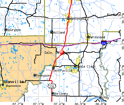
Dale, Indiana
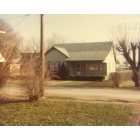
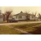
Submit your own pictures of this town and show them to the world
- OSM Map
- General Map
- Google Map
- MSN Map
Population change since 2000: -2.4%
 |
| Males: 720 | |
| Females: 810 |
| Median resident age: | 35.0 years |
| Indiana median age: | 38.2 years |
Zip codes: 47523.
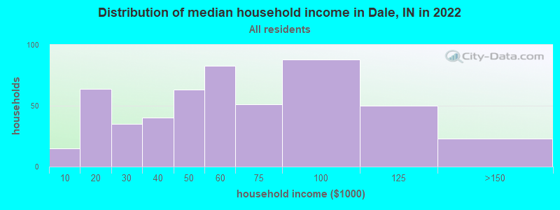
| Dale: | $52,292 |
| IN: | $66,785 |
Estimated per capita income in 2022: $22,373 (it was $16,163 in 2000)
Dale town income, earnings, and wages data
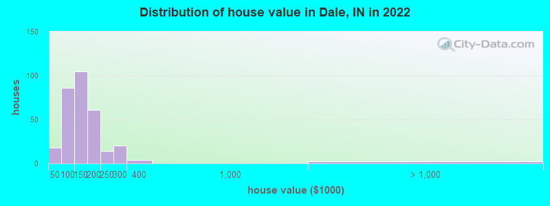
Estimated median house or condo value in 2022: $129,358 (it was $68,800 in 2000)
| Dale: | $129,358 |
| IN: | $208,700 |
Mean prices in 2022: all housing units: $141,107; detached houses: $162,467; mobile homes: $24,247
Median gross rent in 2022: $767.
(5.1% for White Non-Hispanic residents, 12.3% for Hispanic or Latino residents)
Detailed information about poverty and poor residents in Dale, IN
Compare current foreclosures near Dale, IN:
| Photo | Address | Area | Beds / Baths | Price | Details |
|---|---|---|---|---|---|

|
#1
E State Road 62
Dale, IN 47523
|
1,736 sq. feet
|
1 baths 3 beds |
show details | |

|
#2
S Gaines St
Dale, IN 47523
|
1,620 sq. feet
|
2 baths 3 beds |
show details | |

|
#3
N County Road 700 E
Dale, IN 47523
|
- sq. feet
|
- baths - beds |
show details | |

|
#4
Yellowbanks Trl Lot 75n
Dale, IN 47523
|
- sq. feet
|
- baths - beds |
show details | |

|
#5
Sunrise Dr
Dale, IN 47523
|
- sq. feet
|
- baths - beds |
show details | |

|
#6
N Sycamore St
Huntingburg, IN 47542
|
1,813 sq. feet
|
3 baths 4 beds |
show details | |

|
#7
Plymouth St
Jasper, IN 47546
|
1,708 sq. feet
|
1 baths 2 beds |
show details | |

|
#8
N Truman Rd
Jasper, IN 47546
|
1,768 sq. feet
|
1 baths 3 beds |
show details | |

|
#9
Rose Ln
Grandview, IN 47615
|
1,404 sq. feet
|
2 baths 3 beds |
show details | |

|
#10
Vine St
Jasper, IN 47546
|
1,316 sq. feet
|
1 baths 2 beds |
show details |
| Photo | Address | Area | Beds / Baths | Price | Details |
|---|---|---|---|---|---|

|
#11
Franklin St
Jasper, IN 47546
|
1,536 sq. feet
|
1 baths 4 beds |
show details | |

|
#12
Newton St
Jasper, IN 47546
|
1,920 sq. feet
|
1 baths 4 beds |
show details | |

|
#13
S Potker St
Stendal, IN 47585
|
1,410 sq. feet
|
1 baths 2 beds |
show details | |

|
#14
Meadowlane Dr
Lewisport, KY 42351
|
1,228 sq. feet
|
1 baths 3 beds |
show details | |

|
#15
W 10th St
Jasper, IN 47546
|
1,440 sq. feet
|
1 baths 2 beds |
show details | |

|
#16
River Rd
Lewisport, KY 42351
|
1,320 sq. feet
|
2 baths 4 beds |
show details | |

|
#17
W State Road 56
Jasper, IN 47546
|
1,716 sq. feet
|
2 baths 3 beds |
show details | |

|
#18
S Augusta Vigo St
Winslow, IN 47598
|
1,120 sq. feet
|
2 baths 2 beds |
show details | |

|
#19
2nd St
Grandview, IN 47615
|
925 sq. feet
|
1 baths 3 beds |
show details | |

|
#20
Oakmount Ct
Jasper, IN 47546
|
1,092 sq. feet
|
1 baths 3 beds |
show details |
| Photo | Address | Area | Beds / Baths | Price | Details |
|---|---|---|---|---|---|

|
#21
Pell St
Lewisport, KY 42351
|
864 sq. feet
|
1 baths 3 beds |
show details | |

|
#22
S State Road 145
Birdseye, IN 47513
|
1,050 sq. feet
|
1 baths 1 beds |
show details | |

|
#23
Candy Rd
Saint Meinrad, IN 47577
|
1,685 sq. feet
|
1 baths 2 beds |
show details | |

|
#24
E 2nd St
Lynnville, IN 47619
|
896 sq. feet
|
1 baths 2 beds |
show details | |

|
#25
S Balthazar Dr
Santa Claus, IN 47579
|
1,853 sq. feet
|
1 baths 3 beds |
show details | |

|
#26
E 7th St
Huntingburg, IN 47542
|
1,724 sq. feet
|
1 baths 2 beds |
show details | |

|
#27
E 1st Ave
Huntingburg, IN 47542
|
806 sq. feet
|
1 baths 2 beds |
show details | |

|
#28
Huffman Rd
Bristow, IN 47515
|
2,240 sq. feet
|
1 baths - beds |
show details | |

|
#29
Nancy Ave
Lewisport, KY 42351
|
- sq. feet
|
- baths - beds |
show details | |

|
#30
Alcoa Rd
Tell City, IN 47586
|
- sq. feet
|
- baths - beds |
show details |
| Photo | Address | Area | Beds / Baths | Price | Details |
|---|---|---|---|---|---|

|
#31
E County Road 250 S
Velpen, IN 47590
|
- sq. feet
|
- baths - beds |
show details | |

|
#32
5th St
Lewisport, KY 42351
|
- sq. feet
|
- baths - beds |
show details | |

|
#33
9th St
Grandview, IN 47615
|
- sq. feet
|
- baths - beds |
show details | |

|
#34
Macarthur St
Jasper, IN 47546
|
- sq. feet
|
- baths - beds |
show details | |

|
#35
Main St # 201
Jasper, IN 47546
|
- sq. feet
|
- baths - beds |
show details | |

|
#36
Circassian St
Gentryville, IN 47537
|
- sq. feet
|
- baths - beds |
show details | |

|
#37
W State Road 56
Jasper, IN 47546
|
- sq. feet
|
- baths - beds |
show details | |

|
#38
E 16th St
Jasper, IN 47546
|
- sq. feet
|
- baths - beds |
show details | |

|
#39
E State Road 62
Saint Meinrad, IN 47577
|
- sq. feet
|
- baths - beds |
show details | |

|
#40
W 14th St Apt 3
Jasper, IN 47546
|
- sq. feet
|
- baths - beds |
show details |
| Photo | Address | Area | Beds / Baths | Price | Details |
|---|---|---|---|---|---|

|
#41
N State Road 545
Saint Meinrad, IN 47577
|
- sq. feet
|
- baths - beds |
show details | |

|
#42
W Iowa St
Holland, IN 47541
|
- sq. feet
|
- baths - beds |
show details | |

|
#43
Park Dr N
Gentryville, IN 47537
|
- sq. feet
|
- baths - beds |
show details | |

|
#44
W 1025 S
Holland, IN 47541
|
- sq. feet
|
- baths - beds |
show details | |

|
#45
W Prancer Dr N
Santa Claus, IN 47579
|
- sq. feet
|
- baths - beds |
show details | |

|
#46
E 5th St
Huntingburg, IN 47542
|
- sq. feet
|
- baths - beds |
show details | |

|
#47
E 19th St Apt 8
Huntingburg, IN 47542
|
- sq. feet
|
- baths - beds |
show details | |

|
#48
Medical Arts Dr Apt 1b
Huntingburg, IN 47542
|
- sq. feet
|
- baths - beds |
show details | |

|
#49
Clay St
Huntingburg, IN 47542
|
- sq. feet
|
- baths - beds |
show details | |

|
Check over 1 million property listings on Foreclosure.com!
|
browse all offers | |||


- 1,02171.1%White alone
- 38126.5%Hispanic
- 392.7%Two or more races
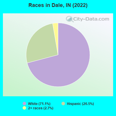
Races in Dale detailed stats: ancestries, foreign born residents, place of birth
 Recent articles from our blog. Our writers, many of them Ph.D. graduates or candidates, create easy-to-read articles on a wide variety of topics.

 | Comparing Indianapolis and Tampa (FL) (56 replies) |
| Salem, Indiana (13 replies) |
| Indianapolis more like Minneapolis or Louisville (362 replies) |
| Where do Indy people vacation? (16 replies) |
| Dale Indiana Megamaze (6 replies) |
| Where to go recreational boating? (23 replies) |
Latest news from Dale, IN collected exclusively by city-data.com from local newspapers, TV, and radio stations
Ancestries: German (40.1%), English (20.6%), American (4.8%), Irish (1.8%), Scotch-Irish (1.2%).
Current Local Time: CST time zone
Elevation: 470 feet
Land area: 1.53 square miles.
Population density: 1,001 people per square mile (low).
174 residents are foreign born (11.1% Latin America).
| This town: | 12.1% |
| Indiana: | 5.6% |
Median real estate property taxes paid for housing units with mortgages in 2022: $894 (0.6%)
Median real estate property taxes paid for housing units with no mortgage in 2022: $795 (0.7%)
Nearest city with pop. 50,000+: Owensboro, KY  (29.3 miles , pop. 54,067).
Nearest city with pop. 200,000+: Louisville, KY (67.5 miles , pop. 256,231).
Nearest city with pop. 1,000,000+: Chicago, IL (256.6 miles , pop. 2,896,016).
Nearest cities:
), ), ), ), )Latitude: 38.17 N, Longitude: 86.99 W
Area code: 812

Dale tourist attractions:
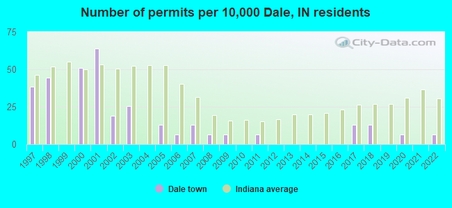
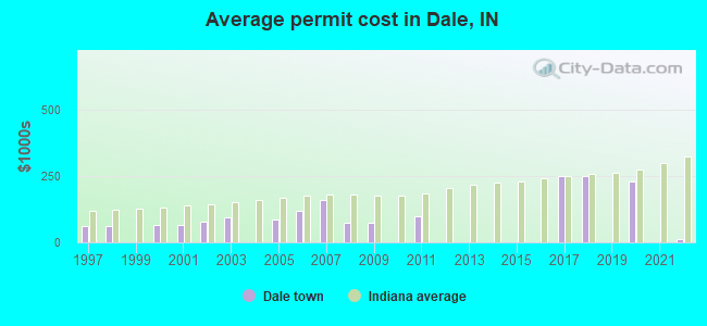
Single-family new house construction building permits:
- 2022: 1 building, cost: $12,500
- 2020: 1 building, cost: $230,000
- 2018: 2 buildings, average cost: $250,000
- 2017: 2 buildings, average cost: $250,000
- 2011: 1 building, cost: $100,000
- 2009: 1 building, cost: $75,000
- 2008: 1 building, cost: $75,000
- 2007: 2 buildings, average cost: $160,000
- 2006: 1 building, cost: $120,000
- 2005: 2 buildings, average cost: $87,500
- 2003: 4 buildings, average cost: $94,400
- 2002: 3 buildings, average cost: $78,300
- 2001: 10 buildings, average cost: $63,700
- 2000: 8 buildings, average cost: $63,800
- 1998: 7 buildings, average cost: $61,700
- 1997: 6 buildings, average cost: $61,700
| Here: | 2.8% |
| Indiana: | 2.8% |
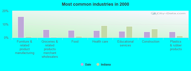
- Furniture & related product manufacturing (15.7%)
- Groceries & related products merchant wholesalers (5.9%)
- Food (5.4%)
- Health care (5.3%)
- Educational services (4.7%)
- Construction (4.5%)
- Plastics & rubber products (4.5%)
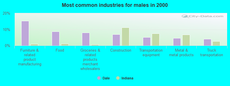
- Furniture & related product manufacturing (15.1%)
- Food (8.7%)
- Groceries & related products merchant wholesalers (7.9%)
- Construction (7.0%)
- Transportation equipment (5.0%)
- Metal & metal products (4.6%)
- Truck transportation (4.1%)
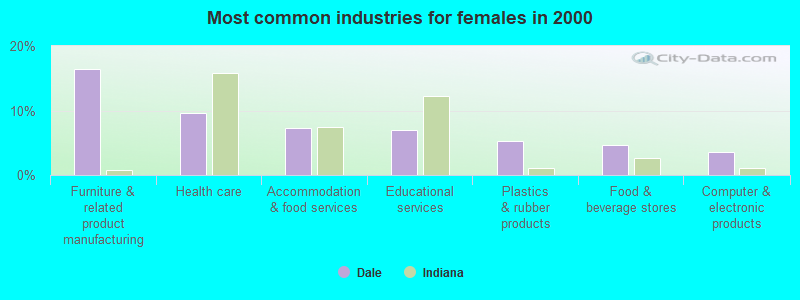
- Furniture & related product manufacturing (16.4%)
- Health care (9.6%)
- Accommodation & food services (7.3%)
- Educational services (7.0%)
- Plastics & rubber products (5.3%)
- Food & beverage stores (4.7%)
- Computer & electronic products (3.5%)
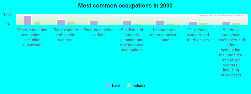
- Other production occupations, including supervisors (11.1%)
- Metal workers and plastic workers (6.3%)
- Food processing workers (4.9%)
- Building and grounds cleaning and maintenance occupations (4.7%)
- Laborers and material movers, hand (4.6%)
- Driver/sales workers and truck drivers (4.0%)
- Electrical equipment mechanics and other installation, maintenance, and repair workers, including supervisors (3.7%)
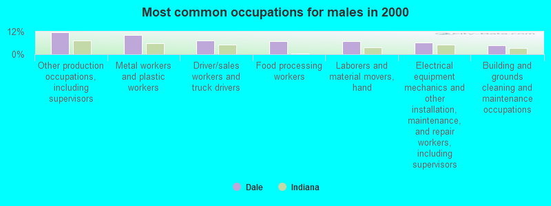
- Other production occupations, including supervisors (11.5%)
- Metal workers and plastic workers (10.1%)
- Driver/sales workers and truck drivers (7.2%)
- Food processing workers (7.0%)
- Laborers and material movers, hand (6.7%)
- Electrical equipment mechanics and other installation, maintenance, and repair workers, including supervisors (6.2%)
- Building and grounds cleaning and maintenance occupations (4.8%)
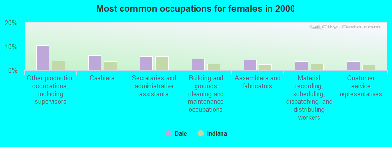
- Other production occupations, including supervisors (10.5%)
- Cashiers (6.1%)
- Secretaries and administrative assistants (5.8%)
- Building and grounds cleaning and maintenance occupations (4.7%)
- Assemblers and fabricators (4.4%)
- Material recording, scheduling, dispatching, and distributing workers (3.8%)
- Customer service representatives (3.8%)
Average climate in Dale, Indiana
Based on data reported by over 4,000 weather stations


(lower is better)
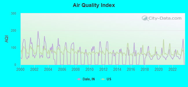
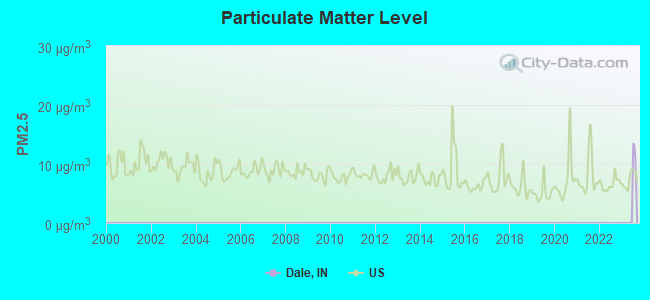
Air Quality Index (AQI) level in 2023 was 77.0. This is about average.
| City: | 77.0 |
| U.S.: | 72.6 |
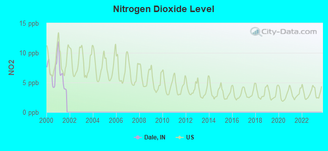
Nitrogen Dioxide (NO2) [ppb] level in 2001 was 6.15. This is worse than average. Closest monitor was 13.2 miles away from the city center.
| City: | 6.15 |
| U.S.: | 5.11 |
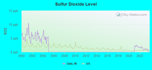
Sulfur Dioxide (SO2) [ppb] level in 2023 was 0.899. This is significantly better than average. Closest monitor was 15.8 miles away from the city center.
| City: | 0.899 |
| U.S.: | 1.515 |
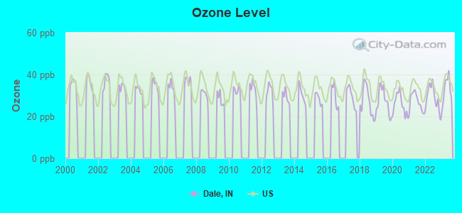
Ozone [ppb] level in 2023 was 32.7. This is about average. Closest monitor was 17.7 miles away from the city center.
| City: | 32.7 |
| U.S.: | 33.3 |
Tornado activity:
Dale-area historical tornado activity is slightly below Indiana state average. It is 57% greater than the overall U.S. average.
On 4/3/1974, a category F5 (max. wind speeds 261-318 mph) tornado 14.6 miles away from the Dale town center killed 6 people and injured 86 people and caused between $50,000,000 and $500,000,000 in damages.
On 4/3/1974, a category F5 tornado 39.3 miles away from the town center killed 31 people and injured 270 people and caused between $500,000 and $5,000,000 in damages.
Earthquake activity:
Dale-area historical earthquake activity is significantly above Indiana state average. It is 170% greater than the overall U.S. average.On 4/18/2008 at 09:36:59, a magnitude 5.4 (5.1 MB, 4.8 MS, 5.4 MW, 5.2 MW, Class: Moderate, Intensity: VI - VII) earthquake occurred 52.5 miles away from Dale center
On 4/18/2008 at 09:36:59, a magnitude 5.2 (5.2 MW, Depth: 8.9 mi) earthquake occurred 52.5 miles away from the city center
On 6/10/1987 at 23:48:54, a magnitude 5.1 (4.9 MB, 4.4 MS, 4.6 MS, 5.1 LG) earthquake occurred 66.3 miles away from the city center
On 6/18/2002 at 17:37:15, a magnitude 5.0 (4.3 MB, 4.6 MW, 5.0 LG) earthquake occurred 44.9 miles away from Dale center
On 4/18/2008 at 15:14:16, a magnitude 4.8 (4.5 MB, 4.8 MW, 4.6 MW, Class: Light, Intensity: IV - V) earthquake occurred 51.2 miles away from the city center
On 4/18/2008 at 15:14:17, a magnitude 4.7 (4.7 MW, Depth: 9.6 mi) earthquake occurred 51.9 miles away from Dale center
Magnitude types: regional Lg-wave magnitude (LG), body-wave magnitude (MB), surface-wave magnitude (MS), moment magnitude (MW)
Natural disasters:
The number of natural disasters in Spencer County (13) is near the US average (15).Major Disasters (Presidential) Declared: 9
Emergencies Declared: 2
Causes of natural disasters: Floods: 8, Storms: 7, Tornadoes: 3, Blizzard: 1, Hurricane: 1, Snow: 1, Wind: 1, Winter Storm: 1, Other: 1 (Note: some incidents may be assigned to more than one category).

Hospitals and medical centers in Dale:
Colleges/universities with over 2000 students nearest to Dale:
- Owensboro Community and Technical College (about 32 miles; Owensboro, KY; Full-time enrollment: 2,754)
- University of Evansville (about 33 miles; Evansville, IN; FT enrollment: 2,688)
- University of Southern Indiana (about 41 miles; Evansville, IN; FT enrollment: 9,532)
- Vincennes University (about 47 miles; Vincennes, IN; FT enrollment: 9,876)
- Wabash Valley College (about 47 miles; Mount Carmel, IL; FT enrollment: 2,142)
- Madisonville Community College (about 63 miles; Madisonville, KY; FT enrollment: 2,082)
- Indiana University-Southeast (about 65 miles; New Albany, IN; FT enrollment: 5,050)
Public elementary/middle school in Dale:
- DAVID TURNHAM EDL CTR (Students: 263, Location: DUNN & LOCUST STS, Grades: PK-6)
Points of interest:
Notable location: Carter Fire District (A). Display/hide its location on the map
Church in Dale: Saint Josephs Church (A). Display/hide its location on the map
Cemetery: Dale Cemetery (1). Display/hide its location on the map
Tourist attraction: Dr Ted's Musical Marvels (Museums; North Highway 231 & I64).
Hotels: Motel 6 (1334 North Washington Street), Stone's Motel (Highway 231 South), 231 Ambest Plaza Truck Stop (21595 North US Highway 231), Motel 6 Dale (20840 N Highway 231).
Birthplace of: Florence Henderson - Female singer, Roger Kaiser - Basketball player-coach.
Drinking water stations with addresses in Dale and their reported violations in the past:
DALE WATER WORKS (Population served: 1,822, Purch surface water):Past health violations:Past monitoring violations:
- MCL, Monthly (TCR) - In SEP-2009, Contaminant: Coliform. Follow-up actions: St Boil Water Order (SEP-25-2009), St Violation/Reminder Notice (SEP-25-2009), St Public Notif requested (SEP-25-2009), St Public Notif received (SEP-28-2009), St Compliance achieved (MAY-17-2010)
- MCL, Monthly (TCR) - In MAY-2007, Contaminant: Coliform. Follow-up actions: St Public Notif requested (MAY-29-2007), St Violation/Reminder Notice (MAY-29-2007), St Boil Water Order (MAY-29-2007), St Compliance achieved (MAY-17-2010)
- Follow-up Or Routine LCR Tap M/R - In OCT-01-2012, Contaminant: Lead and Copper Rule. Follow-up actions: St Public Notif requested (DEC-18-2012), St Violation/Reminder Notice (DEC-18-2012), St Public Notif received (JUL-01-2013), St Compliance achieved (NOV-21-2013)
| This town: | 2.5 people |
| Indiana: | 2.5 people |
| This town: | 67.3% |
| Whole state: | 66.9% |
| This town: | 5.3% |
| Whole state: | 6.9% |
Likely homosexual households (counted as self-reported same-sex unmarried-partner households)
- Lesbian couples: 0.3% of all households
- Gay men: 0.5% of all households
70 people in nursing homes in 2000
Banks with branches in Dale (2011 data):
- Freedom Bank: Dale Branch at 10 East Medcalf Street, branch established on 2000/02/22. Info updated 2006/11/03: Bank assets: $310.5 mil, Deposits: $273.2 mil, headquarters in Huntingburg, IN, positive income, Commercial Lending Specialization, 4 total offices, Holding Company: Freedom Bancorp
- Spencer County Bank: Dale Branch at 10 North Washington Street, branch established on 1987/12/04. Info updated 2006/11/03: Bank assets: $106.4 mil, Deposits: $95.2 mil, headquarters in Santa Claus, IN, positive income, Mortgage Lending Specialization, 5 total offices
For population 15 years and over in Dale:
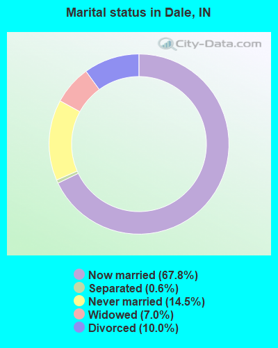
- Never married: 14.5%
- Now married: 67.8%
- Separated: 0.6%
- Widowed: 7.0%
- Divorced: 10.0%
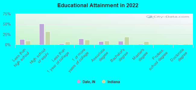
For population 25 years and over in Dale:
- High school or higher: 86.0%
- Bachelor's degree or higher: 10.2%
- Graduate or professional degree: 1.8%
- Unemployed: 4.4%
- Mean travel time to work (commute): 24.5 minutes
| Here: | 11.4 |
| Indiana average: | 11.3 |

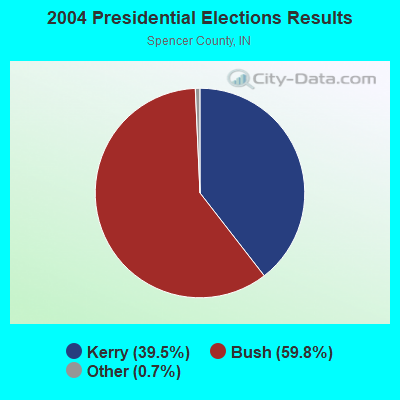
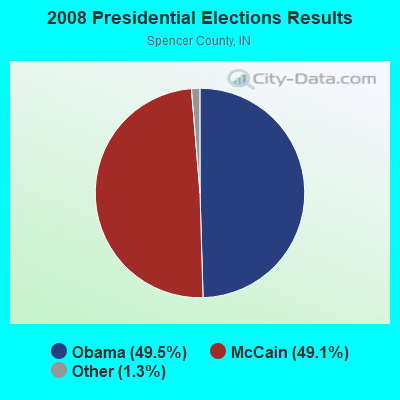
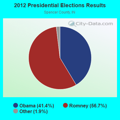
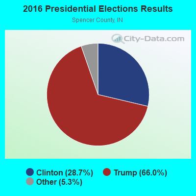
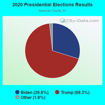
Graphs represent county-level data. Detailed 2008 Election Results
Religion statistics for Dale, IN (based on Spencer County data)
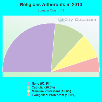
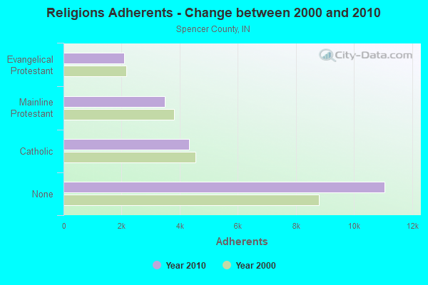
| Religion | Adherents | Congregations |
|---|---|---|
| Catholic | 4,309 | 8 |
| Mainline Protestant | 3,486 | 22 |
| Evangelical Protestant | 2,098 | 21 |
| Other | - | 1 |
| None | 11,059 | - |
Food Environment Statistics:
| This county: | 1.97 / 10,000 pop. |
| Indiana: | 1.73 / 10,000 pop. |
| Spencer County: | 0.49 / 10,000 pop. |
| State: | 0.50 / 10,000 pop. |
| Spencer County: | 6.41 / 10,000 pop. |
| Indiana: | 3.57 / 10,000 pop. |
| Spencer County: | 4.44 / 10,000 pop. |
| Indiana: | 6.78 / 10,000 pop. |
| Spencer County: | 9.5% |
| State: | 9.2% |
| Here: | 29.0% |
| State: | 29.0% |
| Here: | 16.5% |
| Indiana: | 14.3% |
Health and Nutrition:
| This city: | 46.1% |
| Indiana: | 49.3% |
| Dale: | 40.7% |
| Indiana: | 46.2% |
| Dale: | 28.8 |
| Indiana: | 28.7 |
| Here: | 21.6% |
| Indiana: | 21.3% |
| Dale: | 12.7% |
| State: | 10.6% |
| Dale: | 6.8 |
| Indiana: | 6.8 |
| This city: | 34.3% |
| Indiana: | 33.9% |
| Dale: | 52.1% |
| Indiana: | 56.1% |
| This city: | 76.0% |
| Indiana: | 78.7% |
More about Health and Nutrition of Dale, IN Residents
| Local government employment and payroll (March 2022) | |||||
| Function | Full-time employees | Monthly full-time payroll | Average yearly full-time wage | Part-time employees | Monthly part-time payroll |
|---|---|---|---|---|---|
| Financial Administration | 2 | $7,071 | $42,426 | 1 | $1,239 |
| Police Protection - Officers | 2 | $7,238 | $43,428 | 0 | $0 |
| Parks and Recreation | 1 | $3,358 | $40,296 | 2 | $38 |
| Sewerage | 1 | $4,023 | $48,276 | 0 | $0 |
| Water Supply | 1 | $3,418 | $41,016 | 0 | $0 |
| Streets and Highways | 1 | $3,263 | $39,156 | 1 | $1,218 |
| Other Government Administration | 0 | $0 | 6 | $404 | |
| Totals for Government | 8 | $28,372 | $42,558 | 10 | $2,899 |
Dale government finances - Expenditure in 2017 (per resident):
- Construction - Water Utilities: $2,972,000 ($1942.48)
- Current Operations - Water Utilities: $337,000 ($220.26)
Central Staff Services: $289,000 ($188.89)
Sewerage: $257,000 ($167.97)
Parks and Recreation: $125,000 ($81.70)
Regular Highways: $81,000 ($52.94)
Police Protection: $2,000 ($1.31)
- General - Interest on Debt: $103,000 ($67.32)
- Other Capital Outlay - Sewerage: $29,000 ($18.95)
Regular Highways: $5,000 ($3.27)
Water Utilities: $4,000 ($2.61)
Dale government finances - Revenue in 2017 (per resident):
- Charges - Sewerage: $825,000 ($539.22)
Parks and Recreation: $35,000 ($22.88)
- Local Intergovernmental - Highways: $7,000 ($4.58)
- Miscellaneous - Donations From Private Sources: $13,000 ($8.50)
Interest Earnings: $4,000 ($2.61)
Sale of Property: $3,000 ($1.96)
General Revenue - Other: $1,000 ($0.65)
- Revenue - Water Utilities: $3,505,000 ($2290.85)
- State Intergovernmental - Other: $55,000 ($35.95)
Highways: $55,000 ($35.95)
General Local Government Support: $21,000 ($13.73)
- Tax - Property: $304,000 ($198.69)
Other License: $6,000 ($3.92)
Dale government finances - Debt in 2017 (per resident):
- Long Term Debt - Beginning Outstanding - Unspecified Public Purpose: $2,590,000 ($1692.81)
Outstanding Unspecified Public Purpose: $2,590,000 ($1692.81)
Dale government finances - Cash and Securities in 2017 (per resident):
- Bond Funds - Cash and Securities: $221,000 ($144.44)
- Other Funds - Cash and Securities: $2,454,000 ($1603.92)
- Sinking Funds - Cash and Securities: $323,000 ($211.11)
| Businesses in Dale, IN | ||||
| Name | Count | Name | Count | |
|---|---|---|---|---|
| Best Western | 1 | Motel 6 | 1 | |
| Dennys | 1 | Subway | 1 | |
| Ford | 1 | U-Haul | 1 | |
| H&R Block | 1 | |||
Strongest AM radio stations in Dale:
- WHAS (840 AM; 50 kW; LOUISVILLE, KY; Owner: CLEAR CHANNEL BROADCASTING LICENSES, INC.)
- WITZ (990 AM; 1 kW; JASPER, IN; Owner: JASPER ON THE AIR, INC.)
- WGBF (1280 AM; 5 kW; EVANSVILLE, IN; Owner: CLEAR CHANNEL BROADCASTING LICENSES, INC.)
- WKCM (1160 AM; 2 kW; HAWESVILLE, KY; Owner: HANCOCK COMMUNICATIONS, INC.)
- WVJS (1420 AM; 5 kW; OWENSBORO, KY; Owner: TSB III, LLC)
- WVHI (1330 AM; 5 kW; EVANSVILLE, IN)
- WSM (650 AM; 50 kW; NASHVILLE, TN; Owner: GAYLORD ENTERTAINMENT COMPANY)
- WIBC (1070 AM; 50 kW; INDIANAPOLIS, IN; Owner: EMMIS RADIO LICENSE CORPORATION)
- WLW (700 AM; 50 kW; CINCINNATI, OH; Owner: JACOR BROADCASTING CORPORATION)
- WKJK (1080 AM; 10 kW; LOUISVILLE, KY; Owner: CLEAR CHANNEL BROADCASTING LICENSES, INC.)
- WKDA (1200 AM; 50 kW; NASHVILLE, TN; Owner: RADIO NASHVILLE, INC.)
- WAMB (1160 AM; 50 kW; DONELSON, TN; Owner: GREAT SOUTHERN BROADCASTING COMPANY, INC.)
- WNQM (1300 AM; 50 kW; NASHVILLE, TN; Owner: WNQM. INC.)
Strongest FM radio stations in Dale:
- WAXL (103.3 FM; SANTA CLAUS, IN; Owner: DUBOIS COUNTY BROADCASTING, INC.)
- WGZB-FM (96.5 FM; CORYDON, IN; Owner: BLUE CHIP BROADCASTING LICENSES II, LTD.)
- WBDC (100.9 FM; HUNTINGBURG, IN; Owner: DUBOIS COUNTY BROADCASTING, INC.)
- WQKZ (98.5 FM; FERDINAND, IN; Owner: GEM COMMUNICATIONS LLP)
- WNIN-FM (88.3 FM; EVANSVILLE, IN; Owner: TRI-STATE PUBLIC TELEPLEX, INC.)
- WITZ-FM (104.7 FM; JASPER, IN; Owner: JASPER ON THE AIR, INC.)
- WYXY (107.1 FM; BOONVILLE, IN; Owner: BOONVILLE BROADCASTING CO., INC.)
- WSTO (96.1 FM; OWENSBORO, KY; Owner: TSB III, LLC)
- WKDQ (99.5 FM; HENDERSON, KY; Owner: REGENT BROADCASTING OF EVANSVILLE/OWENSBORO, INC.)
- WBKR (92.5 FM; OWENSBORO, KY; Owner: REGENT BROADCASTING OF EVANSVILLE/OWENSBORO, INC.)
- W209AY (89.7 FM; JASPER, IN; Owner: BIBLE BROADCASTING NETWORK, INC.)
- WJPS-FM (93.5 FM; CHANDLER, IN; Owner: SOUTH CENTRAL COMMUNICATIONS CORP.)
- WBGW (101.5 FM; FORT BRANCH, IN; Owner: MUSIC MINISTRIES, INC.)
- WTCJ-FM (105.7 FM; TELL CITY, IN; Owner: HANCOCK COMMUNICATIONS, INC.)
- WBHW (88.7 FM; LOOGOOTEE, IN; Owner: MUSIC MINISTRIES, INC.)
TV broadcast stations around Dale:
- WNIN (Channel 9; EVANSVILLE, IN; Owner: TRI-STATE PUBLIC TELEPLEX, INC.)
- WTVW (Channel 7; EVANSVILLE, IN; Owner: QUORUM OF INDIANA LICENSE, LLC)
- WJTS-LP (Channel 27; JASPER, IN; Owner: PAUL E. KNIES)
- K55HL (Channel 55; CAPE GIRARDEAU, MO; Owner: MS COMMUNICATIONS, LLC)
- WFIE (Channel 14; EVANSVILLE, IN; Owner: LIBCO, INC.)
- WEVV (Channel 44; EVANSVILLE, IN; Owner: COMCORP OF INDIANA LICENSE CORP.)
- WEHT (Channel 25; EVANSVILLE, IN; Owner: GILMORE BROADCASTING CORPORATION)
- WKOH (Channel 31; OWENSBORO, KY; Owner: KENTUCKY AUTHORITY FOR EDUCATIONAL TV)
- Dale, Indiana
- Fatal accident count18
- Vehicles involved in fatal accidents30
- Fatal accidents involving drunk persons:1
- Fatalities23
- Persons involved in fatal accidents51
- Pedestrians involved in fatal accidents2
- Indiana average
- Fatal accident count10834
- Vehicles involved in fatal accidents17132
- Fatal accidents involving drunk persons2745
- Fatalities11925
- Persons involved in fatal accidents25391
- Pedestrians involved in fatal accidents1454
- National Bridge Inventory (NBI) Statistics
- 39Number of bridges
- 341ft / 104mTotal length
- $474,000Total costs
- 170,927Total average daily traffic
- 28,352Total average daily truck traffic
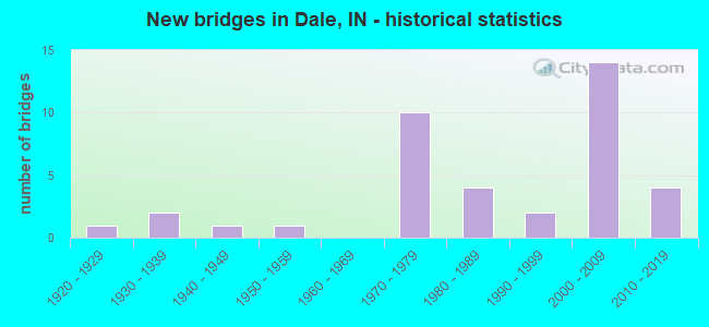
- New bridges - historical statistics
- 11920-1929
- 21930-1939
- 11940-1949
- 11950-1959
- 101970-1979
- 41980-1989
- 21990-1999
- 142000-2009
- 42010-2019
FCC Registered Cell Phone Towers:
1 (See the full list of FCC Registered Cell Phone Towers in Dale)FCC Registered Antenna Towers:
46 (See the full list of FCC Registered Antenna Towers)FCC Registered Private Land Mobile Towers:
1- Dale In Aei Near Rr Mp 036.63 Eb (Lat: 38.163111 Lon: -86.975806), Type: Pole, Structure height: 3 m, Call Sign: WPUA471,
Assigned Frequencies: 910.000 MHz, 911.500 MHz, 918.500 MHz, Grant Date: 12/23/2021, Expiration Date: 01/23/2032, Certifier: Jerry R Celio, Registrant: Norfolk Southern Railway Company, 1200 Peachtree Street, Ne, Box 123, Atlanta, GA 30309, Phone: (404) 583-1233, Fax: (404) 582-6209, Email:
FCC Registered Broadcast Land Mobile Towers:
2- 2 Blks E 62 2 Blks S Jct 62 & 45 (Lat: 38.167000 Lon: -86.987500), Structure height: 61 m, Call Sign: KFK676, Licensee ID: L00007694,
Assigned Frequencies: 47.2800 MHz, 47.3600 MHz, Grant Date: 01/13/2004, Expiration Date: 03/16/2014, Cancellation Date: 08/06/2008, Registrant: State Of Indiana, 100 N Senate Ave Rm N925, Indianapolis, IN 46204, Phone: (317) 232-5513
- 1/4 Mi E Int Hwys 68 & 161 (Lat: 38.206722 Lon: -87.128056), Call Sign: KNEU285, Licensee ID: L00025040,
Assigned Frequencies: 152.945 MHz, Grant Date: 01/30/1998, Expiration Date: 02/05/2003, Cancellation Date: 03/29/2002, Registrant: Ray Lindsey, Rr 2, Dale, IN 47523
FCC Registered Microwave Towers:
4- Thermwood Dale, Lat: 38.154111 Lon: -86.993000, Type: Tank, Structure height: 42 m, Call Sign: WQJG332,
Assigned Frequencies: 3672.50 MHz, Grant Date: 06/14/2018, Expiration Date: 10/17/2020, Cancellation Date: 12/19/2020, Certifier: James M Dauby, Registrant: Perry-Spencer Communications, Inc., 11877 E State Rd 62, St. Meinrad, IN 47577, Phone: (812) 357-2123, Fax: (812) 357-2211, Email:
- EVN0601, 7511 Miller Rd (Lat: 38.140556 Lon: -87.040500), Type: Mtower, Structure height: 91.4 m, Overall height: 97.2 m, Call Sign: WQOW762,
Assigned Frequencies: 11265.0 MHz, 11425.0 MHz, 11465.0 MHz, 11385.0 MHz, 11345.0 MHz, 11545.0 MHz, 11345.0 MHz, 11465.0 MHz, 11345.0 MHz, 11465.0 MHz... (+8 more), Grant Date: 04/11/2022, Expiration Date: 02/17/2032, Certifier: Scott E Beer, Registrant: Morgan, Lewis & Bockius, 1111 Pennsylvania Ave. Nw, Washington, DC 20004, Phone: (202) 739-3000, Email:
- EVN0603, 7155 Marshall Road (Lat: 38.198528 Lon: -87.106194), Type: Tower, Structure height: 54.9 m, Call Sign: WQOW763,
Assigned Frequencies: 10775.0 MHz, 10895.0 MHz, Grant Date: 04/11/2022, Expiration Date: 02/17/2032, Certifier: Scott E Beer, Registrant: Morgan, Lewis & Bockius, 1111 Pennsylvania Ave. Nw, Washington, DC 20004, Phone: (202) 739-3000, Email:
- LINCOLN CITY, 7511 Miller Rd (Lat: 38.140556 Lon: -87.040500), Type: Ltower, Structure height: 91.4 m, Overall height: 97.2 m, Call Sign: WQVU895,
Assigned Frequencies: 6034.15 MHz, 6093.45 MHz, Grant Date: 05/15/2015, Expiration Date: 05/15/2025, Cancellation Date: 04/09/2021, Certifier: Gregory M Romano, Registrant: Verizon, 1300 I St Nw - Suite 500 East, Washington, DC 20005, Phone: (202) 515-2453, Email:
FCC Registered Paging Towers:
1- 1400 M W Of Rte 231 (Lat: 38.199472 Lon: -86.991917), Overall height: 88 m, Call Sign: KNKC796,
Assigned Frequencies: 152.540 MHz, Grant Date: 05/11/1999, Expiration Date: 04/01/2009, Cancellation Date: 03/09/2005, Registrant: Keller & Heckman LLP, 1001 G Street Nw, Washington, DC 20001, Phone: (202) 434-4100
FCC Registered Amateur Radio Licenses:
10 (See the full list of FCC Registered Amateur Radio Licenses in Dale)2002 - 2018 National Fire Incident Reporting System (NFIRS) incidents
- Fire incident types reported to NFIRS in Dale, IN
- 9545.9%Structure Fires
- 6531.4%Outside Fires
- 3818.4%Mobile Property/Vehicle Fires
- 94.3%Other
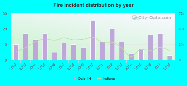 According to the data from the years 2002 - 2018 the average number of fire incidents per year is 12. The highest number of reported fires - 25 took place in 2010, and the least - 3 in 2018. The data has a declining trend.
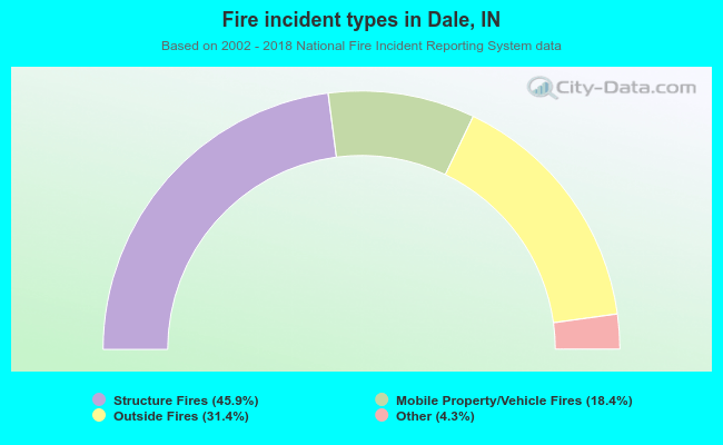 When looking into fire subcategories, the most reports belonged to: Structure Fires (45.9%), and Outside Fires (31.4%).
Fire-safe hotels and motels in Dale, Indiana:
- Stone's Motel, Hwy 231 S, Dale, Indiana 47523 , Phone: (812) 937-4448
- Motel 6, 1334 N Washington, Dale, Indiana 47523 , Phone: (812) 937-2294, Fax: (812) 937-2495
| Most common first names in Dale, IN among deceased individuals | ||
| Name | Count | Lived (average) |
|---|---|---|
| William | 37 | 76.4 years |
| Mary | 29 | 79.7 years |
| John | 23 | 77.8 years |
| Robert | 19 | 71.8 years |
| Charles | 15 | 77.9 years |
| James | 15 | 73.7 years |
| Albert | 14 | 76.1 years |
| Carl | 14 | 74.6 years |
| Clarence | 12 | 76.6 years |
| Helen | 12 | 81.5 years |
| Most common last names in Dale, IN among deceased individuals | ||
| Last name | Count | Lived (average) |
|---|---|---|
| Cooper | 13 | 70.7 years |
| Brown | 12 | 76.9 years |
| Schum | 11 | 75.5 years |
| Springston | 11 | 75.8 years |
| Gogel | 11 | 78.4 years |
| Medcalf | 11 | 79.1 years |
| Wahl | 9 | 82.7 years |
| Schaaf | 8 | 88.2 years |
| Taylor | 8 | 73.7 years |
| Kaetzel | 8 | 78.7 years |
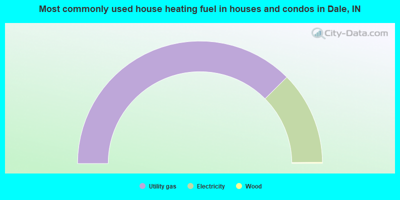
- 75.1%Utility gas
- 24.6%Electricity
- 0.3%Wood
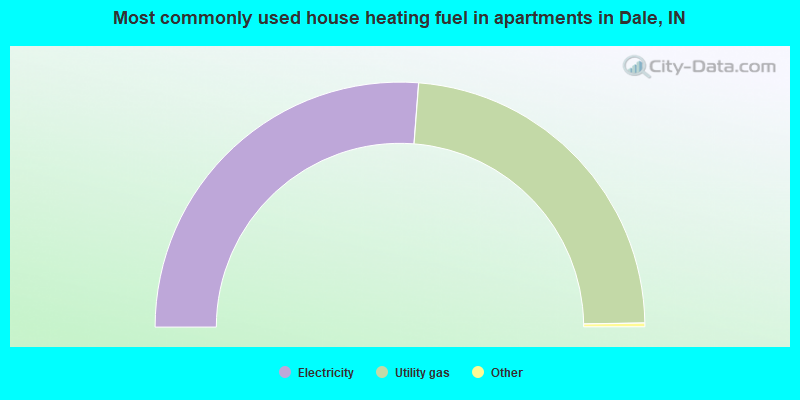
- 52.7%Electricity
- 47.3%Utility gas
Dale compared to Indiana state average:
- Median house value below state average.
- Unemployed percentage significantly below state average.
- Black race population percentage significantly below state average.
- Hispanic race population percentage significantly above state average.
- Foreign-born population percentage above state average.
- Length of stay since moving in significantly above state average.
- Institutionalized population percentage above state average.
- Number of college students below state average.
- Percentage of population with a bachelor's degree or higher below state average.

|
|
Total of 10 patent applications in 2008-2024.