Bridge Statistics for Danville, Illinois (IL)
Condition, Traffic, Stress, Structural Evaluation, Project Costs
- National Bridge Inventory (NBI) Statistics
- 109Number of bridges
- 1,342ft / 409mTotal length
- $5,187,000Total costs
- 605,945Total average daily traffic
- 128,405Total average daily truck traffic
- National Bridge Inventory (NBI) Registered Bridges for Danville
- No street view available for this location
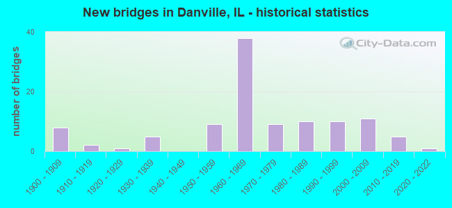
- New bridges - historical statistics
- 81900-1909
- 21910-1919
- 11920-1929
- 51930-1939
- 91950-1959
- 381960-1969
- 91970-1979
- 101980-1989
- 101990-1999
- 112000-2009
- 52010-2019
- 12020-2022

- Reconstructed bridges - Historical Statistics
- 31970-1979
- 111980-1989
- 11990-1999


- Bridge Condition - Deck
- 3.2%Excellent
- 7.9%Very good
- 15.9%Good
- 57.1%Satisfactory
- 4.8%Fair
- 7.9%Poor
- 3.2%Serious

- Bridge Condition - Superstructure
- 3.1%Excellent
- 14.1%Very good
- 23.4%Good
- 39.1%Satisfactory
- 12.5%Fair
- 6.3%Poor
- 1.6%Serious

- Bridge Condition - Substructure
- 3.1%Excellent
- 21.9%Very good
- 48.4%Good
- 12.5%Satisfactory
- 10.9%Fair
- 1.6%Poor
- 1.6%Serious

- Bridge Condition - Channel
- 23.2%Very good
- 39.3%Good
- 23.2%Satisfactory
- 14.3%Fair

- Bridge Condition - Culverts
- 8.3%Very good
- 33.3%Good
- 41.7%Satisfactory
- 16.7%Fair
Find on map >> Show street view
Structure Number: 920006, Location: W OF DANVILLE (Lat: 40.115622, Lng: -87.694794), Route carried "on" structure: Interstate 74, Year Built: 1962, Year Reconstructed: 2021, Status: Open, Structure Length: 22.87m (75.03ft), Average Daily Traffic: 10,600 (year 2021), Truck Traffic: 38%, Average Future Daily Traffic: 9,140 (year 2032), Design Load: HS 20+Mod, Features Intersected: SALT FORK VERM RIVER
Minimum Vertical Clearance: 30+ m (98+ ft), Kilometerpoint: 342.491, Lanes on structure: 2, Base Highway Network: Yes, Owner: State Highway Agency, Approaching Roadway Width: 11.9m (39.0ft), Material/Design: Steel continuous, Design/Construction: Girder and Floorbeam System, Number Of Spans In Main Unit: 7, Number Of Approach Spans: 2, Length of Maximum Span: 35.4m (116.1ft), Curb-To-Curb Width: 10.0m (32.8ft), Out-to-Out Width: 11.0m (36.1ft)
Condition: Deck: Satisfactory, Superstructure: Fair, Substructure: Good, Channel: Good, Operating Rating: 59.6 metric tons, Method Used To Determine Operating Rating: Load Factor (LF) rating reported by rating factor (RF) method using MS18 loading, Inventory Rating: 35.6 metric tons, Method Used To Determine Inventory Rating: Load Factor (LF) rating reported by rating factor (RF) method using MS18 loading, Structural Evaluation: Somewhat better than minimum adequacy, Deck Geometry: Meets minimum limits, Waterway Adequacy: Equal to present desirable criteria, Approach Roadway Alignment: Equal to present desirable criteria, Designated Inspection Frequency: Every 24 months, Critical Feature Inspection Frequency: Every 24 months, Inspection Date: July 2021, Critical Feature Inspection Date: October 2020, Deck Structure Type: Concrete Cast-file-Place, Wearing Surface/Protective System: Deck Protection: Epoxy Coated Reinforcing
Find on map >> Show street view
Structure Number: 920007, Location: W OF DANVILLE (Lat: 40.115542, Lng: -87.694642), Route carried "on" structure: Interstate 74, Year Built: 1962, Year Reconstructed: 2021, Status: Open, Structure Length: 22.87m (75.03ft), Average Daily Traffic: 10,600 (year 2021), Truck Traffic: 38%, Average Future Daily Traffic: 9,140 (year 2032), Design Load: HS 20+Mod, Features Intersected: SALT FORK VERM RIVER
Minimum Vertical Clearance: 30+ m (98+ ft), Kilometerpoint: 342.507, Lanes on structure: 2, Base Highway Network: Yes, Owner: State Highway Agency, Approaching Roadway Width: 11.9m (39.0ft), Material/Design: Steel continuous, Design/Construction: Girder and Floorbeam System, Number Of Spans In Main Unit: 7, Number Of Approach Spans: 2, Length of Maximum Span: 35.4m (116.1ft), Curb-To-Curb Width: 10.0m (32.8ft), Out-to-Out Width: 11.0m (36.1ft)
Condition: Deck: Excellent, Superstructure: Excellent, Substructure: Excellent, Channel: Good, Operating Rating: 64.5 metric tons, Method Used To Determine Operating Rating: Load and Resistance Factor Rating (LRFR) rating reported by rating factor(RF) method using HL-93 loadings, Inventory Rating: 49.6 metric tons, Method Used To Determine Inventory Rating: Load and Resistance Factor Rating (LRFR) rating reported by rating factor(RF) method using HL-93 loadings, Structural Evaluation: Superior to present desirable criteria, Deck Geometry: Meets minimum limits, Waterway Adequacy: Equal to present desirable criteria, Approach Roadway Alignment: Equal to present desirable criteria, Designated Inspection Frequency: Every 24 months, Inspection Date: January 2022, Deck Structure Type: Concrete Cast-file-Place, Wearing Surface/Protective System: Deck Protection: Epoxy Coated Reinforcing
Find on map >> Show street view
Structure Number: 920014, Location: S OF DANVILLE (Lat: 40.110700, Lng: -87.616581), Route carried "on" structure: Interstate 74, Year Built: 1964, Year Reconstructed: 1991, Status: Open, Structure Length: 17.79m (58.37ft), Average Daily Traffic: 13,600 (year 2021), Truck Traffic: 30%, Average Future Daily Traffic: 13,813 (year 2032), Design Load: HS 20+Mod, Features Intersected: VERMILION RIVER
Minimum Vertical Clearance: 30+ m (98+ ft), Kilometerpoint: 349.717, Lanes on structure: 2, Base Highway Network: Yes, Owner: State Highway Agency, Approaching Roadway Width: 11.9m (39.0ft), Skew: 3 degrees, Material/Design: Steel continuous, Design/Construction: Stringer/Multi-beam, Number Of Spans In Main Unit: 5, Number Of Approach Spans: 2, Length of Maximum Span: 38.4m (126.0ft), Curb-To-Curb Width: 12.6m (41.3ft), Out-to-Out Width: 13.5m (44.3ft)
Condition: Deck: Satisfactory, Superstructure: Good, Substructure: Good, Channel: Good, Operating Rating: 62.2 metric tons, Method Used To Determine Operating Rating: Load Factor (LF) rating reported by rating factor (RF) method using MS18 loading, Inventory Rating: 37.3 metric tons, Method Used To Determine Inventory Rating: Load Factor (LF) rating reported by rating factor (RF) method using MS18 loading, Structural Evaluation: Better than present minimum criteria, Deck Geometry: Better than present minimum criteria, Waterway Adequacy: Equal to present desirable criteria, Approach Roadway Alignment: Equal to present desirable criteria, Designated Inspection Frequency: Every 24 months, Inspection Date: April 2021, Deck Structure Type: Concrete Cast-file-Place, Wearing Surface/Protective System: Deck Protection: Epoxy Coated Reinforcing
Find on map >> Show street view
Structure Number: 920015, Location: S OF DANVILLE (Lat: 40.110792, Lng: -87.616428), Route carried "on" structure: Interstate 74, Year Built: 1964, Year Reconstructed: 1991, Status: Open, Structure Length: 17.79m (58.37ft), Average Daily Traffic: 13,600 (year 2021), Truck Traffic: 30%, Average Future Daily Traffic: 13,813 (year 2032), Design Load: HS 20+Mod, Features Intersected: VERMILION RIVER
Minimum Vertical Clearance: 30+ m (98+ ft), Kilometerpoint: 349.733, Lanes on structure: 2, Base Highway Network: Yes, Owner: State Highway Agency, Approaching Roadway Width: 11.9m (39.0ft), Skew: 3 degrees, Material/Design: Steel continuous, Design/Construction: Stringer/Multi-beam, Number Of Spans In Main Unit: 5, Number Of Approach Spans: 2, Length of Maximum Span: 38.4m (126.0ft), Curb-To-Curb Width: 12.2m (40.0ft), Out-to-Out Width: 13.2m (43.3ft)
Condition: Deck: Satisfactory, Superstructure: Good, Substructure: Good, Channel: Good, Operating Rating: 58.0 metric tons, Method Used To Determine Operating Rating: Load Factor (LF) rating reported by rating factor (RF) method using MS18 loading, Inventory Rating: 34.7 metric tons, Method Used To Determine Inventory Rating: Load Factor (LF) rating reported by rating factor (RF) method using MS18 loading, Structural Evaluation: Better than present minimum criteria, Deck Geometry: Better than present minimum criteria, Waterway Adequacy: Equal to present desirable criteria, Approach Roadway Alignment: Equal to present desirable criteria, Length Of Structure Improvement: 18.75m (61.52ft), Designated Inspection Frequency: Every 24 months, Inspection Date: April 2021, Bridge Improvement Cost: $1,328,000, Roadway Improvement Cost: $133,000, Total Project Cost: $1,992,000, Deck Structure Type: Concrete Cast-file-Place, Wearing Surface/Protective System: Wearing Surface: Latex Concrete, Deck Protection: Epoxy Coated Reinforcing
Find on map >> Show street view
Structure Number: 920016, Location: IN DANVILLE (Lat: 40.114269, Lng: -87.602039), Route carried "on" structure: Interstate 74, Year Built: 1964, Status: Open, Structure Length: 5.23m (17.16ft), Average Daily Traffic: 10,550 (year 2021), Truck Traffic: 38%, Average Future Daily Traffic: 9,243 (year 2032), Design Load: HS 20+Mod, Features Intersected: GRIFFIN ST(FAU 7046)
Minimum Vertical Clearance: 30+ m (98+ ft), Kilometerpoint: 351.069, Lanes on structure: 2, Lanes under structure: 2, Base Highway Network: Yes, Owner: State Highway Agency, Approaching Roadway Width: 9.8m (32.2ft), Material/Design: Concrete continuous, Design/Construction: Tee Beam, Number Of Spans In Main Unit: 3, Length of Maximum Span: 20.1m (65.9ft), Curb-To-Curb Width: 10.0m (32.8ft), Out-to-Out Width: 11.0m (36.1ft)
Condition: Deck: Serious, Superstructure: Fair, Substructure: Good, Operating Rating: 48.0 metric tons, Method Used To Determine Operating Rating: Load Factor (LF) rating reported by rating factor (RF) method using MS18 loading, Inventory Rating: 28.5 metric tons, Method Used To Determine Inventory Rating: Load Factor (LF) rating reported by rating factor (RF) method using MS18 loading, Structural Evaluation: Somewhat better than minimum adequacy, Deck Geometry: High priority of replacement, Underclear: Superior to present desirable criteria, Approach Roadway Alignment: Equal to present desirable criteria, Designated Inspection Frequency: Every 24 months, Inspection Date: April 2020, Deck Structure Type: Concrete Cast-file-Place, Wearing Surface/Protective System: Wearing Surface: Other
Find on map >> Show street view
Structure Number: 920017, Location: IN DANVILLE (Lat: 40.114275, Lng: -87.601850), Route carried "on" structure: Interstate 74, Year Built: 1964, Status: Open, Structure Length: 5.23m (17.16ft), Average Daily Traffic: 10,550 (year 2021), Truck Traffic: 38%, Average Future Daily Traffic: 9,243 (year 2032), Design Load: HS 20+Mod, Features Intersected: GRIFFIN ST(FAU 7046)
Minimum Vertical Clearance: 30+ m (98+ ft), Kilometerpoint: 351.085, Lanes on structure: 2, Lanes under structure: 2, Base Highway Network: Yes, Owner: State Highway Agency, Approaching Roadway Width: 9.8m (32.2ft), Material/Design: Concrete continuous, Design/Construction: Tee Beam, Number Of Spans In Main Unit: 3, Length of Maximum Span: 20.1m (65.9ft), Curb-To-Curb Width: 10.0m (32.8ft), Out-to-Out Width: 11.0m (36.1ft)
Condition: Deck: Serious, Superstructure: Fair, Substructure: Good, Operating Rating: 48.0 metric tons, Method Used To Determine Operating Rating: Load Factor (LF) rating reported by rating factor (RF) method using MS18 loading, Inventory Rating: 28.5 metric tons, Method Used To Determine Inventory Rating: Load Factor (LF) rating reported by rating factor (RF) method using MS18 loading, Structural Evaluation: Somewhat better than minimum adequacy, Deck Geometry: High priority of replacement, Underclear: Superior to present desirable criteria, Approach Roadway Alignment: Equal to present desirable criteria, Designated Inspection Frequency: Every 24 months, Inspection Date: April 2020, Deck Structure Type: Concrete Cast-file-Place, Wearing Surface/Protective System: Wearing Surface: Other
Find on map >> Show street view
Structure Number: 920018, Location: S OF DANVILLE (Lat: 40.114297, Lng: -87.600908), Route carried "on" structure: Interstate 74, Year Built: 1964, Year Reconstructed: 1992, Status: Open, Structure Length: 7.83m (25.69ft), Average Daily Traffic: 10,550 (year 2021), Truck Traffic: 38%, Average Future Daily Traffic: 9,243 (year 2032), Design Load: HS 20+Mod, Features Intersected: STONY CREEK
Minimum Vertical Clearance: 30+ m (98+ ft), Kilometerpoint: 351.165, Lanes on structure: 2, Base Highway Network: Yes, Owner: State Highway Agency, Approaching Roadway Width: 11.9m (39.0ft), Material/Design: Steel continuous, Design/Construction: Stringer/Multi-beam, Number Of Spans In Main Unit: 4, Length of Maximum Span: 21.3m (69.9ft), Curb-To-Curb Width: 11.9m (39.0ft), Out-to-Out Width: 12.9m (42.3ft)
Condition: Deck: Satisfactory, Superstructure: Satisfactory, Substructure: Good, Channel: Good, Operating Rating: 81.6 metric tons, Method Used To Determine Operating Rating: Load Factor (LF) rating reported by rating factor (RF) method using MS18 loading, Inventory Rating: 48.6 metric tons, Method Used To Determine Inventory Rating: Load Factor (LF) rating reported by rating factor (RF) method using MS18 loading, Structural Evaluation: Equal to present minimum criteria, Deck Geometry: Equal to present minimum criteria, Waterway Adequacy: Equal to present desirable criteria, Approach Roadway Alignment: Equal to present desirable criteria, Designated Inspection Frequency: Every 24 months, Inspection Date: May 2021, Deck Structure Type: Concrete Cast-file-Place, Wearing Surface/Protective System: Deck Protection: Epoxy Coated Reinforcing
Find on map >> Show street view
Structure Number: 920019, Location: S OF DANVILLE (Lat: 40.114300, Lng: -87.600719), Route carried "on" structure: Interstate 74, Year Built: 1964, Year Reconstructed: 1992, Status: Open, Structure Length: 7.83m (25.69ft), Average Daily Traffic: 10,550 (year 2021), Truck Traffic: 38%, Average Future Daily Traffic: 9,243 (year 2032), Design Load: HS 20+Mod, Features Intersected: STONY CREEK
Minimum Vertical Clearance: 30+ m (98+ ft), Kilometerpoint: 351.181, Lanes on structure: 2, Base Highway Network: Yes, Owner: State Highway Agency, Approaching Roadway Width: 11.9m (39.0ft), Material/Design: Steel continuous, Design/Construction: Stringer/Multi-beam, Number Of Spans In Main Unit: 4, Length of Maximum Span: 21.3m (69.9ft), Curb-To-Curb Width: 11.9m (39.0ft), Out-to-Out Width: 12.9m (42.3ft)
Condition: Deck: Satisfactory, Superstructure: Satisfactory, Substructure: Good, Channel: Good, Operating Rating: 81.6 metric tons, Method Used To Determine Operating Rating: Load Factor (LF) rating reported by rating factor (RF) method using MS18 loading, Inventory Rating: 48.6 metric tons, Method Used To Determine Inventory Rating: Load Factor (LF) rating reported by rating factor (RF) method using MS18 loading, Structural Evaluation: Equal to present minimum criteria, Deck Geometry: Equal to present minimum criteria, Waterway Adequacy: Equal to present desirable criteria, Approach Roadway Alignment: Equal to present desirable criteria, Designated Inspection Frequency: Every 24 months, Inspection Date: May 2021, Deck Structure Type: Concrete Cast-file-Place, Wearing Surface/Protective System: Deck Protection: Epoxy Coated Reinforcing
Find on map >> Show street view
Structure Number: 920023, Location: W OF LYNCH SPUR (Lat: 40.116447, Lng: -87.541272), Route carried "on" structure: Interstate 74, Year Built: 1964, Year Reconstructed: 1992, Status: Open, Structure Length: 8.26m (27.10ft), Average Daily Traffic: 12,100 (year 2021), Truck Traffic: 36%, Average Future Daily Traffic: 11,143 (year 2032), Design Load: HS 20+Mod, Features Intersected: CSX RR & MS 9010
Minimum Vertical Clearance: 30+ m (98+ ft), Kilometerpoint: 356.202, Lanes on structure: 4, Lanes under structure: 2, Base Highway Network: Yes, Owner: State Highway Agency, Approaching Roadway Width: 17.7m (58.1ft), Skew: 3 degrees, Material/Design: Steel continuous, Design/Construction: Stringer/Multi-beam, Number Of Spans In Main Unit: 3, Length of Maximum Span: 30.2m (99.1ft), Curb-To-Curb Width: 17.7m (58.1ft), Out-to-Out Width: 18.7m (61.4ft)
Condition: Deck: Satisfactory, Superstructure: Satisfactory, Substructure: Good, Operating Rating: 83.9 metric tons, Method Used To Determine Operating Rating: Load Factor (LF) rating reported by rating factor (RF) method using MS18 loading, Inventory Rating: 50.5 metric tons, Method Used To Determine Inventory Rating: Load Factor (LF) rating reported by rating factor (RF) method using MS18 loading, Structural Evaluation: Equal to present minimum criteria, Deck Geometry: Meets minimum limits, Underclear: Meets minimum limits, Approach Roadway Alignment: Equal to present desirable criteria, Designated Inspection Frequency: Every 24 months, Inspection Date: April 2021, Deck Structure Type: Concrete Cast-file-Place, Wearing Surface/Protective System: Deck Protection: Epoxy Coated Reinforcing
Find on map >> Show street view
Structure Number: 920024, Location: W OF LYNCH SPUR (Lat: 40.116469, Lng: -87.541158), Route carried "on" structure: Interstate 74, Year Built: 1964, Year Reconstructed: 1992, Status: Open, Structure Length: 8.26m (27.10ft), Average Daily Traffic: 10,550 (year 2021), Truck Traffic: 38%, Average Future Daily Traffic: 9,243 (year 2032), Design Load: HS 20+Mod, Features Intersected: CSX RR & MS 9010
Minimum Vertical Clearance: 30+ m (98+ ft), Kilometerpoint: 356.219, Lanes on structure: 2, Lanes under structure: 2, Base Highway Network: Yes, Owner: State Highway Agency, Approaching Roadway Width: 12.2m (40.0ft), Skew: 3 degrees, Material/Design: Steel continuous, Design/Construction: Stringer/Multi-beam, Number Of Spans In Main Unit: 3, Length of Maximum Span: 30.2m (99.1ft), Curb-To-Curb Width: 12.2m (40.0ft), Out-to-Out Width: 13.2m (43.3ft)
Condition: Deck: Fair, Superstructure: Satisfactory, Substructure: Good, Operating Rating: 71.3 metric tons, Method Used To Determine Operating Rating: Load Factor (LF) rating reported by rating factor (RF) method using MS18 loading, Inventory Rating: 42.8 metric tons, Method Used To Determine Inventory Rating: Load Factor (LF) rating reported by rating factor (RF) method using MS18 loading, Structural Evaluation: Equal to present minimum criteria, Deck Geometry: Better than present minimum criteria, Underclear: Meets minimum limits, Approach Roadway Alignment: Equal to present desirable criteria, Designated Inspection Frequency: Every 24 months, Inspection Date: April 2021, Deck Structure Type: Concrete Cast-file-Place, Wearing Surface/Protective System: Deck Protection: Epoxy Coated Reinforcing
Find on map >> Show street view
Structure Number: 920025, Location: E OF DANVILLE (Lat: 40.117167, Lng: -87.537892), Route carried "on" structure: Interstate 74, Year Built: 1961, Year Reconstructed: 1992, Status: Open, Structure Length: 4.80m (15.75ft), Average Daily Traffic: 10,550 (year 2021), Truck Traffic: 38%, Average Future Daily Traffic: 9,243 (year 2032), Design Load: HS 20+Mod, Features Intersected: LYNCH RD.
Minimum Vertical Clearance: 30+ m (98+ ft), Kilometerpoint: 356.508, Lanes on structure: 2, Lanes under structure: 2, Base Highway Network: Yes, Owner: State Highway Agency, Approaching Roadway Width: 12.2m (40.0ft), Skew: 1 degrees, Material/Design: Steel continuous, Design/Construction: Stringer/Multi-beam, Number Of Spans In Main Unit: 3, Length of Maximum Span: 18.9m (62.0ft), Curb-To-Curb Width: 12.4m (40.7ft), Out-to-Out Width: 13.4m (44.0ft)
Condition: Deck: Satisfactory, Superstructure: Good, Substructure: Good, Operating Rating: 64.5 metric tons, Method Used To Determine Operating Rating: Load Factor (LF) rating reported by rating factor (RF) method using MS18 loading, Inventory Rating: 38.6 metric tons, Method Used To Determine Inventory Rating: Load Factor (LF) rating reported by rating factor (RF) method using MS18 loading, Structural Evaluation: Better than present minimum criteria, Deck Geometry: Better than present minimum criteria, Underclear: Somewhat better than minimum adequacy, Approach Roadway Alignment: Equal to present desirable criteria, Designated Inspection Frequency: Every 24 months, Inspection Date: April 2021, Deck Structure Type: Concrete Cast-file-Place, Wearing Surface/Protective System: Deck Protection: Epoxy Coated Reinforcing
Find on map >> Show street view
Structure Number: 920026, Location: E OF DANVILLE (Lat: 40.117269, Lng: -87.537303), Route carried "on" structure: Interstate 74, Year Built: 1961, Year Reconstructed: 1992, Status: Open, Structure Length: 4.80m (15.75ft), Average Daily Traffic: 12,150 (year 2021), Truck Traffic: 37%, Average Future Daily Traffic: 11,143 (year 2032), Design Load: HS 20+Mod, Features Intersected: LYNCH RD.
Minimum Vertical Clearance: 30+ m (98+ ft), Kilometerpoint: 356.540, Lanes on structure: 3, Lanes under structure: 2, Base Highway Network: Yes, Owner: State Highway Agency, Approaching Roadway Width: 14.6m (47.9ft), Skew: 1 degrees, Material/Design: Steel continuous, Design/Construction: Stringer/Multi-beam, Number Of Spans In Main Unit: 3, Length of Maximum Span: 18.9m (62.0ft), Curb-To-Curb Width: 14.8m (48.6ft), Out-to-Out Width: 15.8m (51.8ft)
Condition: Deck: Satisfactory, Superstructure: Satisfactory, Substructure: Good, Operating Rating: 64.8 metric tons, Method Used To Determine Operating Rating: Load Factor (LF) rating reported by rating factor (RF) method using MS18 loading, Inventory Rating: 38.9 metric tons, Method Used To Determine Inventory Rating: Load Factor (LF) rating reported by rating factor (RF) method using MS18 loading, Structural Evaluation: Equal to present minimum criteria, Deck Geometry: Meets minimum limits, Underclear: Somewhat better than minimum adequacy, Approach Roadway Alignment: Equal to present desirable criteria, Length Of Structure Improvement: 4.82m (15.81ft), Designated Inspection Frequency: Every 24 months, Inspection Date: April 2021, Bridge Improvement Cost: $490,000, Roadway Improvement Cost: $49,000, Total Project Cost: $735,000, Deck Structure Type: Concrete Cast-file-Place, Wearing Surface/Protective System: Deck Protection: Epoxy Coated Reinforcing
Find on map >> Show street view
Structure Number: 920027, Location: E OF DANVILLE (Lat: 40.114975, Lng: -87.611411), Route carried "on" structure: Other road , Year Built: 1964, Status: Open, Structure Length: 1.25m (4.10ft), Average Daily Traffic: 7,850 (year 2020), Truck Traffic: 10%, Average Future Daily Traffic: 11,708 (year 2032), Design Load: HS 20, Features Intersected: TEXAS AVE, Facility Carried by Structure: BOWMAN AVE(FAU 704
Minimum Vertical Clearance: 30+ m (98+ ft), Kilometerpoint: 11.925, Lanes on structure: 4, Lanes under structure: 2, Base Highway Network: Yes, Owner: State Highway Agency, Approaching Roadway Width: 14.6m (47.9ft), Skew: 31 degrees, Material/Design: Steel, Design/Construction: Stringer/Multi-beam, Number Of Spans In Main Unit: 1, Length of Maximum Span: 12.2m (40.0ft), Curb-To-Curb Width: 14.6m (47.9ft), Out-to-Out Width: 22.3m (73.2ft)
Condition: Deck: Poor, Superstructure: Poor, Substructure: Good, Operating Rating: 57.7 metric tons, Method Used To Determine Operating Rating: Load Factor (LF) rating reported by rating factor (RF) method using MS18 loading, Inventory Rating: 29.5 metric tons, Method Used To Determine Inventory Rating: Load Factor (LF) rating reported by rating factor (RF) method using MS18 loading, Structural Evaluation: Meets minimum limits, Deck Geometry: High priority of replacement, Underclear: Meets minimum limits, Approach Roadway Alignment: Better than present minimum criteria, Length Of Structure Improvement: 1.31m (4.30ft), Designated Inspection Frequency: Every 12 months, Inspection Date: April 2021, Bridge Improvement Cost: $78,000, Roadway Improvement Cost: $4,000, Total Project Cost: $94,000, Deck Structure Type: Concrete Cast-file-Place, Wearing Surface/Protective System: Wearing Surface: Bituminous, Membrane: Built-up
Find on map >> Show street view
Structure Number: 920036, Location: IN DANVILLE (Lat: 40.123428, Lng: -87.635611), Route carried "on" structure: US 150, Year Built: 1957, Year Reconstructed: 1991, Status: Open, Structure Length: 25.96m (85.17ft), Average Daily Traffic: 22,900 (year 2021), Truck Traffic: 4%, Average Future Daily Traffic: 25,880 (year 2032), Design Load: HS 20, Features Intersected: VERMILION RIVER
Minimum Vertical Clearance: 30+ m (98+ ft), Kilometerpoint: 353.177, Lanes on structure: 4, Base Highway Network: Yes, Owner: State Highway Agency, Approaching Roadway Width: 18.3m (60.0ft), Skew: 3 degrees, Material/Design: Steel continuous, Design/Construction: Stringer/Multi-beam, Number Of Spans In Main Unit: 4, Number Of Approach Spans: 2, Length of Maximum Span: 70.5m (231.3ft), Curb or Sidewalk Widths: Left: 1.5m (4.9ft), Right: 1.5m (4.9ft), Curb-To-Curb Width: 18.3m (60.0ft), Out-to-Out Width: 21.9m (71.9ft)
Condition: Deck: Satisfactory, Superstructure: Good, Substructure: Good, Channel: Good, Operating Rating: 71.3 metric tons, Method Used To Determine Operating Rating: Load Factor (LF) rating reported by rating factor (RF) method using MS18 loading, Inventory Rating: 42.4 metric tons, Method Used To Determine Inventory Rating: Load Factor (LF) rating reported by rating factor (RF) method using MS18 loading, Structural Evaluation: Better than present minimum criteria, Deck Geometry: Somewhat better than minimum adequacy, Waterway Adequacy: Equal to present desirable criteria, Approach Roadway Alignment: Equal to present desirable criteria, Designated Inspection Frequency: Every 24 months, Inspection Date: May 2021, Deck Structure Type: Concrete Cast-file-Place, Wearing Surface/Protective System: Deck Protection: Epoxy Coated Reinforcing
Find on map >> Show street view
Structure Number: 920053, Location: IN DANVILLE (Lat: 40.124367, Lng: -87.639925), Route carried "on" structure: US 150, Year Built: 1950, Year Reconstructed: 1993, Status: Open, Structure Length: 15.24m (50.00ft), Average Daily Traffic: 12,800 (year 2021), Truck Traffic: 8%, Average Future Daily Traffic: 14,481 (year 2032), Design Load: HS 20, Features Intersected: N FORK VERMILION RIV
Minimum Vertical Clearance: 30+ m (98+ ft), Kilometerpoint: 352.694, Lanes on structure: 4, Lanes under structure: 4, Base Highway Network: Yes, Owner: State Highway Agency, Approaching Roadway Width: 17.7m (58.1ft), Material/Design: Prestressed concrete continuous, Design/Construction: Stringer/Multi-beam, Number Of Spans In Main Unit: 4, Length of Maximum Span: 39.6m (129.9ft), Curb or Sidewalk Widths: Left: 1.5m (4.9ft), Right: 1.5m (4.9ft), Curb-To-Curb Width: 17.7m (58.1ft), Out-to-Out Width: 21.3m (69.9ft)
Condition: Deck: Satisfactory, Superstructure: Good, Substructure: Good, Channel: Good, Operating Rating: 70.0 metric tons, Method Used To Determine Operating Rating: Load Factor (LF) rating reported by rating factor (RF) method using MS18 loading, Inventory Rating: 43.4 metric tons, Method Used To Determine Inventory Rating: Load Factor (LF) rating reported by rating factor (RF) method using MS18 loading, Structural Evaluation: Better than present minimum criteria, Deck Geometry: Somewhat better than minimum adequacy, Underclear: Superior to present desirable criteria, Waterway Adequacy: Equal to present desirable criteria, Approach Roadway Alignment: Equal to present desirable criteria, Designated Inspection Frequency: Every 24 months, Inspection Date: April 2021, Deck Structure Type: Concrete Cast-file-Place, Wearing Surface/Protective System: Deck Protection: Epoxy Coated Reinforcing
Find on map >> Show street view
Structure Number: 920057, Location: IN DANVILLE (Lat: 40.124439, Lng: -87.646219), Route carried "on" structure: Other road , Year Built: 1950, Status: Open, Structure Length: 4.82m (15.81ft), Average Daily Traffic: 975 (year 2019), Truck Traffic: 16%, Average Future Daily Traffic: 1,541 (year 2032), Design Load: HS 20, Features Intersected: US 150(FAP 729), Facility Carried by Structure: "A" AVE (MS 6480)
Minimum Vertical Clearance: 30+ m (98+ ft), Kilometerpoint: 0.338, Lanes on structure: 2, Lanes under structure: 4, Owner: State Highway Agency, Approaching Roadway Width: 11.6m (38.1ft), Material/Design: Steel, Design/Construction: Stringer/Multi-beam, Number Of Spans In Main Unit: 1, Number Of Approach Spans: 2, Length of Maximum Span: 21.7m (71.2ft), Curb or Sidewalk Widths: Left: 1.5m (4.9ft), Right: 1.5m (4.9ft), Curb-To-Curb Width: 11.6m (38.1ft), Out-to-Out Width: 15.1m (49.5ft)
Condition: Deck: Satisfactory, Superstructure: Good, Substructure: Satisfactory, Operating Rating: 55.4 metric tons, Method Used To Determine Operating Rating: Load Factor (LF) rating reported by rating factor (RF) method using MS18 loading, Inventory Rating: 33.4 metric tons, Method Used To Determine Inventory Rating: Load Factor (LF) rating reported by rating factor (RF) method using MS18 loading, Structural Evaluation: Equal to present minimum criteria, Deck Geometry: Better than present minimum criteria, Underclear: High priority of corrective action, Approach Roadway Alignment: Equal to present desirable criteria, Designated Inspection Frequency: Every 24 months, Inspection Date: April 2021, Deck Structure Type: Concrete Cast-file-Place, Wearing Surface/Protective System: Deck Protection: Epoxy Coated Reinforcing
Find on map >> Show street view
Structure Number: 920084, Location: IN DANVILLE (Lat: 40.112881, Lng: -87.613319), Route carried "on" structure: Other road , Year Built: 1962, Status: Open, Structure Length: 10.30m (33.79ft), Average Daily Traffic: 1,250 (year 2019), Truck Traffic: 10%, Average Future Daily Traffic: 1,951 (year 2032), Design Load: HS 20, Features Intersected: I-74&RMPS17.79/17.87, Facility Carried by Structure: FAU 7043(PERRYSVIL
Minimum Vertical Clearance: 30+ m (98+ ft), Kilometerpoint: 1.448, Lanes on structure: 2, Lanes under structure: 6, Owner: State Highway Agency, Approaching Roadway Width: 8.2m (26.9ft), Skew: 1 degrees, Material/Design: Steel continuous, Design/Construction: Stringer/Multi-beam, Number Of Spans In Main Unit: 5, Length of Maximum Span: 26.3m (86.3ft), Curb or Sidewalk Widths: Left: 1.2m (3.9ft), Right: 0.0m, Curb-To-Curb Width: 8.5m (27.9ft), Out-to-Out Width: 11.0m (36.1ft)
Condition: Deck: Poor, Superstructure: Serious, Substructure: Serious, Operating Rating: 43.4 metric tons, Method Used To Determine Operating Rating: Load Factor (LF) rating reported by rating factor (RF) method using MS18 loading, Inventory Rating: 25.9 metric tons, Method Used To Determine Inventory Rating: Load Factor (LF) rating reported by rating factor (RF) method using MS18 loading, Structural Evaluation: High priority of corrective action, Deck Geometry: Somewhat better than minimum adequacy, Underclear: High priority of corrective action, Approach Roadway Alignment: Better than present minimum criteria, Length Of Structure Improvement: 10.30m (33.79ft), Designated Inspection Frequency: Every 12 months, Inspection Date: April 2021, Bridge Improvement Cost: $243,000, Roadway Improvement Cost: $24,000, Total Project Cost: $292,000, Deck Structure Type: Concrete Cast-file-Place, Wearing Surface/Protective System: Wearing Surface: Bituminous, Membrane: Built-up
Find on map >> Show street view
Structure Number: 920126, Location: S OF HILLERY (Lat: 40.117725, Lng: -87.697736), Route carried "on" structure: County highway , Year Built: 1962, Status: Open, Structure Length: 7.67m (25.16ft), Average Daily Traffic: 300 (year 2019), Truck Traffic: 7%, Average Future Daily Traffic: 565 (year 2032), Design Load: HS 25 or greater, Features Intersected: I-74, Facility Carried by Structure: TR 250
Minimum Vertical Clearance: 30+ m (98+ ft), Kilometerpoint: 0.274, Lanes on structure: 2, Lanes under structure: 4, Owner: State Highway Agency, Approaching Roadway Width: 7.3m (24.0ft), Skew: 3 degrees, Material/Design: Concrete continuous, Design/Construction: Tee Beam, Number Of Spans In Main Unit: 4, Length of Maximum Span: 20.9m (68.6ft), Curb-To-Curb Width: 7.3m (24.0ft), Out-to-Out Width: 9.2m (30.2ft)
Condition: Deck: Good, Superstructure: Fair, Substructure: Good, Operating Rating: 43.4 metric tons, Method Used To Determine Operating Rating: Allowable Stress (AS) rating reported by rating factor (RF) method using MS18 loading, Inventory Rating: 27.2 metric tons, Method Used To Determine Inventory Rating: Allowable Stress (AS) rating reported by rating factor (RF) method using MS18 loading, Structural Evaluation: Somewhat better than minimum adequacy, Deck Geometry: Somewhat better than minimum adequacy, Underclear: Meets minimum limits, Approach Roadway Alignment: Equal to present desirable criteria, Designated Inspection Frequency: Every 24 months, Inspection Date: April 2021, Deck Structure Type: Concrete Cast-file-Place
Find on map >> Show street view
Structure Number: 920129, Location: S OF DANVILLE (Lat: 40.107550, Lng: -87.621728), Route carried "on" structure: Other road , Year Built: 1962, Status: Open, Structure Length: 7.89m (25.89ft), Average Daily Traffic: 525 (year 2019), Truck Traffic: 11%, Average Future Daily Traffic: 976 (year 2032), Design Load: HS 15, Features Intersected: I-74, Facility Carried by Structure: FAU 7019(TR 354)
Minimum Vertical Clearance: 30+ m (98+ ft), Kilometerpoint: 2.301, Lanes on structure: 2, Lanes under structure: 4, Owner: State Highway Agency, Approaching Roadway Width: 6.1m (20.0ft), Skew: 3 degrees, Material/Design: Concrete continuous, Design/Construction: Tee Beam, Number Of Spans In Main Unit: 4, Length of Maximum Span: 21.0m (68.9ft), Curb-To-Curb Width: 7.3m (24.0ft), Out-to-Out Width: 9.1m (29.9ft)
Condition: Deck: Satisfactory, Superstructure: Good, Substructure: Fair, Operating Rating: 39.5 metric tons, Method Used To Determine Operating Rating: Allowable Stress (AS) rating reported by rating factor (RF) method using MS18 loading, Inventory Rating: 25.3 metric tons, Method Used To Determine Inventory Rating: Allowable Stress (AS) rating reported by rating factor (RF) method using MS18 loading, Structural Evaluation: Somewhat better than minimum adequacy, Deck Geometry: Meets minimum limits, Underclear: Meets minimum limits, Approach Roadway Alignment: Better than present minimum criteria, Designated Inspection Frequency: Every 24 months, Inspection Date: April 2021, Deck Structure Type: Concrete Cast-file-Place
Find on map >> Show street view
Structure Number: 920144, Location: E EDGE OF DANVILLE (Lat: 40.132461, Lng: -87.574561), Route carried "on" structure: US 136, Year Built: 1970, Status: Open, Structure Length: 4.35m (14.27ft), Average Daily Traffic: 6,200 (year 2021), Truck Traffic: 9%, Average Future Daily Traffic: 7,292 (year 2032), Design Load: HS 20, Features Intersected: LICK CREEK
Minimum Vertical Clearance: 30+ m (98+ ft), Kilometerpoint: 360.210, Lanes on structure: 2, Base Highway Network: Yes, Owner: State Highway Agency, Approaching Roadway Width: 12.2m (40.0ft), Skew: 1 degrees, Material/Design: Prestressed concrete continuous, Design/Construction: Stringer/Multi-beam, Number Of Spans In Main Unit: 2, Length of Maximum Span: 20.9m (68.6ft), Curb-To-Curb Width: 13.0m (42.7ft), Out-to-Out Width: 14.0m (45.9ft)
Condition: Deck: Good, Superstructure: Satisfactory, Substructure: Good, Channel: Very good, Operating Rating: 55.1 metric tons, Method Used To Determine Operating Rating: Load Factor (LF) rating reported by rating factor (RF) method using MS18 loading, Inventory Rating: 33.0 metric tons, Method Used To Determine Inventory Rating: Load Factor (LF) rating reported by rating factor (RF) method using MS18 loading, Structural Evaluation: Equal to present minimum criteria, Deck Geometry: Somewhat better than minimum adequacy, Waterway Adequacy: Equal to present desirable criteria, Approach Roadway Alignment: Equal to present desirable criteria, Length Of Structure Improvement: 4.36m (14.30ft), Designated Inspection Frequency: Every 24 months, Inspection Date: April 2021, Bridge Improvement Cost: $378,000, Roadway Improvement Cost: $38,000, Total Project Cost: $567,000, Deck Structure Type: Concrete Cast-file-Place, Wearing Surface/Protective System: Wearing Surface: Other
Find on map >> Show street view
Structure Number: 920151, Location: SE OF DANVILLE (Lat: 40.115239, Lng: -87.563931), Route carried "on" structure: Other road , Year Built: 1962, Status: Open, Structure Length: 6.08m (19.95ft), Average Daily Traffic: 800 (year 2019), Truck Traffic: 11%, Average Future Daily Traffic: 924 (year 2032), Design Load: HS 15, Features Intersected: I-74, Facility Carried by Structure: CH 28 (BREWER RD)
Minimum Vertical Clearance: 30+ m (98+ ft), Kilometerpoint: 2.124, Lanes on structure: 2, Lanes under structure: 4, Owner: State Highway Agency, Approaching Roadway Width: 6.7m (22.0ft), Material/Design: Concrete continuous, Design/Construction: Tee Beam, Number Of Spans In Main Unit: 4, Length of Maximum Span: 16.9m (55.4ft), Curb-To-Curb Width: 7.9m (25.9ft), Out-to-Out Width: 9.8m (32.2ft)
Condition: Deck: Good, Superstructure: Good, Substructure: Good, Operating Rating: 43.4 metric tons, Method Used To Determine Operating Rating: Allowable Stress (AS) rating reported by rating factor (RF) method using MS18 loading, Inventory Rating: 26.2 metric tons, Method Used To Determine Inventory Rating: Allowable Stress (AS) rating reported by rating factor (RF) method using MS18 loading, Structural Evaluation: Equal to present minimum criteria, Deck Geometry: Somewhat better than minimum adequacy, Underclear: Meets minimum limits, Approach Roadway Alignment: Equal to present desirable criteria, Designated Inspection Frequency: Every 24 months, Inspection Date: April 2021, Deck Structure Type: Concrete Cast-file-Place
Find on map >> Show street view
Structure Number: 920153, Location: CITY OF DANVILLE (Lat: 40.146983, Lng: -87.581306), Route carried "on" structure: Other road , Year Built: 1962, Status: Open, Structure Length: 2.38m (7.81ft), Average Daily Traffic: 3,200 (year 2019), Truck Traffic: 11%, Average Future Daily Traffic: 6,059 (year 2032), Design Load: HS 20, Features Intersected: LICK CREEK-DAISEY LN, Facility Carried by Structure: Voorhees (FAU 6999
Minimum Vertical Clearance: 30+ m (98+ ft), Kilometerpoint: 5.439, Lanes on structure: 2, Base Highway Network: Yes, Owner: City or Municipal Highway Agency, Approaching Roadway Width: 9.1m (29.9ft), Material/Design: Concrete continuous, Design/Construction: Slab, Number Of Spans In Main Unit: 3, Length of Maximum Span: 9.0m (29.5ft), Curb-To-Curb Width: 9.1m (29.9ft), Out-to-Out Width: 11.0m (36.1ft)
Condition: Deck: Poor, Superstructure: Poor, Substructure: Satisfactory, Channel: Good, Operating Rating: 57.3 metric tons, Method Used To Determine Operating Rating: Load Factor (LF) rating reported by rating factor (RF) method using MS18 loading, Inventory Rating: 34.3 metric tons, Method Used To Determine Inventory Rating: Load Factor (LF) rating reported by rating factor (RF) method using MS18 loading, Structural Evaluation: Meets minimum limits, Deck Geometry: Meets minimum limits, Waterway Adequacy: Equal to present desirable criteria, Approach Roadway Alignment: Equal to present desirable criteria, Length Of Structure Improvement: 2.38m (7.81ft), Designated Inspection Frequency: Every 24 months, Inspection Date: January 2022, Bridge Improvement Cost: $135,000, Roadway Improvement Cost: $13,000, Total Project Cost: $202,000, Deck Structure Type: Concrete Cast-file-Place, Wearing Surface/Protective System: Wearing Surface: Bituminous, Membrane: Built-up
Find on map >> Show street view
Structure Number: 920155, Location: 2030 E (Lat: 40.147539, Lng: -87.559061), Route carried "on" structure: Other road , Year Built: 1962, Status: Open, Structure Length: 2.62m (8.60ft), Average Daily Traffic: 4,550 (year 2019), Truck Traffic: 15%, Average Future Daily Traffic: 4,981 (year 2032), Design Load: HS 20, Features Intersected: E FORK LICK CREEK, Facility Carried by Structure: FAU 6999(VOORHEES)
Minimum Vertical Clearance: 30+ m (98+ ft), Kilometerpoint: 7.338, Lanes on structure: 2, Base Highway Network: Yes, Owner: City or Municipal Highway Agency, Approaching Roadway Width: 9.1m (29.9ft), Skew: 2 degrees, Material/Design: Concrete, Design/Construction: Slab, Number Of Spans In Main Unit: 3, Length of Maximum Span: 9.8m (32.2ft), Curb-To-Curb Width: 9.1m (29.9ft), Out-to-Out Width: 11.0m (36.1ft)
Condition: Deck: Poor, Superstructure: Poor, Substructure: Satisfactory, Channel: Good, Operating Rating: 50.9 metric tons, Method Used To Determine Operating Rating: Load Factor (LF) rating reported by rating factor (RF) method using MS18 loading, Inventory Rating: 30.5 metric tons, Method Used To Determine Inventory Rating: Load Factor (LF) rating reported by rating factor (RF) method using MS18 loading, Structural Evaluation: Meets minimum limits, Deck Geometry: Meets minimum limits, Waterway Adequacy: Equal to present desirable criteria, Approach Roadway Alignment: Equal to present desirable criteria, Length Of Structure Improvement: 2.62m (8.60ft), Designated Inspection Frequency: Every 24 months, Inspection Date: January 2022, Bridge Improvement Cost: $124,000, Roadway Improvement Cost: $12,000, Total Project Cost: $186,000, Deck Structure Type: Concrete Cast-file-Place, Wearing Surface/Protective System: Wearing Surface: Bituminous, Membrane: Built-up
Find on map >> Show street view
Structure Number: 920175, Location: .2 MI NW DANVILLE (Lat: 40.164733, Lng: -87.645317), Route carried "on" structure: Other road , Year Built: 1978, Status: Open, Structure Length: 8.08m (26.51ft), Average Daily Traffic: 4,350 (year 2019), Truck Traffic: 5%, Average Future Daily Traffic: 5,032 (year 2032), Design Load: HS 20, Features Intersected: LAKE VERMILION, Facility Carried by Structure: FAU 6998(CH 20)
Minimum Vertical Clearance: 30+ m (98+ ft), Kilometerpoint: 5.005, Lanes on structure: 2, Owner: City or Municipal Highway Agency, Approaching Roadway Width: 12.2m (40.0ft), Material/Design: Steel continuous, Design/Construction: Stringer/Multi-beam, Number Of Spans In Main Unit: 3, Length of Maximum Span: 30.5m (100.1ft), Curb-To-Curb Width: 11.8m (38.7ft), Out-to-Out Width: 12.8m (42.0ft)
Condition: Deck: Satisfactory, Superstructure: Fair, Substructure: Good, Channel: Good, Operating Rating: 57.7 metric tons, Method Used To Determine Operating Rating: Allowable Stress (AS) rating reported by rating factor (RF) method using MS18 loading, Inventory Rating: 35.3 metric tons, Method Used To Determine Inventory Rating: Allowable Stress (AS) rating reported by rating factor (RF) method using MS18 loading, Structural Evaluation: Somewhat better than minimum adequacy, Deck Geometry: Somewhat better than minimum adequacy, Waterway Adequacy: Superior to present desirable criteria, Approach Roadway Alignment: Equal to present minimum criteria, Designated Inspection Frequency: Every 24 months, Underwater Inspection Frequency: Every 60 months, Inspection Date: July 2021, Underwater Inspection Date: July 2019, Deck Structure Type: Concrete Cast-file-Place, Wearing Surface/Protective System: Deck Protection: Epoxy Coated Reinforcing
Find on map >> Show street view
Structure Number: 920186, Location: CITY OF DANVILLE (Lat: 40.186328, Lng: -87.603289), Route carried "on" structure: Other road , Year Built: 1987, Status: Open, Structure Length: 4.54m (14.90ft), Average Daily Traffic: 5,000 (year 2019), Truck Traffic: 7%, Average Future Daily Traffic: 6,676 (year 2032), Design Load: HS 20+Mod, Features Intersected: STONY CREEK, Facility Carried by Structure: FAU 7045(Bowman Av
Minimum Vertical Clearance: 30+ m (98+ ft), Kilometerpoint: 3.685, Lanes on structure: 2, Base Highway Network: Yes, Owner: City or Municipal Highway Agency, Approaching Roadway Width: 7.3m (24.0ft), Skew: 4 degrees, Material/Design: Concrete, Design/Construction: Stringer/Multi-beam, Number Of Spans In Main Unit: 3, Length of Maximum Span: 17.4m (57.1ft), Curb-To-Curb Width: 9.8m (32.2ft), Out-to-Out Width: 10.7m (35.1ft)
Condition: Deck: Satisfactory, Superstructure: Satisfactory, Substructure: Fair, Channel: Good, Operating Rating: 68.0 metric tons, Method Used To Determine Operating Rating: Load Factor (LF) rating reported by rating factor (RF) method using MS18 loading, Inventory Rating: 40.8 metric tons, Method Used To Determine Inventory Rating: Load Factor (LF) rating reported by rating factor (RF) method using MS18 loading, Structural Evaluation: Somewhat better than minimum adequacy, Deck Geometry: Meets minimum limits, Waterway Adequacy: Better than present minimum criteria, Approach Roadway Alignment: Equal to present desirable criteria, Designated Inspection Frequency: Every 24 months, Inspection Date: July 2021, Deck Structure Type: Concrete Cast-file-Place, Wearing Surface/Protective System: Deck Protection: Epoxy Coated Reinforcing
Find on map >> Show street view
Structure Number: 920198, Location: S OF DANVILLE (Lat: 40.114167, Lng: -87.610622), Route carried "on" structure: Other road , Year Built: 1993, Status: Open, Structure Length: 6.98m (22.90ft), Average Daily Traffic: 5,150 (year 2020), Truck Traffic: 9%, Average Future Daily Traffic: 7,497 (year 2032), Design Load: HS 20+Mod, Features Intersected: I-74 & RAMP 18.32, Facility Carried by Structure: FAU 7045(BOWMAN AV
Minimum Vertical Clearance: 30+ m (98+ ft), Kilometerpoint: 12.021, Lanes on structure: 2, Lanes under structure: 8, Base Highway Network: Yes, Owner: State Highway Agency, Approaching Roadway Width: 14.6m (47.9ft), Skew: 30 degrees, Material/Design: Steel continuous, Design/Construction: Stringer/Multi-beam, Number Of Spans In Main Unit: 2, Number Of Approach Spans: 2, Length of Maximum Span: 29.6m (97.1ft), Curb-To-Curb Width: 14.6m (47.9ft), Out-to-Out Width: 19.9m (65.3ft)
Condition: Deck: Good, Superstructure: Satisfactory, Substructure: Good, Operating Rating: 57.3 metric tons, Method Used To Determine Operating Rating: Load Factor (LF) rating reported by rating factor (RF) method using MS18 loading, Inventory Rating: 34.0 metric tons, Method Used To Determine Inventory Rating: Load Factor (LF) rating reported by rating factor (RF) method using MS18 loading, Structural Evaluation: Equal to present minimum criteria, Deck Geometry: Superior to present desirable criteria, Underclear: Somewhat better than minimum adequacy, Approach Roadway Alignment: Better than present minimum criteria, Designated Inspection Frequency: Every 24 months, Inspection Date: April 2021, Deck Structure Type: Concrete Cast-file-Place, Wearing Surface/Protective System: Deck Protection: Epoxy Coated Reinforcing
Find on map >> Show street view
Structure Number: 920202, Location: JUST S OF DANVILLE (Lat: 40.109844, Lng: -87.636128), Route carried "on" structure: US 150, Year Built: 2003, Status: Open, Structure Length: 11.21m (36.78ft), Average Daily Traffic: 21,500 (year 2021), Truck Traffic: 5%, Average Future Daily Traffic: 23,518 (year 2032), Design Load: HS 20, Features Intersected: N&S RR
Minimum Vertical Clearance: 30+ m (98+ ft), Kilometerpoint: 354.690, Lanes on structure: 4, Base Highway Network: Yes, Owner: State Highway Agency, Approaching Roadway Width: 12.5m (41.0ft), Skew: 34 degrees, Material/Design: Steel continuous, Design/Construction: Stringer/Multi-beam, Number Of Spans In Main Unit: 3, Length of Maximum Span: 20.7m (67.9ft), Curb-To-Curb Width: 12.5m (41.0ft), Out-to-Out Width: 26.4m (86.6ft)
Condition: Deck: Good, Superstructure: Good, Substructure: Very good, Operating Rating: 89.1 metric tons, Method Used To Determine Operating Rating: Load Factor (LF) rating reported by rating factor (RF) method using MS18 loading, Inventory Rating: 56.4 metric tons, Method Used To Determine Inventory Rating: Load Factor (LF) rating reported by rating factor (RF) method using MS18 loading, Structural Evaluation: Better than present minimum criteria, Deck Geometry: High priority of replacement, Underclear: Superior to present desirable criteria, Approach Roadway Alignment: Equal to present desirable criteria, Designated Inspection Frequency: Every 48 months, Inspection Date: September 2018, Deck Structure Type: Concrete Cast-file-Place, Wearing Surface/Protective System: Deck Protection: Epoxy Coated Reinforcing
Find on map >> Show street view
Structure Number: 920205, Location: 3.5 MI N OF DANVILLE (Lat: 40.216156, Lng: -87.638772), Route carried "on" structure: US 136, Year Built: 2004, Status: Open, Structure Length: 12.86m (42.19ft), Average Daily Traffic: 4,350 (year 2021), Truck Traffic: 9%, Average Future Daily Traffic: 4,827 (year 2032), Features Intersected: N FORK VERMILION RIV
Minimum Vertical Clearance: 30+ m (98+ ft), Kilometerpoint: 343.972, Lanes on structure: 2, Base Highway Network: Yes, Owner: State Highway Agency, Approaching Roadway Width: 12.2m (40.0ft), Skew: 4 degrees, Material/Design: Prestressed concrete continuous, Design/Construction: Stringer/Multi-beam, Number Of Spans In Main Unit: 5, Length of Maximum Span: 25.1m (82.3ft), Curb-To-Curb Width: 12.2m (40.0ft), Out-to-Out Width: 13.2m (43.3ft)
Condition: Deck: Good, Superstructure: Very good, Substructure: Fair, Channel: Very good, Operating Rating: 73.9 metric tons, Method Used To Determine Operating Rating: Load Factor (LF) rating reported by rating factor (RF) method using MS18 loading, Inventory Rating: 44.4 metric tons, Method Used To Determine Inventory Rating: Load Factor (LF) rating reported by rating factor (RF) method using MS18 loading, Structural Evaluation: Somewhat better than minimum adequacy, Deck Geometry: Equal to present minimum criteria, Waterway Adequacy: Equal to present desirable criteria, Approach Roadway Alignment: Equal to present desirable criteria, Designated Inspection Frequency: Every 24 months, Underwater Inspection Frequency: Every 60 months, Inspection Date: July 2020, Underwater Inspection Date: October 2018, Deck Structure Type: Concrete Cast-file-Place, Wearing Surface/Protective System: Deck Protection: Epoxy Coated Reinforcing
Find on map >> Show street view
Structure Number: 922001, Location: E OF DANVILLE (Lat: 40.114756, Lng: -87.583175), Route carried "on" structure: Interstate 74, Year Built: 1964, Status: Open, Structure Length: 2.39m (7.84ft), Average Daily Traffic: 21,100 (year 2021), Truck Traffic: 38%, Average Future Daily Traffic: 18,486 (year 2032), Design Load: HS 20+Mod, Features Intersected: LICK CREEK
Minimum Vertical Clearance: 30+ m (98+ ft), Kilometerpoint: 352.678, Lanes on structure: 4, Base Highway Network: Yes, Owner: State Highway Agency, Approaching Roadway Width: 23.2m (76.1ft), Skew: 13 degrees, Material/Design: Concrete continuous, Design/Construction: Culvert, Number Of Spans In Main Unit: 5, Length of Maximum Span: 4.7m (15.4ft)
Condition: Channel: Satisfactory, Culverts: Good, Operating Rating: 80.7 metric tons, Method Used To Determine Operating Rating: Load Factor (LF) rating reported by rating factor (RF) method using MS18 loading, Inventory Rating: 48.3 metric tons, Method Used To Determine Inventory Rating: Load Factor (LF) rating reported by rating factor (RF) method using MS18 loading, Structural Evaluation: Better than present minimum criteria, Waterway Adequacy: Equal to present desirable criteria, Approach Roadway Alignment: Equal to present desirable criteria, Designated Inspection Frequency: Every 24 months, Inspection Date: April 2021
Find on map >> Show street view
Structure Number: 922019, Location: BOWMAN/ N. POLAND RD (Lat: 40.193947, Lng: -87.603353), Route carried "on" structure: Other road , Year Built: 1939, Status: Open, Structure Length: 0.77m (2.53ft), Average Daily Traffic: 4,700 (year 2019), Truck Traffic: 10%, Average Future Daily Traffic: 6,162 (year 2032), Features Intersected: STREAM, Facility Carried by Structure: FAU 7045(Bowman Av
Minimum Vertical Clearance: 30+ m (98+ ft), Kilometerpoint: 2.832, Lanes on structure: 2, Base Highway Network: Yes, Owner: City or Municipal Highway Agency, Approaching Roadway Width: 7.3m (24.0ft), Skew: 4 degrees, Material/Design: Concrete, Design/Construction: Culvert, Number Of Spans In Main Unit: 2, Length of Maximum Span: 3.4m (11.2ft)
Condition: Channel: Fair, Culverts: Fair, Operating Rating: 76.5 metric tons, Method Used To Determine Operating Rating: Allowable Stress (AS) rating reported by rating factor (RF) method using MS18 loading, Inventory Rating: 48.6 metric tons, Method Used To Determine Inventory Rating: Allowable Stress (AS) rating reported by rating factor (RF) method using MS18 loading, Structural Evaluation: Somewhat better than minimum adequacy, Waterway Adequacy: Equal to present minimum criteria, Approach Roadway Alignment: Equal to present desirable criteria, Designated Inspection Frequency: Every 24 months, Inspection Date: January 2022
Find on map >> Show street view
Structure Number: 92202, Location: N OF POLAND RD (Lat: 40.183317, Lng: -87.629778), Route carried "on" structure: US 136, Year Built: 1938, Status: Open, Structure Length: 0.76m (2.49ft), Average Daily Traffic: 19,700 (year 2021), Truck Traffic: 4%, Average Future Daily Traffic: 8,730 (year 2032), Features Intersected: STREAM
Minimum Vertical Clearance: 30+ m (98+ ft), Kilometerpoint: 347.786, Lanes on structure: 5, Base Highway Network: Yes, Owner: State Highway Agency, Approaching Roadway Width: 19.5m (64.0ft), Skew: 2 degrees, Material/Design: Concrete continuous, Design/Construction: Culvert, Number Of Spans In Main Unit: 2, Length of Maximum Span: 3.7m (12.1ft)
Condition: Channel: Satisfactory, Culverts: Satisfactory, Operating Rating: 54.1 metric tons, Method Used To Determine Operating Rating: Load Factor (LF) rating reported by rating factor (RF) method using MS18 loading, Inventory Rating: 32.4 metric tons, Method Used To Determine Inventory Rating: Load Factor (LF) rating reported by rating factor (RF) method using MS18 loading, Structural Evaluation: Equal to present minimum criteria, Waterway Adequacy: Equal to present desirable criteria, Approach Roadway Alignment: Equal to present desirable criteria, Designated Inspection Frequency: Every 24 months, Inspection Date: May 2020
Find on map >> Show street view
Structure Number: 923135, Location: 7 MI NW DANVILLE (Lat: 40.204011, Lng: -87.712661), Route carried "on" structure: County highway , Year Built: 1964, Status: Open, Structure Length: 0.85m (2.79ft), Average Daily Traffic: 50 (year 2019), Average Future Daily Traffic: 308 (year 2032), Design Load: HS 15, Features Intersected: STREAM, Facility Carried by Structure: TR 179 A
Minimum Vertical Clearance: 30+ m (98+ ft), Kilometerpoint: 0.016, Lanes on structure: 2, Owner: Town or Township Highway Agency, Approaching Roadway Width: 7.3m (24.0ft), Skew: 3 degrees, Material/Design: Prestressed concrete, Design/Construction: Box Beam or Girders - Multiple, Number Of Spans In Main Unit: 1, Length of Maximum Span: 8.2m (26.9ft), Curb-To-Curb Width: 7.3m (24.0ft), Out-to-Out Width: 8.1m (26.6ft)
Condition: Deck: Satisfactory, Superstructure: Satisfactory, Substructure: Satisfactory, Channel: Good, Operating Rating: 61.2 metric tons, Method Used To Determine Operating Rating: Load Factor (LF) rating reported by rating factor (RF) method using MS18 loading, Inventory Rating: 36.9 metric tons, Method Used To Determine Inventory Rating: Load Factor (LF) rating reported by rating factor (RF) method using MS18 loading, Structural Evaluation: Equal to present minimum criteria, Deck Geometry: Equal to present minimum criteria, Waterway Adequacy: Equal to present minimum criteria, Approach Roadway Alignment: Equal to present minimum criteria, Designated Inspection Frequency: Every 24 months, Inspection Date: Febuary 2021, Deck Structure Type: Concrete Precast Panels, Wearing Surface/Protective System: Wearing Surface: Gravel
Find on map >> Show street view
Structure Number: 923136, Location: 7 MI NW DANVILLE (Lat: 40.204028, Lng: -87.710481), Route carried "on" structure: County highway , Year Built: 1964, Status: Open, Structure Length: 0.85m (2.79ft), Average Daily Traffic: 50 (year 2019), Average Future Daily Traffic: 308 (year 2032), Design Load: HS 15, Features Intersected: STREAM, Facility Carried by Structure: TR 179 A
Minimum Vertical Clearance: 30+ m (98+ ft), Kilometerpoint: 0.209, Lanes on structure: 2, Owner: Town or Township Highway Agency, Approaching Roadway Width: 7.3m (24.0ft), Skew: 3 degrees, Material/Design: Prestressed concrete, Design/Construction: Box Beam or Girders - Multiple, Number Of Spans In Main Unit: 1, Length of Maximum Span: 8.2m (26.9ft), Curb-To-Curb Width: 7.3m (24.0ft), Out-to-Out Width: 8.1m (26.6ft)
Condition: Deck: Satisfactory, Superstructure: Satisfactory, Substructure: Satisfactory, Channel: Good, Operating Rating: 61.9 metric tons, Method Used To Determine Operating Rating: Load Factor (LF) rating reported by rating factor (RF) method using MS18 loading, Inventory Rating: 37.3 metric tons, Method Used To Determine Inventory Rating: Load Factor (LF) rating reported by rating factor (RF) method using MS18 loading, Structural Evaluation: Equal to present minimum criteria, Deck Geometry: Equal to present minimum criteria, Waterway Adequacy: Equal to present minimum criteria, Approach Roadway Alignment: Better than present minimum criteria, Designated Inspection Frequency: Every 24 months, Inspection Date: Febuary 2021, Deck Structure Type: Concrete Precast Panels, Wearing Surface/Protective System: Wearing Surface: Gravel
Find on map >> Show street view
Structure Number: 923284, Location: 2.0 MI SE DANVILLE (Lat: 40.084853, Lng: -87.593861), Route carried "on" structure: Other road , Year Built: 1975, Status: Open, Structure Length: 11.86m (38.91ft), Average Daily Traffic: 800 (year 2019), Truck Traffic: 10%, Average Future Daily Traffic: 770 (year 2032), Design Load: HS 20, Features Intersected: VERMILION RIVER, Facility Carried by Structure: BACK BONE RD(FAS 5
Minimum Vertical Clearance: 30+ m (98+ ft), Kilometerpoint: 3.090, Lanes on structure: 2, Owner: Town or Township Highway Agency, Approaching Roadway Width: 10.4m (34.1ft), Skew: 1 degrees, Material/Design: Steel continuous, Design/Construction: Stringer/Multi-beam, Number Of Spans In Main Unit: 5, Length of Maximum Span: 25.6m (84.0ft), Curb-To-Curb Width: 9.1m (29.9ft), Out-to-Out Width: 9.8m (32.2ft)
Condition: Deck: Fair, Superstructure: Fair, Substructure: Fair, Channel: Satisfactory, Operating Rating: 64.8 metric tons, Method Used To Determine Operating Rating: Load Factor (LF) rating reported by rating factor (RF) method using MS18 loading, Inventory Rating: 38.9 metric tons, Method Used To Determine Inventory Rating: Load Factor (LF) rating reported by rating factor (RF) method using MS18 loading, Structural Evaluation: Somewhat better than minimum adequacy, Deck Geometry: Equal to present minimum criteria, Waterway Adequacy: Superior to present desirable criteria, Approach Roadway Alignment: Better than present minimum criteria, Designated Inspection Frequency: Every 24 months, Inspection Date: Febuary 2022, Deck Structure Type: Concrete Cast-file-Place, Wearing Surface/Protective System: Wearing Surface: Gravel
Find on map >> Show street view
Structure Number: 923304, Location: 5 MI NE DANVILLE (Lat: 40.194139, Lng: -87.584119), Route carried "on" structure: County highway , Year Built: 1978, Status: Open, Structure Length: 2.93m (9.61ft), Average Daily Traffic: 20 (year 2019), Average Future Daily Traffic: 112 (year 2032), Design Load: HS 20, Features Intersected: STONY CREEK, Facility Carried by Structure: TR 400
Minimum Vertical Clearance: 30+ m (98+ ft), Kilometerpoint: 2.865, Lanes on structure: 2, Owner: Town or Township Highway Agency, Approaching Roadway Width: 6.1m (20.0ft), Skew: 2 degrees, Material/Design: Prestressed concrete, Design/Construction: Box Beam or Girders - Multiple, Number Of Spans In Main Unit: 3, Length of Maximum Span: 9.8m (32.2ft), Curb-To-Curb Width: 7.3m (24.0ft), Out-to-Out Width: 7.6m (24.9ft)
Condition: Deck: Satisfactory, Superstructure: Satisfactory, Substructure: Good, Channel: Satisfactory, Operating Rating: 44.4 metric tons, Method Used To Determine Operating Rating: Assigned rating based on Load Factor Design (LFD) reported by rating factor (RF) using MS18 loading, Inventory Rating: 32.4 metric tons, Method Used To Determine Inventory Rating: Assigned rating based on Load Factor Design (LFD) reported by rating factor (RF) using MS18 loading, Structural Evaluation: Equal to present minimum criteria, Deck Geometry: Equal to present minimum criteria, Waterway Adequacy: Equal to present minimum criteria, Approach Roadway Alignment: Equal to present minimum criteria, Designated Inspection Frequency: Every 24 months, Inspection Date: Febuary 2021, Deck Structure Type: Concrete Precast Panels, Wearing Surface/Protective System: Wearing Surface: Gravel
Find on map >> Show street view
Structure Number: 923321, Location: 4 MI SE DANVILLE (Lat: 40.083742, Lng: -87.588294), Route carried "on" structure: County highway , Year Built: 1981, Status: Open, Structure Length: 5.85m (19.19ft), Average Daily Traffic: 275 (year 2019), Truck Traffic: 3%, Average Future Daily Traffic: 308 (year 2032), Design Load: HS 20, Features Intersected: STONY CREEK, Facility Carried by Structure: TR 325
Minimum Vertical Clearance: 30+ m (98+ ft), Kilometerpoint: 0.467, Lanes on structure: 2, Owner: Town or Township Highway Agency, Approaching Roadway Width: 7.9m (25.9ft), Skew: 3 degrees, Material/Design: Prestressed concrete, Design/Construction: Box Beam or Girders - Multiple, Number Of Spans In Main Unit: 3, Length of Maximum Span: 19.5m (64.0ft), Curb-To-Curb Width: 8.2m (26.9ft), Out-to-Out Width: 8.5m (27.9ft)
Condition: Deck: Satisfactory, Superstructure: Satisfactory, Substructure: Good, Channel: Good, Operating Rating: 44.4 metric tons, Method Used To Determine Operating Rating: Assigned rating based on Load Factor Design (LFD) reported by rating factor (RF) using MS18 loading, Inventory Rating: 32.4 metric tons, Method Used To Determine Inventory Rating: Assigned rating based on Load Factor Design (LFD) reported by rating factor (RF) using MS18 loading, Structural Evaluation: Equal to present minimum criteria, Deck Geometry: Somewhat better than minimum adequacy, Waterway Adequacy: Equal to present desirable criteria, Approach Roadway Alignment: Equal to present minimum criteria, Designated Inspection Frequency: Every 24 months, Inspection Date: Febuary 2021, Deck Structure Type: Concrete Precast Panels, Wearing Surface/Protective System: Wearing Surface: Bituminous, Membrane: Built-up
Find on map >> Show street view
Structure Number: 923322, Location: 1 MI SE DANVILLE (Lat: 40.102628, Lng: -87.596272), Route carried "on" structure: Other road , Year Built: 1980, Status: Open, Structure Length: 4.88m (16.01ft), Average Daily Traffic: 725 (year 2019), Truck Traffic: 8%, Average Future Daily Traffic: 1,232 (year 2032), Design Load: HS 20, Features Intersected: ACCESS ROAD, Facility Carried by Structure: FAS 504(TR 501)
Minimum Vertical Clearance: 30+ m (98+ ft), Kilometerpoint: 0.917, Lanes on structure: 2, Owner: Town or Township Highway Agency, Approaching Roadway Width: 10.4m (34.1ft), Skew: 2 degrees, Material/Design: Prestressed concrete, Design/Construction: Box Beam or Girders - Multiple, Number Of Spans In Main Unit: 3, Length of Maximum Span: 17.7m (58.1ft), Curb-To-Curb Width: 9.1m (29.9ft), Out-to-Out Width: 9.7m (31.8ft)
Condition: Deck: Satisfactory, Superstructure: Satisfactory, Substructure: Very good, Operating Rating: 44.4 metric tons, Method Used To Determine Operating Rating: Assigned rating based on Load Factor Design (LFD) reported by rating factor (RF) using MS18 loading, Inventory Rating: 32.4 metric tons, Method Used To Determine Inventory Rating: Assigned rating based on Load Factor Design (LFD) reported by rating factor (RF) using MS18 loading, Structural Evaluation: Equal to present minimum criteria, Deck Geometry: Equal to present minimum criteria, Approach Roadway Alignment: Better than present minimum criteria, Designated Inspection Frequency: Every 24 months, Inspection Date: Febuary 2021, Deck Structure Type: Concrete Precast Panels, Wearing Surface/Protective System: Wearing Surface: Bituminous, Membrane: Built-up
Find on map >> Show street view
Structure Number: 923346, Location: 2.5 MI S DAN AIRPORT (Lat: 40.159814, Lng: -87.583425), Route carried "on" structure: Other road , Year Built: 1983, Status: Open, Structure Length: 1.95m (6.40ft), Average Daily Traffic: 2,250 (year 2019), Truck Traffic: 4%, Average Future Daily Traffic: 2,824 (year 2032), Design Load: HS 20, Features Intersected: LICK CREEK, Facility Carried by Structure: TR 400 A
Minimum Vertical Clearance: 30+ m (98+ ft), Kilometerpoint: 0.177, Lanes on structure: 2, Owner: Town or Township Highway Agency, Approaching Roadway Width: 9.1m (29.9ft), Skew: 2 degrees, Material/Design: Prestressed concrete, Design/Construction: Box Beam or Girders - Multiple, Number Of Spans In Main Unit: 1, Length of Maximum Span: 19.2m (63.0ft), Curb-To-Curb Width: 8.5m (27.9ft), Out-to-Out Width: 8.9m (29.2ft)
Condition: Deck: Satisfactory, Superstructure: Satisfactory, Substructure: Good, Channel: Satisfactory, Operating Rating: 44.4 metric tons, Method Used To Determine Operating Rating: Assigned rating based on Load Factor Design (LFD) reported by rating factor (RF) using MS18 loading, Inventory Rating: 32.4 metric tons, Method Used To Determine Inventory Rating: Assigned rating based on Load Factor Design (LFD) reported by rating factor (RF) using MS18 loading, Structural Evaluation: Equal to present minimum criteria, Deck Geometry: Meets minimum limits, Waterway Adequacy: Equal to present minimum criteria, Approach Roadway Alignment: Equal to present minimum criteria, Designated Inspection Frequency: Every 24 months, Inspection Date: Febuary 2021, Deck Structure Type: Concrete Precast Panels, Wearing Surface/Protective System: Wearing Surface: Gravel