Bridge Statistics for Davenport, Iowa (IA)
Condition, Traffic, Stress, Structural Evaluation, Project Costs
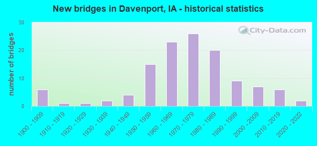
- New bridges - historical statistics
- 61900-1909
- 11910-1919
- 11920-1929
- 21930-1939
- 41940-1949
- 151950-1959
- 231960-1969
- 261970-1979
- 201980-1989
- 91990-1999
- 72000-2009
- 62010-2019
- 22020-2022
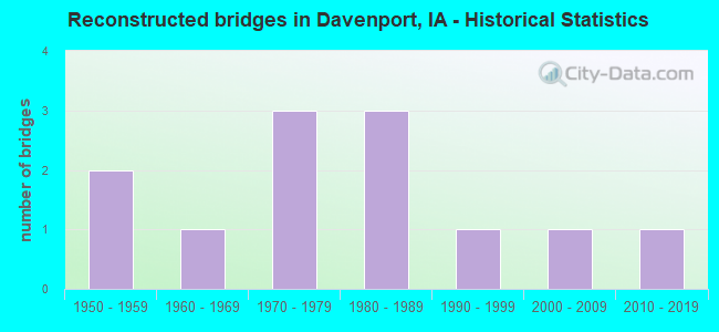
- Reconstructed bridges - Historical Statistics
- 21950-1959
- 11960-1969
- 31970-1979
- 31980-1989
- 11990-1999
- 12000-2009
- 12010-2019
- Bridge Condition - Deck
- 1.4%Excellent
- 5.5%Very good
- 24.7%Good
- 39.7%Satisfactory
- 19.2%Fair
- 5.5%Poor
- 1.4%Serious
- 2.7%Failed
- Bridge Condition - Superstructure
- 1.4%Excellent
- 11.0%Very good
- 23.3%Good
- 38.4%Satisfactory
- 15.1%Fair
- 6.8%Poor
- 1.4%Serious
- 2.7%Failed
- Bridge Condition - Substructure
- 1.4%Excellent
- 11.0%Very good
- 32.9%Good
- 34.2%Satisfactory
- 13.7%Fair
- 2.7%Poor
- 1.4%Serious
- 2.7%Failed
- Bridge Condition - Channel
- 1.9%Excellent
- 14.8%Very good
- 42.6%Good
- 35.2%Satisfactory
- 3.7%Fair
- 1.9%Poor
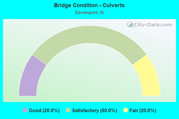
- Bridge Condition - Culverts
- 20.0%Good
- 60.0%Satisfactory
- 20.0%Fair
Find on map >> Show street view
Structure Number: 60072, Location: At the Jct. of Iowa 22 (Lat: 41.491886, Lng: -90.650075), Route carried "on" structure: Interstate 280, Year Built: 1970, Status: Open, Structure Length: 7.19m (23.59ft), Average Daily Traffic: 8,400 (year 2020), Truck Traffic: 39%, Average Future Daily Traffic: 8,400 (year 2042), Design Load: HS 20, Features Intersected: IA 22
Minimum Vertical Clearance: 30+ m (98+ ft), Kilometerpoint: 13.789, Lanes on structure: 2, Lanes under structure: 4, Base Highway Network: Yes, Owner: State Highway Agency, Approaching Roadway Width: 12.2m (40.0ft), Skew: 2 degrees, Material/Design: Steel continuous, Design/Construction: Stringer/Multi-beam, Number Of Spans In Main Unit: 4, Length of Maximum Span: 21.0m (68.9ft), Curb-To-Curb Width: 11.9m (39.0ft), Out-to-Out Width: 13.0m (42.7ft)
Condition: Deck: Satisfactory, Superstructure: Satisfactory, Substructure: Good, Operating Rating: 70.6 metric tons, Method Used To Determine Operating Rating: Load Factor (LF), Inventory Rating: 42.3 metric tons, Method Used To Determine Inventory Rating: Load Factor (LF), Structural Evaluation: Equal to present minimum criteria, Deck Geometry: Equal to present minimum criteria, Underclear: Meets minimum limits, Approach Roadway Alignment: Equal to present desirable criteria, Designated Inspection Frequency: Every 24 months, Inspection Date: Febuary 2022, Deck Structure Type: Concrete Cast-file-Place, Wearing Surface/Protective System: Wearing Surface: Low Slump Concrete
Find on map >> Show street view
Structure Number: 60073, Location: at Jct. US 61 (Lat: 41.508989, Lng: -90.672581), Route carried "on" structure: Interstate 280, Year Built: 1970, Status: Open, Structure Length: 4.97m (16.31ft), Average Daily Traffic: 7,000 (year 2020), Truck Traffic: 46%, Average Future Daily Traffic: 7,000 (year 2040), Design Load: HS 20, Features Intersected: US 61
Minimum Vertical Clearance: 30+ m (98+ ft), Kilometerpoint: 4.841, Lanes on structure: 2, Lanes under structure: 4, Owner: State Highway Agency, Approaching Roadway Width: 12.2m (40.0ft), Skew: 1 degrees, Material/Design: Prestressed concrete, Design/Construction: Stringer/Multi-beam, Number Of Spans In Main Unit: 3, Length of Maximum Span: 25.0m (82.0ft), Curb-To-Curb Width: 11.9m (39.0ft), Out-to-Out Width: 13.0m (42.7ft)
Condition: Deck: Satisfactory, Superstructure: Satisfactory, Substructure: Good, Operating Rating: 72.5 metric tons, Method Used To Determine Operating Rating: Load Factor (LF), Inventory Rating: 24.1 metric tons, Method Used To Determine Inventory Rating: Load Factor (LF), Structural Evaluation: Somewhat better than minimum adequacy, Deck Geometry: Equal to present minimum criteria, Underclear: High priority of corrective action, Approach Roadway Alignment: Equal to present desirable criteria, Designated Inspection Frequency: Every 24 months, Inspection Date: April 2020, Deck Structure Type: Concrete Cast-file-Place, Wearing Surface/Protective System: Wearing Surface: Low Slump Concrete
Find on map >> Show street view
Structure Number: 60074, Location: At Jct. US 61 (Lat: 41.509361, Lng: -90.673044), Route carried "on" structure: Interstate 280, Year Built: 1970, Status: Open, Structure Length: 4.97m (16.31ft), Average Daily Traffic: 7,000 (year 2020), Truck Traffic: 46%, Average Future Daily Traffic: 7,000 (year 2040), Design Load: HS 20, Features Intersected: US 61
Minimum Vertical Clearance: 30+ m (98+ ft), Kilometerpoint: 10.968, Lanes on structure: 2, Lanes under structure: 4, Base Highway Network: Yes, Owner: State Highway Agency, Approaching Roadway Width: 12.2m (40.0ft), Skew: 1 degrees, Material/Design: Prestressed concrete, Design/Construction: Stringer/Multi-beam, Number Of Spans In Main Unit: 3, Length of Maximum Span: 25.0m (82.0ft), Curb-To-Curb Width: 11.9m (39.0ft), Out-to-Out Width: 13.0m (42.7ft)
Condition: Deck: Satisfactory, Superstructure: Satisfactory, Substructure: Good, Operating Rating: 71.3 metric tons, Method Used To Determine Operating Rating: Load Factor (LF), Inventory Rating: 22.3 metric tons, Method Used To Determine Inventory Rating: Load Factor (LF), Structural Evaluation: Somewhat better than minimum adequacy, Deck Geometry: Equal to present minimum criteria, Underclear: High priority of corrective action, Approach Roadway Alignment: Equal to present desirable criteria, Designated Inspection Frequency: Every 24 months, Inspection Date: April 2020, Deck Structure Type: Concrete Cast-file-Place, Wearing Surface/Protective System: Wearing Surface: Low Slump Concrete
Find on map >> Show street view
Structure Number: 60464, Location: 0.8 MI. N OF JCT I-80 (Lat: 41.606125, Lng: -90.565289), Route carried "on" structure: US 61, Year Built: 1981, Status: Open, Structure Length: 10.49m (34.42ft), Average Daily Traffic: 19,250 (year 2020), Truck Traffic: 10%, Average Future Daily Traffic: 19,250 (year 2040), Design Load: HS 20, Features Intersected: DME RR
Minimum Vertical Clearance: 30+ m (98+ ft), Kilometerpoint: 202.002, Lanes on structure: 3, Base Highway Network: Yes, Owner: State Highway Agency, Approaching Roadway Width: 16.5m (54.1ft), Skew: 5 degrees, Material/Design: Steel continuous, Design/Construction: Stringer/Multi-beam, Number Of Spans In Main Unit: 3, Length of Maximum Span: 39.9m (130.9ft), Curb-To-Curb Width: 18.1m (59.4ft), Out-to-Out Width: 18.9m (62.0ft)
Condition: Deck: Satisfactory, Superstructure: Good, Substructure: Satisfactory, Operating Rating: 50.4 metric tons, Method Used To Determine Operating Rating: Allowable Stress (AS), Inventory Rating: 29.7 metric tons, Method Used To Determine Inventory Rating: Allowable Stress (AS), Structural Evaluation: Equal to present minimum criteria, Deck Geometry: Superior to present desirable criteria, Underclear: Better than present minimum criteria, Approach Roadway Alignment: Equal to present desirable criteria, Designated Inspection Frequency: Every 24 months, Inspection Date: April 2020, Deck Structure Type: Concrete Cast-file-Place, Wearing Surface/Protective System: Wearing Surface: Monolithic Concrete, Deck Protection: Epoxy Coated Reinforcing
Find on map >> Show street view
Structure Number: 604645, Location: 0.8 MI. N OF JCT I-80 (Lat: 41.607094, Lng: -90.565219), Route carried "on" structure: US 61, Year Built: 1981, Status: Open, Structure Length: 10.52m (34.51ft), Average Daily Traffic: 15,800 (year 2020), Truck Traffic: 11%, Average Future Daily Traffic: 15,800 (year 2040), Design Load: HS 20, Features Intersected: DME RR
Minimum Vertical Clearance: 30+ m (98+ ft), Kilometerpoint: 108.014, Lanes on structure: 3, Owner: State Highway Agency, Approaching Roadway Width: 16.8m (55.1ft), Skew: 5 degrees, Material/Design: Steel continuous, Design/Construction: Stringer/Multi-beam, Number Of Spans In Main Unit: 3, Length of Maximum Span: 39.9m (130.9ft), Curb-To-Curb Width: 16.1m (52.8ft), Out-to-Out Width: 17.1m (56.1ft)
Condition: Deck: Satisfactory, Superstructure: Satisfactory, Substructure: Satisfactory, Operating Rating: 48.5 metric tons, Method Used To Determine Operating Rating: Allowable Stress (AS), Inventory Rating: 28.8 metric tons, Method Used To Determine Inventory Rating: Allowable Stress (AS), Structural Evaluation: Equal to present minimum criteria, Deck Geometry: Better than present minimum criteria, Underclear: Equal to present minimum criteria, Approach Roadway Alignment: Equal to present desirable criteria, Designated Inspection Frequency: Every 24 months, Inspection Date: April 2020, Deck Structure Type: Concrete Cast-file-Place, Wearing Surface/Protective System: Wearing Surface: Monolithic Concrete, Deck Protection: Epoxy Coated Reinforcing
Find on map >> Show street view
Structure Number: 60465, Location: 1.1 MI. N OF JCT. I-80 (Lat: 41.610603, Lng: -90.563189), Route carried "on" structure: US 61, Year Built: 1981, Status: Open, Structure Length: 8.05m (26.41ft), Average Daily Traffic: 15,800 (year 2020), Truck Traffic: 11%, Average Future Daily Traffic: 15,800 (year 2040), Design Load: HS 20, Features Intersected: 210TH ST
Minimum Vertical Clearance: 30+ m (98+ ft), Kilometerpoint: 202.528, Lanes on structure: 2, Lanes under structure: 5, Base Highway Network: Yes, Owner: State Highway Agency, Approaching Roadway Width: 12.2m (40.0ft), Skew: 1 degrees, Material/Design: Steel continuous, Design/Construction: Stringer/Multi-beam, Number Of Spans In Main Unit: 3, Length of Maximum Span: 38.1m (125.0ft), Curb-To-Curb Width: 12.3m (40.4ft), Out-to-Out Width: 13.2m (43.3ft)
Condition: Deck: Fair, Superstructure: Satisfactory, Substructure: Good, Operating Rating: 55.9 metric tons, Method Used To Determine Operating Rating: Allowable Stress (AS), Inventory Rating: 32.5 metric tons, Method Used To Determine Inventory Rating: Allowable Stress (AS), Structural Evaluation: Equal to present minimum criteria, Deck Geometry: Better than present minimum criteria, Underclear: Equal to present minimum criteria, Approach Roadway Alignment: Equal to present desirable criteria, Designated Inspection Frequency: Every 24 months, Inspection Date: April 2020, Deck Structure Type: Concrete Cast-file-Place, Wearing Surface/Protective System: Wearing Surface: Monolithic Concrete, Deck Protection: Epoxy Coated Reinforcing
Find on map >> Show street view
Structure Number: 604655, Location: 1.1 MI. N OF JCT. I-80 (Lat: 41.611428, Lng: -90.563322), Route carried "on" structure: US 61, Year Built: 1981, Status: Open, Structure Length: 8.02m (26.31ft), Average Daily Traffic: 15,050 (year 2020), Truck Traffic: 11%, Average Future Daily Traffic: 15,050 (year 2040), Design Load: HS 20, Features Intersected: 210TH ST
Minimum Vertical Clearance: 30+ m (98+ ft), Kilometerpoint: 107.506, Lanes on structure: 3, Lanes under structure: 5, Owner: State Highway Agency, Approaching Roadway Width: 15.9m (52.2ft), Skew: 1 degrees, Material/Design: Steel continuous, Design/Construction: Stringer/Multi-beam, Number Of Spans In Main Unit: 3, Length of Maximum Span: 38.1m (125.0ft), Curb-To-Curb Width: 15.6m (51.2ft), Out-to-Out Width: 16.7m (54.8ft)
Condition: Deck: Fair, Superstructure: Fair, Substructure: Satisfactory, Operating Rating: 66.6 metric tons, Method Used To Determine Operating Rating: Load Factor (LF), Inventory Rating: 40.0 metric tons, Method Used To Determine Inventory Rating: Load Factor (LF), Structural Evaluation: Somewhat better than minimum adequacy, Deck Geometry: Equal to present minimum criteria, Underclear: Equal to present minimum criteria, Approach Roadway Alignment: Better than present minimum criteria, Designated Inspection Frequency: Every 24 months, Inspection Date: April 2020, Deck Structure Type: Concrete Cast-file-Place, Wearing Surface/Protective System: Wearing Surface: Monolithic Concrete, Deck Protection: Epoxy Coated Reinforcing
Find on map >> Show street view
Structure Number: 60467, Location: 1.1 MI. N OF JCT. I-80 (Lat: 41.610681, Lng: -90.562886), Route carried "on" structure: Ramp US 61, Year Built: 1981, Status: Open, Structure Length: 8.20m (26.90ft), Average Daily Traffic: 2,290 (year 2020), Truck Traffic: 11%, Average Future Daily Traffic: 2,290 (year 2040), Design Load: HS 20, Features Intersected: 210TH ST
Minimum Vertical Clearance: 30+ m (98+ ft), Kilometerpoint: 0.531, Lanes on structure: 1, Lanes under structure: 5, Owner: State Highway Agency, Approaching Roadway Width: 9.1m (29.9ft), Skew: 1 degrees, Material/Design: Steel continuous, Design/Construction: Stringer/Multi-beam, Number Of Spans In Main Unit: 3, Length of Maximum Span: 39.0m (128.0ft), Curb-To-Curb Width: 8.5m (27.9ft), Out-to-Out Width: 9.5m (31.2ft)
Condition: Deck: Fair, Superstructure: Satisfactory, Substructure: Satisfactory, Operating Rating: 59.2 metric tons, Method Used To Determine Operating Rating: Load Factor (LF), Inventory Rating: 35.6 metric tons, Method Used To Determine Inventory Rating: Load Factor (LF), Structural Evaluation: Equal to present minimum criteria, Deck Geometry: Superior to present desirable criteria, Underclear: Better than present minimum criteria, Approach Roadway Alignment: Better than present minimum criteria, Designated Inspection Frequency: Every 24 months, Inspection Date: April 2020, Deck Structure Type: Concrete Cast-file-Place, Wearing Surface/Protective System: Wearing Surface: Monolithic Concrete, Deck Protection: Epoxy Coated Reinforcing
Find on map >> Show street view
Structure Number: 3055, Location: 000000000 (Lat: 41.538425, Lng: -90.540994), Route carried "under" structure: City street , Year Built: 1968, Structure Length: 0. m, Average Daily Traffic: 5,100 (year 2018), Features Intersected: JERSEY RD, Facility Carried by Structure: LOCUST ST
Minimum Vertical Clearance: 30+ m (98+ ft), Kilometerpoint: 0.856, Lanes on structure: 4, Lanes under structure: 2, Material/Design: Prestressed concrete, Design/Construction: Stringer/Multi-beam, Length of Maximum Span: 18.0m (59.1ft)
Find on map >> Show street view
Structure Number: 341, Location: 1.6 MI. E OF JCT. US 61 (Lat: 41.595664, Lng: -90.539286), Route carried "under" structure: Interstate 80, Year Built: 1963, Structure Length: 0. m, Average Daily Traffic: 43,900 (year 2020), Truck Traffic: 23%, Features Intersected: I-80, Facility Carried by Structure: JERSEY RIDGE RD
Minimum Vertical Clearance: 30+ m (98+ ft), Kilometerpoint: 477.534, Lanes on structure: 2, Lanes under structure: 5, Material/Design: Prestressed concrete, Design/Construction: Stringer/Multi-beam, Length of Maximum Span: 21.0m (68.9ft)
Find on map >> Show street view
Structure Number: 46805, Location: 0.8 MI.E.OF JCT I-80/280 (Lat: 41.591817, Lng: -90.676358), Route carried "under" structure: Interstate 280, Year Built: 1971, Structure Length: 0. m, Average Daily Traffic: 17,400 (year 2020), Truck Traffic: 42%, Features Intersected: I-280 & US 61, Facility Carried by Structure: US 6
Minimum Vertical Clearance: 30+ m (98+ ft), Kilometerpoint: 1.761, Lanes on structure: 2, Lanes under structure: 5, Material/Design: Steel continuous, Design/Construction: Stringer/Multi-beam, Length of Maximum Span: 34.4m (112.9ft)
Find on map >> Show street view
Structure Number: 46871, Location: IA 461 OVER IA 22 (Lat: 41.505361, Lng: -90.642439), Route carried "under" structure: State highway 22, Year Built: 2020, Structure Length: 0. m, Average Daily Traffic: 4,410 (year 2020), Truck Traffic: 10%, Features Intersected: IA 22, Facility Carried by Structure: IA 461
Minimum Vertical Clearance: 30+ m (98+ ft), Kilometerpoint: 157.453, Lanes on structure: 5, Lanes under structure: 4, Material/Design: Prestressed concrete, Design/Construction: Stringer/Multi-beam, Length of Maximum Span: 31.1m (102.0ft)
Find on map >> Show street view
Structure Number: 4696, Location: AT JCT. I-80 (Lat: 41.595811, Lng: -90.570031), Route carried "under" structure: Interstate 80, Year Built: 1963, Structure Length: 0. m, Average Daily Traffic: 34,700 (year 2020), Truck Traffic: 26%, Features Intersected: I 80, Facility Carried by Structure: NB US 61
Minimum Vertical Clearance: 30+ m (98+ ft), Kilometerpoint: 474.950, Lanes on structure: 3, Lanes under structure: 6, Material/Design: Prestressed concrete, Design/Construction: Stringer/Multi-beam, Length of Maximum Span: 23.5m (77.1ft)
Find on map >> Show street view
Structure Number: 4697, Location: AT JCT. I-80 (Lat: 41.596564, Lng: -90.570161), Route carried "under" structure: Interstate 80, Year Built: 1963, Structure Length: 0. m, Average Daily Traffic: 15,600 (year 2020), Truck Traffic: 31%, Features Intersected: I-80, Facility Carried by Structure: SB US 61
Minimum Vertical Clearance: 30+ m (98+ ft), Kilometerpoint: 474.919, Lanes on structure: 3, Lanes under structure: 6, Material/Design: Prestressed concrete, Design/Construction: Stringer/Multi-beam, Length of Maximum Span: 23.5m (77.1ft)
Find on map >> Show street view
Structure Number: 4702, Location: at Davenport (Lat: 41.515650, Lng: -90.581786), Route carried "under" structure: US 67, Year Built: 1940, Structure Length: 0. m, Average Daily Traffic: 8,000 (year 2020), Truck Traffic: 3%, Features Intersected: MISS RVR, RR & IA 461
Minimum Vertical Clearance: 30+ m (98+ ft), Kilometerpoint: 88.182, Lanes on structure: 4, Lanes under structure: 4, Material/Design: Steel, Design/Construction: Arch - Thru, Length of Maximum Span: 164.0m (538.1ft)
Find on map >> Show street view
Structure Number: 4703, Location: 1.3 mi. N of Rt. Beginnin (Lat: 41.520967, Lng: -90.568136), Route carried "under" structure: US 67, Year Built: 1942, Structure Length: 0. m, Average Daily Traffic: 12,000 (year 2020), Truck Traffic: 5%, Features Intersected: US 67 & MISSISSIPPI RIVE, Facility Carried by Structure: ARSENAL ISL RD
Minimum Vertical Clearance: 30+ m (98+ ft), Kilometerpoint: 2.086, Lanes on structure: 2, Lanes under structure: 4, Material/Design: Steel, Design/Construction: Stringer/Multi-beam, Length of Maximum Span: 16.8m (55.1ft)
Find on map >> Show street view
Structure Number: 4722, Location: AT JCT. I-80 (Lat: 41.599697, Lng: -90.618900), Route carried "under" structure: Interstate 80, Year Built: 1959, Structure Length: 0. m, Average Daily Traffic: 13,400 (year 2020), Truck Traffic: 36%, Features Intersected: I-80, Facility Carried by Structure: IA 130 WB
Minimum Vertical Clearance: 30+ m (98+ ft), Kilometerpoint: 470.826, Lanes on structure: 2, Lanes under structure: 4, Material/Design: Steel continuous, Design/Construction: Stringer/Multi-beam, Length of Maximum Span: 29.0m (95.1ft)
Find on map >> Show street view
Structure Number: 4723, Location: AT JCT. I-80 (Lat: 41.600150, Lng: -90.619892), Route carried "under" structure: Interstate 80, Year Built: 1959, Structure Length: 0. m, Average Daily Traffic: 13,400 (year 2020), Truck Traffic: 36%, Features Intersected: I-80, Facility Carried by Structure: EB IA 130
Minimum Vertical Clearance: 30+ m (98+ ft), Kilometerpoint: 470.794, Lanes on structure: 2, Lanes under structure: 4, Material/Design: Steel continuous, Design/Construction: Stringer/Multi-beam, Length of Maximum Span: 29.0m (95.1ft)
Find on map >> Show street view
Structure Number: 47371, Location: 1.5 MI. E Jct. I-80 (Lat: 41.574847, Lng: -90.522603), Route carried "under" structure: Interstate 74, Year Built: 1990, Structure Length: 0. m, Average Daily Traffic: 13,700 (year 2020), Truck Traffic: 17%, Features Intersected: I-74, Facility Carried by Structure: E 53RD ST
Minimum Vertical Clearance: 30+ m (98+ ft), Kilometerpoint: 2.441, Lanes on structure: 6, Lanes under structure: 6, Material/Design: Prestressed concrete, Design/Construction: Stringer/Multi-beam, Length of Maximum Span: 25.0m (82.0ft)
Find on map >> Show street view
Structure Number: 47381, Location: 0.5 mi. E of jct. I-80 (Lat: 41.589611, Lng: -90.523597), Route carried "under" structure: Interstate 74, Year Built: 2015, Structure Length: 0. m, Average Daily Traffic: 24,000 (year 2020), Truck Traffic: 11%, Features Intersected: I 74, Facility Carried by Structure: VETS MEMORIAL PKWY
Minimum Vertical Clearance: 30+ m (98+ ft), Kilometerpoint: 0.795, Lanes on structure: 4, Lanes under structure: 4, Material/Design: Prestressed concrete, Design/Construction: Stringer/Multi-beam, Length of Maximum Span: 35.4m (116.1ft)
Find on map >> Show street view
Structure Number: 4739, Location: At jct. I-80 (Lat: 41.595872, Lng: -90.525036), Route carried "under" structure: Interstate 80, Year Built: 1967, Structure Length: 0. m, Average Daily Traffic: 13,200 (year 2020), Truck Traffic: 30%, Features Intersected: I 80, Facility Carried by Structure: I-74 WB
Minimum Vertical Clearance: 30+ m (98+ ft), Kilometerpoint: 478.714, Lanes on structure: 2, Lanes under structure: 4, Material/Design: Steel continuous, Design/Construction: Stringer/Multi-beam, Length of Maximum Span: 22.9m (75.1ft)
Find on map >> Show street view
Structure Number: 474, Location: At jct. I-80 (Lat: 41.596533, Lng: -90.525647), Route carried "under" structure: Interstate 80, Year Built: 1967, Structure Length: 0. m, Average Daily Traffic: 12,100 (year 2020), Truck Traffic: 33%, Features Intersected: I 80, Facility Carried by Structure: I-74 EB
Minimum Vertical Clearance: 30+ m (98+ ft), Kilometerpoint: 478.693, Lanes on structure: 1, Lanes under structure: 4, Material/Design: Steel continuous, Design/Construction: Stringer/Multi-beam, Length of Maximum Span: 22.9m (75.1ft)
Find on map >> Show street view
Structure Number: 4746, Location: 0.5 MI. W OF JCT. I-280 (Lat: 41.603431, Lng: -90.685672), Route carried "under" structure: Interstate 80, Year Built: 1959, Structure Length: 0. m, Average Daily Traffic: 26,400 (year 2020), Truck Traffic: 40%, Features Intersected: I-80 & US 6, Facility Carried by Structure: N BUFFALO AVE
Minimum Vertical Clearance: 30+ m (98+ ft), Kilometerpoint: 465.231, Lanes on structure: 2, Lanes under structure: 5, Material/Design: Prestressed concrete, Design/Construction: Stringer/Multi-beam, Length of Maximum Span: 21.6m (70.9ft)
Find on map >> Show street view
Structure Number: 4749, Location: 1.4 mi. W of jct. IA 130 (Lat: 41.601372, Lng: -90.646464), Route carried "under" structure: Interstate 80, Year Built: 1959, Structure Length: 0. m, Average Daily Traffic: 31,600 (year 2020), Truck Traffic: 34%, Features Intersected: I-80, Facility Carried by Structure: WISCONSIN AVE
Minimum Vertical Clearance: 30+ m (98+ ft), Kilometerpoint: 468.523, Lanes on structure: 2, Lanes under structure: 4, Material/Design: Prestressed concrete, Design/Construction: Stringer/Multi-beam, Length of Maximum Span: 21.0m (68.9ft)
Find on map >> Show street view
Structure Number: 4752, Location: 1.1 MI. E OF IOWA #130 (Lat: 41.599481, Lng: -90.597958), Route carried "under" structure: Interstate 80, Year Built: 1959, Structure Length: 0. m, Average Daily Traffic: 36,700 (year 2020), Truck Traffic: 30%, Features Intersected: I-80, Facility Carried by Structure: N DIVISION ST
Minimum Vertical Clearance: 30+ m (98+ ft), Kilometerpoint: 472.581, Lanes on structure: 2, Lanes under structure: 4, Material/Design: Prestressed concrete, Design/Construction: Stringer/Multi-beam, Length of Maximum Span: 21.0m (68.9ft)
Find on map >> Show street view
Structure Number: 4761, Location: 3.3 MI.E OF JCT. US #61 (Lat: 41.596028, Lng: -90.507108), Route carried "under" structure: Interstate 80, Year Built: 1963, Structure Length: 0. m, Average Daily Traffic: 28,500 (year 2020), Truck Traffic: 29%, Features Intersected: I-80, Facility Carried by Structure: UTICA RIDGE RD
Minimum Vertical Clearance: 30+ m (98+ ft), Kilometerpoint: 480.225, Lanes on structure: 2, Lanes under structure: 4, Material/Design: Prestressed concrete, Design/Construction: Stringer/Multi-beam, Length of Maximum Span: 21.0m (68.9ft)
Find on map >> Show street view
Structure Number: 4774, Location: AT JCT. I-280 (Lat: 41.602617, Lng: -90.677894), Route carried "under" structure: Interstate 80, Year Built: 1960, Structure Length: 0. m, Average Daily Traffic: 21,300 (year 2020), Truck Traffic: 39%, Features Intersected: EB I-80
Minimum Vertical Clearance: 30+ m (98+ ft), Kilometerpoint: 465.855, Lanes on structure: 2, Lanes under structure: 2, Material/Design: Steel, Design/Construction: Stringer/Multi-beam, Length of Maximum Span: 27.1m (88.9ft)
Find on map >> Show street view
Structure Number: 4775, Location: AT JCT. I-80 (Lat: 41.601006, Lng: -90.676061), Route carried "under" structure: Ramp Interstate 280, Year Built: 1960, Structure Length: 0. m, Average Daily Traffic: 4,180 (year 2020), Truck Traffic: 58%, Features Intersected: I 280 WB
Minimum Vertical Clearance: 30+ m (98+ ft), Kilometerpoint: 15.102, Lanes on structure: 2, Lanes under structure: 2, Material/Design: Steel, Design/Construction: Stringer/Multi-beam, Length of Maximum Span: 21.3m (69.9ft)
Find on map >> Show street view
Structure Number: 4776, Location: 0.1 MI. E OF JCT. I-280 (Lat: 41.602989, Lng: -90.673892), Route carried "under" structure: Interstate 80, Year Built: 1960, Structure Length: 0. m, Average Daily Traffic: 21,300 (year 2020), Truck Traffic: 39%, Features Intersected: EB I-80
Minimum Vertical Clearance: 30+ m (98+ ft), Kilometerpoint: 466.180, Lanes on structure: 2, Lanes under structure: 2, Material/Design: Steel, Design/Construction: Stringer/Multi-beam, Length of Maximum Span: 25.0m (82.0ft)
Find on map >> Show street view
Structure Number: 302225, Location: 2.0 mi. N of Jct. US 61 (Lat: 41.538194, Lng: -90.677375), Route carried "under" structure: Interstate 280, Year Built: 1971, Structure Length: 0. m, Average Daily Traffic: 17,700 (year 2020), Truck Traffic: 41%, Features Intersected: I-280, Facility Carried by Structure: W LOCUST ST
Minimum Vertical Clearance: 30+ m (98+ ft), Kilometerpoint: 7.722, Lanes on structure: 2, Lanes under structure: 4, Material/Design: Prestressed concrete, Design/Construction: Stringer/Multi-beam, Length of Maximum Span: 28.0m (91.9ft)
Find on map >> Show street view
Structure Number: 505075, Location: Davenport (Lat: 41.586439, Lng: -90.563394), Route carried "under" structure: City street , Year Built: 2009, Structure Length: 0. m, Average Daily Traffic: 2,200 (year 2010), Features Intersected: IC&E RR, Facility Carried by Structure: 65TH STREET
Minimum Vertical Clearance: 30+ m (98+ ft), Kilometerpoint: 0.000, Lanes on structure: 4, Material/Design: Concrete continuous, Design/Construction: Slab, Length of Maximum Span: 17.7m (58.1ft)
Find on map >> Show street view
Structure Number: 60069, Location: IN ROCK ISLAND (Lat: 41.483106, Lng: -90.637639), Route carried "under" structure: City street , Year Built: 1970, Structure Length: 0. m, Average Daily Traffic: 590 (year 2002), Features Intersected: MISSISSIPPI RIVER & ROAD, Facility Carried by Structure: I-280
Minimum Vertical Clearance: 30+ m (98+ ft), Kilometerpoint: 3.405, Lanes on structure: 4, Lanes under structure: 2, Material/Design: Steel, Design/Construction: Arch - Thru, Length of Maximum Span: 173.7m (569.9ft)
Find on map >> Show street view
Structure Number: 60071, Location: At jct. IA 22 (Lat: 41.491692, Lng: -90.649253), Route carried "under" structure: State highway 22, Year Built: 1970, Structure Length: 0. m, Average Daily Traffic: 2,750 (year 2020), Truck Traffic: 18%, Features Intersected: IA 22, Facility Carried by Structure: I 280 WB
Minimum Vertical Clearance: 30+ m (98+ ft), Kilometerpoint: 155.817, Lanes on structure: 2, Lanes under structure: 4, Material/Design: Steel continuous, Design/Construction: Stringer/Multi-beam, Length of Maximum Span: 21.0m (68.9ft)
Find on map >> Show street view
Structure Number: 60072, Location: At the Jct. of Iowa 22 (Lat: 41.491886, Lng: -90.650075), Route carried "under" structure: State highway 22, Year Built: 1970, Structure Length: 0. m, Average Daily Traffic: 2,750 (year 2020), Truck Traffic: 18%, Features Intersected: IA 22, Facility Carried by Structure: I 280 EB
Minimum Vertical Clearance: 30+ m (98+ ft), Kilometerpoint: 155.786, Lanes on structure: 2, Lanes under structure: 4, Material/Design: Steel continuous, Design/Construction: Stringer/Multi-beam, Length of Maximum Span: 21.0m (68.9ft)
Find on map >> Show street view
Structure Number: 60073, Location: at Jct. US 61 (Lat: 41.508989, Lng: -90.672581), Route carried "under" structure: US 61, Year Built: 1970, Structure Length: 0. m, Average Daily Traffic: 5,750 (year 2020), Truck Traffic: 12%, Features Intersected: US 61, Facility Carried by Structure: I-280 (NB-WB)
Minimum Vertical Clearance: 30+ m (98+ ft), Kilometerpoint: 180.824, Lanes on structure: 2, Lanes under structure: 4, Material/Design: Prestressed concrete, Design/Construction: Stringer/Multi-beam, Length of Maximum Span: 25.0m (82.0ft)
Find on map >> Show street view
Structure Number: 60074, Location: At Jct. US 61 (Lat: 41.509361, Lng: -90.673044), Route carried "under" structure: US 61, Year Built: 1970, Structure Length: 0. m, Average Daily Traffic: 5,750 (year 2020), Truck Traffic: 12%, Features Intersected: US 61, Facility Carried by Structure: I-280 (SB-EB)
Minimum Vertical Clearance: 30+ m (98+ ft), Kilometerpoint: 180.795, Lanes on structure: 2, Lanes under structure: 4, Material/Design: Prestressed concrete, Design/Construction: Stringer/Multi-beam, Length of Maximum Span: 25.0m (82.0ft)
Find on map >> Show street view
Structure Number: 60465, Location: 1.1 MI. N OF JCT. I-80 (Lat: 41.610603, Lng: -90.563189), Route carried "under" structure: Ramp US 61, Year Built: 1981, Structure Length: 0. m, Average Daily Traffic: 1,145 (year 2020), Truck Traffic: 11%, Features Intersected: 210TH ST
Minimum Vertical Clearance: 30+ m (98+ ft), Kilometerpoint: 1.131, Lanes on structure: 2, Lanes under structure: 5, Material/Design: Steel continuous, Design/Construction: Stringer/Multi-beam, Length of Maximum Span: 38.1m (125.0ft)
Find on map >> Show street view
Structure Number: 60465, Location: 1.1 MI. N OF JCT. I-80 (Lat: 41.610603, Lng: -90.563189), Route carried "under" structure: County highway , Year Built: 1981, Structure Length: 0. m, Average Daily Traffic: 2,550 (year 2018), Truck Traffic: 8%, Features Intersected: 210TH ST, Facility Carried by Structure: NB US 61
Minimum Vertical Clearance: 30+ m (98+ ft), Kilometerpoint: 7.163, Lanes on structure: 2, Lanes under structure: 5, Material/Design: Steel continuous, Design/Construction: Stringer/Multi-beam, Length of Maximum Span: 38.1m (125.0ft)
Find on map >> Show street view
Structure Number: 604655, Location: 1.1 MI. N OF JCT. I-80 (Lat: 41.611428, Lng: -90.563322), Route carried "under" structure: Ramp US 61, Year Built: 1981, Structure Length: 0. m, Average Daily Traffic: 900 (year 2020), Truck Traffic: 6%, Features Intersected: 210TH ST
Minimum Vertical Clearance: 30+ m (98+ ft), Kilometerpoint: 0.011, Lanes on structure: 3, Lanes under structure: 5, Material/Design: Steel continuous, Design/Construction: Stringer/Multi-beam, Length of Maximum Span: 38.1m (125.0ft)
Find on map >> Show street view
Structure Number: 604655, Location: 1.1 MI. N OF JCT. I-80 (Lat: 41.611428, Lng: -90.563322), Route carried "under" structure: County highway , Year Built: 1981, Structure Length: 0. m, Average Daily Traffic: 2,550 (year 2018), Truck Traffic: 8%, Features Intersected: 210TH ST, Facility Carried by Structure: SB US 61
Minimum Vertical Clearance: 30+ m (98+ ft), Kilometerpoint: 7.194, Lanes on structure: 3, Lanes under structure: 5, Material/Design: Steel continuous, Design/Construction: Stringer/Multi-beam, Length of Maximum Span: 38.1m (125.0ft)
Find on map >> Show street view
Structure Number: 60467, Location: 1.1 MI. N OF JCT. I-80 (Lat: 41.610681, Lng: -90.562886), Route carried "under" structure: Ramp US 61, Year Built: 1981, Structure Length: 0. m, Average Daily Traffic: 2,290 (year 2020), Truck Traffic: 11%, Features Intersected: 210TH ST
Minimum Vertical Clearance: 30+ m (98+ ft), Kilometerpoint: 1.106, Lanes on structure: 1, Lanes under structure: 5, Material/Design: Steel continuous, Design/Construction: Stringer/Multi-beam, Length of Maximum Span: 39.0m (128.0ft)
Find on map >> Show street view
Structure Number: 60467, Location: 1.1 MI. N OF JCT. I-80 (Lat: 41.610681, Lng: -90.562886), Route carried "under" structure: County highway , Year Built: 1981, Structure Length: 0. m, Average Daily Traffic: 5,100 (year 2018), Truck Traffic: 8%, Features Intersected: 210TH ST, Facility Carried by Structure: RAMP US 61
Minimum Vertical Clearance: 30+ m (98+ ft), Kilometerpoint: 7.137, Lanes on structure: 1, Lanes under structure: 5, Material/Design: Steel continuous, Design/Construction: Stringer/Multi-beam, Length of Maximum Span: 39.0m (128.0ft)