Bridge Statistics for Dayton, Ohio (OH)
Condition, Traffic, Stress, Structural Evaluation, Project Costs
- National Bridge Inventory (NBI) Statistics
- 245Number of bridges
- 4,478ft / 1,365mTotal length
- $16,503,000Total costs
- 7,097,912Total average daily traffic
- 621,897Total average daily truck traffic
- National Bridge Inventory (NBI) Registered Bridges for Dayton
- No street view available for this location
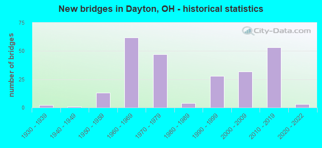
- New bridges - historical statistics
- 21930-1939
- 11940-1949
- 131950-1959
- 621960-1969
- 471970-1979
- 41980-1989
- 281990-1999
- 322000-2009
- 532010-2019
- 32020-2022

- Reconstructed bridges - Historical Statistics
- 21970-1979
- 31980-1989
- 21990-1999
- 92000-2009
- 22010-2019
- 12020-2022


- Bridge Condition - Deck
- 11.7%Excellent
- 30.7%Very good
- 43.8%Good
- 9.5%Satisfactory
- 4.4%Fair

- Bridge Condition - Superstructure
- 18.2%Excellent
- 28.5%Very good
- 35.8%Good
- 13.1%Satisfactory
- 4.4%Fair

- Bridge Condition - Substructure
- 5.8%Excellent
- 34.3%Very good
- 43.1%Good
- 11.7%Satisfactory
- 3.6%Fair
- 1.5%Poor

- Bridge Condition - Channel
- 21.0%Excellent
- 17.7%Very good
- 32.3%Good
- 14.5%Satisfactory
- 9.7%Fair
- 4.8%Poor

- Bridge Condition - Culverts
- 55.6%Very good
- 11.1%Good
- 33.3%Satisfactory
Find on map >> Show street view
Structure Number: 3800075, Location: 2.98 MI S OF SR 179 (Lat: 40.650011, Lng: -82.198839), Route carried "on" structure: State highway 3, Year Built: 1991, Status: Open, Structure Length: 2.10m (6.89ft), Average Daily Traffic: 2,639 (year 2015), Truck Traffic: 9%, Average Future Daily Traffic: 3,663 (year 2035), Design Load: HS 20+Mod, Features Intersected: PLUM RUN
Minimum Vertical Clearance: 30+ m (98+ ft), Kilometerpoint: 2.189, Lanes on structure: 2, Base Highway Network: Yes, Owner: State Highway Agency, Approaching Roadway Width: 9.8m (32.2ft), Skew: 1 degrees, Material/Design: Prestressed concrete, Design/Construction: Box Beam or Girders - Multiple, Number Of Spans In Main Unit: 1, Length of Maximum Span: 19.8m (65.0ft), Curb-To-Curb Width: 11.1m (36.4ft), Out-to-Out Width: 20.9m (68.6ft)
Condition: Deck: Good, Superstructure: Very good, Substructure: Good, Channel: Satisfactory, Operating Rating: 42.1 metric tons, Method Used To Determine Operating Rating: Load Factor (LF) rating reported by rating factor (RF) method using MS18 loading, Inventory Rating: 32.4 metric tons, Method Used To Determine Inventory Rating: Load Factor (LF) rating reported by rating factor (RF) method using MS18 loading, Structural Evaluation: Better than present minimum criteria, Deck Geometry: Somewhat better than minimum adequacy, Waterway Adequacy: Superior to present desirable criteria, Approach Roadway Alignment: Equal to present desirable criteria, Designated Inspection Frequency: Every 24 months, Inspection Date: July 2020, Deck Structure Type: Concrete Cast-file-Place, Wearing Surface/Protective System: Wearing Surface: Bituminous, Membrane: Built-up
Find on map >> Show street view
Structure Number: 5700396, Location: 4.42MI.S. OF JCT. USR-35 (Lat: 39.711039, Lng: -84.278550), Route carried "on" structure: State highway 4, Year Built: 1931, Year Reconstructed: 1982, Status: Open, Structure Length: 1.46m (4.79ft), Average Daily Traffic: 4,206 (year 2015), Truck Traffic: 7%, Average Future Daily Traffic: 5,838 (year 2035), Design Load: HS 20, Features Intersected: OPOSSUM CREEK
Minimum Vertical Clearance: 30+ m (98+ ft), Kilometerpoint: 16.190, Lanes on structure: 2, Base Highway Network: Yes, Owner: State Highway Agency, Approaching Roadway Width: 9.1m (29.9ft), Skew: 4 degrees, Material/Design: Prestressed concrete, Design/Construction: Box Beam or Girders - Multiple, Number Of Spans In Main Unit: 1, Length of Maximum Span: 14.3m (46.9ft), Curb-To-Curb Width: 9.2m (30.2ft), Out-to-Out Width: 9.2m (30.2ft)
Condition: Deck: Very good, Superstructure: Very good, Substructure: Very good, Channel: Good, Operating Rating: 42.1 metric tons, Method Used To Determine Operating Rating: Load Factor (LF) rating reported by rating factor (RF) method using MS18 loading, Inventory Rating: 32.4 metric tons, Method Used To Determine Inventory Rating: Load Factor (LF) rating reported by rating factor (RF) method using MS18 loading, Structural Evaluation: Equal to present desirable criteria, Deck Geometry: Meets minimum limits, Waterway Adequacy: Equal to present desirable criteria, Approach Roadway Alignment: Equal to present desirable criteria, Designated Inspection Frequency: Every 24 months, Inspection Date: October 2021, Deck Structure Type: Concrete Cast-file-Place, Wearing Surface/Protective System: Wearing Surface: Integral Concrete
Find on map >> Show street view
Structure Number: 5700426, Location: 4.03MI.S. OF JCT. USR-35 (Lat: 39.715631, Lng: -84.274581), Route carried "on" structure: State highway 4, Year Built: 1930, Year Reconstructed: 1982, Status: Open, Structure Length: 1.19m (3.90ft), Average Daily Traffic: 4,206 (year 2015), Truck Traffic: 7%, Average Future Daily Traffic: 5,838 (year 2035), Design Load: HS 20, Features Intersected: TRIBUTARY OPOSSUM CREEK
Minimum Vertical Clearance: 30+ m (98+ ft), Kilometerpoint: 16.834, Lanes on structure: 2, Base Highway Network: Yes, Owner: State Highway Agency, Approaching Roadway Width: 9.8m (32.2ft), Material/Design: Prestressed concrete, Design/Construction: Box Beam or Girders - Multiple, Number Of Spans In Main Unit: 1, Length of Maximum Span: 11.6m (38.1ft), Curb-To-Curb Width: 9.8m (32.2ft), Out-to-Out Width: 9.8m (32.2ft)
Condition: Deck: Very good, Superstructure: Very good, Substructure: Very good, Channel: Excellent, Operating Rating: 42.1 metric tons, Method Used To Determine Operating Rating: Load Factor (LF) rating reported by rating factor (RF) method using MS18 loading, Inventory Rating: 32.4 metric tons, Method Used To Determine Inventory Rating: Load Factor (LF) rating reported by rating factor (RF) method using MS18 loading, Structural Evaluation: Equal to present desirable criteria, Deck Geometry: Meets minimum limits, Waterway Adequacy: Equal to present desirable criteria, Approach Roadway Alignment: Equal to present desirable criteria, Designated Inspection Frequency: Every 24 months, Inspection Date: October 2021, Deck Structure Type: Concrete Cast-file-Place, Wearing Surface/Protective System: Wearing Surface: Integral Concrete
Find on map >> Show street view
Structure Number: 5700485, Location: .13MI.E. OF JCT. IR75 (Lat: 39.753981, Lng: -84.202869), Route carried "on" structure: County highway 117, Year Built: 2003, Status: Open, Structure Length: 19.00m (62.34ft), Average Daily Traffic: 5,692 (year 2015), Truck Traffic: 7%, Average Future Daily Traffic: 7,900 (year 2035), Design Load: HS 25 or greater, Features Intersected: GREAT MIAMI RIVER, Facility Carried by Structure: W. 5TH ST SR4
Minimum Vertical Clearance: 30+ m (98+ ft), Kilometerpoint: 4.849, Lanes on structure: 4, Owner: City or Municipal Highway Agency, Approaching Roadway Width: 19.5m (64.0ft), Material/Design: Prestressed concrete continuous, Design/Construction: Stringer/Multi-beam, Number Of Spans In Main Unit: 5, Length of Maximum Span: 37.6m (123.4ft), Curb or Sidewalk Widths: Left: 3.0m (9.8ft), Right: 3.0m (9.8ft), Curb-To-Curb Width: 19.5m (64.0ft), Out-to-Out Width: 27.3m (89.6ft)
Condition: Deck: Good, Superstructure: Satisfactory, Substructure: Good, Channel: Good, Operating Rating: 90.7 metric tons, Method Used To Determine Operating Rating: Load Factor (LF) rating reported by rating factor (RF) method using MS18 loading, Inventory Rating: 29.2 metric tons, Method Used To Determine Inventory Rating: Load Factor (LF) rating reported by rating factor (RF) method using MS18 loading, Structural Evaluation: Equal to present minimum criteria, Deck Geometry: Better than present minimum criteria, Waterway Adequacy: Equal to present desirable criteria, Approach Roadway Alignment: Equal to present desirable criteria, Designated Inspection Frequency: Every 12 months, Inspection Date: September 2021, Deck Structure Type: Concrete Cast-file-Place, Wearing Surface/Protective System: Wearing Surface: Monolithic Concrete, Deck Protection: Epoxy Coated Reinforcing
Find on map >> Show street view
Structure Number: 5700515, Location: .18 MI. S. OF JCT. SR-202 (Lat: 39.768419, Lng: -84.177050), Route carried "on" structure: City street 4, Year Built: 1997, Status: Open, Structure Length: 8.56m (28.08ft), Average Daily Traffic: 24,833 (year 2015), Truck Traffic: 4%, Average Future Daily Traffic: 34,468 (year 2035), Design Load: HS 20+Mod, Features Intersected: MAD RIVER, Facility Carried by Structure: MOO99 KE0WEE ST.
Minimum Vertical Clearance: 30+ m (98+ ft), Kilometerpoint: 27.858, Lanes on structure: 4, Owner: County Highway Agency, Approaching Roadway Width: 15.0m (49.2ft), Skew: 1 degrees, Material/Design: Steel continuous, Design/Construction: Stringer/Multi-beam, Number Of Spans In Main Unit: 3, Length of Maximum Span: 30.2m (99.1ft), Curb or Sidewalk Widths: Left: 1.6m (5.2ft), Right: 1.6m (5.2ft), Curb-To-Curb Width: 15.0m (49.2ft), Out-to-Out Width: 18.9m (62.0ft)
Condition: Deck: Good, Superstructure: Very good, Substructure: Good, Channel: Good, Operating Rating: 42.1 metric tons, Method Used To Determine Operating Rating: Load Factor (LF) rating reported by rating factor (RF) method using MS18 loading, Inventory Rating: 32.4 metric tons, Method Used To Determine Inventory Rating: Load Factor (LF) rating reported by rating factor (RF) method using MS18 loading, Structural Evaluation: Better than present minimum criteria, Deck Geometry: High priority of replacement, Waterway Adequacy: Equal to present desirable criteria, Approach Roadway Alignment: Equal to present desirable criteria, Designated Inspection Frequency: Every 24 months, Inspection Date: March 2021, Deck Structure Type: Concrete Cast-file-Place, Wearing Surface/Protective System: Wearing Surface: Monolithic Concrete, Deck Protection: Epoxy Coated Reinforcing
Find on map >> Show street view
Structure Number: 5700728, Location: .1MI.N. OF JCT. SR-4 (Lat: 39.771769, Lng: -84.175261), Route carried "on" structure: State highway 4, Year Built: 1961, Year Reconstructed: 2014, Status: Open, Structure Length: 4.54m (14.90ft), Average Daily Traffic: 23,026 (year 2015), Truck Traffic: 7%, Average Future Daily Traffic: 31,960 (year 2035), Design Load: HS 25 or greater, Features Intersected: SR 202 (Troy St)
Minimum Vertical Clearance: 30+ m (98+ ft), Kilometerpoint: 29.387, Lanes on structure: 4, Lanes under structure: 4, Base Highway Network: Yes, Owner: State Highway Agency, Approaching Roadway Width: 12.8m (42.0ft), Skew: 10 degrees, Material/Design: Steel continuous, Design/Construction: Stringer/Multi-beam, Number Of Spans In Main Unit: 3, Length of Maximum Span: 17.1m (56.1ft), Curb-To-Curb Width: 12.8m (42.0ft), Out-to-Out Width: 36.1m (118.4ft)
Condition: Deck: Excellent, Superstructure: Excellent, Substructure: Very good, Operating Rating: 94.0 metric tons, Method Used To Determine Operating Rating: Load Factor (LF) rating reported by rating factor (RF) method using MS18 loading, Inventory Rating: 55.1 metric tons, Method Used To Determine Inventory Rating: Load Factor (LF) rating reported by rating factor (RF) method using MS18 loading, Structural Evaluation: Equal to present desirable criteria, Deck Geometry: High priority of replacement, Underclear: Meets minimum limits, Approach Roadway Alignment: Equal to present desirable criteria, Designated Inspection Frequency: Every 24 months, Inspection Date: August 2021, Total Project Cost: $10,000, Deck Structure Type: Concrete Cast-file-Place, Wearing Surface/Protective System: Wearing Surface: Monolithic Concrete, Membrane: Epoxy, Deck Protection: Epoxy Coated Reinforcing
Find on map >> Show street view
Structure Number: 5700752, Location: .1MI.N. OF JCT. SR-4 (Lat: 39.771681, Lng: -84.173711), Route carried "on" structure: State highway 4, Year Built: 1961, Status: Open, Structure Length: 6.46m (21.19ft), Average Daily Traffic: 23,026 (year 2015), Truck Traffic: 7%, Average Future Daily Traffic: 31,960 (year 2035), Features Intersected: SR 201/VALLEY ST.
Minimum Vertical Clearance: 30+ m (98+ ft), Kilometerpoint: 29.531, Lanes on structure: 4, Lanes under structure: 4, Base Highway Network: Yes, Owner: State Highway Agency, Approaching Roadway Width: 28.0m (91.9ft), Skew: 24 degrees, Material/Design: Steel continuous, Design/Construction: Stringer/Multi-beam, Number Of Spans In Main Unit: 3, Length of Maximum Span: 26.5m (86.9ft), Curb-To-Curb Width: 34.7m (113.8ft), Out-to-Out Width: 36.1m (118.4ft)
Condition: Deck: Satisfactory, Superstructure: Good, Substructure: Good, Operating Rating: 38.9 metric tons, Method Used To Determine Operating Rating: Load and Resistance Factor Rating (LRFR) rating reported by rating factor(RF) method using HL-93 loadings, Inventory Rating: 29.2 metric tons, Method Used To Determine Inventory Rating: Load and Resistance Factor Rating (LRFR) rating reported by rating factor(RF) method using HL-93 loadings, Structural Evaluation: Better than present minimum criteria, Deck Geometry: Superior to present desirable criteria, Underclear: Meets minimum limits, Approach Roadway Alignment: Equal to present desirable criteria, Designated Inspection Frequency: Every 12 months, Inspection Date: August 2021, Deck Structure Type: Concrete Cast-file-Place, Wearing Surface/Protective System: Wearing Surface: Bituminous
Find on map >> Show street view
Structure Number: 5700787, Location: 1.63MI.NE. OF JCT. SR-202 (Lat: 39.778519, Lng: -84.161911), Route carried "on" structure: State highway 4, Year Built: 1960, Status: Open, Structure Length: 6.04m (19.82ft), Average Daily Traffic: 11,606 (year 2015), Truck Traffic: 7%, Average Future Daily Traffic: 16,109 (year 2035), Design Load: HS 20+Mod, Features Intersected: STANLEY AVENUE
Minimum Vertical Clearance: 30+ m (98+ ft), Kilometerpoint: 29.644, Lanes on structure: 2, Lanes under structure: 2, Base Highway Network: Yes, Owner: State Highway Agency, Approaching Roadway Width: 7.3m (24.0ft), Material/Design: Steel continuous, Design/Construction: Stringer/Multi-beam, Number Of Spans In Main Unit: 4, Length of Maximum Span: 17.1m (56.1ft), Curb-To-Curb Width: 15.7m (51.5ft), Out-to-Out Width: 17.2m (56.4ft)
Condition: Deck: Satisfactory, Superstructure: Good, Substructure: Good, Operating Rating: 61.6 metric tons, Method Used To Determine Operating Rating: Load Factor (LF) rating reported by rating factor (RF) method using MS18 loading, Inventory Rating: 38.9 metric tons, Method Used To Determine Inventory Rating: Load Factor (LF) rating reported by rating factor (RF) method using MS18 loading, Structural Evaluation: Better than present minimum criteria, Deck Geometry: Superior to present desirable criteria, Underclear: Meets minimum limits, Approach Roadway Alignment: Equal to present desirable criteria, Designated Inspection Frequency: Every 12 months, Inspection Date: August 2021, Deck Structure Type: Concrete Cast-file-Place, Wearing Surface/Protective System: Wearing Surface: Bituminous
Find on map >> Show street view
Structure Number: 5700817, Location: 1.63MI.NE. OF JCT. SR-202 (Lat: 39.778669, Lng: -84.162069), Route carried "on" structure: State highway 4, Year Built: 1960, Status: Open, Structure Length: 6.04m (19.82ft), Average Daily Traffic: 11,606 (year 2015), Truck Traffic: 7%, Average Future Daily Traffic: 16,109 (year 2035), Design Load: HS 20+Mod, Features Intersected: STANLEY AVENUE
Minimum Vertical Clearance: 30+ m (98+ ft), Kilometerpoint: 29.644, Lanes on structure: 2, Lanes under structure: 2, Base Highway Network: Yes, Owner: State Highway Agency, Approaching Roadway Width: 7.3m (24.0ft), Material/Design: Steel continuous, Design/Construction: Stringer/Multi-beam, Number Of Spans In Main Unit: 4, Length of Maximum Span: 17.1m (56.1ft), Curb-To-Curb Width: 19.4m (63.6ft), Out-to-Out Width: 20.8m (68.2ft)
Condition: Deck: Satisfactory, Superstructure: Good, Substructure: Good, Operating Rating: 61.6 metric tons, Method Used To Determine Operating Rating: Load Factor (LF) rating reported by rating factor (RF) method using MS18 loading, Inventory Rating: 38.9 metric tons, Method Used To Determine Inventory Rating: Load Factor (LF) rating reported by rating factor (RF) method using MS18 loading, Structural Evaluation: Better than present minimum criteria, Deck Geometry: Superior to present desirable criteria, Underclear: Meets minimum limits, Approach Roadway Alignment: Equal to present desirable criteria, Designated Inspection Frequency: Every 12 months, Inspection Date: August 2021, Deck Structure Type: Concrete Cast-file-Place, Wearing Surface/Protective System: Wearing Surface: Bituminous
Find on map >> Show street view
Structure Number: 5701082, Location: JCT. SR-444 (Lat: 39.800589, Lng: -84.102039), Route carried "on" structure: Ramp State highway 444, Year Built: 1959, Status: Open, Structure Length: 10.39m (34.09ft), Average Daily Traffic: 14,044 (year 2019), Truck Traffic: 3%, Average Future Daily Traffic: 33,959 (year 2039), Design Load: HS 20, Features Intersected: SR 4, Facility Carried by Structure: VALLEY PIKE
Minimum Vertical Clearance: 30+ m (98+ ft), Kilometerpoint: 0.370, Lanes on structure: 2, Lanes under structure: 6, Owner: State Highway Agency, Approaching Roadway Width: 13.4m (44.0ft), Skew: 3 degrees, Material/Design: Steel continuous, Design/Construction: Stringer/Multi-beam, Number Of Spans In Main Unit: 4, Length of Maximum Span: 27.4m (89.9ft), Curb-To-Curb Width: 9.9m (32.5ft), Out-to-Out Width: 11.2m (36.7ft)
Condition: Deck: Good, Superstructure: Good, Substructure: Satisfactory, Operating Rating: 42.1 metric tons, Method Used To Determine Operating Rating: Load Factor (LF) rating reported by rating factor (RF) method using MS18 loading, Inventory Rating: 32.4 metric tons, Method Used To Determine Inventory Rating: Load Factor (LF) rating reported by rating factor (RF) method using MS18 loading, Structural Evaluation: Equal to present minimum criteria, Deck Geometry: Equal to present minimum criteria, Underclear: High priority of corrective action, Approach Roadway Alignment: Better than present minimum criteria, Designated Inspection Frequency: Every 12 months, Inspection Date: June 2021, Deck Structure Type: Concrete Cast-file-Place, Wearing Surface/Protective System: Wearing Surface: Integral Concrete
Find on map >> Show street view
Structure Number: 5701562, Location: 3.02MI. W. JCT. IR-75 (Lat: 39.740389, Lng: -84.253169), Route carried "on" structure: US 35, Year Built: 1996, Status: Open, Structure Length: 18.15m (59.55ft), Average Daily Traffic: 17,145 (year 2015), Truck Traffic: 4%, Average Future Daily Traffic: 23,797 (year 2035), Design Load: HS 20+Mod, Features Intersected: GETTYSBURG AVE. & LAKE
Minimum Vertical Clearance: 30+ m (98+ ft), Kilometerpoint: 20.423, Lanes on structure: 2, Lanes under structure: 2, Base Highway Network: Yes, Owner: State Highway Agency, Approaching Roadway Width: 20.5m (67.3ft), Skew: 14 degrees, Material/Design: Steel continuous, Design/Construction: Stringer/Multi-beam, Number Of Spans In Main Unit: 4, Length of Maximum Span: 44.8m (147.0ft), Curb-To-Curb Width: 20.5m (67.3ft), Out-to-Out Width: 21.6m (70.9ft)
Condition: Deck: Very good, Superstructure: Very good, Substructure: Good, Channel: Excellent, Operating Rating: 42.1 metric tons, Method Used To Determine Operating Rating: Load Factor (LF) rating reported by rating factor (RF) method using MS18 loading, Inventory Rating: 32.4 metric tons, Method Used To Determine Inventory Rating: Load Factor (LF) rating reported by rating factor (RF) method using MS18 loading, Structural Evaluation: Better than present minimum criteria, Deck Geometry: Superior to present desirable criteria, Underclear: High priority of corrective action, Waterway Adequacy: Superior to present desirable criteria, Approach Roadway Alignment: Superior to present desirable criteria, Designated Inspection Frequency: Every 24 months, Inspection Date: August 2021, Deck Structure Type: Concrete Cast-file-Place, Wearing Surface/Protective System: Wearing Surface: Monolithic Concrete, Deck Protection: Epoxy Coated Reinforcing
Find on map >> Show street view
Structure Number: 570157, Location: 3.02 MI. W. JCT. IR-75 (Lat: 39.740650, Lng: -84.253189), Route carried "on" structure: US 35, Year Built: 1996, Status: Open, Structure Length: 18.15m (59.55ft), Average Daily Traffic: 17,145 (year 2015), Truck Traffic: 4%, Average Future Daily Traffic: 23,797 (year 2035), Design Load: HS 20+Mod, Features Intersected: GETTYSBURG AVE. & LAKE
Minimum Vertical Clearance: 30+ m (98+ ft), Kilometerpoint: 20.423, Lanes on structure: 2, Lanes under structure: 2, Base Highway Network: Yes, Owner: State Highway Agency, Approaching Roadway Width: 20.5m (67.3ft), Skew: 14 degrees, Material/Design: Steel continuous, Design/Construction: Stringer/Multi-beam, Number Of Spans In Main Unit: 4, Length of Maximum Span: 44.8m (147.0ft), Curb-To-Curb Width: 20.5m (67.3ft), Out-to-Out Width: 21.6m (70.9ft)
Condition: Deck: Good, Superstructure: Very good, Substructure: Very good, Channel: Excellent, Operating Rating: 42.1 metric tons, Method Used To Determine Operating Rating: Load Factor (LF) rating reported by rating factor (RF) method using MS18 loading, Inventory Rating: 32.4 metric tons, Method Used To Determine Inventory Rating: Load Factor (LF) rating reported by rating factor (RF) method using MS18 loading, Structural Evaluation: Equal to present desirable criteria, Deck Geometry: Superior to present desirable criteria, Underclear: High priority of corrective action, Waterway Adequacy: Superior to present desirable criteria, Approach Roadway Alignment: Superior to present desirable criteria, Designated Inspection Frequency: Every 24 months, Inspection Date: August 2021, Deck Structure Type: Concrete Cast-file-Place, Wearing Surface/Protective System: Wearing Surface: Monolithic Concrete, Deck Protection: Epoxy Coated Reinforcing
Find on map >> Show street view
Structure Number: 5701589, Location: 1.96MI.W. OF JCT. IR-75 (Lat: 39.746600, Lng: -84.242039), Route carried "on" structure: City street MCCAL, Year Built: 1996, Status: Open, Structure Length: 7.27m (23.85ft), Average Daily Traffic: 4,026 (year 2015), Truck Traffic: 5%, Average Future Daily Traffic: 47,595 (year 2035), Design Load: HS 20+Mod, Features Intersected: USR-35
Minimum Vertical Clearance: 30+ m (98+ ft), Kilometerpoint: 0.595, Lanes on structure: 2, Lanes under structure: 4, Owner: State Highway Agency, Approaching Roadway Width: 11.0m (36.1ft), Skew: 5 degrees, Material/Design: Steel continuous, Design/Construction: Stringer/Multi-beam, Number Of Spans In Main Unit: 2, Length of Maximum Span: 37.0m (121.4ft), Curb or Sidewalk Widths: Left: 1.5m (4.9ft), Right: 1.5m (4.9ft), Curb-To-Curb Width: 11.0m (36.1ft), Out-to-Out Width: 14.6m (47.9ft)
Condition: Deck: Very good, Superstructure: Very good, Substructure: Very good, Operating Rating: 42.1 metric tons, Method Used To Determine Operating Rating: Load Factor (LF) rating reported by rating factor (RF) method using MS18 loading, Inventory Rating: 32.4 metric tons, Method Used To Determine Inventory Rating: Load Factor (LF) rating reported by rating factor (RF) method using MS18 loading, Structural Evaluation: Equal to present desirable criteria, Deck Geometry: Somewhat better than minimum adequacy, Underclear: Meets minimum limits, Approach Roadway Alignment: Equal to present desirable criteria, Designated Inspection Frequency: Every 24 months, Inspection Date: August 2021, Deck Structure Type: Concrete Cast-file-Place, Wearing Surface/Protective System: Wearing Surface: Monolithic Concrete, Deck Protection: Epoxy Coated Reinforcing
Find on map >> Show street view
Structure Number: 5701597, Location: .27MI.W. OF JCT. IR-75 (Lat: 39.747061, Lng: -84.210619), Route carried "on" structure: Ramp US 35, Year Built: 1969, Status: Open, Structure Length: 30.66m (100.59ft), Average Daily Traffic: 25,810 (year 1970), Average Future Daily Traffic: 35,824 (year 1990), Design Load: HS 20+Mod, Features Intersected: CSRR CRR UND(USR-IR)RAMP
Minimum Vertical Clearance: 30+ m (98+ ft), Kilometerpoint: 24.349, Lanes on structure: 2, Owner: State Highway Agency, Approaching Roadway Width: 7.3m (24.0ft), Material/Design: Steel continuous, Design/Construction: Stringer/Multi-beam, Number Of Spans In Main Unit: 13, Length of Maximum Span: 30.2m (99.1ft), Curb-To-Curb Width: 7.9m (25.9ft), Out-to-Out Width: 13.5m (44.3ft)
Condition: Deck: Good, Superstructure: Good, Substructure: Good, Operating Rating: 42.1 metric tons, Method Used To Determine Operating Rating: Allowable Stress (AS) rating reported by rating factor (RF) method using MS18 loading, Inventory Rating: 32.4 metric tons, Method Used To Determine Inventory Rating: Allowable Stress (AS) rating reported by rating factor (RF) method using MS18 loading, Structural Evaluation: Better than present minimum criteria, Deck Geometry: High priority of replacement, Underclear: Better than present minimum criteria, Approach Roadway Alignment: Equal to present desirable criteria, Designated Inspection Frequency: Every 24 months, Inspection Date: December 2021, Deck Structure Type: Concrete Cast-file-Place, Wearing Surface/Protective System: Wearing Surface: Integral Concrete
Find on map >> Show street view
Structure Number: 57016, Location: 2.08 MI. W. JCT. IR-75 (Lat: 39.748600, Lng: -84.232269), Route carried "on" structure: US 35, Year Built: 1996, Status: Open, Structure Length: 17.88m (58.66ft), Average Daily Traffic: 17,145 (year 2015), Truck Traffic: 4%, Average Future Daily Traffic: 23,797 (year 2035), Design Load: HS 20+Mod, Features Intersected: HOME AVE.,R.R.
Minimum Vertical Clearance: 30+ m (98+ ft), Kilometerpoint: 22.450, Lanes on structure: 3, Lanes under structure: 2, Base Highway Network: Yes, Owner: State Highway Agency, Approaching Roadway Width: 11.0m (36.1ft), Material/Design: Steel continuous, Design/Construction: Stringer/Multi-beam, Number Of Spans In Main Unit: 6, Length of Maximum Span: 37.7m (123.7ft), Curb-To-Curb Width: 17.1m (56.1ft), Out-to-Out Width: 18.1m (59.4ft)
Condition: Deck: Good, Superstructure: Very good, Substructure: Very good, Operating Rating: 42.1 metric tons, Method Used To Determine Operating Rating: Load Factor (LF) rating reported by rating factor (RF) method using MS18 loading, Inventory Rating: 32.4 metric tons, Method Used To Determine Inventory Rating: Load Factor (LF) rating reported by rating factor (RF) method using MS18 loading, Structural Evaluation: Equal to present desirable criteria, Deck Geometry: Equal to present minimum criteria, Underclear: High priority of corrective action, Approach Roadway Alignment: Superior to present desirable criteria, Designated Inspection Frequency: Every 24 months, Inspection Date: August 2021, Deck Structure Type: Concrete Cast-file-Place, Wearing Surface/Protective System: Wearing Surface: Monolithic Concrete, Deck Protection: Epoxy Coated Reinforcing
Find on map >> Show street view
Structure Number: 5701619, Location: 2.08 MI. W. JCT. IR-75 (Lat: 39.748789, Lng: -84.232339), Route carried "on" structure: US 35, Year Built: 1996, Status: Open, Structure Length: 16.77m (55.02ft), Average Daily Traffic: 17,145 (year 2015), Truck Traffic: 4%, Average Future Daily Traffic: 23,797 (year 2035), Design Load: HS 20+Mod, Features Intersected: HOME AVE, FRONTAGE RD &R
Minimum Vertical Clearance: 30+ m (98+ ft), Kilometerpoint: 22.450, Lanes on structure: 3, Lanes under structure: 2, Base Highway Network: Yes, Owner: State Highway Agency, Approaching Roadway Width: 11.0m (36.1ft), Material/Design: Steel continuous, Design/Construction: Stringer/Multi-beam, Number Of Spans In Main Unit: 6, Length of Maximum Span: 37.6m (123.4ft), Curb-To-Curb Width: 17.1m (56.1ft), Out-to-Out Width: 18.0m (59.1ft)
Condition: Deck: Good, Superstructure: Very good, Substructure: Very good, Operating Rating: 42.1 metric tons, Method Used To Determine Operating Rating: Load Factor (LF) rating reported by rating factor (RF) method using MS18 loading, Inventory Rating: 32.4 metric tons, Method Used To Determine Inventory Rating: Load Factor (LF) rating reported by rating factor (RF) method using MS18 loading, Structural Evaluation: Equal to present desirable criteria, Deck Geometry: Equal to present minimum criteria, Underclear: High priority of corrective action, Approach Roadway Alignment: Equal to present desirable criteria, Designated Inspection Frequency: Every 24 months, Inspection Date: August 2021, Deck Structure Type: Concrete Cast-file-Place, Wearing Surface/Protective System: Wearing Surface: Monolithic Concrete, Deck Protection: Epoxy Coated Reinforcing
Find on map >> Show street view
Structure Number: 5701627, Location: .24MI.W. OF JCT. IR-75 (Lat: 39.747631, Lng: -84.210031), Route carried "on" structure: Ramp US 35, Year Built: 1969, Status: Open, Structure Length: 36.58m (120.01ft), Average Daily Traffic: 25,810 (year 1970), Average Future Daily Traffic: 35,824 (year 1990), Features Intersected: CSRR CRR UND(IR-USR)RAMP
Minimum Vertical Clearance: 30+ m (98+ ft), Kilometerpoint: 24.398, Lanes on structure: 2, Owner: State Highway Agency, Approaching Roadway Width: 8.2m (26.9ft), Material/Design: Steel continuous, Design/Construction: Stringer/Multi-beam, Number Of Spans In Main Unit: 12, Length of Maximum Span: 45.6m (149.6ft), Curb-To-Curb Width: 8.2m (26.9ft), Out-to-Out Width: 9.1m (29.9ft)
Condition: Deck: Very good, Superstructure: Excellent, Substructure: Very good, Operating Rating: 25.9 metric tons, Method Used To Determine Operating Rating: Load and Resistance Factor Rating (LRFR) rating reported by rating factor(RF) method using HL-93 loadings, Inventory Rating: 19.4 metric tons, Method Used To Determine Inventory Rating: Load and Resistance Factor Rating (LRFR) rating reported by rating factor(RF) method using HL-93 loadings, Structural Evaluation: Meets minimum limits, Deck Geometry: High priority of corrective action, Underclear: Better than present minimum criteria, Approach Roadway Alignment: Superior to present desirable criteria, Designated Inspection Frequency: Every 24 months, Inspection Date: October 2021, Deck Structure Type: Concrete Cast-file-Place, Wearing Surface/Protective System: Wearing Surface: Monolithic Concrete
Find on map >> Show street view
Structure Number: 5701899, Location: .24MI.E. OF JCT. IR-75 (Lat: 39.748869, Lng: -84.201231), Route carried "on" structure: US 35, Year Built: 1968, Status: Open, Structure Length: 4.31m (14.14ft), Average Daily Traffic: 61,393 (year 2015), Truck Traffic: 4%, Average Future Daily Traffic: 85,213 (year 2035), Design Load: HS 20+Mod, Features Intersected: CINCINNATI STREET
Minimum Vertical Clearance: 30+ m (98+ ft), Kilometerpoint: 25.202, Lanes on structure: 8, Lanes under structure: 2, Base Highway Network: Yes, Owner: State Highway Agency, Approaching Roadway Width: 37.8m (124.0ft), Skew: 32 degrees, Material/Design: Steel continuous, Design/Construction: Stringer/Multi-beam, Number Of Spans In Main Unit: 3, Length of Maximum Span: 16.0m (52.5ft), Curb-To-Curb Width: 19.0m (62.3ft), Out-to-Out Width: 20.3m (66.6ft)
Condition: Deck: Very good, Superstructure: Good, Substructure: Good, Operating Rating: 42.1 metric tons, Method Used To Determine Operating Rating: Allowable Stress (AS) rating reported by rating factor (RF) method using MS18 loading, Inventory Rating: 32.4 metric tons, Method Used To Determine Inventory Rating: Allowable Stress (AS) rating reported by rating factor (RF) method using MS18 loading, Structural Evaluation: Better than present minimum criteria, Deck Geometry: High priority of replacement, Underclear: Meets minimum limits, Approach Roadway Alignment: Superior to present desirable criteria, Designated Inspection Frequency: Every 24 months, Inspection Date: August 2021, Deck Structure Type: Concrete Cast-file-Place, Wearing Surface/Protective System: Wearing Surface: Integral Concrete
Find on map >> Show street view
Structure Number: 5701929, Location: .33MI.E. OF JCT. IR-75 (Lat: 39.749461, Lng: -84.199761), Route carried "on" structure: US 35, Year Built: 1968, Status: Open, Structure Length: 43.59m (143.01ft), Average Daily Traffic: 61,393 (year 2015), Truck Traffic: 4%, Average Future Daily Traffic: 85,213 (year 2035), Design Load: HS 20+Mod, Features Intersected: MOSE BLVD G MM R CRR&STS
Minimum Vertical Clearance: 30+ m (98+ ft), Kilometerpoint: 25.363, Lanes on structure: 6, Lanes under structure: 8, Base Highway Network: Yes, Owner: State Highway Agency, Approaching Roadway Width: 14.6m (47.9ft), Skew: 32 degrees, Material/Design: Steel continuous, Design/Construction: Stringer/Multi-beam, Number Of Spans In Main Unit: 14, Length of Maximum Span: 57.6m (189.0ft), Curb-To-Curb Width: 36.9m (121.1ft), Out-to-Out Width: 39.7m (130.2ft)
Condition: Deck: Good, Superstructure: Satisfactory, Substructure: Satisfactory, Channel: Good, Operating Rating: 42.1 metric tons, Method Used To Determine Operating Rating: Load Factor (LF) rating reported by rating factor (RF) method using MS18 loading, Inventory Rating: 32.4 metric tons, Method Used To Determine Inventory Rating: Load Factor (LF) rating reported by rating factor (RF) method using MS18 loading, Structural Evaluation: Equal to present minimum criteria, Deck Geometry: Superior to present desirable criteria, Underclear: High priority of corrective action, Waterway Adequacy: Superior to present desirable criteria, Approach Roadway Alignment: Superior to present desirable criteria, Length Of Structure Improvement: 1.62m (5.31ft), Designated Inspection Frequency: Every 12 months, Inspection Date: November 2021, Bridge Improvement Cost: $231,000, Roadway Improvement Cost: $99,000, Total Project Cost: $330,000, Deck Structure Type: Concrete Cast-file-Place, Wearing Surface/Protective System: Wearing Surface: Latex Concrete
Find on map >> Show street view
Structure Number: 5701937, Location: .33MI.E. OF JCT. IR-75 (Lat: 39.750281, Lng: -84.196439), Route carried "on" structure: Ramp US 35, Year Built: 1968, Status: Open, Structure Length: 14.33m (47.01ft), Average Daily Traffic: 25,140 (year 1970), Average Future Daily Traffic: 34,894 (year 1990), Design Load: HS 20, Features Intersected: CRR LONGWORTH STREET
Minimum Vertical Clearance: 30+ m (98+ ft), Kilometerpoint: 25.363, Lanes on structure: 1, Lanes under structure: 2, Owner: State Highway Agency, Approaching Roadway Width: 7.3m (24.0ft), Skew: 3 degrees, Material/Design: Steel continuous, Design/Construction: Stringer/Multi-beam, Number Of Spans In Main Unit: 7, Length of Maximum Span: 22.6m (74.1ft), Curb-To-Curb Width: 7.9m (25.9ft), Out-to-Out Width: 9.2m (30.2ft)
Condition: Deck: Good, Superstructure: Satisfactory, Substructure: Good, Operating Rating: 42.1 metric tons, Method Used To Determine Operating Rating: Load Factor (LF) rating reported by rating factor (RF) method using MS18 loading, Inventory Rating: 32.4 metric tons, Method Used To Determine Inventory Rating: Load Factor (LF) rating reported by rating factor (RF) method using MS18 loading, Structural Evaluation: Equal to present minimum criteria, Deck Geometry: Equal to present desirable criteria, Underclear: Somewhat better than minimum adequacy, Approach Roadway Alignment: Superior to present desirable criteria, Designated Inspection Frequency: Every 12 months, Inspection Date: November 2021, Deck Structure Type: Concrete Cast-file-Place, Wearing Surface/Protective System: Wearing Surface: Integral Concrete
Find on map >> Show street view
Structure Number: 5701945, Location: .22MI.W. OF JCT. SR-48 (Lat: 39.751231, Lng: -84.194289), Route carried "on" structure: Ramp US 35, Year Built: 1968, Status: Open, Structure Length: 3.99m (13.09ft), Average Daily Traffic: 52,400 (year 1972), Average Future Daily Traffic: 72,731 (year 1992), Design Load: HS 20, Features Intersected: PERRY STREET*N
Minimum Vertical Clearance: 30+ m (98+ ft), Kilometerpoint: 25.862, Lanes on structure: 1, Lanes under structure: 3, Owner: State Highway Agency, Approaching Roadway Width: 9.1m (29.9ft), Material/Design: Steel continuous, Design/Construction: Stringer/Multi-beam, Number Of Spans In Main Unit: 3, Length of Maximum Span: 16.3m (53.5ft), Curb-To-Curb Width: 8.2m (26.9ft), Out-to-Out Width: 9.2m (30.2ft)
Condition: Deck: Good, Superstructure: Good, Substructure: Good, Operating Rating: 42.1 metric tons, Method Used To Determine Operating Rating: Load Factor (LF) rating reported by rating factor (RF) method using MS18 loading, Inventory Rating: 32.4 metric tons, Method Used To Determine Inventory Rating: Load Factor (LF) rating reported by rating factor (RF) method using MS18 loading, Structural Evaluation: Better than present minimum criteria, Deck Geometry: Superior to present desirable criteria, Underclear: Meets minimum limits, Approach Roadway Alignment: Superior to present desirable criteria, Designated Inspection Frequency: Every 24 months, Inspection Date: September 2021, Deck Structure Type: Concrete Cast-file-Place, Wearing Surface/Protective System: Wearing Surface: Integral Concrete
Find on map >> Show street view
Structure Number: 5701953, Location: .22MI.W. OF JCT. SR-48 (Lat: 39.751061, Lng: -84.194200), Route carried "on" structure: US 35, Year Built: 1971, Status: Open, Structure Length: 4.86m (15.94ft), Average Daily Traffic: 26,654 (year 2015), Truck Traffic: 4%, Average Future Daily Traffic: 36,996 (year 2035), Design Load: HS 20, Features Intersected: PERRY STREET*N
Minimum Vertical Clearance: 30+ m (98+ ft), Kilometerpoint: 25.862, Lanes on structure: 3, Lanes under structure: 2, Base Highway Network: Yes, Owner: State Highway Agency, Approaching Roadway Width: 7.3m (24.0ft), Material/Design: Steel continuous, Design/Construction: Stringer/Multi-beam, Number Of Spans In Main Unit: 3, Length of Maximum Span: 18.9m (62.0ft), Curb-To-Curb Width: 15.5m (50.9ft), Out-to-Out Width: 16.5m (54.1ft)
Condition: Deck: Good, Superstructure: Good, Substructure: Good, Operating Rating: 58.3 metric tons, Method Used To Determine Operating Rating: Load Factor (LF) rating reported by rating factor (RF) method using MS18 loading, Inventory Rating: 35.6 metric tons, Method Used To Determine Inventory Rating: Load Factor (LF) rating reported by rating factor (RF) method using MS18 loading, Structural Evaluation: Better than present minimum criteria, Deck Geometry: Somewhat better than minimum adequacy, Underclear: Somewhat better than minimum adequacy, Approach Roadway Alignment: Superior to present desirable criteria, Designated Inspection Frequency: Every 24 months, Inspection Date: September 2021, Deck Structure Type: Concrete Cast-file-Place, Wearing Surface/Protective System: Wearing Surface: Integral Concrete
Find on map >> Show street view
Structure Number: 5701988, Location: .22MI.W. OF JCT. SR-48 (Lat: 39.750850, Lng: -84.194011), Route carried "on" structure: US 35, Year Built: 1971, Status: Open, Structure Length: 9.30m (30.51ft), Average Daily Traffic: 26,654 (year 2015), Truck Traffic: 4%, Average Future Daily Traffic: 36,996 (year 2035), Design Load: HS 20, Features Intersected: PERRY ST*N (US35*E)RAMP
Minimum Vertical Clearance: 30+ m (98+ ft), Kilometerpoint: 25.862, Lanes on structure: 3, Lanes under structure: 3, Base Highway Network: Yes, Owner: State Highway Agency, Approaching Roadway Width: 7.3m (24.0ft), Skew: 1 degrees, Material/Design: Steel continuous, Design/Construction: Stringer/Multi-beam, Number Of Spans In Main Unit: 5, Length of Maximum Span: 23.5m (77.1ft), Curb-To-Curb Width: 15.2m (49.9ft), Out-to-Out Width: 16.6m (54.5ft)
Condition: Deck: Good, Superstructure: Satisfactory, Substructure: Good, Operating Rating: 42.1 metric tons, Method Used To Determine Operating Rating: Load Factor (LF) rating reported by rating factor (RF) method using MS18 loading, Inventory Rating: 32.4 metric tons, Method Used To Determine Inventory Rating: Load Factor (LF) rating reported by rating factor (RF) method using MS18 loading, Structural Evaluation: Equal to present minimum criteria, Deck Geometry: Meets minimum limits, Underclear: Equal to present minimum criteria, Approach Roadway Alignment: Superior to present desirable criteria, Designated Inspection Frequency: Every 12 months, Critical Feature Inspection Frequency: Every 24 months, Inspection Date: November 2021, Critical Feature Inspection Date: November 2021, Deck Structure Type: Concrete Cast-file-Place, Wearing Surface/Protective System: Wearing Surface: Integral Concrete
Find on map >> Show street view
Structure Number: 570207, Location: .09MI.W. OF JCT. SR-48 (Lat: 39.751681, Lng: -84.191950), Route carried "on" structure: US 35, Year Built: 1971, Status: Open, Structure Length: 6.07m (19.91ft), Average Daily Traffic: 26,654 (year 2015), Truck Traffic: 4%, Average Future Daily Traffic: 36,996 (year 2035), Design Load: HS 20, Features Intersected: LUDLOW ST*S (US35*E)RAMP
Minimum Vertical Clearance: 30+ m (98+ ft), Kilometerpoint: 26.055, Lanes on structure: 3, Lanes under structure: 2, Base Highway Network: Yes, Owner: State Highway Agency, Approaching Roadway Width: 11.0m (36.1ft), Material/Design: Steel, Design/Construction: Stringer/Multi-beam, Number Of Spans In Main Unit: 3, Length of Maximum Span: 28.8m (94.5ft), Curb-To-Curb Width: 15.5m (50.9ft), Out-to-Out Width: 16.5m (54.1ft)
Condition: Deck: Good, Superstructure: Satisfactory, Substructure: Good, Operating Rating: 45.4 metric tons, Method Used To Determine Operating Rating: Load and Resistance Factor Rating (LRFR) rating reported by rating factor(RF) method using HL-93 loadings, Inventory Rating: 35.6 metric tons, Method Used To Determine Inventory Rating: Load and Resistance Factor Rating (LRFR) rating reported by rating factor(RF) method using HL-93 loadings, Structural Evaluation: Equal to present minimum criteria, Deck Geometry: Somewhat better than minimum adequacy, Underclear: Meets minimum limits, Approach Roadway Alignment: Superior to present desirable criteria, Designated Inspection Frequency: Every 12 months, Inspection Date: September 2021, Deck Structure Type: Concrete Cast-file-Place, Wearing Surface/Protective System: Wearing Surface: Integral Concrete
Find on map >> Show street view
Structure Number: 57021, Location: .09MI.W. OF JCT. SR-48 (Lat: 39.751250, Lng: -84.191739), Route carried "on" structure: US 35, Year Built: 1971, Status: Open, Structure Length: 7.64m (25.07ft), Average Daily Traffic: 26,654 (year 2015), Truck Traffic: 4%, Average Future Daily Traffic: 36,996 (year 2035), Design Load: HS 20, Features Intersected: LUDLOW ST*S (US35*E)RAMP
Minimum Vertical Clearance: 30+ m (98+ ft), Kilometerpoint: 26.055, Lanes on structure: 3, Lanes under structure: 2, Base Highway Network: Yes, Owner: State Highway Agency, Approaching Roadway Width: 11.0m (36.1ft), Material/Design: Steel continuous, Design/Construction: Stringer/Multi-beam, Number Of Spans In Main Unit: 4, Length of Maximum Span: 22.3m (73.2ft), Curb-To-Curb Width: 15.5m (50.9ft), Out-to-Out Width: 16.5m (54.1ft)
Condition: Deck: Good, Superstructure: Good, Substructure: Good, Operating Rating: 42.1 metric tons, Method Used To Determine Operating Rating: Load Factor (LF) rating reported by rating factor (RF) method using MS18 loading, Inventory Rating: 32.4 metric tons, Method Used To Determine Inventory Rating: Load Factor (LF) rating reported by rating factor (RF) method using MS18 loading, Structural Evaluation: Better than present minimum criteria, Deck Geometry: Somewhat better than minimum adequacy, Underclear: Equal to present minimum criteria, Approach Roadway Alignment: Superior to present desirable criteria, Designated Inspection Frequency: Every 24 months, Inspection Date: September 2021, Deck Structure Type: Concrete Cast-file-Place, Wearing Surface/Protective System: Wearing Surface: Integral Concrete
Find on map >> Show street view
Structure Number: 5702194, Location: JCT. SR-48 (Lat: 39.752131, Lng: -84.190261), Route carried "on" structure: US 35, Year Built: 1971, Status: Open, Structure Length: 22.08m (72.44ft), Average Daily Traffic: 26,654 (year 2015), Truck Traffic: 4%, Average Future Daily Traffic: 36,996 (year 2035), Design Load: HS 20, Features Intersected: MAIN ST S48 JEFRSN ST*N
Minimum Vertical Clearance: 30+ m (98+ ft), Kilometerpoint: 26.216, Lanes on structure: 3, Lanes under structure: 6, Base Highway Network: Yes, Owner: State Highway Agency, Approaching Roadway Width: 14.6m (47.9ft), Material/Design: Steel, Design/Construction: Stringer/Multi-beam, Number Of Spans In Main Unit: 8, Length of Maximum Span: 35.8m (117.5ft), Curb-To-Curb Width: 21.9m (71.9ft), Out-to-Out Width: 26.8m (87.9ft)
Condition: Deck: Good, Superstructure: Good, Substructure: Good, Operating Rating: 42.1 metric tons, Method Used To Determine Operating Rating: Allowable Stress (AS) rating reported by rating factor (RF) method using MS18 loading, Inventory Rating: 32.4 metric tons, Method Used To Determine Inventory Rating: Allowable Stress (AS) rating reported by rating factor (RF) method using MS18 loading, Structural Evaluation: Better than present minimum criteria, Deck Geometry: Superior to present desirable criteria, Underclear: Meets minimum limits, Approach Roadway Alignment: Superior to present desirable criteria, Designated Inspection Frequency: Every 24 months, Inspection Date: October 2021, Deck Structure Type: Concrete Cast-file-Place, Wearing Surface/Protective System: Wearing Surface: Integral Concrete
Find on map >> Show street view
Structure Number: 5702224, Location: JCT. SR-48 (Lat: 39.751561, Lng: -84.189969), Route carried "on" structure: US 35, Year Built: 1971, Status: Open, Structure Length: 8.11m (26.61ft), Average Daily Traffic: 26,654 (year 2015), Truck Traffic: 4%, Average Future Daily Traffic: 36,996 (year 2035), Design Load: HS 20, Features Intersected: MAIN ST S48
Minimum Vertical Clearance: 30+ m (98+ ft), Kilometerpoint: 26.216, Lanes on structure: 4, Lanes under structure: 4, Base Highway Network: Yes, Owner: State Highway Agency, Approaching Roadway Width: 14.6m (47.9ft), Material/Design: Steel, Design/Construction: Stringer/Multi-beam, Number Of Spans In Main Unit: 4, Length of Maximum Span: 27.1m (88.9ft), Curb-To-Curb Width: 18.6m (61.0ft), Out-to-Out Width: 19.5m (64.0ft)
Condition: Deck: Good, Superstructure: Good, Substructure: Good, Operating Rating: 42.1 metric tons, Method Used To Determine Operating Rating: Load Factor (LF) rating reported by rating factor (RF) method using MS18 loading, Inventory Rating: 32.4 metric tons, Method Used To Determine Inventory Rating: Load Factor (LF) rating reported by rating factor (RF) method using MS18 loading, Structural Evaluation: Better than present minimum criteria, Deck Geometry: Meets minimum limits, Underclear: Somewhat better than minimum adequacy, Approach Roadway Alignment: Superior to present desirable criteria, Designated Inspection Frequency: Every 24 months, Inspection Date: October 2021, Deck Structure Type: Concrete Cast-file-Place, Wearing Surface/Protective System: Wearing Surface: Integral Concrete
Find on map >> Show street view
Structure Number: 5702283, Location: .1MI.E. OF JCT. SR-48 (Lat: 39.751519, Lng: -84.188139), Route carried "on" structure: Ramp US 35, Year Built: 1970, Status: Open, Structure Length: 4.92m (16.14ft), Average Daily Traffic: 22,260 (year 1970), Average Future Daily Traffic: 30,897 (year 1990), Design Load: HS 20, Features Intersected: JEFFERSON ST*N
Minimum Vertical Clearance: 30+ m (98+ ft), Kilometerpoint: 26.377, Lanes on structure: 1, Lanes under structure: 3, Owner: State Highway Agency, Approaching Roadway Width: 11.0m (36.1ft), Material/Design: Steel, Design/Construction: Stringer/Multi-beam, Number Of Spans In Main Unit: 3, Length of Maximum Span: 26.5m (86.9ft), Curb-To-Curb Width: 11.0m (36.1ft), Out-to-Out Width: 11.0m (36.1ft)
Condition: Deck: Very good, Superstructure: Good, Substructure: Good, Operating Rating: 42.1 metric tons, Method Used To Determine Operating Rating: Load Factor (LF) rating reported by rating factor (RF) method using MS18 loading, Inventory Rating: 32.4 metric tons, Method Used To Determine Inventory Rating: Load Factor (LF) rating reported by rating factor (RF) method using MS18 loading, Structural Evaluation: Better than present minimum criteria, Deck Geometry: Superior to present desirable criteria, Underclear: Somewhat better than minimum adequacy, Approach Roadway Alignment: Superior to present desirable criteria, Designated Inspection Frequency: Every 24 months, Inspection Date: October 2021, Deck Structure Type: Concrete Cast-file-Place, Wearing Surface/Protective System: Wearing Surface: Integral Concrete
Find on map >> Show street view
Structure Number: 5702313, Location: .1MI.E. OF JCT. SR-48 (Lat: 39.752031, Lng: -84.188311), Route carried "on" structure: US 35, Year Built: 1971, Status: Open, Structure Length: 5.36m (17.59ft), Average Daily Traffic: 24,685 (year 2015), Truck Traffic: 4%, Average Future Daily Traffic: 34,263 (year 2035), Design Load: HS 20, Features Intersected: JEFFERSON ST*N
Minimum Vertical Clearance: 30+ m (98+ ft), Kilometerpoint: 26.377, Lanes on structure: 3, Lanes under structure: 5, Base Highway Network: Yes, Owner: State Highway Agency, Approaching Roadway Width: 11.0m (36.1ft), Material/Design: Steel continuous, Design/Construction: Stringer/Multi-beam, Number Of Spans In Main Unit: 3, Length of Maximum Span: 23.6m (77.4ft), Curb-To-Curb Width: 15.5m (50.9ft), Out-to-Out Width: 16.6m (54.5ft)
Condition: Deck: Good, Superstructure: Very good, Substructure: Good, Operating Rating: 42.1 metric tons, Method Used To Determine Operating Rating: Load Factor (LF) rating reported by rating factor (RF) method using MS18 loading, Inventory Rating: 32.4 metric tons, Method Used To Determine Inventory Rating: Load Factor (LF) rating reported by rating factor (RF) method using MS18 loading, Structural Evaluation: Better than present minimum criteria, Deck Geometry: Somewhat better than minimum adequacy, Underclear: Meets minimum limits, Approach Roadway Alignment: Superior to present desirable criteria, Designated Inspection Frequency: Every 24 months, Inspection Date: October 2021, Deck Structure Type: Concrete Cast-file-Place, Wearing Surface/Protective System: Wearing Surface: Integral Concrete
Find on map >> Show street view
Structure Number: 5702321, Location: .1MI.E. OF JCT. SR-48 (Lat: 39.751861, Lng: -84.188261), Route carried "on" structure: Ramp US 35, Year Built: 1970, Status: Open, Structure Length: 5.14m (16.86ft), Average Daily Traffic: 56,090 (year 1972), Average Future Daily Traffic: 77,853 (year 1992), Design Load: HS 20, Features Intersected: JEFFERSON ST*N
Minimum Vertical Clearance: 30+ m (98+ ft), Kilometerpoint: 26.377, Lanes on structure: 2, Lanes under structure: 5, Owner: State Highway Agency, Approaching Roadway Width: 7.3m (24.0ft), Skew: 1 degrees, Material/Design: Steel, Design/Construction: Stringer/Multi-beam, Number Of Spans In Main Unit: 3, Length of Maximum Span: 25.6m (84.0ft), Curb-To-Curb Width: 11.9m (39.0ft), Out-to-Out Width: 12.8m (42.0ft)
Condition: Deck: Good, Superstructure: Good, Substructure: Good, Operating Rating: 42.1 metric tons, Method Used To Determine Operating Rating: Load Factor (LF) rating reported by rating factor (RF) method using MS18 loading, Inventory Rating: 32.4 metric tons, Method Used To Determine Inventory Rating: Load Factor (LF) rating reported by rating factor (RF) method using MS18 loading, Structural Evaluation: Better than present minimum criteria, Deck Geometry: Superior to present desirable criteria, Underclear: Meets minimum limits, Approach Roadway Alignment: Superior to present desirable criteria, Designated Inspection Frequency: Every 24 months, Inspection Date: October 2021, Deck Structure Type: Concrete Cast-file-Place, Wearing Surface/Protective System: Wearing Surface: Integral Concrete
Find on map >> Show street view
Structure Number: 5702348, Location: .25MI.E. OF JCT. SR-48 (Lat: 39.752639, Lng: -84.185800), Route carried "on" structure: Ramp US 35, Year Built: 1971, Status: Open, Structure Length: 6.59m (21.62ft), Average Daily Traffic: 3,148 (year 2019), Truck Traffic: 2%, Average Future Daily Traffic: 34,263 (year 2039), Design Load: HS 20, Features Intersected: (US35*E)RAMP US35*W
Minimum Vertical Clearance: 30+ m (98+ ft), Kilometerpoint: 26.313, Lanes on structure: 1, Lanes under structure: 3, Owner: State Highway Agency, Approaching Roadway Width: 4.9m (16.1ft), Material/Design: Steel continuous, Design/Construction: Stringer/Multi-beam, Number Of Spans In Main Unit: 3, Length of Maximum Span: 25.1m (82.3ft), Curb-To-Curb Width: 8.2m (26.9ft), Out-to-Out Width: 9.2m (30.2ft)
Condition: Deck: Good, Superstructure: Good, Substructure: Good, Operating Rating: 45.4 metric tons, Method Used To Determine Operating Rating: Load and Resistance Factor Rating (LRFR) rating reported by rating factor(RF) method using HL-93 loadings, Inventory Rating: 35.6 metric tons, Method Used To Determine Inventory Rating: Load and Resistance Factor Rating (LRFR) rating reported by rating factor(RF) method using HL-93 loadings, Structural Evaluation: Better than present minimum criteria, Deck Geometry: Superior to present desirable criteria, Underclear: Meets minimum limits, Approach Roadway Alignment: Superior to present desirable criteria, Designated Inspection Frequency: Every 24 months, Inspection Date: September 2021, Deck Structure Type: Concrete Cast-file-Place, Wearing Surface/Protective System: Wearing Surface: Integral Concrete
Find on map >> Show street view
Structure Number: 5702402, Location: .43MI.E. OF JCT. SR-48 (Lat: 39.753619, Lng: -84.182450), Route carried "on" structure: Ramp US 35, Year Built: 1970, Status: Open, Structure Length: 6.82m (22.38ft), Average Daily Traffic: 26,670 (year 1970), Average Future Daily Traffic: 37,018 (year 1990), Design Load: HS 20, Features Intersected: RAMP=(WAYNE AVE)-US35*W
Minimum Vertical Clearance: 30+ m (98+ ft), Kilometerpoint: 26.908, Lanes on structure: 1, Lanes under structure: 1, Owner: State Highway Agency, Approaching Roadway Width: 7.6m (24.9ft), Skew: 6 degrees, Material/Design: Steel continuous, Design/Construction: Stringer/Multi-beam, Number Of Spans In Main Unit: 3, Length of Maximum Span: 25.0m (82.0ft), Curb-To-Curb Width: 8.2m (26.9ft), Out-to-Out Width: 9.1m (29.9ft)
Condition: Deck: Good, Superstructure: Good, Substructure: Good, Operating Rating: 42.1 metric tons, Method Used To Determine Operating Rating: Load Factor (LF) rating reported by rating factor (RF) method using MS18 loading, Inventory Rating: 32.4 metric tons, Method Used To Determine Inventory Rating: Load Factor (LF) rating reported by rating factor (RF) method using MS18 loading, Structural Evaluation: Better than present minimum criteria, Deck Geometry: Superior to present desirable criteria, Underclear: Meets minimum limits, Approach Roadway Alignment: Superior to present desirable criteria, Designated Inspection Frequency: Every 24 months, Inspection Date: September 2021, Deck Structure Type: Concrete Cast-file-Place, Wearing Surface/Protective System: Wearing Surface: Integral Concrete
Find on map >> Show street view
Structure Number: 5702437, Location: .61MI.E. OF JCT.SR-48 (Lat: 39.753681, Lng: -84.179111), Route carried "on" structure: US 35, Year Built: 1970, Status: Open, Structure Length: 6.38m (20.93ft), Average Daily Traffic: 57,908 (year 2015), Truck Traffic: 4%, Average Future Daily Traffic: 80,376 (year 2035), Design Load: HS 20, Features Intersected: WAYNE AVENUE
Minimum Vertical Clearance: 30+ m (98+ ft), Kilometerpoint: 27.198, Lanes on structure: 8, Lanes under structure: 5, Base Highway Network: Yes, Owner: State Highway Agency, Approaching Roadway Width: 44.5m (146.0ft), Skew: 12 degrees, Material/Design: Steel continuous, Design/Construction: Stringer/Multi-beam, Number Of Spans In Main Unit: 3, Length of Maximum Span: 26.0m (85.3ft), Curb-To-Curb Width: 43.5m (142.7ft), Out-to-Out Width: 44.8m (147.0ft)
Condition: Deck: Good, Superstructure: Good, Substructure: Good, Operating Rating: 35.6 metric tons, Method Used To Determine Operating Rating: Load and Resistance Factor Rating (LRFR) rating reported by rating factor(RF) method using HL-93 loadings, Inventory Rating: 29.2 metric tons, Method Used To Determine Inventory Rating: Load and Resistance Factor Rating (LRFR) rating reported by rating factor(RF) method using HL-93 loadings, Structural Evaluation: Better than present minimum criteria, Deck Geometry: Superior to present desirable criteria, Underclear: Meets minimum limits, Approach Roadway Alignment: Superior to present desirable criteria, Designated Inspection Frequency: Every 24 months, Inspection Date: September 2021, Deck Structure Type: Concrete Cast-file-Place, Wearing Surface/Protective System: Wearing Surface: Integral Concrete
Find on map >> Show street view
Structure Number: 5702461, Location: .61MI.E. OF JCT. SR-48 (Lat: 39.753369, Lng: -84.178689), Route carried "on" structure: Ramp US 35, Year Built: 1970, Status: Open, Structure Length: 7.97m (26.15ft), Average Daily Traffic: 26,670 (year 1970), Average Future Daily Traffic: 37,018 (year 1990), Design Load: HS 20, Features Intersected: WAYNE AVENUE
Minimum Vertical Clearance: 30+ m (98+ ft), Kilometerpoint: 27.198, Lanes on structure: 1, Lanes under structure: 4, Owner: State Highway Agency, Approaching Roadway Width: 4.9m (16.1ft), Material/Design: Steel continuous, Design/Construction: Stringer/Multi-beam, Number Of Spans In Main Unit: 3, Length of Maximum Span: 35.7m (117.1ft), Curb-To-Curb Width: 8.5m (27.9ft), Out-to-Out Width: 9.3m (30.5ft)
Condition: Deck: Good, Superstructure: Good, Substructure: Good, Operating Rating: 42.1 metric tons, Method Used To Determine Operating Rating: Load Factor (LF) rating reported by rating factor (RF) method using MS18 loading, Inventory Rating: 32.4 metric tons, Method Used To Determine Inventory Rating: Load Factor (LF) rating reported by rating factor (RF) method using MS18 loading, Structural Evaluation: Better than present minimum criteria, Deck Geometry: Superior to present desirable criteria, Underclear: Meets minimum limits, Approach Roadway Alignment: Superior to present desirable criteria, Designated Inspection Frequency: Every 24 months, Inspection Date: September 2021, Deck Structure Type: Concrete Cast-file-Place, Wearing Surface/Protective System: Wearing Surface: Integral Concrete
Find on map >> Show street view
Structure Number: 5702526, Location: .75MI.E. OF JCT. SR-48 (Lat: 39.754169, Lng: -84.176411), Route carried "on" structure: US 35, Year Built: 1970, Status: Open, Structure Length: 5.33m (17.49ft), Average Daily Traffic: 61,984 (year 2015), Truck Traffic: 4%, Average Future Daily Traffic: 86,034 (year 2035), Design Load: HS 20, Features Intersected: KEOWEE STREET
Minimum Vertical Clearance: 30+ m (98+ ft), Kilometerpoint: 27.423, Lanes on structure: 9, Lanes under structure: 4, Base Highway Network: Yes, Owner: State Highway Agency, Approaching Roadway Width: 35.4m (116.1ft), Skew: 10 degrees, Material/Design: Steel continuous, Design/Construction: Stringer/Multi-beam, Number Of Spans In Main Unit: 4, Length of Maximum Span: 17.4m (57.1ft), Curb-To-Curb Width: 47.2m (154.9ft), Out-to-Out Width: 49.0m (160.8ft)
Condition: Deck: Good, Superstructure: Good, Substructure: Good, Operating Rating: 42.1 metric tons, Method Used To Determine Operating Rating: Allowable Stress (AS) rating reported by rating factor (RF) method using MS18 loading, Inventory Rating: 32.4 metric tons, Method Used To Determine Inventory Rating: Allowable Stress (AS) rating reported by rating factor (RF) method using MS18 loading, Structural Evaluation: Better than present minimum criteria, Deck Geometry: Superior to present desirable criteria, Underclear: Meets minimum limits, Approach Roadway Alignment: Superior to present desirable criteria, Designated Inspection Frequency: Every 24 months, Inspection Date: September 2021, Deck Structure Type: Concrete Cast-file-Place, Wearing Surface/Protective System: Wearing Surface: Integral Concrete
Find on map >> Show street view
Structure Number: 570255, Location: 1.09MI.E. OF JCT. SR-48 (Lat: 39.754769, Lng: -84.169931), Route carried "on" structure: City street MCLUR, Year Built: 1970, Year Reconstructed: 2007, Status: Open, Structure Length: 9.36m (30.71ft), Average Daily Traffic: 100 (year 1974), Average Future Daily Traffic: 86,034 (year 1994), Design Load: HS 20, Features Intersected: US35, Facility Carried by Structure: MCCLURE ST.
Minimum Vertical Clearance: 30+ m (98+ ft), Kilometerpoint: 160.918, Lanes on structure: 2, Lanes under structure: 9, Owner: State Highway Agency, Approaching Roadway Width: 7.3m (24.0ft), Material/Design: Steel continuous, Design/Construction: Stringer/Multi-beam, Number Of Spans In Main Unit: 5, Length of Maximum Span: 23.5m (77.1ft), Curb or Sidewalk Widths: Left: 3.0m (9.8ft), Right: 3.0m (9.8ft), Curb-To-Curb Width: 9.1m (29.9ft), Out-to-Out Width: 15.9m (52.2ft)
Condition: Deck: Very good, Superstructure: Very good, Substructure: Good, Operating Rating: 42.1 metric tons, Method Used To Determine Operating Rating: Load Factor (LF) rating reported by rating factor (RF) method using MS18 loading, Inventory Rating: 32.4 metric tons, Method Used To Determine Inventory Rating: Load Factor (LF) rating reported by rating factor (RF) method using MS18 loading, Structural Evaluation: Better than present minimum criteria, Deck Geometry: Better than present minimum criteria, Underclear: Equal to present minimum criteria, Approach Roadway Alignment: Equal to present desirable criteria, Designated Inspection Frequency: Every 24 months, Inspection Date: September 2021, Deck Structure Type: Concrete Cast-file-Place, Wearing Surface/Protective System: Wearing Surface: Monolithic Concrete, Deck Protection: Epoxy Coated Reinforcing
Find on map >> Show street view
Structure Number: 5702585, Location: 1.29MI.E. OF JCT. SR-48 (Lat: 39.754931, Lng: -84.166111), Route carried "on" structure: City street BOLTN, Year Built: 1971, Year Reconstructed: 2007, Status: Open, Structure Length: 9.75m (31.99ft), Average Daily Traffic: 100 (year 1970), Average Future Daily Traffic: 86,034 (year 1990), Design Load: HS 20+Mod, Features Intersected: US35, Facility Carried by Structure: BOLTIN ST.
Minimum Vertical Clearance: 30+ m (98+ ft), Kilometerpoint: 160.918, Lanes on structure: 2, Lanes under structure: 9, Owner: State Highway Agency, Approaching Roadway Width: 7.3m (24.0ft), Material/Design: Steel continuous, Design/Construction: Stringer/Multi-beam, Number Of Spans In Main Unit: 4, Length of Maximum Span: 31.9m (104.7ft), Curb or Sidewalk Widths: Left: 3.0m (9.8ft), Right: 3.0m (9.8ft), Curb-To-Curb Width: 9.1m (29.9ft), Out-to-Out Width: 15.9m (52.2ft)
Condition: Deck: Very good, Superstructure: Satisfactory, Substructure: Good, Operating Rating: 42.1 metric tons, Method Used To Determine Operating Rating: Load Factor (LF) rating reported by rating factor (RF) method using MS18 loading, Inventory Rating: 32.4 metric tons, Method Used To Determine Inventory Rating: Load Factor (LF) rating reported by rating factor (RF) method using MS18 loading, Structural Evaluation: Equal to present minimum criteria, Deck Geometry: Better than present minimum criteria, Underclear: High priority of corrective action, Approach Roadway Alignment: Superior to present desirable criteria, Designated Inspection Frequency: Every 12 months, Inspection Date: September 2021, Deck Structure Type: Concrete Cast-file-Place, Wearing Surface/Protective System: Wearing Surface: Monolithic Concrete, Deck Protection: Epoxy Coated Reinforcing
Find on map >> Show street view
Structure Number: 5702615, Location: 1.54MI.E. OF JCT. SR-48 (Lat: 39.755511, Lng: -84.161811), Route carried "on" structure: Ramp US 35, Year Built: 1971, Status: Open, Structure Length: 4.33m (14.21ft), Average Daily Traffic: 14,680 (year 1970), Average Future Daily Traffic: 20,376 (year 1990), Design Load: HS 20, Features Intersected: RAMP=(SE EXPWY*S)-US35*W
Minimum Vertical Clearance: 30+ m (98+ ft), Kilometerpoint: 28.695, Lanes on structure: 1, Lanes under structure: 1, Owner: State Highway Agency, Approaching Roadway Width: 7.6m (24.9ft), Skew: 3 degrees, Material/Design: Steel continuous, Design/Construction: Stringer/Multi-beam, Number Of Spans In Main Unit: 3, Length of Maximum Span: 17.4m (57.1ft), Curb-To-Curb Width: 8.2m (26.9ft), Out-to-Out Width: 9.1m (29.9ft)
Condition: Deck: Very good, Superstructure: Good, Substructure: Good, Operating Rating: 42.1 metric tons, Method Used To Determine Operating Rating: Load Factor (LF) rating reported by rating factor (RF) method using MS18 loading, Inventory Rating: 32.4 metric tons, Method Used To Determine Inventory Rating: Load Factor (LF) rating reported by rating factor (RF) method using MS18 loading, Structural Evaluation: Better than present minimum criteria, Deck Geometry: Superior to present desirable criteria, Underclear: Meets minimum limits, Approach Roadway Alignment: Equal to present desirable criteria, Designated Inspection Frequency: Every 24 months, Inspection Date: September 2021, Deck Structure Type: Concrete Cast-file-Place, Wearing Surface/Protective System: Wearing Surface: Integral Concrete
Find on map >> Show street view
Structure Number: 570269, Location: 1.65MI.E. OF JCT. SR-48 (Lat: 39.755031, Lng: -84.159731), Route carried "on" structure: Ramp US 35, Year Built: 1970, Status: Open, Structure Length: 10.66m (34.97ft), Average Daily Traffic: 52,790 (year 1972), Average Future Daily Traffic: 73,273 (year 1992), Design Load: H 20, Features Intersected: SE EXPWY (US35*E)RAMP
Minimum Vertical Clearance: 30+ m (98+ ft), Kilometerpoint: 28.872, Lanes on structure: 1, Lanes under structure: 5, Owner: State Highway Agency, Approaching Roadway Width: 9.4m (30.8ft), Skew: 2 degrees, Material/Design: Steel continuous, Design/Construction: Stringer/Multi-beam, Number Of Spans In Main Unit: 5, Length of Maximum Span: 26.2m (86.0ft), Curb-To-Curb Width: 8.2m (26.9ft), Out-to-Out Width: 9.1m (29.9ft)
Condition: Deck: Very good, Superstructure: Very good, Substructure: Good, Operating Rating: 25.9 metric tons, Method Used To Determine Operating Rating: Load Factor (LF) rating reported by rating factor (RF) method using MS18 loading, Inventory Rating: 19.4 metric tons, Method Used To Determine Inventory Rating: Load Factor (LF) rating reported by rating factor (RF) method using MS18 loading, Structural Evaluation: Meets minimum limits, Deck Geometry: Superior to present desirable criteria, Underclear: High priority of corrective action, Approach Roadway Alignment: Superior to present desirable criteria, Designated Inspection Frequency: Every 24 months, Inspection Date: September 2021, Deck Structure Type: Concrete Cast-file-Place, Wearing Surface/Protective System: Wearing Surface: Integral Concrete