Bridge Statistics for Decatur, Illinois (IL)
Condition, Traffic, Stress, Structural Evaluation, Project Costs
- National Bridge Inventory (NBI) Statistics
- 157Number of bridges
- 1,893ft / 577mTotal length
- $33,994,000Total costs
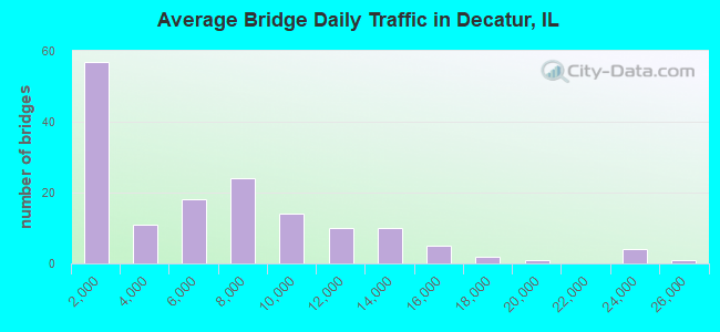
- 927,425Total average daily traffic
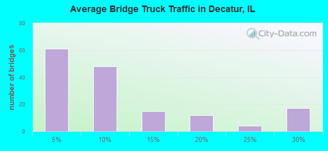
- 94,922Total average daily truck traffic
- National Bridge Inventory (NBI) Registered Bridges for Decatur
- No street view available for this location
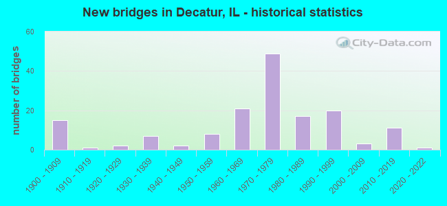
- New bridges - historical statistics
- 151900-1909
- 11910-1919
- 21920-1929
- 71930-1939
- 21940-1949
- 81950-1959
- 211960-1969
- 491970-1979
- 171980-1989
- 201990-1999
- 32000-2009
- 112010-2019
- 12020-2022
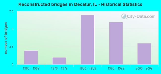
- Reconstructed bridges - Historical Statistics
- 21960-1969
- 11970-1979
- 71980-1989
- 61990-1999
- 32000-2009
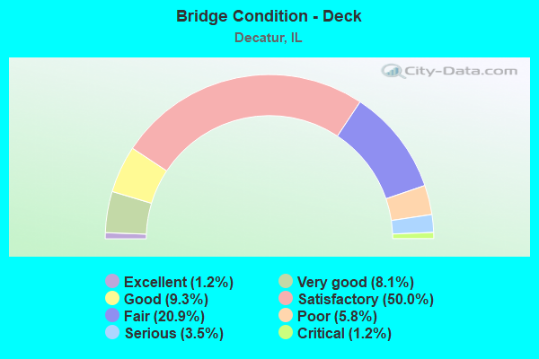
- Bridge Condition - Deck
- 1.2%Excellent
- 8.1%Very good
- 9.3%Good
- 50.0%Satisfactory
- 20.9%Fair
- 5.8%Poor
- 3.5%Serious
- 1.2%Critical
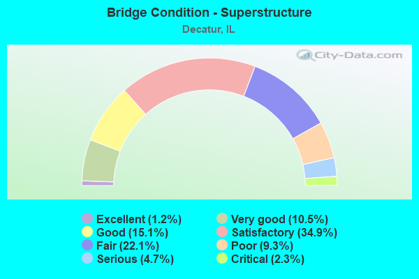
- Bridge Condition - Superstructure
- 1.2%Excellent
- 10.5%Very good
- 15.1%Good
- 34.9%Satisfactory
- 22.1%Fair
- 9.3%Poor
- 4.7%Serious
- 2.3%Critical
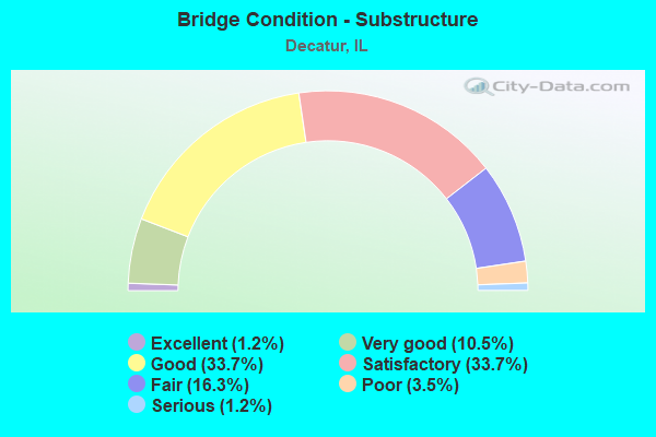
- Bridge Condition - Substructure
- 1.2%Excellent
- 10.5%Very good
- 33.7%Good
- 33.7%Satisfactory
- 16.3%Fair
- 3.5%Poor
- 1.2%Serious
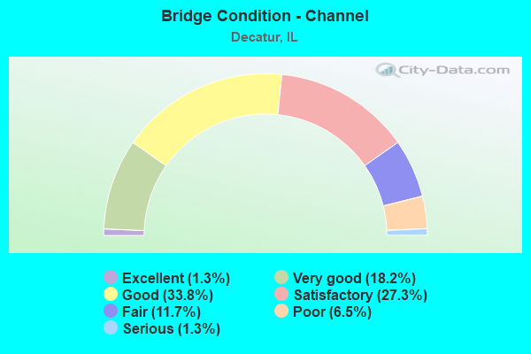
- Bridge Condition - Channel
- 1.3%Excellent
- 18.2%Very good
- 33.8%Good
- 27.3%Satisfactory
- 11.7%Fair
- 6.5%Poor
- 1.3%Serious
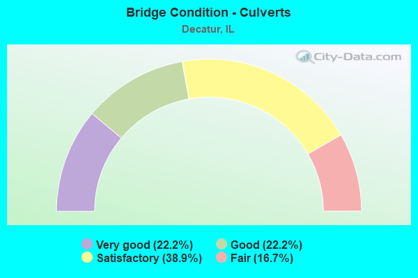
- Bridge Condition - Culverts
- 22.2%Very good
- 22.2%Good
- 38.9%Satisfactory
- 16.7%Fair
Find on map >> Show street view
Structure Number: 580101, Location: 1 MI S OF DECATUR (Lat: 39.785328, Lng: -88.978142), Route carried "under" structure: Other road , Year Built: 1976, Structure Length: 0. m, Average Daily Traffic: 6,350 (year 2020), Truck Traffic: 10%, Features Intersected: FA 710/IC RR (BS 51), Facility Carried by Structure: FAP 322(NB) (US 5
Minimum Vertical Clearance: 8.66m (28.41ft), Kilometerpoint: 14.323, Lanes on structure: 2, Lanes under structure: 4, Material/Design: Steel continuous, Design/Construction: Stringer/Multi-beam, Length of Maximum Span: 38.4m (126.0ft)
Find on map >> Show street view
Structure Number: 580102, Location: 1 MI S OF DECATUR (Lat: 39.785553, Lng: -88.978083), Route carried "under" structure: Other road , Year Built: 1976, Structure Length: 0. m, Average Daily Traffic: 6,350 (year 2020), Truck Traffic: 10%, Features Intersected: FA 710/IC RR (BS 51), Facility Carried by Structure: FAP 322(SB) (US 51
Minimum Vertical Clearance: 8.59m (28.18ft), Kilometerpoint: 14.307, Lanes on structure: 2, Lanes under structure: 4, Material/Design: Steel continuous, Design/Construction: Stringer/Multi-beam, Length of Maximum Span: 38.4m (126.0ft)
Find on map >> Show street view
Structure Number: 580104, Location: 1 MI S OF DECATUR (Lat: 39.785844, Lng: -88.980989), Route carried "under" structure: Other road , Year Built: 1976, Structure Length: 0. m, Average Daily Traffic: 275 (year 2020), Truck Traffic: 4%, Features Intersected: FAU 7426(TAYLOR RD), Facility Carried by Structure: FAP 322(NB) (US 5
Minimum Vertical Clearance: 4.57m (14.99ft), Kilometerpoint: 4.055, Lanes on structure: 2, Lanes under structure: 2, Material/Design: Prestressed concrete, Design/Construction: Stringer/Multi-beam, Length of Maximum Span: 26.9m (88.3ft)
Find on map >> Show street view
Structure Number: 580105, Location: 1 MI S OF DECATUR (Lat: 39.785547, Lng: -88.980981), Route carried "under" structure: Other road , Year Built: 1976, Structure Length: 0. m, Average Daily Traffic: 275 (year 2020), Truck Traffic: 4%, Features Intersected: FAU 7426(TAYLOR RD), Facility Carried by Structure: FAP 322(SB) (US 5
Minimum Vertical Clearance: 4.60m (15.09ft), Kilometerpoint: 4.088, Lanes on structure: 2, Lanes under structure: 2, Material/Design: Prestressed concrete, Design/Construction: Stringer/Multi-beam, Length of Maximum Span: 26.9m (88.3ft)
Find on map >> Show street view
Structure Number: 580108, Location: .5 MI SW OF DECATUR (Lat: 39.799903, Lng: -89.008189), Route carried "under" structure: State highway 48, Year Built: 1978, Structure Length: 0. m, Average Daily Traffic: 4,250 (year 2021), Truck Traffic: 12%, Features Intersected: IL 48 & N&S RR, Facility Carried by Structure: FAP 322(SB)(US 51)
Minimum Vertical Clearance: 7.09m (23.26ft), Kilometerpoint: 78.840, Lanes on structure: 2, Lanes under structure: 4, Material/Design: Steel continuous, Design/Construction: Stringer/Multi-beam, Length of Maximum Span: 37.4m (122.7ft)
Find on map >> Show street view
Structure Number: 580109, Location: .5 MI SW OF DECATUR (Lat: 39.800158, Lng: -89.007897), Route carried "under" structure: State highway 48, Year Built: 1978, Structure Length: 0. m, Average Daily Traffic: 4,250 (year 2021), Truck Traffic: 12%, Features Intersected: IL 48 & N&S RR, Facility Carried by Structure: FAP 322(NB)(US 51)
Minimum Vertical Clearance: 7.06m (23.16ft), Kilometerpoint: 78.872, Lanes on structure: 2, Lanes under structure: 4, Material/Design: Steel continuous, Design/Construction: Stringer/Multi-beam, Length of Maximum Span: 37.4m (122.7ft)
Find on map >> Show street view
Structure Number: 580121, Location: FAIRVIEW(DECATUR) (Lat: 39.847319, Lng: -88.977519), Route carried "under" structure: State highway 48, Year Built: 1992, Structure Length: 0. m, Average Daily Traffic: 12,500 (year 2021), Truck Traffic: 4%, Features Intersected: FAU 7429(IL 48), Facility Carried by Structure: N&S RR
Minimum Vertical Clearance: 4.39m (14.40ft), Kilometerpoint: 85.406, Lanes under structure: 4, Material/Design: Steel, Length of Maximum Span: 20.7m (67.9ft)
Find on map >> Show street view
Structure Number: 580122, Location: 2 MI S OF ELWIN (Lat: 39.765639, Lng: -88.980675), Route carried "under" structure: US 51, Year Built: 1994, Structure Length: 0. m, Average Daily Traffic: 2,600 (year 2021), Truck Traffic: 18%, Features Intersected: FAP 322(US 51), Facility Carried by Structure: FAP 710(NB BS RT 5
Minimum Vertical Clearance: 5.94m (19.49ft), Kilometerpoint: 333.640, Lanes on structure: 2, Lanes under structure: 4, Material/Design: Prestressed concrete continuous, Design/Construction: Stringer/Multi-beam, Length of Maximum Span: 32.0m (105.0ft)
Find on map >> Show street view
Structure Number: 580123, Location: 2 MI S OF ELWIN (Lat: 39.765761, Lng: -88.980439), Route carried "under" structure: US 51, Year Built: 1994, Structure Length: 0. m, Average Daily Traffic: 2,600 (year 2021), Truck Traffic: 18%, Features Intersected: FAP 322(US 51), Facility Carried by Structure: TR 114B(RILEY RD)
Minimum Vertical Clearance: 5.61m (18.41ft), Kilometerpoint: 333.672, Lanes on structure: 2, Lanes under structure: 4, Material/Design: Prestressed concrete continuous, Design/Construction: Stringer/Multi-beam, Length of Maximum Span: 32.0m (105.0ft)
Find on map >> Show street view
Structure Number: 580124, Location: .5 MI E OF ELWIN (Lat: 39.777603, Lng: -88.969292), Route carried "under" structure: US 51, Year Built: 1994, Structure Length: 0. m, Average Daily Traffic: 2,600 (year 2021), Truck Traffic: 18%, Features Intersected: FAP 322(US 51), Facility Carried by Structure: FAS 552(CH 30)
Minimum Vertical Clearance: 5.23m (17.16ft), Kilometerpoint: 335.507, Lanes on structure: 2, Lanes under structure: 4, Material/Design: Prestressed concrete continuous, Design/Construction: Stringer/Multi-beam, Length of Maximum Span: 30.8m (101.0ft)
Find on map >> Show street view
Structure Number: 580127, Location: IN DECATUR (Lat: 39.846875, Lng: -88.977511), Route carried "under" structure: State highway 48, Year Built: 1998, Structure Length: 0. m, Average Daily Traffic: 12,500 (year 2021), Truck Traffic: 4%, Features Intersected: FAU 7429(IL 48), Facility Carried by Structure: FAP 323(US 36)
Minimum Vertical Clearance: 4.39m (14.40ft), Kilometerpoint: 85.357, Lanes on structure: 4, Lanes under structure: 4, Material/Design: Steel, Design/Construction: Stringer/Multi-beam, Length of Maximum Span: 22.6m (74.1ft)
Find on map >> Show street view
Structure Number: 580136, Location: S EDGE FORSYTH (Lat: 39.908144, Lng: -88.955361), Route carried "under" structure: Interstate 72, Year Built: 2011, Structure Length: 0. m, Average Daily Traffic: 12,000 (year 2021), Truck Traffic: 29%, Features Intersected: I-72, Facility Carried by Structure: FAP 322(US 51)
Minimum Vertical Clearance: 5.13m (16.83ft), Kilometerpoint: 227.668, Lanes on structure: 4, Lanes under structure: 4, Material/Design: Steel continuous, Design/Construction: Stringer/Multi-beam, Length of Maximum Span: 38.3m (125.7ft)
Find on map >> Show street view
Structure Number: 583013, Location: 0.3 MI S OF FAU 7369 (Lat: 39.859094, Lng: -88.897969), Route carried "under" structure: Other road , Year Built: 1932, Structure Length: 0. m, Average Daily Traffic: 8,850 (year 2020), Truck Traffic: 9%, Features Intersected: BRUSH COLLEGE(U 7448, Facility Carried by Structure: N&W RR
Minimum Vertical Clearance: 4.60m (15.09ft), Kilometerpoint: 4.876, Lanes under structure: 2, Material/Design: Steel, Design/Construction: Stringer/Multi-beam, Length of Maximum Span: 8.3m (27.2ft)
Find on map >> Show street view
Structure Number: 583014, Location: 0.33 M S OF FAU 7369 (Lat: 39.858661, Lng: -88.897961), Route carried "under" structure: Other road , Year Built: 1932, Structure Length: 0. m, Average Daily Traffic: 8,850 (year 2020), Truck Traffic: 9%, Features Intersected: BRUSH COLLEGE(U 7448, Facility Carried by Structure: N&W RR
Minimum Vertical Clearance: 4.42m (14.50ft), Kilometerpoint: 4.924, Lanes under structure: 2, Material/Design: Steel, Design/Construction: Stringer/Multi-beam, Length of Maximum Span: 8.1m (26.6ft)
Find on map >> Show street view
Structure Number: 586001, Location: 1.54 MI E OF US 51 (Lat: 39.862811, Lng: -88.926789), Route carried "under" structure: State highway 121, Year Built: 1965, Structure Length: 0. m, Average Daily Traffic: 14,600 (year 2021), Truck Traffic: 10%, Features Intersected: IL 121(FAP 320), Facility Carried by Structure: GARFIELD AV(FAU 73
Minimum Vertical Clearance: 4.55m (14.93ft), Kilometerpoint: 115.580, Lanes on structure: 4, Lanes under structure: 4, Material/Design: Steel, Design/Construction: Stringer/Multi-beam, Length of Maximum Span: 20.4m (66.9ft)
Find on map >> Show street view
Structure Number: 586004, Location: 0.1 MI N OF US 36 (Lat: 39.847389, Lng: -88.963647), Route carried "under" structure: Other road , Year Built: 1900, Structure Length: 0. m, Average Daily Traffic: 7,600 (year 2020), Truck Traffic: 3%, Features Intersected: MONROE ST(FAU 7432), Facility Carried by Structure: N&W RR
Minimum Vertical Clearance: 4.27m (14.01ft), Kilometerpoint: 6.502, Lanes under structure: 4, Material/Design: Steel, Design/Construction: Stringer/Multi-beam, Length of Maximum Span: 17.7m (58.1ft)
Find on map >> Show street view
Structure Number: 589004, Location: 1 BLOCK N US 36 (Lat: 39.847853, Lng: -88.940564), Route carried "under" structure: Other road , Year Built: 1900, Structure Length: 0. m, Average Daily Traffic: 8,100 (year 2020), Truck Traffic: 2%, Features Intersected: JASPER ST(FAU 7439), Facility Carried by Structure: RR SWITCH YARDS
Minimum Vertical Clearance: 3.40m (11.15ft), Kilometerpoint: 3.267, Lanes under structure: 2, Material/Design: Steel continuous, Design/Construction: Box Beam or Girders - Multiple, Length of Maximum Span: 12.5m (41.0ft)
Find on map >> Show street view
Structure Number: 589005, Location: 1 BLOCK N US 36 (Lat: 39.847375, Lng: -88.940550), Route carried "under" structure: Other road , Year Built: 1900, Structure Length: 0. m, Average Daily Traffic: 8,100 (year 2020), Truck Traffic: 2%, Features Intersected: JASPER ST(FAU 7439), Facility Carried by Structure: RR SWITCH YARDS
Minimum Vertical Clearance: 3.40m (11.15ft), Kilometerpoint: 3.315, Lanes under structure: 2, Material/Design: Concrete, Design/Construction: Slab, Length of Maximum Span: 12.5m (41.0ft)
Find on map >> Show street view
Structure Number: 589006, Location: SW DECATUR (Lat: 39.841081, Lng: -88.973114), Route carried "under" structure: Other road , Year Built: 1900, Structure Length: 0. m, Average Daily Traffic: 3,650 (year 2020), Truck Traffic: 3%, Features Intersected: MAIN ST(FAU 7386), Facility Carried by Structure: N&S RR
Minimum Vertical Clearance: 4.39m (14.40ft), Kilometerpoint: 4.973, Lanes under structure: 2, Material/Design: Steel continuous, Design/Construction: Girder and Floorbeam System, Length of Maximum Span: 16.5m (54.1ft)
Find on map >> Show street view
Structure Number: 5899, Location: W OF PINE ST (Lat: 39.845600, Lng: -88.967511), Route carried "under" structure: US 36, Year Built: 1937, Structure Length: 0. m, Average Daily Traffic: 12,200 (year 2021), Truck Traffic: 6%, Features Intersected: US 36(FAP 323), Facility Carried by Structure: N&S RR
Minimum Vertical Clearance: 4.50m (14.76ft), Kilometerpoint: 222.856, Lanes under structure: 2, Material/Design: Steel, Design/Construction: Girder and Floorbeam System, Length of Maximum Span: 24.1m (79.1ft)
Find on map >> Show street view
Structure Number: 589904, Location: W LAKE SHORE BR (Lat: 39.828789, Lng: -88.958711), Route carried "under" structure: City street , Year Built: 1900, Structure Length: 0. m, Average Daily Traffic: 100 (year 2020), Truck Traffic: 3%, Features Intersected: LINCOLN PKRD(U 7392), Facility Carried by Structure: IC RR
Minimum Vertical Clearance: 6.12m (20.08ft), Kilometerpoint: 0.016, Lanes under structure: 2, Material/Design: Steel, Design/Construction: Stringer/Multi-beam, Length of Maximum Span: 29.9m (98.1ft)
Find on map >> Show street view
Structure Number: 589905, Location: E OF BROADWAY (Lat: 39.842697, Lng: -88.948317), Route carried "under" structure: Other road , Year Built: 1915, Structure Length: 0. m, Average Daily Traffic: 1,650 (year 2020), Truck Traffic: 5%, Features Intersected: PRAIRIE ST(FAU 7385), Facility Carried by Structure: IC RR
Minimum Vertical Clearance: 4.11m (13.48ft), Kilometerpoint: 0.418, Lanes under structure: 2, Material/Design: Steel, Design/Construction: Stringer/Multi-beam, Length of Maximum Span: 7.6m (24.9ft)
Find on map >> Show street view
Structure Number: 589906, Location: IN DECATUR (Lat: 39.834486, Lng: -88.976003), Route carried "under" structure: City street , Year Built: 1900, Structure Length: 0. m, Average Daily Traffic: 275 (year 2020), Truck Traffic: 1%, Features Intersected: SUNSET AVE(MS 2480B), Facility Carried by Structure: N&S RR
Minimum Vertical Clearance: 10.67m (35.01ft), Kilometerpoint: 0.097, Lanes under structure: 2, Material/Design: Steel, Design/Construction: Stringer/Multi-beam, Length of Maximum Span: 14.0m (45.9ft)
Find on map >> Show street view
Structure Number: 589907, Location: EAST OF ILL 48 (Lat: 39.836972, Lng: -88.975786), Route carried "under" structure: City street , Year Built: 1900, Structure Length: 0. m, Average Daily Traffic: 450 (year 2020), Truck Traffic: 1%, Features Intersected: FOREST AVE(MS 2450A), Facility Carried by Structure: N&S RR
Minimum Vertical Clearance: 3.48m (11.42ft), Kilometerpoint: 0.129, Lanes under structure: 2, Material/Design: Concrete, Length of Maximum Span: 5.2m (17.1ft)
Find on map >> Show street view
Structure Number: 589909, Location: AT W MAIN (Lat: 39.841631, Lng: -88.972750), Route carried "under" structure: Other road , Year Built: 1900, Structure Length: 0. m, Average Daily Traffic: 5,000 (year 2020), Truck Traffic: 3%, Features Intersected: OAKLAND AVE(FAU 7430, Facility Carried by Structure: N&W RR
Minimum Vertical Clearance: 4.19m (13.75ft), Kilometerpoint: 1.593, Lanes under structure: 2, Material/Design: Steel, Design/Construction: Girder and Floorbeam System, Length of Maximum Span: 16.5m (54.1ft)
Find on map >> Show street view
Structure Number: 58991, Location: S SIDE OF DECATUR (Lat: 39.846919, Lng: -88.968261), Route carried "under" structure: City street , Year Built: 1900, Structure Length: 0. m, Average Daily Traffic: 1,800 (year 2020), Truck Traffic: 6%, Features Intersected: VAN DYKE ST(MS 6750E, Facility Carried by Structure: N&W RR
Minimum Vertical Clearance: 3.78m (12.40ft), Kilometerpoint: 0.869, Lanes under structure: 2, Material/Design: Steel, Design/Construction: Girder and Floorbeam System, Length of Maximum Span: 13.7m (44.9ft)
Find on map >> Show street view
Structure Number: 589912, Location: 3 BLKS E BROADWAY (Lat: 39.855058, Lng: -88.945508), Route carried "under" structure: Other road , Year Built: 1900, Structure Length: 0. m, Average Daily Traffic: 8,300 (year 2020), Truck Traffic: 3%, Features Intersected: GRAND AVE(FAU 7374), Facility Carried by Structure: IC RR
Minimum Vertical Clearance: 4.32m (14.17ft), Kilometerpoint: 7.451, Lanes under structure: 4, Material/Design: Steel, Design/Construction: Girder and Floorbeam System, Length of Maximum Span: 18.0m (59.1ft)
Find on map >> Show street view
Structure Number: 589913, Location: 3 BLKS W OF JASPER (Lat: 39.852911, Lng: -88.946414), Route carried "under" structure: Other road , Year Built: 1900, Structure Length: 0. m, Average Daily Traffic: 900 (year 2020), Truck Traffic: 1%, Features Intersected: CONDIT ST(FAU 7375), Facility Carried by Structure: IC RR
Minimum Vertical Clearance: 4.27m (14.01ft), Kilometerpoint: 0.821, Lanes under structure: 2, Material/Design: Concrete, Design/Construction: Girder and Floorbeam System, Length of Maximum Span: 13.4m (44.0ft)
Find on map >> Show street view
Structure Number: 589914, Location: N OF NELSON PK RD (Lat: 39.836242, Lng: -88.913225), Route carried "under" structure: Other road , Year Built: 1928, Structure Length: 0. m, Average Daily Traffic: 200 (year 2021), Truck Traffic: 5%, Features Intersected: LAKE SHORE DR(U 7390, Facility Carried by Structure: CSX RR
Minimum Vertical Clearance: 3.43m (11.25ft), Kilometerpoint: 3.573, Lanes under structure: 2, Material/Design: Concrete, Design/Construction: Slab, Length of Maximum Span: 11.9m (39.0ft)
Find on map >> Show street view
Structure Number: 589915, Location: SW CL OF DECATUR (Lat: 39.823931, Lng: -88.961011), Route carried "under" structure: Other road , Year Built: 1900, Structure Length: 0. m, Average Daily Traffic: 150 (year 2020), Truck Traffic: 5%, Features Intersected: FAP 714 FR 0.01, Facility Carried by Structure: IC RR
Minimum Vertical Clearance: 5.08m (16.67ft), Kilometerpoint: 0.225, Lanes under structure: 2, Material/Design: Wood or Timber, Length of Maximum Span: 13.7m (44.9ft)