Bridge Statistics for Delray Beach, Florida (FL)
Condition, Traffic, Stress, Structural Evaluation, Project Costs
- National Bridge Inventory (NBI) Statistics
- 63Number of bridges
- 761ft / 232mTotal length
- $180,000Total costs
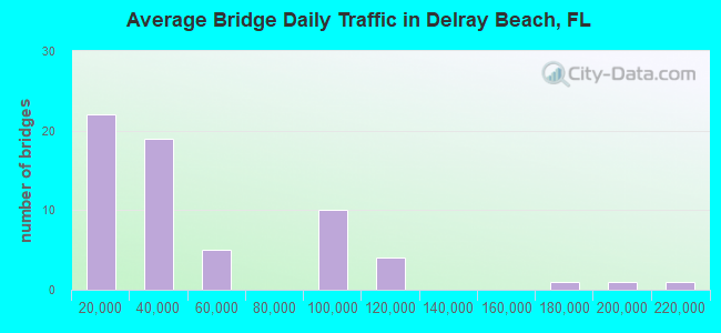
- 2,884,467Total average daily traffic
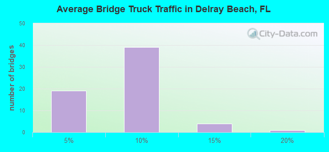
- 203,028Total average daily truck traffic
- National Bridge Inventory (NBI) Registered Bridges for Delray Beach
- No street view available for this location
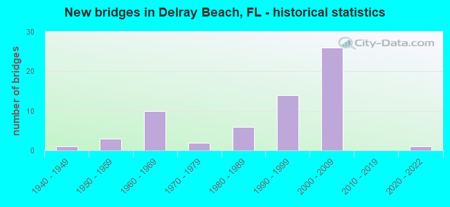
- New bridges - historical statistics
- 11940-1949
- 31950-1959
- 101960-1969
- 21970-1979
- 61980-1989
- 141990-1999
- 262000-2009
- 12020-2022
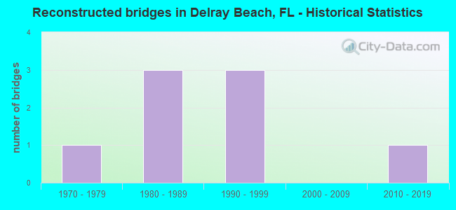
- Reconstructed bridges - Historical Statistics
- 11970-1979
- 31980-1989
- 31990-1999
- 02000-2009
- 12010-2019
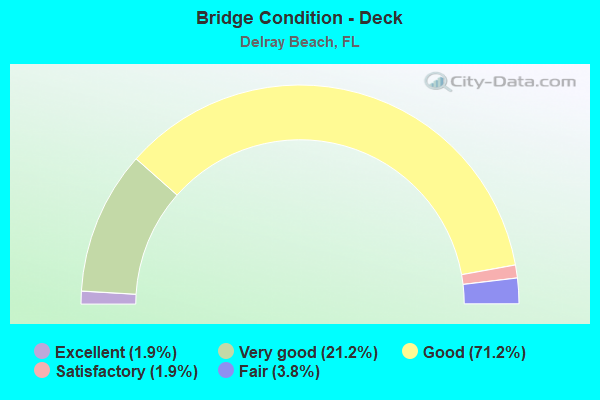
- Bridge Condition - Deck
- 1.9%Excellent
- 21.2%Very good
- 71.2%Good
- 1.9%Satisfactory
- 3.8%Fair
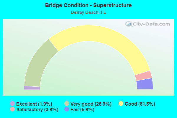
- Bridge Condition - Superstructure
- 1.9%Excellent
- 26.9%Very good
- 61.5%Good
- 3.8%Satisfactory
- 5.8%Fair
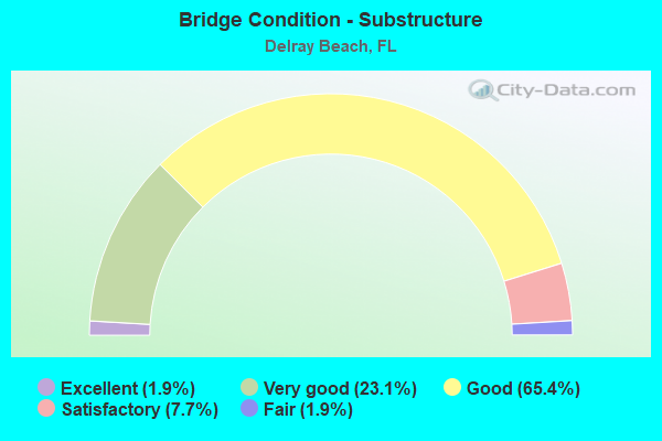
- Bridge Condition - Substructure
- 1.9%Excellent
- 23.1%Very good
- 65.4%Good
- 7.7%Satisfactory
- 1.9%Fair
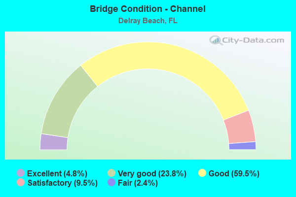
- Bridge Condition - Channel
- 4.8%Excellent
- 23.8%Very good
- 59.5%Good
- 9.5%Satisfactory
- 2.4%Fair
Find on map >> Show street view
Structure Number: 934939, Location: 1.9Mi S OF WOOLBRIGHT (Lat: 26.483922, Lng: -80.147061), Route carried "on" structure: County highway , Year Built: 1994, Status: Open, Structure Length: 2.74m (8.99ft), Average Daily Traffic: 24,000 (year 2020), Truck Traffic: 2%, Average Future Daily Traffic: 41,640 (year 2042), Design Load: HS 20+Mod, Features Intersected: LWDD L-30 CANAL, Facility Carried by Structure: JOG ROAD NB
Minimum Vertical Clearance: 30+ m (98+ ft), Kilometerpoint: 12.785, Lanes on structure: 3, Owner: County Highway Agency, Approaching Roadway Width: 12.2m (40.0ft), Material/Design: Prestressed concrete, Design/Construction: Stringer/Multi-beam, Number Of Spans In Main Unit: 1, Length of Maximum Span: 27.4m (89.9ft), Curb or Sidewalk Widths: Left: 0.0m, Right: 2.0m (6.6ft), Curb-To-Curb Width: 13.3m (43.6ft), Out-to-Out Width: 16.2m (53.1ft)
Condition: Deck: Very good, Superstructure: Very good, Substructure: Very good, Channel: Very good, Inventory Rating: 63.6 metric tons, Method Used To Determine Inventory Rating: Load Factor (LF), Structural Evaluation: Equal to present desirable criteria, Deck Geometry: Somewhat better than minimum adequacy, Waterway Adequacy: Equal to present desirable criteria, Approach Roadway Alignment: Equal to present desirable criteria, Designated Inspection Frequency: Every 24 months, Inspection Date: June 2020, Deck Structure Type: Concrete Cast-file-Place
Find on map >> Show street view
Structure Number: 934952, Location: 1MI S OF LINTON BLVD (Lat: 26.424169, Lng: -80.146422), Route carried "on" structure: County highway , Year Built: 1997, Status: Open, Structure Length: 2.74m (8.99ft), Average Daily Traffic: 33,000 (year 2020), Truck Traffic: 2%, Average Future Daily Traffic: 57,255 (year 2042), Design Load: HS 20, Features Intersected: L-38 CANAL, Facility Carried by Structure: JOG RD NB
Minimum Vertical Clearance: 30+ m (98+ ft), Kilometerpoint: 6.167, Lanes on structure: 3, Base Highway Network: Yes, Owner: County Highway Agency, Approaching Roadway Width: 12.6m (41.3ft), Material/Design: Prestressed concrete, Design/Construction: Stringer/Multi-beam, Number Of Spans In Main Unit: 1, Length of Maximum Span: 27.4m (89.9ft), Curb or Sidewalk Widths: Left: 0.0m, Right: 2.0m (6.6ft), Curb-To-Curb Width: 13.2m (43.3ft), Out-to-Out Width: 16.2m (53.1ft)
Condition: Deck: Very good, Superstructure: Very good, Substructure: Very good, Channel: Very good, Operating Rating: 64.0 metric tons, Method Used To Determine Operating Rating: Load Factor (LF), Inventory Rating: 55.9 metric tons, Method Used To Determine Inventory Rating: Load Factor (LF), Structural Evaluation: Equal to present desirable criteria, Deck Geometry: Somewhat better than minimum adequacy, Waterway Adequacy: Equal to present desirable criteria, Approach Roadway Alignment: Equal to present desirable criteria, Designated Inspection Frequency: Every 24 months, Inspection Date: July 2020, Deck Structure Type: Concrete Cast-file-Place
Find on map >> Show street view
Structure Number: 934958, Location: 2.0 Miles N of SR-806 (Lat: 26.483831, Lng: -80.163561), Route carried "on" structure: County highway , Year Built: 2002, Status: Open, Structure Length: 2.84m (9.32ft), Average Daily Traffic: 12,533 (year 2021), Truck Traffic: 2%, Average Future Daily Traffic: 15,040 (year 2042), Design Load: HS 20, Features Intersected: LWDD L30 Canal, Facility Carried by Structure: Hagen Ranch Road
Minimum Vertical Clearance: 30+ m (98+ ft), Kilometerpoint: 3.339, Lanes on structure: 4, Owner: County Highway Agency, Approaching Roadway Width: 19.4m (63.6ft), Skew: 1 degrees, Material/Design: Prestressed concrete, Design/Construction: Slab, Number Of Spans In Main Unit: 3, Length of Maximum Span: 9.5m (31.2ft), Curb or Sidewalk Widths: Left: 2.0m (6.6ft), Right: 2.0m (6.6ft), Curb-To-Curb Width: 19.7m (64.6ft), Out-to-Out Width: 24.2m (79.4ft)
Condition: Deck: Good, Superstructure: Good, Substructure: Good, Channel: Good, Inventory Rating: 55.2 metric tons, Method Used To Determine Inventory Rating: Load Factor (LF), Structural Evaluation: Better than present minimum criteria, Deck Geometry: Better than present minimum criteria, Waterway Adequacy: Better than present minimum criteria, Approach Roadway Alignment: Better than present minimum criteria, Designated Inspection Frequency: Every 24 months, Underwater Inspection Frequency: Every 24 months, Inspection Date: May 2021, Underwater Inspection Date: May 2021, Deck Structure Type: Concrete Precast Panels, Wearing Surface/Protective System: Wearing Surface: Bituminous
Find on map >> Show street view
Structure Number: 934963, Location: 1Mi E of CR809/Military T (Lat: 26.473072, Lng: -80.106100), Route carried "on" structure: City street , Year Built: 2002, Status: Open, Structure Length: 1.11m (3.64ft), Average Daily Traffic: 2,700 (year 2020), Truck Traffic: 2%, Average Future Daily Traffic: 46,846 (year 2042), Design Load: HS 25 or greater, Features Intersected: C-3 Canal, Facility Carried by Structure: Lake Ida Road
Minimum Vertical Clearance: 30+ m (98+ ft), Kilometerpoint: 1.640, Lanes on structure: 5, Owner: County Highway Agency, Approaching Roadway Width: 17.1m (56.1ft), Skew: 20 degrees, Material/Design: Prestressed concrete, Design/Construction: Slab, Number Of Spans In Main Unit: 1, Length of Maximum Span: 11.1m (36.4ft), Curb or Sidewalk Widths: Left: 2.0m (6.6ft), Right: 2.0m (6.6ft), Curb-To-Curb Width: 20.9m (68.6ft), Out-to-Out Width: 28.0m (91.9ft)
Condition: Deck: Good, Superstructure: Good, Substructure: Good, Channel: Good, Operating Rating: 46.1 metric tons, Method Used To Determine Operating Rating: Load Factor (LF), Inventory Rating: 27.7 metric tons, Method Used To Determine Inventory Rating: Load Factor (LF), Structural Evaluation: Equal to present minimum criteria, Deck Geometry: Somewhat better than minimum adequacy, Waterway Adequacy: Equal to present desirable criteria, Approach Roadway Alignment: Equal to present desirable criteria, Designated Inspection Frequency: Every 24 months, Inspection Date: November 2020, Deck Structure Type: Concrete Precast Panels, Wearing Surface/Protective System: Wearing Surface: Bituminous
Find on map >> Show street view
Structure Number: 934964, Location: 1.1 MI E OF JOG ROAD (Lat: 26.471053, Lng: -80.130722), Route carried "on" structure: County highway , Year Built: 1996, Status: Open, Structure Length: 1.28m (4.20ft), Average Daily Traffic: 111,000 (year 2020), Truck Traffic: 5%, Average Future Daily Traffic: 192,590 (year 2042), Design Load: HS 20+Mod, Features Intersected: E3 CANAL, Facility Carried by Structure: LAKE IDA ROAD
Minimum Vertical Clearance: 30+ m (98+ ft), Kilometerpoint: 3.314, Lanes on structure: 3, Owner: County Highway Agency, Approaching Roadway Width: 13.1m (43.0ft), Skew: 1 degrees, Material/Design: Prestressed concrete, Design/Construction: Slab, Number Of Spans In Main Unit: 1, Length of Maximum Span: 12.8m (42.0ft), Curb or Sidewalk Widths: Left: 1.8m (5.9ft), Right: 1.4m (4.6ft), Curb-To-Curb Width: 19.7m (64.6ft), Out-to-Out Width: 25.0m (82.0ft)
Condition: Deck: Good, Superstructure: Good, Substructure: Good, Channel: Good, Operating Rating: 67.9 metric tons, Method Used To Determine Operating Rating: Load Factor (LF), Inventory Rating: 40.7 metric tons, Method Used To Determine Inventory Rating: Load Factor (LF), Structural Evaluation: Better than present minimum criteria, Deck Geometry: Superior to present desirable criteria, Waterway Adequacy: Equal to present desirable criteria, Approach Roadway Alignment: Better than present minimum criteria, Designated Inspection Frequency: Every 24 months, Inspection Date: October 2020, Deck Structure Type: Concrete Precast Panels, Wearing Surface/Protective System: Wearing Surface: Bituminous
Find on map >> Show street view
Structure Number: 934986, Location: 0.5 Mile West of I-95 (Lat: 26.439567, Lng: -80.097447), Route carried "on" structure: County highway 782, Year Built: 2003, Status: Open, Structure Length: 3.67m (12.04ft), Average Daily Traffic: 34,000 (year 2020), Truck Traffic: 7%, Average Future Daily Traffic: 58,990 (year 2042), Features Intersected: LWDD E-4 Canal, Facility Carried by Structure: Linton Blvd.
Minimum Vertical Clearance: 30+ m (98+ ft), Kilometerpoint: 2.453, Lanes on structure: 6, Owner: County Highway Agency, Approaching Roadway Width: 22.8m (74.8ft), Skew: 20 degrees, Material/Design: Prestressed concrete, Design/Construction: Slab, Number Of Spans In Main Unit: 3, Length of Maximum Span: 13.4m (44.0ft), Curb or Sidewalk Widths: Left: 2.0m (6.6ft), Right: 0.0m, Curb-To-Curb Width: 22.8m (74.8ft), Out-to-Out Width: 30.4m (99.7ft)
Condition: Deck: Very good, Superstructure: Very good, Substructure: Good, Channel: Very good, Operating Rating: 81.4 metric tons, Method Used To Determine Operating Rating: Load Factor (LF), Inventory Rating: 48.8 metric tons, Method Used To Determine Inventory Rating: Load Factor (LF), Structural Evaluation: Better than present minimum criteria, Deck Geometry: Meets minimum limits, Waterway Adequacy: Equal to present desirable criteria, Approach Roadway Alignment: Equal to present desirable criteria, Designated Inspection Frequency: Every 24 months, Underwater Inspection Frequency: Every 24 months, Inspection Date: May 2020, Underwater Inspection Date: May 2020, Deck Structure Type: Concrete Precast Panels, Wearing Surface/Protective System: Wearing Surface: Bituminous
Find on map >> Show street view
Structure Number: 935501, Location: .2MI S of LINDELL BLVD (Lat: 26.424608, Lng: -80.081514), Route carried "on" structure: City street , Year Built: 1964, Status: Posted for load-capacity, Structure Length: 5.33m (17.49ft), Average Daily Traffic: 8,100 (year 2020), Truck Traffic: 7%, Average Future Daily Traffic: 14,054 (year 2042), Design Load: HS 20, Features Intersected: SFWMD C-15 CANAL, Facility Carried by Structure: BRANT DR/CARL BOTT
Minimum Vertical Clearance: 30+ m (98+ ft), Kilometerpoint: 0.792, Lanes on structure: 2, Owner: City or Municipal Highway Agency, Approaching Roadway Width: 7.3m (24.0ft), Material/Design: Prestressed concrete, Design/Construction: Slab, Number Of Spans In Main Unit: 5, Length of Maximum Span: 10.7m (35.1ft), Curb or Sidewalk Widths: Left: 0.3m (1.0ft), Right: 1.2m (3.9ft), Curb-To-Curb Width: 7.3m (24.0ft), Out-to-Out Width: 9.4m (30.8ft)
Condition: Deck: Good, Superstructure: Fair, Substructure: Good, Channel: Fair, Inventory Rating: 57.7 metric tons, Method Used To Determine Inventory Rating: Allowable Stress (AS), Structural Evaluation: Somewhat better than minimum adequacy, Deck Geometry: High priority of replacement, Waterway Adequacy: Better than present minimum criteria, Approach Roadway Alignment: Equal to present minimum criteria, Designated Inspection Frequency: Every 24 months, Underwater Inspection Frequency: Every 24 months, Inspection Date: September 2020, Underwater Inspection Date: September 2020, Deck Structure Type: Concrete Precast Panels, Wearing Surface/Protective System: Wearing Surface: Bituminous
Find on map >> Show street view
Structure Number: 935502, Location: 0.2 MI W OF LINDELL BLVD (Lat: 26.429381, Lng: -80.084342), Route carried "on" structure: City street , Year Built: 1969, Status: Open, Structure Length: 0.79m (2.59ft), Average Daily Traffic: 3,000 (year 2020), Truck Traffic: 5%, Average Future Daily Traffic: 3,600 (year 2042), Design Load: H 15, Features Intersected: HUNGERFORD CANAL, Facility Carried by Structure: AUDUBON BLVD.
Minimum Vertical Clearance: 30+ m (98+ ft), Kilometerpoint: 0.000, Lanes on structure: 2, Owner: City or Municipal Highway Agency, Approaching Roadway Width: 7.0m (23.0ft), Material/Design: Concrete, Design/Construction: Slab, Number Of Spans In Main Unit: 1, Length of Maximum Span: 7.9m (25.9ft), Curb or Sidewalk Widths: Left: 1.2m (3.9ft), Right: 1.2m (3.9ft), Curb-To-Curb Width: 8.6m (28.2ft), Out-to-Out Width: 11.4m (37.4ft)
Condition: Deck: Good, Superstructure: Good, Substructure: Good, Channel: Good, Operating Rating: 46.9 metric tons, Method Used To Determine Operating Rating: Load Factor (LF), Inventory Rating: 28.1 metric tons, Method Used To Determine Inventory Rating: Load Factor (LF), Structural Evaluation: Better than present minimum criteria, Deck Geometry: Meets minimum limits, Waterway Adequacy: Equal to present minimum criteria, Approach Roadway Alignment: Better than present minimum criteria, Designated Inspection Frequency: Every 24 months, Underwater Inspection Frequency: Every 24 months, Inspection Date: September 2020, Underwater Inspection Date: September 2020, Deck Structure Type: Concrete Precast Panels, Wearing Surface/Protective System: Wearing Surface: Bituminous
Find on map >> Show street view
Structure Number: 935506, Location: 0.03 MI W OF ANDREWS AVE (Lat: 26.470469, Lng: -80.059439), Route carried "on" structure: City street , Year Built: 1960, Year Reconstructed: 1979, Status: Posted for load, Structure Length: 1.30m (4.27ft), Average Daily Traffic: 101 (year 2021), Truck Traffic: 1%, Average Future Daily Traffic: 174 (year 2042), Design Load: HS 20, Features Intersected: CANAL, Facility Carried by Structure: ISLAND DRIVE
Minimum Vertical Clearance: 30+ m (98+ ft), Kilometerpoint: 0.000, Lanes on structure: 2, Owner: City or Municipal Highway Agency, Approaching Roadway Width: 6.3m (20.7ft), Material/Design: Concrete, Design/Construction: Slab, Number Of Spans In Main Unit: 3, Length of Maximum Span: 9.3m (30.5ft), Curb or Sidewalk Widths: Left: 1.5m (4.9ft), Right: 0.0m, Curb-To-Curb Width: 7.3m (24.0ft), Out-to-Out Width: 9.7m (31.8ft)
Condition: Deck: Good, Superstructure: Good, Substructure: Fair, Channel: Satisfactory, Operating Rating: 29.3 metric tons, Method Used To Determine Operating Rating: Load Factor (LF), Inventory Rating: 17.6 metric tons, Method Used To Determine Inventory Rating: Load Factor (LF), Structural Evaluation: Somewhat better than minimum adequacy, Deck Geometry: Somewhat better than minimum adequacy, Waterway Adequacy: Somewhat better than minimum adequacy, Approach Roadway Alignment: Equal to present desirable criteria, Bridge Posting: Required (Relationship of Operating Rating to Maximum Legal Load: 0.1 - 9.9% below), Designated Inspection Frequency: Every 24 months, Underwater Inspection Frequency: Every 24 months, Other Special Inspection Frequency: Every 12 months, Inspection Date: September 2020, Underwater Inspection Date: September 2020, Other Special Inspection Date: September 2021, Deck Structure Type: Concrete Cast-file-Place, Wearing Surface/Protective System: Wearing Surface: Integral Concrete
Find on map >> Show street view
Structure Number: 935507, Location: 0.2 MI W of CONGRESS AVE (Lat: 26.446139, Lng: -80.096631), Route carried "on" structure: City street , Year Built: 1960, Status: Open, Structure Length: 1.83m (6.00ft), Average Daily Traffic: 6,124 (year 2020), Truck Traffic: 5%, Average Future Daily Traffic: 10,625 (year 2042), Features Intersected: EL RIO (E-4) CANAL, Facility Carried by Structure: LOWSON BOULEVARD
Minimum Vertical Clearance: 30+ m (98+ ft), Kilometerpoint: 2.556, Lanes on structure: 2, Owner: City or Municipal Highway Agency, Approaching Roadway Width: 7.3m (24.0ft), Material/Design: Prestressed concrete, Design/Construction: Channel Beam, Number Of Spans In Main Unit: 3, Length of Maximum Span: 6.1m (20.0ft), Curb or Sidewalk Widths: Left: 0.1m (0.3ft), Right: 0.1m (0.3ft), Curb-To-Curb Width: 7.3m (24.0ft), Out-to-Out Width: 8.1m (26.6ft)
Condition: Deck: Good, Superstructure: Good, Substructure: Good, Channel: Good, Operating Rating: 52.6 metric tons, Method Used To Determine Operating Rating: Allowable Stress (AS), Inventory Rating: 49.9 metric tons, Method Used To Determine Inventory Rating: Allowable Stress (AS), Structural Evaluation: Better than present minimum criteria, Deck Geometry: High priority of replacement, Waterway Adequacy: Somewhat better than minimum adequacy, Approach Roadway Alignment: Equal to present desirable criteria, Designated Inspection Frequency: Every 24 months, Underwater Inspection Frequency: Every 24 months, Inspection Date: September 2020, Underwater Inspection Date: September 2020, Deck Structure Type: Concrete Cast-file-Place
Find on map >> Show street view
Structure Number: 935508, Location: .2MI E OF HOMEWOOD ROAD (Lat: 26.451958, Lng: -80.096631), Route carried "on" structure: City street , Year Built: 1956, Status: Posted for load-capacity, Structure Length: 1.95m (6.40ft), Average Daily Traffic: 101 (year 2020), Truck Traffic: 1%, Average Future Daily Traffic: 121 (year 2042), Design Load: HS 20+Mod, Features Intersected: EL RIO CANAL, Facility Carried by Structure: HIGHLAND GOLF CRSE
Minimum Vertical Clearance: 30+ m (98+ ft), Kilometerpoint: 0.000, Lanes on structure: 1, Owner: City or Municipal Highway Agency, Approaching Roadway Width: 4.3m (14.1ft), Material/Design: Prestressed concrete, Design/Construction: Slab, Number Of Spans In Main Unit: 3, Length of Maximum Span: 6.7m (22.0ft), Curb-To-Curb Width: 4.3m (14.1ft), Out-to-Out Width: 4.9m (16.1ft)
Condition: Deck: Fair, Superstructure: Fair, Substructure: Satisfactory, Channel: Satisfactory, Operating Rating: 43.8 metric tons, Method Used To Determine Operating Rating: Load Factor (LF), Inventory Rating: 26.3 metric tons, Method Used To Determine Inventory Rating: Load Factor (LF), Structural Evaluation: Somewhat better than minimum adequacy, Deck Geometry: High priority of replacement, Waterway Adequacy: Equal to present minimum criteria, Approach Roadway Alignment: Better than present minimum criteria, Designated Inspection Frequency: Every 24 months, Underwater Inspection Frequency: Every 24 months, Inspection Date: September 2020, Underwater Inspection Date: September 2020, Deck Structure Type: Concrete Precast Panels, Wearing Surface/Protective System: Wearing Surface: Bituminous
Find on map >> Show street view
Structure Number: 930442, Location: 1.3mi. South of Linton (Lat: 26.420678, Lng: -80.090406), Route carried "under" structure: Interstate 95, Year Built: 1993, Structure Length: 0. m, Average Daily Traffic: 215,000 (year 2021), Truck Traffic: 9%, Features Intersected: I-95 (SR-9), Facility Carried by Structure: Peninsula Corp Dr
Minimum Vertical Clearance: 7.49m (24.57ft), Kilometerpoint: 11.439, Lanes on structure: 4, Lanes under structure: 8, Material/Design: Prestressed concrete, Design/Construction: Stringer/Multi-beam, Length of Maximum Span: 40.3m (132.2ft)
Find on map >> Show street view
Structure Number: 930495, Location: E Congress Ave & N SR 806 (Lat: 26.471364, Lng: -80.088906), Route carried "under" structure: City street , Year Built: 2004, Structure Length: 0. m, Average Daily Traffic: 19,600 (year 2020), Truck Traffic: 7%, Features Intersected: Lake Ida Road, Facility Carried by Structure: NB I-95 (SR 9)
Minimum Vertical Clearance: 5.54m (18.18ft), Kilometerpoint: 0.325, Lanes on structure: 5, Lanes under structure: 5, Material/Design: Prestressed concrete, Design/Construction: Stringer/Multi-beam, Length of Maximum Span: 38.5m (126.3ft)
Find on map >> Show street view
Structure Number: 930496, Location: E Congress Ave & N SR 806 (Lat: 26.471472, Lng: -80.089167), Route carried "under" structure: City street , Year Built: 2004, Structure Length: 0. m, Average Daily Traffic: 19,600 (year 2020), Truck Traffic: 7%, Features Intersected: Lake Ida Road, Facility Carried by Structure: SB I-95 (SR 9)
Minimum Vertical Clearance: 5.54m (18.18ft), Kilometerpoint: 0.293, Lanes on structure: 6, Lanes under structure: 5, Material/Design: Prestressed concrete, Design/Construction: Stringer/Multi-beam, Length of Maximum Span: 38.5m (126.3ft)
Find on map >> Show street view
Structure Number: 930497, Location: 0.5 mi N of Atlantic Ave (Lat: 26.469283, Lng: -80.089189), Route carried "under" structure: Business City street , Year Built: 2004, Structure Length: 0. m, Average Daily Traffic: 5,000 (year 2020), Truck Traffic: 5%, Features Intersected: Depot Ave & El Rio Canal, Facility Carried by Structure: I 95 SR 9 NB
Minimum Vertical Clearance: 5.15m (16.90ft), Kilometerpoint: 0.000, Lanes on structure: 6, Lanes under structure: 2, Material/Design: Prestressed concrete, Design/Construction: Stringer/Multi-beam, Length of Maximum Span: 41.2m (135.2ft)
Find on map >> Show street view
Structure Number: 930498, Location: 0.5 mi N of Atlantic Ave (Lat: 26.469167, Lng: -80.089486), Route carried "under" structure: Business City street , Year Built: 2004, Structure Length: 0. m, Average Daily Traffic: 5,000 (year 2020), Truck Traffic: 5%, Features Intersected: Depot Ave & El Rio Canal, Facility Carried by Structure: I 95 SR 9 SB
Minimum Vertical Clearance: 5.15m (16.90ft), Kilometerpoint: 0.000, Lanes on structure: 6, Lanes under structure: 2, Material/Design: Prestressed concrete, Design/Construction: Stringer/Multi-beam, Length of Maximum Span: 41.2m (135.2ft)
Find on map >> Show street view
Structure Number: 930499, Location: 1.5 miles South of SR 806 (Lat: 26.439514, Lng: -80.089192), Route carried "under" structure: County highway 782, Year Built: 2004, Structure Length: 0. m, Average Daily Traffic: 56,185 (year 2020), Truck Traffic: 5%, Features Intersected: CR 782 Linton Blvd, Facility Carried by Structure: SB I 95 SR 9
Minimum Vertical Clearance: 5.32m (17.45ft), Kilometerpoint: 0.317, Lanes on structure: 5, Lanes under structure: 10, Material/Design: Prestressed concrete, Design/Construction: Stringer/Multi-beam, Length of Maximum Span: 29.0m (95.1ft)
Find on map >> Show street view
Structure Number: 9305, Location: 1.5 miles South of SR 806 (Lat: 26.439514, Lng: -80.088908), Route carried "under" structure: County highway 782, Year Built: 2004, Structure Length: 0. m, Average Daily Traffic: 56,185 (year 2020), Truck Traffic: 5%, Features Intersected: CR 782 Linton Blvd, Facility Carried by Structure: NB I 95 SR 9
Minimum Vertical Clearance: 5.32m (17.45ft), Kilometerpoint: 0.348, Lanes on structure: 5, Lanes under structure: 10, Material/Design: Prestressed concrete, Design/Construction: Stringer/Multi-beam, Length of Maximum Span: 29.0m (95.1ft)
Find on map >> Show street view
Structure Number: 930501, Location: I 95 Over Lowson Blvd (Lat: 26.446894, Lng: -80.090139), Route carried "under" structure: City street , Year Built: 2004, Structure Length: 0. m, Average Daily Traffic: 23,201 (year 2020), Truck Traffic: 3%, Features Intersected: SW 10th St. Lowson Blvd, Facility Carried by Structure: SB I 95 SR 9
Minimum Vertical Clearance: 5.27m (17.29ft), Kilometerpoint: 0.224, Lanes on structure: 6, Lanes under structure: 4, Material/Design: Prestressed concrete, Design/Construction: Stringer/Multi-beam, Length of Maximum Span: 29.2m (95.8ft)
Find on map >> Show street view
Structure Number: 930502, Location: E Congress Ave & S SR 806 (Lat: 26.446875, Lng: -80.089811), Route carried "under" structure: City street , Year Built: 2004, Structure Length: 0. m, Average Daily Traffic: 23,201 (year 2020), Truck Traffic: 3%, Features Intersected: SW 10th St. Lowson Blvd, Facility Carried by Structure: NB I 95 SR 9
Minimum Vertical Clearance: 5.27m (17.29ft), Kilometerpoint: 0.256, Lanes on structure: 6, Lanes under structure: 4, Material/Design: Prestressed concrete, Design/Construction: Stringer/Multi-beam, Length of Maximum Span: 29.2m (95.8ft)
Find on map >> Show street view
Structure Number: 930503, Location: I-95 SR 806 interchange (Lat: 26.461667, Lng: -80.088681), Route carried "under" structure: State highway 806, Year Built: 2004, Structure Length: 0. m, Average Daily Traffic: 45,500 (year 2020), Truck Traffic: 6%, Features Intersected: SR 806 W Atlantic Avenue, Facility Carried by Structure: I 95 SR 9 SB
Minimum Vertical Clearance: 5.29m (17.36ft), Kilometerpoint: 11.739, Lanes on structure: 6, Lanes under structure: 9, Material/Design: Prestressed concrete, Design/Construction: Stringer/Multi-beam, Length of Maximum Span: 25.5m (83.7ft)
Find on map >> Show street view
Structure Number: 930504, Location: I-95/SR 806 interchange (Lat: 26.461389, Lng: -80.088333), Route carried "under" structure: State highway 806, Year Built: 2004, Structure Length: 0. m, Average Daily Traffic: 45,500 (year 2020), Truck Traffic: 6%, Features Intersected: SR 806 (Atlantic Ave.), Facility Carried by Structure: NB I-95 (SR 9)
Minimum Vertical Clearance: 5.29m (17.36ft), Kilometerpoint: 11.753, Lanes on structure: 5, Lanes under structure: 8, Material/Design: Prestressed concrete, Design/Construction: Stringer/Multi-beam, Length of Maximum Span: 25.5m (83.7ft)