Bridge Statistics for Dickson, Tennessee (TN)
Condition, Traffic, Stress, Structural Evaluation, Project Costs
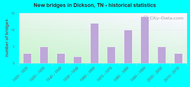
- New bridges - historical statistics
- 31920-1929
- 51930-1939
- 31940-1949
- 21950-1959
- 121960-1969
- 51970-1979
- 101980-1989
- 141990-1999
- 52000-2009
- 32010-2019
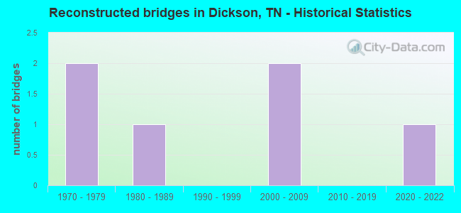
- Reconstructed bridges - Historical Statistics
- 21970-1979
- 11980-1989
- 01990-1999
- 22000-2009
- 02010-2019
- 12020-2022
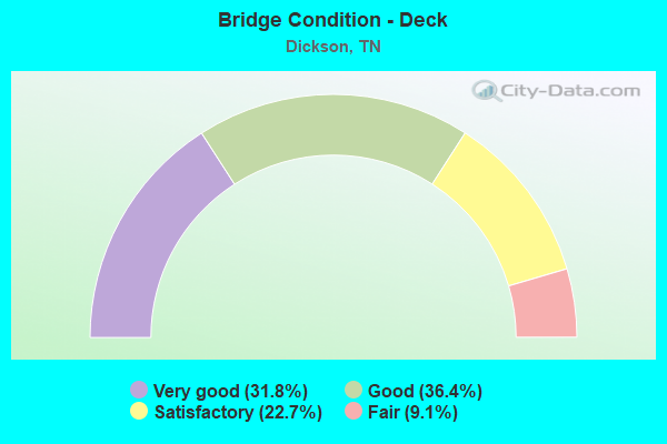
- Bridge Condition - Deck
- 31.8%Very good
- 36.4%Good
- 22.7%Satisfactory
- 9.1%Fair
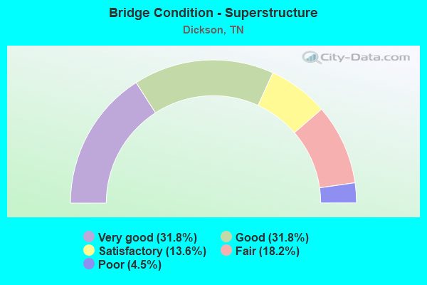
- Bridge Condition - Superstructure
- 31.8%Very good
- 31.8%Good
- 13.6%Satisfactory
- 18.2%Fair
- 4.5%Poor
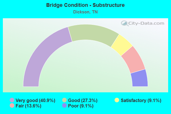
- Bridge Condition - Substructure
- 40.9%Very good
- 27.3%Good
- 9.1%Satisfactory
- 13.6%Fair
- 9.1%Poor
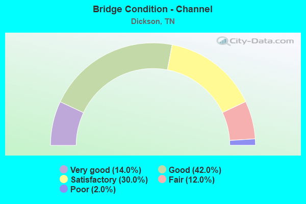
- Bridge Condition - Channel
- 14.0%Very good
- 42.0%Good
- 30.0%Satisfactory
- 12.0%Fair
- 2.0%Poor
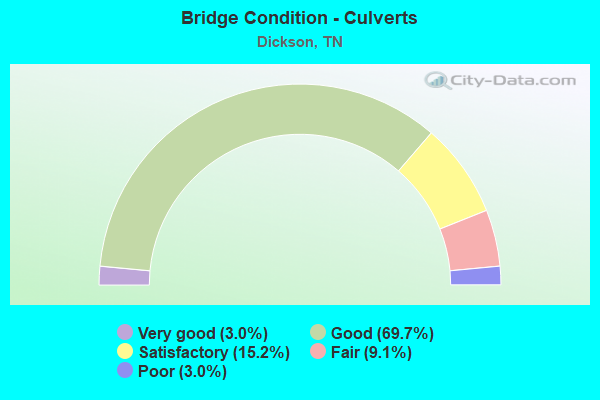
- Bridge Condition - Culverts
- 3.0%Very good
- 69.7%Good
- 15.2%Satisfactory
- 9.1%Fair
- 3.0%Poor
Find on map >> Show street view
Structure Number: 22S61470005, Location: 1.5 M. N. I40. (Lat: 36.032883, Lng: -87.401117), Route carried "on" structure: County highway 1854, Year Built: 1970, Status: Open, Structure Length: 2.04m (6.69ft), Average Daily Traffic: 772 (year 2020), Truck Traffic: 3%, Average Future Daily Traffic: 1,216 (year 2040), Features Intersected: EAST FORK PINEY RIVER
Minimum Vertical Clearance: 30+ m (98+ ft), Kilometerpoint: 8.143, Lanes on structure: 2, Owner: County Highway Agency, Approaching Roadway Width: 8.5m (27.9ft), Skew: 4 degrees, Material/Design: Concrete continuous, Design/Construction: Culvert, Number Of Spans In Main Unit: 3, Length of Maximum Span: 4.6m (15.1ft), Curb-To-Curb Width: 8.7m (28.5ft), Out-to-Out Width: 12.3m (40.4ft)
Condition: Channel: Fair, Culverts: Poor, Operating Rating: 42.3 metric tons, Method Used To Determine Operating Rating: Load Factor (LF), Inventory Rating: 25.2 metric tons, Method Used To Determine Inventory Rating: Load Factor (LF), Structural Evaluation: Meets minimum limits, Deck Geometry: Somewhat better than minimum adequacy, Waterway Adequacy: Equal to present minimum criteria, Approach Roadway Alignment: Equal to present minimum criteria, Length Of Structure Improvement: 2.04m (6.69ft), Designated Inspection Frequency: Every 24 months, Inspection Date: June 2020, Bridge Improvement Cost: $372,000, Roadway Improvement Cost: $38,000, Total Project Cost: $559,000 ( Estimate for 2020), Deck Structure Type: Concrete Cast-file-Place, Wearing Surface/Protective System: Wearing Surface: Bituminous
Find on map >> Show street view
Structure Number: 22S61470007, Location: 2.5 M. N. I40. (Lat: 36.052100, Lng: -87.397550), Route carried "on" structure: County highway 1854, Year Built: 1973, Status: Open, Structure Length: 1.46m (4.79ft), Average Daily Traffic: 772 (year 2020), Truck Traffic: 3%, Average Future Daily Traffic: 1,216 (year 2040), Design Load: H 15, Features Intersected: EAST FORK PINEY RIVER
Minimum Vertical Clearance: 30+ m (98+ ft), Kilometerpoint: 10.332, Lanes on structure: 2, Owner: County Highway Agency, Approaching Roadway Width: 7.3m (24.0ft), Material/Design: Concrete continuous, Design/Construction: Culvert, Number Of Spans In Main Unit: 3, Length of Maximum Span: 4.6m (15.1ft), Curb-To-Curb Width: 8.6m (28.2ft), Out-to-Out Width: 8.6m (28.2ft)
Condition: Channel: Good, Culverts: Good, Operating Rating: 64.8 metric tons, Method Used To Determine Operating Rating: Load Factor (LF), Inventory Rating: 32.4 metric tons, Method Used To Determine Inventory Rating: Load Factor (LF), Structural Evaluation: Better than present minimum criteria, Deck Geometry: Somewhat better than minimum adequacy, Waterway Adequacy: Better than present minimum criteria, Approach Roadway Alignment: Equal to present desirable criteria, Designated Inspection Frequency: Every 24 months, Inspection Date: June 2020, Deck Structure Type: Concrete Cast-file-Place, Wearing Surface/Protective System: Wearing Surface: Bituminous
Find on map >> Show street view
Structure Number: 22S62730003, Location: 5 M. NE. DICKSON (Lat: 36.114000, Lng: -87.294483), Route carried "on" structure: County highway 1860, Year Built: 1978, Status: Open, Structure Length: 3.69m (12.11ft), Average Daily Traffic: 577 (year 2020), Truck Traffic: 4%, Average Future Daily Traffic: 992 (year 2040), Design Load: HS 20, Features Intersected: JONES CREEK
Minimum Vertical Clearance: 30+ m (98+ ft), Kilometerpoint: 9.560, Lanes on structure: 2, Owner: County Highway Agency, Approaching Roadway Width: 6.1m (20.0ft), Material/Design: Prestressed concrete continuous, Design/Construction: Stringer/Multi-beam, Number Of Spans In Main Unit: 2, Length of Maximum Span: 18.0m (59.1ft), Curb-To-Curb Width: 7.3m (24.0ft), Out-to-Out Width: 8.6m (28.2ft)
Condition: Deck: Good, Superstructure: Good, Substructure: Good, Channel: Fair, Operating Rating: 44.1 metric tons, Method Used To Determine Operating Rating: Assigned rating based on Load Factor Design (LFD) reported in metric tons, Inventory Rating: 32.4 metric tons, Method Used To Determine Inventory Rating: Assigned rating based on Load Factor Design (LFD) reported in metric tons, Structural Evaluation: Better than present minimum criteria, Deck Geometry: Meets minimum limits, Waterway Adequacy: Better than present minimum criteria, Approach Roadway Alignment: Equal to present minimum criteria, Designated Inspection Frequency: Every 24 months, Inspection Date: June 2020, Deck Structure Type: Concrete Cast-file-Place, Wearing Surface/Protective System: Wearing Surface: Bituminous
Find on map >> Show street view
Structure Number: 22SR0010001, Location: 2 MI.E.OF TENN. CITY (Lat: 36.089050, Lng: -87.472467), Route carried "on" structure: US 70, Year Built: 1924, Year Reconstructed: 2012, Status: Open, Structure Length: 2.26m (7.41ft), Average Daily Traffic: 8,511 (year 2020), Truck Traffic: 7%, Average Future Daily Traffic: 13,840 (year 2040), Design Load: HS 20, Features Intersected: PINEY CREEK, Facility Carried by Structure: FAP 1
Minimum Vertical Clearance: 30+ m (98+ ft), Kilometerpoint: 6.711, Lanes on structure: 2, Base Highway Network: Yes, Owner: State Highway Agency, Approaching Roadway Width: 11.0m (36.1ft), Skew: 1 degrees, Material/Design: Concrete continuous, Design/Construction: Culvert, Number Of Spans In Main Unit: 2, Length of Maximum Span: 3.0m (9.8ft)
Condition: Channel: Good, Culverts: Satisfactory, Operating Rating: 54.0 metric tons, Method Used To Determine Operating Rating: Field evaluation and documented engineering judgment, Inventory Rating: 32.4 metric tons, Method Used To Determine Inventory Rating: Field evaluation and documented engineering judgment, Structural Evaluation: Equal to present minimum criteria, Waterway Adequacy: Equal to present desirable criteria, Approach Roadway Alignment: Equal to present desirable criteria, Designated Inspection Frequency: Every 24 months, Inspection Date: May 2020
Find on map >> Show street view
Structure Number: 22SR0010003, Location: .3 MI.W. OF DICKSON (Lat: 36.086067, Lng: -87.408117), Route carried "on" structure: US 70, Year Built: 1924, Status: Open, Structure Length: 0.67m (2.20ft), Average Daily Traffic: 11,600 (year 2020), Truck Traffic: 9%, Average Future Daily Traffic: 21,440 (year 2040), Design Load: HS 20, Features Intersected: PINEY CREEK, Facility Carried by Structure: FAP 1
Minimum Vertical Clearance: 30+ m (98+ ft), Kilometerpoint: 12.295, Lanes on structure: 4, Base Highway Network: Yes, Owner: State Highway Agency, Approaching Roadway Width: 32.3m (106.0ft), Material/Design: Concrete continuous, Design/Construction: Culvert, Number Of Spans In Main Unit: 2, Length of Maximum Span: 3.0m (9.8ft)
Condition: Channel: Satisfactory, Culverts: Satisfactory, Operating Rating: 54.0 metric tons, Method Used To Determine Operating Rating: Field evaluation and documented engineering judgment, Inventory Rating: 32.4 metric tons, Method Used To Determine Inventory Rating: Field evaluation and documented engineering judgment, Structural Evaluation: Equal to present minimum criteria, Waterway Adequacy: Equal to present desirable criteria, Approach Roadway Alignment: Equal to present desirable criteria, Designated Inspection Frequency: Every 24 months, Inspection Date: May 2020
Find on map >> Show street view
Structure Number: 22SR0010005, Location: W. COLLEGE ST.IN DICKSON (Lat: 36.085783, Lng: -87.401283), Route carried "on" structure: US 70, Year Built: 2009, Status: Open, Structure Length: 2.77m (9.09ft), Average Daily Traffic: 11,600 (year 2020), Truck Traffic: 9%, Average Future Daily Traffic: 21,440 (year 2040), Design Load: HL 93, Features Intersected: CSX RAILROAD, Facility Carried by Structure: FAP 1 350810G
Minimum Vertical Clearance: 30+ m (98+ ft), Kilometerpoint: 13.004, Lanes on structure: 5, Base Highway Network: Yes, Owner: State Highway Agency, Approaching Roadway Width: 25.6m (84.0ft), Skew: 14 degrees, Material/Design: Prestressed concrete, Design/Construction: Box Beam or Girders - Single/Spread, Number Of Spans In Main Unit: 1, Length of Maximum Span: 25.7m (84.3ft), Curb-To-Curb Width: 25.6m (84.0ft), Out-to-Out Width: 26.0m (85.3ft)
Condition: Deck: Very good, Superstructure: Good, Substructure: Very good, Operating Rating: 59.4 metric tons, Method Used To Determine Operating Rating: Load Factor (LF), Inventory Rating: 32.4 metric tons, Method Used To Determine Inventory Rating: Load Factor (LF), Structural Evaluation: Better than present minimum criteria, Deck Geometry: Superior to present desirable criteria, Underclear: Superior to present desirable criteria, Approach Roadway Alignment: Equal to present desirable criteria, Designated Inspection Frequency: Every 24 months, Inspection Date: May 2020, Deck Structure Type: Concrete Cast-file-Place, Wearing Surface/Protective System: Wearing Surface: Monolithic Concrete, Membrane: Epoxy, Deck Protection: Epoxy Coated Reinforcing
Find on map >> Show street view
Structure Number: 22SR0010007, Location: 2.1 MI.E.OF DICKSON (Lat: 36.081667, Lng: -87.346750), Route carried "on" structure: US 70, Year Built: 1939, Status: Open, Structure Length: 0.73m (2.40ft), Average Daily Traffic: 10,456 (year 2020), Truck Traffic: 9%, Average Future Daily Traffic: 26,128 (year 2040), Design Load: HS 20, Features Intersected: BRANCH, Facility Carried by Structure: FAP 1
Minimum Vertical Clearance: 30+ m (98+ ft), Kilometerpoint: 18.580, Lanes on structure: 4, Base Highway Network: Yes, Owner: State Highway Agency, Approaching Roadway Width: 20.4m (66.9ft), Skew: 1 degrees, Material/Design: Concrete continuous, Design/Construction: Culvert, Number Of Spans In Main Unit: 2, Length of Maximum Span: 3.0m (9.8ft)
Condition: Channel: Poor, Culverts: Fair, Operating Rating: 54.0 metric tons, Method Used To Determine Operating Rating: Load Factor (LF), Inventory Rating: 32.4 metric tons, Method Used To Determine Inventory Rating: Load Factor (LF), Structural Evaluation: Somewhat better than minimum adequacy, Waterway Adequacy: Equal to present minimum criteria, Approach Roadway Alignment: Equal to present desirable criteria, Length Of Structure Improvement: 0.73m (2.40ft), Designated Inspection Frequency: Every 24 months, Inspection Date: May 2020, Bridge Improvement Cost: $223,000, Roadway Improvement Cost: $23,000, Total Project Cost: $335,000 ( Estimate for 2020)
Find on map >> Show street view
Structure Number: 22SR0010009, Location: 3.5 MI.E.OF DICKSON (Lat: 36.087133, Lng: -87.322300), Route carried "on" structure: US 70, Year Built: 1939, Status: Open, Structure Length: 0.70m (2.30ft), Average Daily Traffic: 7,060 (year 2020), Truck Traffic: 9%, Average Future Daily Traffic: 14,304 (year 2040), Design Load: HS 20, Features Intersected: WOLFDEN BRANCH, Facility Carried by Structure: FAP 1
Minimum Vertical Clearance: 30+ m (98+ ft), Kilometerpoint: 20.857, Lanes on structure: 3, Base Highway Network: Yes, Owner: State Highway Agency, Approaching Roadway Width: 16.5m (54.1ft), Material/Design: Concrete continuous, Design/Construction: Culvert, Number Of Spans In Main Unit: 2, Length of Maximum Span: 3.0m (9.8ft)
Condition: Channel: Satisfactory, Culverts: Satisfactory, Operating Rating: 35.1 metric tons, Method Used To Determine Operating Rating: Load Factor (LF), Inventory Rating: 22.5 metric tons, Method Used To Determine Inventory Rating: Load Factor (LF), Structural Evaluation: Somewhat better than minimum adequacy, Waterway Adequacy: Somewhat better than minimum adequacy, Approach Roadway Alignment: Equal to present desirable criteria, Length Of Structure Improvement: 0.70m (2.30ft), Designated Inspection Frequency: Every 24 months, Inspection Date: May 2020, Bridge Improvement Cost: $180,000, Roadway Improvement Cost: $19,000, Total Project Cost: $271,000 ( Estimate for 2020)
Find on map >> Show street view
Structure Number: 22SR0480003, Location: 4.3 MI.S.W.OF DICKSON (Lat: 36.027883, Lng: -87.449917), Route carried "on" structure: State highway 48, Year Built: 1992, Status: Open, Structure Length: 5.18m (16.99ft), Average Daily Traffic: 2,624 (year 2020), Truck Traffic: 5%, Average Future Daily Traffic: 4,544 (year 2040), Design Load: HS 20, Features Intersected: PINEY RIVER
Minimum Vertical Clearance: 30+ m (98+ ft), Kilometerpoint: 6.502, Lanes on structure: 2, Owner: State Highway Agency, Approaching Roadway Width: 9.8m (32.2ft), Skew: 1 degrees, Material/Design: Prestressed concrete continuous, Design/Construction: Stringer/Multi-beam, Number Of Spans In Main Unit: 3, Length of Maximum Span: 17.1m (56.1ft), Curb-To-Curb Width: 9.8m (32.2ft), Out-to-Out Width: 10.4m (34.1ft)
Condition: Deck: Very good, Superstructure: Very good, Substructure: Very good, Channel: Good, Operating Rating: 54.9 metric tons, Method Used To Determine Operating Rating: Load Factor (LF), Inventory Rating: 32.4 metric tons, Method Used To Determine Inventory Rating: Load Factor (LF), Structural Evaluation: Equal to present desirable criteria, Deck Geometry: Meets minimum limits, Waterway Adequacy: Equal to present desirable criteria, Approach Roadway Alignment: Equal to present desirable criteria, Designated Inspection Frequency: Every 24 months, Inspection Date: May 2020, Deck Structure Type: Concrete Cast-file-Place, Wearing Surface/Protective System: Wearing Surface: Monolithic Concrete, Deck Protection: Epoxy Coated Reinforcing
Find on map >> Show street view
Structure Number: 22SR0480005, Location: 3.5 MI.S.W.OF DICKSON (Lat: 36.028550, Lng: -87.442483), Route carried "on" structure: State highway 48, Year Built: 1985, Status: Open, Structure Length: 0.82m (2.69ft), Average Daily Traffic: 2,624 (year 2020), Truck Traffic: 5%, Average Future Daily Traffic: 4,544 (year 2040), Design Load: HS 20, Features Intersected: BRANCH
Minimum Vertical Clearance: 30+ m (98+ ft), Kilometerpoint: 7.194, Lanes on structure: 2, Owner: State Highway Agency, Approaching Roadway Width: 8.5m (27.9ft), Skew: 1 degrees, Material/Design: Concrete continuous, Design/Construction: Culvert, Number Of Spans In Main Unit: 2, Length of Maximum Span: 3.7m (12.1ft), Curb-To-Curb Width: 8.6m (28.2ft), Out-to-Out Width: 9.7m (31.8ft)
Condition: Channel: Satisfactory, Culverts: Good, Operating Rating: 61.2 metric tons, Method Used To Determine Operating Rating: Load Factor (LF), Inventory Rating: 32.4 metric tons, Method Used To Determine Inventory Rating: Load Factor (LF), Structural Evaluation: Better than present minimum criteria, Deck Geometry: Meets minimum limits, Waterway Adequacy: Equal to present minimum criteria, Approach Roadway Alignment: Equal to present desirable criteria, Length Of Structure Improvement: 0.82m (2.69ft), Designated Inspection Frequency: Every 24 months, Inspection Date: May 2020, Bridge Improvement Cost: $82,000, Roadway Improvement Cost: $9,000, Total Project Cost: $124,000 ( Estimate for 2020), Deck Structure Type: Concrete Cast-file-Place, Wearing Surface/Protective System: Wearing Surface: Bituminous
Find on map >> Show street view
Structure Number: 22SR0480007, Location: IN DICKSON CITY LIMITS (Lat: 36.067583, Lng: -87.398633), Route carried "on" structure: State highway 48, Year Built: 1989, Year Reconstructed: 2006, Status: Open, Structure Length: 1.16m (3.81ft), Average Daily Traffic: 3,546 (year 2020), Truck Traffic: 2%, Average Future Daily Traffic: 5,744 (year 2040), Design Load: HS 20, Features Intersected: LITTLE PINEY RIVER
Minimum Vertical Clearance: 30+ m (98+ ft), Kilometerpoint: 13.840, Lanes on structure: 3, Owner: State Highway Agency, Approaching Roadway Width: 12.8m (42.0ft), Skew: 3 degrees, Material/Design: Concrete continuous, Design/Construction: Culvert, Number Of Spans In Main Unit: 2, Length of Maximum Span: 4.6m (15.1ft)
Condition: Channel: Satisfactory, Culverts: Satisfactory, Operating Rating: 89.1 metric tons, Method Used To Determine Operating Rating: Load Factor (LF), Inventory Rating: 32.4 metric tons, Method Used To Determine Inventory Rating: Load Factor (LF), Structural Evaluation: Equal to present minimum criteria, Waterway Adequacy: Equal to present minimum criteria, Approach Roadway Alignment: Equal to present desirable criteria, Length Of Structure Improvement: 1.16m (3.81ft), Designated Inspection Frequency: Every 24 months, Inspection Date: May 2020, Bridge Improvement Cost: $57,000, Roadway Improvement Cost: $6,000, Total Project Cost: $86,000 ( Estimate for 2020)
Find on map >> Show street view
Structure Number: 22SR0480009, Location: 2.7 MI.N.OF DICKSON (Lat: 36.128950, Lng: -87.359400), Route carried "on" structure: State highway 48, Year Built: 1929, Year Reconstructed: 1988, Status: Open, Structure Length: 3.23m (10.60ft), Average Daily Traffic: 8,720 (year 2020), Truck Traffic: 7%, Average Future Daily Traffic: 13,072 (year 2040), Design Load: HS 20, Features Intersected: JONES CREEK
Minimum Vertical Clearance: 30+ m (98+ ft), Kilometerpoint: 21.968, Lanes on structure: 2, Base Highway Network: Yes, Owner: State Highway Agency, Approaching Roadway Width: 9.1m (29.9ft), Skew: 2 degrees, Material/Design: Concrete, Design/Construction: Tee Beam, Number Of Spans In Main Unit: 4, Length of Maximum Span: 8.2m (26.9ft), Curb-To-Curb Width: 10.4m (34.1ft), Out-to-Out Width: 11.0m (36.1ft)
Condition: Deck: Fair, Superstructure: Fair, Substructure: Fair, Channel: Satisfactory, Operating Rating: 44.1 metric tons, Method Used To Determine Operating Rating: Assigned rating based on Load Factor Design (LFD) reported in metric tons, Inventory Rating: 32.4 metric tons, Method Used To Determine Inventory Rating: Assigned rating based on Load Factor Design (LFD) reported in metric tons, Structural Evaluation: Somewhat better than minimum adequacy, Deck Geometry: Meets minimum limits, Waterway Adequacy: Equal to present minimum criteria, Approach Roadway Alignment: Equal to present desirable criteria, Length Of Structure Improvement: 3.23m (10.60ft), Designated Inspection Frequency: Every 24 months, Inspection Date: May 2020, Bridge Improvement Cost: $285,000, Roadway Improvement Cost: $29,000, Total Project Cost: $428,000 ( Estimate for 2020), Deck Structure Type: Concrete Cast-file-Place, Wearing Surface/Protective System: Wearing Surface: Monolithic Concrete, Deck Protection: Epoxy Coated Reinforcing
Find on map >> Show street view
Structure Number: 43017790007, Location: 2 M. S. SR 1 (Lat: 36.073933, Lng: -87.439183), Route carried "on" structure: County highway 1779, Year Built: 1987, Status: Open, Structure Length: 4.33m (14.21ft), Average Daily Traffic: 165 (year 2020), Truck Traffic: 3%, Average Future Daily Traffic: 320 (year 2040), Design Load: HS 20, Features Intersected: HURRICANE CREEK
Minimum Vertical Clearance: 30+ m (98+ ft), Kilometerpoint: 12.859, Lanes on structure: 2, Owner: County Highway Agency, Approaching Roadway Width: 8.5m (27.9ft), Skew: 3 degrees, Material/Design: Prestressed concrete continuous, Design/Construction: Box Beam or Girders - Single/Spread, Number Of Spans In Main Unit: 3, Length of Maximum Span: 14.3m (46.9ft), Curb-To-Curb Width: 7.3m (24.0ft), Out-to-Out Width: 7.9m (25.9ft)
Condition: Deck: Good, Superstructure: Good, Substructure: Very good, Channel: Satisfactory, Operating Rating: 57.8 metric tons, Method Used To Determine Operating Rating: Load Factor (LF), Inventory Rating: 32.4 metric tons, Method Used To Determine Inventory Rating: Load Factor (LF), Structural Evaluation: Better than present minimum criteria, Deck Geometry: Somewhat better than minimum adequacy, Waterway Adequacy: Equal to present desirable criteria, Approach Roadway Alignment: Equal to present minimum criteria, Designated Inspection Frequency: Every 24 months, Inspection Date: January 2022, Deck Structure Type: Concrete Precast Panels, Wearing Surface/Protective System: Wearing Surface: Monolithic Concrete, Deck Protection: Epoxy Coated Reinforcing
Find on map >> Show street view
Structure Number: 22031500003, Location: IN THE CITY OF DICKSON (Lat: 36.076900, Lng: -87.390967), Route carried "under" structure: City street 3150, Year Built: 1930, Structure Length: 0. m, Average Daily Traffic: 1,515 (year 2020), Truck Traffic: 4%, Features Intersected: CSX RR / SO. CHARLOTTE, Facility Carried by Structure: CSX RR 348091X
Minimum Vertical Clearance: 2.60m (8.53ft), Kilometerpoint: 0.161, Lanes under structure: 1, Material/Design: Concrete, Design/Construction: Culvert, Length of Maximum Span: 4.6m (15.1ft)
Find on map >> Show street view
Structure Number: 22FA0360001, Location: NEAR DICKSON TENN. (Lat: 36.081667, Lng: -87.380000), Route carried "under" structure: US 70, Year Built: 2008, Structure Length: 0. m, Average Daily Traffic: 11,429 (year 2020), Truck Traffic: 9%, Features Intersected: SR 48 / SR 1, Facility Carried by Structure: FAU 48
Minimum Vertical Clearance: 4.88m (16.01ft), Kilometerpoint: 14.967, Lanes on structure: 4, Lanes under structure: 4, Material/Design: Prestressed concrete continuous, Design/Construction: Stringer/Multi-beam, Length of Maximum Span: 38.9m (127.6ft)
Find on map >> Show street view
Structure Number: 22I00400005, Location: 5 M S OF DICKSON (Lat: 36.006950, Lng: -87.404517), Route carried "under" structure: County highway 1854, Year Built: 1963, Structure Length: 0. m, Average Daily Traffic: 772 (year 2020), Truck Traffic: 3%, Features Intersected: I40 RL / EAST PINEY RD., Facility Carried by Structure: I40
Minimum Vertical Clearance: 3.97m (13.02ft), Kilometerpoint: 4.216, Lanes on structure: 2, Lanes under structure: 2, Material/Design: Concrete, Design/Construction: Tee Beam, Length of Maximum Span: 13.4m (44.0ft)
Find on map >> Show street view
Structure Number: 22I00400006, Location: 5 M S OF DICKSON (Lat: 36.007567, Lng: -87.404467), Route carried "under" structure: County highway 1854, Year Built: 1963, Structure Length: 0. m, Average Daily Traffic: 772 (year 2020), Truck Traffic: 3%, Features Intersected: I40 LL / EAST PINEY RD., Facility Carried by Structure: I40
Minimum Vertical Clearance: 3.97m (13.02ft), Kilometerpoint: 4.265, Lanes on structure: 2, Lanes under structure: 2, Material/Design: Concrete, Design/Construction: Tee Beam, Length of Maximum Span: 13.4m (44.0ft)
Find on map >> Show street view
Structure Number: 22I00400007, Location: NEAR DICKSON TENN. (Lat: 36.018333, Lng: -87.338333), Route carried "under" structure: Interstate 40, Year Built: 1962, Structure Length: 0. m, Average Daily Traffic: 32,099 (year 2020), Truck Traffic: 31%, Features Intersected: CSX RAILROAD / I40, Facility Carried by Structure: CSX RR 351047N
Minimum Vertical Clearance: 5.11m (16.77ft), Kilometerpoint: 14.581, Lanes under structure: 4, Material/Design: Steel continuous, Design/Construction: Stringer/Multi-beam, Length of Maximum Span: 24.1m (79.1ft)
Find on map >> Show street view
Structure Number: 22I00400009, Location: NEAR DICKSON TENN. (Lat: 36.018333, Lng: -87.336667), Route carried "under" structure: Interstate 40, Year Built: 1994, Structure Length: 0. m, Average Daily Traffic: 32,099 (year 2020), Truck Traffic: 31%, Features Intersected: SR 46 / I40, Facility Carried by Structure: FAP 46
Minimum Vertical Clearance: 5.08m (16.67ft), Kilometerpoint: 14.629, Lanes on structure: 6, Lanes under structure: 5, Material/Design: Prestressed concrete continuous, Design/Construction: Box Beam or Girders - Single/Spread, Length of Maximum Span: 25.3m (83.0ft)
Find on map >> Show street view
Structure Number: 22SR0460003, Location: DICKSON (Lat: 36.070533, Lng: -87.380317), Route carried "under" structure: State highway 46, Year Built: 1988, Structure Length: 0. m, Average Daily Traffic: 27,245 (year 2020), Truck Traffic: 9%, Features Intersected: CSX RAILROAD / SR 46, Facility Carried by Structure: CSX RR 348084M
Minimum Vertical Clearance: 5.89m (19.32ft), Kilometerpoint: 13.052, Lanes under structure: 4, Material/Design: Steel, Design/Construction: Stringer/Multi-beam, Length of Maximum Span: 28.0m (91.9ft)