Bridge Statistics for Dike, Iowa (IA)
Condition, Traffic, Stress, Structural Evaluation, Project Costs
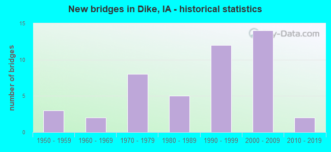
- New bridges - historical statistics
- 31950-1959
- 21960-1969
- 81970-1979
- 51980-1989
- 121990-1999
- 142000-2009
- 22010-2019


- Bridge Condition - Deck
- 3.4%Excellent
- 24.1%Very good
- 34.5%Good
- 13.8%Satisfactory
- 20.7%Fair
- 3.4%Poor

- Bridge Condition - Superstructure
- 10.3%Excellent
- 41.4%Very good
- 10.3%Good
- 17.2%Satisfactory
- 17.2%Fair
- 3.4%Poor

- Bridge Condition - Substructure
- 3.4%Excellent
- 31.0%Very good
- 34.5%Good
- 6.9%Satisfactory
- 3.4%Fair
- 6.9%Poor
- 13.8%Serious

- Bridge Condition - Channel
- 22.2%Very good
- 36.1%Good
- 30.6%Satisfactory
- 11.1%Fair

- Bridge Condition - Culverts
- 8.3%Excellent
- 41.7%Good
- 33.3%Satisfactory
- 16.7%Fair
Find on map >> Show street view
Structure Number: 4144, Location: 088150501 (Lat: 42.457036, Lng: -92.631842), Route carried "on" structure: City street , Year Built: 1977, Status: Open, Structure Length: 3.90m (12.80ft), Average Daily Traffic: 1,430 (year 2021), Average Future Daily Traffic: 1,430 (year 2040), Design Load: H 20, Features Intersected: BLACKHAWK CREEK, Facility Carried by Structure: FIRST ST
Minimum Vertical Clearance: 30+ m (98+ ft), Kilometerpoint: 0.066, Lanes on structure: 2, Owner: City or Municipal Highway Agency, Approaching Roadway Width: 6.7m (22.0ft), Material/Design: Concrete continuous, Design/Construction: Slab, Number Of Spans In Main Unit: 3, Length of Maximum Span: 14.9m (48.9ft), Curb or Sidewalk Widths: Left: 0.3m (1.0ft), Right: 0.3m (1.0ft), Curb-To-Curb Width: 9.1m (29.9ft), Out-to-Out Width: 9.8m (32.2ft)
Condition: Deck: Satisfactory, Superstructure: Satisfactory, Substructure: Satisfactory, Channel: Satisfactory, Operating Rating: 51.7 metric tons, Method Used To Determine Operating Rating: Allowable Stress (AS), Inventory Rating: 29.9 metric tons, Method Used To Determine Inventory Rating: Allowable Stress (AS), Structural Evaluation: Equal to present minimum criteria, Deck Geometry: Somewhat better than minimum adequacy, Waterway Adequacy: Better than present minimum criteria, Approach Roadway Alignment: Equal to present minimum criteria, Length Of Structure Improvement: 12.80m (41.99ft), Designated Inspection Frequency: Every 24 months, Inspection Date: March 2020, Bridge Improvement Cost: $15,000, Roadway Improvement Cost: $2,000, Deck Structure Type: Concrete Cast-file-Place, Wearing Surface/Protective System: Wearing Surface: Monolithic Concrete
Find on map >> Show street view
Structure Number: 4146, Location: 088150501 (Lat: 42.459003, Lng: -92.631839), Route carried "on" structure: City street , Year Built: 1977, Status: Open, Structure Length: 3.14m (10.30ft), Average Daily Traffic: 1,430 (year 2021), Average Future Daily Traffic: 1,430 (year 2040), Design Load: H 20, Features Intersected: BLACKHAWK CREEK, Facility Carried by Structure: FIRST ST
Minimum Vertical Clearance: 30+ m (98+ ft), Kilometerpoint: 0.285, Lanes on structure: 2, Owner: City or Municipal Highway Agency, Approaching Roadway Width: 6.7m (22.0ft), Skew: 3 degrees, Material/Design: Concrete continuous, Design/Construction: Slab, Number Of Spans In Main Unit: 3, Length of Maximum Span: 11.9m (39.0ft), Curb or Sidewalk Widths: Left: 0.3m (1.0ft), Right: 0.3m (1.0ft), Curb-To-Curb Width: 14.0m (45.9ft), Out-to-Out Width: 15.0m (49.2ft)
Condition: Deck: Satisfactory, Superstructure: Satisfactory, Substructure: Good, Channel: Satisfactory, Operating Rating: 49.9 metric tons, Method Used To Determine Operating Rating: Allowable Stress (AS), Inventory Rating: 29.9 metric tons, Method Used To Determine Inventory Rating: Allowable Stress (AS), Structural Evaluation: Equal to present minimum criteria, Deck Geometry: Superior to present desirable criteria, Waterway Adequacy: Better than present minimum criteria, Approach Roadway Alignment: Better than present minimum criteria, Length Of Structure Improvement: 10.30m (33.79ft), Designated Inspection Frequency: Every 24 months, Inspection Date: March 2020, Bridge Improvement Cost: $15,000, Roadway Improvement Cost: $2,000, Deck Structure Type: Concrete Cast-file-Place, Wearing Surface/Protective System: Wearing Surface: Monolithic Concrete
Find on map >> Show street view
Structure Number: 25871, Location: 088160101 (Lat: 42.469864, Lng: -92.670114), Route carried "on" structure: County highway , Year Built: 1984, Status: Open, Structure Length: 2.53m (8.30ft), Average Daily Traffic: 800 (year 2021), Truck Traffic: 11%, Average Future Daily Traffic: 800 (year 2040), Design Load: HS 20, Features Intersected: TRIB BLACKHAWK CREEK, Facility Carried by Structure: D19 160TH ST
Minimum Vertical Clearance: 30+ m (98+ ft), Kilometerpoint: 22.767, Lanes on structure: 2, Owner: County Highway Agency, Approaching Roadway Width: 12.8m (42.0ft), Material/Design: Concrete continuous, Design/Construction: Slab, Number Of Spans In Main Unit: 3, Length of Maximum Span: 9.4m (30.8ft), Curb-To-Curb Width: 12.2m (40.0ft), Out-to-Out Width: 13.2m (43.3ft)
Condition: Deck: Satisfactory, Superstructure: Satisfactory, Substructure: Satisfactory, Channel: Good, Operating Rating: 86.3 metric tons, Method Used To Determine Operating Rating: Load Factor (LF), Inventory Rating: 51.7 metric tons, Method Used To Determine Inventory Rating: Load Factor (LF), Structural Evaluation: Equal to present minimum criteria, Deck Geometry: Equal to present desirable criteria, Waterway Adequacy: Better than present minimum criteria, Approach Roadway Alignment: Better than present minimum criteria, Length Of Structure Improvement: 8.30m (27.23ft), Designated Inspection Frequency: Every 48 months, Inspection Date: March 2020, Bridge Improvement Cost: $15,000, Roadway Improvement Cost: $2,000, Deck Structure Type: Concrete Cast-file-Place, Wearing Surface/Protective System: Wearing Surface: Monolithic Concrete, Deck Protection: Epoxy Coated Reinforcing
Find on map >> Show street view
Structure Number: 25881, Location: 088160101 (Lat: 42.469831, Lng: -92.656822), Route carried "on" structure: County highway , Year Built: 2004, Status: Open, Structure Length: 7.41m (24.31ft), Average Daily Traffic: 800 (year 2021), Truck Traffic: 11%, Average Future Daily Traffic: 800 (year 2040), Design Load: HS 20, Features Intersected: BR N BLACKHAWK CREEK, Facility Carried by Structure: FM
Minimum Vertical Clearance: 30+ m (98+ ft), Kilometerpoint: 23.860, Lanes on structure: 2, Owner: County Highway Agency, Approaching Roadway Width: 15.2m (49.9ft), Material/Design: Prestressed concrete, Design/Construction: Stringer/Multi-beam, Number Of Spans In Main Unit: 3, Length of Maximum Span: 32.3m (106.0ft), Curb-To-Curb Width: 9.8m (32.2ft), Out-to-Out Width: 10.4m (34.1ft)
Condition: Deck: Very good, Superstructure: Very good, Substructure: Very good, Channel: Very good, Operating Rating: 63.7 metric tons, Method Used To Determine Operating Rating: Load Factor (LF), Inventory Rating: 34.3 metric tons, Method Used To Determine Inventory Rating: Load Factor (LF), Structural Evaluation: Equal to present desirable criteria, Deck Geometry: Equal to present minimum criteria, Waterway Adequacy: Superior to present desirable criteria, Approach Roadway Alignment: Better than present minimum criteria, Length Of Structure Improvement: 24.30m (79.72ft), Designated Inspection Frequency: Every 24 months, Inspection Date: March 2020, Bridge Improvement Cost: $15,000, Roadway Improvement Cost: $2,000, Deck Structure Type: Concrete Cast-file-Place, Wearing Surface/Protective System: Wearing Surface: Monolithic Concrete
Find on map >> Show street view
Structure Number: 25891, Location: 088150303 (Lat: 42.469767, Lng: -92.633408), Route carried "on" structure: County highway , Year Built: 1985, Status: Open, Structure Length: 1.16m (3.81ft), Average Daily Traffic: 800 (year 2021), Truck Traffic: 11%, Average Future Daily Traffic: 800 (year 2040), Design Load: HS 20, Features Intersected: BR N BLACKHAWK CREEK, Facility Carried by Structure: D19 160TH ST
Minimum Vertical Clearance: 30+ m (98+ ft), Kilometerpoint: 25.785, Lanes on structure: 2, Owner: County Highway Agency, Approaching Roadway Width: 14.6m (47.9ft), Material/Design: Concrete continuous, Design/Construction: Culvert, Number Of Spans In Main Unit: 3, Length of Maximum Span: 3.7m (12.1ft)
Condition: Channel: Good, Culverts: Satisfactory, Operating Rating: 44.1 metric tons, Method Used To Determine Operating Rating: Assigned rating based on Load Factor Design (LFD) reported in metric tons, Inventory Rating: 32.7 metric tons, Method Used To Determine Inventory Rating: Assigned rating based on Load Factor Design (LFD) reported in metric tons, Structural Evaluation: Equal to present minimum criteria, Waterway Adequacy: Better than present minimum criteria, Approach Roadway Alignment: Equal to present desirable criteria, Length Of Structure Improvement: 3.80m (12.47ft), Designated Inspection Frequency: Every 48 months, Inspection Date: March 2020, Bridge Improvement Cost: $15,000, Roadway Improvement Cost: $2,000
Find on map >> Show street view
Structure Number: 7595, Location: 89-14-31-01-10 (Lat: 42.484169, Lng: -92.552964), Route carried "on" structure: County highway , Year Built: 2003, Status: Open, Structure Length: 0.67m (2.20ft), Average Daily Traffic: 60 (year 2017), Average Future Daily Traffic: 60 (year 2038), Design Load: HS 20, Features Intersected: TRIB TO BEAVER CREEK, Facility Carried by Structure: VIKING RD
Minimum Vertical Clearance: 30+ m (98+ ft), Kilometerpoint: 0.114, Lanes on structure: 2, Owner: County Highway Agency, Approaching Roadway Width: 9.1m (29.9ft), Material/Design: Steel, Design/Construction: Stringer/Multi-beam, Number Of Spans In Main Unit: 1, Length of Maximum Span: 6.4m (21.0ft), Curb-To-Curb Width: 9.3m (30.5ft), Out-to-Out Width: 9.4m (30.8ft)
Condition: Deck: Good, Superstructure: Good, Substructure: Good, Channel: Good, Inventory Rating: 89.7 metric tons, Method Used To Determine Inventory Rating: Allowable Stress (AS), Structural Evaluation: Better than present minimum criteria, Deck Geometry: Better than present minimum criteria, Waterway Adequacy: Equal to present desirable criteria, Approach Roadway Alignment: Equal to present desirable criteria, Designated Inspection Frequency: Every 48 months, Inspection Date: December 2018, Deck Structure Type: Concrete Cast-file-Place, Wearing Surface/Protective System: Wearing Surface: Monolithic Concrete
Find on map >> Show street view
Structure Number: 164631, Location: 088150802 (Lat: 42.451283, Lng: -92.631811), Route carried "on" structure: County highway , Year Built: 1974, Status: Open, Structure Length: 3.90m (12.80ft), Average Daily Traffic: 1,430 (year 2021), Truck Traffic: 13%, Average Future Daily Traffic: 1,430 (year 2040), Design Load: H 20, Features Intersected: BLACK HAWK CREEK, Facility Carried by Structure: FM
Minimum Vertical Clearance: 30+ m (98+ ft), Kilometerpoint: 17.148, Lanes on structure: 2, Owner: County Highway Agency, Approaching Roadway Width: 6.7m (22.0ft), Material/Design: Concrete continuous, Design/Construction: Slab, Number Of Spans In Main Unit: 3, Length of Maximum Span: 14.9m (48.9ft), Curb or Sidewalk Widths: Left: 0.3m (1.0ft), Right: 0.3m (1.0ft), Curb-To-Curb Width: 9.1m (29.9ft), Out-to-Out Width: 9.8m (32.2ft)
Condition: Deck: Fair, Superstructure: Fair, Substructure: Good, Channel: Satisfactory, Operating Rating: 51.7 metric tons, Method Used To Determine Operating Rating: Allowable Stress (AS), Inventory Rating: 29.9 metric tons, Method Used To Determine Inventory Rating: Allowable Stress (AS), Structural Evaluation: Somewhat better than minimum adequacy, Deck Geometry: Somewhat better than minimum adequacy, Waterway Adequacy: Equal to present desirable criteria, Approach Roadway Alignment: Better than present minimum criteria, Length Of Structure Improvement: 12.80m (41.99ft), Designated Inspection Frequency: Every 24 months, Inspection Date: March 2020, Bridge Improvement Cost: $15,000, Roadway Improvement Cost: $2,000, Deck Structure Type: Concrete Cast-file-Place, Wearing Surface/Protective System: Wearing Surface: Monolithic Concrete
Find on map >> Show street view
Structure Number: 164661, Location: 088151001 (Lat: 42.456569, Lng: -92.591742), Route carried "on" structure: County highway , Year Built: 1987, Status: Open, Structure Length: 0.70m (2.30ft), Average Daily Traffic: 10 (year 2017), Average Future Daily Traffic: 10 (year 2040), Design Load: HS 20, Features Intersected: BRANCH OF BLACKHAWK CREE, Facility Carried by Structure: LOCAL
Minimum Vertical Clearance: 30+ m (98+ ft), Kilometerpoint: 23.390, Lanes on structure: 2, Owner: County Highway Agency, Approaching Roadway Width: 7.9m (25.9ft), Material/Design: Concrete continuous, Design/Construction: Culvert, Number Of Spans In Main Unit: 2, Length of Maximum Span: 3.0m (9.8ft)
Condition: Channel: Good, Culverts: Good, Operating Rating: 44.1 metric tons, Method Used To Determine Operating Rating: Assigned rating based on Load Factor Design (LFD) reported in metric tons, Inventory Rating: 32.7 metric tons, Method Used To Determine Inventory Rating: Assigned rating based on Load Factor Design (LFD) reported in metric tons, Structural Evaluation: Better than present minimum criteria, Waterway Adequacy: Equal to present desirable criteria, Approach Roadway Alignment: Better than present minimum criteria, Length Of Structure Improvement: 2.30m (7.55ft), Designated Inspection Frequency: Every 48 months, Inspection Date: March 2020, Bridge Improvement Cost: $15,000, Roadway Improvement Cost: $2,000
Find on map >> Show street view
Structure Number: 164671, Location: 088151102 (Lat: 42.442614, Lng: -92.573050), Route carried "on" structure: County highway , Year Built: 2006, Status: Open, Structure Length: 6.13m (20.11ft), Average Daily Traffic: 50 (year 2017), Average Future Daily Traffic: 50 (year 2040), Design Load: HS 20, Features Intersected: BRANCH BLACK HAWK CREEK, Facility Carried by Structure: LOCAL ROAD
Minimum Vertical Clearance: 30+ m (98+ ft), Kilometerpoint: 14.080, Lanes on structure: 2, Owner: County Highway Agency, Approaching Roadway Width: 9.1m (29.9ft), Material/Design: Prestressed concrete, Design/Construction: Stringer/Multi-beam, Number Of Spans In Main Unit: 3, Length of Maximum Span: 22.3m (73.2ft), Curb-To-Curb Width: 9.3m (30.5ft), Out-to-Out Width: 10.1m (33.1ft)
Condition: Deck: Very good, Superstructure: Very good, Substructure: Very good, Channel: Very good, Operating Rating: 75.1 metric tons, Method Used To Determine Operating Rating: Load Factor (LF), Inventory Rating: 44.7 metric tons, Method Used To Determine Inventory Rating: Load Factor (LF), Structural Evaluation: Equal to present desirable criteria, Deck Geometry: Better than present minimum criteria, Waterway Adequacy: Equal to present desirable criteria, Approach Roadway Alignment: Better than present minimum criteria, Length Of Structure Improvement: 20.10m (65.94ft), Designated Inspection Frequency: Every 48 months, Inspection Date: March 2020, Bridge Improvement Cost: $15,000, Roadway Improvement Cost: $2,000, Deck Structure Type: Concrete Cast-file-Place, Wearing Surface/Protective System: Wearing Surface: Monolithic Concrete
Find on map >> Show street view
Structure Number: 164682, Location: 088151203 (Lat: 42.449306, Lng: -92.551033), Route carried "on" structure: County highway , Year Built: 2015, Status: Open, Structure Length: 0.82m (2.69ft), Average Daily Traffic: 70 (year 2017), Average Future Daily Traffic: 70 (year 2038), Design Load: HS 20, Features Intersected: BRANCH BLACK HAWK CREEK, Facility Carried by Structure: 175TH ST
Minimum Vertical Clearance: 30+ m (98+ ft), Kilometerpoint: 6.656, Lanes on structure: 2, Owner: County Highway Agency, Approaching Roadway Width: 7.3m (24.0ft), Skew: 1 degrees, Material/Design: Steel, Design/Construction: Culvert, Number Of Spans In Main Unit: 3, Length of Maximum Span: 2.0m (6.6ft)
Condition: Channel: Very good, Culverts: Excellent, Operating Rating: 44.1 metric tons, Method Used To Determine Operating Rating: Assigned rating based on Load Factor Design (LFD) reported in metric tons, Inventory Rating: 32.7 metric tons, Method Used To Determine Inventory Rating: Assigned rating based on Load Factor Design (LFD) reported in metric tons, Structural Evaluation: Superior to present desirable criteria, Waterway Adequacy: Equal to present desirable criteria, Approach Roadway Alignment: Better than present minimum criteria, Designated Inspection Frequency: Every 48 months, Inspection Date: April 2018
Find on map >> Show street view
Structure Number: 164691, Location: 088151801 (Lat: 42.441997, Lng: -92.638942), Route carried "on" structure: County highway , Year Built: 2015, Status: Open, Structure Length: 5.09m (16.70ft), Average Daily Traffic: 45 (year 2017), Average Future Daily Traffic: 45 (year 2038), Design Load: HL 93, Features Intersected: BLACK HAWK CREEK, Facility Carried by Structure: 180TH ST
Minimum Vertical Clearance: 30+ m (98+ ft), Kilometerpoint: 13.953, Lanes on structure: 2, Owner: County Highway Agency, Approaching Roadway Width: 6.7m (22.0ft), Material/Design: Prestressed concrete, Design/Construction: Stringer/Multi-beam, Number Of Spans In Main Unit: 3, Length of Maximum Span: 18.6m (61.0ft), Curb-To-Curb Width: 9.1m (29.9ft), Out-to-Out Width: 10.0m (32.8ft)
Condition: Deck: Excellent, Superstructure: Excellent, Substructure: Excellent, Channel: Good, Operating Rating: 42.1 metric tons, Method Used To Determine Operating Rating: Assigned ratings based on Load and Resistance Factor Design (LRFD) reported by rating factor (RF) using HL93 loadings, Inventory Rating: 32.4 metric tons, Method Used To Determine Inventory Rating: Assigned ratings based on Load and Resistance Factor Design (LRFD) reported by rating factor (RF) using HL93 loadings, Structural Evaluation: Equal to present desirable criteria, Deck Geometry: Better than present minimum criteria, Waterway Adequacy: Superior to present desirable criteria, Approach Roadway Alignment: Equal to present desirable criteria, Designated Inspection Frequency: Every 48 months, Inspection Date: April 2018, Deck Structure Type: Concrete Cast-file-Place, Wearing Surface/Protective System: Wearing Surface: Monolithic Concrete
Find on map >> Show street view
Structure Number: 164701, Location: 088151802 (Lat: 42.434364, Lng: -92.651794), Route carried "on" structure: County highway , Year Built: 1971, Status: Posted for load, Structure Length: 2.83m (9.28ft), Average Daily Traffic: 30 (year 2017), Average Future Daily Traffic: 30 (year 2041), Features Intersected: BRANCH BLACK HAWK CREEK, Facility Carried by Structure: LOCAL ROAD
Minimum Vertical Clearance: 30+ m (98+ ft), Kilometerpoint: 10.610, Lanes on structure: 2, Owner: County Highway Agency, Approaching Roadway Width: 7.9m (25.9ft), Material/Design: Wood or Timber, Design/Construction: Stringer/Multi-beam, Number Of Spans In Main Unit: 4, Length of Maximum Span: 7.0m (23.0ft), Curb-To-Curb Width: 7.1m (23.3ft), Out-to-Out Width: 7.3m (24.0ft)
Condition: Deck: Fair, Superstructure: Fair, Substructure: Serious, Channel: Fair, Operating Rating: 13.9 metric tons, Method Used To Determine Operating Rating: Allowable Stress (AS), Inventory Rating: 10.0 metric tons, Method Used To Determine Inventory Rating: Allowable Stress (AS), Structural Evaluation: High priority of replacement, Deck Geometry: Somewhat better than minimum adequacy, Waterway Adequacy: Better than present minimum criteria, Approach Roadway Alignment: Better than present minimum criteria, Bridge Posting: Required (Relationship of Operating Rating to Maximum Legal Load: > 39.9% below), Length Of Structure Improvement: 12.50m (41.01ft), Designated Inspection Frequency: Every 12 months, Inspection Date: April 2021, Bridge Improvement Cost: $270,000, Roadway Improvement Cost: $27,000, Deck Structure Type: Wood or Timber, Wearing Surface/Protective System: Wearing Surface: Bituminous
Find on map >> Show street view
Structure Number: 164715, Location: 088152002 (Lat: 42.415744, Lng: -92.631217), Route carried "on" structure: County highway , Year Built: 1977, Status: Open, Structure Length: 0.67m (2.20ft), Average Daily Traffic: 1,070 (year 2021), Average Future Daily Traffic: 1,070 (year 2038), Design Load: HS 20, Features Intersected: BR BLACKHAWK CK, Facility Carried by Structure: FM
Minimum Vertical Clearance: 30+ m (98+ ft), Kilometerpoint: 13.201, Lanes on structure: 2, Owner: County Highway Agency, Approaching Roadway Width: 6.7m (22.0ft), Material/Design: Concrete continuous, Design/Construction: Culvert, Number Of Spans In Main Unit: 2, Length of Maximum Span: 3.0m (9.8ft)
Condition: Channel: Satisfactory, Culverts: Satisfactory, Operating Rating: 44.1 metric tons, Method Used To Determine Operating Rating: Assigned rating based on Load Factor Design (LFD) reported in metric tons, Inventory Rating: 32.7 metric tons, Method Used To Determine Inventory Rating: Assigned rating based on Load Factor Design (LFD) reported in metric tons, Structural Evaluation: Equal to present minimum criteria, Waterway Adequacy: Better than present minimum criteria, Approach Roadway Alignment: Equal to present desirable criteria, Length Of Structure Improvement: 2.20m (7.22ft), Designated Inspection Frequency: Every 48 months, Inspection Date: April 2018, Bridge Improvement Cost: $15,000, Roadway Improvement Cost: $2,000
Find on map >> Show street view
Structure Number: 164721, Location: 088152102 (Lat: 42.421278, Lng: -92.611972), Route carried "on" structure: County highway , Year Built: 1978, Status: Posted for load, Structure Length: 1.16m (3.81ft), Average Daily Traffic: 10 (year 2017), Average Future Daily Traffic: 10 (year 2041), Features Intersected: SMALL, Facility Carried by Structure: LOCAL
Minimum Vertical Clearance: 30+ m (98+ ft), Kilometerpoint: 13.815, Lanes on structure: 2, Owner: County Highway Agency, Approaching Roadway Width: 6.7m (22.0ft), Material/Design: Wood or Timber, Design/Construction: Stringer/Multi-beam, Number Of Spans In Main Unit: 2, Length of Maximum Span: 5.5m (18.0ft), Curb-To-Curb Width: 7.3m (24.0ft), Out-to-Out Width: 7.3m (24.0ft)
Condition: Deck: Fair, Superstructure: Satisfactory, Substructure: Serious, Channel: Satisfactory, Operating Rating: 26.1 metric tons, Method Used To Determine Operating Rating: Allowable Stress (AS), Inventory Rating: 20.3 metric tons, Method Used To Determine Inventory Rating: Allowable Stress (AS), Structural Evaluation: High priority of corrective action, Deck Geometry: Equal to present minimum criteria, Waterway Adequacy: Equal to present minimum criteria, Approach Roadway Alignment: Better than present minimum criteria, Bridge Posting: Required (Relationship of Operating Rating to Maximum Legal Load: 30.0 - 39.9% below), Length Of Structure Improvement: 7.00m (22.97ft), Designated Inspection Frequency: Every 12 months, Inspection Date: April 2021, Bridge Improvement Cost: $168,000, Roadway Improvement Cost: $17,000, Deck Structure Type: Wood or Timber, Wearing Surface/Protective System: Wearing Surface: Wood or Timber
Find on map >> Show street view
Structure Number: 164731, Location: 088152202 (Lat: 42.418331, Lng: -92.592492), Route carried "on" structure: County highway , Year Built: 1989, Status: Open, Structure Length: 0.67m (2.20ft), Average Daily Traffic: 20 (year 2021), Average Future Daily Traffic: 20 (year 2040), Design Load: HS 20, Features Intersected: BLACKHAWK CREEK ,BRANCH, Facility Carried by Structure: FM
Minimum Vertical Clearance: 30+ m (98+ ft), Kilometerpoint: 11.084, Lanes on structure: 2, Owner: County Highway Agency, Approaching Roadway Width: 7.3m (24.0ft), Material/Design: Concrete continuous, Design/Construction: Culvert, Number Of Spans In Main Unit: 2, Length of Maximum Span: 3.0m (9.8ft)
Condition: Channel: Good, Culverts: Good, Operating Rating: 44.1 metric tons, Method Used To Determine Operating Rating: Assigned rating based on Load Factor Design (LFD) reported in metric tons, Inventory Rating: 32.7 metric tons, Method Used To Determine Inventory Rating: Assigned rating based on Load Factor Design (LFD) reported in metric tons, Structural Evaluation: Better than present minimum criteria, Waterway Adequacy: Better than present minimum criteria, Approach Roadway Alignment: Equal to present desirable criteria, Length Of Structure Improvement: 2.20m (7.22ft), Designated Inspection Frequency: Every 48 months, Inspection Date: March 2020, Bridge Improvement Cost: $15,000, Roadway Improvement Cost: $2,000
Find on map >> Show street view
Structure Number: 164741, Location: 088152302 (Lat: 42.420322, Lng: -92.572928), Route carried "on" structure: County highway , Year Built: 1977, Status: Posted for load, Structure Length: 1.59m (5.22ft), Average Daily Traffic: 30 (year 2017), Average Future Daily Traffic: 30 (year 2041), Features Intersected: BRANCH BLACK HAWK CREEK, Facility Carried by Structure: LOCAL ROAD
Minimum Vertical Clearance: 30+ m (98+ ft), Kilometerpoint: 11.605, Lanes on structure: 2, Owner: County Highway Agency, Approaching Roadway Width: 7.3m (24.0ft), Material/Design: Wood or Timber, Design/Construction: Stringer/Multi-beam, Number Of Spans In Main Unit: 3, Length of Maximum Span: 5.2m (17.1ft), Curb-To-Curb Width: 7.3m (24.0ft), Out-to-Out Width: 7.3m (24.0ft)
Condition: Deck: Satisfactory, Superstructure: Fair, Substructure: Serious, Channel: Satisfactory, Operating Rating: 21.6 metric tons, Method Used To Determine Operating Rating: Allowable Stress (AS), Inventory Rating: 16.8 metric tons, Method Used To Determine Inventory Rating: Allowable Stress (AS), Structural Evaluation: High priority of corrective action, Deck Geometry: Equal to present minimum criteria, Waterway Adequacy: Equal to present minimum criteria, Approach Roadway Alignment: Better than present minimum criteria, Bridge Posting: Required (Relationship of Operating Rating to Maximum Legal Load: > 39.9% below), Length Of Structure Improvement: 7.50m (24.61ft), Designated Inspection Frequency: Every 12 months, Inspection Date: April 2021, Bridge Improvement Cost: $195,000, Roadway Improvement Cost: $20,000, Deck Structure Type: Wood or Timber, Wearing Surface/Protective System: Wearing Surface: Wood or Timber
Find on map >> Show street view
Structure Number: 164791, Location: 088160102 (Lat: 42.469328, Lng: -92.671478), Route carried "on" structure: County highway , Year Built: 1991, Status: Open, Structure Length: 0.85m (2.79ft), Average Daily Traffic: 35 (year 2017), Average Future Daily Traffic: 35 (year 2040), Design Load: HS 20, Features Intersected: BLACK HAWK CREEK, Facility Carried by Structure: LOCAL
Minimum Vertical Clearance: 30+ m (98+ ft), Kilometerpoint: 19.013, Lanes on structure: 2, Owner: County Highway Agency, Approaching Roadway Width: 7.9m (25.9ft), Skew: 1 degrees, Material/Design: Concrete continuous, Design/Construction: Culvert, Number Of Spans In Main Unit: 2, Length of Maximum Span: 4.0m (13.1ft)
Condition: Channel: Good, Culverts: Satisfactory, Operating Rating: 44.1 metric tons, Method Used To Determine Operating Rating: Assigned rating based on Load Factor Design (LFD) reported in metric tons, Inventory Rating: 32.7 metric tons, Method Used To Determine Inventory Rating: Assigned rating based on Load Factor Design (LFD) reported in metric tons, Structural Evaluation: Equal to present minimum criteria, Waterway Adequacy: Better than present minimum criteria, Approach Roadway Alignment: Better than present minimum criteria, Length Of Structure Improvement: 2.80m (9.19ft), Designated Inspection Frequency: Every 48 months, Inspection Date: March 2020, Bridge Improvement Cost: $15,000, Roadway Improvement Cost: $2,000
Find on map >> Show street view
Structure Number: 1648, Location: 088160204 (Lat: 42.456772, Lng: -92.690922), Route carried "on" structure: County highway , Year Built: 1963, Status: Posted for load-capacity, Structure Length: 0.94m (3.08ft), Average Daily Traffic: 25 (year 2017), Average Future Daily Traffic: 25 (year 2040), Design Load: H 15, Features Intersected: BRANCH BLACK HAWK CREEK, Facility Carried by Structure: LOCAL RD
Minimum Vertical Clearance: 30+ m (98+ ft), Kilometerpoint: 14.547, Lanes on structure: 2, Owner: County Highway Agency, Approaching Roadway Width: 6.7m (22.0ft), Material/Design: Steel, Design/Construction: Stringer/Multi-beam, Number Of Spans In Main Unit: 1, Length of Maximum Span: 9.1m (29.9ft), Curb or Sidewalk Widths: Left: 0.3m (1.0ft), Right: 0.3m (1.0ft), Curb-To-Curb Width: 6.1m (20.0ft), Out-to-Out Width: 6.7m (22.0ft)
Condition: Deck: Fair, Superstructure: Fair, Substructure: Poor, Channel: Satisfactory, Operating Rating: 32.7 metric tons, Method Used To Determine Operating Rating: Allowable Stress (AS), Inventory Rating: 19.0 metric tons, Method Used To Determine Inventory Rating: Allowable Stress (AS), Structural Evaluation: Meets minimum limits, Deck Geometry: Somewhat better than minimum adequacy, Waterway Adequacy: Equal to present minimum criteria, Approach Roadway Alignment: Equal to present minimum criteria, Bridge Posting: Required (Relationship of Operating Rating to Maximum Legal Load: 10.0 - 19.9% below), Length Of Structure Improvement: 5.00m (16.40ft), Designated Inspection Frequency: Every 24 months, Inspection Date: March 2020, Bridge Improvement Cost: $108,000, Roadway Improvement Cost: $11,000, Deck Structure Type: Concrete Cast-file-Place, Wearing Surface/Protective System: Wearing Surface: Monolithic Concrete
Find on map >> Show street view
Structure Number: 16483, Location: 088161001 (Lat: 42.456328, Lng: -92.702069), Route carried "on" structure: County highway , Year Built: 1957, Status: Open, Structure Length: 0.76m (2.49ft), Average Daily Traffic: 45 (year 2017), Truck Traffic: 29%, Average Future Daily Traffic: 45 (year 2040), Design Load: H 20, Features Intersected: BLACKHAWK CREEK, Facility Carried by Structure: LOCAL
Minimum Vertical Clearance: 30+ m (98+ ft), Kilometerpoint: 16.724, Lanes on structure: 2, Owner: County Highway Agency, Approaching Roadway Width: 6.7m (22.0ft), Material/Design: Concrete continuous, Design/Construction: Culvert, Number Of Spans In Main Unit: 2, Length of Maximum Span: 3.7m (12.1ft)
Condition: Channel: Fair, Culverts: Fair, Operating Rating: 57.1 metric tons, Method Used To Determine Operating Rating: Load Factor (LF), Inventory Rating: 34.2 metric tons, Method Used To Determine Inventory Rating: Load Factor (LF), Structural Evaluation: Somewhat better than minimum adequacy, Waterway Adequacy: Somewhat better than minimum adequacy, Approach Roadway Alignment: Better than present minimum criteria, Length Of Structure Improvement: 4.50m (14.76ft), Designated Inspection Frequency: Every 24 months, Inspection Date: March 2020, Bridge Improvement Cost: $100,000, Roadway Improvement Cost: $10,000
Find on map >> Show street view
Structure Number: 164841, Location: 088161001 (Lat: 42.456364, Lng: -92.694197), Route carried "on" structure: County highway , Year Built: 1995, Status: Open, Structure Length: 0.94m (3.08ft), Average Daily Traffic: 45 (year 2017), Truck Traffic: 29%, Average Future Daily Traffic: 45 (year 2040), Design Load: HS 20, Features Intersected: BLACKHAWK CREEK, Facility Carried by Structure: LOCAL
Minimum Vertical Clearance: 30+ m (98+ ft), Kilometerpoint: 17.371, Lanes on structure: 2, Owner: County Highway Agency, Approaching Roadway Width: 6.7m (22.0ft), Skew: 3 degrees, Material/Design: Concrete continuous, Design/Construction: Culvert, Number Of Spans In Main Unit: 2, Length of Maximum Span: 4.3m (14.1ft)
Condition: Channel: Good, Culverts: Good, Operating Rating: 44.1 metric tons, Method Used To Determine Operating Rating: Assigned rating based on Load Factor Design (LFD) reported in metric tons, Inventory Rating: 32.7 metric tons, Method Used To Determine Inventory Rating: Assigned rating based on Load Factor Design (LFD) reported in metric tons, Structural Evaluation: Better than present minimum criteria, Waterway Adequacy: Equal to present desirable criteria, Approach Roadway Alignment: Equal to present desirable criteria, Length Of Structure Improvement: 3.00m (9.84ft), Designated Inspection Frequency: Every 48 months, Inspection Date: March 2020, Bridge Improvement Cost: $15,000, Roadway Improvement Cost: $2,000
Find on map >> Show street view
Structure Number: 16485, Location: 088161302 (Lat: 42.429497, Lng: -92.671333), Route carried "on" structure: County highway , Year Built: 1957, Status: Posted for load, Structure Length: 3.08m (10.10ft), Average Daily Traffic: 25 (year 2017), Average Future Daily Traffic: 25 (year 2041), Features Intersected: BLACKHAWK CREEK, Facility Carried by Structure: LOCAL
Minimum Vertical Clearance: 30+ m (98+ ft), Kilometerpoint: 14.590, Lanes on structure: 2, Owner: County Highway Agency, Approaching Roadway Width: 6.7m (22.0ft), Material/Design: Wood or Timber, Design/Construction: Stringer/Multi-beam, Number Of Spans In Main Unit: 4, Length of Maximum Span: 7.6m (24.9ft), Curb-To-Curb Width: 6.1m (20.0ft), Out-to-Out Width: 6.1m (20.0ft)
Condition: Deck: Poor, Superstructure: Poor, Substructure: Serious, Channel: Fair, Operating Rating: 11.0 metric tons, Method Used To Determine Operating Rating: Allowable Stress (AS), Inventory Rating: 6.6 metric tons, Method Used To Determine Inventory Rating: Allowable Stress (AS), Structural Evaluation: High priority of replacement, Deck Geometry: Somewhat better than minimum adequacy, Waterway Adequacy: Better than present minimum criteria, Approach Roadway Alignment: Better than present minimum criteria, Bridge Posting: Required (Relationship of Operating Rating to Maximum Legal Load: > 39.9% below), Length Of Structure Improvement: 13.00m (42.65ft), Designated Inspection Frequency: Every 12 months, Inspection Date: April 2021, Bridge Improvement Cost: $344,000, Roadway Improvement Cost: $34,000, Deck Structure Type: Wood or Timber, Wearing Surface/Protective System: Wearing Surface: Bituminous
Find on map >> Show street view
Structure Number: 164862, Location: 088161402 (Lat: 42.429369, Lng: -92.690697), Route carried "on" structure: County highway , Year Built: 2007, Status: Open, Structure Length: 3.51m (11.52ft), Average Daily Traffic: 30 (year 2017), Average Future Daily Traffic: 30 (year 2040), Design Load: HS 20, Features Intersected: BLACK HAWK CREEK, Facility Carried by Structure: LOCAL RD
Minimum Vertical Clearance: 30+ m (98+ ft), Kilometerpoint: 11.505, Lanes on structure: 2, Owner: County Highway Agency, Approaching Roadway Width: 8.5m (27.9ft), Material/Design: Concrete continuous, Design/Construction: Slab, Number Of Spans In Main Unit: 3, Length of Maximum Span: 13.4m (44.0ft), Curb-To-Curb Width: 9.3m (30.5ft), Out-to-Out Width: 10.1m (33.1ft)
Condition: Deck: Very good, Superstructure: Very good, Substructure: Very good, Channel: Very good, Operating Rating: 83.4 metric tons, Method Used To Determine Operating Rating: Load Factor (LF), Inventory Rating: 50.0 metric tons, Method Used To Determine Inventory Rating: Load Factor (LF), Structural Evaluation: Equal to present desirable criteria, Deck Geometry: Better than present minimum criteria, Waterway Adequacy: Equal to present desirable criteria, Approach Roadway Alignment: Equal to present desirable criteria, Length Of Structure Improvement: 12.50m (41.01ft), Designated Inspection Frequency: Every 48 months, Inspection Date: March 2020, Bridge Improvement Cost: $15,000, Roadway Improvement Cost: $2,000, Deck Structure Type: Concrete Cast-file-Place, Wearing Surface/Protective System: Wearing Surface: Monolithic Concrete
Find on map >> Show street view
Structure Number: 164921, Location: 088162302 (Lat: 42.424144, Lng: -92.690661), Route carried "on" structure: County highway , Year Built: 1976, Status: Open, Structure Length: 1.01m (3.31ft), Average Daily Traffic: 50 (year 2017), Average Future Daily Traffic: 50 (year 2040), Features Intersected: BRANCH OF BLACKHAWK CREE, Facility Carried by Structure: R AVE
Minimum Vertical Clearance: 30+ m (98+ ft), Kilometerpoint: 10.924, Lanes on structure: 2, Owner: County Highway Agency, Approaching Roadway Width: 6.7m (22.0ft), Material/Design: Wood or Timber, Design/Construction: Stringer/Multi-beam, Number Of Spans In Main Unit: 2, Length of Maximum Span: 5.2m (17.1ft), Curb-To-Curb Width: 7.3m (24.0ft), Out-to-Out Width: 7.3m (24.0ft)
Condition: Deck: Fair, Superstructure: Fair, Substructure: Poor, Channel: Fair, Operating Rating: 32.7 metric tons, Method Used To Determine Operating Rating: Allowable Stress (AS), Inventory Rating: 23.0 metric tons, Method Used To Determine Inventory Rating: Allowable Stress (AS), Structural Evaluation: Meets minimum limits, Deck Geometry: Equal to present minimum criteria, Waterway Adequacy: Equal to present minimum criteria, Approach Roadway Alignment: Better than present minimum criteria, Length Of Structure Improvement: 5.50m (18.04ft), Designated Inspection Frequency: Every 24 months, Inspection Date: March 2020, Bridge Improvement Cost: $112,000, Roadway Improvement Cost: $11,000, Deck Structure Type: Wood or Timber, Wearing Surface/Protective System: Wearing Surface: Bituminous
Find on map >> Show street view
Structure Number: 165591, Location: 089151402 (Lat: 42.516475, Lng: -92.593806), Route carried "on" structure: County highway , Year Built: 2002, Status: Open, Structure Length: 1.59m (5.22ft), Average Daily Traffic: 30 (year 2017), Average Future Daily Traffic: 30 (year 2040), Design Load: HS 20, Features Intersected: BR HAMMERS CREEK, Facility Carried by Structure: LOCAL
Minimum Vertical Clearance: 30+ m (98+ ft), Kilometerpoint: 17.685, Lanes on structure: 2, Owner: County Highway Agency, Approaching Roadway Width: 8.5m (27.9ft), Material/Design: Prestressed concrete, Design/Construction: Tee Beam, Number Of Spans In Main Unit: 1, Length of Maximum Span: 14.9m (48.9ft), Curb-To-Curb Width: 8.5m (27.9ft), Out-to-Out Width: 9.1m (29.9ft)
Condition: Deck: Very good, Superstructure: Very good, Substructure: Very good, Channel: Good, Operating Rating: 60.6 metric tons, Method Used To Determine Operating Rating: Load Factor (LF), Inventory Rating: 34.7 metric tons, Method Used To Determine Inventory Rating: Load Factor (LF), Structural Evaluation: Equal to present desirable criteria, Deck Geometry: Better than present minimum criteria, Waterway Adequacy: Equal to present desirable criteria, Approach Roadway Alignment: Better than present minimum criteria, Length Of Structure Improvement: 5.20m (17.06ft), Designated Inspection Frequency: Every 48 months, Inspection Date: March 2020, Bridge Improvement Cost: $15,000, Roadway Improvement Cost: $2,000, Deck Structure Type: Concrete Cast-file-Place, Wearing Surface/Protective System: Wearing Surface: Monolithic Concrete
Find on map >> Show street view
Structure Number: 16562, Location: 089152301 (Lat: 42.513294, Lng: -92.583597), Route carried "on" structure: County highway , Year Built: 1966, Status: Open, Structure Length: 0.67m (2.20ft), Average Daily Traffic: 720 (year 2021), Truck Traffic: 13%, Average Future Daily Traffic: 720 (year 2040), Design Load: H 20, Features Intersected: CREEK, Facility Carried by Structure: FM
Minimum Vertical Clearance: 30+ m (98+ ft), Kilometerpoint: 36.405, Lanes on structure: 2, Owner: County Highway Agency, Approaching Roadway Width: 6.7m (22.0ft), Skew: 1 degrees, Material/Design: Concrete continuous, Design/Construction: Culvert, Number Of Spans In Main Unit: 2, Length of Maximum Span: 3.0m (9.8ft), Out-to-Out Width: 8.3m (27.2ft)
Condition: Channel: Satisfactory, Culverts: Fair, Operating Rating: 61.6 metric tons, Method Used To Determine Operating Rating: Load Factor (LF), Inventory Rating: 36.9 metric tons, Method Used To Determine Inventory Rating: Load Factor (LF), Structural Evaluation: Somewhat better than minimum adequacy, Waterway Adequacy: Equal to present minimum criteria, Approach Roadway Alignment: Better than present minimum criteria, Length Of Structure Improvement: 2.10m (6.89ft), Designated Inspection Frequency: Every 24 months, Inspection Date: March 2020, Bridge Improvement Cost: $15,000, Roadway Improvement Cost: $2,000
Find on map >> Show street view
Structure Number: 165641, Location: 089153102 (Lat: 42.475111, Lng: -92.672481), Route carried "on" structure: County highway , Year Built: 2004, Status: Open, Structure Length: 3.54m (11.61ft), Average Daily Traffic: 50 (year 2017), Average Future Daily Traffic: 50 (year 2039), Design Load: HS 20, Features Intersected: BLACKHAWK CREEK BRANCH, Facility Carried by Structure: LOCAL
Minimum Vertical Clearance: 30+ m (98+ ft), Kilometerpoint: 19.655, Lanes on structure: 2, Owner: County Highway Agency, Approaching Roadway Width: 7.3m (24.0ft), Skew: 1 degrees, Material/Design: Concrete continuous, Design/Construction: Slab, Number Of Spans In Main Unit: 3, Length of Maximum Span: 13.4m (44.0ft), Curb-To-Curb Width: 9.3m (30.5ft), Out-to-Out Width: 10.1m (33.1ft)
Condition: Deck: Very good, Superstructure: Very good, Substructure: Very good, Channel: Very good, Operating Rating: 83.4 metric tons, Method Used To Determine Operating Rating: Load Factor (LF), Inventory Rating: 50.0 metric tons, Method Used To Determine Inventory Rating: Load Factor (LF), Structural Evaluation: Equal to present desirable criteria, Deck Geometry: Better than present minimum criteria, Waterway Adequacy: Superior to present desirable criteria, Approach Roadway Alignment: Better than present minimum criteria, Length Of Structure Improvement: 11.60m (38.06ft), Designated Inspection Frequency: Every 48 months, Inspection Date: April 2019, Bridge Improvement Cost: $15,000, Roadway Improvement Cost: $2,000, Deck Structure Type: Concrete Cast-file-Place, Wearing Surface/Protective System: Wearing Surface: Monolithic Concrete
Find on map >> Show street view
Structure Number: 165651, Location: 089153201 (Lat: 42.484267, Lng: -92.636958), Route carried "on" structure: County highway , Year Built: 1988, Status: Open, Structure Length: 0.88m (2.89ft), Average Daily Traffic: 50 (year 2017), Average Future Daily Traffic: 50 (year 2040), Design Load: HS 20, Features Intersected: BRANCH BLACKHAWK CREEK, Facility Carried by Structure: LOCAL
Minimum Vertical Clearance: 30+ m (98+ ft), Kilometerpoint: 32.053, Lanes on structure: 2, Owner: County Highway Agency, Approaching Roadway Width: 6.7m (22.0ft), Skew: 4 degrees, Material/Design: Concrete continuous, Design/Construction: Culvert, Number Of Spans In Main Unit: 2, Length of Maximum Span: 4.3m (14.1ft)
Condition: Channel: Good, Culverts: Satisfactory, Operating Rating: 44.1 metric tons, Method Used To Determine Operating Rating: Assigned rating based on Load Factor Design (LFD) reported in metric tons, Inventory Rating: 32.7 metric tons, Method Used To Determine Inventory Rating: Assigned rating based on Load Factor Design (LFD) reported in metric tons, Structural Evaluation: Equal to present minimum criteria, Waterway Adequacy: Better than present minimum criteria, Approach Roadway Alignment: Equal to present desirable criteria, Length Of Structure Improvement: 2.90m (9.51ft), Designated Inspection Frequency: Every 48 months, Inspection Date: March 2020, Bridge Improvement Cost: $15,000, Roadway Improvement Cost: $2,000
Find on map >> Show street view
Structure Number: 16584, Location: 089163601 (Lat: 42.484400, Lng: -92.682306), Route carried "on" structure: County highway , Year Built: 1956, Status: Posted for load-capacity, Structure Length: 1.74m (5.71ft), Average Daily Traffic: 20 (year 2017), Average Future Daily Traffic: 20 (year 2041), Design Load: H 15, Features Intersected: BRANCH BLACKHAWK CREEK, Facility Carried by Structure: LOCAL
Minimum Vertical Clearance: 30+ m (98+ ft), Kilometerpoint: 28.326, Lanes on structure: 2, Owner: County Highway Agency, Approaching Roadway Width: 6.7m (22.0ft), Material/Design: Steel, Design/Construction: Stringer/Multi-beam, Number Of Spans In Main Unit: 1, Length of Maximum Span: 16.8m (55.1ft), Curb-To-Curb Width: 6.1m (20.0ft), Out-to-Out Width: 6.7m (22.0ft)
Condition: Deck: Fair, Superstructure: Satisfactory, Substructure: Fair, Channel: Satisfactory, Operating Rating: 26.5 metric tons, Method Used To Determine Operating Rating: Load Factor (LF), Inventory Rating: 15.9 metric tons, Method Used To Determine Inventory Rating: Load Factor (LF), Structural Evaluation: Meets minimum limits, Deck Geometry: Somewhat better than minimum adequacy, Waterway Adequacy: Better than present minimum criteria, Approach Roadway Alignment: Better than present minimum criteria, Length Of Structure Improvement: 8.70m (28.54ft), Designated Inspection Frequency: Every 24 months, Inspection Date: April 2021, Bridge Improvement Cost: $188,000, Roadway Improvement Cost: $19,000, Deck Structure Type: Concrete Cast-file-Place, Wearing Surface/Protective System: Wearing Surface: Monolithic Concrete
Find on map >> Show street view
Structure Number: 60697, Location: 2.0 MILES WEST OF SR D18 (Lat: 42.463392, Lng: -92.573161), Route carried "on" structure: County highway , Year Built: 1999, Status: Open, Structure Length: 6.99m (22.93ft), Average Daily Traffic: 60 (year 2017), Average Future Daily Traffic: 60 (year 2041), Design Load: HS 20, Features Intersected: US 20, Facility Carried by Structure: X AVENUE
Minimum Vertical Clearance: 30+ m (98+ ft), Kilometerpoint: 16.386, Lanes on structure: 2, Lanes under structure: 4, Owner: State Highway Agency, Approaching Roadway Width: 10.7m (35.1ft), Material/Design: Prestressed concrete, Design/Construction: Stringer/Multi-beam, Number Of Spans In Main Unit: 2, Length of Maximum Span: 33.8m (110.9ft), Curb-To-Curb Width: 9.0m (29.5ft), Out-to-Out Width: 10.0m (32.8ft)
Condition: Deck: Good, Superstructure: Very good, Substructure: Good, Operating Rating: 44.4 metric tons, Method Used To Determine Operating Rating: Load Factor (LF), Inventory Rating: 32.7 metric tons, Method Used To Determine Inventory Rating: Load Factor (LF), Structural Evaluation: Better than present minimum criteria, Deck Geometry: Better than present minimum criteria, Underclear: Somewhat better than minimum adequacy, Approach Roadway Alignment: Equal to present desirable criteria, Designated Inspection Frequency: Every 24 months, Inspection Date: March 2021, Deck Structure Type: Concrete Cast-file-Place, Wearing Surface/Protective System: Wearing Surface: Monolithic Concrete, Deck Protection: Epoxy Coated Reinforcing
Find on map >> Show street view
Structure Number: 606975, Location: 088150501 (Lat: 42.458192, Lng: -92.631078), Route carried "on" structure: City street , Year Built: 1999, Status: Open, Structure Length: 2.19m (7.19ft), Average Daily Traffic: 28 (year 2019), Average Future Daily Traffic: 28 (year 2040), Design Load: HS 20, Features Intersected: FORK OF BLACKHAWK CREEK, Facility Carried by Structure: LUITJENS LANE
Minimum Vertical Clearance: 30+ m (98+ ft), Kilometerpoint: 0.063, Lanes on structure: 2, Owner: County Highway Agency, Approaching Roadway Width: 7.3m (24.0ft), Skew: 3 degrees, Material/Design: Concrete continuous, Design/Construction: Slab, Number Of Spans In Main Unit: 3, Length of Maximum Span: 8.5m (27.9ft), Curb-To-Curb Width: 8.0m (26.2ft), Out-to-Out Width: 9.0m (29.5ft)
Condition: Deck: Good, Superstructure: Good, Substructure: Good, Channel: Good, Operating Rating: 44.1 metric tons, Method Used To Determine Operating Rating: Assigned rating based on Load Factor Design (LFD) reported in metric tons, Inventory Rating: 32.7 metric tons, Method Used To Determine Inventory Rating: Assigned rating based on Load Factor Design (LFD) reported in metric tons, Structural Evaluation: Better than present minimum criteria, Deck Geometry: Equal to present minimum criteria, Waterway Adequacy: Equal to present desirable criteria, Approach Roadway Alignment: Better than present minimum criteria, Length Of Structure Improvement: 7.50m (24.61ft), Designated Inspection Frequency: Every 48 months, Inspection Date: March 2020, Bridge Improvement Cost: $15,000, Roadway Improvement Cost: $2,000, Deck Structure Type: Concrete Cast-file-Place, Wearing Surface/Protective System: Wearing Surface: Monolithic Concrete
Find on map >> Show street view
Structure Number: 607255, Location: 2.0 mi. W of SR T55 (Lat: 42.463308, Lng: -92.671500), Route carried "on" structure: County highway , Year Built: 1999, Status: Open, Structure Length: 7.13m (23.39ft), Average Daily Traffic: 35 (year 2017), Average Future Daily Traffic: 35 (year 2041), Design Load: HS 20, Features Intersected: US 20, Facility Carried by Structure: T-53 (S AVE)
Minimum Vertical Clearance: 30+ m (98+ ft), Kilometerpoint: 18.345, Lanes on structure: 2, Lanes under structure: 4, Owner: State Highway Agency, Approaching Roadway Width: 10.7m (35.1ft), Material/Design: Prestressed concrete, Design/Construction: Stringer/Multi-beam, Number Of Spans In Main Unit: 2, Length of Maximum Span: 36.9m (121.1ft), Curb-To-Curb Width: 9.0m (29.5ft), Out-to-Out Width: 10.0m (32.8ft)
Condition: Deck: Good, Superstructure: Very good, Substructure: Good, Operating Rating: 90.5 metric tons, Method Used To Determine Operating Rating: Load Factor (LF), Inventory Rating: 43.3 metric tons, Method Used To Determine Inventory Rating: Load Factor (LF), Structural Evaluation: Better than present minimum criteria, Deck Geometry: Better than present minimum criteria, Underclear: Equal to present minimum criteria, Approach Roadway Alignment: Equal to present desirable criteria, Designated Inspection Frequency: Every 24 months, Inspection Date: March 2021, Deck Structure Type: Concrete Cast-file-Place, Wearing Surface/Protective System: Wearing Surface: Monolithic Concrete, Deck Protection: Epoxy Coated Reinforcing
Find on map >> Show street view
Structure Number: 60726, Location: AT JUNCTION WITH SR T55 (Lat: 42.461008, Lng: -92.632347), Route carried "on" structure: US 20, Year Built: 2000, Status: Open, Structure Length: 5.40m (17.72ft), Average Daily Traffic: 5,700 (year 2020), Truck Traffic: 22%, Average Future Daily Traffic: 5,700 (year 2040), Design Load: HS 20, Features Intersected: SR T55
Minimum Vertical Clearance: 30+ m (98+ ft), Kilometerpoint: 315.222, Lanes on structure: 3, Lanes under structure: 2, Base Highway Network: Yes, Owner: State Highway Agency, Approaching Roadway Width: 12.2m (40.0ft), Skew: 1 degrees, Material/Design: Prestressed concrete, Design/Construction: Stringer/Multi-beam, Number Of Spans In Main Unit: 3, Length of Maximum Span: 28.0m (91.9ft), Curb-To-Curb Width: 15.9m (52.2ft), Out-to-Out Width: 16.9m (55.4ft)
Condition: Deck: Good, Superstructure: Very good, Substructure: Very good, Operating Rating: 69.8 metric tons, Method Used To Determine Operating Rating: Load Factor (LF), Inventory Rating: 34.0 metric tons, Method Used To Determine Inventory Rating: Load Factor (LF), Structural Evaluation: Equal to present desirable criteria, Deck Geometry: Better than present minimum criteria, Underclear: Better than present minimum criteria, Approach Roadway Alignment: Equal to present desirable criteria, Designated Inspection Frequency: Every 24 months, Inspection Date: July 2020, Deck Structure Type: Concrete Cast-file-Place, Wearing Surface/Protective System: Wearing Surface: Monolithic Concrete, Deck Protection: Epoxy Coated Reinforcing
Find on map >> Show street view
Structure Number: 607265, Location: AT JUNCTION WITH SR T55 (Lat: 42.461150, Lng: -92.631628), Route carried "on" structure: US 20, Year Built: 2000, Status: Open, Structure Length: 5.40m (17.72ft), Average Daily Traffic: 5,700 (year 2020), Truck Traffic: 22%, Average Future Daily Traffic: 5,700 (year 2040), Design Load: HS 20, Features Intersected: SR T55
Minimum Vertical Clearance: 30+ m (98+ ft), Kilometerpoint: 167.904, Lanes on structure: 3, Lanes under structure: 2, Owner: State Highway Agency, Approaching Roadway Width: 12.2m (40.0ft), Skew: 1 degrees, Material/Design: Prestressed concrete, Design/Construction: Stringer/Multi-beam, Number Of Spans In Main Unit: 3, Length of Maximum Span: 28.0m (91.9ft), Curb-To-Curb Width: 15.9m (52.2ft), Out-to-Out Width: 16.9m (55.4ft)
Condition: Deck: Good, Superstructure: Good, Substructure: Very good, Operating Rating: 70.0 metric tons, Method Used To Determine Operating Rating: Load Factor (LF), Inventory Rating: 33.6 metric tons, Method Used To Determine Inventory Rating: Load Factor (LF), Structural Evaluation: Better than present minimum criteria, Deck Geometry: Better than present minimum criteria, Underclear: Better than present minimum criteria, Approach Roadway Alignment: Equal to present desirable criteria, Designated Inspection Frequency: Every 24 months, Inspection Date: July 2020, Deck Structure Type: Concrete Cast-file-Place, Wearing Surface/Protective System: Wearing Surface: Monolithic Concrete, Deck Protection: Epoxy Coated Reinforcing
Find on map >> Show street view
Structure Number: 607305, Location: 0.1 MILE WEST JCT. SR T55 (Lat: 42.461522, Lng: -92.635158), Route carried "on" structure: US 20, Year Built: 1999, Status: Open, Structure Length: 5.49m (18.01ft), Average Daily Traffic: 5,700 (year 2020), Truck Traffic: 22%, Average Future Daily Traffic: 5,700 (year 2040), Design Load: HS 20, Features Intersected: LOCAL STREAM
Minimum Vertical Clearance: 30+ m (98+ ft), Kilometerpoint: 314.984, Lanes on structure: 2, Base Highway Network: Yes, Owner: State Highway Agency, Approaching Roadway Width: 12.2m (40.0ft), Skew: 1 degrees, Material/Design: Prestressed concrete, Design/Construction: Stringer/Multi-beam, Number Of Spans In Main Unit: 3, Length of Maximum Span: 20.4m (66.9ft), Curb-To-Curb Width: 12.0m (39.4ft), Out-to-Out Width: 13.0m (42.7ft)
Condition: Deck: Good, Superstructure: Very good, Substructure: Good, Channel: Satisfactory, Operating Rating: 81.0 metric tons, Method Used To Determine Operating Rating: Load Factor (LF), Inventory Rating: 44.3 metric tons, Method Used To Determine Inventory Rating: Load Factor (LF), Structural Evaluation: Better than present minimum criteria, Deck Geometry: Better than present minimum criteria, Waterway Adequacy: Equal to present desirable criteria, Approach Roadway Alignment: Equal to present desirable criteria, Designated Inspection Frequency: Every 24 months, Inspection Date: July 2020, Deck Structure Type: Concrete Cast-file-Place, Wearing Surface/Protective System: Wearing Surface: Monolithic Concrete, Deck Protection: Epoxy Coated Reinforcing
Find on map >> Show street view
Structure Number: 60731, Location: 0.1 MILES W OF JCT SR T55 (Lat: 42.461653, Lng: -92.634386), Route carried "on" structure: US 20, Year Built: 2000, Status: Open, Structure Length: 5.58m (18.31ft), Average Daily Traffic: 5,700 (year 2020), Truck Traffic: 22%, Average Future Daily Traffic: 5,700 (year 2040), Design Load: HS 20, Features Intersected: LOCAL STREAM
Minimum Vertical Clearance: 30+ m (98+ ft), Kilometerpoint: 168.138, Lanes on structure: 2, Owner: State Highway Agency, Approaching Roadway Width: 12.2m (40.0ft), Skew: 1 degrees, Material/Design: Prestressed concrete, Design/Construction: Stringer/Multi-beam, Number Of Spans In Main Unit: 3, Length of Maximum Span: 20.4m (66.9ft), Curb-To-Curb Width: 15.2m (49.9ft), Out-to-Out Width: 16.2m (53.1ft)
Condition: Deck: Good, Superstructure: Excellent, Substructure: Good, Channel: Satisfactory, Operating Rating: 62.0 metric tons, Method Used To Determine Operating Rating: Load Factor (LF), Inventory Rating: 38.8 metric tons, Method Used To Determine Inventory Rating: Load Factor (LF), Structural Evaluation: Better than present minimum criteria, Deck Geometry: Superior to present desirable criteria, Waterway Adequacy: Equal to present desirable criteria, Approach Roadway Alignment: Equal to present desirable criteria, Designated Inspection Frequency: Every 24 months, Inspection Date: July 2020, Deck Structure Type: Concrete Cast-file-Place, Wearing Surface/Protective System: Wearing Surface: Monolithic Concrete, Deck Protection: Epoxy Coated Reinforcing
Find on map >> Show street view
Structure Number: 607315, Location: 0.1 MILE W OF JCT SR T55 (Lat: 42.460928, Lng: -92.635100), Route carried "on" structure: Ramp US 20, Year Built: 2000, Status: Open, Structure Length: 5.36m (17.59ft), Average Daily Traffic: 220 (year 2020), Truck Traffic: 14%, Average Future Daily Traffic: 220 (year 2040), Design Load: HS 20, Features Intersected: STREAM
Minimum Vertical Clearance: 30+ m (98+ ft), Kilometerpoint: 0.388, Lanes on structure: 1, Owner: State Highway Agency, Approaching Roadway Width: 7.9m (25.9ft), Skew: 4 degrees, Material/Design: Prestressed concrete, Design/Construction: Stringer/Multi-beam, Number Of Spans In Main Unit: 3, Length of Maximum Span: 18.9m (62.0ft), Curb-To-Curb Width: 7.8m (25.6ft), Out-to-Out Width: 8.7m (28.5ft)
Condition: Deck: Very good, Superstructure: Very good, Substructure: Very good, Channel: Good, Operating Rating: 71.0 metric tons, Method Used To Determine Operating Rating: Load Factor (LF), Inventory Rating: 35.6 metric tons, Method Used To Determine Inventory Rating: Load Factor (LF), Structural Evaluation: Equal to present desirable criteria, Deck Geometry: Better than present minimum criteria, Waterway Adequacy: Equal to present desirable criteria, Approach Roadway Alignment: Equal to present desirable criteria, Designated Inspection Frequency: Every 24 months, Inspection Date: July 2020, Deck Structure Type: Concrete Cast-file-Place, Wearing Surface/Protective System: Wearing Surface: Monolithic Concrete, Deck Protection: Epoxy Coated Reinforcing
Find on map >> Show street view
Structure Number: 607695, Location: 2.0 MILES EAST OF SR T55 (Lat: 42.464017, Lng: -92.594369), Route carried "on" structure: US 20, Year Built: 1999, Status: Open, Structure Length: 0.64m (2.10ft), Average Daily Traffic: 12,700 (year 2020), Truck Traffic: 20%, Average Future Daily Traffic: 12,700 (year 2042), Design Load: HS 20, Features Intersected: STREAM
Minimum Vertical Clearance: 30+ m (98+ ft), Kilometerpoint: 318.430, Lanes on structure: 4, Base Highway Network: Yes, Owner: State Highway Agency, Approaching Roadway Width: 24.4m (80.1ft), Skew: 20 degrees, Material/Design: Concrete continuous, Design/Construction: Culvert, Number Of Spans In Main Unit: 2, Length of Maximum Span: 3.0m (9.8ft)
Condition: Channel: Very good, Culverts: Good, Operating Rating: 64.2 metric tons, Method Used To Determine Operating Rating: Load and Resistance Factor Rating (LRFR) rating reported by rating factor(RF) method using HL-93 loadings, Inventory Rating: 49.6 metric tons, Method Used To Determine Inventory Rating: Load and Resistance Factor Rating (LRFR) rating reported by rating factor(RF) method using HL-93 loadings, Structural Evaluation: Better than present minimum criteria, Waterway Adequacy: Equal to present desirable criteria, Approach Roadway Alignment: Equal to present desirable criteria, Designated Inspection Frequency: Every 24 months, Inspection Date: Febuary 2022
Find on map >> Show street view
Structure Number: 6077, Location: 2.7 MILES W OF JCT SR T55 (Lat: 42.463500, Lng: -92.684075), Route carried "on" structure: US 20, Year Built: 1999, Status: Open, Structure Length: 0.94m (3.08ft), Average Daily Traffic: 11,800 (year 2020), Truck Traffic: 21%, Average Future Daily Traffic: 11,800 (year 2042), Design Load: HS 20, Features Intersected: STREAM
Minimum Vertical Clearance: 30+ m (98+ ft), Kilometerpoint: 310.937, Lanes on structure: 4, Base Highway Network: Yes, Owner: State Highway Agency, Approaching Roadway Width: 24.4m (80.1ft), Skew: 20 degrees, Material/Design: Concrete continuous, Design/Construction: Culvert, Number Of Spans In Main Unit: 2, Length of Maximum Span: 4.3m (14.1ft)
Condition: Channel: Good, Culverts: Good, Operating Rating: 48.6 metric tons, Method Used To Determine Operating Rating: Load and Resistance Factor Rating (LRFR) rating reported by rating factor(RF) method using HL-93 loadings, Inventory Rating: 37.6 metric tons, Method Used To Determine Inventory Rating: Load and Resistance Factor Rating (LRFR) rating reported by rating factor(RF) method using HL-93 loadings, Structural Evaluation: Better than present minimum criteria, Waterway Adequacy: Equal to present desirable criteria, Approach Roadway Alignment: Equal to present desirable criteria, Designated Inspection Frequency: Every 24 months, Inspection Date: Febuary 2022
Find on map >> Show street view
Structure Number: 607715, Location: 0.9 MILE W OF JCT SR T55 (Lat: 42.463486, Lng: -92.649583), Route carried "on" structure: US 20, Year Built: 2000, Status: Open, Structure Length: 4.72m (15.49ft), Average Daily Traffic: 5,900 (year 2020), Truck Traffic: 21%, Average Future Daily Traffic: 5,900 (year 2040), Design Load: HS 20, Features Intersected: STREAM
Minimum Vertical Clearance: 30+ m (98+ ft), Kilometerpoint: 313.772, Lanes on structure: 2, Base Highway Network: Yes, Owner: State Highway Agency, Approaching Roadway Width: 12.2m (40.0ft), Skew: 3 degrees, Material/Design: Prestressed concrete, Design/Construction: Stringer/Multi-beam, Number Of Spans In Main Unit: 3, Length of Maximum Span: 17.4m (57.1ft), Curb-To-Curb Width: 12.0m (39.4ft), Out-to-Out Width: 13.0m (42.7ft)
Condition: Deck: Good, Superstructure: Very good, Substructure: Very good, Channel: Very good, Operating Rating: 64.5 metric tons, Method Used To Determine Operating Rating: Load Factor (LF), Inventory Rating: 33.1 metric tons, Method Used To Determine Inventory Rating: Load Factor (LF), Structural Evaluation: Equal to present desirable criteria, Deck Geometry: Better than present minimum criteria, Waterway Adequacy: Equal to present desirable criteria, Approach Roadway Alignment: Equal to present desirable criteria, Designated Inspection Frequency: Every 24 months, Inspection Date: July 2020, Deck Structure Type: Concrete Cast-file-Place, Wearing Surface/Protective System: Wearing Surface: Monolithic Concrete, Deck Protection: Epoxy Coated Reinforcing
Find on map >> Show street view
Structure Number: 60772, Location: 1.6 MILES EAST OF SR T55 (Lat: 42.463994, Lng: -92.602478), Route carried "on" structure: County highway , Year Built: 1999, Status: Open, Structure Length: 6.99m (22.93ft), Average Daily Traffic: 60 (year 2017), Truck Traffic: 28%, Average Future Daily Traffic: 60 (year 2041), Design Load: HS 20, Features Intersected: US 20, Facility Carried by Structure: VISTA AVE
Minimum Vertical Clearance: 30+ m (98+ ft), Kilometerpoint: 1.624, Lanes on structure: 2, Lanes under structure: 4, Owner: State Highway Agency, Approaching Roadway Width: 7.3m (24.0ft), Material/Design: Prestressed concrete, Design/Construction: Stringer/Multi-beam, Number Of Spans In Main Unit: 2, Length of Maximum Span: 35.4m (116.1ft), Curb-To-Curb Width: 7.2m (23.6ft), Out-to-Out Width: 8.2m (26.9ft)
Condition: Deck: Very good, Superstructure: Very good, Substructure: Good, Operating Rating: 84.0 metric tons, Method Used To Determine Operating Rating: Load Factor (LF), Inventory Rating: 27.2 metric tons, Method Used To Determine Inventory Rating: Load Factor (LF), Structural Evaluation: Equal to present minimum criteria, Deck Geometry: Somewhat better than minimum adequacy, Underclear: Meets minimum limits, Approach Roadway Alignment: Better than present minimum criteria, Designated Inspection Frequency: Every 24 months, Inspection Date: March 2021, Deck Structure Type: Concrete Cast-file-Place, Wearing Surface/Protective System: Wearing Surface: Monolithic Concrete, Deck Protection: Epoxy Coated Reinforcing
Find on map >> Show street view
Structure Number: 607745, Location: 0.9 MILES W OF JCT SR T55 (Lat: 42.463744, Lng: -92.649008), Route carried "on" structure: US 20, Year Built: 2000, Status: Open, Structure Length: 4.72m (15.49ft), Average Daily Traffic: 5,900 (year 2020), Truck Traffic: 21%, Average Future Daily Traffic: 5,900 (year 2040), Design Load: HS 20, Features Intersected: STREAM
Minimum Vertical Clearance: 30+ m (98+ ft), Kilometerpoint: 169.367, Lanes on structure: 2, Owner: State Highway Agency, Approaching Roadway Width: 12.2m (40.0ft), Skew: 3 degrees, Material/Design: Prestressed concrete, Design/Construction: Stringer/Multi-beam, Number Of Spans In Main Unit: 3, Length of Maximum Span: 17.4m (57.1ft), Curb-To-Curb Width: 12.1m (39.7ft), Out-to-Out Width: 13.1m (43.0ft)
Condition: Deck: Good, Superstructure: Excellent, Substructure: Good, Channel: Very good, Operating Rating: 65.8 metric tons, Method Used To Determine Operating Rating: Load Factor (LF), Inventory Rating: 34.7 metric tons, Method Used To Determine Inventory Rating: Load Factor (LF), Structural Evaluation: Better than present minimum criteria, Deck Geometry: Better than present minimum criteria, Waterway Adequacy: Equal to present desirable criteria, Approach Roadway Alignment: Equal to present desirable criteria, Designated Inspection Frequency: Every 24 months, Inspection Date: July 2020, Deck Structure Type: Concrete Cast-file-Place, Wearing Surface/Protective System: Wearing Surface: Monolithic Concrete, Deck Protection: Epoxy Coated Reinforcing
Find on map >> Show street view
Structure Number: 60697, Location: 2.0 MILES WEST OF SR D18 (Lat: 42.463392, Lng: -92.573161), Route carried "under" structure: US 20, Year Built: 1999, Structure Length: 0. m, Average Daily Traffic: 12,700 (year 2020), Truck Traffic: 20%, Features Intersected: US 20, Facility Carried by Structure: X AVENUE
Minimum Vertical Clearance: 30+ m (98+ ft), Kilometerpoint: 320.168, Lanes on structure: 2, Lanes under structure: 4, Material/Design: Prestressed concrete, Design/Construction: Stringer/Multi-beam, Length of Maximum Span: 33.8m (110.9ft)