Bridge Statistics for Dover, Delaware (DE)
Condition, Traffic, Stress, Structural Evaluation, Project Costs
- New bridges - historical statistics
- 1Before 1900
- 11920-1929
- 31930-1939
- 41950-1959
- 11960-1969
- 31980-1989
- 331990-1999
- 112000-2009
- 112010-2019
- Reconstructed bridges - Historical Statistics
- 11920-1929
- 01930-1939
- 01940-1949
- 11950-1959
- 01960-1969
- 01970-1979
- 11980-1989
- 11990-1999
- Bridge Condition - Deck
- 15.2%Very good
- 81.8%Good
- 3.0%Satisfactory
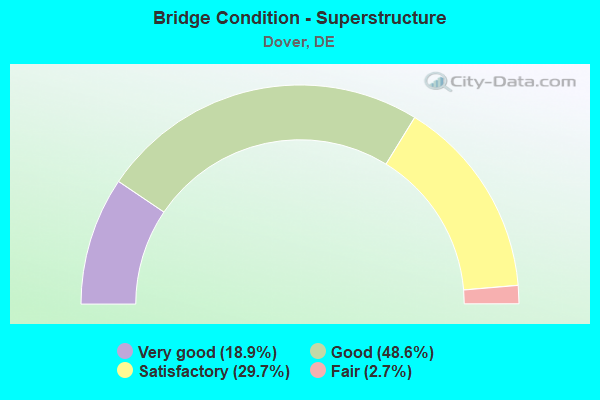
- Bridge Condition - Superstructure
- 18.9%Very good
- 48.6%Good
- 29.7%Satisfactory
- 2.7%Fair
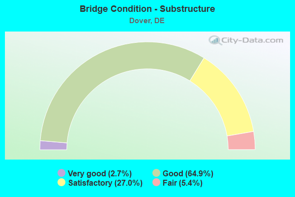
- Bridge Condition - Substructure
- 2.7%Very good
- 64.9%Good
- 27.0%Satisfactory
- 5.4%Fair
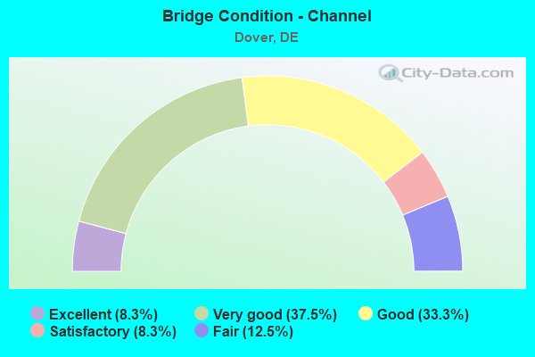
- Bridge Condition - Channel
- 8.3%Excellent
- 37.5%Very good
- 33.3%Good
- 8.3%Satisfactory
- 12.5%Fair
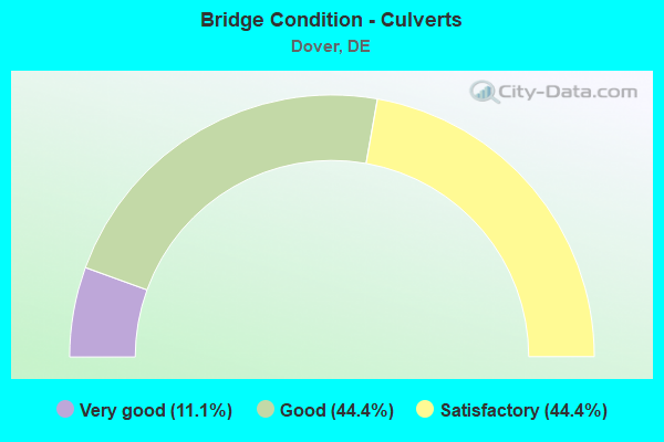
- Bridge Condition - Culverts
- 11.1%Very good
- 44.4%Good
- 44.4%Satisfactory
Find on map >> Show street view
Structure Number: 2923S15, Location: EAST OF DOVER (Lat: 39.156628, Lng: -75.493497), Route carried "on" structure: State highway 1, Year Built: 1993, Status: Open, Structure Length: 2.43m (7.97ft), Average Daily Traffic: 16,056 (year 2020), Truck Traffic: 9%, Average Future Daily Traffic: 19,956 (year 2043), Design Load: HS 20+Mod, Features Intersected: S. LITTLE CREEK RD
Minimum Vertical Clearance: 30.48m (100.00ft), Kilometerpoint: 45.818, Lanes on structure: 2, Lanes under structure: 2, Base Highway Network: Yes, Toll: On toll road, Owner: State Highway Agency, Approaching Roadway Width: 18.3m (60.0ft), Material/Design: Steel, Design/Construction: Stringer/Multi-beam, Number Of Spans In Main Unit: 1, Length of Maximum Span: 22.1m (72.5ft), Curb-To-Curb Width: 18.1m (59.4ft), Out-to-Out Width: 19.1m (62.7ft)
Condition: Deck: Good, Superstructure: Satisfactory, Substructure: Good, Operating Rating: 94.6 metric tons, Method Used To Determine Operating Rating: Load and Resistance Factor Rating (LRFR) rating reported by rating factor(RF) method using HL-93 loadings, Inventory Rating: 72.9 metric tons, Method Used To Determine Inventory Rating: Load and Resistance Factor Rating (LRFR) rating reported by rating factor(RF) method using HL-93 loadings, Structural Evaluation: Equal to present minimum criteria, Deck Geometry: Superior to present desirable criteria, Underclear: Equal to present minimum criteria, Approach Roadway Alignment: Equal to present desirable criteria, Designated Inspection Frequency: Every 24 months, Inspection Date: August 2021, Deck Structure Type: Concrete Cast-file-Place, Wearing Surface/Protective System: Wearing Surface: Monolithic Concrete, Deck Protection: Epoxy Coated Reinforcing
Find on map >> Show street view
Structure Number: 2924N15, Location: S/E DOVER (Lat: 39.142075, Lng: -75.497767), Route carried "on" structure: State highway 1, Year Built: 1993, Status: Open, Structure Length: 9.75m (31.99ft), Average Daily Traffic: 14,009 (year 2020), Truck Traffic: 9%, Average Future Daily Traffic: 17,412 (year 2043), Design Load: HS 20+Mod, Features Intersected: US 113/BAY RD
Minimum Vertical Clearance: 30.48m (100.00ft), Kilometerpoint: 2.913, Lanes on structure: 2, Lanes under structure: 4, Base Highway Network: Yes, Toll: On toll road, Owner: State Highway Agency, Approaching Roadway Width: 11.6m (38.1ft), Skew: 5 degrees, Material/Design: Steel continuous, Design/Construction: Stringer/Multi-beam, Number Of Spans In Main Unit: 2, Length of Maximum Span: 49.1m (161.1ft), Curb-To-Curb Width: 17.1m (56.1ft), Out-to-Out Width: 17.9m (58.7ft)
Condition: Deck: Good, Superstructure: Good, Substructure: Good, Operating Rating: 59.9 metric tons, Method Used To Determine Operating Rating: Load and Resistance Factor Rating (LRFR) rating reported by rating factor(RF) method using HL-93 loadings, Inventory Rating: 46.3 metric tons, Method Used To Determine Inventory Rating: Load and Resistance Factor Rating (LRFR) rating reported by rating factor(RF) method using HL-93 loadings, Structural Evaluation: Better than present minimum criteria, Deck Geometry: Superior to present desirable criteria, Underclear: Better than present minimum criteria, Approach Roadway Alignment: Equal to present desirable criteria, Designated Inspection Frequency: Every 24 months, Inspection Date: September 2021, Deck Structure Type: Concrete Cast-file-Place, Wearing Surface/Protective System: Wearing Surface: Monolithic Concrete, Deck Protection: Epoxy Coated Reinforcing
Find on map >> Show street view
Structure Number: 2924S15, Location: S.E. DOVER (Lat: 39.142439, Lng: -75.497958), Route carried "on" structure: State highway 1, Year Built: 1993, Status: Open, Structure Length: 9.75m (31.99ft), Average Daily Traffic: 14,009 (year 2020), Truck Traffic: 9%, Average Future Daily Traffic: 17,412 (year 2043), Design Load: HS 20+Mod, Features Intersected: US113 / BAY RD
Minimum Vertical Clearance: 30.48m (100.00ft), Kilometerpoint: 2.945, Lanes on structure: 2, Lanes under structure: 4, Base Highway Network: Yes, Toll: On toll road, Owner: State Highway Agency, Approaching Roadway Width: 12.3m (40.4ft), Skew: 5 degrees, Material/Design: Steel continuous, Design/Construction: Stringer/Multi-beam, Number Of Spans In Main Unit: 2, Length of Maximum Span: 49.1m (161.1ft), Curb-To-Curb Width: 14.6m (47.9ft), Out-to-Out Width: 15.4m (50.5ft)
Condition: Deck: Good, Superstructure: Satisfactory, Substructure: Good, Operating Rating: 47.0 metric tons, Method Used To Determine Operating Rating: Load and Resistance Factor Rating (LRFR) rating reported by rating factor(RF) method using HL-93 loadings, Inventory Rating: 36.3 metric tons, Method Used To Determine Inventory Rating: Load and Resistance Factor Rating (LRFR) rating reported by rating factor(RF) method using HL-93 loadings, Structural Evaluation: Equal to present minimum criteria, Deck Geometry: Superior to present desirable criteria, Underclear: Better than present minimum criteria, Approach Roadway Alignment: Equal to present desirable criteria, Designated Inspection Frequency: Every 24 months, Inspection Date: September 2021, Deck Structure Type: Concrete Cast-file-Place, Wearing Surface/Protective System: Wearing Surface: Monolithic Concrete, Deck Protection: Epoxy Coated Reinforcing
Find on map >> Show street view
Structure Number: 2925 15, Location: NORTH GATE DAFB (Lat: 39.130831, Lng: -75.492417), Route carried "on" structure: State highway 1, Year Built: 1993, Status: Open, Structure Length: 5.40m (17.72ft), Average Daily Traffic: 28,018 (year 2020), Truck Traffic: 9%, Average Future Daily Traffic: 34,824 (year 2043), Design Load: HS 20+Mod, Features Intersected: SR10/E. LEBANON RD., Facility Carried by Structure: KOREAN WAR VET MEM
Minimum Vertical Clearance: 30.48m (100.00ft), Kilometerpoint: 0.660, Lanes on structure: 5, Lanes under structure: 6, Base Highway Network: Yes, Owner: State Highway Agency, Approaching Roadway Width: 41.1m (134.8ft), Skew: 30 degrees, Material/Design: Steel continuous, Design/Construction: Stringer/Multi-beam, Number Of Spans In Main Unit: 2, Length of Maximum Span: 24.2m (79.4ft), Curb-To-Curb Width: 41.8m (137.1ft), Out-to-Out Width: 43.5m (142.7ft)
Condition: Deck: Good, Superstructure: Satisfactory, Substructure: Good, Operating Rating: 35.6 metric tons, Method Used To Determine Operating Rating: Load and Resistance Factor Rating (LRFR) rating reported by rating factor(RF) method using HL-93 loadings, Inventory Rating: 27.5 metric tons, Method Used To Determine Inventory Rating: Load and Resistance Factor Rating (LRFR) rating reported by rating factor(RF) method using HL-93 loadings, Structural Evaluation: Equal to present minimum criteria, Deck Geometry: Superior to present desirable criteria, Underclear: Equal to present minimum criteria, Approach Roadway Alignment: Equal to present desirable criteria, Designated Inspection Frequency: Every 24 months, Inspection Date: October 2021, Deck Structure Type: Concrete Cast-file-Place, Wearing Surface/Protective System: Wearing Surface: Monolithic Concrete, Deck Protection: Epoxy Coated Reinforcing
Find on map >> Show street view
Structure Number: 2926 150A, Location: S. OF ADMIN BLDG/DOVER (Lat: 39.148858, Lng: -75.495303), Route carried "on" structure: Ramp State highway 1, Year Built: 2000, Status: Open, Structure Length: 11.03m (36.19ft), Average Daily Traffic: 5,484 (year 2019), Truck Traffic: 10%, Average Future Daily Traffic: 6,816 (year 2042), Design Load: HS 25 or greater, Features Intersected: SR 1, Facility Carried by Structure: PUNCHEON RUN CONN.
Minimum Vertical Clearance: 30.48m (100.00ft), Kilometerpoint: 3.121, Lanes on structure: 1, Lanes under structure: 4, Base Highway Network: Yes, Toll: On toll road, Owner: State Highway Agency, Approaching Roadway Width: 9.8m (32.2ft), Skew: 3 degrees, Material/Design: Steel continuous, Design/Construction: Stringer/Multi-beam, Number Of Spans In Main Unit: 2, Length of Maximum Span: 55.2m (181.1ft), Curb-To-Curb Width: 10.4m (34.1ft), Out-to-Out Width: 11.2m (36.7ft)
Condition: Deck: Good, Superstructure: Good, Substructure: Good, Operating Rating: 61.2 metric tons, Method Used To Determine Operating Rating: Load and Resistance Factor Rating (LRFR) rating reported by rating factor(RF) method using HL-93 loadings, Inventory Rating: 47.3 metric tons, Method Used To Determine Inventory Rating: Load and Resistance Factor Rating (LRFR) rating reported by rating factor(RF) method using HL-93 loadings, Structural Evaluation: Better than present minimum criteria, Deck Geometry: Superior to present desirable criteria, Underclear: Superior to present desirable criteria, Approach Roadway Alignment: Equal to present desirable criteria, Designated Inspection Frequency: Every 24 months, Inspection Date: October 2020, Deck Structure Type: Concrete Cast-file-Place, Wearing Surface/Protective System: Wearing Surface: Monolithic Concrete, Deck Protection: Epoxy Coated Reinforcing
Find on map >> Show street view
Structure Number: 2929E150A, Location: S. OF ADMIN BLDG/DOVER (Lat: 39.146150, Lng: -75.500644), Route carried "on" structure: Ramp State highway 150A, Year Built: 2000, Status: Open, Structure Length: 4.98m (16.34ft), Average Daily Traffic: 7,446 (year 2019), Truck Traffic: 9%, Average Future Daily Traffic: 9,254 (year 2042), Design Load: HS 20+Mod, Features Intersected: BAY ROAD / US113, Facility Carried by Structure: PUNCHEON RUN CONN.
Minimum Vertical Clearance: 30.48m (100.00ft), Kilometerpoint: 2.590, Lanes on structure: 3, Lanes under structure: 7, Owner: State Highway Agency, Approaching Roadway Width: 14.6m (47.9ft), Material/Design: Steel continuous, Design/Construction: Stringer/Multi-beam, Number Of Spans In Main Unit: 2, Length of Maximum Span: 25.0m (82.0ft), Curb-To-Curb Width: 15.2m (49.9ft), Out-to-Out Width: 16.1m (52.8ft)
Condition: Deck: Good, Superstructure: Good, Substructure: Good, Operating Rating: 38.2 metric tons, Method Used To Determine Operating Rating: Load and Resistance Factor Rating (LRFR) rating reported by rating factor(RF) method using HL-93 loadings, Inventory Rating: 29.5 metric tons, Method Used To Determine Inventory Rating: Load and Resistance Factor Rating (LRFR) rating reported by rating factor(RF) method using HL-93 loadings, Structural Evaluation: Better than present minimum criteria, Deck Geometry: Superior to present desirable criteria, Underclear: Equal to present minimum criteria, Approach Roadway Alignment: Equal to present desirable criteria, Designated Inspection Frequency: Every 24 months, Inspection Date: September 2020, Deck Structure Type: Concrete Cast-file-Place, Wearing Surface/Protective System: Wearing Surface: Monolithic Concrete, Deck Protection: Epoxy Coated Reinforcing
Find on map >> Show street view
Structure Number: 2929W150A, Location: S. OF ADMIN BLDG/DOVER (Lat: 39.146311, Lng: -75.500786), Route carried "on" structure: Ramp County highway 150A, Year Built: 2000, Status: Open, Structure Length: 4.98m (16.34ft), Average Daily Traffic: 7,446 (year 2019), Truck Traffic: 9%, Average Future Daily Traffic: 9,254 (year 2042), Design Load: HS 20+Mod, Features Intersected: BAY ROAD, Facility Carried by Structure: PUNCHEON RUN CONN.
Minimum Vertical Clearance: 30.48m (100.00ft), Kilometerpoint: 2.590, Lanes on structure: 1, Lanes under structure: 5, Toll: On toll road, Owner: State Highway Agency, Approaching Roadway Width: 9.1m (29.9ft), Material/Design: Steel continuous, Design/Construction: Stringer/Multi-beam, Number Of Spans In Main Unit: 2, Length of Maximum Span: 25.0m (82.0ft), Curb-To-Curb Width: 9.8m (32.2ft), Out-to-Out Width: 10.6m (34.8ft)
Condition: Deck: Good, Superstructure: Good, Substructure: Satisfactory, Operating Rating: 35.3 metric tons, Method Used To Determine Operating Rating: Load and Resistance Factor Rating (LRFR) rating reported by rating factor(RF) method using HL-93 loadings, Inventory Rating: 27.2 metric tons, Method Used To Determine Inventory Rating: Load and Resistance Factor Rating (LRFR) rating reported by rating factor(RF) method using HL-93 loadings, Structural Evaluation: Equal to present minimum criteria, Deck Geometry: Superior to present desirable criteria, Underclear: Equal to present minimum criteria, Approach Roadway Alignment: Equal to present desirable criteria, Designated Inspection Frequency: Every 24 months, Inspection Date: September 2020, Deck Structure Type: Concrete Cast-file-Place, Wearing Surface/Protective System: Wearing Surface: Monolithic Concrete, Deck Protection: Epoxy Coated Reinforcing
Find on map >> Show street view
Structure Number: 2931 150A, Location: SOUTH DOVER (Lat: 39.138789, Lng: -75.522650), Route carried "on" structure: County highway 150A, Year Built: 2000, Status: Open, Structure Length: 4.00m (13.12ft), Average Daily Traffic: 10,698 (year 2019), Truck Traffic: 9%, Average Future Daily Traffic: 13,296 (year 2042), Design Load: HS 20+Mod, Features Intersected: S. STATE ST, Facility Carried by Structure: PUNCHEON RUN CONN
Minimum Vertical Clearance: 30.48m (100.00ft), Kilometerpoint: 0.515, Lanes on structure: 4, Lanes under structure: 4, Owner: State Highway Agency, Approaching Roadway Width: 32.6m (107.0ft), Skew: 33 degrees, Material/Design: Steel, Design/Construction: Stringer/Multi-beam, Number Of Spans In Main Unit: 1, Length of Maximum Span: 39.1m (128.3ft), Curb-To-Curb Width: 14.5m (47.6ft), Out-to-Out Width: 30.7m (100.7ft)
Condition: Deck: Good, Superstructure: Good, Substructure: Good, Operating Rating: 30.1 metric tons, Method Used To Determine Operating Rating: Load and Resistance Factor Rating (LRFR) rating reported by rating factor(RF) method using HL-93 loadings, Inventory Rating: 23.3 metric tons, Method Used To Determine Inventory Rating: Load and Resistance Factor Rating (LRFR) rating reported by rating factor(RF) method using HL-93 loadings, Structural Evaluation: Somewhat better than minimum adequacy, Deck Geometry: High priority of replacement, Underclear: High priority of corrective action, Approach Roadway Alignment: Equal to present desirable criteria, Length Of Structure Improvement: 4.57m (14.99ft), Designated Inspection Frequency: Every 24 months, Inspection Date: September 2020, Bridge Improvement Cost: $700,000, Roadway Improvement Cost: $100,000, Total Project Cost: $800,000, Deck Structure Type: Concrete Cast-file-Place, Wearing Surface/Protective System: Wearing Surface: Monolithic Concrete, Deck Protection: Epoxy Coated Reinforcing
Find on map >> Show street view
Structure Number: 2007B008, Location: BARKERS LANDING (Lat: 39.085294, Lng: -75.457239), Route carried "under" structure: County highway 7A, Year Built: 1984, Structure Length: 0. m, Average Daily Traffic: 1,468 (year 2020), Truck Traffic: 13%, Features Intersected: ST. JONES RIVER, Facility Carried by Structure: BAY ROAD / US113
Minimum Vertical Clearance: 6.29m (20.64ft), Kilometerpoint: 0.320, Lanes on structure: 4, Lanes under structure: 2, Material/Design: Prestressed concrete continuous, Design/Construction: Stringer/Multi-beam, Length of Maximum Span: 29.0m (95.1ft)
Find on map >> Show street view
Structure Number: 2017B017, Location: S. OF AIR FORCE BASE (Lat: 39.106306, Lng: -75.455108), Route carried "under" structure: US 113, Year Built: 2009, Structure Length: 0. m, Average Daily Traffic: 29,945 (year 2020), Truck Traffic: 9%, Features Intersected: BAY RD. / US113/SR1, Facility Carried by Structure: BAYSIDE DR. / SR9
Minimum Vertical Clearance: 5.16m (16.93ft), Kilometerpoint: 22.450, Lanes on structure: 2, Lanes under structure: 4, Material/Design: Prestressed concrete continuous, Design/Construction: Stringer/Multi-beam, Length of Maximum Span: 32.0m (105.0ft)
Find on map >> Show street view
Structure Number: 2066B066, Location: EAST OF DOVER (Lat: 39.176717, Lng: -75.502522), Route carried "under" structure: State highway 1, Year Built: 1990, Structure Length: 0. m, Average Daily Traffic: 31,198 (year 2020), Truck Traffic: 9%, Features Intersected: SR1/KOREAN WAR VET MEM, Facility Carried by Structure: RD 66 WHITE OAK RD
Minimum Vertical Clearance: 5.03m (16.50ft), Kilometerpoint: 7.145, Lanes on structure: 2, Lanes under structure: 4, Toll: On toll road, Material/Design: Steel continuous, Design/Construction: Stringer/Multi-beam, Length of Maximum Span: 33.5m (109.9ft)
Find on map >> Show street view
Structure Number: 2088B088, Location: EAST OF DOVER DOWNS (Lat: 39.192144, Lng: -75.525422), Route carried "under" structure: State highway 1, Year Built: 1993, Structure Length: 0. m, Average Daily Traffic: 31,198 (year 2020), Truck Traffic: 9%, Features Intersected: SR1/KOREAN WAR VET MEM, Facility Carried by Structure: RD 88 / LEIPSIC RD
Minimum Vertical Clearance: 5.07m (16.63ft), Kilometerpoint: 9.737, Lanes on structure: 2, Lanes under structure: 5, Toll: On toll road, Material/Design: Steel continuous, Design/Construction: Stringer/Multi-beam, Length of Maximum Span: 32.0m (105.0ft)
Find on map >> Show street view
Structure Number: 2157N151, Location: WEST DOVER (Lat: 39.130167, Lng: -75.548167), Route carried "under" structure: State highway 190, Year Built: 2017, Structure Length: 0. m, Average Daily Traffic: 4,682 (year 2020), Truck Traffic: 7%, Features Intersected: NEW BURTON RD & N/S RR, Facility Carried by Structure: POW MIA PARKWAY
Minimum Vertical Clearance: 8.10m (26.57ft), Kilometerpoint: 1.770, Lanes on structure: 2, Lanes under structure: 2, Material/Design: Prestressed concrete, Design/Construction: Stringer/Multi-beam, Length of Maximum Span: 24.2m (79.4ft)
Find on map >> Show street view
Structure Number: 2157S151, Location: WEST DOVER (Lat: 39.130056, Lng: -75.548250), Route carried "under" structure: State highway 190, Year Built: 2017, Structure Length: 0. m, Average Daily Traffic: 4,682 (year 2020), Truck Traffic: 7%, Features Intersected: NEW BURTON RD & N/S RR, Facility Carried by Structure: POW MIA PARKWAY
Minimum Vertical Clearance: 8.29m (27.20ft), Kilometerpoint: 1.770, Lanes on structure: 1, Lanes under structure: 2, Material/Design: Prestressed concrete, Design/Construction: Stringer/Multi-beam, Length of Maximum Span: 24.2m (79.4ft)
Find on map >> Show street view
Structure Number: 2357B357, Location: MAIN GATE DAFB (Lat: 39.121344, Lng: -75.479683), Route carried "under" structure: State highway 1, Year Built: 1998, Structure Length: 0. m, Average Daily Traffic: 35,243 (year 2019), Truck Traffic: 9%, Features Intersected: SR 1 N&S, Facility Carried by Structure: RD 357
Minimum Vertical Clearance: 5.09m (16.70ft), Kilometerpoint: 1.158, Lanes on structure: 3, Lanes under structure: 4, Toll: On toll road, Material/Design: Steel continuous, Design/Construction: Stringer/Multi-beam, Length of Maximum Span: 29.3m (96.1ft)
Find on map >> Show street view
Structure Number: 2920N15, Location: N.E. OF DOVER (Lat: 39.209978, Lng: -75.546822), Route carried "under" structure: County highway 331, Year Built: 1992, Structure Length: 0. m, Average Daily Traffic: 550 (year 2020), Truck Traffic: 8%, Features Intersected: RD 331/DYKE BRANCH RD, Facility Carried by Structure: KOREAN WAR VET HGW
Minimum Vertical Clearance: 5.27m (17.29ft), Kilometerpoint: 1.660, Lanes on structure: 2, Lanes under structure: 2, Material/Design: Steel, Design/Construction: Stringer/Multi-beam, Length of Maximum Span: 19.8m (65.0ft)
Find on map >> Show street view
Structure Number: 2920S15, Location: N.E. OF DOVER (Lat: 39.209811, Lng: -75.547106), Route carried "under" structure: County highway 331, Year Built: 1992, Structure Length: 0. m, Average Daily Traffic: 550 (year 2020), Truck Traffic: 8%, Features Intersected: RD 331/DYKE BRANCH RD, Facility Carried by Structure: SR1/KOREAN VET WAR
Minimum Vertical Clearance: 4.52m (14.83ft), Kilometerpoint: 1.660, Lanes on structure: 3, Lanes under structure: 2, Material/Design: Steel, Design/Construction: Stringer/Multi-beam, Length of Maximum Span: 19.8m (65.0ft)
Find on map >> Show street view
Structure Number: 2921E7046, Location: NORTH OF DOVER,TOLL PLAZA (Lat: 39.205350, Lng: -75.542972), Route carried "under" structure: State highway 1, Year Built: 1992, Structure Length: 0. m, Average Daily Traffic: 42,037 (year 2020), Truck Traffic: 9%, Features Intersected: SR1/KOREAN WAR VET MEM, Facility Carried by Structure: RAMP
Minimum Vertical Clearance: 5.19m (17.03ft), Kilometerpoint: 11.829, Lanes on structure: 1, Lanes under structure: 4, Toll: On toll road, Material/Design: Steel continuous, Design/Construction: Stringer/Multi-beam, Length of Maximum Span: 42.7m (140.1ft)
Find on map >> Show street view
Structure Number: 2921W7045, Location: NORTH OF DOVER,TOLL PLAZA (Lat: 39.205508, Lng: -75.543139), Route carried "under" structure: State highway 1, Year Built: 1992, Structure Length: 0. m, Average Daily Traffic: 42,037 (year 2020), Truck Traffic: 9%, Features Intersected: SR1/KOREAN WAR VET MEM, Facility Carried by Structure: N. DOVER TOLL RAMP
Minimum Vertical Clearance: 5.36m (17.59ft), Kilometerpoint: 11.845, Lanes on structure: 1, Lanes under structure: 4, Toll: On toll road, Material/Design: Steel continuous, Design/Construction: Stringer/Multi-beam, Length of Maximum Span: 42.7m (140.1ft)
Find on map >> Show street view
Structure Number: 2922N15, Location: EAST OF DOVER (Lat: 39.165733, Lng: -75.492875), Route carried "under" structure: State highway 8, Year Built: 1993, Structure Length: 0. m, Average Daily Traffic: 2,750 (year 2020), Truck Traffic: 7%, Features Intersected: SR8/ N. LITTLE CREEK RD, Facility Carried by Structure: SR1/KOREAN WAR VET
Minimum Vertical Clearance: 5.86m (19.23ft), Kilometerpoint: 3.219, Lanes on structure: 2, Lanes under structure: 2, Material/Design: Steel, Design/Construction: Stringer/Multi-beam, Length of Maximum Span: 30.4m (99.7ft)
Find on map >> Show street view
Structure Number: 2922S15, Location: EAST OF DOVER (Lat: 39.165753, Lng: -75.493181), Route carried "under" structure: State highway 8, Year Built: 1993, Structure Length: 0. m, Average Daily Traffic: 2,750 (year 2020), Truck Traffic: 7%, Features Intersected: SR8/ N. LITTLE CREEK RD, Facility Carried by Structure: SR1/KOREAN WAR VET
Minimum Vertical Clearance: 5.19m (17.03ft), Kilometerpoint: 3.187, Lanes on structure: 2, Lanes under structure: 2, Material/Design: Steel, Design/Construction: Stringer/Multi-beam, Length of Maximum Span: 30.4m (99.7ft)
Find on map >> Show street view
Structure Number: 2923N15, Location: EAST OF DOVER (Lat: 39.156611, Lng: -75.493122), Route carried "under" structure: County highway 67, Year Built: 1993, Structure Length: 0. m, Average Daily Traffic: 1,351 (year 2020), Truck Traffic: 7%, Features Intersected: S. LITTLE CREEK RD, Facility Carried by Structure: SR1 NB
Minimum Vertical Clearance: 4.96m (16.27ft), Kilometerpoint: 2.800, Lanes on structure: 3, Lanes under structure: 3, Material/Design: Steel, Design/Construction: Stringer/Multi-beam, Length of Maximum Span: 22.1m (72.5ft)
Find on map >> Show street view
Structure Number: 2923S15, Location: EAST OF DOVER (Lat: 39.156628, Lng: -75.493497), Route carried "under" structure: County highway 67, Year Built: 1993, Structure Length: 0. m, Average Daily Traffic: 1,351 (year 2020), Truck Traffic: 7%, Features Intersected: S. LITTLE CREEK RD, Facility Carried by Structure: SR1 SB
Minimum Vertical Clearance: 4.53m (14.86ft), Kilometerpoint: 2.820, Lanes on structure: 2, Lanes under structure: 2, Material/Design: Steel, Design/Construction: Stringer/Multi-beam, Length of Maximum Span: 22.1m (72.5ft)
Find on map >> Show street view
Structure Number: 2924N15, Location: S/E DOVER (Lat: 39.142075, Lng: -75.497767), Route carried "under" structure: US 113, Year Built: 1993, Structure Length: 0. m, Average Daily Traffic: 16,263 (year 2020), Truck Traffic: 7%, Features Intersected: US 113/BAY RD, Facility Carried by Structure: SR1/KOREAN WAR VET
Minimum Vertical Clearance: 5.18m (16.99ft), Kilometerpoint: 1.352, Lanes on structure: 2, Lanes under structure: 4, Material/Design: Steel continuous, Design/Construction: Stringer/Multi-beam, Length of Maximum Span: 49.1m (161.1ft)
Find on map >> Show street view
Structure Number: 2924S15, Location: S.E. DOVER (Lat: 39.142439, Lng: -75.497958), Route carried "under" structure: US 113, Year Built: 1993, Structure Length: 0. m, Average Daily Traffic: 16,263 (year 2020), Truck Traffic: 6%, Features Intersected: US113 / BAY RD, Facility Carried by Structure: SR1/KOREAN WAR VET
Minimum Vertical Clearance: 5.56m (18.24ft), Kilometerpoint: 1.400, Lanes on structure: 2, Lanes under structure: 4, Material/Design: Steel continuous, Design/Construction: Stringer/Multi-beam, Length of Maximum Span: 49.1m (161.1ft)
Find on map >> Show street view
Structure Number: 2925 15, Location: NORTH GATE DAFB (Lat: 39.130831, Lng: -75.492417), Route carried "under" structure: State highway 10, Year Built: 1993, Structure Length: 0. m, Average Daily Traffic: 15,371 (year 2020), Truck Traffic: 7%, Features Intersected: SR10/E. LEBANON RD., Facility Carried by Structure: KOREAN WAR VET MEM
Minimum Vertical Clearance: 5.27m (17.29ft), Kilometerpoint: 4.522, Lanes on structure: 5, Lanes under structure: 5, Material/Design: Steel continuous, Design/Construction: Stringer/Multi-beam, Length of Maximum Span: 24.2m (79.4ft)
Find on map >> Show street view
Structure Number: 2926 150A, Location: S. OF ADMIN BLDG/DOVER (Lat: 39.148858, Lng: -75.495303), Route carried "under" structure: State highway 1, Year Built: 2000, Structure Length: 0. m, Average Daily Traffic: 40,393 (year 2019), Truck Traffic: 10%, Features Intersected: SR 1, Facility Carried by Structure: PUNCHEON RUN CONN.
Minimum Vertical Clearance: 6.21m (20.37ft), Kilometerpoint: 3.121, Lanes on structure: 1, Lanes under structure: 4, Toll: On toll road, Material/Design: Steel continuous, Design/Construction: Stringer/Multi-beam, Length of Maximum Span: 55.2m (181.1ft)
Find on map >> Show street view
Structure Number: 2929E150A, Location: S. OF ADMIN BLDG/DOVER (Lat: 39.146150, Lng: -75.500644), Route carried "under" structure: US 113, Year Built: 2000, Structure Length: 0. m, Average Daily Traffic: 28,393 (year 2019), Truck Traffic: 9%, Features Intersected: BAY ROAD / US113, Facility Carried by Structure: PUNCHEON RUN CONN.
Minimum Vertical Clearance: 5.90m (19.36ft), Kilometerpoint: 1.867, Lanes on structure: 3, Lanes under structure: 7, Material/Design: Steel continuous, Design/Construction: Stringer/Multi-beam, Length of Maximum Span: 25.0m (82.0ft)
Find on map >> Show street view
Structure Number: 2929W150A, Location: S. OF ADMIN BLDG/DOVER (Lat: 39.146311, Lng: -75.500786), Route carried "under" structure: US 113, Year Built: 2000, Structure Length: 0. m, Average Daily Traffic: 28,383 (year 2019), Truck Traffic: 9%, Features Intersected: BAY ROAD, Facility Carried by Structure: PUNCHEON RUN CONN.
Minimum Vertical Clearance: 6.00m (19.69ft), Kilometerpoint: 1.867, Lanes on structure: 1, Lanes under structure: 5, Material/Design: Steel continuous, Design/Construction: Stringer/Multi-beam, Length of Maximum Span: 25.0m (82.0ft)
Find on map >> Show street view
Structure Number: 2931 150A, Location: SOUTH DOVER (Lat: 39.138789, Lng: -75.522650), Route carried "under" structure: Alternate State highway 113A, Year Built: 2000, Structure Length: 0. m, Average Daily Traffic: 4,852 (year 2019), Truck Traffic: 8%, Features Intersected: S. STATE ST, Facility Carried by Structure: PUNCHEON RUN CONN
Minimum Vertical Clearance: 5.36m (17.59ft), Kilometerpoint: 0.515, Lanes on structure: 4, Lanes under structure: 4, Material/Design: Steel, Design/Construction: Stringer/Multi-beam, Length of Maximum Span: 39.1m (128.3ft)