Bridge Statistics for Dubuque, Iowa (IA)
Condition, Traffic, Stress, Structural Evaluation, Project Costs
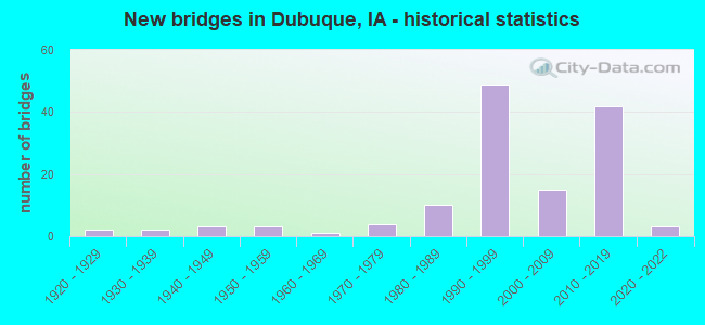
- New bridges - historical statistics
- 21920-1929
- 21930-1939
- 31940-1949
- 31950-1959
- 11960-1969
- 41970-1979
- 101980-1989
- 491990-1999
- 152000-2009
- 422010-2019
- 32020-2022
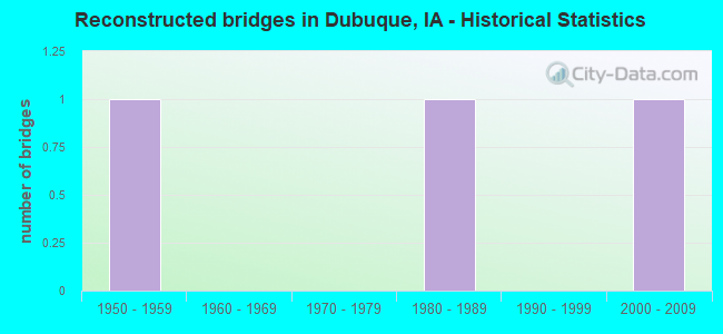
- Reconstructed bridges - Historical Statistics
- 11950-1959
- 01960-1969
- 01970-1979
- 11980-1989
- 01990-1999
- 12000-2009
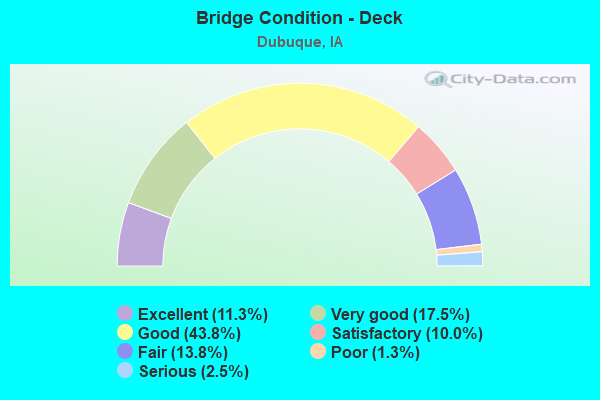
- Bridge Condition - Deck
- 11.3%Excellent
- 17.5%Very good
- 43.8%Good
- 10.0%Satisfactory
- 13.8%Fair
- 1.3%Poor
- 2.5%Serious
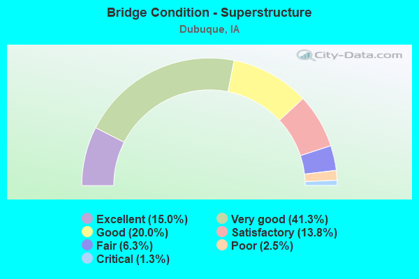
- Bridge Condition - Superstructure
- 15.0%Excellent
- 41.3%Very good
- 20.0%Good
- 13.8%Satisfactory
- 6.3%Fair
- 2.5%Poor
- 1.3%Critical

- Bridge Condition - Substructure
- 15.0%Excellent
- 27.5%Very good
- 38.8%Good
- 10.0%Satisfactory
- 5.0%Fair
- 2.5%Poor
- 1.3%Critical
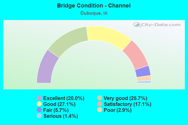
- Bridge Condition - Channel
- 20.0%Excellent
- 25.7%Very good
- 27.1%Good
- 17.1%Satisfactory
- 5.7%Fair
- 2.9%Poor
- 1.4%Serious
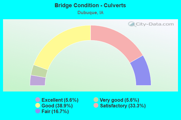
- Bridge Condition - Culverts
- 5.6%Excellent
- 5.6%Very good
- 38.9%Good
- 33.3%Satisfactory
- 16.7%Fair
Find on map >> Show street view
Structure Number: 60777, Location: 1.9 mi. S of Jct. IA 3 (Lat: 42.525911, Lng: -90.722519), Route carried "on" structure: City street , Year Built: 2002, Status: Open, Structure Length: 3.75m (12.30ft), Average Daily Traffic: 2,950 (year 2021), Average Future Daily Traffic: 2,950 (year 2041), Design Load: HS 20, Features Intersected: WEST 32ND STREET, Facility Carried by Structure: NW ARTERIAL NB
Minimum Vertical Clearance: 30+ m (98+ ft), Kilometerpoint: 5.089, Lanes on structure: 2, Lanes under structure: 2, Base Highway Network: Yes, Owner: City or Municipal Highway Agency, Approaching Roadway Width: 12.2m (40.0ft), Skew: 21 degrees, Material/Design: Prestressed concrete, Design/Construction: Stringer/Multi-beam, Number Of Spans In Main Unit: 1, Length of Maximum Span: 36.6m (120.1ft), Curb-To-Curb Width: 12.0m (39.4ft), Out-to-Out Width: 14.2m (46.6ft)
Condition: Deck: Good, Superstructure: Very good, Substructure: Very good, Operating Rating: 90.5 metric tons, Method Used To Determine Operating Rating: Load Factor (LF), Inventory Rating: 44.3 metric tons, Method Used To Determine Inventory Rating: Load Factor (LF), Structural Evaluation: Equal to present desirable criteria, Deck Geometry: Better than present minimum criteria, Underclear: High priority of corrective action, Approach Roadway Alignment: Equal to present desirable criteria, Designated Inspection Frequency: Every 24 months, Inspection Date: November 2021, Deck Structure Type: Concrete Cast-file-Place, Wearing Surface/Protective System: Wearing Surface: Monolithic Concrete, Deck Protection: Epoxy Coated Reinforcing
Find on map >> Show street view
Structure Number: 607775, Location: 1.9 mi. S of Jct. IA 3 (Lat: 42.526172, Lng: -90.722181), Route carried "on" structure: City street , Year Built: 2002, Status: Open, Structure Length: 3.75m (12.30ft), Average Daily Traffic: 3,400 (year 2021), Average Future Daily Traffic: 3,400 (year 2041), Design Load: HS 20, Features Intersected: WEST 32ND STREET, Facility Carried by Structure: NW ARTERIAL SB
Minimum Vertical Clearance: 30+ m (98+ ft), Kilometerpoint: 1.967, Lanes on structure: 2, Lanes under structure: 2, Owner: City or Municipal Highway Agency, Approaching Roadway Width: 12.2m (40.0ft), Skew: 21 degrees, Material/Design: Prestressed concrete, Design/Construction: Stringer/Multi-beam, Number Of Spans In Main Unit: 1, Length of Maximum Span: 36.6m (120.1ft), Curb-To-Curb Width: 12.0m (39.4ft), Out-to-Out Width: 14.2m (46.6ft)
Condition: Deck: Very good, Superstructure: Very good, Substructure: Very good, Operating Rating: 90.5 metric tons, Method Used To Determine Operating Rating: Load Factor (LF), Inventory Rating: 44.3 metric tons, Method Used To Determine Inventory Rating: Load Factor (LF), Structural Evaluation: Equal to present desirable criteria, Deck Geometry: Better than present minimum criteria, Underclear: High priority of corrective action, Approach Roadway Alignment: Equal to present desirable criteria, Designated Inspection Frequency: Every 24 months, Inspection Date: November 2021, Deck Structure Type: Concrete Cast-file-Place, Wearing Surface/Protective System: Wearing Surface: Monolithic Concrete, Deck Protection: Epoxy Coated Reinforcing
Find on map >> Show street view
Structure Number: 69976, Location: IN MINES OF SPAIN ST. PK. (Lat: 42.466367, Lng: -90.647897), Route carried "on" structure: State lands road , Year Built: 1993, Status: Open, Structure Length: 4.42m (14.50ft), Design Load: HS 20, Features Intersected: CATFISH CREEK, Facility Carried by Structure: MINES OF SPAIN
Minimum Vertical Clearance: 30+ m (98+ ft), Kilometerpoint: 1.487, Lanes on structure: 2, Owner: State Highway Agency, Maintenance Responsibility: State Park, Forest, or Reservation Agency, Approaching Roadway Width: 9.8m (32.2ft), Material/Design: Prestressed concrete, Design/Construction: Stringer/Multi-beam, Number Of Spans In Main Unit: 3, Length of Maximum Span: 17.1m (56.1ft), Curb-To-Curb Width: 10.0m (32.8ft), Out-to-Out Width: 12.1m (39.7ft)
Condition: Deck: Good, Superstructure: Very good, Substructure: Good, Channel: Very good, Operating Rating: 67.6 metric tons, Method Used To Determine Operating Rating: Load Factor (LF), Inventory Rating: 40.5 metric tons, Method Used To Determine Inventory Rating: Load Factor (LF), Structural Evaluation: Better than present minimum criteria, Deck Geometry: Superior to present desirable criteria, Waterway Adequacy: Equal to present minimum criteria, Approach Roadway Alignment: Somewhat better than minimum adequacy, Designated Inspection Frequency: Every 24 months, Underwater Inspection Frequency: Every 72 months, Inspection Date: April 2021, Underwater Inspection Date: July 2019, Deck Structure Type: Concrete Cast-file-Place, Wearing Surface/Protective System: Wearing Surface: Monolithic Concrete, Deck Protection: Epoxy Coated Reinforcing
Find on map >> Show street view
Structure Number: 70016, Location: 0.7 MI S of Grandview Av (Lat: 42.468461, Lng: -90.668567), Route carried "on" structure: US 61, Year Built: 2014, Status: Open, Structure Length: 16.01m (52.53ft), Average Daily Traffic: 8,900 (year 2020), Truck Traffic: 17%, Average Future Daily Traffic: 8,900 (year 2041), Design Load: HL 93, Features Intersected: CATFISH CR, RR & RD
Minimum Vertical Clearance: 30+ m (98+ ft), Kilometerpoint: 7.044, Lanes on structure: 2, Lanes under structure: 2, Owner: State Highway Agency, Approaching Roadway Width: 12.5m (41.0ft), Skew: 3 degrees, Material/Design: Prestressed concrete, Design/Construction: Stringer/Multi-beam, Number Of Spans In Main Unit: 5, Length of Maximum Span: 35.7m (117.1ft), Curb-To-Curb Width: 12.2m (40.0ft), Out-to-Out Width: 13.2m (43.3ft)
Condition: Deck: Very good, Superstructure: Very good, Substructure: Very good, Channel: Excellent, Operating Rating: 42.1 metric tons, Method Used To Determine Operating Rating: Assigned ratings based on Load and Resistance Factor Design (LRFD) reported by rating factor (RF) using HL93 loadings, Inventory Rating: 32.4 metric tons, Method Used To Determine Inventory Rating: Assigned ratings based on Load and Resistance Factor Design (LRFD) reported by rating factor (RF) using HL93 loadings, Structural Evaluation: Equal to present desirable criteria, Deck Geometry: Better than present minimum criteria, Underclear: Superior to present desirable criteria, Waterway Adequacy: Superior to present desirable criteria, Approach Roadway Alignment: Equal to present desirable criteria, Designated Inspection Frequency: Every 24 months, Inspection Date: January 2021, Deck Structure Type: Concrete Cast-file-Place, Wearing Surface/Protective System: Wearing Surface: Monolithic Concrete, Deck Protection: Epoxy Coated Reinforcing
Find on map >> Show street view
Structure Number: 700165, Location: 0.7 MI S of Grandview Av (Lat: 42.467283, Lng: -90.668864), Route carried "on" structure: US 61, Year Built: 2014, Status: Open, Structure Length: 16.01m (52.53ft), Average Daily Traffic: 9,000 (year 2020), Truck Traffic: 17%, Average Future Daily Traffic: 9,000 (year 2041), Design Load: HL 93, Features Intersected: CATFISH CR, RR & RD
Minimum Vertical Clearance: 30+ m (98+ ft), Kilometerpoint: 302.962, Lanes on structure: 2, Lanes under structure: 2, Base Highway Network: Yes, Owner: State Highway Agency, Approaching Roadway Width: 12.5m (41.0ft), Skew: 3 degrees, Material/Design: Prestressed concrete, Design/Construction: Stringer/Multi-beam, Number Of Spans In Main Unit: 5, Length of Maximum Span: 35.7m (117.1ft), Curb-To-Curb Width: 12.2m (40.0ft), Out-to-Out Width: 13.2m (43.3ft)
Condition: Deck: Good, Superstructure: Very good, Substructure: Very good, Channel: Excellent, Operating Rating: 42.1 metric tons, Method Used To Determine Operating Rating: Assigned ratings based on Load and Resistance Factor Design (LRFD) reported by rating factor (RF) using HL93 loadings, Inventory Rating: 32.4 metric tons, Method Used To Determine Inventory Rating: Assigned ratings based on Load and Resistance Factor Design (LRFD) reported by rating factor (RF) using HL93 loadings, Structural Evaluation: Equal to present desirable criteria, Deck Geometry: Better than present minimum criteria, Underclear: Superior to present desirable criteria, Waterway Adequacy: Superior to present desirable criteria, Approach Roadway Alignment: Equal to present desirable criteria, Designated Inspection Frequency: Every 24 months, Inspection Date: January 2021, Deck Structure Type: Concrete Cast-file-Place, Wearing Surface/Protective System: Wearing Surface: Monolithic Concrete, Deck Protection: Epoxy Coated Reinforcing
Find on map >> Show street view
Structure Number: 700775, Location: 1.5 MI. S OF DUBUQUE (Lat: 42.433917, Lng: -90.681233), Route carried "on" structure: US 52, Year Built: 2019, Status: Open, Structure Length: 1.18m (3.87ft), Average Daily Traffic: 1,920 (year 2020), Truck Traffic: 9%, Average Future Daily Traffic: 1,920 (year 2040), Design Load: HL 93, Features Intersected: GRANGER CREEK
Minimum Vertical Clearance: 30+ m (98+ ft), Kilometerpoint: 206.244, Lanes on structure: 2, Owner: State Highway Agency, Approaching Roadway Width: 7.9m (25.9ft), Skew: 1 degrees, Material/Design: Concrete, Design/Construction: Culvert, Number Of Spans In Main Unit: 3, Length of Maximum Span: 3.7m (12.1ft)
Condition: Channel: Excellent, Culverts: Excellent, Operating Rating: 85.5 metric tons, Method Used To Determine Operating Rating: Load and Resistance Factor Rating (LRFR) rating reported by rating factor(RF) method using HL-93 loadings, Inventory Rating: 66.1 metric tons, Method Used To Determine Inventory Rating: Load and Resistance Factor Rating (LRFR) rating reported by rating factor(RF) method using HL-93 loadings, Structural Evaluation: Superior to present desirable criteria, Waterway Adequacy: Superior to present desirable criteria, Approach Roadway Alignment: Equal to present desirable criteria, Designated Inspection Frequency: Every 24 months, Inspection Date: May 2020
Find on map >> Show street view
Structure Number: 700785, Location: 0.7 MI. E. OF US 20 (Lat: 42.469822, Lng: -90.750783), Route carried "on" structure: County highway , Year Built: 2017, Status: Open, Structure Length: 8.69m (28.51ft), Average Daily Traffic: 640 (year 2017), Truck Traffic: 13%, Average Future Daily Traffic: 640 (year 2042), Design Load: HL 93, Features Intersected: US 52, Facility Carried by Structure: ENGLISH MILL RD
Minimum Vertical Clearance: 30+ m (98+ ft), Kilometerpoint: 2.145, Lanes on structure: 2, Lanes under structure: 4, Owner: State Highway Agency, Approaching Roadway Width: 12.2m (40.0ft), Skew: 1 degrees, Material/Design: Prestressed concrete, Design/Construction: Stringer/Multi-beam, Number Of Spans In Main Unit: 2, Length of Maximum Span: 44.5m (146.0ft), Curb or Sidewalk Widths: Left: 4.4m (14.4ft), Right: 0.0m, Curb-To-Curb Width: 12.2m (40.0ft), Out-to-Out Width: 17.8m (58.4ft)
Condition: Deck: Good, Superstructure: Very good, Substructure: Very good, Operating Rating: 42.1 metric tons, Method Used To Determine Operating Rating: Assigned ratings based on Load and Resistance Factor Design (LRFD) reported by rating factor (RF) using HL93 loadings, Inventory Rating: 32.4 metric tons, Method Used To Determine Inventory Rating: Assigned ratings based on Load and Resistance Factor Design (LRFD) reported by rating factor (RF) using HL93 loadings, Structural Evaluation: Equal to present desirable criteria, Deck Geometry: Equal to present desirable criteria, Underclear: Equal to present desirable criteria, Approach Roadway Alignment: Equal to present desirable criteria, Designated Inspection Frequency: Every 24 months, Inspection Date: January 2022, Deck Structure Type: Concrete Cast-file-Place, Wearing Surface/Protective System: Wearing Surface: Monolithic Concrete, Deck Protection: Epoxy Coated Reinforcing
Find on map >> Show street view
Structure Number: 70083, Location: MILITARY RD INTERSECTION (Lat: 42.446061, Lng: -90.692100), Route carried "on" structure: County highway , Year Built: 2017, Status: Open, Structure Length: 11.13m (36.52ft), Average Daily Traffic: 1,850 (year 2021), Truck Traffic: 9%, Average Future Daily Traffic: 1,850 (year 2040), Design Load: HL 93, Features Intersected: US 52, Facility Carried by Structure: MILITARY RD
Minimum Vertical Clearance: 30+ m (98+ ft), Kilometerpoint: 4.826, Lanes on structure: 2, Lanes under structure: 4, Owner: State Highway Agency, Approaching Roadway Width: 9.4m (30.8ft), Skew: 4 degrees, Material/Design: Prestressed concrete, Design/Construction: Stringer/Multi-beam, Number Of Spans In Main Unit: 4, Length of Maximum Span: 33.8m (110.9ft), Curb or Sidewalk Widths: Left: 3.7m (12.1ft), Right: 0.0m, Curb-To-Curb Width: 9.4m (30.8ft), Out-to-Out Width: 14.4m (47.2ft)
Condition: Deck: Excellent, Superstructure: Excellent, Substructure: Excellent, Operating Rating: 42.1 metric tons, Method Used To Determine Operating Rating: Assigned ratings based on Load and Resistance Factor Design (LRFD) reported by rating factor (RF) using HL93 loadings, Inventory Rating: 32.4 metric tons, Method Used To Determine Inventory Rating: Assigned ratings based on Load and Resistance Factor Design (LRFD) reported by rating factor (RF) using HL93 loadings, Structural Evaluation: Equal to present desirable criteria, Deck Geometry: Somewhat better than minimum adequacy, Underclear: Superior to present desirable criteria, Approach Roadway Alignment: Equal to present desirable criteria, Designated Inspection Frequency: Every 24 months, Inspection Date: May 2020, Deck Structure Type: Concrete Cast-file-Place, Wearing Surface/Protective System: Wearing Surface: Monolithic Concrete, Deck Protection: Epoxy Coated Reinforcing
Find on map >> Show street view
Structure Number: 700835, Location: IA 32 OVER US20 IN DUBUQU (Lat: 42.474581, Lng: -90.760478), Route carried "on" structure: US 52, Year Built: 2019, Status: Open, Structure Length: 20.09m (65.91ft), Average Daily Traffic: 7,200 (year 2020), Truck Traffic: 9%, Average Future Daily Traffic: 7,200 (year 2040), Design Load: HL 93, Features Intersected: US 20
Minimum Vertical Clearance: 30+ m (98+ ft), Kilometerpoint: 82.334, Lanes on structure: 5, Lanes under structure: 4, Base Highway Network: Yes, Owner: State Highway Agency, Approaching Roadway Width: 8.5m (27.9ft), Skew: 10 degrees, Material/Design: Prestressed concrete, Design/Construction: Stringer/Multi-beam, Number Of Spans In Main Unit: 5, Length of Maximum Span: 47.9m (157.2ft), Curb or Sidewalk Widths: Left: 0.0m, Right: 4.3m (14.1ft), Curb-To-Curb Width: 23.2m (76.1ft), Out-to-Out Width: 28.7m (94.2ft)
Condition: Deck: Excellent, Superstructure: Excellent, Substructure: Excellent, Channel: Excellent, Operating Rating: 42.1 metric tons, Method Used To Determine Operating Rating: Assigned ratings based on Load and Resistance Factor Design (LRFD) reported by rating factor (RF) using HL93 loadings, Inventory Rating: 32.4 metric tons, Method Used To Determine Inventory Rating: Assigned ratings based on Load and Resistance Factor Design (LRFD) reported by rating factor (RF) using HL93 loadings, Structural Evaluation: Equal to present desirable criteria, Deck Geometry: Better than present minimum criteria, Underclear: Equal to present minimum criteria, Waterway Adequacy: Superior to present desirable criteria, Approach Roadway Alignment: Equal to present desirable criteria, Designated Inspection Frequency: Every 24 months, Inspection Date: May 2020, Deck Structure Type: Concrete Cast-file-Place, Wearing Surface/Protective System: Wearing Surface: Monolithic Concrete, Deck Protection: Epoxy Coated Reinforcing
Find on map >> Show street view
Structure Number: 70084, Location: US 20 & IA 32 SW ARTERIAL (Lat: 42.474794, Lng: -90.759483), Route carried "on" structure: Ramp US 20, Year Built: 2019, Status: Open, Structure Length: 7.25m (23.79ft), Average Daily Traffic: 1,310 (year 2020), Truck Traffic: 9%, Average Future Daily Traffic: 1,310 (year 2040), Design Load: HL 93, Features Intersected: S FORK CATFISH CREEK
Minimum Vertical Clearance: 30+ m (98+ ft), Kilometerpoint: 0.076, Lanes on structure: 1, Owner: State Highway Agency, Approaching Roadway Width: 8.5m (27.9ft), Skew: 1 degrees, Material/Design: Prestressed concrete, Design/Construction: Stringer/Multi-beam, Number Of Spans In Main Unit: 3, Length of Maximum Span: 24.9m (81.7ft), Curb-To-Curb Width: 8.5m (27.9ft), Out-to-Out Width: 9.5m (31.2ft)
Condition: Deck: Excellent, Superstructure: Excellent, Substructure: Excellent, Channel: Excellent, Operating Rating: 42.1 metric tons, Method Used To Determine Operating Rating: Assigned ratings based on Load and Resistance Factor Design (LRFD) reported by rating factor (RF) using HL93 loadings, Inventory Rating: 32.4 metric tons, Method Used To Determine Inventory Rating: Assigned ratings based on Load and Resistance Factor Design (LRFD) reported by rating factor (RF) using HL93 loadings, Structural Evaluation: Equal to present desirable criteria, Deck Geometry: Superior to present desirable criteria, Waterway Adequacy: Superior to present desirable criteria, Approach Roadway Alignment: Equal to present desirable criteria, Designated Inspection Frequency: Every 24 months, Inspection Date: March 2020, Deck Structure Type: Concrete Cast-file-Place, Wearing Surface/Protective System: Wearing Surface: Monolithic Concrete, Deck Protection: Epoxy Coated Reinforcing
Find on map >> Show street view
Structure Number: 700845, Location: US 20 & IA 32 SW ARTERIAL (Lat: 42.475178, Lng: -90.763461), Route carried "on" structure: Ramp US 52, Year Built: 2018, Status: Open, Structure Length: 6.99m (22.93ft), Average Daily Traffic: 710 (year 2020), Truck Traffic: 9%, Average Future Daily Traffic: 710 (year 2040), Design Load: HL 93, Features Intersected: S FORK CATFISH CREEK, Facility Carried by Structure: US 20 ON RAMP
Minimum Vertical Clearance: 30+ m (98+ ft), Kilometerpoint: 82.683, Lanes on structure: 1, Base Highway Network: Yes, Owner: State Highway Agency, Approaching Roadway Width: 8.5m (27.9ft), Skew: 1 degrees, Material/Design: Prestressed concrete, Design/Construction: Stringer/Multi-beam, Number Of Spans In Main Unit: 3, Length of Maximum Span: 24.8m (81.4ft), Curb-To-Curb Width: 8.5m (27.9ft), Out-to-Out Width: 9.5m (31.2ft)
Condition: Deck: Excellent, Superstructure: Excellent, Substructure: Excellent, Channel: Excellent, Operating Rating: 42.1 metric tons, Method Used To Determine Operating Rating: Assigned ratings based on Load and Resistance Factor Design (LRFD) reported by rating factor (RF) using HL93 loadings, Inventory Rating: 32.4 metric tons, Method Used To Determine Inventory Rating: Assigned ratings based on Load and Resistance Factor Design (LRFD) reported by rating factor (RF) using HL93 loadings, Structural Evaluation: Equal to present desirable criteria, Deck Geometry: Superior to present desirable criteria, Waterway Adequacy: Superior to present desirable criteria, Approach Roadway Alignment: Equal to present desirable criteria, Designated Inspection Frequency: Every 24 months, Inspection Date: March 2020, Deck Structure Type: Concrete Cast-file-Place, Wearing Surface/Protective System: Wearing Surface: Monolithic Concrete, Deck Protection: Epoxy Coated Reinforcing
Find on map >> Show street view
Structure Number: 700905, Location: IA 32 OVER CATFISH CREEK (Lat: 42.456125, Lng: -90.703456), Route carried "on" structure: US 52, Year Built: 2019, Status: Open, Structure Length: 20.39m (66.90ft), Average Daily Traffic: 3,100 (year 2020), Truck Traffic: 9%, Average Future Daily Traffic: 3,100 (year 2040), Design Load: HL 93, Features Intersected: CATFISH CREEK
Minimum Vertical Clearance: 30+ m (98+ ft), Kilometerpoint: 77.197, Lanes on structure: 2, Base Highway Network: Yes, Owner: State Highway Agency, Approaching Roadway Width: 13.4m (44.0ft), Material/Design: Prestressed concrete, Design/Construction: Stringer/Multi-beam, Number Of Spans In Main Unit: 5, Length of Maximum Span: 41.8m (137.1ft), Curb or Sidewalk Widths: Left: 0.0m, Right: 4.3m (14.1ft), Curb-To-Curb Width: 13.4m (44.0ft), Out-to-Out Width: 18.7m (61.4ft)
Condition: Deck: Excellent, Superstructure: Excellent, Substructure: Excellent, Channel: Excellent, Operating Rating: 42.1 metric tons, Method Used To Determine Operating Rating: Assigned ratings based on Load and Resistance Factor Design (LRFD) reported by rating factor (RF) using HL93 loadings, Inventory Rating: 32.4 metric tons, Method Used To Determine Inventory Rating: Assigned ratings based on Load and Resistance Factor Design (LRFD) reported by rating factor (RF) using HL93 loadings, Structural Evaluation: Equal to present desirable criteria, Deck Geometry: Superior to present desirable criteria, Waterway Adequacy: Superior to present desirable criteria, Approach Roadway Alignment: Equal to present desirable criteria, Designated Inspection Frequency: Every 24 months, Inspection Date: August 2020, Deck Structure Type: Concrete Cast-file-Place, Wearing Surface/Protective System: Wearing Surface: Monolithic Concrete, Deck Protection: Epoxy Coated Reinforcing
Find on map >> Show street view
Structure Number: 700925, Location: US 61/151 & IA 32 INTER. (Lat: 42.433731, Lng: -90.684828), Route carried "on" structure: US 52, Year Built: 2019, Status: Open, Structure Length: 17.24m (56.56ft), Average Daily Traffic: 7,300 (year 2020), Truck Traffic: 9%, Average Future Daily Traffic: 7,300 (year 2040), Design Load: HL 93, Features Intersected: US 61/151 GRANGER CREEK
Minimum Vertical Clearance: 30+ m (98+ ft), Kilometerpoint: 205.759, Lanes on structure: 3, Lanes under structure: 4, Owner: State Highway Agency, Approaching Roadway Width: 16.8m (55.1ft), Skew: 20 degrees, Material/Design: Steel continuous, Design/Construction: Stringer/Multi-beam, Number Of Spans In Main Unit: 4, Length of Maximum Span: 62.5m (205.1ft), Curb or Sidewalk Widths: Left: 0.0m, Right: 4.3m (14.1ft), Curb-To-Curb Width: 16.8m (55.1ft), Out-to-Out Width: 22.3m (73.2ft)
Condition: Deck: Very good, Superstructure: Excellent, Substructure: Excellent, Channel: Excellent, Operating Rating: 42.1 metric tons, Method Used To Determine Operating Rating: Assigned ratings based on Load and Resistance Factor Design (LRFD) reported by rating factor (RF) using HL93 loadings, Inventory Rating: 32.4 metric tons, Method Used To Determine Inventory Rating: Assigned ratings based on Load and Resistance Factor Design (LRFD) reported by rating factor (RF) using HL93 loadings, Structural Evaluation: Equal to present desirable criteria, Deck Geometry: Superior to present desirable criteria, Underclear: Equal to present minimum criteria, Waterway Adequacy: Superior to present desirable criteria, Approach Roadway Alignment: Equal to present desirable criteria, Designated Inspection Frequency: Every 24 months, Inspection Date: May 2020, Deck Structure Type: Concrete Cast-file-Place, Wearing Surface/Protective System: Wearing Surface: Monolithic Concrete, Deck Protection: Epoxy Coated Reinforcing
Find on map >> Show street view
Structure Number: 700935, Location: 0.2 MI. S. OF SEIPPEL RD. (Lat: 42.473397, Lng: -90.766819), Route carried "on" structure: City street , Year Built: 2019, Status: Open, Structure Length: 4.51m (14.80ft), Average Daily Traffic: 101 (year 2020), Average Future Daily Traffic: 101 (year 2041), Design Load: HL 93, Features Intersected: S FORK CATFISH CREEK, Facility Carried by Structure: AIRBORNE ROAD
Minimum Vertical Clearance: 30+ m (98+ ft), Kilometerpoint: 0.864, Lanes on structure: 2, Owner: City or Municipal Highway Agency, Approaching Roadway Width: 11.3m (37.1ft), Skew: 1 degrees, Material/Design: Prestressed concrete, Design/Construction: Stringer/Multi-beam, Number Of Spans In Main Unit: 1, Length of Maximum Span: 44.2m (145.0ft), Curb-To-Curb Width: 11.3m (37.1ft), Out-to-Out Width: 12.3m (40.4ft)
Condition: Deck: Very good, Superstructure: Excellent, Substructure: Excellent, Channel: Excellent, Operating Rating: 42.1 metric tons, Method Used To Determine Operating Rating: Assigned ratings based on Load and Resistance Factor Design (LRFD) reported by rating factor (RF) using HL93 loadings, Inventory Rating: 32.4 metric tons, Method Used To Determine Inventory Rating: Assigned ratings based on Load and Resistance Factor Design (LRFD) reported by rating factor (RF) using HL93 loadings, Structural Evaluation: Equal to present desirable criteria, Deck Geometry: Superior to present desirable criteria, Waterway Adequacy: Superior to present desirable criteria, Approach Roadway Alignment: Equal to present desirable criteria, Designated Inspection Frequency: Every 24 months, Inspection Date: November 2021, Deck Structure Type: Concrete Cast-file-Place, Wearing Surface/Protective System: Wearing Surface: Monolithic Concrete, Deck Protection: Epoxy Coated Reinforcing
Find on map >> Show street view
Structure Number: 70094, Location: US 61 CONNECTOR (Lat: 42.428447, Lng: -90.688592), Route carried "on" structure: Ramp County highway , Year Built: 2019, Status: Open, Structure Length: 8.12m (26.64ft), Average Daily Traffic: 1,240 (year 2021), Truck Traffic: 21%, Average Future Daily Traffic: 1,240 (year 2040), Design Load: HL 93, Features Intersected: GRANGER CREEK, Facility Carried by Structure: US 61 OFF RAMP
Minimum Vertical Clearance: 30+ m (98+ ft), Kilometerpoint: 0.562, Lanes on structure: 2, Owner: County Highway Agency, Approaching Roadway Width: 11.0m (36.1ft), Material/Design: Steel continuous, Design/Construction: Stringer/Multi-beam, Number Of Spans In Main Unit: 3, Length of Maximum Span: 33.5m (109.9ft), Curb-To-Curb Width: 11.0m (36.1ft), Out-to-Out Width: 11.9m (39.0ft)
Condition: Deck: Excellent, Superstructure: Excellent, Substructure: Excellent, Channel: Excellent, Operating Rating: 46.3 metric tons, Method Used To Determine Operating Rating: Assigned ratings based on Load and Resistance Factor Design (LRFD) reported by rating factor (RF) using HL93 loadings, Inventory Rating: 35.6 metric tons, Method Used To Determine Inventory Rating: Assigned ratings based on Load and Resistance Factor Design (LRFD) reported by rating factor (RF) using HL93 loadings, Structural Evaluation: Superior to present desirable criteria, Deck Geometry: Better than present minimum criteria, Waterway Adequacy: Superior to present desirable criteria, Approach Roadway Alignment: Equal to present desirable criteria, Designated Inspection Frequency: Every 24 months, Inspection Date: May 2020, Deck Structure Type: Concrete Cast-file-Place, Wearing Surface/Protective System: Wearing Surface: Monolithic Concrete, Deck Protection: Epoxy Coated Reinforcing
Find on map >> Show street view
Structure Number: 701045, Location: N CASCADE CONNECTR (Lat: 42.466756, Lng: -90.738458), Route carried "on" structure: County highway , Year Built: 2018, Status: Open, Structure Length: 7.47m (24.51ft), Average Daily Traffic: 440 (year 2021), Truck Traffic: 8%, Average Future Daily Traffic: 440 (year 2040), Design Load: HL 93, Features Intersected: US 52, Facility Carried by Structure: N CASCADE CONNECTR
Minimum Vertical Clearance: 30+ m (98+ ft), Kilometerpoint: 0.671, Lanes on structure: 2, Lanes under structure: 4, Owner: State Highway Agency, Approaching Roadway Width: 12.2m (40.0ft), Skew: 20 degrees, Material/Design: Prestressed concrete, Design/Construction: Stringer/Multi-beam, Number Of Spans In Main Unit: 2, Length of Maximum Span: 38.4m (126.0ft), Curb or Sidewalk Widths: Left: 0.0m, Right: 4.3m (14.1ft), Curb-To-Curb Width: 14.6m (47.9ft), Out-to-Out Width: 20.2m (66.3ft)
Condition: Deck: Excellent, Superstructure: Excellent, Substructure: Excellent, Operating Rating: 42.1 metric tons, Method Used To Determine Operating Rating: Assigned ratings based on Load and Resistance Factor Design (LRFD) reported by rating factor (RF) using HL93 loadings, Inventory Rating: 32.4 metric tons, Method Used To Determine Inventory Rating: Assigned ratings based on Load and Resistance Factor Design (LRFD) reported by rating factor (RF) using HL93 loadings, Structural Evaluation: Equal to present desirable criteria, Deck Geometry: Superior to present desirable criteria, Underclear: Equal to present desirable criteria, Approach Roadway Alignment: Equal to present desirable criteria, Designated Inspection Frequency: Every 24 months, Inspection Date: September 2020, Deck Structure Type: Concrete Cast-file-Place, Wearing Surface/Protective System: Wearing Surface: Monolithic Concrete, Deck Protection: Epoxy Coated Reinforcing
Find on map >> Show street view
Structure Number: 70105, Location: IA 32 EB OVER CATFISH CRE (Lat: 42.456758, Lng: -90.705797), Route carried "on" structure: US 52, Year Built: 2019, Status: Open, Structure Length: 19.17m (62.89ft), Average Daily Traffic: 3,100 (year 2020), Truck Traffic: 9%, Average Future Daily Traffic: 3,100 (year 2040), Design Load: HL 93, Features Intersected: CATFISH CREEK
Minimum Vertical Clearance: 30+ m (98+ ft), Kilometerpoint: 202.552, Lanes on structure: 2, Owner: State Highway Agency, Approaching Roadway Width: 12.2m (40.0ft), Material/Design: Prestressed concrete, Design/Construction: Stringer/Multi-beam, Number Of Spans In Main Unit: 5, Length of Maximum Span: 41.8m (137.1ft), Curb-To-Curb Width: 12.2m (40.0ft), Out-to-Out Width: 13.2m (43.3ft)
Condition: Deck: Excellent, Superstructure: Excellent, Substructure: Excellent, Channel: Excellent, Operating Rating: 42.1 metric tons, Method Used To Determine Operating Rating: Assigned ratings based on Load and Resistance Factor Design (LRFD) reported by rating factor (RF) using HL93 loadings, Inventory Rating: 32.4 metric tons, Method Used To Determine Inventory Rating: Assigned ratings based on Load and Resistance Factor Design (LRFD) reported by rating factor (RF) using HL93 loadings, Structural Evaluation: Equal to present desirable criteria, Deck Geometry: Better than present minimum criteria, Waterway Adequacy: Superior to present desirable criteria, Approach Roadway Alignment: Equal to present desirable criteria, Designated Inspection Frequency: Every 24 months, Inspection Date: August 2020, Deck Structure Type: Concrete Cast-file-Place, Wearing Surface/Protective System: Wearing Surface: Monolithic Concrete, Deck Protection: Epoxy Coated Reinforcing
Find on map >> Show street view
Structure Number: 2388, Location: IN DUBUQUE (Lat: 42.491775, Lng: -90.662525), Route carried "under" structure: US 61, Year Built: 1943, Structure Length: 0. m, Average Daily Traffic: 9,000 (year 2020), Truck Traffic: 23%, Features Intersected: MISS. RIVER, HWY & RR, Facility Carried by Structure: US 20
Minimum Vertical Clearance: 30+ m (98+ ft), Kilometerpoint: 305.904, Lanes on structure: 2, Lanes under structure: 14, Material/Design: Steel continuous, Design/Construction: Arch - Thru, Length of Maximum Span: 257.6m (845.1ft)
Find on map >> Show street view
Structure Number: 2395, Location: 1.2 mi. S of Jct. U.S. 20 (Lat: 42.478011, Lng: -90.667939), Route carried "under" structure: US 61, Year Built: 1957, Structure Length: 0. m, Average Daily Traffic: 14,300 (year 2020), Truck Traffic: 20%, Features Intersected: US 61 & 151, Facility Carried by Structure: GRANDVIEW AVE
Minimum Vertical Clearance: 30+ m (98+ ft), Kilometerpoint: 304.150, Lanes on structure: 2, Lanes under structure: 4, Material/Design: Steel, Design/Construction: Stringer/Multi-beam, Length of Maximum Span: 21.3m (69.9ft)
Find on map >> Show street view
Structure Number: 24102, Location: AT JUNCTION OF U.S. 61 (Lat: 42.419308, Lng: -90.695344), Route carried "under" structure: US 61, Year Built: 1970, Structure Length: 0. m, Average Daily Traffic: 8,300 (year 2020), Truck Traffic: 15%, Features Intersected: US 61, Facility Carried by Structure: US 151
Minimum Vertical Clearance: 30+ m (98+ ft), Kilometerpoint: 297.027, Lanes on structure: 2, Lanes under structure: 4, Material/Design: Steel continuous, Design/Construction: Stringer/Multi-beam, Length of Maximum Span: 27.7m (90.9ft)
Find on map >> Show street view
Structure Number: 36557, Location: 2.7 mi. W of jct. US 20 (Lat: 42.464583, Lng: -90.732189), Route carried "under" structure: US 52, Year Built: 2011, Structure Length: 0. m, Average Daily Traffic: 5,800 (year 2020), Truck Traffic: 9%, Features Intersected: US 52, Facility Carried by Structure: N CASCADE RD
Minimum Vertical Clearance: 30+ m (98+ ft), Kilometerpoint: 79.711, Lanes on structure: 2, Lanes under structure: 4, Material/Design: Prestressed concrete, Design/Construction: Stringer/Multi-beam, Length of Maximum Span: 46.0m (150.9ft)
Find on map >> Show street view
Structure Number: 601115, Location: 0.6 mi. N of US 20 (Lat: 42.497075, Lng: -90.663017), Route carried "under" structure: City street , Year Built: 1992, Structure Length: 0. m, Average Daily Traffic: 440 (year 2021), Features Intersected: 4TH, 5TH, WHITE ST, Facility Carried by Structure: NB US 61/151
Minimum Vertical Clearance: 30+ m (98+ ft), Kilometerpoint: 0.040, Lanes on structure: 2, Lanes under structure: 4, Material/Design: Steel continuous, Design/Construction: Stringer/Multi-beam, Length of Maximum Span: 57.9m (190.0ft)
Find on map >> Show street view
Structure Number: 60112, Location: 0.6 mi. N of US 20 (Lat: 42.500522, Lng: -90.662039), Route carried "under" structure: City street , Year Built: 1992, Structure Length: 0. m, Average Daily Traffic: 2,120 (year 2017), Features Intersected: 4TH, 5TH, WHITE ST, Facility Carried by Structure: US 61/151 SB
Minimum Vertical Clearance: 30+ m (98+ ft), Kilometerpoint: 1.952, Lanes on structure: 2, Lanes under structure: 4, Material/Design: Steel continuous, Design/Construction: Stringer/Multi-beam, Length of Maximum Span: 65.8m (215.9ft)
Find on map >> Show street view
Structure Number: 60112, Location: 0.6 mi. N of US 20 (Lat: 42.500522, Lng: -90.662039), Route carried "under" structure: City street , Year Built: 1992, Structure Length: 0. m, Average Daily Traffic: 440 (year 2021), Features Intersected: 4TH, 5TH, WHITE ST, Facility Carried by Structure: US 61/151 SB
Minimum Vertical Clearance: 30+ m (98+ ft), Kilometerpoint: 0.024, Lanes on structure: 2, Lanes under structure: 4, Material/Design: Steel continuous, Design/Construction: Stringer/Multi-beam, Length of Maximum Span: 65.8m (215.9ft)
Find on map >> Show street view
Structure Number: 60112, Location: 0.6 mi. N of US 20 (Lat: 42.500522, Lng: -90.662039), Route carried "under" structure: City street , Year Built: 1992, Structure Length: 0. m, Average Daily Traffic: 2,445 (year 2021), Features Intersected: 4TH, 5TH, WHITE ST, Facility Carried by Structure: US 61/151 SB
Minimum Vertical Clearance: 30+ m (98+ ft), Kilometerpoint: 0.066, Lanes on structure: 2, Lanes under structure: 4, Material/Design: Steel continuous, Design/Construction: Stringer/Multi-beam, Length of Maximum Span: 65.8m (215.9ft)
Find on map >> Show street view
Structure Number: 601125, Location: Over E 9th street (Lat: 42.502878, Lng: -90.660975), Route carried "under" structure: City street , Year Built: 1992, Structure Length: 0. m, Average Daily Traffic: 1,890 (year 2021), Features Intersected: EAST 9TH ST & CN RR, Facility Carried by Structure: NB US 61/151
Minimum Vertical Clearance: 30+ m (98+ ft), Kilometerpoint: 1.014, Lanes on structure: 2, Lanes under structure: 4, Material/Design: Steel continuous, Design/Construction: Stringer/Multi-beam, Length of Maximum Span: 46.6m (152.9ft)
Find on map >> Show street view
Structure Number: 60113, Location: Over E 9th street (Lat: 42.504389, Lng: -90.660625), Route carried "under" structure: City street , Year Built: 1992, Structure Length: 0. m, Average Daily Traffic: 1,890 (year 2021), Features Intersected: EAST 9TH ST & CN RR, Facility Carried by Structure: SB US 61/151
Minimum Vertical Clearance: 30+ m (98+ ft), Kilometerpoint: 1.001, Lanes on structure: 2, Lanes under structure: 4, Material/Design: Steel continuous, Design/Construction: Stringer/Multi-beam, Length of Maximum Span: 46.6m (152.9ft)
Find on map >> Show street view
Structure Number: 601135, Location: 0.3 M. S OF JCT. IA. 3 (Lat: 42.501381, Lng: -90.661486), Route carried "under" structure: City street , Year Built: 1992, Structure Length: 0. m, Average Daily Traffic: 100 (year 1975), Features Intersected: 7TH ST, Facility Carried by Structure: NB US 61/151
Minimum Vertical Clearance: 30+ m (98+ ft), Kilometerpoint: 0.024, Lanes on structure: 3, Lanes under structure: 2, Material/Design: Steel continuous, Design/Construction: Stringer/Multi-beam, Length of Maximum Span: 38.1m (125.0ft)
Find on map >> Show street view
Structure Number: 60114, Location: 1.0 Mi. N of Jct. US 20 (Lat: 42.505328, Lng: -90.660194), Route carried "under" structure: City street , Year Built: 1992, Structure Length: 0. m, Average Daily Traffic: 510 (year 2021), Features Intersected: 11TH ST, Facility Carried by Structure: NB US 61
Minimum Vertical Clearance: 30+ m (98+ ft), Kilometerpoint: 0.555, Lanes on structure: 2, Lanes under structure: 2, Material/Design: Prestressed concrete, Design/Construction: Stringer/Multi-beam, Length of Maximum Span: 23.5m (77.1ft)
Find on map >> Show street view
Structure Number: 60121, Location: 0.3 M. S OF JCT. IA. 3 (Lat: 42.501756, Lng: -90.661478), Route carried "under" structure: City street , Year Built: 1992, Structure Length: 0. m, Average Daily Traffic: 100 (year 1975), Features Intersected: 7TH ST, Facility Carried by Structure: SB US 61/151
Minimum Vertical Clearance: 30+ m (98+ ft), Kilometerpoint: 0.000, Lanes on structure: 3, Lanes under structure: 2, Material/Design: Steel continuous, Design/Construction: Stringer/Multi-beam, Length of Maximum Span: 38.1m (125.0ft)
Find on map >> Show street view
Structure Number: 601215, Location: 1.0 Mi. N. of Jct. US 20. (Lat: 42.505906, Lng: -90.660172), Route carried "under" structure: City street , Year Built: 1992, Structure Length: 0. m, Average Daily Traffic: 510 (year 2021), Features Intersected: 11TH ST, Facility Carried by Structure: SB US 61
Minimum Vertical Clearance: 30+ m (98+ ft), Kilometerpoint: 0.542, Lanes on structure: 2, Lanes under structure: 2, Material/Design: Prestressed concrete, Design/Construction: Stringer/Multi-beam, Length of Maximum Span: 23.5m (77.1ft)
Find on map >> Show street view
Structure Number: 60444, Location: IN NORTH DUBUQUE (Lat: 42.515575, Lng: -90.641794), Route carried "under" structure: City street , Year Built: 1982, Structure Length: 0. m, Average Daily Traffic: 1,900 (year 2021), Features Intersected: MISSISSIPPI RIVER(ISLAND, Facility Carried by Structure: US 61 & 151
Minimum Vertical Clearance: 30+ m (98+ ft), Kilometerpoint: 1.244, Lanes on structure: 4, Lanes under structure: 2, Material/Design: Steel, Design/Construction: Arch - Thru, Length of Maximum Span: 204.2m (669.9ft)
Find on map >> Show street view
Structure Number: 606105, Location: 0.3 MI. S OF JCT. U.S. 20 (Lat: 42.484389, Lng: -90.663814), Route carried "under" structure: Ramp State highway 946, Year Built: 1990, Structure Length: 0. m, Average Daily Traffic: 4,000 (year 2020), Truck Traffic: 11%, Features Intersected: IA 946 & CITY STS & RR, Facility Carried by Structure: NB US 61 & 151
Minimum Vertical Clearance: 30+ m (98+ ft), Kilometerpoint: 0.409, Lanes on structure: 2, Lanes under structure: 4, Material/Design: Prestressed concrete, Design/Construction: Stringer/Multi-beam, Length of Maximum Span: 57.9m (190.0ft)
Find on map >> Show street view
Structure Number: 60611, Location: 0.3 MI. S OF JCT. U.S. 20 (Lat: 42.487342, Lng: -90.660631), Route carried "under" structure: Ramp State highway 946, Year Built: 1990, Structure Length: 0. m, Average Daily Traffic: 4,000 (year 2020), Truck Traffic: 11%, Features Intersected: IA 946 & CITY STS & RR, Facility Carried by Structure: SB US 61 & 151
Minimum Vertical Clearance: 30+ m (98+ ft), Kilometerpoint: 0.441, Lanes on structure: 2, Lanes under structure: 4, Material/Design: Prestressed concrete, Design/Construction: Stringer/Multi-beam, Length of Maximum Span: 56.4m (185.0ft)
Find on map >> Show street view
Structure Number: 606115, Location: 0.5 MI. S. OF JCT. US 20 (Lat: 42.485111, Lng: -90.663375), Route carried "under" structure: City street , Year Built: 1990, Structure Length: 0. m, Average Daily Traffic: 427 (year 1998), Features Intersected: VALLEY ST, Facility Carried by Structure: IA 946 NB
Minimum Vertical Clearance: 30+ m (98+ ft), Kilometerpoint: 0.761, Lanes on structure: 1, Lanes under structure: 2, Material/Design: Prestressed concrete, Design/Construction: Stringer/Multi-beam, Length of Maximum Span: 18.0m (59.1ft)
Find on map >> Show street view
Structure Number: 60612, Location: 0.5 mi. S of jct. US 20 (Lat: 42.485533, Lng: -90.663694), Route carried "under" structure: City street , Year Built: 1990, Structure Length: 0. m, Average Daily Traffic: 427 (year 1998), Features Intersected: VALLEY ST, Facility Carried by Structure: IA 946 SB
Minimum Vertical Clearance: 30+ m (98+ ft), Kilometerpoint: 0.729, Lanes on structure: 2, Lanes under structure: 2, Material/Design: Prestressed concrete, Design/Construction: Stringer/Multi-beam, Length of Maximum Span: 18.0m (59.1ft)
Find on map >> Show street view
Structure Number: 606255, Location: 0.4 MI. N. OF JCT. US 20 (Lat: 42.497081, Lng: -90.664006), Route carried "under" structure: US 61, Year Built: 1991, Structure Length: 0. m, Average Daily Traffic: 22,000 (year 2020), Truck Traffic: 13%, Features Intersected: US 61 & 151, Facility Carried by Structure: 3RD ST
Minimum Vertical Clearance: 30+ m (98+ ft), Kilometerpoint: 306.574, Lanes on structure: 2, Lanes under structure: 6, Material/Design: Steel continuous, Design/Construction: Stringer/Multi-beam, Length of Maximum Span: 55.5m (182.1ft)
Find on map >> Show street view
Structure Number: 60626, Location: 0.2 mi. N. of E 11th St. (Lat: 42.508253, Lng: -90.659294), Route carried "under" structure: Ramp US 61, Year Built: 1991, Structure Length: 0. m, Average Daily Traffic: 2,890 (year 2020), Truck Traffic: 6%, Features Intersected: PEOSTA CHL & CITY ST
Minimum Vertical Clearance: 30+ m (98+ ft), Kilometerpoint: 0.713, Lanes on structure: 4, Lanes under structure: 8, Material/Design: Steel continuous, Design/Construction: Stringer/Multi-beam, Length of Maximum Span: 78.6m (257.9ft)
Find on map >> Show street view
Structure Number: 606325, Location: 1.3 MI W OF JCT US 61&151 (Lat: 42.490808, Lng: -90.688658), Route carried "under" structure: US 20, Year Built: 1996, Structure Length: 0. m, Average Daily Traffic: 25,900 (year 2020), Truck Traffic: 9%, Features Intersected: US 20, Facility Carried by Structure: FREMONT AVE
Minimum Vertical Clearance: 30+ m (98+ ft), Kilometerpoint: 480.333, Lanes on structure: 3, Lanes under structure: 4, Material/Design: Prestressed concrete, Design/Construction: Stringer/Multi-beam, Length of Maximum Span: 23.2m (76.1ft)
Find on map >> Show street view
Structure Number: 60633, Location: 1.2 MI. W OF JCT 61 & 151 (Lat: 42.491486, Lng: -90.686053), Route carried "under" structure: City street , Year Built: 1996, Structure Length: 0. m, Average Daily Traffic: 3,940 (year 2021), Features Intersected: US 20, Facility Carried by Structure: GRANDVIEW AVE
Minimum Vertical Clearance: 30+ m (98+ ft), Kilometerpoint: 4.553, Lanes on structure: 4, Lanes under structure: 4, Material/Design: Prestressed concrete, Design/Construction: Stringer/Multi-beam, Length of Maximum Span: 21.9m (71.9ft)
Find on map >> Show street view
Structure Number: 60633, Location: 1.2 MI. W OF JCT 61 & 151 (Lat: 42.491486, Lng: -90.686053), Route carried "under" structure: US 20, Year Built: 1996, Structure Length: 0. m, Average Daily Traffic: 25,900 (year 2020), Truck Traffic: 9%, Features Intersected: US 20, Facility Carried by Structure: GRANDVIEW AVE
Minimum Vertical Clearance: 30+ m (98+ ft), Kilometerpoint: 480.534, Lanes on structure: 4, Lanes under structure: 4, Material/Design: Prestressed concrete, Design/Construction: Stringer/Multi-beam, Length of Maximum Span: 21.9m (71.9ft)
Find on map >> Show street view
Structure Number: 606335, Location: 0.6 MI. W OF US 61 & 151 (Lat: 42.489706, Lng: -90.677906), Route carried "under" structure: US 20, Year Built: 1996, Structure Length: 0. m, Average Daily Traffic: 30,100 (year 2020), Truck Traffic: 8%, Features Intersected: US 20, Facility Carried by Structure: HILL-BRYANT ST
Minimum Vertical Clearance: 30+ m (98+ ft), Kilometerpoint: 481.257, Lanes on structure: 3, Lanes under structure: 5, Material/Design: Prestressed concrete, Design/Construction: Stringer/Multi-beam, Length of Maximum Span: 26.2m (86.0ft)
Find on map >> Show street view
Structure Number: 60777, Location: 1.9 mi. S of Jct. IA 3 (Lat: 42.525911, Lng: -90.722519), Route carried "under" structure: City street , Year Built: 2002, Structure Length: 0. m, Average Daily Traffic: 76 (year 2002), Features Intersected: WEST 32ND STREET, Facility Carried by Structure: NW ARTERIAL NB
Minimum Vertical Clearance: 30+ m (98+ ft), Kilometerpoint: 0.492, Lanes on structure: 2, Lanes under structure: 2, Material/Design: Prestressed concrete, Design/Construction: Stringer/Multi-beam, Length of Maximum Span: 36.6m (120.1ft)
Find on map >> Show street view
Structure Number: 607775, Location: 1.9 mi. S of Jct. IA 3 (Lat: 42.526172, Lng: -90.722181), Route carried "under" structure: City street , Year Built: 2002, Structure Length: 0. m, Average Daily Traffic: 76 (year 2002), Features Intersected: WEST 32ND STREET, Facility Carried by Structure: NW ARTERIAL SB
Minimum Vertical Clearance: 30+ m (98+ ft), Kilometerpoint: 0.478, Lanes on structure: 2, Lanes under structure: 2, Material/Design: Prestressed concrete, Design/Construction: Stringer/Multi-beam, Length of Maximum Span: 36.6m (120.1ft)
Find on map >> Show street view
Structure Number: 70016, Location: 0.7 MI S of Grandview Av (Lat: 42.468461, Lng: -90.668567), Route carried "under" structure: City street , Year Built: 2014, Structure Length: 0. m, Average Daily Traffic: 39 (year 1975), Features Intersected: CATFISH CR, RR & RD, Facility Carried by Structure: US 61 & 151 SB
Minimum Vertical Clearance: 30+ m (98+ ft), Kilometerpoint: 0.600, Lanes on structure: 2, Lanes under structure: 2, Material/Design: Prestressed concrete, Design/Construction: Stringer/Multi-beam, Length of Maximum Span: 35.7m (117.1ft)
Find on map >> Show street view
Structure Number: 700165, Location: 0.7 MI S of Grandview Av (Lat: 42.467283, Lng: -90.668864), Route carried "under" structure: City street , Year Built: 2014, Structure Length: 0. m, Average Daily Traffic: 77 (year 1975), Features Intersected: CATFISH CR, RR & RD, Facility Carried by Structure: US 61 & 151 NB
Minimum Vertical Clearance: 30+ m (98+ ft), Kilometerpoint: 0.613, Lanes on structure: 2, Lanes under structure: 2, Material/Design: Prestressed concrete, Design/Construction: Stringer/Multi-beam, Length of Maximum Span: 35.7m (117.1ft)
Find on map >> Show street view
Structure Number: 700785, Location: 0.7 MI. E. OF US 20 (Lat: 42.469822, Lng: -90.750783), Route carried "under" structure: US 52, Year Built: 2017, Structure Length: 0. m, Average Daily Traffic: 7,500 (year 2020), Truck Traffic: 9%, Features Intersected: US 52, Facility Carried by Structure: ENGLISH MILL RD
Minimum Vertical Clearance: 30+ m (98+ ft), Kilometerpoint: 81.383, Lanes on structure: 2, Lanes under structure: 4, Material/Design: Prestressed concrete, Design/Construction: Stringer/Multi-beam, Length of Maximum Span: 44.5m (146.0ft)
Find on map >> Show street view
Structure Number: 70083, Location: MILITARY RD INTERSECTION (Lat: 42.446061, Lng: -90.692100), Route carried "under" structure: US 52, Year Built: 2017, Structure Length: 0. m, Average Daily Traffic: 6,200 (year 2020), Truck Traffic: 9%, Features Intersected: US 52, Facility Carried by Structure: MILITARY RD
Minimum Vertical Clearance: 30+ m (98+ ft), Kilometerpoint: 75.649, Lanes on structure: 2, Lanes under structure: 4, Material/Design: Prestressed concrete, Design/Construction: Stringer/Multi-beam, Length of Maximum Span: 33.8m (110.9ft)
Find on map >> Show street view
Structure Number: 700835, Location: IA 32 OVER US20 IN DUBUQU (Lat: 42.474581, Lng: -90.760478), Route carried "under" structure: City street , Year Built: 2019, Structure Length: 0. m, Average Daily Traffic: 8,200 (year 2020), Features Intersected: US 20, Facility Carried by Structure: US 52
Minimum Vertical Clearance: 30+ m (98+ ft), Kilometerpoint: 0.072, Lanes on structure: 5, Lanes under structure: 4, Material/Design: Prestressed concrete, Design/Construction: Stringer/Multi-beam, Length of Maximum Span: 47.9m (157.2ft)
Find on map >> Show street view
Structure Number: 700835, Location: IA 32 OVER US20 IN DUBUQU (Lat: 42.474581, Lng: -90.760478), Route carried "under" structure: US 20, Year Built: 2019, Structure Length: 0. m, Average Daily Traffic: 18,700 (year 2020), Truck Traffic: 8%, Features Intersected: US 20, Facility Carried by Structure: US 52
Minimum Vertical Clearance: 30+ m (98+ ft), Kilometerpoint: 473.606, Lanes on structure: 5, Lanes under structure: 4, Material/Design: Prestressed concrete, Design/Construction: Stringer/Multi-beam, Length of Maximum Span: 47.9m (157.2ft)
Find on map >> Show street view
Structure Number: 700925, Location: US 61/151 & IA 32 INTER. (Lat: 42.433731, Lng: -90.684828), Route carried "under" structure: City street , Year Built: 2019, Structure Length: 0. m, Average Daily Traffic: 1,800 (year 2021), Features Intersected: US 61/151 GRANGER CREEK, Facility Carried by Structure: US 52
Minimum Vertical Clearance: 30+ m (98+ ft), Kilometerpoint: 0.000, Lanes on structure: 3, Lanes under structure: 4, Material/Design: Steel continuous, Design/Construction: Stringer/Multi-beam, Length of Maximum Span: 62.5m (205.1ft)
Find on map >> Show street view
Structure Number: 700925, Location: US 61/151 & IA 32 INTER. (Lat: 42.433731, Lng: -90.684828), Route carried "under" structure: US 61, Year Built: 2019, Structure Length: 0. m, Average Daily Traffic: 12,100 (year 2020), Truck Traffic: 9%, Features Intersected: US 61/151 GRANGER CREEK, Facility Carried by Structure: US 52
Minimum Vertical Clearance: 30+ m (98+ ft), Kilometerpoint: 298.821, Lanes on structure: 3, Lanes under structure: 4, Material/Design: Steel continuous, Design/Construction: Stringer/Multi-beam, Length of Maximum Span: 62.5m (205.1ft)
Find on map >> Show street view
Structure Number: 701045, Location: N CASCADE CONNECTR (Lat: 42.466756, Lng: -90.738458), Route carried "under" structure: US 52, Year Built: 2018, Structure Length: 0. m, Average Daily Traffic: 5,300 (year 2020), Truck Traffic: 9%, Features Intersected: US 52, Facility Carried by Structure: N CASCADE CONNECTR
Minimum Vertical Clearance: 30+ m (98+ ft), Kilometerpoint: 80.308, Lanes on structure: 2, Lanes under structure: 4, Material/Design: Prestressed concrete, Design/Construction: Stringer/Multi-beam, Length of Maximum Span: 38.4m (126.0ft)