Bridge Statistics for Durant, Oklahoma (OK)
Condition, Traffic, Stress, Structural Evaluation, Project Costs
- National Bridge Inventory (NBI) Statistics
- 111Number of bridges
- 1,260ft / 384mTotal length
- $100,754,000Total costs
- 613,675Total average daily traffic
- 140,356Total average daily truck traffic
- National Bridge Inventory (NBI) Registered Bridges for Durant
- No street view available for this location
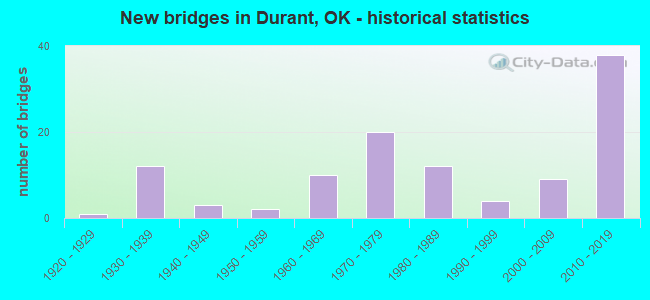
- New bridges - historical statistics
- 11920-1929
- 121930-1939
- 31940-1949
- 21950-1959
- 101960-1969
- 201970-1979
- 121980-1989
- 41990-1999
- 92000-2009
- 382010-2019
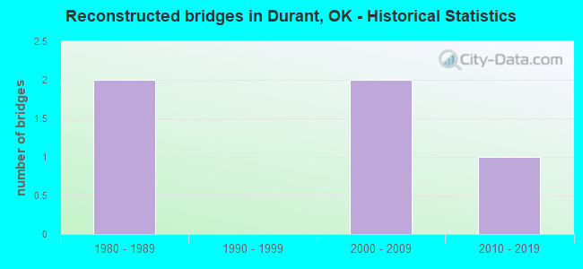
- Reconstructed bridges - Historical Statistics
- 21980-1989
- 01990-1999
- 22000-2009
- 12010-2019
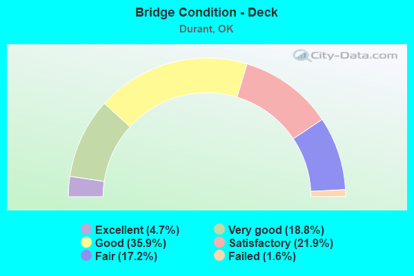
- Bridge Condition - Deck
- 4.7%Excellent
- 18.8%Very good
- 35.9%Good
- 21.9%Satisfactory
- 17.2%Fair
- 1.6%Failed
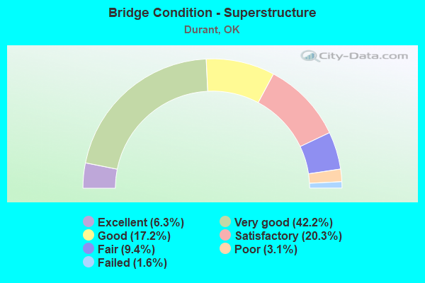
- Bridge Condition - Superstructure
- 6.3%Excellent
- 42.2%Very good
- 17.2%Good
- 20.3%Satisfactory
- 9.4%Fair
- 3.1%Poor
- 1.6%Failed
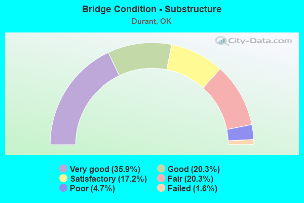
- Bridge Condition - Substructure
- 35.9%Very good
- 20.3%Good
- 17.2%Satisfactory
- 20.3%Fair
- 4.7%Poor
- 1.6%Failed
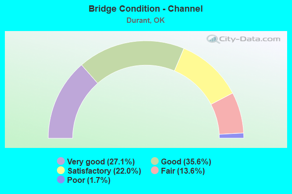
- Bridge Condition - Channel
- 27.1%Very good
- 35.6%Good
- 22.0%Satisfactory
- 13.6%Fair
- 1.7%Poor
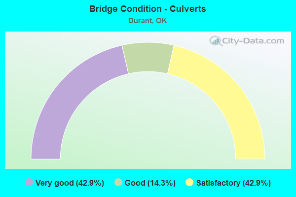
- Bridge Condition - Culverts
- 42.9%Very good
- 14.3%Good
- 42.9%Satisfactory
Find on map >> Show street view
Structure Number: 29819, Location: 2 S OF U.S. 70 (Lat: 33.965053, Lng: -96.373000), Route carried "on" structure: State highway 78, Year Built: 2015, Status: Open, Structure Length: 8.23m (27.00ft), Average Daily Traffic: 4,600 (year 2020), Truck Traffic: 25%, Average Future Daily Traffic: 6,400 (year 2040), Design Load: HL 93, Features Intersected: U.S. 70 BYPASS UNDER
Minimum Vertical Clearance: 30+ m (98+ ft), Kilometerpoint: 65.434, Lanes on structure: 5, Lanes under structure: 5, Owner: State Highway Agency, Approaching Roadway Width: 24.4m (80.1ft), Material/Design: Prestressed concrete, Design/Construction: Stringer/Multi-beam, Number Of Spans In Main Unit: 2, Length of Maximum Span: 41.1m (134.8ft), Curb-To-Curb Width: 25.0m (82.0ft), Out-to-Out Width: 25.0m (82.0ft)
Condition: Deck: Satisfactory, Superstructure: Very good, Substructure: Very good, Operating Rating: 72.6 metric tons, Method Used To Determine Operating Rating: Load and Resistance Factor (LRFR), Inventory Rating: 33.6 metric tons, Method Used To Determine Inventory Rating: Load and Resistance Factor (LRFR), Structural Evaluation: Equal to present desirable criteria, Deck Geometry: Superior to present desirable criteria, Underclear: Equal to present minimum criteria, Approach Roadway Alignment: Equal to present desirable criteria, Designated Inspection Frequency: Every 24 months, Inspection Date: April 2020, Deck Structure Type: Concrete Cast-file-Place, Wearing Surface/Protective System: Wearing Surface: Monolithic Concrete
Find on map >> Show street view
Structure Number: 2982, Location: .77 E OF S.H. 78 (Lat: 33.965169, Lng: -96.359800), Route carried "on" structure: Bypass US 70, Year Built: 2015, Status: Open, Structure Length: 0.91m (2.99ft), Average Daily Traffic: 4,600 (year 2020), Truck Traffic: 25%, Average Future Daily Traffic: 6,400 (year 2040), Design Load: HL 93, Features Intersected: UNNAMED CREEK
Minimum Vertical Clearance: 30+ m (98+ ft), Kilometerpoint: 1.994, Lanes on structure: 2, Base Highway Network: Yes, Owner: State Highway Agency, Approaching Roadway Width: 13.1m (43.0ft), Skew: 3 degrees, Material/Design: Concrete, Design/Construction: Culvert, Number Of Spans In Main Unit: 3, Length of Maximum Span: 3.0m (9.8ft)
Condition: Channel: Very good, Culverts: Very good, Operating Rating: 90.7 metric tons, Method Used To Determine Operating Rating: Load and Resistance Factor (LRFR), Inventory Rating: 90.7 metric tons, Method Used To Determine Inventory Rating: Load and Resistance Factor (LRFR), Structural Evaluation: Equal to present desirable criteria, Waterway Adequacy: Equal to present desirable criteria, Approach Roadway Alignment: Equal to present desirable criteria, Designated Inspection Frequency: Every 24 months, Inspection Date: April 2020
Find on map >> Show street view
Structure Number: 29823, Location: 2.1 E jct 78 (Lat: 33.975347, Lng: -96.339908), Route carried "on" structure: Bypass US 70, Year Built: 2015, Status: Open, Structure Length: 8.81m (28.90ft), Average Daily Traffic: 4,600 (year 2020), Truck Traffic: 25%, Average Future Daily Traffic: 6,400 (year 2040), Design Load: HL 93, Features Intersected: ST.L.SF. R.R. UNDER
Minimum Vertical Clearance: 30+ m (98+ ft), Kilometerpoint: 5.852, Lanes on structure: 2, Base Highway Network: Yes, Owner: State Highway Agency, Approaching Roadway Width: 13.1m (43.0ft), Skew: 1 degrees, Material/Design: Steel, Design/Construction: Stringer/Multi-beam, Number Of Spans In Main Unit: 3, Length of Maximum Span: 34.1m (111.9ft), Curb-To-Curb Width: 13.1m (43.0ft), Out-to-Out Width: 13.4m (44.0ft)
Condition: Deck: Satisfactory, Superstructure: Very good, Substructure: Very good, Operating Rating: 39.9 metric tons, Method Used To Determine Operating Rating: Load and Resistance Factor (LRFR), Inventory Rating: 30.8 metric tons, Method Used To Determine Inventory Rating: Load and Resistance Factor (LRFR), Structural Evaluation: Better than present minimum criteria, Deck Geometry: Equal to present minimum criteria, Approach Roadway Alignment: Equal to present desirable criteria, Designated Inspection Frequency: Every 24 months, Inspection Date: April 2020, Deck Structure Type: Concrete Cast-file-Place, Wearing Surface/Protective System: Wearing Surface: Monolithic Concrete
Find on map >> Show street view
Structure Number: 30526, Location: .7 N OF S.H. 78 JCT (Lat: 34.089167, Lng: -96.368611), Route carried "on" structure: State highway 48, Year Built: 2014, Status: Open, Structure Length: 10.82m (35.50ft), Average Daily Traffic: 2,300 (year 2020), Truck Traffic: 15%, Average Future Daily Traffic: 3,680 (year 2040), Design Load: HL 93, Features Intersected: BLUE RIVER
Minimum Vertical Clearance: 30+ m (98+ ft), Kilometerpoint: 1.030, Lanes on structure: 2, Owner: State Highway Agency, Approaching Roadway Width: 12.2m (40.0ft), Material/Design: Prestressed concrete, Design/Construction: Stringer/Multi-beam, Number Of Spans In Main Unit: 4, Length of Maximum Span: 30.5m (100.1ft), Curb-To-Curb Width: 12.2m (40.0ft), Out-to-Out Width: 12.8m (42.0ft)
Condition: Deck: Good, Superstructure: Very good, Substructure: Very good, Channel: Very good, Operating Rating: 54.4 metric tons, Method Used To Determine Operating Rating: Load and Resistance Factor (LRFR), Inventory Rating: 36.3 metric tons, Method Used To Determine Inventory Rating: Load and Resistance Factor (LRFR), Structural Evaluation: Equal to present desirable criteria, Deck Geometry: Equal to present minimum criteria, Waterway Adequacy: Equal to present desirable criteria, Approach Roadway Alignment: Equal to present desirable criteria, Designated Inspection Frequency: Every 24 months, Inspection Date: April 2020, Deck Structure Type: Concrete Cast-file-Place, Wearing Surface/Protective System: Wearing Surface: Monolithic Concrete
Find on map >> Show street view
Structure Number: 30527, Location: .8 N OF S.H. 78 JCT (Lat: 34.091142, Lng: -96.367539), Route carried "on" structure: State highway 48, Year Built: 2014, Status: Open, Structure Length: 5.49m (18.01ft), Average Daily Traffic: 2,300 (year 2020), Truck Traffic: 15%, Average Future Daily Traffic: 3,680 (year 2040), Design Load: HL 93, Features Intersected: BLUE RIVER O'FLOW
Minimum Vertical Clearance: 30+ m (98+ ft), Kilometerpoint: 1.271, Lanes on structure: 2, Owner: State Highway Agency, Approaching Roadway Width: 12.2m (40.0ft), Material/Design: Prestressed concrete, Design/Construction: Stringer/Multi-beam, Number Of Spans In Main Unit: 4, Length of Maximum Span: 13.7m (44.9ft), Curb-To-Curb Width: 12.2m (40.0ft), Out-to-Out Width: 12.8m (42.0ft)
Condition: Deck: Good, Superstructure: Very good, Substructure: Good, Channel: Very good, Operating Rating: 57.6 metric tons, Method Used To Determine Operating Rating: Load and Resistance Factor (LRFR), Inventory Rating: 44.4 metric tons, Method Used To Determine Inventory Rating: Load and Resistance Factor (LRFR), Structural Evaluation: Better than present minimum criteria, Deck Geometry: Equal to present minimum criteria, Waterway Adequacy: Equal to present desirable criteria, Approach Roadway Alignment: Equal to present desirable criteria, Designated Inspection Frequency: Every 24 months, Inspection Date: April 2020, Deck Structure Type: Concrete Cast-file-Place, Wearing Surface/Protective System: Wearing Surface: Monolithic Concrete
Find on map >> Show street view
Structure Number: 31486, Location: 1S OF COBB (Lat: 34.068386, Lng: -96.407742), Route carried "on" structure: County highway 730C, Year Built: 2018, Status: Open, Structure Length: 3.29m (10.79ft), Average Daily Traffic: 100 (year 2020), Truck Traffic: 15%, Average Future Daily Traffic: 160 (year 2040), Design Load: HS 20+Mod, Features Intersected: LITTLE BLUE CREEK
Minimum Vertical Clearance: 30+ m (98+ ft), Kilometerpoint: 0.161, Lanes on structure: 2, Owner: County Highway Agency, Approaching Roadway Width: 5.5m (18.0ft), Material/Design: Prestressed concrete, Design/Construction: Stringer/Multi-beam, Number Of Spans In Main Unit: 1, Length of Maximum Span: 32.3m (106.0ft), Curb-To-Curb Width: 9.8m (32.2ft), Out-to-Out Width: 10.5m (34.4ft)
Condition: Deck: Very good, Superstructure: Very good, Substructure: Very good, Channel: Good, Operating Rating: 90.6 metric tons, Method Used To Determine Operating Rating: Load Factor (LF), Inventory Rating: 38.1 metric tons, Method Used To Determine Inventory Rating: Load Factor (LF), Structural Evaluation: Equal to present desirable criteria, Deck Geometry: Equal to present desirable criteria, Waterway Adequacy: Equal to present desirable criteria, Approach Roadway Alignment: Better than present minimum criteria, Designated Inspection Frequency: Every 24 months, Inspection Date: June 2020, Deck Structure Type: Concrete Cast-file-Place, Wearing Surface/Protective System: Wearing Surface: Monolithic Concrete
Find on map >> Show street view
Structure Number: 31854, Location: .04N OF WILSON ST. (Lat: 34.012794, Lng: -96.412011), Route carried "on" structure: City street N3708, Year Built: 2008, Status: Open, Structure Length: 1.73m (5.68ft), Average Daily Traffic: 100 (year 2020), Truck Traffic: 5%, Average Future Daily Traffic: 160 (year 2040), Design Load: HS 20, Features Intersected: CREEK
Minimum Vertical Clearance: 30+ m (98+ ft), Kilometerpoint: 1.448, Lanes on structure: 2, Owner: City or Municipal Highway Agency, Approaching Roadway Width: 9.2m (30.2ft), Material/Design: Steel, Design/Construction: Culvert, Number Of Spans In Main Unit: 3, Length of Maximum Span: 4.9m (16.1ft), Curb or Sidewalk Widths: Left: 4.9m (16.1ft), Right: 4.9m (16.1ft), Curb-To-Curb Width: 9.2m (30.2ft), Out-to-Out Width: 19.0m (62.3ft)
Condition: Channel: Satisfactory, Culverts: Satisfactory, Operating Rating: 54.4 metric tons, Method Used To Determine Operating Rating: Load Factor (LF), Inventory Rating: 32.7 metric tons, Method Used To Determine Inventory Rating: Load Factor (LF), Structural Evaluation: Equal to present minimum criteria, Deck Geometry: Better than present minimum criteria, Waterway Adequacy: Better than present minimum criteria, Approach Roadway Alignment: Equal to present desirable criteria, Designated Inspection Frequency: Every 24 months, Inspection Date: August 2020, Total Project Cost: $225,000
Find on map >> Show street view
Structure Number: 17506, Location: JCT US-70 & US-69 (Lat: 33.997714, Lng: -96.404736), Route carried "under" structure: US 70, Year Built: 1969, Structure Length: 0. m, Average Daily Traffic: 16,300 (year 2020), Truck Traffic: 7%, Features Intersected: U.S. 70 UNDER, Facility Carried by Structure: U.S. 69 SB
Minimum Vertical Clearance: 4.98m (16.34ft), Kilometerpoint: 21.255, Lanes on structure: 3, Lanes under structure: 4, Material/Design: Steel continuous, Design/Construction: Stringer/Multi-beam, Length of Maximum Span: 25.3m (83.0ft)
Find on map >> Show street view
Structure Number: 17507, Location: JCT US-70 & US-69 (Lat: 33.998017, Lng: -96.404075), Route carried "under" structure: US 70, Year Built: 1969, Structure Length: 0. m, Average Daily Traffic: 16,300 (year 2020), Truck Traffic: 7%, Features Intersected: U.S. 70 UNDER, Facility Carried by Structure: U.S. 69 NB
Minimum Vertical Clearance: 5.13m (16.83ft), Kilometerpoint: 21.287, Lanes on structure: 3, Lanes under structure: 4, Material/Design: Steel continuous, Design/Construction: Stringer/Multi-beam, Length of Maximum Span: 25.3m (83.0ft)
Find on map >> Show street view
Structure Number: 17523, Location: 2.74 N JCT US-69 BUS (Lat: 33.983056, Lng: -96.414444), Route carried "under" structure: US 69, Year Built: 1969, Structure Length: 0. m, Average Daily Traffic: 23,500 (year 2020), Truck Traffic: 29%, Features Intersected: U.S. 69 UNDER, Facility Carried by Structure: SUNNYSIDE DR
Minimum Vertical Clearance: 4.95m (16.24ft), Kilometerpoint: 4.410, Lanes on structure: 2, Lanes under structure: 4, Material/Design: Steel continuous, Design/Construction: Stringer/Multi-beam, Length of Maximum Span: 27.4m (89.9ft)
Find on map >> Show street view
Structure Number: 17534, Location: 3.77 N JCT US-69 BUS (Lat: 33.996372, Lng: -96.405589), Route carried "under" structure: City street , Year Built: 1969, Structure Length: 0. m, Average Daily Traffic: 4,500 (year 2020), Truck Traffic: 5%, Features Intersected: W ARKANSAS ST & K R.R., Facility Carried by Structure: U.S. 69 SB
Minimum Vertical Clearance: 6.30m (20.67ft), Kilometerpoint: 1.078, Lanes on structure: 2, Lanes under structure: 2, Material/Design: Steel continuous, Design/Construction: Stringer/Multi-beam, Length of Maximum Span: 16.2m (53.1ft)
Find on map >> Show street view
Structure Number: 17535, Location: 3.77 N JCT US-69 BUS (Lat: 33.996758, Lng: -96.404933), Route carried "under" structure: City street , Year Built: 1969, Structure Length: 0. m, Average Daily Traffic: 4,500 (year 2020), Truck Traffic: 5%, Features Intersected: W ARKANSAS ST & K R.R., Facility Carried by Structure: U.S. 69 NB
Minimum Vertical Clearance: 6.61m (21.69ft), Kilometerpoint: 1.094, Lanes on structure: 2, Lanes under structure: 2, Material/Design: Steel continuous, Design/Construction: Stringer/Multi-beam, Length of Maximum Span: 16.2m (53.1ft)
Find on map >> Show street view
Structure Number: 1808, Location: 5.63 N JCT US-69 BUS (Lat: 34.019725, Lng: -96.389794), Route carried "under" structure: City street , Year Built: 1971, Structure Length: 0. m, Average Daily Traffic: 200 (year 2020), Truck Traffic: 5%, Features Intersected: WASHINGTON AVE. UNDER, Facility Carried by Structure: U.S. 69 NB
Minimum Vertical Clearance: 5.18m (16.99ft), Kilometerpoint: 9.059, Lanes on structure: 3, Lanes under structure: 2, Material/Design: Steel continuous, Design/Construction: Stringer/Multi-beam, Length of Maximum Span: 23.8m (78.1ft)
Find on map >> Show street view
Structure Number: 18081, Location: 5.63 N JCT US-69 BUS (Lat: 34.020167, Lng: -96.389947), Route carried "under" structure: City street , Year Built: 1971, Structure Length: 0. m, Average Daily Traffic: 200 (year 2020), Truck Traffic: 5%, Features Intersected: WASHINGTON AVE. UNDER, Facility Carried by Structure: U.S. 69 SB
Minimum Vertical Clearance: 4.47m (14.67ft), Kilometerpoint: 9.059, Lanes on structure: 2, Lanes under structure: 2, Material/Design: Steel continuous, Design/Construction: Stringer/Multi-beam, Length of Maximum Span: 23.8m (78.1ft)
Find on map >> Show street view
Structure Number: 18093, Location: 4.45 N JCT US-69 BUS (Lat: 34.004722, Lng: -96.400000), Route carried "under" structure: US 69, Year Built: 1971, Structure Length: 0. m, Average Daily Traffic: 20,100 (year 2020), Truck Traffic: 29%, Features Intersected: U.S. 69 UNDER, Facility Carried by Structure: UNIVERSITY AVE
Minimum Vertical Clearance: 4.91m (16.11ft), Kilometerpoint: 7.160, Lanes on structure: 3, Lanes under structure: 4, Material/Design: Steel continuous, Design/Construction: Stringer/Multi-beam, Length of Maximum Span: 31.7m (104.0ft)
Find on map >> Show street view
Structure Number: 18554, Location: 7.13 N JCT US-69 BUS (Lat: 34.037569, Lng: -96.375281), Route carried "under" structure: State highway 78, Year Built: 1973, Structure Length: 0. m, Average Daily Traffic: 4,000 (year 2020), Truck Traffic: 16%, Features Intersected: S.H. 78 UNDER, Facility Carried by Structure: U.S. 69 SB
Minimum Vertical Clearance: 5.64m (18.50ft), Kilometerpoint: 4.537, Lanes on structure: 3, Lanes under structure: 4, Material/Design: Prestressed concrete, Design/Construction: Stringer/Multi-beam, Length of Maximum Span: 29.3m (96.1ft)
Find on map >> Show street view
Structure Number: 18555, Location: 7.13 N JCT US-69 BUS (Lat: 34.037392, Lng: -96.375181), Route carried "under" structure: State highway 78, Year Built: 1973, Structure Length: 0. m, Average Daily Traffic: 4,000 (year 2020), Truck Traffic: 16%, Features Intersected: S.H. 78 UNDER, Facility Carried by Structure: U.S. 69 NB
Minimum Vertical Clearance: 4.95m (16.24ft), Kilometerpoint: 4.571, Lanes on structure: 2, Lanes under structure: 4, Material/Design: Prestressed concrete, Design/Construction: Stringer/Multi-beam, Length of Maximum Span: 29.3m (96.1ft)
Find on map >> Show street view
Structure Number: 18578, Location: 6.77 N JCT US-69 BUS (Lat: 34.033836, Lng: -96.379558), Route carried "under" structure: US 69, Year Built: 1973, Structure Length: 0. m, Average Daily Traffic: 20,500 (year 2020), Truck Traffic: 29%, Features Intersected: U.S. 69 UNDER, Facility Carried by Structure: RED BUD LN
Minimum Vertical Clearance: 4.78m (15.68ft), Kilometerpoint: 10.894, Lanes on structure: 2, Lanes under structure: 4, Material/Design: Steel continuous, Design/Construction: Stringer/Multi-beam, Length of Maximum Span: 36.6m (120.1ft)
Find on map >> Show street view
Structure Number: 20303, Location: 8.53 N JCT US-69 BUS (Lat: 34.051111, Lng: -96.358056), Route carried "under" structure: US 69, Year Built: 1982, Structure Length: 0. m, Average Daily Traffic: 17,900 (year 2020), Truck Traffic: 29%, Features Intersected: U.S. 69 UNDER, Facility Carried by Structure: URY DR
Minimum Vertical Clearance: 5.09m (16.70ft), Kilometerpoint: 13.724, Lanes on structure: 2, Lanes under structure: 4, Material/Design: Prestressed concrete, Design/Construction: Stringer/Multi-beam, Length of Maximum Span: 29.3m (96.1ft)
Find on map >> Show street view
Structure Number: 20318, Location: 12.19 N JCT US-69 BUS (Lat: 34.093611, Lng: -96.320556), Route carried "under" structure: US 69, Year Built: 1982, Structure Length: 0. m, Average Daily Traffic: 18,000 (year 2020), Truck Traffic: 29%, Features Intersected: U.S. 69 UNDER, Facility Carried by Structure: HAT POWELL RD
Minimum Vertical Clearance: 5.00m (16.40ft), Kilometerpoint: 19.615, Lanes on structure: 2, Lanes under structure: 4, Material/Design: Prestressed concrete continuous, Design/Construction: Box Beam or Girders - Multiple, Length of Maximum Span: 45.7m (149.9ft)
Find on map >> Show street view
Structure Number: 20321, Location: 10.65 N JCT US-69 BUS (Lat: 34.076944, Lng: -96.338056), Route carried "under" structure: US 69, Year Built: 1982, Structure Length: 0. m, Average Daily Traffic: 18,000 (year 2020), Truck Traffic: 29%, Features Intersected: U.S. 69 UNDER, Facility Carried by Structure: FISH HATCHERY RD
Minimum Vertical Clearance: 4.91m (16.11ft), Kilometerpoint: 17.136, Lanes on structure: 2, Lanes under structure: 4, Material/Design: Steel continuous, Design/Construction: Stringer/Multi-beam, Length of Maximum Span: 50.3m (165.0ft)
Find on map >> Show street view
Structure Number: 29333, Location: 1.00 S JCT US-70 (Lat: 33.983089, Lng: -96.428106), Route carried "under" structure: US 70, Year Built: 2010, Structure Length: 0. m, Average Daily Traffic: 7,800 (year 2020), Truck Traffic: 25%, Features Intersected: U.S. 70 BYPASS UNDER, Facility Carried by Structure: SUNNYSIDE DR
Minimum Vertical Clearance: 5.36m (17.59ft), Kilometerpoint: 1.609, Lanes on structure: 2, Lanes under structure: 4, Material/Design: Prestressed concrete, Design/Construction: Stringer/Multi-beam, Length of Maximum Span: 27.4m (89.9ft)
Find on map >> Show street view
Structure Number: 29334, Location: 1.50 S JCT US-70 (Lat: 33.976111, Lng: -96.424975), Route carried "under" structure: US 70, Year Built: 2010, Structure Length: 0. m, Average Daily Traffic: 7,800 (year 2020), Truck Traffic: 25%, Features Intersected: U.S. 70 BYPASS UNDER, Facility Carried by Structure: CALE SWITCH RD
Minimum Vertical Clearance: 5.84m (19.16ft), Kilometerpoint: 2.414, Lanes on structure: 2, Lanes under structure: 4, Material/Design: Steel, Design/Construction: Stringer/Multi-beam, Length of Maximum Span: 36.3m (119.1ft)
Find on map >> Show street view
Structure Number: 29336, Location: 2.00 S JCT US-70 (Lat: 33.969633, Lng: -96.417050), Route carried "under" structure: US 69, Year Built: 2010, Structure Length: 0. m, Average Daily Traffic: 3,900 (year 2020), Truck Traffic: 8%, Features Intersected: U.S. 69 / U.S. 75 UNDER, Facility Carried by Structure: U.S. 70 BYPASS
Minimum Vertical Clearance: 5.00m (16.40ft), Kilometerpoint: 2.927, Lanes on structure: 3, Lanes under structure: 4, Material/Design: Steel, Design/Construction: Stringer/Multi-beam, Length of Maximum Span: 34.1m (111.9ft)
Find on map >> Show street view
Structure Number: 29337, Location: 2.00 S JCT US-70 (Lat: 33.969119, Lng: -96.417067), Route carried "under" structure: US 69, Year Built: 2010, Structure Length: 0. m, Average Daily Traffic: 3,900 (year 2020), Truck Traffic: 8%, Features Intersected: U.S. 69 / U.S. 75 UNDER, Facility Carried by Structure: U.S. 70 BYPASS
Minimum Vertical Clearance: 5.36m (17.59ft), Kilometerpoint: 2.927, Lanes on structure: 3, Lanes under structure: 4, Material/Design: Steel, Design/Construction: Stringer/Multi-beam, Length of Maximum Span: 33.8m (110.9ft)
Find on map >> Show street view
Structure Number: 29338, Location: 2.10 S JCT US-70 (Lat: 33.967456, Lng: -96.412456), Route carried "under" structure: County highway 70, Year Built: 2010, Structure Length: 0. m, Average Daily Traffic: 1,000 (year 2020), Truck Traffic: 10%, Features Intersected: ENTERPRISE BLVD UNDER
Minimum Vertical Clearance: 5.12m (16.80ft), Kilometerpoint: 0.000, Lanes on structure: 3, Lanes under structure: 2, Material/Design: Prestressed concrete, Design/Construction: Stringer/Multi-beam, Length of Maximum Span: 24.4m (80.1ft)
Find on map >> Show street view
Structure Number: 29339, Location: 2.10 S JCT US-70 (Lat: 33.967006, Lng: -96.412447), Route carried "under" structure: County highway _, Year Built: 2010, Structure Length: 0. m, Average Daily Traffic: 1,000 (year 2020), Truck Traffic: 10%, Features Intersected: ENTERPRISE BLVD UNDER, Facility Carried by Structure: U.S. 70 BYPASS
Minimum Vertical Clearance: 5.30m (17.39ft), Kilometerpoint: 3.380, Lanes on structure: 2, Lanes under structure: 2, Material/Design: Prestressed concrete, Design/Construction: Stringer/Multi-beam, Length of Maximum Span: 24.4m (80.1ft)
Find on map >> Show street view
Structure Number: 2934, Location: 2.10 S JCT US-70 (Lat: 33.966753, Lng: -96.412433), Route carried "under" structure: Ramp County highway 70, Year Built: 2010, Structure Length: 0. m, Average Daily Traffic: 1,000 (year 2020), Features Intersected: ENTERPRISE BLVD UNDER
Minimum Vertical Clearance: 5.12m (16.80ft), Kilometerpoint: 0.000, Lanes on structure: 1, Lanes under structure: 2, Material/Design: Prestressed concrete, Design/Construction: Stringer/Multi-beam, Length of Maximum Span: 22.9m (75.1ft)
Find on map >> Show street view
Structure Number: 29372, Location: 0.5 N JCT US-69 (Lat: 33.946817, Lng: -96.416475), Route carried "under" structure: US 69, Year Built: 2011, Structure Length: 0. m, Average Daily Traffic: 25,000 (year 2020), Truck Traffic: 20%, Features Intersected: U.S. 69 UNDER
Minimum Vertical Clearance: 5.06m (16.60ft), Kilometerpoint: 0.805, Lanes on structure: 1, Lanes under structure: 6, Material/Design: Steel, Design/Construction: Stringer/Multi-beam, Length of Maximum Span: 45.1m (148.0ft)
Find on map >> Show street view
Structure Number: 29456, Location: 1.22 E JCT US-69 (Lat: 33.965250, Lng: -96.396461), Route carried "under" structure: Business US 69, Year Built: 2010, Structure Length: 0. m, Average Daily Traffic: 3,600 (year 2020), Truck Traffic: 15%, Features Intersected: U.S. 69 BUSINESS UNDER, Facility Carried by Structure: U.S. 70 BYPASS
Minimum Vertical Clearance: 6.93m (22.74ft), Kilometerpoint: 5.472, Lanes on structure: 3, Lanes under structure: 2, Material/Design: Prestressed concrete, Design/Construction: Stringer/Multi-beam, Length of Maximum Span: 40.2m (131.9ft)
Find on map >> Show street view
Structure Number: 29457, Location: 1.22 E JCT US-69 (Lat: 33.965678, Lng: -96.396103), Route carried "under" structure: Bypass US 69B, Year Built: 2010, Structure Length: 0. m, Average Daily Traffic: 3,600 (year 2020), Truck Traffic: 15%, Features Intersected: U.S. 69 BUSINESS UNDER, Facility Carried by Structure: U.S. 70 BYPASS
Minimum Vertical Clearance: 7.31m (23.98ft), Kilometerpoint: 5.472, Lanes on structure: 3, Lanes under structure: 2, Material/Design: Prestressed concrete, Design/Construction: Stringer/Multi-beam, Length of Maximum Span: 40.2m (131.9ft)
Find on map >> Show street view
Structure Number: 29818, Location: 2.9 e of jct 78 (Lat: 33.986389, Lng: -96.339444), Route carried "under" structure: City street , Year Built: 2015, Structure Length: 0. m, Average Daily Traffic: 100 (year 2020), Truck Traffic: 10%, Features Intersected: HILLCREST DRIVE UNDER, Facility Carried by Structure: U.S. 70 BYPASS
Minimum Vertical Clearance: 5.36m (17.59ft), Kilometerpoint: 0.000, Lanes on structure: 2, Lanes under structure: 2, Material/Design: Prestressed concrete, Design/Construction: Stringer/Multi-beam, Length of Maximum Span: 30.5m (100.1ft)
Find on map >> Show street view
Structure Number: 29819, Location: 2 S OF U.S. 70 (Lat: 33.965053, Lng: -96.373000), Route carried "under" structure: Bypass US 70, Year Built: 2015, Structure Length: 0. m, Average Daily Traffic: 4,600 (year 2020), Truck Traffic: 25%, Features Intersected: U.S. 70 BYPASS UNDER, Facility Carried by Structure: S.H. 78
Minimum Vertical Clearance: 5.46m (17.91ft), Kilometerpoint: 40.658, Lanes on structure: 5, Lanes under structure: 4, Material/Design: Prestressed concrete, Design/Construction: Stringer/Multi-beam, Length of Maximum Span: 41.1m (134.8ft)