Bridge Statistics for Easley, South Carolina (SC)
Condition, Traffic, Stress, Structural Evaluation, Project Costs

- New bridges - historical statistics
- 11930-1939
- 11940-1949
- 41950-1959
- 181960-1969
- 41970-1979
- 31980-1989
- 31990-1999
- 162000-2009
- 52010-2019
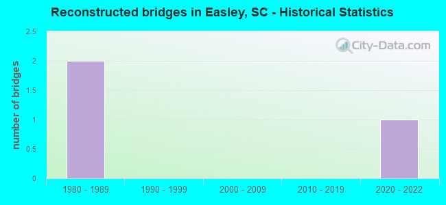
- Reconstructed bridges - Historical Statistics
- 21980-1989
- 01990-1999
- 02000-2009
- 02010-2019
- 12020-2022
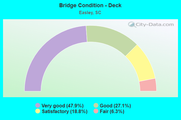
- Bridge Condition - Deck
- 47.9%Very good
- 27.1%Good
- 18.8%Satisfactory
- 6.3%Fair
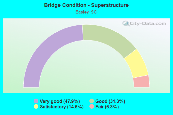
- Bridge Condition - Superstructure
- 47.9%Very good
- 31.3%Good
- 14.6%Satisfactory
- 6.3%Fair
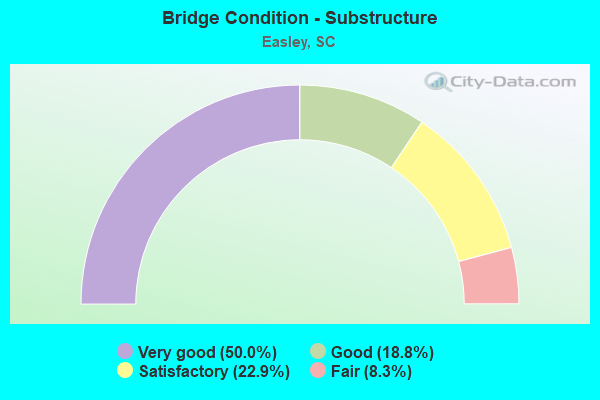
- Bridge Condition - Substructure
- 50.0%Very good
- 18.8%Good
- 22.9%Satisfactory
- 8.3%Fair
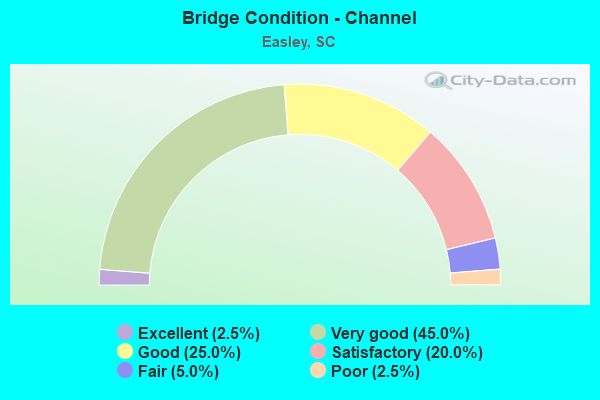
- Bridge Condition - Channel
- 2.5%Excellent
- 45.0%Very good
- 25.0%Good
- 20.0%Satisfactory
- 5.0%Fair
- 2.5%Poor
Find on map >> Show street view
Structure Number: 7927, Location: 4.2 MI E EASLEY (Lat: 34.828283, Lng: -82.528528), Route carried "on" structure: State highway 153, Year Built: 1985, Year Reconstructed: 2020, Status: Open, Structure Length: 9.51m (31.20ft), Average Daily Traffic: 17,600 (year 2020), Truck Traffic: 8%, Average Future Daily Traffic: 22,352 (year 2040), Design Load: HS 20, Features Intersected: US 123
Minimum Vertical Clearance: 30+ m (98+ ft), Kilometerpoint: 2.824, Lanes on structure: 3, Lanes under structure: 5, Owner: State Highway Agency, Approaching Roadway Width: 13.4m (44.0ft), Skew: 2 degrees, Material/Design: Steel continuous, Design/Construction: Stringer/Multi-beam, Number Of Spans In Main Unit: 2, Number Of Approach Spans: 2, Length of Maximum Span: 26.5m (86.9ft), Curb-To-Curb Width: 14.9m (48.9ft), Out-to-Out Width: 18.1m (59.4ft)
Condition: Deck: Very good, Superstructure: Very good, Substructure: Very good, Operating Rating: 37.3 metric tons, Method Used To Determine Operating Rating: Load and Resistance Factor Rating (LRFR) rating reported by rating factor(RF) method using HL-93 loadings, Inventory Rating: 28.5 metric tons, Method Used To Determine Inventory Rating: Load and Resistance Factor Rating (LRFR) rating reported by rating factor(RF) method using HL-93 loadings, Structural Evaluation: Better than present minimum criteria, Deck Geometry: Equal to present minimum criteria, Underclear: Superior to present desirable criteria, Approach Roadway Alignment: Equal to present desirable criteria, Bridge Posting: Required (Relationship of Operating Rating to Maximum Legal Load: > 39.9% below), Length Of Structure Improvement: 10.59m (34.74ft), Designated Inspection Frequency: Every 24 months, Inspection Date: June 2020, Bridge Improvement Cost: $1,340,000, Roadway Improvement Cost: $335,000, Total Project Cost: $2,010,000 ( Estimate for 2021), Deck Structure Type: Concrete Cast-file-Place, Wearing Surface/Protective System: Wearing Surface: Monolithic Concrete
Find on map >> Show street view
Structure Number: 8381, Location: 4.0 MI S EASLEY (Lat: 34.771519, Lng: -82.615889), Route carried "on" structure: State highway 179, Year Built: 1990, Status: Open, Structure Length: 1.83m (6.00ft), Average Daily Traffic: 600 (year 2020), Truck Traffic: 5%, Average Future Daily Traffic: 768 (year 2040), Design Load: HS 20, Features Intersected: TRIB TO 23 MI.CREEK
Minimum Vertical Clearance: 30+ m (98+ ft), Kilometerpoint: 2.615, Lanes on structure: 2, Owner: State Highway Agency, Approaching Roadway Width: 5.2m (17.1ft), Material/Design: Prestressed concrete, Design/Construction: Slab, Number Of Spans In Main Unit: 1, Number Of Approach Spans: 2, Length of Maximum Span: 9.1m (29.9ft), Curb-To-Curb Width: 10.4m (34.1ft), Out-to-Out Width: 11.8m (38.7ft)
Condition: Deck: Very good, Superstructure: Very good, Substructure: Very good, Channel: Very good, Operating Rating: 27.5 metric tons, Method Used To Determine Operating Rating: Load and Resistance Factor Rating (LRFR) rating reported by rating factor(RF) method using HL-93 loadings, Inventory Rating: 19.1 metric tons, Method Used To Determine Inventory Rating: Load and Resistance Factor Rating (LRFR) rating reported by rating factor(RF) method using HL-93 loadings, Structural Evaluation: Somewhat better than minimum adequacy, Deck Geometry: Equal to present minimum criteria, Waterway Adequacy: Equal to present desirable criteria, Approach Roadway Alignment: Better than present minimum criteria, Length Of Structure Improvement: 1.83m (6.00ft), Designated Inspection Frequency: Every 24 months, Inspection Date: November 2020, Deck Structure Type: Concrete Precast Panels, Wearing Surface/Protective System: Wearing Surface: Monolithic Concrete
Find on map >> Show street view
Structure Number: 8585, Location: 5.0 MI E EASLEY (Lat: 34.854461, Lng: -82.519867), Route carried "on" structure: State highway 36, Year Built: 1992, Status: Open, Structure Length: 3.66m (12.01ft), Average Daily Traffic: 5,100 (year 2020), Truck Traffic: 2%, Average Future Daily Traffic: 7,803 (year 2040), Design Load: HS 20, Features Intersected: GEORGES CREEK
Minimum Vertical Clearance: 30+ m (98+ ft), Kilometerpoint: 6.565, Lanes on structure: 2, Owner: State Highway Agency, Approaching Roadway Width: 7.3m (24.0ft), Material/Design: Prestressed concrete, Design/Construction: Slab, Number Of Spans In Main Unit: 3, Length of Maximum Span: 12.2m (40.0ft), Curb-To-Curb Width: 10.4m (34.1ft), Out-to-Out Width: 11.8m (38.7ft)
Condition: Deck: Good, Superstructure: Good, Substructure: Fair, Channel: Very good, Operating Rating: 20.4 metric tons, Method Used To Determine Operating Rating: Load and Resistance Factor Rating (LRFR) rating reported by rating factor(RF) method using HL-93 loadings, Inventory Rating: 12.0 metric tons, Method Used To Determine Inventory Rating: Load and Resistance Factor Rating (LRFR) rating reported by rating factor(RF) method using HL-93 loadings, Structural Evaluation: High priority of corrective action, Deck Geometry: Meets minimum limits, Waterway Adequacy: Better than present minimum criteria, Approach Roadway Alignment: Equal to present desirable criteria, Length Of Structure Improvement: 4.54m (14.90ft), Designated Inspection Frequency: Every 24 months, Inspection Date: October 2020, Bridge Improvement Cost: $166,000, Roadway Improvement Cost: $42,000, Total Project Cost: $249,000 ( Estimate for 2021), Deck Structure Type: Concrete Precast Panels, Wearing Surface/Protective System: Wearing Surface: Bituminous
Find on map >> Show street view
Structure Number: 9068, Location: 5.0 MI E EASLEY (Lat: 34.823911, Lng: -82.515853), Route carried "on" structure: State highway 144, Year Built: 1996, Status: Open, Structure Length: 2.99m (9.81ft), Average Daily Traffic: 1,550 (year 2020), Truck Traffic: 5%, Average Future Daily Traffic: 1,984 (year 2040), Design Load: HS 25 or greater, Features Intersected: TRIB TO SALUDA RIVER
Minimum Vertical Clearance: 30+ m (98+ ft), Kilometerpoint: 2.129, Lanes on structure: 2, Owner: State Highway Agency, Approaching Roadway Width: 6.3m (20.7ft), Material/Design: Concrete continuous, Design/Construction: Slab, Number Of Spans In Main Unit: 3, Length of Maximum Span: 10.1m (33.1ft), Curb-To-Curb Width: 10.2m (33.5ft), Out-to-Out Width: 11.6m (38.1ft)
Condition: Deck: Very good, Superstructure: Very good, Substructure: Very good, Channel: Good, Operating Rating: 51.8 metric tons, Method Used To Determine Operating Rating: Load and Resistance Factor Rating (LRFR) rating reported by rating factor(RF) method using HL-93 loadings, Inventory Rating: 40.2 metric tons, Method Used To Determine Inventory Rating: Load and Resistance Factor Rating (LRFR) rating reported by rating factor(RF) method using HL-93 loadings, Structural Evaluation: Equal to present desirable criteria, Deck Geometry: Somewhat better than minimum adequacy, Waterway Adequacy: Equal to present desirable criteria, Approach Roadway Alignment: Equal to present desirable criteria, Length Of Structure Improvement: 2.99m (9.81ft), Designated Inspection Frequency: Every 24 months, Inspection Date: October 2020, Deck Structure Type: Concrete Cast-file-Place, Wearing Surface/Protective System: Wearing Surface: Monolithic Concrete
Find on map >> Show street view
Structure Number: 9582, Location: 4.0MI NE OF EASLEY (Lat: 34.859519, Lng: -82.541200), Route carried "on" structure: County highway 459, Year Built: 2001, Status: Open, Structure Length: 1.52m (4.99ft), Average Daily Traffic: 375 (year 2020), Truck Traffic: 4%, Average Future Daily Traffic: 574 (year 2040), Design Load: HS 20, Features Intersected: GEORGES CREEK
Minimum Vertical Clearance: 30+ m (98+ ft), Kilometerpoint: 1.130, Lanes on structure: 2, Owner: County Highway Agency, Approaching Roadway Width: 7.6m (24.9ft), Material/Design: Prestressed concrete, Design/Construction: Slab, Number Of Spans In Main Unit: 1, Length of Maximum Span: 15.2m (49.9ft), Curb-To-Curb Width: 7.4m (24.3ft), Out-to-Out Width: 8.3m (27.2ft)
Condition: Deck: Very good, Superstructure: Very good, Substructure: Very good, Channel: Satisfactory, Operating Rating: 45.4 metric tons, Method Used To Determine Operating Rating: Load and Resistance Factor Rating (LRFR) rating reported by rating factor(RF) method using HL-93 loadings, Inventory Rating: 28.8 metric tons, Method Used To Determine Inventory Rating: Load and Resistance Factor Rating (LRFR) rating reported by rating factor(RF) method using HL-93 loadings, Structural Evaluation: Better than present minimum criteria, Deck Geometry: Somewhat better than minimum adequacy, Waterway Adequacy: Better than present minimum criteria, Approach Roadway Alignment: Better than present minimum criteria, Length Of Structure Improvement: 1.52m (4.99ft), Designated Inspection Frequency: Every 24 months, Inspection Date: April 2020, Deck Structure Type: Concrete Precast Panels, Wearing Surface/Protective System: Wearing Surface: Bituminous
Find on map >> Show street view
Structure Number: 9644, Location: 2.0 MI NE OF EASLEY (Lat: 34.884125, Lng: -82.548956), Route carried "on" structure: County highway 863, Year Built: 2001, Status: Open, Structure Length: 0.91m (2.99ft), Average Daily Traffic: 200 (year 2020), Truck Traffic: 5%, Average Future Daily Traffic: 256 (year 2040), Design Load: HS 20, Features Intersected: TRIB TO BURDINE CREEK
Minimum Vertical Clearance: 30+ m (98+ ft), Kilometerpoint: 0.303, Lanes on structure: 2, Owner: County Highway Agency, Approaching Roadway Width: 6.7m (22.0ft), Material/Design: Prestressed concrete, Design/Construction: Slab, Number Of Spans In Main Unit: 1, Length of Maximum Span: 9.1m (29.9ft), Curb-To-Curb Width: 7.1m (23.3ft), Out-to-Out Width: 8.5m (27.9ft)
Condition: Deck: Very good, Superstructure: Very good, Substructure: Very good, Channel: Very good, Operating Rating: 26.6 metric tons, Method Used To Determine Operating Rating: Load and Resistance Factor Rating (LRFR) rating reported by rating factor(RF) method using HL-93 loadings, Inventory Rating: 18.1 metric tons, Method Used To Determine Inventory Rating: Load and Resistance Factor Rating (LRFR) rating reported by rating factor(RF) method using HL-93 loadings, Structural Evaluation: Somewhat better than minimum adequacy, Deck Geometry: Meets minimum limits, Waterway Adequacy: Equal to present desirable criteria, Approach Roadway Alignment: Equal to present desirable criteria, Length Of Structure Improvement: 0.91m (2.99ft), Designated Inspection Frequency: Every 24 months, Inspection Date: April 2020, Deck Structure Type: Concrete Precast Panels, Wearing Surface/Protective System: Wearing Surface: Monolithic Concrete
Find on map >> Show street view
Structure Number: 10237, Location: 2.8 MI SW OF EASLEY (Lat: 34.807361, Lng: -82.642697), Route carried "on" structure: County highway 1905, Year Built: 2008, Status: Open, Structure Length: 0.91m (2.99ft), Average Daily Traffic: 200 (year 2020), Truck Traffic: 4%, Average Future Daily Traffic: 256 (year 2040), Design Load: HS 20, Features Intersected: TRIB EIGHTEEN MILE CREEK
Minimum Vertical Clearance: 30+ m (98+ ft), Kilometerpoint: 0.504, Lanes on structure: 2, Owner: County Highway Agency, Approaching Roadway Width: 7.6m (24.9ft), Material/Design: Prestressed concrete, Design/Construction: Slab, Number Of Spans In Main Unit: 1, Length of Maximum Span: 9.1m (29.9ft), Curb-To-Curb Width: 7.5m (24.6ft), Out-to-Out Width: 8.4m (27.6ft)
Condition: Deck: Very good, Superstructure: Very good, Substructure: Very good, Channel: Very good, Operating Rating: 26.9 metric tons, Method Used To Determine Operating Rating: Load and Resistance Factor Rating (LRFR) rating reported by rating factor(RF) method using HL-93 loadings, Inventory Rating: 18.1 metric tons, Method Used To Determine Inventory Rating: Load and Resistance Factor Rating (LRFR) rating reported by rating factor(RF) method using HL-93 loadings, Structural Evaluation: Somewhat better than minimum adequacy, Deck Geometry: Somewhat better than minimum adequacy, Waterway Adequacy: Equal to present desirable criteria, Approach Roadway Alignment: Equal to present desirable criteria, Length Of Structure Improvement: 0.91m (2.99ft), Designated Inspection Frequency: Every 24 months, Inspection Date: April 2020, Deck Structure Type: Concrete Precast Panels, Wearing Surface/Protective System: Wearing Surface: Bituminous
Find on map >> Show street view
Structure Number: 1024, Location: 2.6 MI NE OF LIBERTY (Lat: 34.800675, Lng: -82.648653), Route carried "on" structure: County highway 486, Year Built: 2009, Status: Open, Structure Length: 0.91m (2.99ft), Average Daily Traffic: 200 (year 2020), Truck Traffic: 4%, Average Future Daily Traffic: 256 (year 2040), Design Load: HS 20, Features Intersected: TRIB EIGHTEEN MILE CREEK
Minimum Vertical Clearance: 30+ m (98+ ft), Kilometerpoint: 0.486, Lanes on structure: 2, Owner: County Highway Agency, Approaching Roadway Width: 6.5m (21.3ft), Material/Design: Prestressed concrete, Design/Construction: Slab, Number Of Spans In Main Unit: 1, Length of Maximum Span: 9.1m (29.9ft), Curb-To-Curb Width: 7.5m (24.6ft), Out-to-Out Width: 8.4m (27.6ft)
Condition: Deck: Very good, Superstructure: Very good, Substructure: Very good, Channel: Very good, Operating Rating: 27.2 metric tons, Method Used To Determine Operating Rating: Load and Resistance Factor Rating (LRFR) rating reported by rating factor(RF) method using HL-93 loadings, Inventory Rating: 18.5 metric tons, Method Used To Determine Inventory Rating: Load and Resistance Factor Rating (LRFR) rating reported by rating factor(RF) method using HL-93 loadings, Structural Evaluation: Somewhat better than minimum adequacy, Deck Geometry: Somewhat better than minimum adequacy, Waterway Adequacy: Equal to present desirable criteria, Approach Roadway Alignment: Equal to present desirable criteria, Length Of Structure Improvement: 0.91m (2.99ft), Designated Inspection Frequency: Every 24 months, Inspection Date: April 2020, Deck Structure Type: Concrete Precast Panels, Wearing Surface/Protective System: Wearing Surface: Bituminous
Find on map >> Show street view
Structure Number: 10242, Location: 2.8 MI SW OF EASLEY (Lat: 34.808633, Lng: -82.643597), Route carried "on" structure: County highway 1598, Year Built: 2008, Status: Open, Structure Length: 0.91m (2.99ft), Average Daily Traffic: 200 (year 2020), Truck Traffic: 4%, Average Future Daily Traffic: 256 (year 2040), Design Load: HS 20, Features Intersected: TRIB EIGHTEEN MILE CREEK
Minimum Vertical Clearance: 30+ m (98+ ft), Kilometerpoint: 0.016, Lanes on structure: 2, Owner: County Highway Agency, Approaching Roadway Width: 7.9m (25.9ft), Material/Design: Prestressed concrete, Design/Construction: Slab, Number Of Spans In Main Unit: 1, Length of Maximum Span: 9.1m (29.9ft), Curb-To-Curb Width: 7.5m (24.6ft), Out-to-Out Width: 8.4m (27.6ft)
Condition: Deck: Very good, Superstructure: Very good, Substructure: Very good, Channel: Very good, Operating Rating: 26.9 metric tons, Method Used To Determine Operating Rating: Load and Resistance Factor Rating (LRFR) rating reported by rating factor(RF) method using HL-93 loadings, Inventory Rating: 18.1 metric tons, Method Used To Determine Inventory Rating: Load and Resistance Factor Rating (LRFR) rating reported by rating factor(RF) method using HL-93 loadings, Structural Evaluation: Somewhat better than minimum adequacy, Deck Geometry: Somewhat better than minimum adequacy, Waterway Adequacy: Equal to present desirable criteria, Approach Roadway Alignment: Equal to present desirable criteria, Length Of Structure Improvement: 0.91m (2.99ft), Designated Inspection Frequency: Every 24 months, Inspection Date: April 2020, Deck Structure Type: Concrete Precast Panels, Wearing Surface/Protective System: Wearing Surface: Bituminous
Find on map >> Show street view
Structure Number: 10247, Location: 2.8 MI SW OF EASLEY (Lat: 34.806928, Lng: -82.641753), Route carried "on" structure: County highway 1548, Year Built: 2008, Status: Open, Structure Length: 1.22m (4.00ft), Average Daily Traffic: 200 (year 2020), Truck Traffic: 5%, Average Future Daily Traffic: 256 (year 2040), Design Load: HS 20, Features Intersected: TRIB EIGHTEENMILE CREEK
Minimum Vertical Clearance: 30+ m (98+ ft), Kilometerpoint: 0.364, Lanes on structure: 2, Owner: County Highway Agency, Approaching Roadway Width: 6.9m (22.6ft), Material/Design: Prestressed concrete, Design/Construction: Slab, Number Of Spans In Main Unit: 1, Length of Maximum Span: 12.2m (40.0ft), Curb-To-Curb Width: 7.5m (24.6ft), Out-to-Out Width: 8.4m (27.6ft)
Condition: Deck: Very good, Superstructure: Very good, Substructure: Very good, Channel: Very good, Operating Rating: 18.1 metric tons, Method Used To Determine Operating Rating: Load and Resistance Factor Rating (LRFR) rating reported by rating factor(RF) method using HL-93 loadings, Inventory Rating: 10.7 metric tons, Method Used To Determine Inventory Rating: Load and Resistance Factor Rating (LRFR) rating reported by rating factor(RF) method using HL-93 loadings, Structural Evaluation: High priority of corrective action, Deck Geometry: Somewhat better than minimum adequacy, Waterway Adequacy: Equal to present desirable criteria, Approach Roadway Alignment: Equal to present desirable criteria, Length Of Structure Improvement: 1.89m (6.20ft), Designated Inspection Frequency: Every 24 months, Inspection Date: April 2020, Bridge Improvement Cost: $67,000, Roadway Improvement Cost: $17,000, Total Project Cost: $101,000 ( Estimate for 2021), Deck Structure Type: Concrete Precast Panels, Wearing Surface/Protective System: Wearing Surface: Bituminous
Find on map >> Show street view
Structure Number: 10248, Location: 4.9 MI SW OF EASLEY (Lat: 34.759981, Lng: -82.623083), Route carried "on" structure: County highway 179, Year Built: 2007, Status: Open, Structure Length: 0.91m (2.99ft), Average Daily Traffic: 200 (year 2020), Truck Traffic: 5%, Average Future Daily Traffic: 256 (year 2040), Design Load: HS 20, Features Intersected: UNKNOWN CREEK
Minimum Vertical Clearance: 30+ m (98+ ft), Kilometerpoint: 1.032, Lanes on structure: 2, Owner: County Highway Agency, Approaching Roadway Width: 6.2m (20.3ft), Material/Design: Prestressed concrete, Design/Construction: Slab, Number Of Spans In Main Unit: 1, Length of Maximum Span: 9.1m (29.9ft), Curb-To-Curb Width: 7.0m (23.0ft), Out-to-Out Width: 8.4m (27.6ft)
Condition: Deck: Very good, Superstructure: Very good, Substructure: Very good, Channel: Very good, Operating Rating: 28.2 metric tons, Method Used To Determine Operating Rating: Load and Resistance Factor Rating (LRFR) rating reported by rating factor(RF) method using HL-93 loadings, Inventory Rating: 19.8 metric tons, Method Used To Determine Inventory Rating: Load and Resistance Factor Rating (LRFR) rating reported by rating factor(RF) method using HL-93 loadings, Structural Evaluation: Somewhat better than minimum adequacy, Deck Geometry: Meets minimum limits, Waterway Adequacy: Equal to present desirable criteria, Approach Roadway Alignment: Somewhat better than minimum adequacy, Length Of Structure Improvement: 0.91m (2.99ft), Designated Inspection Frequency: Every 24 months, Inspection Date: April 2020, Deck Structure Type: Concrete Precast Panels, Wearing Surface/Protective System: Wearing Surface: Bituminous
Find on map >> Show street view
Structure Number: 3969, Location: 2.0MI SW OF EASLEY (Lat: 34.804433, Lng: -82.621750), Route carried "under" structure: US 123, Year Built: 1962, Structure Length: 0. m, Average Daily Traffic: 26,400 (year 2020), Truck Traffic: 5%, Features Intersected: US 123, Facility Carried by Structure: S-39-186
Minimum Vertical Clearance: 5.11m (16.77ft), Kilometerpoint: 26.425, Lanes on structure: 2, Lanes under structure: 4, Material/Design: Prestressed concrete, Design/Construction: Stringer/Multi-beam, Length of Maximum Span: 16.8m (55.1ft)
Find on map >> Show street view
Structure Number: 4193, Location: CITY OF EASLEY (Lat: 34.818172, Lng: -82.601378), Route carried "under" structure: State highway 135, Year Built: 1963, Structure Length: 0. m, Average Daily Traffic: 12,000 (year 2020), Truck Traffic: 4%, Features Intersected: S.C. 135, Facility Carried by Structure: US 123
Minimum Vertical Clearance: 4.95m (16.24ft), Kilometerpoint: 10.461, Lanes on structure: 4, Lanes under structure: 5, Material/Design: Steel, Design/Construction: Stringer/Multi-beam, Length of Maximum Span: 24.4m (80.1ft)
Find on map >> Show street view
Structure Number: 4194, Location: CITY OF EASLEY (Lat: 34.817194, Lng: -82.604422), Route carried "under" structure: US 123, Year Built: 1963, Structure Length: 0. m, Average Daily Traffic: 22,200 (year 2020), Truck Traffic: 6%, Features Intersected: U.S.123, Facility Carried by Structure: SC 8
Minimum Vertical Clearance: 4.88m (16.01ft), Kilometerpoint: 28.630, Lanes on structure: 2, Lanes under structure: 4, Material/Design: Prestressed concrete, Design/Construction: Stringer/Multi-beam, Length of Maximum Span: 22.9m (75.1ft)
Find on map >> Show street view
Structure Number: 4195, Location: 1.0 MI SW EASLEY (Lat: 34.816094, Lng: -82.609486), Route carried "under" structure: US 123, Year Built: 1963, Structure Length: 0. m, Average Daily Traffic: 22,200 (year 2020), Truck Traffic: 6%, Features Intersected: US 123 SBL
Minimum Vertical Clearance: 6.10m (20.01ft), Kilometerpoint: 28.292, Lanes on structure: 1, Lanes under structure: 2, Material/Design: Steel, Design/Construction: Stringer/Multi-beam, Length of Maximum Span: 21.3m (69.9ft)
Find on map >> Show street view
Structure Number: 4396, Location: CITY OF EASLEY (Lat: 34.822186, Lng: -82.584767), Route carried "under" structure: US 123, Year Built: 1964, Structure Length: 0. m, Average Daily Traffic: 37,200 (year 2020), Truck Traffic: 4%, Features Intersected: US 123, Facility Carried by Structure: S-39-29
Minimum Vertical Clearance: 5.13m (16.83ft), Kilometerpoint: 30.449, Lanes on structure: 2, Lanes under structure: 4, Material/Design: Prestressed concrete, Design/Construction: Stringer/Multi-beam, Length of Maximum Span: 16.2m (53.1ft)
Find on map >> Show street view
Structure Number: 7927, Location: 4.2 MI E EASLEY (Lat: 34.828283, Lng: -82.528528), Route carried "under" structure: US 123, Year Built: 1985, Structure Length: 0. m, Average Daily Traffic: 38,500 (year 2020), Truck Traffic: 5%, Features Intersected: US 123, Facility Carried by Structure: SC 153
Minimum Vertical Clearance: 6.63m (21.75ft), Kilometerpoint: 32.509, Lanes on structure: 3, Lanes under structure: 5, Material/Design: Steel continuous, Design/Construction: Stringer/Multi-beam, Length of Maximum Span: 26.5m (86.9ft)