Bridge Statistics for East Brunswick, New Jersey (NJ)
Condition, Traffic, Stress, Structural Evaluation, Project Costs
- National Bridge Inventory (NBI) Statistics
- 59Number of bridges
- 787ft / 240mTotal length
- $19,342,000Total costs
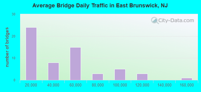
- 2,211,995Total average daily traffic
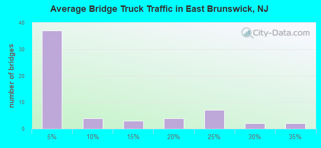
- 259,942Total average daily truck traffic
- National Bridge Inventory (NBI) Registered Bridges for East Brunswick
- No street view available for this location
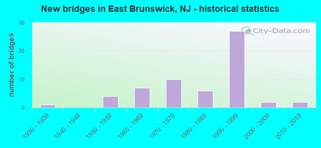
- New bridges - historical statistics
- 11930-1939
- 41950-1959
- 71960-1969
- 101970-1979
- 61980-1989
- 271990-1999
- 22000-2009
- 22010-2019
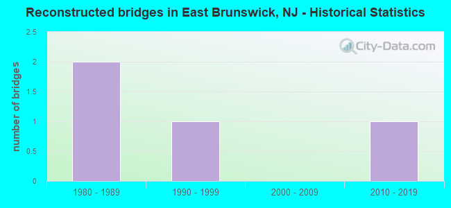
- Reconstructed bridges - Historical Statistics
- 21980-1989
- 11990-1999
- 02000-2009
- 12010-2019
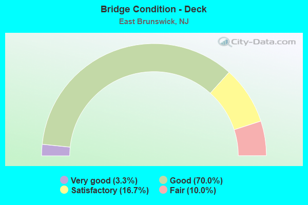
- Bridge Condition - Deck
- 3.3%Very good
- 70.0%Good
- 16.7%Satisfactory
- 10.0%Fair
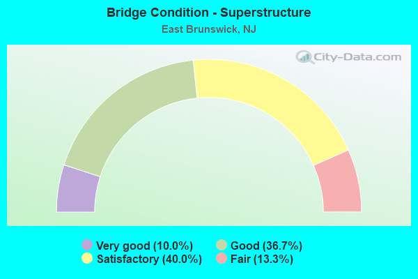
- Bridge Condition - Superstructure
- 10.0%Very good
- 36.7%Good
- 40.0%Satisfactory
- 13.3%Fair
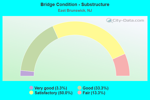
- Bridge Condition - Substructure
- 3.3%Very good
- 33.3%Good
- 50.0%Satisfactory
- 13.3%Fair
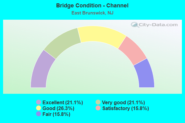
- Bridge Condition - Channel
- 21.1%Excellent
- 21.1%Very good
- 26.3%Good
- 15.8%Satisfactory
- 15.8%Fair
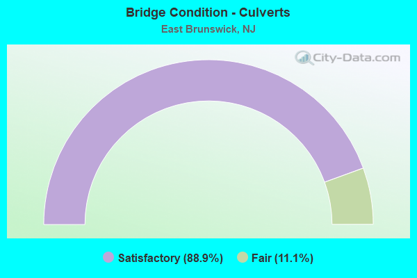
- Bridge Condition - Culverts
- 88.9%Satisfactory
- 11.1%Fair
Find on map >> Show street view
Structure Number: 1212151, Location: 2.5 MILES SOUTH OF NJ TPK (Lat: 40.439581, Lng: -74.393689), Route carried "under" structure: State highway 18, Year Built: 1963, Structure Length: 0. m, Average Daily Traffic: 66,567 (year 2020), Truck Traffic: 4%, Features Intersected: NEW JERSEY ROUTE 18, Facility Carried by Structure: CRANBURY RD (535)
Minimum Vertical Clearance: 4.57m (14.99ft), Kilometerpoint: 59.771, Lanes on structure: 2, Lanes under structure: 8, Material/Design: Steel, Design/Construction: Stringer/Multi-beam, Length of Maximum Span: 23.8m (78.1ft)
Find on map >> Show street view
Structure Number: 1212152, Location: .2 MILES NORTH OF 535 JCT (Lat: 40.442239, Lng: -74.394861), Route carried "under" structure: State highway 18, Year Built: 1963, Structure Length: 0. m, Average Daily Traffic: 62,050 (year 2021), Truck Traffic: 4%, Features Intersected: ROUTE NJ 18, Facility Carried by Structure: MILLTOWN ROAD
Minimum Vertical Clearance: 4.49m (14.73ft), Kilometerpoint: 60.093, Lanes on structure: 2, Lanes under structure: 8, Material/Design: Steel, Design/Construction: Stringer/Multi-beam, Length of Maximum Span: 23.8m (78.1ft)
Find on map >> Show street view
Structure Number: I08334C, Location: .05 MI N INTERCHANGE 9 (Lat: 40.478450, Lng: -74.410264), Route carried "under" structure: Ramp Interstate 95, Year Built: 1988, Structure Length: 0. m, Average Daily Traffic: 157,520 (year 2021), Truck Traffic: 14%, Features Intersected: NJ TPK INT.9 RAMP TW, Facility Carried by Structure: NARICON PLACE
Minimum Vertical Clearance: 4.67m (15.32ft), Kilometerpoint: 61.123, Lanes on structure: 5, Lanes under structure: 2, Material/Design: Steel, Design/Construction: Stringer/Multi-beam, Length of Maximum Span: 17.4m (57.1ft)
Find on map >> Show street view
Structure Number: I8334BR, Location: 0.6 MI S OF US 1 (Lat: 40.477778, Lng: -74.410167), Route carried "under" structure: Ramp Interstate 95, Year Built: 2015, Structure Length: 0. m, Average Daily Traffic: 3,030 (year 2021), Truck Traffic: 9%, Features Intersected: INT. 9 RAMPS TE & WT, Facility Carried by Structure: NJ ROUTE 18
Minimum Vertical Clearance: 4.75m (15.58ft), Kilometerpoint: 61.268, Lanes on structure: 9, Lanes under structure: 3, Toll: On toll road, Material/Design: Steel, Design/Construction: Stringer/Multi-beam, Length of Maximum Span: 25.6m (84.0ft)
Find on map >> Show street view
Structure Number: M07818, Location: 4.2 MI NORTH OF INT 8A (Lat: 40.410692, Lng: -74.449428), Route carried "under" structure: Interstate 95, Year Built: 1990, Structure Length: 0. m, Average Daily Traffic: 93,672 (year 2021), Truck Traffic: 20%, Features Intersected: NJTPK NSO NSI SNO SNI, Facility Carried by Structure: CHURCH LANE
Minimum Vertical Clearance: 4.98m (16.34ft), Kilometerpoint: 52.867, Lanes on structure: 2, Lanes under structure: 13, Toll: On toll road, Material/Design: Steel continuous, Design/Construction: Stringer/Multi-beam, Length of Maximum Span: 31.7m (104.0ft)
Find on map >> Show street view
Structure Number: M07846, Location: 4.5 MI NORTH OF INT 8A (Lat: 40.414444, Lng: -74.446694), Route carried "under" structure: Interstate 95, Year Built: 1990, Structure Length: 0. m, Average Daily Traffic: 45,116 (year 2021), Truck Traffic: 20%, Features Intersected: NJ TPK SNO ROADWAY, Facility Carried by Structure: NJ TPK SISA RAMP
Minimum Vertical Clearance: 4.85m (15.91ft), Kilometerpoint: 62.539, Lanes on structure: 1, Lanes under structure: 4, Toll: On toll road, Material/Design: Steel, Design/Construction: Stringer/Multi-beam, Length of Maximum Span: 39.0m (128.0ft)
Find on map >> Show street view
Structure Number: M07904, Location: 5 MI NORTH OF INT 8A (Lat: 40.421711, Lng: -74.441867), Route carried "under" structure: Interstate 95, Year Built: 1990, Structure Length: 0. m, Average Daily Traffic: 45,116 (year 2021), Truck Traffic: 1%, Features Intersected: NJ TPK SNO ROADWAY, Facility Carried by Structure: NJ TPK SANI RWY
Minimum Vertical Clearance: 4.82m (15.81ft), Kilometerpoint: 54.525, Lanes on structure: 1, Lanes under structure: 2, Toll: On toll road, Material/Design: Steel, Design/Construction: Stringer/Multi-beam, Length of Maximum Span: 32.9m (107.9ft)
Find on map >> Show street view
Structure Number: M0793, Location: 4 MI SOUTH OF INT 9 (Lat: 40.425333, Lng: -74.440644), Route carried "under" structure: Interstate 95, Year Built: 1990, Structure Length: 0. m, Average Daily Traffic: 46,841 (year 2021), Truck Traffic: 14%, Features Intersected: NJ TPK NSO NSI SNI SNO *, Facility Carried by Structure: HARDENBURG LANE *
Minimum Vertical Clearance: 5.03m (16.50ft), Kilometerpoint: 54.686, Lanes on structure: 2, Lanes under structure: 13, Toll: On toll road, Material/Design: Steel continuous, Design/Construction: Stringer/Multi-beam, Length of Maximum Span: 30.5m (100.1ft)
Find on map >> Show street view
Structure Number: M07980R, Location: 3.5 MI SOUTH OF INT 9 (Lat: 40.431597, Lng: -74.435597), Route carried "under" structure: Interstate 95, Year Built: 1990, Structure Length: 0. m, Average Daily Traffic: 45,116 (year 2021), Truck Traffic: 15%, Features Intersected: NJ TPK NSO-NSI-SNI-SNO, Facility Carried by Structure: DUTCH ROAD
Minimum Vertical Clearance: 5.05m (16.57ft), Kilometerpoint: 55.442, Lanes on structure: 2, Lanes under structure: 10, Toll: On toll road, Material/Design: Steel continuous, Design/Construction: Stringer/Multi-beam, Length of Maximum Span: 24.4m (80.1ft)
Find on map >> Show street view
Structure Number: M08158, Location: 1.5 MI S INT. 9 (Lat: 40.454667, Lng: -74.420389), Route carried "under" structure: City street , Year Built: 1950, Structure Length: 0. m, Average Daily Traffic: 20,822 (year 2021), Truck Traffic: 4%, Features Intersected: TICES LANE, Facility Carried by Structure: NSI & SNI RDWY
Minimum Vertical Clearance: 4.98m (16.34ft), Kilometerpoint: 1.674, Lanes on structure: 6, Lanes under structure: 2, Material/Design: Steel, Design/Construction: Stringer/Multi-beam, Length of Maximum Span: 11.6m (38.1ft)
Find on map >> Show street view
Structure Number: M08158N, Location: 1.5 MI SOUTH OF INT 9 (Lat: 40.454528, Lng: -74.419944), Route carried "under" structure: City street , Year Built: 1990, Structure Length: 0. m, Average Daily Traffic: 20,822 (year 2021), Truck Traffic: 4%, Features Intersected: TICES LANE, Facility Carried by Structure: NJ TPK SNO ROADWAY
Minimum Vertical Clearance: 5.11m (16.77ft), Kilometerpoint: 1.674, Lanes on structure: 3, Lanes under structure: 2, Material/Design: Steel, Design/Construction: Stringer/Multi-beam, Length of Maximum Span: 11.9m (39.0ft)
Find on map >> Show street view
Structure Number: M08158S, Location: 1.5 MI SOUTH OF INT 9 (Lat: 40.454722, Lng: -74.420583), Route carried "under" structure: City street , Year Built: 1990, Structure Length: 0. m, Average Daily Traffic: 20,822 (year 2021), Truck Traffic: 4%, Features Intersected: TICES LANE, Facility Carried by Structure: NJ TPK NSO ROADWAY
Minimum Vertical Clearance: 5.18m (16.99ft), Kilometerpoint: 1.674, Lanes on structure: 3, Lanes under structure: 2, Toll: On toll road, Material/Design: Steel, Design/Construction: Stringer/Multi-beam, Length of Maximum Span: 11.9m (39.0ft)
Find on map >> Show street view
Structure Number: M08215R, Location: 1.2 MI SOUTH OF INT 9 (Lat: 40.462581, Lng: -74.415950), Route carried "under" structure: Interstate 95, Year Built: 1990, Structure Length: 0. m, Average Daily Traffic: 45,116 (year 2021), Truck Traffic: 9%, Features Intersected: NJ TPK, Facility Carried by Structure: SULLIVAN WAY
Minimum Vertical Clearance: 5.13m (16.83ft), Kilometerpoint: 59.224, Lanes on structure: 2, Lanes under structure: 12, Toll: On toll road, Material/Design: Steel continuous, Design/Construction: Stringer/Multi-beam, Length of Maximum Span: 20.7m (67.9ft)
Find on map >> Show street view
Structure Number: M08295, Location: 0.3 MI S OF INT. 9 (Lat: 40.473244, Lng: -74.409536), Route carried "under" structure: ServiceInterstate , Year Built: 1974, Structure Length: 0. m, Average Daily Traffic: 54 (year 2021), Truck Traffic: 1%, Features Intersected: NJTPK, Facility Carried by Structure: NJ ROUTE 18
Minimum Vertical Clearance: 4.09m (13.42ft), Kilometerpoint: 59.803, Lanes on structure: 6, Lanes under structure: 1, Material/Design: Steel, Design/Construction: Stringer/Multi-beam, Length of Maximum Span: 40.8m (133.9ft)
Find on map >> Show street view
Structure Number: M08295, Location: 0.3 MI S OF INT. 9 (Lat: 40.473244, Lng: -74.409536), Route carried "under" structure: County highway , Year Built: 1974, Structure Length: 0. m, Average Daily Traffic: 562 (year 2021), Truck Traffic: 3%, Features Intersected: NJTPK, Facility Carried by Structure: NJ ROUTE 18
Minimum Vertical Clearance: 4.42m (14.50ft), Kilometerpoint: 0.129, Lanes on structure: 6, Lanes under structure: 2, Material/Design: Steel, Design/Construction: Stringer/Multi-beam, Length of Maximum Span: 40.8m (133.9ft)
Find on map >> Show street view
Structure Number: M08295, Location: 0.3 MI S OF INT. 9 (Lat: 40.473244, Lng: -74.409536), Route carried "under" structure: Interstate 95, Year Built: 1974, Structure Length: 0. m, Average Daily Traffic: 90,936 (year 2021), Truck Traffic: 20%, Features Intersected: NJTPK, Facility Carried by Structure: NJ ROUTE 18
Minimum Vertical Clearance: 5.23m (17.16ft), Kilometerpoint: 59.803, Lanes on structure: 6, Lanes under structure: 12, Material/Design: Steel, Design/Construction: Stringer/Multi-beam, Length of Maximum Span: 40.8m (133.9ft)
Find on map >> Show street view
Structure Number: M08325, Location: .05 MI SOUTH OF INT 9 (Lat: 40.476097, Lng: -74.405839), Route carried "under" structure: Interstate 95, Year Built: 1974, Structure Length: 0. m, Average Daily Traffic: 55,580 (year 2021), Truck Traffic: 28%, Features Intersected: NJ TPK(I-95) SNO ROADWAY, Facility Carried by Structure: NJTPK INT9 RMP SIT
Minimum Vertical Clearance: 4.93m (16.17ft), Kilometerpoint: 60.994, Lanes on structure: 1, Lanes under structure: 3, Toll: On toll road, Material/Design: Steel, Design/Construction: Stringer/Multi-beam, Length of Maximum Span: 36.9m (121.1ft)
Find on map >> Show street view
Structure Number: M0833, Location: AT INTERCHANGE 9 (Lat: 40.477350, Lng: -74.406378), Route carried "under" structure: Interstate 95, Year Built: 1990, Structure Length: 0. m, Average Daily Traffic: 45,121 (year 2021), Truck Traffic: 21%, Features Intersected: NJ TPK NSO RWY, Facility Carried by Structure: NJ TPK TSI RAMP
Minimum Vertical Clearance: 5.00m (16.40ft), Kilometerpoint: 61.075, Lanes on structure: 1, Lanes under structure: 3, Toll: On toll road, Material/Design: Steel continuous, Design/Construction: Stringer/Multi-beam, Length of Maximum Span: 34.4m (112.9ft)
Find on map >> Show street view
Structure Number: M08336, Location: .05 MI NORTH OF INT 9 (Lat: 40.477261, Lng: -74.404567), Route carried "under" structure: Interstate 95, Year Built: 1973, Structure Length: 0. m, Average Daily Traffic: 55,580 (year 2021), Truck Traffic: 28%, Features Intersected: NJTPK (I-95) SNO ROADWAY, Facility Carried by Structure: NJTPK INT 9 RP TNI
Minimum Vertical Clearance: 5.03m (16.50ft), Kilometerpoint: 61.171, Lanes on structure: 1, Lanes under structure: 3, Toll: On toll road, Material/Design: Steel, Design/Construction: Stringer/Multi-beam, Length of Maximum Span: 29.9m (98.1ft)
Find on map >> Show street view
Structure Number: M08342, Location: .1 MI NORTH OF INT 9 (Lat: 40.478344, Lng: -74.405786), Route carried "under" structure: Interstate 95, Year Built: 1973, Structure Length: 0. m, Average Daily Traffic: 44,227 (year 2021), Truck Traffic: 14%, Features Intersected: NJ TPK NSO NSI SNI SNO*, Facility Carried by Structure: NJ TPK ST-TN RAMPS
Minimum Vertical Clearance: 8.46m (27.76ft), Kilometerpoint: 61.268, Lanes on structure: 3, Lanes under structure: 14, Toll: On toll road, Material/Design: Steel, Design/Construction: Stringer/Multi-beam, Length of Maximum Span: 35.7m (117.1ft)