Bridge Statistics for East Fishkill, New York (NY)
Condition, Traffic, Stress, Structural Evaluation, Project Costs
- National Bridge Inventory (NBI) Statistics
- 56Number of bridges
- 472ft / 144mTotal length
- $125,568,000Total costs
- 593,279Total average daily traffic
- 34,237Total average daily truck traffic
- National Bridge Inventory (NBI) Registered Bridges for East Fishkill
- No street view available for this location
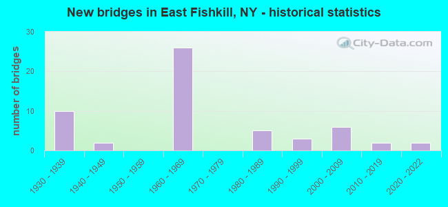
- New bridges - historical statistics
- 101930-1939
- 21940-1949
- 261960-1969
- 51980-1989
- 31990-1999
- 62000-2009
- 22010-2019
- 22020-2022
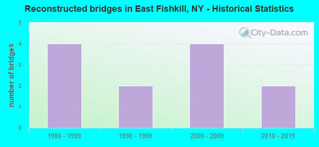
- Reconstructed bridges - Historical Statistics
- 41980-1989
- 21990-1999
- 42000-2009
- 22010-2019
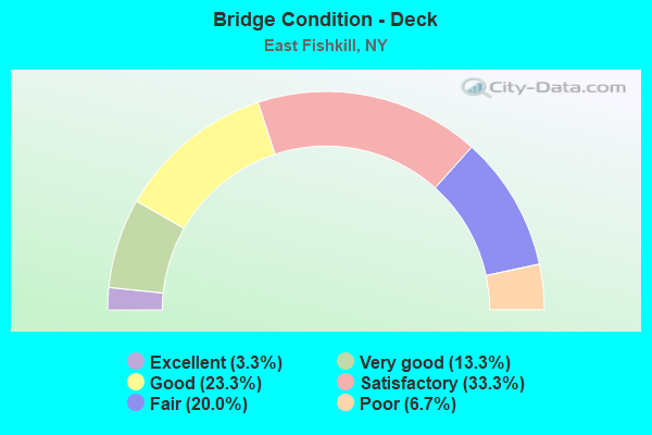
- Bridge Condition - Deck
- 3.3%Excellent
- 13.3%Very good
- 23.3%Good
- 33.3%Satisfactory
- 20.0%Fair
- 6.7%Poor

- Bridge Condition - Superstructure
- 6.1%Excellent
- 18.2%Very good
- 27.3%Good
- 27.3%Satisfactory
- 21.2%Fair
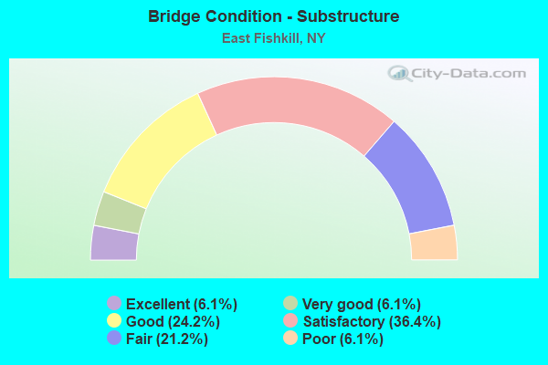
- Bridge Condition - Substructure
- 6.1%Excellent
- 6.1%Very good
- 24.2%Good
- 36.4%Satisfactory
- 21.2%Fair
- 6.1%Poor
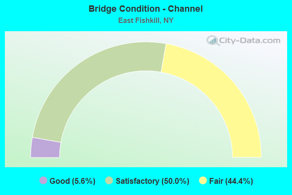
- Bridge Condition - Channel
- 5.6%Good
- 50.0%Satisfactory
- 44.4%Fair
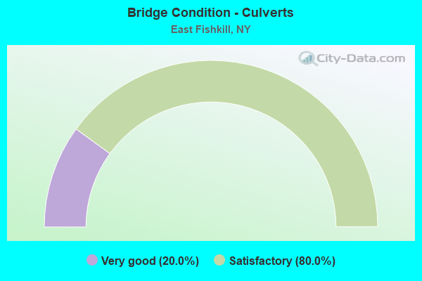
- Bridge Condition - Culverts
- 20.0%Very good
- 80.0%Satisfactory
Find on map >> Show street view
Structure Number: 102685, Location: 1.5 MI E JCT RTS 52+82 (Lat: 41.538581, Lng: -73.843267), Route carried "on" structure: State highway 52, Year Built: 1935, Status: Open, Structure Length: 1.34m (4.40ft), Average Daily Traffic: 9,190 (year 2018), Truck Traffic: 3%, Average Future Daily Traffic: 9,233 (year 2040), Design Load: H 20, Features Intersected: WICOPEE CREEK
Minimum Vertical Clearance: 30+ m (98+ ft), Kilometerpoint: 14.224, Lanes on structure: 2, Base Highway Network: Yes, Owner: State Highway Agency, Approaching Roadway Width: 9.1m (29.9ft), Skew: 2 degrees, Material/Design: Concrete, Design/Construction: Tee Beam, Number Of Spans In Main Unit: 1, Length of Maximum Span: 12.1m (39.7ft), Curb-To-Curb Width: 7.9m (25.9ft), Out-to-Out Width: 8.8m (28.9ft)
Condition: Deck: Satisfactory, Superstructure: Fair, Substructure: Satisfactory, Channel: Fair, Operating Rating: 59.0 metric tons, Method Used To Determine Operating Rating: Load Factor (LF), Inventory Rating: 35.4 metric tons, Method Used To Determine Inventory Rating: Load Factor (LF), Structural Evaluation: Somewhat better than minimum adequacy, Deck Geometry: High priority of replacement, Waterway Adequacy: Superior to present desirable criteria, Approach Roadway Alignment: Meets minimum limits, Length Of Structure Improvement: 1.34m (4.40ft), Designated Inspection Frequency: Every 24 months, Underwater Inspection Frequency: Every 60 months, Inspection Date: June 2020, Underwater Inspection Date: June 2019, Bridge Improvement Cost: $533,000, Roadway Improvement Cost: $312,000, Total Project Cost: $845,000 ( Estimate for 2021), Deck Structure Type: Concrete Cast-file-Place, Wearing Surface/Protective System: Wearing Surface: Bituminous
Find on map >> Show street view
Structure Number: 102686, Location: .1 MI E JCT SH 52 & SH376 (Lat: 41.553675, Lng: -73.793853), Route carried "on" structure: State highway 52, Year Built: 1935, Status: Open, Structure Length: 1.01m (3.31ft), Average Daily Traffic: 11,373 (year 2018), Truck Traffic: 5%, Average Future Daily Traffic: 11,426 (year 2040), Design Load: H 20, Features Intersected: GAYHEAD POND INLT
Minimum Vertical Clearance: 30+ m (98+ ft), Kilometerpoint: 19.034, Lanes on structure: 2, Base Highway Network: Yes, Owner: State Highway Agency, Approaching Roadway Width: 9.1m (29.9ft), Material/Design: Concrete, Design/Construction: Tee Beam, Number Of Spans In Main Unit: 1, Length of Maximum Span: 9.1m (29.9ft), Curb-To-Curb Width: 7.9m (25.9ft), Out-to-Out Width: 8.8m (28.9ft)
Condition: Deck: Fair, Superstructure: Satisfactory, Substructure: Fair, Channel: Fair, Operating Rating: 64.4 metric tons, Method Used To Determine Operating Rating: Load Factor (LF), Inventory Rating: 39.0 metric tons, Method Used To Determine Inventory Rating: Load Factor (LF), Structural Evaluation: Somewhat better than minimum adequacy, Deck Geometry: High priority of replacement, Waterway Adequacy: Meets minimum limits, Approach Roadway Alignment: Meets minimum limits, Length Of Structure Improvement: 1.00m (3.28ft), Designated Inspection Frequency: Every 24 months, Inspection Date: April 2021, Bridge Improvement Cost: $366,000, Roadway Improvement Cost: $214,000, Total Project Cost: $580,000 ( Estimate for 2021), Deck Structure Type: Concrete Cast-file-Place, Wearing Surface/Protective System: Wearing Surface: Bituminous
Find on map >> Show street view
Structure Number: 1026879, Location: JCT TSP & RTE 52 (Lat: 41.557853, Lng: -73.780528), Route carried "on" structure: State highway 987G, Year Built: 1937, Status: Open, Structure Length: 1.49m (4.89ft), Average Daily Traffic: 30,092 (year 2020), Average Future Daily Traffic: 42,450 (year 2040), Design Load: H 20, Features Intersected: RTE 52
Minimum Vertical Clearance: 30+ m (98+ ft), Kilometerpoint: 7.015, Lanes on structure: 4, Lanes under structure: 2, Base Highway Network: Yes, Owner: State Highway Agency, Approaching Roadway Width: 12.8m (42.0ft), Skew: 22 degrees, Material/Design: Concrete, Design/Construction: Frame, Number Of Spans In Main Unit: 1, Length of Maximum Span: 14.6m (47.9ft), Curb-To-Curb Width: 13.0m (42.7ft), Out-to-Out Width: 14.6m (47.9ft)
Condition: Superstructure: Fair, Substructure: Fair, Operating Rating: 56.5 metric tons, Method Used To Determine Operating Rating: Field evaluation and documented engineering judgment, Inventory Rating: 21.0 metric tons, Method Used To Determine Inventory Rating: Field evaluation and documented engineering judgment, Structural Evaluation: Somewhat better than minimum adequacy, Deck Geometry: High priority of replacement, Underclear: Somewhat better than minimum adequacy, Approach Roadway Alignment: Meets minimum limits, Length Of Structure Improvement: 1.49m (4.89ft), Designated Inspection Frequency: Every 24 months, Inspection Date: July 2021, Bridge Improvement Cost: $1,576,000, Roadway Improvement Cost: $923,000, Total Project Cost: $2,499,000 ( Estimate for 2021)
Find on map >> Show street view
Structure Number: 10323, Location: .3 MI N JCT SH 82 & SH376 (Lat: 41.583397, Lng: -73.804069), Route carried "on" structure: State highway 82, Year Built: 1936, Status: Open, Structure Length: 3.51m (11.52ft), Average Daily Traffic: 14,256 (year 2020), Truck Traffic: 5%, Average Future Daily Traffic: 17,318 (year 2040), Design Load: H 20, Features Intersected: Dutchess Rail Trail, MNR
Minimum Vertical Clearance: 30+ m (98+ ft), Kilometerpoint: 7.321, Lanes on structure: 2, Base Highway Network: Yes, Owner: State Highway Agency, Approaching Roadway Width: 10.4m (34.1ft), Material/Design: Steel, Design/Construction: Girder and Floorbeam System, Number Of Spans In Main Unit: 1, Length of Maximum Span: 33.8m (110.9ft), Curb or Sidewalk Widths: Left: 1.5m (4.9ft), Right: 0.0m, Curb-To-Curb Width: 7.7m (25.3ft), Out-to-Out Width: 9.4m (30.8ft)
Condition: Deck: Poor, Superstructure: Fair, Substructure: Satisfactory, Operating Rating: 82.6 metric tons, Method Used To Determine Operating Rating: Load Factor (LF), Inventory Rating: 49.0 metric tons, Method Used To Determine Inventory Rating: Load Factor (LF), Structural Evaluation: Somewhat better than minimum adequacy, Deck Geometry: High priority of replacement, Underclear: Somewhat better than minimum adequacy, Approach Roadway Alignment: Meets minimum limits, Length Of Structure Improvement: 3.50m (11.48ft), Designated Inspection Frequency: Every 24 months, Critical Feature Inspection Frequency: Every 24 months, Inspection Date: July 2021, Critical Feature Inspection Date: July 2021, Bridge Improvement Cost: $2,119,000, Roadway Improvement Cost: $1,241,000, Total Project Cost: $3,359,000 ( Estimate for 2021), Deck Structure Type: Concrete Cast-file-Place, Wearing Surface/Protective System: Wearing Surface: Bituminous
Find on map >> Show street view
Structure Number: 1032319, Location: JCT TSP & RTE 82 (Lat: 41.625350, Lng: -73.774297), Route carried "on" structure: Other road 987G, Year Built: 1938, Status: Open, Structure Length: 1.25m (4.10ft), Average Daily Traffic: 16,584 (year 2020), Average Future Daily Traffic: 23,395 (year 2040), Design Load: HS 20, Features Intersected: RTE 82
Minimum Vertical Clearance: 30+ m (98+ ft), Kilometerpoint: 15.559, Lanes on structure: 4, Lanes under structure: 2, Base Highway Network: Yes, Owner: State Highway Agency, Approaching Roadway Width: 14.6m (47.9ft), Skew: 21 degrees, Material/Design: Concrete, Design/Construction: Frame, Number Of Spans In Main Unit: 1, Length of Maximum Span: 10.1m (33.1ft), Curb-To-Curb Width: 14.9m (48.9ft), Out-to-Out Width: 16.6m (54.5ft)
Condition: Superstructure: Satisfactory, Substructure: Satisfactory, Operating Rating: 79.7 metric tons, Method Used To Determine Operating Rating: Field evaluation and documented engineering judgment, Inventory Rating: 32.7 metric tons, Method Used To Determine Inventory Rating: Field evaluation and documented engineering judgment, Structural Evaluation: Equal to present minimum criteria, Deck Geometry: High priority of replacement, Underclear: High priority of corrective action, Approach Roadway Alignment: Meets minimum limits, Length Of Structure Improvement: 1.24m (4.07ft), Designated Inspection Frequency: Every 24 months, Inspection Date: July 2021, Bridge Improvement Cost: $1,770,000, Roadway Improvement Cost: $1,036,000, Total Project Cost: $2,806,000 ( Estimate for 2021)
Find on map >> Show street view
Structure Number: 103253, Location: 2.4 MI E JCT I84 & US 9 (Lat: 41.530514, Lng: -73.845294), Route carried "on" structure: Other road , Year Built: 1963, Status: Open, Structure Length: 9.63m (31.59ft), Average Daily Traffic: 2,949 (year 2014), Truck Traffic: 4%, Average Future Daily Traffic: 4,129 (year 2034), Design Load: H 20, Features Intersected: 84I84I 82021084-WB, RTE, Facility Carried by Structure: FISHKILL HOOK RD
Minimum Vertical Clearance: 30+ m (98+ ft), Kilometerpoint: 0.869, Lanes on structure: 2, Lanes under structure: 4, Owner: State Highway Agency, Approaching Roadway Width: 8.5m (27.9ft), Material/Design: Steel, Design/Construction: Stringer/Multi-beam, Number Of Spans In Main Unit: 6, Length of Maximum Span: 18.2m (59.7ft), Curb-To-Curb Width: 7.3m (24.0ft), Out-to-Out Width: 8.9m (29.2ft)
Condition: Deck: Satisfactory, Superstructure: Good, Substructure: Satisfactory, Operating Rating: 74.4 metric tons, Method Used To Determine Operating Rating: Load Factor (LF), Inventory Rating: 44.5 metric tons, Method Used To Determine Inventory Rating: Load Factor (LF), Structural Evaluation: Equal to present minimum criteria, Deck Geometry: High priority of replacement, Underclear: High priority of corrective action, Approach Roadway Alignment: Equal to present desirable criteria, Length Of Structure Improvement: 9.63m (31.59ft), Designated Inspection Frequency: Every 24 months, Inspection Date: September 2021, Bridge Improvement Cost: $3,168,000, Roadway Improvement Cost: $1,855,000, Total Project Cost: $5,024,000 ( Estimate for 2021), Deck Structure Type: Concrete Cast-file-Place, Wearing Surface/Protective System: Wearing Surface: Integral Concrete
Find on map >> Show street view
Structure Number: 1032541, Location: 2.8 MI E JCT RTS I84+9 (Lat: 41.532125, Lng: -73.839364), Route carried "on" structure: Interstate 84, Year Built: 1963, Status: Open, Structure Length: 1.04m (3.41ft), Average Daily Traffic: 24,544 (year 1999), Truck Traffic: 15%, Design Load: HS 20, Features Intersected: WICCOPEE CREEK
Minimum Vertical Clearance: 30+ m (98+ ft), Kilometerpoint: 14.095, Lanes on structure: 2, Base Highway Network: Yes, Owner: State Highway Agency, Approaching Roadway Width: 12.5m (41.0ft), Skew: 1 degrees, Material/Design: Concrete continuous, Design/Construction: Culvert, Number Of Spans In Main Unit: 2, Length of Maximum Span: 4.8m (15.7ft)
Condition: Channel: Satisfactory, Culverts: Satisfactory, Operating Rating: 78.9 metric tons, Method Used To Determine Operating Rating: Load Factor (LF), Inventory Rating: 47.2 metric tons, Method Used To Determine Inventory Rating: Load Factor (LF), Structural Evaluation: Equal to present minimum criteria, Waterway Adequacy: High priority of corrective action, Approach Roadway Alignment: Equal to present desirable criteria, Length Of Structure Improvement: 1.03m (3.38ft), Designated Inspection Frequency: Every 24 months, Inspection Date: April 2021, Bridge Improvement Cost: $626,000, Roadway Improvement Cost: $367,000, Total Project Cost: $993,000 ( Estimate for 2021)
Find on map >> Show street view
Structure Number: 1032542, Location: 2.8 MI E JCT RTS I84+9 (Lat: 41.531778, Lng: -73.839197), Route carried "on" structure: Interstate 84, Year Built: 1963, Status: Open, Structure Length: 1.04m (3.41ft), Average Daily Traffic: 20,558 (year 2019), Truck Traffic: 16%, Average Future Daily Traffic: 34,813 (year 2040), Design Load: HS 20, Features Intersected: WICCOPEE CREEK
Minimum Vertical Clearance: 30+ m (98+ ft), Kilometerpoint: 14.063, Lanes on structure: 2, Base Highway Network: Yes, Owner: State Highway Agency, Approaching Roadway Width: 12.5m (41.0ft), Material/Design: Concrete continuous, Design/Construction: Culvert, Number Of Spans In Main Unit: 2, Length of Maximum Span: 4.8m (15.7ft)
Condition: Channel: Satisfactory, Culverts: Satisfactory, Operating Rating: 78.9 metric tons, Method Used To Determine Operating Rating: Load Factor (LF), Inventory Rating: 47.2 metric tons, Method Used To Determine Inventory Rating: Load Factor (LF), Structural Evaluation: Equal to present minimum criteria, Waterway Adequacy: Meets minimum limits, Approach Roadway Alignment: Equal to present desirable criteria, Length Of Structure Improvement: 1.03m (3.38ft), Designated Inspection Frequency: Every 24 months, Inspection Date: April 2021, Bridge Improvement Cost: $624,000, Roadway Improvement Cost: $366,000, Total Project Cost: $990,000 ( Estimate for 2021)
Find on map >> Show street view
Structure Number: 103255, Location: 4.1 MI E JCT RTS I84+9 (Lat: 41.529781, Lng: -73.812194), Route carried "on" structure: Other road , Year Built: 1963, Year Reconstructed: 1990, Status: Open, Structure Length: 8.14m (26.71ft), Truck Traffic: 10%, Design Load: HS 20+Mod, Features Intersected: 84I84I 82021101 WB, RTE, Facility Carried by Structure: LIMEKILN RD
Minimum Vertical Clearance: 30+ m (98+ ft), Kilometerpoint: 1.384, Lanes on structure: 5, Lanes under structure: 5, Owner: State Highway Agency, Approaching Roadway Width: 19.2m (63.0ft), Skew: 1 degrees, Material/Design: Steel, Design/Construction: Stringer/Multi-beam, Number Of Spans In Main Unit: 4, Length of Maximum Span: 26.2m (86.0ft), Curb-To-Curb Width: 19.2m (63.0ft), Out-to-Out Width: 20.1m (65.9ft)
Condition: Deck: Good, Superstructure: Very good, Substructure: Good, Operating Rating: 63.5 metric tons, Method Used To Determine Operating Rating: Load Factor (LF), Inventory Rating: 37.2 metric tons, Method Used To Determine Inventory Rating: Load Factor (LF), Structural Evaluation: Better than present minimum criteria, Deck Geometry: Meets minimum limits, Underclear: High priority of corrective action, Approach Roadway Alignment: Equal to present desirable criteria, Length Of Structure Improvement: 8.13m (26.67ft), Designated Inspection Frequency: Every 24 months, Inspection Date: August 2020, Bridge Improvement Cost: $6,091,000, Roadway Improvement Cost: $3,567,000, Total Project Cost: $9,658,000 ( Estimate for 2021), Deck Structure Type: Concrete Cast-file-Place, Wearing Surface/Protective System: Wearing Surface: Integral Concrete, Deck Protection: Epoxy Coated Reinforcing
Find on map >> Show street view
Structure Number: 103256, Location: 5.0 MI E JCT RTS I84+9 (Lat: 41.532606, Lng: -73.795017), Route carried "on" structure: Other road , Year Built: 1963, Status: Open, Structure Length: 8.60m (28.22ft), Average Daily Traffic: 1,498 (year 2020), Truck Traffic: 8%, Average Future Daily Traffic: 2,097 (year 2040), Design Load: H 20, Features Intersected: 84I 84I82021111 WB, RTE, Facility Carried by Structure: SHENANDOAH ROAD
Minimum Vertical Clearance: 30+ m (98+ ft), Kilometerpoint: 2.510, Lanes on structure: 2, Lanes under structure: 4, Owner: State Highway Agency, Approaching Roadway Width: 9.1m (29.9ft), Skew: 2 degrees, Material/Design: Steel, Design/Construction: Stringer/Multi-beam, Number Of Spans In Main Unit: 5, Length of Maximum Span: 18.5m (60.7ft), Curb or Sidewalk Widths: Left: 0.5m (1.6ft), Right: 0.5m (1.6ft), Curb-To-Curb Width: 8.5m (27.9ft), Out-to-Out Width: 10.1m (33.1ft)
Condition: Deck: Satisfactory, Superstructure: Good, Substructure: Satisfactory, Operating Rating: 84.4 metric tons, Method Used To Determine Operating Rating: Load Factor (LF), Inventory Rating: 50.8 metric tons, Method Used To Determine Inventory Rating: Load Factor (LF), Structural Evaluation: Equal to present minimum criteria, Deck Geometry: Somewhat better than minimum adequacy, Underclear: High priority of corrective action, Approach Roadway Alignment: Equal to present desirable criteria, Length Of Structure Improvement: 8.59m (28.18ft), Designated Inspection Frequency: Every 24 months, Inspection Date: April 2021, Bridge Improvement Cost: $3,333,000, Roadway Improvement Cost: $1,952,000, Total Project Cost: $5,285,000 ( Estimate for 2021), Deck Structure Type: Concrete Cast-file-Place, Wearing Surface/Protective System: Wearing Surface: Integral Concrete
Find on map >> Show street view
Structure Number: 1032571, Location: INT RTS I84(WB)& TSP (Lat: 41.539225, Lng: -73.771878), Route carried "on" structure: Interstate 84, Year Built: 1963, Year Reconstructed: 1989, Status: Open, Structure Length: 10.58m (34.71ft), Average Daily Traffic: 26,344 (year 2009), Truck Traffic: 15%, Design Load: HS 20, Features Intersected: 987G 987G82031029 SB, R
Minimum Vertical Clearance: 30+ m (98+ ft), Kilometerpoint: 19.919, Lanes on structure: 3, Lanes under structure: 6, Base Highway Network: Yes, Owner: State Highway Agency, Approaching Roadway Width: 12.2m (40.0ft), Material/Design: Steel, Design/Construction: Stringer/Multi-beam, Number Of Spans In Main Unit: 6, Length of Maximum Span: 19.8m (65.0ft), Curb-To-Curb Width: 12.3m (40.4ft), Out-to-Out Width: 13.9m (45.6ft)
Condition: Deck: Satisfactory, Superstructure: Satisfactory, Substructure: Fair, Operating Rating: 80.7 metric tons, Method Used To Determine Operating Rating: Load Factor (LF), Inventory Rating: 48.1 metric tons, Method Used To Determine Inventory Rating: Load Factor (LF), Structural Evaluation: Somewhat better than minimum adequacy, Deck Geometry: Meets minimum limits, Underclear: High priority of corrective action, Approach Roadway Alignment: Equal to present desirable criteria, Length Of Structure Improvement: 10.57m (34.68ft), Designated Inspection Frequency: Every 24 months, Inspection Date: July 2021, Bridge Improvement Cost: $5,383,000, Roadway Improvement Cost: $3,152,000, Total Project Cost: $8,535,000 ( Estimate for 2021), Deck Structure Type: Concrete Cast-file-Place, Wearing Surface/Protective System: Wearing Surface: Monolithic Concrete
Find on map >> Show street view
Structure Number: 1032572, Location: INT RTS I84(EB) & TSP (Lat: 41.538708, Lng: -73.771794), Route carried "on" structure: Interstate 84, Year Built: 1963, Year Reconstructed: 1989, Status: Open, Structure Length: 10.91m (35.79ft), Average Daily Traffic: 22,731 (year 2019), Truck Traffic: 15%, Average Future Daily Traffic: 38,492 (year 2040), Design Load: HS 20, Features Intersected: 987G 987G82031029 SB, R
Minimum Vertical Clearance: 30+ m (98+ ft), Kilometerpoint: 19.887, Lanes on structure: 3, Lanes under structure: 6, Base Highway Network: Yes, Owner: State Highway Agency, Approaching Roadway Width: 12.2m (40.0ft), Material/Design: Steel, Design/Construction: Stringer/Multi-beam, Number Of Spans In Main Unit: 6, Length of Maximum Span: 20.7m (67.9ft), Curb-To-Curb Width: 12.9m (42.3ft), Out-to-Out Width: 13.9m (45.6ft)
Condition: Deck: Good, Superstructure: Good, Substructure: Fair, Operating Rating: 81.6 metric tons, Method Used To Determine Operating Rating: Load Factor (LF), Inventory Rating: 49.0 metric tons, Method Used To Determine Inventory Rating: Load Factor (LF), Structural Evaluation: Somewhat better than minimum adequacy, Deck Geometry: Meets minimum limits, Underclear: High priority of corrective action, Approach Roadway Alignment: Equal to present desirable criteria, Length Of Structure Improvement: 10.91m (35.79ft), Designated Inspection Frequency: Every 24 months, Inspection Date: August 2021, Bridge Improvement Cost: $5,543,000, Roadway Improvement Cost: $3,246,000, Total Project Cost: $8,788,000 ( Estimate for 2021), Deck Structure Type: Concrete Cast-file-Place, Wearing Surface/Protective System: Wearing Surface: Monolithic Concrete
Find on map >> Show street view
Structure Number: 104697, Location: 0.1 MI N JCT RTS 376+52 (Lat: 41.555150, Lng: -73.795908), Route carried "on" structure: State highway 376, Year Built: 1935, Status: Open, Structure Length: 0.79m (2.59ft), Average Daily Traffic: 9,722 (year 2018), Truck Traffic: 5%, Average Future Daily Traffic: 12,029 (year 2040), Design Load: H 20, Features Intersected: GAYHEAD POND STREAM
Minimum Vertical Clearance: 30+ m (98+ ft), Kilometerpoint: 0.177, Lanes on structure: 2, Base Highway Network: Yes, Owner: State Highway Agency, Approaching Roadway Width: 9.1m (29.9ft), Material/Design: Steel, Design/Construction: Stringer/Multi-beam, Number Of Spans In Main Unit: 1, Length of Maximum Span: 7.0m (23.0ft), Curb-To-Curb Width: 7.9m (25.9ft), Out-to-Out Width: 8.7m (28.5ft)
Condition: Deck: Fair, Superstructure: Fair, Substructure: Fair, Channel: Fair, Operating Rating: 28.5 metric tons, Method Used To Determine Operating Rating: Load and Resistance Factor Rating (LRFR) rating reported by rating factor(RF) method using HL-93 loadings, Inventory Rating: 22.0 metric tons, Method Used To Determine Inventory Rating: Load and Resistance Factor Rating (LRFR) rating reported by rating factor(RF) method using HL-93 loadings, Structural Evaluation: Somewhat better than minimum adequacy, Deck Geometry: High priority of replacement, Waterway Adequacy: Meets minimum limits, Approach Roadway Alignment: Meets minimum limits, Length Of Structure Improvement: 0.79m (2.59ft), Designated Inspection Frequency: Every 24 months, Inspection Date: October 2021, Bridge Improvement Cost: $879,000, Roadway Improvement Cost: $515,000, Total Project Cost: $1,393,000 ( Estimate for 2021), Deck Structure Type: Concrete Cast-file-Place, Wearing Surface/Protective System: Wearing Surface: Bituminous
Find on map >> Show street view
Structure Number: 104698, Location: 1.5 MI N JCT RTS 376+52 (Lat: 41.571619, Lng: -73.806781), Route carried "on" structure: State highway 376, Year Built: 1947, Year Reconstructed: 1988, Status: Open, Structure Length: 3.41m (11.19ft), Average Daily Traffic: 9,722 (year 2018), Truck Traffic: 5%, Average Future Daily Traffic: 12,029 (year 2040), Design Load: HS 20, Features Intersected: FISHKILL CREEK
Minimum Vertical Clearance: 30+ m (98+ ft), Kilometerpoint: 2.446, Lanes on structure: 2, Base Highway Network: Yes, Owner: State Highway Agency, Approaching Roadway Width: 10.1m (33.1ft), Skew: 3 degrees, Material/Design: Steel, Design/Construction: Stringer/Multi-beam, Number Of Spans In Main Unit: 2, Length of Maximum Span: 16.4m (53.8ft), Curb-To-Curb Width: 9.8m (32.2ft), Out-to-Out Width: 10.4m (34.1ft)
Condition: Deck: Satisfactory, Superstructure: Fair, Substructure: Poor, Channel: Fair, Operating Rating: 76.2 metric tons, Method Used To Determine Operating Rating: Load Factor (LF), Inventory Rating: 45.4 metric tons, Method Used To Determine Inventory Rating: Load Factor (LF), Structural Evaluation: Meets minimum limits, Deck Geometry: Meets minimum limits, Waterway Adequacy: Meets minimum limits, Approach Roadway Alignment: Meets minimum limits, Length Of Structure Improvement: 3.41m (11.19ft), Designated Inspection Frequency: Every 24 months, Inspection Date: April 2020, Bridge Improvement Cost: $2,141,000, Roadway Improvement Cost: $1,254,000, Total Project Cost: $3,395,000 ( Estimate for 2021), Deck Structure Type: Concrete Cast-file-Place, Wearing Surface/Protective System: Wearing Surface: Integral Concrete, Deck Protection: Epoxy Coated Reinforcing
Find on map >> Show street view
Structure Number: 104699, Location: .3 MI N JCT SH 376 & SH82 (Lat: 41.584578, Lng: -73.809181), Route carried "on" structure: State highway 376, Year Built: 2005, Status: Open, Structure Length: 0.79m (2.59ft), Average Daily Traffic: 5,367 (year 2016), Truck Traffic: 5%, Average Future Daily Traffic: 6,640 (year 2040), Design Load: HS 25 or greater, Features Intersected: WHORTLE KILL CREEK
Minimum Vertical Clearance: 30+ m (98+ ft), Kilometerpoint: 4.087, Lanes on structure: 2, Base Highway Network: Yes, Owner: State Highway Agency, Approaching Roadway Width: 9.4m (30.8ft), Material/Design: Concrete, Design/Construction: Frame, Number Of Spans In Main Unit: 1, Length of Maximum Span: 7.4m (24.3ft), Curb-To-Curb Width: 9.4m (30.8ft), Out-to-Out Width: 10.4m (34.1ft)
Condition: Deck: Very good, Superstructure: Very good, Substructure: Very good, Channel: Satisfactory, Operating Rating: 81.6 metric tons, Method Used To Determine Operating Rating: Load Factor (LF), Inventory Rating: 49.0 metric tons, Method Used To Determine Inventory Rating: Load Factor (LF), Structural Evaluation: Equal to present desirable criteria, Deck Geometry: High priority of corrective action, Waterway Adequacy: Equal to present desirable criteria, Approach Roadway Alignment: Equal to present desirable criteria, Length Of Structure Improvement: 0.79m (2.59ft), Designated Inspection Frequency: Every 24 months, Inspection Date: Febuary 2020, Bridge Improvement Cost: $232,000, Roadway Improvement Cost: $136,000, Total Project Cost: $368,000 ( Estimate for 2021), Wearing Surface/Protective System: Wearing Surface: Bituminous
Find on map >> Show street view
Structure Number: 1052351, Location: .9 MI E JCT I84 & TSP (Lat: 41.543503, Lng: -73.754528), Route carried "on" structure: Interstate 84, Year Built: 1968, Status: Open, Structure Length: 3.78m (12.40ft), Average Daily Traffic: 26,344 (year 2009), Truck Traffic: 15%, Design Load: HS 20, Features Intersected: HOSNER MOUNTAIN ROAD
Minimum Vertical Clearance: 30+ m (98+ ft), Kilometerpoint: 21.496, Lanes on structure: 2, Lanes under structure: 2, Base Highway Network: Yes, Owner: State Highway Agency, Approaching Roadway Width: 12.2m (40.0ft), Skew: 2 degrees, Material/Design: Steel, Design/Construction: Stringer/Multi-beam, Number Of Spans In Main Unit: 1, Length of Maximum Span: 36.2m (118.8ft), Curb-To-Curb Width: 11.8m (38.7ft), Out-to-Out Width: 12.7m (41.7ft)
Condition: Deck: Poor, Superstructure: Fair, Substructure: Satisfactory, Operating Rating: 75.3 metric tons, Method Used To Determine Operating Rating: Load Factor (LF), Inventory Rating: 44.5 metric tons, Method Used To Determine Inventory Rating: Load Factor (LF), Structural Evaluation: Somewhat better than minimum adequacy, Deck Geometry: Equal to present minimum criteria, Underclear: Somewhat better than minimum adequacy, Approach Roadway Alignment: Equal to present desirable criteria, Length Of Structure Improvement: 3.77m (12.37ft), Designated Inspection Frequency: Every 24 months, Inspection Date: November 2021, Bridge Improvement Cost: $2,226,000, Roadway Improvement Cost: $1,304,000, Total Project Cost: $3,530,000 ( Estimate for 2021), Deck Structure Type: Concrete Cast-file-Place, Wearing Surface/Protective System: Wearing Surface: Integral Concrete
Find on map >> Show street view
Structure Number: 1052352, Location: .9 MI E JCT I84 & TSP (Lat: 41.543278, Lng: -73.754064), Route carried "on" structure: Interstate 84, Year Built: 1968, Year Reconstructed: 2006, Status: Open, Structure Length: 4.24m (13.91ft), Average Daily Traffic: 17,936 (year 2020), Truck Traffic: 20%, Average Future Daily Traffic: 30,372 (year 2040), Design Load: HS 20, Features Intersected: HOSNER MTN ROAD
Minimum Vertical Clearance: 30+ m (98+ ft), Kilometerpoint: 21.448, Lanes on structure: 2, Lanes under structure: 2, Base Highway Network: Yes, Owner: State Highway Agency, Approaching Roadway Width: 11.9m (39.0ft), Skew: 2 degrees, Material/Design: Steel, Design/Construction: Stringer/Multi-beam, Number Of Spans In Main Unit: 1, Length of Maximum Span: 40.8m (133.9ft), Curb-To-Curb Width: 11.8m (38.7ft), Out-to-Out Width: 12.7m (41.7ft)
Condition: Deck: Satisfactory, Superstructure: Satisfactory, Substructure: Satisfactory, Operating Rating: 67.1 metric tons, Method Used To Determine Operating Rating: Load Factor (LF), Inventory Rating: 39.9 metric tons, Method Used To Determine Inventory Rating: Load Factor (LF), Structural Evaluation: Equal to present minimum criteria, Deck Geometry: Equal to present minimum criteria, Underclear: Meets minimum limits, Approach Roadway Alignment: Equal to present desirable criteria, Length Of Structure Improvement: 4.23m (13.88ft), Designated Inspection Frequency: Every 24 months, Inspection Date: November 2020, Bridge Improvement Cost: $2,426,000, Roadway Improvement Cost: $1,421,000, Total Project Cost: $3,847,000 ( Estimate for 2021), Deck Structure Type: Concrete Cast-file-Place, Wearing Surface/Protective System: Wearing Surface: Integral Concrete
Find on map >> Show street view
Structure Number: 1052361, Location: 2.1 MILES E JCT I84 & TSP (Lat: 41.548386, Lng: -73.732278), Route carried "on" structure: Interstate 84, Year Built: 1968, Year Reconstructed: 2006, Status: Open, Structure Length: 9.78m (32.09ft), Average Daily Traffic: 26,344 (year 2009), Truck Traffic: 15%, Design Load: HS 20, Features Intersected: RTE 52
Minimum Vertical Clearance: 30+ m (98+ ft), Kilometerpoint: 23.427, Lanes on structure: 2, Lanes under structure: 3, Base Highway Network: Yes, Owner: State Highway Agency, Approaching Roadway Width: 14.6m (47.9ft), Material/Design: Steel, Design/Construction: Stringer/Multi-beam, Number Of Spans In Main Unit: 3, Length of Maximum Span: 32.0m (105.0ft), Curb-To-Curb Width: 8.5m (27.9ft), Out-to-Out Width: 10.0m (32.8ft)
Condition: Deck: Satisfactory, Superstructure: Satisfactory, Substructure: Satisfactory, Operating Rating: 55.3 metric tons, Method Used To Determine Operating Rating: Load Factor (LF), Inventory Rating: 33.6 metric tons, Method Used To Determine Inventory Rating: Load Factor (LF), Structural Evaluation: Equal to present minimum criteria, Deck Geometry: High priority of corrective action, Underclear: Equal to present minimum criteria, Approach Roadway Alignment: Equal to present desirable criteria, Length Of Structure Improvement: 9.78m (32.09ft), Designated Inspection Frequency: Every 24 months, Inspection Date: December 2021, Bridge Improvement Cost: $3,608,000, Roadway Improvement Cost: $2,113,000, Total Project Cost: $5,722,000 ( Estimate for 2021), Deck Structure Type: Concrete Cast-file-Place, Wearing Surface/Protective System: Wearing Surface: Integral Concrete
Find on map >> Show street view
Structure Number: 1052362, Location: 2.1 MILES E JCT I84 & TSP (Lat: 41.547958, Lng: -73.732325), Route carried "on" structure: Interstate 84, Year Built: 1968, Year Reconstructed: 2019, Status: Open, Structure Length: 9.14m (29.99ft), Average Daily Traffic: 17,936 (year 2020), Truck Traffic: 20%, Average Future Daily Traffic: 30,372 (year 2040), Design Load: HS 20, Features Intersected: RTE 52
Minimum Vertical Clearance: 30+ m (98+ ft), Kilometerpoint: 23.395, Lanes on structure: 3, Lanes under structure: 3, Base Highway Network: Yes, Owner: State Highway Agency, Approaching Roadway Width: 12.8m (42.0ft), Material/Design: Steel, Design/Construction: Stringer/Multi-beam, Number Of Spans In Main Unit: 3, Length of Maximum Span: 29.8m (97.8ft), Curb-To-Curb Width: 11.6m (38.1ft), Out-to-Out Width: 13.0m (42.7ft)
Condition: Deck: Satisfactory, Superstructure: Satisfactory, Substructure: Satisfactory, Operating Rating: 72.6 metric tons, Method Used To Determine Operating Rating: Load Factor (LF), Inventory Rating: 42.6 metric tons, Method Used To Determine Inventory Rating: Load Factor (LF), Structural Evaluation: Equal to present minimum criteria, Deck Geometry: High priority of replacement, Underclear: Equal to present minimum criteria, Approach Roadway Alignment: Equal to present desirable criteria, Length Of Structure Improvement: 9.14m (29.99ft), Designated Inspection Frequency: Every 24 months, Inspection Date: December 2021, Bridge Improvement Cost: $4,422,000, Roadway Improvement Cost: $2,590,000, Total Project Cost: $7,012,000 ( Estimate for 2021), Deck Structure Type: Concrete Cast-file-Place, Wearing Surface/Protective System: Wearing Surface: Bituminous
Find on map >> Show street view
Structure Number: 105237, Location: 3.1 MI E JCT I84 & TSP (Lat: 41.543678, Lng: -73.714606), Route carried "on" structure: Other road , Year Built: 1968, Year Reconstructed: 2006, Status: Open, Structure Length: 8.41m (27.59ft), Average Daily Traffic: 701 (year 2018), Truck Traffic: 4%, Average Future Daily Traffic: 981 (year 2038), Design Load: HS 20, Features Intersected: 84I 84I82021157 - EB, RT, Facility Carried by Structure: STORMVILLE MOUNTAI
Minimum Vertical Clearance: 30+ m (98+ ft), Kilometerpoint: 2.285, Lanes on structure: 2, Lanes under structure: 5, Owner: State Highway Agency, Approaching Roadway Width: 7.6m (24.9ft), Material/Design: Steel, Design/Construction: Stringer/Multi-beam, Number Of Spans In Main Unit: 3, Length of Maximum Span: 28.9m (94.8ft), Curb-To-Curb Width: 7.8m (25.6ft), Out-to-Out Width: 8.8m (28.9ft)
Condition: Deck: Fair, Superstructure: Satisfactory, Substructure: Good, Operating Rating: 74.4 metric tons, Method Used To Determine Operating Rating: Load Factor (LF), Inventory Rating: 44.5 metric tons, Method Used To Determine Inventory Rating: Load Factor (LF), Structural Evaluation: Equal to present minimum criteria, Deck Geometry: Meets minimum limits, Underclear: High priority of corrective action, Approach Roadway Alignment: Equal to present desirable criteria, Length Of Structure Improvement: 8.41m (27.59ft), Designated Inspection Frequency: Every 24 months, Inspection Date: November 2021, Bridge Improvement Cost: $2,700,000, Roadway Improvement Cost: $1,581,000, Total Project Cost: $4,281,000 ( Estimate for 2021), Deck Structure Type: Concrete Cast-file-Place, Wearing Surface/Protective System: Wearing Surface: Integral Concrete
Find on map >> Show street view
Structure Number: 105239, Location: 5.4 MI E JCT I84+TSP (Lat: 41.520322, Lng: -73.690731), Route carried "on" structure: County highway , Year Built: 1968, Status: Open, Structure Length: 9.17m (30.09ft), Average Daily Traffic: 1,809 (year 2020), Truck Traffic: 7%, Average Future Daily Traffic: 2,238 (year 2040), Design Load: HS 20, Features Intersected: 84I 84I82021177 NB, RTE, Facility Carried by Structure: HOLMES ROAD
Minimum Vertical Clearance: 30+ m (98+ ft), Kilometerpoint: 0.386, Lanes on structure: 2, Lanes under structure: 4, Owner: State Highway Agency, Approaching Roadway Width: 8.2m (26.9ft), Skew: 3 degrees, Material/Design: Steel, Design/Construction: Stringer/Multi-beam, Number Of Spans In Main Unit: 4, Length of Maximum Span: 30.4m (99.7ft), Curb-To-Curb Width: 7.8m (25.6ft), Out-to-Out Width: 8.8m (28.9ft)
Condition: Deck: Good, Superstructure: Good, Substructure: Fair, Operating Rating: 79.8 metric tons, Method Used To Determine Operating Rating: Load Factor (LF), Inventory Rating: 48.1 metric tons, Method Used To Determine Inventory Rating: Load Factor (LF), Structural Evaluation: Somewhat better than minimum adequacy, Deck Geometry: Meets minimum limits, Underclear: High priority of corrective action, Approach Roadway Alignment: Equal to present desirable criteria, Length Of Structure Improvement: 9.17m (30.09ft), Designated Inspection Frequency: Every 24 months, Inspection Date: May 2021, Bridge Improvement Cost: $2,985,000, Roadway Improvement Cost: $1,748,000, Total Project Cost: $4,733,000 ( Estimate for 2021), Deck Structure Type: Concrete Cast-file-Place, Wearing Surface/Protective System: Wearing Surface: Monolithic Concrete
Find on map >> Show street view
Structure Number: 107846, Location: 0.4 Mi NW JCT I-84 & TSP (Lat: 41.544775, Lng: -73.774775), Route carried "on" structure: Other road , Year Built: 2006, Status: Open, Structure Length: 2.41m (7.91ft), Average Daily Traffic: 802 (year 2020), Truck Traffic: 5%, Average Future Daily Traffic: 1,123 (year 2040), Design Load: HL 93, Features Intersected: RTE 987, Facility Carried by Structure: HOSNER MOUNTAIN RO
Minimum Vertical Clearance: 32.69m (107.25ft), Kilometerpoint: 1.496, Lanes on structure: 2, Lanes under structure: 2, Owner: State Highway Agency, Approaching Roadway Width: 8.5m (27.9ft), Material/Design: Steel, Design/Construction: Stringer/Multi-beam, Number Of Spans In Main Unit: 1, Length of Maximum Span: 22.6m (74.1ft), Curb or Sidewalk Widths: Left: 0.0m, Right: 1.7m (5.6ft), Curb-To-Curb Width: 8.4m (27.6ft), Out-to-Out Width: 11.2m (36.7ft)
Condition: Deck: Fair, Superstructure: Very good, Substructure: Good, Operating Rating: 93.4 metric tons, Method Used To Determine Operating Rating: Load Factor (LF), Inventory Rating: 55.3 metric tons, Method Used To Determine Inventory Rating: Load Factor (LF), Structural Evaluation: Better than present minimum criteria, Deck Geometry: Somewhat better than minimum adequacy, Underclear: Meets minimum limits, Approach Roadway Alignment: Equal to present desirable criteria, Length Of Structure Improvement: 2.40m (7.87ft), Designated Inspection Frequency: Every 24 months, Inspection Date: April 2021, Bridge Improvement Cost: $2,025,000, Roadway Improvement Cost: $1,186,000, Total Project Cost: $3,210,000 ( Estimate for 2021), Deck Structure Type: Concrete Cast-file-Place, Wearing Surface/Protective System: Wearing Surface: Integral Concrete
Find on map >> Show street view
Structure Number: 107847, Location: 0.4 Mi NW of I84 & TSP (Lat: 41.544639, Lng: -73.775258), Route carried "on" structure: Other road 987, Year Built: 2006, Status: Open, Structure Length: 2.41m (7.91ft), Average Daily Traffic: 802 (year 2020), Truck Traffic: 5%, Average Future Daily Traffic: 1,123 (year 2040), Design Load: HL 93, Features Intersected: 987G 987G82031036
Minimum Vertical Clearance: 30+ m (98+ ft), Kilometerpoint: 1.448, Lanes on structure: 2, Lanes under structure: 2, Owner: State Highway Agency, Approaching Roadway Width: 8.5m (27.9ft), Material/Design: Steel, Design/Construction: Stringer/Multi-beam, Number Of Spans In Main Unit: 1, Length of Maximum Span: 22.6m (74.1ft), Curb or Sidewalk Widths: Left: 0.0m, Right: 1.7m (5.6ft), Curb-To-Curb Width: 8.4m (27.6ft), Out-to-Out Width: 11.2m (36.7ft)
Condition: Deck: Fair, Superstructure: Very good, Substructure: Good, Operating Rating: 93.4 metric tons, Method Used To Determine Operating Rating: Load Factor (LF), Inventory Rating: 55.3 metric tons, Method Used To Determine Inventory Rating: Load Factor (LF), Structural Evaluation: Better than present minimum criteria, Deck Geometry: Somewhat better than minimum adequacy, Underclear: High priority of corrective action, Approach Roadway Alignment: Equal to present desirable criteria, Length Of Structure Improvement: 2.40m (7.87ft), Designated Inspection Frequency: Every 24 months, Inspection Date: April 2021, Bridge Improvement Cost: $1,978,000, Roadway Improvement Cost: $1,158,000, Total Project Cost: $3,136,000 ( Estimate for 2021), Deck Structure Type: Concrete Cast-file-Place, Wearing Surface/Protective System: Wearing Surface: Integral Concrete
Find on map >> Show street view
Structure Number: 109135, Location: NW QUAD RAMPS I84+TSP INT (Lat: 41.540653, Lng: -73.773425), Route carried "on" structure: Ramp Interstate 84, Year Built: 1962, Status: Open, Structure Length: 0.82m (2.69ft), Average Daily Traffic: 3,580 (year 2020), Truck Traffic: 15%, Average Future Daily Traffic: 6,062 (year 2040), Design Load: HS 20, Features Intersected: STERN STREAM
Minimum Vertical Clearance: 30+ m (98+ ft), Kilometerpoint: 0.225, Lanes on structure: 1, Owner: State Highway Agency, Approaching Roadway Width: 4.3m (14.1ft), Skew: 4 degrees, Material/Design: Concrete, Design/Construction: Culvert, Number Of Spans In Main Unit: 1, Length of Maximum Span: 7.3m (24.0ft)
Condition: Channel: Fair, Culverts: Satisfactory, Inventory Rating: 51.7 metric tons, Method Used To Determine Inventory Rating: Allowable Stress (AS), Structural Evaluation: Equal to present minimum criteria, Waterway Adequacy: Meets minimum limits, Approach Roadway Alignment: Equal to present desirable criteria, Length Of Structure Improvement: 0.82m (2.69ft), Designated Inspection Frequency: Every 24 months, Inspection Date: March 2021, Bridge Improvement Cost: $290,000, Roadway Improvement Cost: $170,000, Total Project Cost: $460,000 ( Estimate for 2021)
Find on map >> Show street view
Structure Number: 226278, Location: 0.8 MI SE OF HOPEWELL JCT (Lat: 41.581814, Lng: -73.794239), Route carried "on" structure: Other road , Year Built: 1987, Status: Posted for load, Structure Length: 2.19m (7.19ft), Average Daily Traffic: 449 (year 2019), Truck Traffic: 4%, Average Future Daily Traffic: 629 (year 2039), Features Intersected: FISH KILL CREEK, Facility Carried by Structure: CAROL DRIVE
Minimum Vertical Clearance: 30+ m (98+ ft), Kilometerpoint: 0.981, Lanes on structure: 2, Owner: Town or Township Highway Agency, Approaching Roadway Width: 7.3m (24.0ft), Material/Design: Wood or Timber, Design/Construction: Slab, Number Of Spans In Main Unit: 3, Length of Maximum Span: 7.9m (25.9ft), Curb-To-Curb Width: 7.3m (24.0ft), Out-to-Out Width: 7.9m (25.9ft)
Condition: Deck: Satisfactory, Superstructure: Satisfactory, Substructure: Satisfactory, Channel: Fair, Operating Rating: 40.8 metric tons, Method Used To Determine Operating Rating: Allowable Stress (AS), Inventory Rating: 28.1 metric tons, Method Used To Determine Inventory Rating: Allowable Stress (AS), Structural Evaluation: Equal to present minimum criteria, Deck Geometry: Meets minimum limits, Waterway Adequacy: Meets minimum limits, Approach Roadway Alignment: Meets minimum limits, Bridge Posting: Required (Relationship of Operating Rating to Maximum Legal Load: > 39.9% below), Length Of Structure Improvement: 2.19m (7.19ft), Designated Inspection Frequency: Every 12 months, Inspection Date: April 2021, Bridge Improvement Cost: $541,000, Roadway Improvement Cost: $317,000, Total Project Cost: $858,000 ( Estimate for 2021), Deck Structure Type: Wood or Timber, Wearing Surface/Protective System: Wearing Surface: Bituminous
Find on map >> Show street view
Structure Number: 226871, Location: 1.1 MI S JCT I84 & HOOK (Lat: 41.525744, Lng: -73.832103), Route carried "on" structure: Other road , Year Built: 1980, Year Reconstructed: 2000, Status: Open, Structure Length: 0.88m (2.89ft), Average Daily Traffic: 740 (year 2020), Truck Traffic: 2%, Average Future Daily Traffic: 1,036 (year 2040), Features Intersected: WICCOPEE CREEK, Facility Carried by Structure: WARREN FARM ROAD
Minimum Vertical Clearance: 30+ m (98+ ft), Kilometerpoint: 0.740, Lanes on structure: 2, Owner: Town or Township Highway Agency, Approaching Roadway Width: 7.3m (24.0ft), Material/Design: Wood or Timber, Design/Construction: Stringer/Multi-beam, Number Of Spans In Main Unit: 1, Length of Maximum Span: 7.9m (25.9ft), Curb-To-Curb Width: 7.2m (23.6ft), Out-to-Out Width: 7.9m (25.9ft)
Condition: Deck: Very good, Superstructure: Good, Substructure: Poor, Channel: Satisfactory, Operating Rating: 57.2 metric tons, Method Used To Determine Operating Rating: Allowable Stress (AS), Inventory Rating: 40.8 metric tons, Method Used To Determine Inventory Rating: Allowable Stress (AS), Structural Evaluation: Meets minimum limits, Deck Geometry: Meets minimum limits, Waterway Adequacy: Meets minimum limits, Approach Roadway Alignment: Equal to present minimum criteria, Length Of Structure Improvement: 0.88m (2.89ft), Designated Inspection Frequency: Every 24 months, Inspection Date: March 2021, Bridge Improvement Cost: $765,000, Roadway Improvement Cost: $448,000, Total Project Cost: $1,213,000 ( Estimate for 2021), Deck Structure Type: Wood or Timber, Wearing Surface/Protective System: Wearing Surface: Bituminous
Find on map >> Show street view
Structure Number: 227187, Location: 1 MI So 84 (Lat: 41.501633, Lng: -73.835978), Route carried "on" structure: ServiceOther road , Year Built: 2021, Status: Temporarily open, Structure Length: 1.95m (6.40ft), Design Load: HS 20, Features Intersected: Wiccopee Creek, Facility Carried by Structure: EAST HOOK ROAD
Minimum Vertical Clearance: 30.18m (99.02ft), Kilometerpoint: 0.338, Lanes on structure: 2, Owner: Town or Township Highway Agency, Approaching Roadway Width: 6.1m (20.0ft), Material/Design: Steel, Design/Construction: Stringer/Multi-beam, Number Of Spans In Main Unit: 1, Length of Maximum Span: 17.7m (58.1ft), Curb-To-Curb Width: 8.2m (26.9ft), Out-to-Out Width: 12.2m (40.0ft)
Condition: Deck: Very good, Superstructure: Very good, Substructure: Very good, Channel: Satisfactory, Structural Evaluation: High priority of corrective action, Deck Geometry: Equal to present minimum criteria, Waterway Adequacy: Meets minimum limits, Approach Roadway Alignment: Equal to present desirable criteria, Bridge Posting: Required (Relationship of Operating Rating to Maximum Legal Load: > 39.9% below), Designated Inspection Frequency: Every 24 months, Inspection Date: October 2021, Deck Structure Type: Wood or Timber, Wearing Surface/Protective System: Wearing Surface: Bituminous
Find on map >> Show street view
Structure Number: 334308, Location: 2.3 MI NE OF HOPEWELL JCT (Lat: 41.595786, Lng: -73.762739), Route carried "on" structure: County highway , Year Built: 2019, Status: Open, Structure Length: 0.91m (2.99ft), Average Daily Traffic: 7,789 (year 2015), Truck Traffic: 3%, Average Future Daily Traffic: 9,637 (year 2040), Design Load: HS 20, Features Intersected: SYLVAN LAKE OUTLT, Facility Carried by Structure: BEEKMAN ROAD
Minimum Vertical Clearance: 30+ m (98+ ft), Kilometerpoint: 3.524, Lanes on structure: 3, Owner: County Highway Agency, Approaching Roadway Width: 14.6m (47.9ft), Skew: 3 degrees, Material/Design: Steel, Design/Construction: Culvert, Number Of Spans In Main Unit: 1, Length of Maximum Span: 7.6m (24.9ft)
Condition: Channel: Satisfactory, Culverts: Very good, Operating Rating: 67.1 metric tons, Method Used To Determine Operating Rating: Allowable Stress (AS), Inventory Rating: 28.1 metric tons, Method Used To Determine Inventory Rating: Allowable Stress (AS), Structural Evaluation: Better than present minimum criteria, Waterway Adequacy: Equal to present desirable criteria, Approach Roadway Alignment: Equal to present desirable criteria, Length Of Structure Improvement: 0.91m (2.99ft), Designated Inspection Frequency: Every 24 months, Inspection Date: April 2021, Bridge Improvement Cost: $377,000, Roadway Improvement Cost: $221,000, Total Project Cost: $597,000 ( Estimate for 2021)
Find on map >> Show street view
Structure Number: 334309, Location: 1.2 MI NE OF HOPEWELL JCT (Lat: 41.588364, Lng: -73.787544), Route carried "on" structure: County highway , Year Built: 1940, Year Reconstructed: 2001, Status: Open, Structure Length: 2.59m (8.50ft), Average Daily Traffic: 1,181 (year 2015), Truck Traffic: 1%, Average Future Daily Traffic: 1,653 (year 2035), Design Load: HS 20, Features Intersected: FISHKILL CREEK, Facility Carried by Structure: CARPENTER ROAD
Minimum Vertical Clearance: 30+ m (98+ ft), Kilometerpoint: 3.636, Lanes on structure: 2, Owner: County Highway Agency, Approaching Roadway Width: 9.1m (29.9ft), Skew: 2 degrees, Material/Design: Steel, Design/Construction: Stringer/Multi-beam, Number Of Spans In Main Unit: 1, Length of Maximum Span: 24.5m (80.4ft), Curb-To-Curb Width: 9.4m (30.8ft), Out-to-Out Width: 10.0m (32.8ft)
Condition: Deck: Good, Superstructure: Good, Substructure: Good, Channel: Good, Operating Rating: 88.0 metric tons, Method Used To Determine Operating Rating: Load Factor (LF), Inventory Rating: 52.6 metric tons, Method Used To Determine Inventory Rating: Load Factor (LF), Structural Evaluation: Better than present minimum criteria, Deck Geometry: Somewhat better than minimum adequacy, Waterway Adequacy: Superior to present desirable criteria, Approach Roadway Alignment: Equal to present desirable criteria, Length Of Structure Improvement: 2.59m (8.50ft), Designated Inspection Frequency: Every 24 months, Inspection Date: April 2020, Bridge Improvement Cost: $1,634,000, Roadway Improvement Cost: $957,000, Total Project Cost: $2,591,000 ( Estimate for 2021), Deck Structure Type: Concrete Cast-file-Place, Wearing Surface/Protective System: Wearing Surface: Integral Concrete, Deck Protection: Epoxy Coated Reinforcing
Find on map >> Show street view
Structure Number: 334311, Location: 3.6 ME SE OF POUGHQUAG (Lat: 41.585783, Lng: -73.745878), Route carried "on" structure: Other road , Year Built: 2021, Status: Open, Structure Length: 2.16m (7.09ft), Average Daily Traffic: 2,256 (year 2014), Truck Traffic: 5%, Average Future Daily Traffic: 3,158 (year 2034), Design Load: HL 93, Features Intersected: FISHKILL CREEK, Facility Carried by Structure: PHILIPS ROAD
Minimum Vertical Clearance: 30+ m (98+ ft), Kilometerpoint: 1.802, Lanes on structure: 2, Owner: County Highway Agency, Approaching Roadway Width: 9.1m (29.9ft), Skew: 1 degrees, Material/Design: Prestressed concrete, Design/Construction: Tee Beam, Number Of Spans In Main Unit: 1, Length of Maximum Span: 21.3m (69.9ft), Curb-To-Curb Width: 9.4m (30.8ft), Out-to-Out Width: 10.4m (34.1ft)
Condition: Deck: Excellent, Superstructure: Excellent, Substructure: Excellent, Channel: Satisfactory, Inventory Rating: 64.4 metric tons, Method Used To Determine Inventory Rating: Load Factor (LF), Structural Evaluation: Superior to present desirable criteria, Deck Geometry: Meets minimum limits, Waterway Adequacy: Meets minimum limits, Approach Roadway Alignment: Equal to present minimum criteria, Length Of Structure Improvement: 1.24m (4.07ft), Designated Inspection Frequency: Every 24 months, Inspection Date: April 2021, Bridge Improvement Cost: $495,000, Roadway Improvement Cost: $290,000, Total Project Cost: $784,000 ( Estimate for 2021), Wearing Surface/Protective System: Wearing Surface: Bituminous
Find on map >> Show street view
Structure Number: 334312, Location: 1.1 MI SW OF HOPEWEL JCT (Lat: 41.570381, Lng: -73.821667), Route carried "on" structure: County highway , Year Built: 1963, Year Reconstructed: 2016, Status: Open, Structure Length: 2.87m (9.42ft), Average Daily Traffic: 6,493 (year 2018), Truck Traffic: 5%, Average Future Daily Traffic: 8,033 (year 2040), Design Load: HS 25 or greater, Features Intersected: FISHKILL CREEK, Facility Carried by Structure: COUNTY ROAD 31
Minimum Vertical Clearance: 30+ m (98+ ft), Kilometerpoint: 3.041, Lanes on structure: 2, Owner: County Highway Agency, Approaching Roadway Width: 8.7m (28.5ft), Skew: 3 degrees, Material/Design: Steel continuous, Design/Construction: Stringer/Multi-beam, Number Of Spans In Main Unit: 2, Length of Maximum Span: 13.4m (44.0ft), Curb-To-Curb Width: 8.7m (28.5ft), Out-to-Out Width: 9.7m (31.8ft)
Condition: Deck: Very good, Superstructure: Excellent, Substructure: Good, Channel: Fair, Operating Rating: 48.6 metric tons, Method Used To Determine Operating Rating: Load and Resistance Factor Rating (LRFR) rating reported by rating factor(RF) method using HL-93 loadings, Inventory Rating: 37.6 metric tons, Method Used To Determine Inventory Rating: Load and Resistance Factor Rating (LRFR) rating reported by rating factor(RF) method using HL-93 loadings, Structural Evaluation: Better than present minimum criteria, Deck Geometry: High priority of replacement, Waterway Adequacy: Meets minimum limits, Approach Roadway Alignment: Equal to present desirable criteria, Length Of Structure Improvement: 2.86m (9.38ft), Designated Inspection Frequency: Every 24 months, Inspection Date: July 2021, Bridge Improvement Cost: $1,379,000, Roadway Improvement Cost: $808,000, Total Project Cost: $2,187,000 ( Estimate for 2021), Deck Structure Type: Concrete Cast-file-Place, Wearing Surface/Protective System: Wearing Surface: Integral Concrete, Deck Protection: Galvanized Reinforcing
Find on map >> Show street view
Structure Number: 336744, Location: 4.1MI N JCT T.S.PWY & 84I (Lat: 41.595414, Lng: -73.764306), Route carried "on" structure: County highway , Year Built: 1989, Status: Open, Structure Length: 6.19m (20.31ft), Average Daily Traffic: 7,789 (year 2018), Truck Traffic: 3%, Average Future Daily Traffic: 9,637 (year 2040), Design Load: HS 20, Features Intersected: RTE 987G, 987G987G820310, Facility Carried by Structure: CR 9BEEKMAN RD.
Minimum Vertical Clearance: 30+ m (98+ ft), Kilometerpoint: 3.395, Lanes on structure: 3, Lanes under structure: 5, Owner: State Highway Agency, Approaching Roadway Width: 14.6m (47.9ft), Skew: 2 degrees, Material/Design: Prestressed concrete continuous, Design/Construction: Box Beam or Girders - Multiple, Number Of Spans In Main Unit: 2, Length of Maximum Span: 30.1m (98.8ft), Curb-To-Curb Width: 14.3m (46.9ft), Out-to-Out Width: 15.3m (50.2ft)
Condition: Deck: Fair, Superstructure: Satisfactory, Substructure: Fair, Operating Rating: 25.6 metric tons, Method Used To Determine Operating Rating: Load and Resistance Factor Rating (LRFR) rating reported by rating factor(RF) method using HL-93 loadings, Inventory Rating: 15.2 metric tons, Method Used To Determine Inventory Rating: Load and Resistance Factor Rating (LRFR) rating reported by rating factor(RF) method using HL-93 loadings, Structural Evaluation: High priority of corrective action, Deck Geometry: Somewhat better than minimum adequacy, Underclear: Meets minimum limits, Approach Roadway Alignment: Equal to present desirable criteria, Length Of Structure Improvement: 6.18m (20.28ft), Designated Inspection Frequency: Every 24 months, Inspection Date: May 2020, Bridge Improvement Cost: $2,831,000, Roadway Improvement Cost: $1,658,000, Total Project Cost: $4,489,000 ( Estimate for 2021), Deck Structure Type: Other, Wearing Surface/Protective System: Wearing Surface: Monolithic Concrete
Find on map >> Show street view
Structure Number: 337016, Location: .5 MILE NW JCT I84 & TSP (Lat: 41.543133, Lng: -73.778389), Route carried "on" structure: Other road , Year Built: 2004, Status: Open, Structure Length: 1.19m (3.90ft), Average Daily Traffic: 151 (year 2018), Truck Traffic: 7%, Average Future Daily Traffic: 211 (year 2038), Design Load: HS 25 or greater, Features Intersected: SHENANDOAH CREEK, Facility Carried by Structure: SOMERSET ROAD
Minimum Vertical Clearance: 30+ m (98+ ft), Kilometerpoint: 0.241, Lanes on structure: 2, Owner: County Highway Agency, Approaching Roadway Width: 12.2m (40.0ft), Material/Design: Concrete, Design/Construction: Frame, Number Of Spans In Main Unit: 1, Length of Maximum Span: 11.0m (36.1ft), Curb or Sidewalk Widths: Left: 0.5m (1.6ft), Right: 0.5m (1.6ft), Curb-To-Curb Width: 11.0m (36.1ft), Out-to-Out Width: 12.2m (40.0ft)
Condition: Superstructure: Good, Substructure: Good, Channel: Satisfactory, Operating Rating: 97.1 metric tons, Method Used To Determine Operating Rating: Load Factor (LF), Inventory Rating: 58.1 metric tons, Method Used To Determine Inventory Rating: Load Factor (LF), Structural Evaluation: Better than present minimum criteria, Deck Geometry: Equal to present desirable criteria, Waterway Adequacy: Somewhat better than minimum adequacy, Approach Roadway Alignment: Equal to present desirable criteria, Length Of Structure Improvement: 1.18m (3.87ft), Designated Inspection Frequency: Every 24 months, Inspection Date: March 2020, Bridge Improvement Cost: $577,000, Roadway Improvement Cost: $338,000, Total Project Cost: $915,000 ( Estimate for 2021)
Find on map >> Show street view
Structure Number: 370206, Location: 2.0 MI SE OF HOPEWELL JCT (Lat: 41.568061, Lng: -73.776511), Route carried "on" structure: County highway , Year Built: 1998, Status: Open, Structure Length: 2.74m (8.99ft), Average Daily Traffic: 934 (year 2020), Truck Traffic: 2%, Average Future Daily Traffic: 1,308 (year 2040), Design Load: HS 25 or greater, Features Intersected: MNRR BE LINE, Facility Carried by Structure: CARPENTER ROAD
Minimum Vertical Clearance: 30+ m (98+ ft), Kilometerpoint: 0.595, Lanes on structure: 2, Owner: Railroad, Maintenance Responsibility: County Highway Agency, Approaching Roadway Width: 9.1m (29.9ft), Material/Design: Prestressed concrete, Design/Construction: Segmental Box Girder, Number Of Spans In Main Unit: 1, Length of Maximum Span: 26.2m (86.0ft), Curb-To-Curb Width: 9.8m (32.2ft), Out-to-Out Width: 12.4m (40.7ft)
Condition: Deck: Good, Superstructure: Good, Substructure: Excellent, Operating Rating: 89.8 metric tons, Method Used To Determine Operating Rating: Load Factor (LF), Inventory Rating: 44.5 metric tons, Method Used To Determine Inventory Rating: Load Factor (LF), Structural Evaluation: Better than present minimum criteria, Deck Geometry: Equal to present minimum criteria, Underclear: High priority of corrective action, Approach Roadway Alignment: Meets minimum limits, Length Of Structure Improvement: 2.74m (8.99ft), Designated Inspection Frequency: Every 24 months, Inspection Date: December 2020, Bridge Improvement Cost: $5,461,000, Roadway Improvement Cost: $3,198,000, Total Project Cost: $8,659,000 ( Estimate for 2021), Wearing Surface/Protective System: Wearing Surface: Integral Concrete
Find on map >> Show street view
Structure Number: 5502349, Location: 1.7 MI SE OF HOPEWELL JCT (Lat: 41.570028, Lng: -73.780478), Route carried "on" structure: Other road 987G, Year Built: 1937, Year Reconstructed: 1994, Status: Open, Structure Length: 2.23m (7.32ft), Average Daily Traffic: 30,092 (year 2020), Average Future Daily Traffic: 42,450 (year 2040), Design Load: HS 20, Features Intersected: Maybrook Trailway, MNRR
Minimum Vertical Clearance: 32.69m (107.25ft), Kilometerpoint: 8.415, Lanes on structure: 4, Base Highway Network: Yes, Owner: State Highway Agency, Approaching Roadway Width: 13.4m (44.0ft), Skew: 31 degrees, Material/Design: Steel, Design/Construction: Frame, Number Of Spans In Main Unit: 1, Length of Maximum Span: 19.8m (65.0ft), Curb-To-Curb Width: 19.0m (62.3ft), Out-to-Out Width: 19.9m (65.3ft)
Condition: Deck: Good, Superstructure: Good, Substructure: Satisfactory, Operating Rating: 56.2 metric tons, Method Used To Determine Operating Rating: Load Factor (LF), Inventory Rating: 33.6 metric tons, Method Used To Determine Inventory Rating: Load Factor (LF), Structural Evaluation: Equal to present minimum criteria, Deck Geometry: Meets minimum limits, Underclear: High priority of corrective action, Approach Roadway Alignment: Somewhat better than minimum adequacy, Length Of Structure Improvement: 2.22m (7.28ft), Designated Inspection Frequency: Every 24 months, Inspection Date: July 2021, Bridge Improvement Cost: $3,475,000, Roadway Improvement Cost: $2,035,000, Total Project Cost: $5,510,000 ( Estimate for 2021), Deck Structure Type: Concrete Cast-file-Place, Wearing Surface/Protective System: Wearing Surface: Integral Concrete, Deck Protection: Epoxy Coated Reinforcing
Find on map >> Show street view
Structure Number: 5502359, Location: 2.3 MI NE OF HOPEWEL JCT (Lat: 41.589106, Lng: -73.765772), Route carried "on" structure: Other road 987G, Year Built: 1936, Status: Open, Structure Length: 2.10m (6.89ft), Average Daily Traffic: 30,092 (year 2020), Average Future Daily Traffic: 42,450 (year 2040), Design Load: H 20, Features Intersected: FISHKILL CREEK
Minimum Vertical Clearance: 30+ m (98+ ft), Kilometerpoint: 11.022, Lanes on structure: 4, Base Highway Network: Yes, Owner: State Highway Agency, Approaching Roadway Width: 13.4m (44.0ft), Skew: 30 degrees, Material/Design: Concrete, Design/Construction: Frame, Number Of Spans In Main Unit: 1, Length of Maximum Span: 19.5m (64.0ft), Curb-To-Curb Width: 14.6m (47.9ft), Out-to-Out Width: 17.6m (57.7ft)
Condition: Deck: Satisfactory, Superstructure: Fair, Substructure: Satisfactory, Channel: Fair, Operating Rating: 58.0 metric tons, Method Used To Determine Operating Rating: Field evaluation and documented engineering judgment, Inventory Rating: 22.9 metric tons, Method Used To Determine Inventory Rating: Field evaluation and documented engineering judgment, Structural Evaluation: Somewhat better than minimum adequacy, Deck Geometry: High priority of replacement, Waterway Adequacy: Meets minimum limits, Approach Roadway Alignment: Better than present minimum criteria, Length Of Structure Improvement: 2.10m (6.89ft), Designated Inspection Frequency: Every 24 months, Inspection Date: September 2021, Bridge Improvement Cost: $2,009,000, Roadway Improvement Cost: $1,177,000, Total Project Cost: $3,186,000 ( Estimate for 2021)
Find on map >> Show street view
Structure Number: 552353, Location: 4MI N JCT TSP & 84I (Lat: 41.594197, Lng: -73.762733), Route carried "on" structure: Ramp Other road , Year Built: 1989, Status: Open, Structure Length: 0.79m (2.59ft), Average Daily Traffic: 885 (year 2018), Truck Traffic: 2%, Average Future Daily Traffic: 1,248 (year 2040), Design Load: HS 20, Features Intersected: SYLVAN LAKE OUTLET, Facility Carried by Structure: RAMP FROM TACONIC
Minimum Vertical Clearance: 30+ m (98+ ft), Kilometerpoint: 0.193, Lanes on structure: 2, Owner: State Highway Agency, Approaching Roadway Width: 11.3m (37.1ft), Skew: 30 degrees, Material/Design: Concrete, Design/Construction: Culvert, Number Of Spans In Main Unit: 1, Length of Maximum Span: 7.3m (24.0ft), Curb-To-Curb Width: 11.2m (36.7ft), Out-to-Out Width: 17.3m (56.8ft)
Condition: Channel: Satisfactory, Culverts: Satisfactory, Operating Rating: 81.6 metric tons, Method Used To Determine Operating Rating: Load Factor (LF), Inventory Rating: 32.7 metric tons, Method Used To Determine Inventory Rating: Load Factor (LF), Structural Evaluation: Equal to present minimum criteria, Deck Geometry: Superior to present desirable criteria, Waterway Adequacy: Superior to present desirable criteria, Approach Roadway Alignment: Equal to present desirable criteria, Length Of Structure Improvement: 0.79m (2.59ft), Designated Inspection Frequency: Every 24 months, Inspection Date: September 2020, Bridge Improvement Cost: $385,000, Roadway Improvement Cost: $225,000, Total Project Cost: $611,000 ( Estimate for 2021), Wearing Surface/Protective System: Wearing Surface: Bituminous, Membrane: Other
Find on map >> Show street view
Structure Number: 552465, Location: 1.8 MI SOUTH JCT I84 &TSP (Lat: 41.512444, Lng: -73.787942), Route carried "on" structure: Other road 987G, Year Built: 1999, Status: Open, Structure Length: 1.89m (6.20ft), Average Daily Traffic: 23,899 (year 2011), Average Future Daily Traffic: 57,331 (year 2040), Design Load: HS 25 or greater, Features Intersected: MILLER HILL ROAD
Minimum Vertical Clearance: 30+ m (98+ ft), Kilometerpoint: 1.368, Lanes on structure: 4, Lanes under structure: 2, Base Highway Network: Yes, Owner: State Highway Agency, Approaching Roadway Width: 21.6m (70.9ft), Skew: 31 degrees, Material/Design: Prestressed concrete, Design/Construction: Box Beam or Girders - Multiple, Number Of Spans In Main Unit: 1, Length of Maximum Span: 17.0m (55.8ft), Curb-To-Curb Width: 21.7m (71.2ft), Out-to-Out Width: 24.0m (78.7ft)
Condition: Deck: Good, Superstructure: Very good, Substructure: Good, Inventory Rating: 53.5 metric tons, Method Used To Determine Inventory Rating: Load Factor (LF), Structural Evaluation: Better than present minimum criteria, Deck Geometry: Superior to present desirable criteria, Underclear: Better than present minimum criteria, Approach Roadway Alignment: Equal to present desirable criteria, Length Of Structure Improvement: 1.88m (6.17ft), Designated Inspection Frequency: Every 24 months, Inspection Date: April 2020, Bridge Improvement Cost: $2,219,000, Roadway Improvement Cost: $1,300,000, Total Project Cost: $3,519,000 ( Estimate for 2021), Wearing Surface/Protective System: Wearing Surface: Monolithic Concrete
Find on map >> Show street view
Structure Number: 1026879, Location: JCT TSP & RTE 52 (Lat: 41.557853, Lng: -73.780528), Route carried "under" structure: US 52, Year Built: 1937, Structure Length: 0. m, Average Daily Traffic: 5,000 (year 1977), Features Intersected: RTE 52, Facility Carried by Structure: RTE 987G
Minimum Vertical Clearance: 4.50m (14.76ft), Kilometerpoint: 20.386, Lanes on structure: 4, Lanes under structure: 2, Material/Design: Concrete, Design/Construction: Frame, Length of Maximum Span: 14.6m (47.9ft)
Find on map >> Show street view
Structure Number: 1032319, Location: JCT TSP & RTE 82 (Lat: 41.625350, Lng: -73.774297), Route carried "under" structure: State highway 82, Year Built: 1938, Structure Length: 0. m, Average Daily Traffic: 5,996 (year 1999), Features Intersected: RTE 82, Facility Carried by Structure: RTE 987G
Minimum Vertical Clearance: 4.47m (14.67ft), Kilometerpoint: 12.631, Lanes on structure: 4, Lanes under structure: 2, Material/Design: Concrete, Design/Construction: Frame, Length of Maximum Span: 10.1m (33.1ft)