Bridge Statistics for East Providence, Rhode Island (RI)
Condition, Traffic, Stress, Structural Evaluation, Project Costs
- National Bridge Inventory (NBI) Statistics
- 54Number of bridges
- 928ft / 283mTotal length
- $312,717,000Total costs
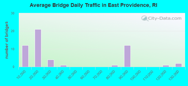
- 1,874,391Total average daily traffic
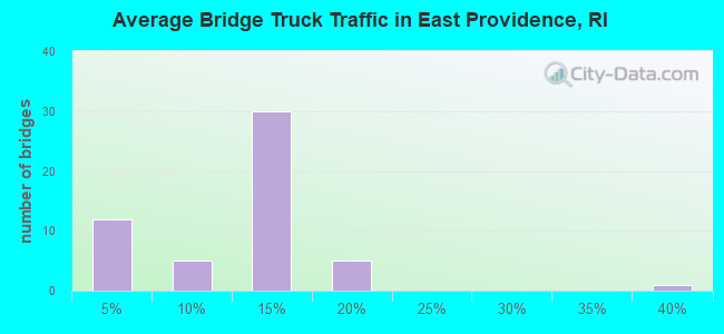
- 198,027Total average daily truck traffic
- National Bridge Inventory (NBI) Registered Bridges for East Providence
- No street view available for this location
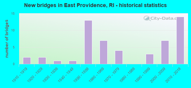
- New bridges - historical statistics
- 21910-1919
- 21920-1929
- 11930-1939
- 11940-1949
- 131950-1959
- 71960-1969
- 41970-1979
- 31990-1999
- 72000-2009
- 142010-2019
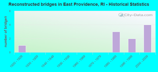
- Reconstructed bridges - Historical Statistics
- 11920-1929
- 01930-1939
- 01940-1949
- 01950-1959
- 01960-1969
- 01970-1979
- 31980-1989
- 21990-1999
- 42000-2009
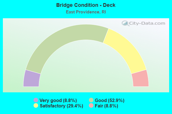
- Bridge Condition - Deck
- 8.8%Very good
- 52.9%Good
- 29.4%Satisfactory
- 8.8%Fair
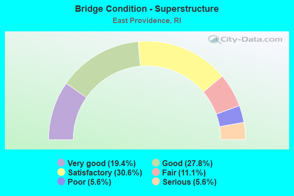
- Bridge Condition - Superstructure
- 19.4%Very good
- 27.8%Good
- 30.6%Satisfactory
- 11.1%Fair
- 5.6%Poor
- 5.6%Serious
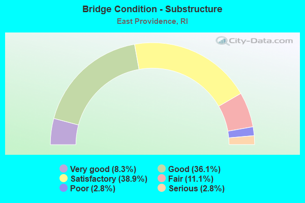
- Bridge Condition - Substructure
- 8.3%Very good
- 36.1%Good
- 38.9%Satisfactory
- 11.1%Fair
- 2.8%Poor
- 2.8%Serious
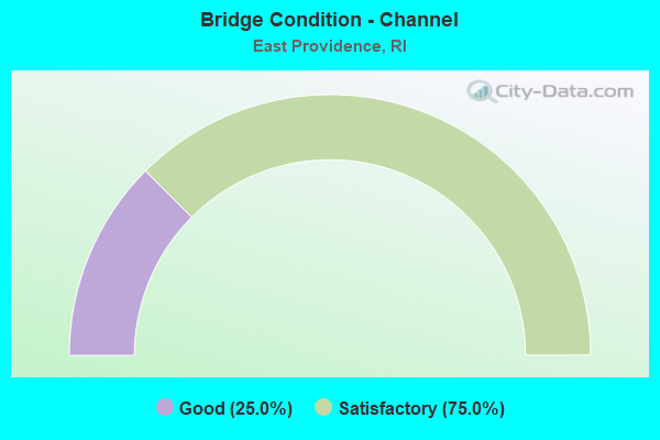
- Bridge Condition - Channel
- 25.0%Good
- 75.0%Satisfactory
Find on map >> Show street view
Structure Number: 946, Location: 0.1 Mi N of Waterfrt Dr (Lat: 41.826300, Lng: -71.378864), Route carried "on" structure: Spur City street , Year Built: 1994, Status: Posted for load, Structure Length: 1.52m (4.99ft), Average Daily Traffic: 200 (year 2008), Truck Traffic: 10%, Average Future Daily Traffic: 240 (year 2036), Design Load: H 15, Features Intersected: P&W RR R.O.W., Facility Carried by Structure: WATERMAN AV
Minimum Vertical Clearance: 30+ m (98+ ft), Kilometerpoint: 0.056, Lanes on structure: 2, Owner: State Highway Agency, Approaching Roadway Width: 7.3m (24.0ft), Material/Design: Prestressed concrete, Design/Construction: Box Beam or Girders - Multiple, Number Of Spans In Main Unit: 1, Length of Maximum Span: 14.6m (47.9ft), Curb or Sidewalk Widths: Left: 0.0m, Right: 1.5m (4.9ft), Curb-To-Curb Width: 7.3m (24.0ft), Out-to-Out Width: 9.8m (32.2ft)
Condition: Deck: Satisfactory, Superstructure: Satisfactory, Substructure: Good, Operating Rating: 30.1 metric tons, Method Used To Determine Operating Rating: Load and Resistance Factor Rating (LRFR) rating reported by rating factor(RF) method using HL-93 loadings, Inventory Rating: 22.0 metric tons, Method Used To Determine Inventory Rating: Load and Resistance Factor Rating (LRFR) rating reported by rating factor(RF) method using HL-93 loadings, Structural Evaluation: Equal to present minimum criteria, Deck Geometry: Somewhat better than minimum adequacy, Approach Roadway Alignment: Equal to present desirable criteria, Bridge Posting: Required (Relationship of Operating Rating to Maximum Legal Load: 10.0 - 19.9% below), Length Of Structure Improvement: 0.98m (3.22ft), Designated Inspection Frequency: Every 24 months, Other Special Inspection Frequency: Every 12 months, Inspection Date: October 2021, Other Special Inspection Date: October 2021, Bridge Improvement Cost: $1,339,000, Roadway Improvement Cost: $134,000, Total Project Cost: $2,009,000, Deck Structure Type: Other, Wearing Surface/Protective System: Wearing Surface: Bituminous
Find on map >> Show street view
Structure Number: 994, Location: 0.1 Mi N of No Broadway (Lat: 41.833664, Lng: -71.360669), Route carried "on" structure: City street , Year Built: 1946, Year Reconstructed: 1989, Status: Open, Structure Length: 2.65m (8.69ft), Average Daily Traffic: 10,151 (year 2014), Truck Traffic: 10%, Average Future Daily Traffic: 12,182 (year 2036), Design Load: HS 20, Features Intersected: TEN MILE RIVER, Facility Carried by Structure: ROGER WILLIAMS AV
Minimum Vertical Clearance: 30+ m (98+ ft), Kilometerpoint: 0.945, Lanes on structure: 2, Owner: State Highway Agency, Approaching Roadway Width: 9.1m (29.9ft), Material/Design: Prestressed concrete, Design/Construction: Box Beam or Girders - Multiple, Number Of Spans In Main Unit: 3, Length of Maximum Span: 10.7m (35.1ft), Curb or Sidewalk Widths: Left: 1.5m (4.9ft), Right: 1.5m (4.9ft), Curb-To-Curb Width: 9.1m (29.9ft), Out-to-Out Width: 12.9m (42.3ft)
Condition: Deck: Good, Superstructure: Satisfactory, Substructure: Satisfactory, Channel: Satisfactory, Operating Rating: 54.1 metric tons, Method Used To Determine Operating Rating: Load and Resistance Factor Rating (LRFR) rating reported by rating factor(RF) method using HL-93 loadings, Inventory Rating: 41.8 metric tons, Method Used To Determine Inventory Rating: Load and Resistance Factor Rating (LRFR) rating reported by rating factor(RF) method using HL-93 loadings, Structural Evaluation: Equal to present minimum criteria, Deck Geometry: High priority of corrective action, Waterway Adequacy: Better than present minimum criteria, Approach Roadway Alignment: Equal to present minimum criteria, Length Of Structure Improvement: 2.65m (8.69ft), Designated Inspection Frequency: Every 24 months, Underwater Inspection Frequency: Every 48 months, Inspection Date: June 2021, Underwater Inspection Date: June 2021, Bridge Improvement Cost: $241,000, Roadway Improvement Cost: $24,000, Total Project Cost: $362,000
Find on map >> Show street view
Structure Number: 1092, Location: 0.4 mi W of RI 103 (Lat: 41.758822, Lng: -71.353742), Route carried "on" structure: City street , Year Built: 2007, Status: Open, Structure Length: 1.23m (4.04ft), Average Daily Traffic: 5,600 (year 2021), Truck Traffic: 12%, Average Future Daily Traffic: 6,160 (year 2041), Design Load: H 20, Features Intersected: Bullock Cove, Facility Carried by Structure: Crescent View Av
Minimum Vertical Clearance: 30+ m (98+ ft), Kilometerpoint: 0.525, Lanes on structure: 2, Owner: City or Municipal Highway Agency, Approaching Roadway Width: 13.3m (43.6ft), Material/Design: Aluminum, Iron, Design/Construction: Culvert, Number Of Spans In Main Unit: 2, Length of Maximum Span: 4.3m (14.1ft), Curb or Sidewalk Widths: Left: 1.9m (6.2ft), Right: 2.0m (6.6ft), Out-to-Out Width: 13.3m (43.6ft)
Condition: Channel: Good, Culverts: Good, Operating Rating: 97.2 metric tons, Method Used To Determine Operating Rating: Load and Resistance Factor Rating (LRFR) rating reported by rating factor(RF) method using HL-93 loadings, Inventory Rating: 97.2 metric tons, Method Used To Determine Inventory Rating: Load and Resistance Factor Rating (LRFR) rating reported by rating factor(RF) method using HL-93 loadings, Structural Evaluation: Better than present minimum criteria, Waterway Adequacy: Better than present minimum criteria, Approach Roadway Alignment: Better than present minimum criteria, Designated Inspection Frequency: Every 24 months, Inspection Date: November 2020
Find on map >> Show street view
Structure Number: 463, Location: 1.4 Mi W of JCT RI 114 (Lat: 41.818608, Lng: -71.381433), Route carried "under" structure: Interstate 195, Year Built: 2005, Structure Length: 0. m, Average Daily Traffic: 82,500 (year 2008), Truck Traffic: 10%, Features Intersected: I-195 EB & WB, Facility Carried by Structure: TAUNTON AV RAMP
Minimum Vertical Clearance: 8.11m (26.61ft), Kilometerpoint: 0.000, Lanes on structure: 1, Lanes under structure: 7, Material/Design: Steel continuous, Design/Construction: Stringer/Multi-beam, Length of Maximum Span: 53.6m (175.9ft)
Find on map >> Show street view
Structure Number: 464, Location: 400ft S.of Jct RI 403 (Lat: 41.817675, Lng: -71.382333), Route carried "under" structure: US 6, Year Built: 2013, Structure Length: 0. m, Average Daily Traffic: 16,300 (year 2008), Truck Traffic: 10%, Features Intersected: US 6 WARREN AV, Facility Carried by Structure: I-195 RAMP CR-3
Minimum Vertical Clearance: 5.00m (16.40ft), Kilometerpoint: 0.000, Lanes on structure: 1, Lanes under structure: 2, Material/Design: Steel continuous, Design/Construction: Stringer/Multi-beam, Length of Maximum Span: 17.1m (56.1ft)
Find on map >> Show street view
Structure Number: 465, Location: 0.1 Mi E of SEEKONK RVR (Lat: 41.817567, Lng: -71.382053), Route carried "under" structure: US 6, Year Built: 1959, Structure Length: 0. m, Average Daily Traffic: 18,950 (year 1992), Truck Traffic: 10%, Features Intersected: US 6 WARREN AV, Facility Carried by Structure: I-195 RAMP DR-2
Minimum Vertical Clearance: 4.52m (14.83ft), Kilometerpoint: 0.000, Lanes on structure: 1, Lanes under structure: 2, Material/Design: Steel, Design/Construction: Stringer/Multi-beam, Length of Maximum Span: 25.6m (84.0ft)
Find on map >> Show street view
Structure Number: 4665, Location: 0.5 Mi W of JCT RI 114 (Lat: 41.818408, Lng: -71.380972), Route carried "under" structure: Interstate 195, Year Built: 2018, Structure Length: 0. m, Average Daily Traffic: 16,300 (year 2008), Truck Traffic: 10%, Features Intersected: I-195 EB & WB, Facility Carried by Structure: US 6 WRRN AV & RMP
Minimum Vertical Clearance: 5.69m (18.67ft), Kilometerpoint: 0.000, Lanes on structure: 1, Lanes under structure: 7, Material/Design: Steel continuous, Design/Construction: Stringer/Multi-beam, Length of Maximum Span: 24.4m (80.1ft)
Find on map >> Show street view
Structure Number: 467, Location: 0.1 Mi S of JCT US 44 (Lat: 41.818139, Lng: -71.380292), Route carried "under" structure: Interstate 195, Year Built: 1959, Structure Length: 0. m, Average Daily Traffic: 82,500 (year 2008), Truck Traffic: 10%, Features Intersected: I-195 EB & WB, Facility Carried by Structure: POTTER ST
Minimum Vertical Clearance: 6.68m (21.92ft), Kilometerpoint: 0.000, Lanes on structure: 2, Lanes under structure: 6, Material/Design: Concrete continuous, Design/Construction: Frame, Length of Maximum Span: 17.7m (58.1ft)
Find on map >> Show street view
Structure Number: 468, Location: 0.2 Mi S of JCT US 44 (Lat: 41.817392, Lng: -71.378375), Route carried "under" structure: Interstate 195, Year Built: 1959, Structure Length: 0. m, Average Daily Traffic: 82,500 (year 2008), Truck Traffic: 10%, Features Intersected: I-195 EB & WB, Facility Carried by Structure: PURCHASE ST
Minimum Vertical Clearance: 5.16m (16.93ft), Kilometerpoint: 0.000, Lanes on structure: 2, Lanes under structure: 6, Material/Design: Concrete continuous, Design/Construction: Frame, Length of Maximum Span: 17.7m (58.1ft)
Find on map >> Show street view
Structure Number: 469, Location: 0.9 Mi N of JCT Vet Mem P (Lat: 41.816244, Lng: -71.375053), Route carried "under" structure: Interstate 195, Year Built: 1959, Structure Length: 0. m, Average Daily Traffic: 82,500 (year 2008), Truck Traffic: 10%, Features Intersected: I-195 EB & WB, Facility Carried by Structure: LYON AV
Minimum Vertical Clearance: 4.95m (16.24ft), Kilometerpoint: 0.000, Lanes on structure: 2, Lanes under structure: 6, Material/Design: Concrete continuous, Design/Construction: Frame, Length of Maximum Span: 17.7m (58.1ft)
Find on map >> Show street view
Structure Number: 4715, Location: 0.7 Mi S of JCT US 44 (Lat: 41.812250, Lng: -71.358450), Route carried "under" structure: Interstate 195, Year Built: 2017, Structure Length: 0. m, Average Daily Traffic: 115,300 (year 2001), Features Intersected: I-195EB & WB, Facility Carried by Structure: RI 114 PAWTUCKT AV
Minimum Vertical Clearance: 5.51m (18.08ft), Kilometerpoint: 0.000, Lanes on structure: 4, Lanes under structure: 8, Material/Design: Steel, Design/Construction: Stringer/Multi-beam, Length of Maximum Span: 21.7m (71.2ft)
Find on map >> Show street view
Structure Number: 4725, Location: 0.7 Mi W of MASS LINE (Lat: 41.810800, Lng: -71.351461), Route carried "under" structure: Interstate 195, Year Built: 2019, Structure Length: 0. m, Average Daily Traffic: 121,000 (year 2008), Truck Traffic: 10%, Features Intersected: I-195 EB & WB, Facility Carried by Structure: RI 114 LANE F
Minimum Vertical Clearance: 7.32m (24.02ft), Kilometerpoint: 0.000, Lanes on structure: 3, Lanes under structure: 6, Material/Design: Steel continuous, Design/Construction: Stringer/Multi-beam, Length of Maximum Span: 42.1m (138.1ft)
Find on map >> Show street view
Structure Number: 473, Location: 0.1 Mi W of MASS LINE (Lat: 41.807881, Lng: -71.341675), Route carried "under" structure: US 6, Year Built: 2005, Structure Length: 0. m, Average Daily Traffic: 86,400 (year 2021), Truck Traffic: 14%, Features Intersected: US 6 WARREN AV, Facility Carried by Structure: I-195 EB & WB
Minimum Vertical Clearance: 4.55m (14.93ft), Kilometerpoint: 0.000, Lanes on structure: 6, Lanes under structure: 3, Material/Design: Prestressed concrete continuous, Design/Construction: Stringer/Multi-beam, Length of Maximum Span: 18.9m (62.0ft)
Find on map >> Show street view
Structure Number: 4755, Location: 1.1 Mi N of JCT RI 114 (Lat: 41.810000, Lng: -71.353889), Route carried "under" structure: Alternate US 6, Year Built: 2016, Structure Length: 0. m, Average Daily Traffic: 18,700 (year 2015), Truck Traffic: 3%, Features Intersected: US 6 WARREN AV, Facility Carried by Structure: I-195 LANE E
Minimum Vertical Clearance: 5.84m (19.16ft), Kilometerpoint: 0.000, Lanes on structure: 2, Lanes under structure: 4, Material/Design: Steel, Design/Construction: Stringer/Multi-beam, Length of Maximum Span: 45.3m (148.6ft)
Find on map >> Show street view
Structure Number: 477, Location: 1.0 Mi S of JCT I-195 (Lat: 41.795406, Lng: -71.351372), Route carried "under" structure: State highway 114, Year Built: 1959, Structure Length: 0. m, Average Daily Traffic: 10,100 (year 2021), Truck Traffic: 7%, Features Intersected: RI 114 EAST SHORE EXPWY, Facility Carried by Structure: WAMPANOAG TRAIL
Minimum Vertical Clearance: 4.64m (15.22ft), Kilometerpoint: 0.000, Lanes on structure: 2, Lanes under structure: 4, Material/Design: Steel continuous, Design/Construction: Stringer/Multi-beam, Length of Maximum Span: 15.9m (52.2ft)
Find on map >> Show street view
Structure Number: 597, Location: 0.5 Mi W of JCT RI 114 (Lat: 41.825850, Lng: -71.365183), Route carried "under" structure: Ramp Interstate 195, Year Built: 1971, Structure Length: 0. m, Average Daily Traffic: 76,000 (year 2008), Truck Traffic: 10%, Features Intersected: RAMP (SEEKONK RVR CRSS), Facility Carried by Structure: NORTH BROADWAY
Minimum Vertical Clearance: 4.64m (15.22ft), Kilometerpoint: 0.000, Lanes on structure: 4, Lanes under structure: 3, Material/Design: Steel, Design/Construction: Stringer/Multi-beam, Length of Maximum Span: 22.3m (73.2ft)
Find on map >> Show street view
Structure Number: 7, Location: 0.2 Mi W of JCT US 6 (Lat: 41.819267, Lng: -71.386550), Route carried "under" structure: City street , Year Built: 1969, Structure Length: 0. m, Average Daily Traffic: 80,500 (year 2021), Truck Traffic: 19%, Features Intersected: SEEKONK RIVER, Facility Carried by Structure: I-195 WB
Minimum Vertical Clearance: 4.52m (14.83ft), Kilometerpoint: 0.000, Lanes on structure: 5, Lanes under structure: 2, Material/Design: Steel, Design/Construction: Stringer/Multi-beam, Length of Maximum Span: 39.8m (130.6ft)
Find on map >> Show street view
Structure Number: 7, Location: 0.2 Mi W of JCT US 6 (Lat: 41.819267, Lng: -71.386550), Route carried "under" structure: Alternate City street , Year Built: 1969, Structure Length: 0. m, Average Daily Traffic: 80,500 (year 2021), Truck Traffic: 19%, Features Intersected: SEEKONK RIVER, Facility Carried by Structure: I-195 WB
Minimum Vertical Clearance: 7.62m (25.00ft), Kilometerpoint: 0.000, Lanes on structure: 5, Lanes under structure: 2, Material/Design: Steel, Design/Construction: Stringer/Multi-beam, Length of Maximum Span: 39.8m (130.6ft)
Find on map >> Show street view
Structure Number: 7, Location: 0.2 Mi W of JCT US 6 (Lat: 41.819267, Lng: -71.386550), Route carried "under" structure: Alternate City street , Year Built: 1969, Structure Length: 0. m, Average Daily Traffic: 80,500 (year 2021), Truck Traffic: 19%, Features Intersected: SEEKONK RIVER, Facility Carried by Structure: I-195 WB
Minimum Vertical Clearance: 6.40m (21.00ft), Kilometerpoint: 0.000, Lanes on structure: 5, Lanes under structure: 2, Material/Design: Steel, Design/Construction: Stringer/Multi-beam, Length of Maximum Span: 39.8m (130.6ft)
Find on map >> Show street view
Structure Number: 7, Location: 0.2 Mi W of JCT US 6 (Lat: 41.819267, Lng: -71.386550), Route carried "under" structure: Alternate City street , Year Built: 1969, Structure Length: 0. m, Average Daily Traffic: 80,500 (year 2021), Truck Traffic: 19%, Features Intersected: SEEKONK RIVER, Facility Carried by Structure: I-195 WB
Minimum Vertical Clearance: 4.33m (14.21ft), Kilometerpoint: 0.000, Lanes on structure: 5, Lanes under structure: 2, Material/Design: Steel, Design/Construction: Stringer/Multi-beam, Length of Maximum Span: 39.8m (130.6ft)