Bridge Statistics for Edina, Minnesota (MN)
Condition, Traffic, Stress, Structural Evaluation, Project Costs
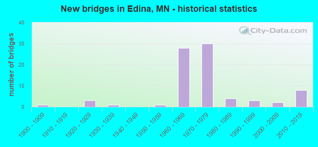
- New bridges - historical statistics
- 11900-1909
- 31920-1929
- 11930-1939
- 11950-1959
- 281960-1969
- 301970-1979
- 41980-1989
- 31990-1999
- 22000-2009
- 82010-2019
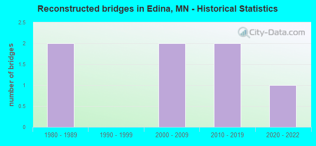
- Reconstructed bridges - Historical Statistics
- 21980-1989
- 01990-1999
- 22000-2009
- 22010-2019
- 12020-2022
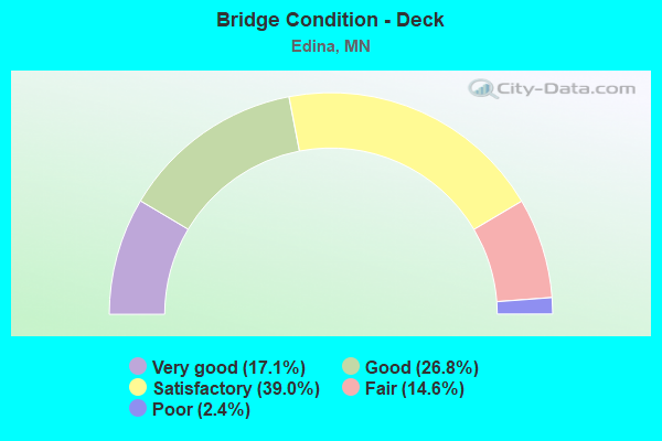
- Bridge Condition - Deck
- 17.1%Very good
- 26.8%Good
- 39.0%Satisfactory
- 14.6%Fair
- 2.4%Poor
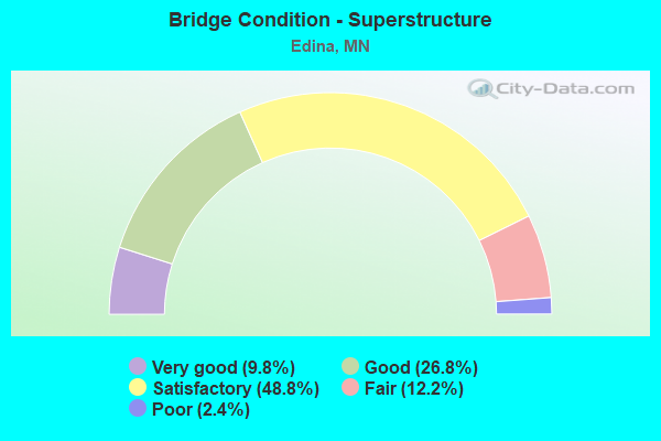
- Bridge Condition - Superstructure
- 9.8%Very good
- 26.8%Good
- 48.8%Satisfactory
- 12.2%Fair
- 2.4%Poor
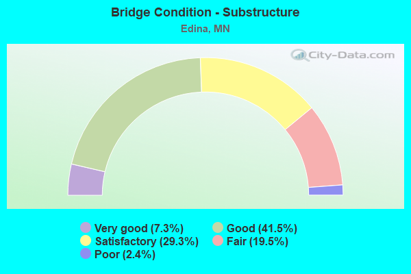
- Bridge Condition - Substructure
- 7.3%Very good
- 41.5%Good
- 29.3%Satisfactory
- 19.5%Fair
- 2.4%Poor
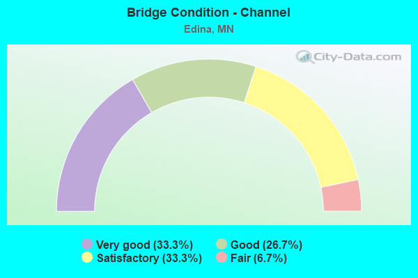
- Bridge Condition - Channel
- 33.3%Very good
- 26.7%Good
- 33.3%Satisfactory
- 6.7%Fair
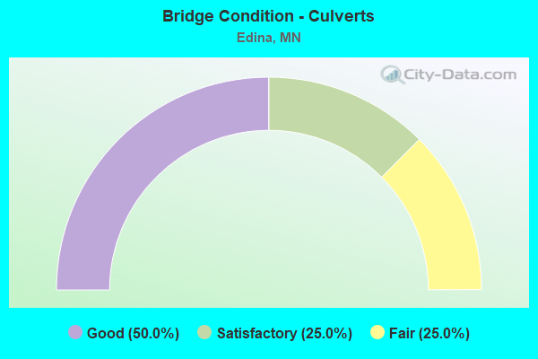
- Bridge Condition - Culverts
- 50.0%Good
- 25.0%Satisfactory
- 25.0%Fair
Find on map >> Show street view
Structure Number: 9895, Location: 0.7 MI N OF JCT TH 62 (Lat: 44.899986, Lng: -93.349914), Route carried "on" structure: , Year Built: 1971, Status: Open, Structure Length: 22.19m (72.80ft), Features Intersected: TH 100, Frontage Roads, Facility Carried by Structure: PEDESTRIAN
Lanes under structure: 30, Owner: State Highway Agency, Material/Design: Steel continuous, Design/Construction: Stringer/Multi-beam, Number Of Spans In Main Unit: 3, Number Of Approach Spans: 21, Length of Maximum Span: 43.3m (142.1ft), Out-to-Out Width: 2.9m (9.5ft)
Condition: Deck: Satisfactory, Superstructure: Satisfactory, Substructure: Good, Underclear: Better than present minimum criteria, Bridge Posting: Required (Relationship of Operating Rating to Maximum Legal Load: > 39.9% below), Designated Inspection Frequency: Every 24 months, Inspection Date: May 2021, Deck Structure Type: Concrete Cast-file-Place
Find on map >> Show street view
Structure Number: 9896, Location: 1.1 MI N OF JCT TH 62 (Lat: 44.903911, Lng: -93.349906), Route carried "on" structure: , Year Built: 1971, Status: Open, Structure Length: 18.98m (62.27ft), Features Intersected: TH 100, Frontage Roads, Facility Carried by Structure: PEDESTRIAN
Lanes under structure: 30, Owner: State Highway Agency, Material/Design: Steel continuous, Design/Construction: Stringer/Multi-beam, Number Of Spans In Main Unit: 3, Number Of Approach Spans: 16, Length of Maximum Span: 43.3m (142.1ft), Out-to-Out Width: 2.9m (9.5ft)
Condition: Deck: Satisfactory, Superstructure: Satisfactory, Substructure: Satisfactory, Underclear: Better than present minimum criteria, Bridge Posting: Required (Relationship of Operating Rating to Maximum Legal Load: > 39.9% below), Designated Inspection Frequency: Every 24 months, Inspection Date: May 2021, Deck Structure Type: Concrete Cast-file-Place
Find on map >> Show street view
Structure Number: L4368, Location: 0.6 MI N OF JCT 77TH ST (Lat: 44.871236, Lng: -93.351106), Route carried "on" structure: City street 172, Year Built: 1975, Status: Open, Structure Length: 1.22m (4.00ft), Average Daily Traffic: 5,900 (year 2015), Average Future Daily Traffic: 5,900 (year 2039), Design Load: HS 20, Features Intersected: N BRANCH NINE MILE CRK
Minimum Vertical Clearance: 30+ m (98+ ft), Kilometerpoint: 0.000, Lanes on structure: 2, Owner: City or Municipal Highway Agency, Approaching Roadway Width: 15.9m (52.2ft), Skew: 4 degrees, Material/Design: Concrete, Design/Construction: Culvert, Number Of Spans In Main Unit: 2, Length of Maximum Span: 5.7m (18.7ft)
Condition: Channel: Good, Culverts: Good, Operating Rating: 36.6 metric tons, Method Used To Determine Operating Rating: Assigned ratings based on Allowable Stress Design (ASD) reported in metric tons, Inventory Rating: 29.4 metric tons, Method Used To Determine Inventory Rating: Assigned ratings based on Allowable Stress Design (ASD) reported in metric tons, Structural Evaluation: Better than present minimum criteria, Waterway Adequacy: Equal to present desirable criteria, Approach Roadway Alignment: Equal to present desirable criteria, Designated Inspection Frequency: Every 24 months, Inspection Date: October 2021
Find on map >> Show street view
Structure Number: L5961, Location: 0.1 MI E OF JCT CSAH 158 (Lat: 44.911811, Lng: -93.353583), Route carried "on" structure: City street 836, Year Built: 1967, Status: Open, Structure Length: 2.97m (9.74ft), Average Daily Traffic: 3,900 (year 2013), Average Future Daily Traffic: 3,900 (year 2039), Design Load: HS 20, Features Intersected: CP RAIL
Minimum Vertical Clearance: 30+ m (98+ ft), Kilometerpoint: 0.000, Lanes on structure: 2, Owner: City or Municipal Highway Agency, Approaching Roadway Width: 7.3m (24.0ft), Material/Design: Prestressed concrete, Design/Construction: Slab, Number Of Spans In Main Unit: 3, Length of Maximum Span: 9.6m (31.5ft), Curb or Sidewalk Widths: Left: 1.7m (5.6ft), Right: 0.0m, Curb-To-Curb Width: 7.3m (24.0ft), Out-to-Out Width: 8.2m (26.9ft)
Condition: Deck: Good, Superstructure: Good, Substructure: Good, Operating Rating: 67.9 metric tons, Method Used To Determine Operating Rating: Load Factor (LF), Inventory Rating: 42.4 metric tons, Method Used To Determine Inventory Rating: Load Factor (LF), Structural Evaluation: Better than present minimum criteria, Deck Geometry: High priority of replacement, Underclear: Meets minimum limits, Approach Roadway Alignment: Somewhat better than minimum adequacy, Designated Inspection Frequency: Every 24 months, Inspection Date: October 2021, Deck Structure Type: Concrete Cast-file-Place, Wearing Surface/Protective System: Wearing Surface: Bituminous, Membrane: Preformed Fabric
Find on map >> Show street view
Structure Number: 27029, Location: 2.3 MI S OF JCT TH 7 (Lat: 44.910328, Lng: -93.350717), Route carried "under" structure: State highway 100, Year Built: 1970, Structure Length: 0. m, Average Daily Traffic: 124,000 (year 2019), Truck Traffic: 3%, Features Intersected: TH 100; RAMPS, Facility Carried by Structure: MSAS 163
Minimum Vertical Clearance: 6.16m (20.21ft), Kilometerpoint: 0.000, Lanes on structure: 2, Lanes under structure: 4, Material/Design: Steel continuous, Design/Construction: Stringer/Multi-beam, Length of Maximum Span: 31.9m (104.7ft)
Find on map >> Show street view
Structure Number: 27029, Location: 2.3 MI S OF JCT TH 7 (Lat: 44.910328, Lng: -93.350717), Route carried "under" structure: Ramp State highway 3477, Year Built: 1970, Structure Length: 0. m, Average Daily Traffic: 8,200 (year 1994), Features Intersected: TH 100; RAMPS, Facility Carried by Structure: MSAS 163
Minimum Vertical Clearance: 6.37m (20.90ft), Kilometerpoint: 0.000, Lanes on structure: 2, Lanes under structure: 1, Material/Design: Steel continuous, Design/Construction: Stringer/Multi-beam, Length of Maximum Span: 31.9m (104.7ft)
Find on map >> Show street view
Structure Number: 27029, Location: 2.3 MI S OF JCT TH 7 (Lat: 44.910328, Lng: -93.350717), Route carried "under" structure: Ramp State highway 3312, Year Built: 1970, Structure Length: 0. m, Average Daily Traffic: 8,700 (year 1994), Features Intersected: TH 100; RAMPS, Facility Carried by Structure: MSAS 163
Minimum Vertical Clearance: 4.91m (16.11ft), Kilometerpoint: 0.000, Lanes on structure: 2, Lanes under structure: 1, Material/Design: Steel continuous, Design/Construction: Stringer/Multi-beam, Length of Maximum Span: 31.9m (104.7ft)
Find on map >> Show street view
Structure Number: 27079, Location: AT JCT OF TH 169,212; 62 (Lat: 44.890656, Lng: -93.399536), Route carried "under" structure: State highway 62, Year Built: 1968, Structure Length: 0. m, Average Daily Traffic: 26,000 (year 2019), Truck Traffic: 3%, Features Intersected: US 212; TH 62, Facility Carried by Structure: US 169
Minimum Vertical Clearance: 4.79m (15.72ft), Kilometerpoint: 0.000, Lanes on structure: 3, Lanes under structure: 3, Material/Design: Steel continuous, Design/Construction: Stringer/Multi-beam, Length of Maximum Span: 33.2m (108.9ft)
Find on map >> Show street view
Structure Number: 27079, Location: AT JCT OF TH 169,212; 62 (Lat: 44.890656, Lng: -93.399536), Route carried "under" structure: State highway 62, Year Built: 1968, Structure Length: 0. m, Average Daily Traffic: 28,500 (year 2004), Truck Traffic: 2%, Features Intersected: US 212; TH 62, Facility Carried by Structure: US 169
Minimum Vertical Clearance: 4.63m (15.19ft), Kilometerpoint: 0.000, Lanes on structure: 3, Lanes under structure: 3, Material/Design: Steel continuous, Design/Construction: Stringer/Multi-beam, Length of Maximum Span: 33.2m (108.9ft)
Find on map >> Show street view
Structure Number: 27079, Location: AT JCT OF TH 169,212; 62 (Lat: 44.890656, Lng: -93.399536), Route carried "under" structure: US 212, Year Built: 1968, Structure Length: 0. m, Average Daily Traffic: 33,500 (year 2019), Truck Traffic: 3%, Features Intersected: US 212; TH 62, Facility Carried by Structure: US 169
Minimum Vertical Clearance: 4.88m (16.01ft), Kilometerpoint: 0.000, Lanes on structure: 3, Lanes under structure: 4, Material/Design: Steel continuous, Design/Construction: Stringer/Multi-beam, Length of Maximum Span: 33.2m (108.9ft)
Find on map >> Show street view
Structure Number: 2708, Location: AT JCT OF TH 169,212; 62 (Lat: 44.890736, Lng: -93.399292), Route carried "under" structure: State highway 62, Year Built: 1968, Structure Length: 0. m, Average Daily Traffic: 28,500 (year 2004), Truck Traffic: 2%, Features Intersected: US 212; TH 62, Facility Carried by Structure: US 169
Minimum Vertical Clearance: 5.24m (17.19ft), Kilometerpoint: 0.000, Lanes on structure: 3, Lanes under structure: 3, Material/Design: Steel continuous, Design/Construction: Stringer/Multi-beam, Length of Maximum Span: 33.2m (108.9ft)
Find on map >> Show street view
Structure Number: 2708, Location: AT JCT OF TH 169,212; 62 (Lat: 44.890736, Lng: -93.399292), Route carried "under" structure: State highway 62, Year Built: 1968, Structure Length: 0. m, Average Daily Traffic: 26,000 (year 2019), Truck Traffic: 3%, Features Intersected: US 212; TH 62, Facility Carried by Structure: US 169
Minimum Vertical Clearance: 5.55m (18.21ft), Kilometerpoint: 0.000, Lanes on structure: 3, Lanes under structure: 3, Material/Design: Steel continuous, Design/Construction: Stringer/Multi-beam, Length of Maximum Span: 33.2m (108.9ft)
Find on map >> Show street view
Structure Number: 2708, Location: AT JCT OF TH 169,212; 62 (Lat: 44.890736, Lng: -93.399292), Route carried "under" structure: US 212, Year Built: 1968, Structure Length: 0. m, Average Daily Traffic: 33,500 (year 2019), Truck Traffic: 3%, Features Intersected: US 212; TH 62, Facility Carried by Structure: US 169
Minimum Vertical Clearance: 5.46m (17.91ft), Kilometerpoint: 0.000, Lanes on structure: 3, Lanes under structure: 4, Material/Design: Steel continuous, Design/Construction: Stringer/Multi-beam, Length of Maximum Span: 33.2m (108.9ft)
Find on map >> Show street view
Structure Number: 27082, Location: 1.7 MI W OF JCT TH 100 (Lat: 44.889594, Lng: -93.386978), Route carried "under" structure: State highway 62, Year Built: 1966, Structure Length: 0. m, Average Daily Traffic: 84,000 (year 2019), Truck Traffic: 3%, Features Intersected: TH 62, Facility Carried by Structure: CSAH 158
Minimum Vertical Clearance: 4.76m (15.62ft), Kilometerpoint: 0.000, Lanes on structure: 2, Lanes under structure: 6, Material/Design: Prestressed concrete, Design/Construction: Stringer/Multi-beam, Length of Maximum Span: 17.4m (57.1ft)
Find on map >> Show street view
Structure Number: 27083, Location: 0.8 MI W OF JCT TH 100 (Lat: 44.887475, Lng: -93.368989), Route carried "under" structure: State highway 62, Year Built: 1965, Structure Length: 0. m, Average Daily Traffic: 80,000 (year 2019), Truck Traffic: 3%, Features Intersected: TH 62, Facility Carried by Structure: MSAS 152
Minimum Vertical Clearance: 5.52m (18.11ft), Kilometerpoint: 0.000, Lanes on structure: 4, Lanes under structure: 4, Material/Design: Prestressed concrete, Design/Construction: Stringer/Multi-beam, Length of Maximum Span: 22.9m (75.1ft)
Find on map >> Show street view
Structure Number: 27084, Location: 0.4 MI W OF JCT TH 100 (Lat: 44.889636, Lng: -93.358489), Route carried "under" structure: State highway 62, Year Built: 1965, Structure Length: 0. m, Average Daily Traffic: 80,000 (year 2019), Truck Traffic: 3%, Features Intersected: TH 62, Facility Carried by Structure: MUN 264
Minimum Vertical Clearance: 5.15m (16.90ft), Kilometerpoint: 0.000, Lanes on structure: 2, Lanes under structure: 4, Material/Design: Prestressed concrete, Design/Construction: Stringer/Multi-beam, Length of Maximum Span: 17.4m (57.1ft)
Find on map >> Show street view
Structure Number: 27102, Location: 2.2 MI S OF JCT TH 7 (Lat: 44.912453, Lng: -93.350747), Route carried "under" structure: State highway 100, Year Built: 1970, Structure Length: 0. m, Average Daily Traffic: 124,000 (year 2019), Truck Traffic: 3%, Features Intersected: TH 100, Facility Carried by Structure: CSAH 158
Minimum Vertical Clearance: 5.27m (17.29ft), Kilometerpoint: 0.000, Lanes on structure: 4, Lanes under structure: 7, Material/Design: Steel continuous, Design/Construction: Stringer/Multi-beam, Length of Maximum Span: 29.0m (95.1ft)
Find on map >> Show street view
Structure Number: 27104, Location: 1.7 MI S OF JCT TH 7 (Lat: 44.918775, Lng: -93.349769), Route carried "under" structure: City street 140, Year Built: 1970, Structure Length: 0. m, Average Daily Traffic: 3,700 (year 2005), Features Intersected: 44th St, Facility Carried by Structure: MN 100
Minimum Vertical Clearance: 4.79m (15.72ft), Kilometerpoint: 0.000, Lanes on structure: 6, Lanes under structure: 2, Material/Design: Steel continuous, Design/Construction: Stringer/Multi-beam, Length of Maximum Span: 14.9m (48.9ft)
Find on map >> Show street view
Structure Number: 2721, Location: 0.2 MI N OF JCT TH 494 (Lat: 44.864197, Lng: -93.350097), Route carried "under" structure: State highway 100, Year Built: 1974, Structure Length: 0. m, Average Daily Traffic: 78,000 (year 2019), Truck Traffic: 3%, Features Intersected: TH 100, Facility Carried by Structure: MSAS 136
Minimum Vertical Clearance: 5.00m (16.40ft), Kilometerpoint: 0.000, Lanes on structure: 5, Lanes under structure: 7, Material/Design: Steel continuous, Design/Construction: Stringer/Multi-beam, Length of Maximum Span: 27.5m (90.2ft)
Find on map >> Show street view
Structure Number: 2752, Location: 0.5 MI E OF JCT TH 100 (Lat: 44.886956, Lng: -93.338919), Route carried "under" structure: State highway 62, Year Built: 1963, Structure Length: 0. m, Average Daily Traffic: 83,000 (year 2019), Truck Traffic: 3%, Features Intersected: TH 62; W 64TH ST, Facility Carried by Structure: PEDESTRIAN
Minimum Vertical Clearance: 4.88m (16.01ft), Kilometerpoint: 0.000, Lanes on structure: 4, Lanes under structure: 6, Material/Design: Steel continuous, Design/Construction: Stringer/Multi-beam, Length of Maximum Span: 18.6m (61.0ft)
Find on map >> Show street view
Structure Number: 2752, Location: 0.5 MI E OF JCT TH 100 (Lat: 44.886956, Lng: -93.338919), Route carried "under" structure: City street 345, Year Built: 1963, Structure Length: 0. m, Average Daily Traffic: 130 (year 1985), Features Intersected: TH 62; W 64TH ST, Facility Carried by Structure: PEDESTRIAN
Minimum Vertical Clearance: 4.51m (14.80ft), Kilometerpoint: 0.000, Lanes on structure: 2, Lanes under structure: 6, Material/Design: Steel continuous, Design/Construction: Stringer/Multi-beam, Length of Maximum Span: 18.6m (61.0ft)
Find on map >> Show street view
Structure Number: 27567, Location: 1.7 MI N OF JCT TH 62 (Lat: 44.913503, Lng: -93.401200), Route carried "under" structure: US 169, Year Built: 1976, Structure Length: 0. m, Average Daily Traffic: 88,000 (year 2019), Truck Traffic: 7%, Features Intersected: US 169, Facility Carried by Structure: MUN 849
Minimum Vertical Clearance: 4.66m (15.29ft), Kilometerpoint: 0.000, Lanes on structure: 4, Lanes under structure: 4, Material/Design: Prestressed concrete, Design/Construction: Stringer/Multi-beam, Length of Maximum Span: 26.2m (86.0ft)
Find on map >> Show street view
Structure Number: 27589, Location: 1.1 MI S OF JCT TH 62 (Lat: 44.873183, Lng: -93.396683), Route carried "under" structure: US 169, Year Built: 1976, Structure Length: 0. m, Average Daily Traffic: 63,000 (year 2019), Truck Traffic: 7%, Features Intersected: US 169, Facility Carried by Structure: MSAS 175
Minimum Vertical Clearance: 5.00m (16.40ft), Kilometerpoint: 0.000, Lanes on structure: 4, Lanes under structure: 4, Material/Design: Prestressed concrete, Design/Construction: Stringer/Multi-beam, Length of Maximum Span: 29.0m (95.1ft)
Find on map >> Show street view
Structure Number: 27B69, Location: 0.7 MI N OF JCT TH 62 (Lat: 44.898942, Lng: -93.401506), Route carried "under" structure: US 169, Year Built: 2011, Structure Length: 0. m, Average Daily Traffic: 86,000 (year 2019), Truck Traffic: 7%, Features Intersected: US 169, Facility Carried by Structure: MUN 850
Minimum Vertical Clearance: 6.61m (21.69ft), Kilometerpoint: 0.000, Lanes under structure: 4, Material/Design: Prestressed concrete, Design/Construction: Stringer/Multi-beam, Length of Maximum Span: 31.4m (103.0ft)
Find on map >> Show street view
Structure Number: 27W3, Location: 1.7 MI W OF JCT TH 100 (Lat: 44.889075, Lng: -93.382119), Route carried "under" structure: State highway 62, Year Built: 2016, Structure Length: 0. m, Average Daily Traffic: 84,000 (year 2019), Truck Traffic: 3%, Features Intersected: TH 62; CREEK, Facility Carried by Structure: PEDESTRIAN
Minimum Vertical Clearance: 5.40m (17.72ft), Kilometerpoint: 0.000, Lanes under structure: 5, Material/Design: Prestressed concrete, Design/Construction: Stringer/Multi-beam, Length of Maximum Span: 30.5m (100.1ft)
Find on map >> Show street view
Structure Number: 27W31, Location: 0.7 MI N OF JCT TH 62 (Lat: 44.871461, Lng: -93.350364), Route carried "under" structure: State highway 100, Year Built: 2016, Structure Length: 0. m, Average Daily Traffic: 73,000 (year 2019), Truck Traffic: 3%, Features Intersected: TH 100, Facility Carried by Structure: PEDESTRIAN
Minimum Vertical Clearance: 5.36m (17.59ft), Kilometerpoint: 0.000, Lanes under structure: 6, Material/Design: Prestressed concrete, Design/Construction: Stringer/Multi-beam, Length of Maximum Span: 41.1m (134.8ft)
Find on map >> Show street view
Structure Number: 27W31, Location: 0.7 MI N OF JCT TH 62 (Lat: 44.871461, Lng: -93.350364), Route carried "under" structure: City street 172, Year Built: 2016, Structure Length: 0. m, Average Daily Traffic: 5,500 (year 2009), Features Intersected: TH 100, Facility Carried by Structure: PEDESTRIAN
Minimum Vertical Clearance: 5.33m (17.49ft), Kilometerpoint: 0.000, Lanes under structure: 4, Material/Design: Prestressed concrete, Design/Construction: Stringer/Multi-beam, Length of Maximum Span: 41.1m (134.8ft)
Find on map >> Show street view
Structure Number: 7263, Location: 1.1 MI E OF JCT TH 100 (Lat: 44.886942, Lng: -93.328975), Route carried "under" structure: State highway 62, Year Built: 1962, Structure Length: 0. m, Average Daily Traffic: 78,000 (year 2019), Truck Traffic: 2%, Features Intersected: TH 62, Facility Carried by Structure: CSAH 17
Minimum Vertical Clearance: 5.06m (16.60ft), Kilometerpoint: 0.000, Lanes on structure: 4, Lanes under structure: 4, Material/Design: Steel continuous, Design/Construction: Stringer/Multi-beam, Length of Maximum Span: 17.5m (57.4ft)
Find on map >> Show street view
Structure Number: 7264, Location: 0.7 MI E OF JCT TH 100 (Lat: 44.887111, Lng: -93.333747), Route carried "under" structure: City street 150, Year Built: 1961, Structure Length: 0. m, Average Daily Traffic: 15,300 (year 2005), Features Intersected: VALLEY VIEW RD, Facility Carried by Structure: MN 62
Minimum Vertical Clearance: 4.60m (15.09ft), Kilometerpoint: 0.000, Lanes on structure: 2, Lanes under structure: 4, Material/Design: Steel continuous, Design/Construction: Stringer/Multi-beam, Length of Maximum Span: 23.8m (78.1ft)
Find on map >> Show street view
Structure Number: 7265, Location: 0.7 MI E OF JCT TH 100 (Lat: 44.886861, Lng: -93.333708), Route carried "under" structure: City street 150, Year Built: 1962, Structure Length: 0. m, Average Daily Traffic: 7,900 (year 2005), Features Intersected: VALLEY VIEW RD, Facility Carried by Structure: MN 62
Minimum Vertical Clearance: 4.51m (14.80ft), Kilometerpoint: 0.000, Lanes on structure: 2, Lanes under structure: 4, Material/Design: Steel continuous, Design/Construction: Stringer/Multi-beam, Length of Maximum Span: 24.3m (79.7ft)
Find on map >> Show street view
Structure Number: 9431, Location: 0.9 MI S OF JCT TH 62 (Lat: 44.876239, Lng: -93.350525), Route carried "under" structure: City street 145, Year Built: 1977, Structure Length: 0. m, Average Daily Traffic: 20,000 (year 2005), Features Intersected: W 70th St, Facility Carried by Structure: MN 100
Minimum Vertical Clearance: 5.24m (17.19ft), Kilometerpoint: 0.000, Lanes on structure: 6, Lanes under structure: 7, Material/Design: Prestressed concrete, Design/Construction: Stringer/Multi-beam, Length of Maximum Span: 28.6m (93.8ft)
Find on map >> Show street view
Structure Number: 9432, Location: 0.4 MI S OF JCT TH 62 (Lat: 44.883669, Lng: -93.350342), Route carried "under" structure: State highway 100, Year Built: 1977, Structure Length: 0. m, Average Daily Traffic: 80,000 (year 2019), Truck Traffic: 3%, Features Intersected: TH 100, Facility Carried by Structure: MSAS 144
Minimum Vertical Clearance: 5.40m (17.72ft), Kilometerpoint: 0.000, Lanes on structure: 2, Lanes under structure: 6, Material/Design: Prestressed concrete, Design/Construction: Stringer/Multi-beam, Length of Maximum Span: 28.3m (92.8ft)
Find on map >> Show street view
Structure Number: 95, Location: AT THE JCT OF TH 100; 62 (Lat: 44.889789, Lng: -93.350106), Route carried "under" structure: State highway 62, Year Built: 1960, Structure Length: 0. m, Average Daily Traffic: 80,000 (year 2019), Truck Traffic: 3%, Features Intersected: TH 62, Facility Carried by Structure: MN 100
Minimum Vertical Clearance: 5.64m (18.50ft), Kilometerpoint: 0.000, Lanes on structure: 8, Lanes under structure: 6, Material/Design: Steel continuous, Design/Construction: Stringer/Multi-beam, Length of Maximum Span: 20.3m (66.6ft)
Find on map >> Show street view
Structure Number: 9894, Location: 0.5 MI N OF JCT TH 62 (Lat: 44.896697, Lng: -93.349997), Route carried "under" structure: State highway 100, Year Built: 1974, Structure Length: 0. m, Average Daily Traffic: 119,000 (year 2019), Truck Traffic: 3%, Features Intersected: TH 100, Facility Carried by Structure: MSAS 146
Minimum Vertical Clearance: 5.09m (16.70ft), Kilometerpoint: 0.000, Lanes on structure: 4, Lanes under structure: 6, Material/Design: Prestressed concrete, Design/Construction: Stringer/Multi-beam, Length of Maximum Span: 28.3m (92.8ft)
Find on map >> Show street view
Structure Number: 9895, Location: 0.7 MI N OF JCT TH 62 (Lat: 44.899986, Lng: -93.349914), Route carried "under" structure: State highway 100, Year Built: 1971, Structure Length: 0. m, Average Daily Traffic: 124,000 (year 2019), Truck Traffic: 3%, Features Intersected: TH 100, Frontage Roads, Facility Carried by Structure: PEDESTRIAN
Minimum Vertical Clearance: 7.62m (25.00ft), Kilometerpoint: 0.000, Lanes on structure: 6, Lanes under structure: 10, Material/Design: Steel continuous, Design/Construction: Stringer/Multi-beam, Length of Maximum Span: 43.3m (142.1ft)
Find on map >> Show street view
Structure Number: 9895, Location: 0.7 MI N OF JCT TH 62 (Lat: 44.899986, Lng: -93.349914), Route carried "under" structure: City street 178, Year Built: 1971, Structure Length: 0. m, Average Daily Traffic: 100 (year 1974), Features Intersected: TH 100, Frontage Roads, Facility Carried by Structure: PEDESTRIAN
Minimum Vertical Clearance: 5.70m (18.70ft), Kilometerpoint: 0.000, Lanes on structure: 2, Lanes under structure: 10, Material/Design: Steel continuous, Design/Construction: Stringer/Multi-beam, Length of Maximum Span: 43.3m (142.1ft)
Find on map >> Show street view
Structure Number: 9895, Location: 0.7 MI N OF JCT TH 62 (Lat: 44.899986, Lng: -93.349914), Route carried "under" structure: City street 736, Year Built: 1971, Structure Length: 0. m, Average Daily Traffic: 100 (year 1974), Features Intersected: TH 100, Frontage Roads, Facility Carried by Structure: PEDESTRIAN
Minimum Vertical Clearance: 5.52m (18.11ft), Kilometerpoint: 0.000, Lanes on structure: 2, Lanes under structure: 10, Material/Design: Steel continuous, Design/Construction: Stringer/Multi-beam, Length of Maximum Span: 43.3m (142.1ft)
Find on map >> Show street view
Structure Number: 9896, Location: 1.1 MI N OF JCT TH 62 (Lat: 44.903911, Lng: -93.349906), Route carried "under" structure: City street 178, Year Built: 1971, Structure Length: 0. m, Average Daily Traffic: 100 (year 1974), Features Intersected: TH 100, Frontage Roads, Facility Carried by Structure: PEDESTRIAN
Minimum Vertical Clearance: 5.61m (18.41ft), Kilometerpoint: 0.000, Lanes on structure: 2, Lanes under structure: 10, Material/Design: Steel continuous, Design/Construction: Stringer/Multi-beam, Length of Maximum Span: 43.3m (142.1ft)
Find on map >> Show street view
Structure Number: 9896, Location: 1.1 MI N OF JCT TH 62 (Lat: 44.903911, Lng: -93.349906), Route carried "under" structure: State highway 100, Year Built: 1971, Structure Length: 0. m, Average Daily Traffic: 124,000 (year 2019), Truck Traffic: 3%, Features Intersected: TH 100, Frontage Roads, Facility Carried by Structure: PEDESTRIAN
Minimum Vertical Clearance: 7.01m (23.00ft), Kilometerpoint: 0.000, Lanes on structure: 6, Lanes under structure: 10, Material/Design: Steel continuous, Design/Construction: Stringer/Multi-beam, Length of Maximum Span: 43.3m (142.1ft)
Find on map >> Show street view
Structure Number: 9896, Location: 1.1 MI N OF JCT TH 62 (Lat: 44.903911, Lng: -93.349906), Route carried "under" structure: City street 736, Year Built: 1971, Structure Length: 0. m, Average Daily Traffic: 100 (year 1974), Features Intersected: TH 100, Frontage Roads, Facility Carried by Structure: PEDESTRIAN
Minimum Vertical Clearance: 5.49m (18.01ft), Kilometerpoint: 0.000, Lanes on structure: 2, Lanes under structure: 10, Material/Design: Steel continuous, Design/Construction: Stringer/Multi-beam, Length of Maximum Span: 43.3m (142.1ft)