Bridge Statistics for Edwardsville, Illinois (IL)
Condition, Traffic, Stress, Structural Evaluation, Project Costs
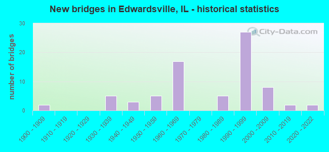
- New bridges - historical statistics
- 21900-1909
- 51930-1939
- 31940-1949
- 51950-1959
- 171960-1969
- 51980-1989
- 271990-1999
- 82000-2009
- 22010-2019
- 22020-2022
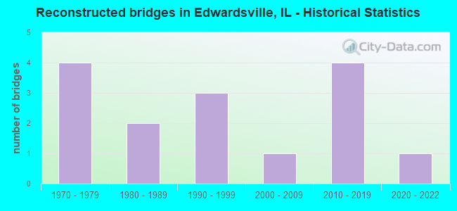
- Reconstructed bridges - Historical Statistics
- 41970-1979
- 21980-1989
- 31990-1999
- 12000-2009
- 42010-2019
- 12020-2022
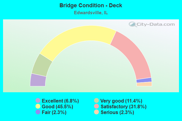
- Bridge Condition - Deck
- 6.8%Excellent
- 11.4%Very good
- 45.5%Good
- 31.8%Satisfactory
- 2.3%Fair
- 2.3%Serious
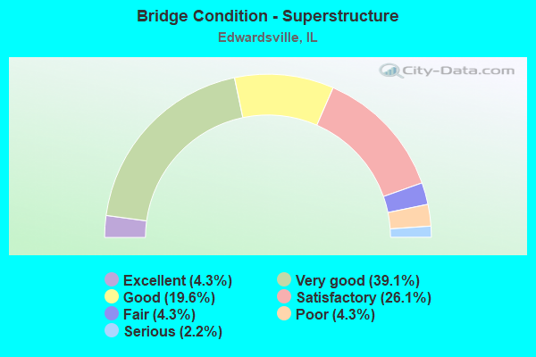
- Bridge Condition - Superstructure
- 4.3%Excellent
- 39.1%Very good
- 19.6%Good
- 26.1%Satisfactory
- 4.3%Fair
- 4.3%Poor
- 2.2%Serious
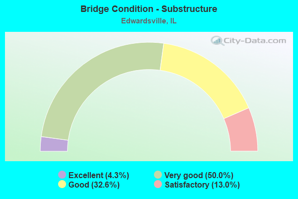
- Bridge Condition - Substructure
- 4.3%Excellent
- 50.0%Very good
- 32.6%Good
- 13.0%Satisfactory
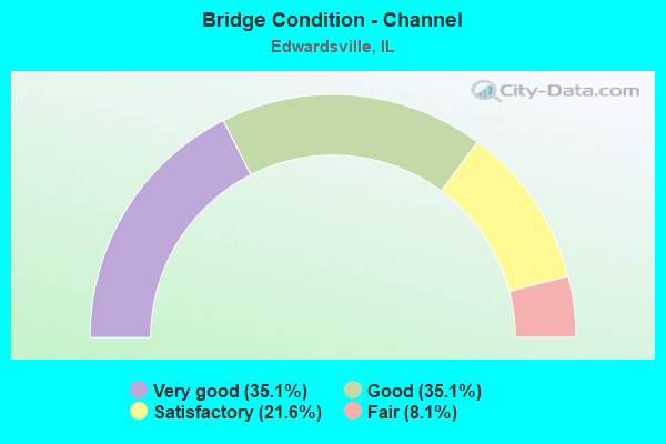
- Bridge Condition - Channel
- 35.1%Very good
- 35.1%Good
- 21.6%Satisfactory
- 8.1%Fair
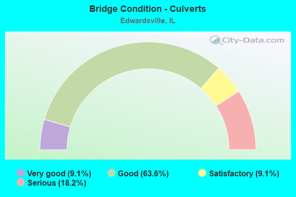
- Bridge Condition - Culverts
- 9.1%Very good
- 63.6%Good
- 9.1%Satisfactory
- 18.2%Serious
Find on map >> Show street view
Structure Number: 603261, Location: 1.3 MI SW POAG (Lat: 38.784233, Lng: -90.057794), Route carried "on" structure: County highway , Year Built: 1982, Status: Open, Structure Length: 1.58m (5.18ft), Average Daily Traffic: 300 (year 2021), Truck Traffic: 9%, Average Future Daily Traffic: 477 (year 2032), Design Load: HS 20, Features Intersected: COUNTY DITCH, Facility Carried by Structure: CH 19 POAG RD
Minimum Vertical Clearance: 30+ m (98+ ft), Kilometerpoint: 2.784, Lanes on structure: 2, Owner: County Highway Agency, Approaching Roadway Width: 7.3m (24.0ft), Skew: 2 degrees, Material/Design: Prestressed concrete, Design/Construction: Box Beam or Girders - Multiple, Number Of Spans In Main Unit: 1, Length of Maximum Span: 14.9m (48.9ft), Curb-To-Curb Width: 8.6m (28.2ft), Out-to-Out Width: 8.6m (28.2ft)
Condition: Deck: Satisfactory, Superstructure: Satisfactory, Substructure: Good, Channel: Very good, Operating Rating: 44.4 metric tons, Method Used To Determine Operating Rating: Assigned rating based on Load Factor Design (LFD) reported by rating factor (RF) using MS18 loading, Inventory Rating: 32.4 metric tons, Method Used To Determine Inventory Rating: Assigned rating based on Load Factor Design (LFD) reported by rating factor (RF) using MS18 loading, Structural Evaluation: Equal to present minimum criteria, Deck Geometry: Equal to present minimum criteria, Waterway Adequacy: Equal to present desirable criteria, Approach Roadway Alignment: Equal to present desirable criteria, Designated Inspection Frequency: Every 24 months, Inspection Date: January 2022, Deck Structure Type: Concrete Precast Panels, Wearing Surface/Protective System: Wearing Surface: Gravel
Find on map >> Show street view
Structure Number: 603301, Location: 3.3 MI E OF EDWARDSV (Lat: 38.818133, Lng: -89.865914), Route carried "on" structure: County highway , Year Built: 1989, Status: Open, Structure Length: 0.67m (2.20ft), Average Daily Traffic: 150 (year 2021), Truck Traffic: 22%, Average Future Daily Traffic: 186 (year 2032), Design Load: HS 20, Features Intersected: W. TRIB. SILVER CRK, Facility Carried by Structure: PIN OAK RD/ TR 225
Minimum Vertical Clearance: 30+ m (98+ ft), Kilometerpoint: 1.786, Lanes on structure: 2, Owner: Town or Township Highway Agency, Approaching Roadway Width: 6.1m (20.0ft), Skew: 3 degrees, Material/Design: Steel, Design/Construction: Culvert, Number Of Spans In Main Unit: 1, Length of Maximum Span: 6.7m (22.0ft)
Condition: Channel: Satisfactory, Culverts: Good, Operating Rating: 57.7 metric tons, Method Used To Determine Operating Rating: Load Factor (LF) rating reported by rating factor (RF) method using MS18 loading, Inventory Rating: 34.7 metric tons, Method Used To Determine Inventory Rating: Load Factor (LF) rating reported by rating factor (RF) method using MS18 loading, Structural Evaluation: Better than present minimum criteria, Waterway Adequacy: Better than present minimum criteria, Approach Roadway Alignment: Equal to present desirable criteria, Designated Inspection Frequency: Every 24 months, Inspection Date: March 2020
Find on map >> Show street view
Structure Number: 603317, Location: 1.1 MI. W. 157 (Lat: 38.812692, Lng: -89.986381), Route carried "on" structure: Other road , Year Built: 1966, Status: Open, Structure Length: 0.73m (2.40ft), Average Daily Traffic: 4,100 (year 2021), Truck Traffic: 5%, Average Future Daily Traffic: 6,890 (year 2032), Design Load: HS 20, Features Intersected: DELLAPLAIN BR., Facility Carried by Structure: POAG RD. CH69
Minimum Vertical Clearance: 30+ m (98+ ft), Kilometerpoint: 10.847, Lanes on structure: 2, Base Highway Network: Yes, Owner: County Highway Agency, Approaching Roadway Width: 18.3m (60.0ft), Skew: 2 degrees, Material/Design: Concrete continuous, Design/Construction: Culvert, Number Of Spans In Main Unit: 2, Length of Maximum Span: 3.5m (11.5ft)
Condition: Channel: Fair, Culverts: Very good, Operating Rating: 53.8 metric tons, Method Used To Determine Operating Rating: Field evaluation and documented engineering judgment, Inventory Rating: 32.4 metric tons, Method Used To Determine Inventory Rating: Field evaluation and documented engineering judgment, Structural Evaluation: Equal to present desirable criteria, Waterway Adequacy: Superior to present desirable criteria, Approach Roadway Alignment: Equal to present desirable criteria, Designated Inspection Frequency: Every 24 months, Inspection Date: Febuary 2020
Find on map >> Show street view
Structure Number: 603318, Location: 2.0 MI N OF TROY (Lat: 38.773553, Lng: -89.892528), Route carried "on" structure: County highway , Year Built: 1996, Status: Open, Structure Length: 2.79m (9.15ft), Average Daily Traffic: 200 (year 2021), Truck Traffic: 15%, Average Future Daily Traffic: 212 (year 2032), Design Load: HS 20, Features Intersected: WENDALL BRANCH, Facility Carried by Structure: E MICK RD/TR 261A
Minimum Vertical Clearance: 30+ m (98+ ft), Kilometerpoint: 0.676, Lanes on structure: 2, Owner: Town or Township Highway Agency, Approaching Roadway Width: 7.3m (24.0ft), Material/Design: Prestressed concrete, Design/Construction: Box Beam or Girders - Multiple, Number Of Spans In Main Unit: 3, Length of Maximum Span: 9.1m (29.9ft), Curb-To-Curb Width: 8.6m (28.2ft), Out-to-Out Width: 8.6m (28.2ft)
Condition: Deck: Good, Superstructure: Good, Substructure: Very good, Channel: Satisfactory, Operating Rating: 44.1 metric tons, Method Used To Determine Operating Rating: Assigned rating based on Load Factor Design (LFD) reported by rating factor (RF) using MS18 loading, Inventory Rating: 32.4 metric tons, Method Used To Determine Inventory Rating: Assigned rating based on Load Factor Design (LFD) reported by rating factor (RF) using MS18 loading, Structural Evaluation: Better than present minimum criteria, Deck Geometry: Equal to present minimum criteria, Waterway Adequacy: Equal to present desirable criteria, Approach Roadway Alignment: Equal to present desirable criteria, Designated Inspection Frequency: Every 48 months, Inspection Date: March 2020, Deck Structure Type: Concrete Precast Panels, Wearing Surface/Protective System: Wearing Surface: Bituminous, Membrane: Built-up
Find on map >> Show street view
Structure Number: 603331, Location: IL RT. 143 INTERSECT (Lat: 38.799200, Lng: -89.911831), Route carried "on" structure: Other road , Year Built: 2002, Status: Open, Structure Length: 0.78m (2.56ft), Average Daily Traffic: 1,550 (year 2021), Truck Traffic: 6%, Average Future Daily Traffic: 1,007 (year 2032), Design Load: HS 20+Mod, Features Intersected: LITTLE MOONEY CK, Facility Carried by Structure: RIDGEVIEW RD.
Minimum Vertical Clearance: 30+ m (98+ ft), Kilometerpoint: 0.016, Lanes on structure: 2, Owner: City or Municipal Highway Agency, Approaching Roadway Width: 7.3m (24.0ft), Material/Design: Concrete, Design/Construction: Frame, Number Of Spans In Main Unit: 1, Length of Maximum Span: 7.6m (24.9ft)
Condition: Superstructure: Very good, Substructure: Very good, Channel: Fair, Operating Rating: 44.1 metric tons, Method Used To Determine Operating Rating: Assigned rating based on Load Factor Design (LFD) reported by rating factor (RF) using MS18 loading, Inventory Rating: 32.4 metric tons, Method Used To Determine Inventory Rating: Assigned rating based on Load Factor Design (LFD) reported by rating factor (RF) using MS18 loading, Structural Evaluation: Equal to present desirable criteria, Waterway Adequacy: Equal to present desirable criteria, Approach Roadway Alignment: Equal to present desirable criteria, Designated Inspection Frequency: Every 48 months, Inspection Date: January 2021
Find on map >> Show street view
Structure Number: 603336, Location: EDWARDSVILLE (Lat: 38.787236, Lng: -89.934381), Route carried "on" structure: Other road , Year Built: 2008, Status: Open, Structure Length: 3.81m (12.50ft), Average Daily Traffic: 8,950 (year 2021), Truck Traffic: 3%, Average Future Daily Traffic: 9,010 (year 2032), Design Load: HS 20, Features Intersected: TRIB TO DUNLAP CRK, Facility Carried by Structure: FAU8902 GOVS PKWY
Minimum Vertical Clearance: 30+ m (98+ ft), Kilometerpoint: 4.184, Lanes on structure: 3, Base Highway Network: Yes, Owner: County Highway Agency, Approaching Roadway Width: 17.0m (55.8ft), Skew: 3 degrees, Material/Design: Steel, Design/Construction: Stringer/Multi-beam, Number Of Spans In Main Unit: 1, Length of Maximum Span: 37.2m (122.0ft), Curb-To-Curb Width: 17.0m (55.8ft), Out-to-Out Width: 18.0m (59.1ft)
Condition: Deck: Good, Superstructure: Very good, Substructure: Very good, Channel: Good, Operating Rating: 77.8 metric tons, Method Used To Determine Operating Rating: Load Factor (LF) rating reported by rating factor (RF) method using MS18 loading, Inventory Rating: 46.7 metric tons, Method Used To Determine Inventory Rating: Load Factor (LF) rating reported by rating factor (RF) method using MS18 loading, Structural Evaluation: Equal to present desirable criteria, Deck Geometry: Superior to present desirable criteria, Waterway Adequacy: Superior to present desirable criteria, Approach Roadway Alignment: Equal to present desirable criteria, Designated Inspection Frequency: Every 24 months, Inspection Date: Febuary 2020, Deck Structure Type: Concrete Cast-file-Place, Wearing Surface/Protective System: Deck Protection: Epoxy Coated Reinforcing
Find on map >> Show street view
Structure Number: 603342, Location: 2.5MI N EDWARDSVILLE (Lat: 38.852797, Lng: -89.927569), Route carried "on" structure: County highway , Year Built: 2006, Status: Open, Structure Length: 2.41m (7.91ft), Average Daily Traffic: 625 (year 2021), Truck Traffic: 11%, Average Future Daily Traffic: 795 (year 2032), Design Load: HS 20, Features Intersected: TRIB TO CAHOKIA CK, Facility Carried by Structure: OLD CARPENTER/TR 1
Minimum Vertical Clearance: 30+ m (98+ ft), Kilometerpoint: 4.957, Lanes on structure: 2, Owner: Town or Township Highway Agency, Approaching Roadway Width: 7.0m (23.0ft), Skew: 3 degrees, Material/Design: Prestressed concrete, Design/Construction: Box Beam or Girders - Multiple, Number Of Spans In Main Unit: 1, Length of Maximum Span: 23.2m (76.1ft), Curb-To-Curb Width: 9.3m (30.5ft), Out-to-Out Width: 9.3m (30.5ft)
Condition: Deck: Very good, Superstructure: Very good, Substructure: Very good, Channel: Very good, Operating Rating: 72.3 metric tons, Method Used To Determine Operating Rating: Load Factor (LF) rating reported by rating factor (RF) method using MS18 loading, Inventory Rating: 41.5 metric tons, Method Used To Determine Inventory Rating: Load Factor (LF) rating reported by rating factor (RF) method using MS18 loading, Structural Evaluation: Equal to present desirable criteria, Deck Geometry: Equal to present minimum criteria, Waterway Adequacy: Superior to present desirable criteria, Approach Roadway Alignment: Equal to present desirable criteria, Designated Inspection Frequency: Every 48 months, Inspection Date: September 2021, Deck Structure Type: Concrete Precast Panels, Wearing Surface/Protective System: Wearing Surface: Bituminous, Membrane: Built-up
Find on map >> Show street view
Structure Number: 603362, Location: 4 Mi NW Marine (Lat: 38.797531, Lng: -89.854589), Route carried "on" structure: County highway , Year Built: 2020, Status: Open, Structure Length: 1.65m (5.41ft), Average Daily Traffic: 50 (year 2021), Truck Traffic: 20%, Average Future Daily Traffic: 150 (year 2038), Design Load: HS 25 or greater, Features Intersected: Silver Creek, Facility Carried by Structure: TR 236 Pin Oak Roa
Minimum Vertical Clearance: 30+ m (98+ ft), Kilometerpoint: 1.641, Lanes on structure: 2, Owner: Town or Township Highway Agency, Approaching Roadway Width: 7.0m (23.0ft), Skew: 2 degrees, Material/Design: Concrete, Design/Construction: Slab, Number Of Spans In Main Unit: 1, Length of Maximum Span: 15.5m (50.9ft), Curb-To-Curb Width: 9.3m (30.5ft), Out-to-Out Width: 9.3m (30.5ft)
Condition: Deck: Excellent, Superstructure: Very good, Substructure: Excellent, Channel: Very good, Operating Rating: 58.0 metric tons, Method Used To Determine Operating Rating: Load and Resistance Factor Rating (LRFR) rating reported by rating factor(RF) method using HL-93 loadings, Inventory Rating: 44.7 metric tons, Method Used To Determine Inventory Rating: Load and Resistance Factor Rating (LRFR) rating reported by rating factor(RF) method using HL-93 loadings, Structural Evaluation: Equal to present desirable criteria, Deck Geometry: Better than present minimum criteria, Waterway Adequacy: High priority of corrective action, Approach Roadway Alignment: High priority of corrective action, Designated Inspection Frequency: Every 24 months, Inspection Date: March 2021, Deck Structure Type: Concrete Precast Panels, Wearing Surface/Protective System: Deck Protection: Epoxy Coated Reinforcing
Find on map >> Show street view
Structure Number: 603364, Location: 3.0 Mi N of Troy (Lat: 38.773581, Lng: -89.887481), Route carried "on" structure: County highway , Year Built: 2017, Status: Open, Structure Length: 2.50m (8.20ft), Average Daily Traffic: 200 (year 2021), Truck Traffic: 15%, Average Future Daily Traffic: 300 (year 2037), Design Load: HS 25 or greater, Features Intersected: Wendell Branch, Facility Carried by Structure: TR 261A E Mick Roa
Minimum Vertical Clearance: 30+ m (98+ ft), Kilometerpoint: 1.143, Lanes on structure: 2, Owner: Town or Township Highway Agency, Approaching Roadway Width: 9.1m (29.9ft), Material/Design: Prestressed concrete, Design/Construction: Box Beam or Girders - Multiple, Number Of Spans In Main Unit: 1, Length of Maximum Span: 24.5m (80.4ft), Curb-To-Curb Width: 9.2m (30.2ft), Out-to-Out Width: 9.2m (30.2ft)
Condition: Deck: Very good, Superstructure: Very good, Substructure: Very good, Channel: Good, Operating Rating: 42.1 metric tons, Method Used To Determine Operating Rating: Assigned ratings based on Load and Resistance Factor Design (LRFD) reported by rating factor (RF) using HL93 loadings, Inventory Rating: 32.4 metric tons, Method Used To Determine Inventory Rating: Assigned ratings based on Load and Resistance Factor Design (LRFD) reported by rating factor (RF) using HL93 loadings, Structural Evaluation: Equal to present desirable criteria, Deck Geometry: Equal to present minimum criteria, Waterway Adequacy: Equal to present desirable criteria, Approach Roadway Alignment: Equal to present desirable criteria, Designated Inspection Frequency: Every 48 months, Inspection Date: March 2020, Deck Structure Type: Concrete Precast Panels, Wearing Surface/Protective System: Wearing Surface: Bituminous, Membrane: Built-up
Find on map >> Show street view
Structure Number: 603368, Location: 0.5 Mi E Edwardsvill (Lat: 38.812856, Lng: -89.927086), Route carried "on" structure: County highway , Year Built: 2020, Status: Open, Structure Length: 1.88m (6.17ft), Average Daily Traffic: 200 (year 2021), Truck Traffic: 15%, Average Future Daily Traffic: 530 (year 2032), Design Load: HS 25 or greater, Features Intersected: Little Mooney Creek, Facility Carried by Structure: CH 42 Pin Oak Road
Minimum Vertical Clearance: 30+ m (98+ ft), Kilometerpoint: 0.660, Lanes on structure: 2, Owner: County Highway Agency, Approaching Roadway Width: 4.1m (13.5ft), Skew: 2 degrees, Material/Design: Steel continuous, Design/Construction: Stringer/Multi-beam, Number Of Spans In Main Unit: 1, Length of Maximum Span: 17.6m (57.7ft), Curb-To-Curb Width: 4.2m (13.8ft), Out-to-Out Width: 5.3m (17.4ft)
Condition: Deck: Excellent, Superstructure: Excellent, Substructure: Excellent, Channel: Very good, Operating Rating: 55.1 metric tons, Method Used To Determine Operating Rating: Load and Resistance Factor Rating (LRFR) rating reported by rating factor(RF) method using HL-93 loadings, Inventory Rating: 42.4 metric tons, Method Used To Determine Inventory Rating: Load and Resistance Factor Rating (LRFR) rating reported by rating factor(RF) method using HL-93 loadings, Structural Evaluation: Superior to present desirable criteria, Deck Geometry: High priority of replacement, Waterway Adequacy: Equal to present desirable criteria, Approach Roadway Alignment: Equal to present desirable criteria, Designated Inspection Frequency: Every 24 months, Inspection Date: May 2021, Deck Structure Type: Concrete Cast-file-Place, Wearing Surface/Protective System: Deck Protection: Epoxy Coated Reinforcing
Find on map >> Show street view
Structure Number: 6067, Location: .05 S SCHWARZ ST (Lat: 38.808867, Lng: -89.939633), Route carried "on" structure: Other road , Year Built: 1986, Status: Open, Structure Length: 0.82m (2.69ft), Average Daily Traffic: 900 (year 2021), Truck Traffic: 4%, Average Future Daily Traffic: 1,007 (year 2032), Design Load: HS 20, Features Intersected: OVERFLOW DUNLAP LAKE, Facility Carried by Structure: SCHWARZ RD/FAU8893
Minimum Vertical Clearance: 30+ m (98+ ft), Kilometerpoint: 0.097, Lanes on structure: 2, Owner: City or Municipal Highway Agency, Approaching Roadway Width: 7.9m (25.9ft), Skew: 1 degrees, Material/Design: Concrete, Design/Construction: Culvert, Number Of Spans In Main Unit: 2, Length of Maximum Span: 3.9m (12.8ft)
Condition: Channel: Satisfactory, Culverts: Good, Operating Rating: 44.4 metric tons, Method Used To Determine Operating Rating: Assigned rating based on Load Factor Design (LFD) reported by rating factor (RF) using MS18 loading, Inventory Rating: 32.4 metric tons, Method Used To Determine Inventory Rating: Assigned rating based on Load Factor Design (LFD) reported by rating factor (RF) using MS18 loading, Structural Evaluation: Better than present minimum criteria, Waterway Adequacy: Better than present minimum criteria, Approach Roadway Alignment: Equal to present desirable criteria, Designated Inspection Frequency: Every 48 months, Inspection Date: January 2022
Find on map >> Show street view
Structure Number: 606701, Location: .2 MI S. SCHWARZ (Lat: 38.807039, Lng: -89.939664), Route carried "on" structure: Other road , Year Built: 1986, Status: Open, Structure Length: 0.70m (2.30ft), Average Daily Traffic: 900 (year 2021), Truck Traffic: 4%, Average Future Daily Traffic: 1,007 (year 2032), Design Load: HS 20, Features Intersected: UNKNOWN CREEK, Facility Carried by Structure: SCHWARZ RD/FAU 889
Minimum Vertical Clearance: 30+ m (98+ ft), Kilometerpoint: 0.274, Lanes on structure: 2, Owner: City or Municipal Highway Agency, Approaching Roadway Width: 7.9m (25.9ft), Skew: 2 degrees, Material/Design: Concrete, Design/Construction: Culvert, Number Of Spans In Main Unit: 2, Length of Maximum Span: 3.4m (11.2ft)
Condition: Channel: Good, Culverts: Good, Operating Rating: 44.4 metric tons, Method Used To Determine Operating Rating: Assigned rating based on Load Factor Design (LFD) reported by rating factor (RF) using MS18 loading, Inventory Rating: 32.4 metric tons, Method Used To Determine Inventory Rating: Assigned rating based on Load Factor Design (LFD) reported by rating factor (RF) using MS18 loading, Structural Evaluation: Better than present minimum criteria, Waterway Adequacy: Better than present minimum criteria, Approach Roadway Alignment: Equal to present desirable criteria, Designated Inspection Frequency: Every 48 months, Inspection Date: January 2022
Find on map >> Show street view
Structure Number: 606702, Location: .85 EAST 157 (Lat: 38.784969, Lng: -89.964222), Route carried "on" structure: Other road , Year Built: 1989, Status: Posted for load, Structure Length: 9.31m (30.54ft), Average Daily Traffic: 12,600 (year 2021), Truck Traffic: 2%, Average Future Daily Traffic: 11,766 (year 2032), Design Load: HS 20, Features Intersected: MCT BIKE TRAIL, Facility Carried by Structure: CNTR GROVE/ FAU 88
Minimum Vertical Clearance: 30+ m (98+ ft), Kilometerpoint: 1.368, Lanes on structure: 3, Owner: City or Municipal Highway Agency, Approaching Roadway Width: 12.2m (40.0ft), Material/Design: Prestressed concrete, Design/Construction: Box Beam or Girders - Multiple, Number Of Spans In Main Unit: 4, Length of Maximum Span: 23.0m (75.5ft), Curb-To-Curb Width: 12.2m (40.0ft), Out-to-Out Width: 12.8m (42.0ft)
Condition: Deck: Serious, Superstructure: Serious, Substructure: Satisfactory, Operating Rating: 31.4 metric tons, Method Used To Determine Operating Rating: Load Factor (LF) rating reported by rating factor (RF) method using MS18 loading, Inventory Rating: 11.0 metric tons, Method Used To Determine Inventory Rating: Load Factor (LF) rating reported by rating factor (RF) method using MS18 loading, Structural Evaluation: High priority of corrective action, Deck Geometry: Meets minimum limits, Approach Roadway Alignment: Equal to present desirable criteria, Bridge Posting: Required (Relationship of Operating Rating to Maximum Legal Load: 30.0 - 39.9% below), Designated Inspection Frequency: Every 24 months, Other Special Inspection Frequency: Every 12 months, Inspection Date: January 2022, Other Special Inspection Date: January 2022, Deck Structure Type: Concrete Precast Panels, Wearing Surface/Protective System: Wearing Surface: Bituminous, Membrane: Built-up
Find on map >> Show street view
Structure Number: 606703, Location: 1.4MI E IL 159 (Lat: 38.781328, Lng: -89.936094), Route carried "on" structure: Other road , Year Built: 2003, Status: Open, Structure Length: 0.79m (2.59ft), Average Daily Traffic: 5,550 (year 2021), Truck Traffic: 4%, Average Future Daily Traffic: 8,586 (year 2032), Design Load: HS 20, Features Intersected: TRIB TO DUNLAP LAKE, Facility Carried by Structure: GOSHEN RD FAU 8905
Minimum Vertical Clearance: 30+ m (98+ ft), Kilometerpoint: 0.241, Lanes on structure: 2, Owner: City or Municipal Highway Agency, Approaching Roadway Width: 14.0m (45.9ft), Material/Design: Concrete, Design/Construction: Frame, Number Of Spans In Main Unit: 1, Length of Maximum Span: 7.3m (24.0ft), Curb or Sidewalk Widths: Left: 1.8m (5.9ft), Right: 0.0m, Curb-To-Curb Width: 14.0m (45.9ft), Out-to-Out Width: 14.0m (45.9ft)
Condition: Superstructure: Very good, Substructure: Very good, Channel: Good, Operating Rating: 44.1 metric tons, Method Used To Determine Operating Rating: Assigned rating based on Load Factor Design (LFD) reported by rating factor (RF) using MS18 loading, Inventory Rating: 32.4 metric tons, Method Used To Determine Inventory Rating: Assigned rating based on Load Factor Design (LFD) reported by rating factor (RF) using MS18 loading, Structural Evaluation: Equal to present desirable criteria, Deck Geometry: Superior to present desirable criteria, Waterway Adequacy: Better than present minimum criteria, Approach Roadway Alignment: Equal to present desirable criteria, Designated Inspection Frequency: Every 48 months, Inspection Date: January 2022
Find on map >> Show street view
Structure Number: 606705, Location: 75FT N EAST LAKE DR. (Lat: 38.791608, Lng: -89.933139), Route carried "on" structure: Other road , Year Built: 2009, Status: Open, Structure Length: 0.89m (2.92ft), Average Daily Traffic: 1,300 (year 2021), Truck Traffic: 4%, Average Future Daily Traffic: 2,120 (year 2032), Design Load: HS 20, Features Intersected: TRIB TO DUNLAP LAKE, Facility Carried by Structure: GERBER RD FAU 8894
Minimum Vertical Clearance: 30+ m (98+ ft), Kilometerpoint: 0.708, Lanes on structure: 2, Owner: City or Municipal Highway Agency, Approaching Roadway Width: 7.9m (25.9ft), Material/Design: Concrete, Design/Construction: Culvert, Number Of Spans In Main Unit: 3, Length of Maximum Span: 2.7m (8.9ft), Curb or Sidewalk Widths: Left: 1.5m (4.9ft), Right: 0.0m
Condition: Channel: Good, Culverts: Good, Operating Rating: 53.8 metric tons, Method Used To Determine Operating Rating: Field evaluation and documented engineering judgment, Inventory Rating: 32.4 metric tons, Method Used To Determine Inventory Rating: Field evaluation and documented engineering judgment, Structural Evaluation: Better than present minimum criteria, Waterway Adequacy: Equal to present minimum criteria, Approach Roadway Alignment: Equal to present desirable criteria, Designated Inspection Frequency: Every 48 months, Inspection Date: January 2021
Find on map >> Show street view
Structure Number: 606706, Location: 0.05 MI E GERBER RD (Lat: 38.791350, Lng: -89.932019), Route carried "on" structure: Other road , Year Built: 2009, Status: Open, Structure Length: 2.58m (8.46ft), Average Daily Traffic: 800 (year 2021), Truck Traffic: 4%, Average Future Daily Traffic: 901 (year 2032), Features Intersected: TRIB TO DUNLAP LAKE, Facility Carried by Structure: E LAKE DR FAU 8895
Minimum Vertical Clearance: 30+ m (98+ ft), Kilometerpoint: 2.977, Lanes on structure: 2, Owner: City or Municipal Highway Agency, Approaching Roadway Width: 7.9m (25.9ft), Material/Design: Concrete, Design/Construction: Culvert, Number Of Spans In Main Unit: 6, Length of Maximum Span: 4.0m (13.1ft), Curb or Sidewalk Widths: Left: 1.5m (4.9ft), Right: 0.0m
Condition: Channel: Satisfactory, Culverts: Good, Operating Rating: 53.8 metric tons, Method Used To Determine Operating Rating: Field evaluation and documented engineering judgment, Inventory Rating: 32.4 metric tons, Method Used To Determine Inventory Rating: Field evaluation and documented engineering judgment, Structural Evaluation: Better than present minimum criteria, Waterway Adequacy: Equal to present minimum criteria, Approach Roadway Alignment: Equal to present desirable criteria, Designated Inspection Frequency: Every 48 months, Inspection Date: January 2021
Find on map >> Show street view
Structure Number: 606707, Location: 0.11 MI E GERBER RD (Lat: 38.788147, Lng: -89.933533), Route carried "on" structure: City street , Year Built: 1994, Status: Open, Structure Length: 1.30m (4.27ft), Average Daily Traffic: 250 (year 2021), Truck Traffic: 4%, Average Future Daily Traffic: 100 (year 2032), Features Intersected: TRIB TO DUNLAP LAKE, Facility Carried by Structure: GERBER WOODS DRIVE
Minimum Vertical Clearance: 30+ m (98+ ft), Kilometerpoint: 0.177, Lanes on structure: 2, Owner: City or Municipal Highway Agency, Approaching Roadway Width: 9.1m (29.9ft), Material/Design: Steel, Design/Construction: Culvert, Number Of Spans In Main Unit: 4, Length of Maximum Span: 2.7m (8.9ft)
Condition: Channel: Satisfactory, Culverts: Satisfactory, Operating Rating: 89.1 metric tons, Method Used To Determine Operating Rating: Load Factor (LF) rating reported by rating factor (RF) method using MS18 loading, Inventory Rating: 89.1 metric tons, Method Used To Determine Inventory Rating: Load Factor (LF) rating reported by rating factor (RF) method using MS18 loading, Structural Evaluation: Equal to present minimum criteria, Waterway Adequacy: Meets minimum limits, Approach Roadway Alignment: Equal to present desirable criteria, Designated Inspection Frequency: Every 24 months, Inspection Date: January 2021
Find on map >> Show street view
Structure Number: 606708, Location: 0.03 MI E GERBER RD (Lat: 38.789425, Lng: -89.932492), Route carried "on" structure: City street , Year Built: 1991, Status: Open, Structure Length: 0.96m (3.15ft), Average Daily Traffic: 525 (year 2021), Truck Traffic: 4%, Average Future Daily Traffic: 133 (year 2032), Features Intersected: Trib to Dunlap Lake, Facility Carried by Structure: MS-1980 Willow Crk
Minimum Vertical Clearance: 30+ m (98+ ft), Kilometerpoint: 0.048, Lanes on structure: 2, Owner: City or Municipal Highway Agency, Approaching Roadway Width: 9.8m (32.2ft), Material/Design: Steel, Design/Construction: Culvert, Number Of Spans In Main Unit: 3, Length of Maximum Span: 2.7m (8.9ft), Curb or Sidewalk Widths: Left: 1.2m (3.9ft), Right: 1.2m (3.9ft)
Condition: Channel: Satisfactory, Culverts: Serious, Operating Rating: 88.8 metric tons, Method Used To Determine Operating Rating: Load Factor (LF) rating reported by rating factor (RF) method using MS18 loading, Inventory Rating: 88.8 metric tons, Method Used To Determine Inventory Rating: Load Factor (LF) rating reported by rating factor (RF) method using MS18 loading, Structural Evaluation: High priority of corrective action, Waterway Adequacy: Better than present minimum criteria, Approach Roadway Alignment: Equal to present desirable criteria, Designated Inspection Frequency: Every 24 months, Inspection Date: January 2021
Find on map >> Show street view
Structure Number: 606709, Location: 0.16 MI N GERBER RD (Lat: 38.790528, Lng: -89.936264), Route carried "on" structure: City street , Year Built: 1997, Status: Open, Structure Length: 0.74m (2.43ft), Average Daily Traffic: 250 (year 2021), Truck Traffic: 4%, Average Future Daily Traffic: 53 (year 2032), Features Intersected: TRIB TO DUNLAP LAKE, Facility Carried by Structure: STONEBROOKE DR
Minimum Vertical Clearance: 30+ m (98+ ft), Kilometerpoint: 0.177, Lanes on structure: 2, Owner: City or Municipal Highway Agency, Approaching Roadway Width: 8.5m (27.9ft), Material/Design: Steel, Design/Construction: Culvert, Number Of Spans In Main Unit: 3, Length of Maximum Span: 2.1m (6.9ft), Curb or Sidewalk Widths: Left: 1.1m (3.6ft), Right: 1.2m (3.9ft)
Condition: Channel: Satisfactory, Culverts: Serious, Operating Rating: 89.1 metric tons, Method Used To Determine Operating Rating: Load Factor (LF) rating reported by rating factor (RF) method using MS18 loading, Inventory Rating: 89.1 metric tons, Method Used To Determine Inventory Rating: Load Factor (LF) rating reported by rating factor (RF) method using MS18 loading, Structural Evaluation: High priority of corrective action, Waterway Adequacy: Meets minimum limits, Approach Roadway Alignment: Equal to present desirable criteria, Designated Inspection Frequency: Every 24 months, Inspection Date: January 2021
Find on map >> Show street view
Structure Number: 600123, Location: 1.25 M N 270 (Lat: 38.778778, Lng: -90.066217), Route carried "under" structure: County highway , Year Built: 1940, Structure Length: 0. m, Average Daily Traffic: 300 (year 2016), Truck Traffic: 16%, Features Intersected: ACCESS RD & NW RR, Facility Carried by Structure: ILL 111
Minimum Vertical Clearance: 8.28m (27.17ft), Kilometerpoint: 0.032, Lanes on structure: 2, Lanes under structure: 2, Material/Design: Steel continuous, Design/Construction: Stringer/Multi-beam, Length of Maximum Span: 25.9m (85.0ft)
Find on map >> Show street view
Structure Number: 600148, Location: 2M E EDWARDSVILLE (Lat: 38.795622, Lng: -89.895131), Route carried "under" structure: Interstate 55, Year Built: 1956, Structure Length: 0. m, Average Daily Traffic: 38,600 (year 2021), Truck Traffic: 20%, Features Intersected: FAI-55, Facility Carried by Structure: ILL 143
Minimum Vertical Clearance: 5.00m (16.40ft), Kilometerpoint: 36.048, Lanes on structure: 4, Lanes under structure: 4, Material/Design: Steel continuous, Design/Construction: Stringer/Multi-beam, Length of Maximum Span: 15.8m (51.8ft)
Find on map >> Show street view
Structure Number: 60016, Location: OLD 159 1.5 M W EDWR (Lat: 38.827572, Lng: -89.994436), Route carried "under" structure: Other road , Year Built: 1968, Structure Length: 0. m, Average Daily Traffic: 5,550 (year 2021), Truck Traffic: 6%, Features Intersected: SIU North Access Rd, Facility Carried by Structure: Old Alton Edwrdsvl
Minimum Vertical Clearance: 5.49m (18.01ft), Kilometerpoint: 0.692, Lanes on structure: 2, Lanes under structure: 4, Material/Design: Steel continuous, Design/Construction: Stringer/Multi-beam, Length of Maximum Span: 20.6m (67.6ft)
Find on map >> Show street view
Structure Number: 600178, Location: 2 M N JCT 270 (Lat: 38.782539, Lng: -89.898700), Route carried "under" structure: Interstate 55, Year Built: 1966, Structure Length: 0. m, Average Daily Traffic: 35,400 (year 2021), Truck Traffic: 24%, Features Intersected: FAI 55, Facility Carried by Structure: TR 251-A(GOSHEN RD
Minimum Vertical Clearance: 5.11m (16.77ft), Kilometerpoint: 34.552, Lanes on structure: 2, Lanes under structure: 4, Material/Design: Steel continuous, Design/Construction: Stringer/Multi-beam, Length of Maximum Span: 19.8m (65.0ft)
Find on map >> Show street view
Structure Number: 600179, Location: 2 M N JCT 143 & 55 (Lat: 38.831356, Lng: -89.878508), Route carried "under" structure: Interstate 55, Year Built: 1966, Structure Length: 0. m, Average Daily Traffic: 38,600 (year 2021), Truck Traffic: 20%, Features Intersected: FAI 55, Facility Carried by Structure: FAS 766 (FRUIT RD)
Minimum Vertical Clearance: 5.21m (17.09ft), Kilometerpoint: 40.313, Lanes on structure: 2, Lanes under structure: 4, Material/Design: Steel continuous, Design/Construction: Stringer/Multi-beam, Length of Maximum Span: 20.4m (66.9ft)
Find on map >> Show street view
Structure Number: 600191, Location: 1.3 MI W ILL 159 (Lat: 38.833611, Lng: -89.992983), Route carried "under" structure: Other road , Year Built: 1968, Structure Length: 0. m, Average Daily Traffic: 750 (year 2016), Truck Traffic: 9%, Features Intersected: N ENTRANCE TO SIUE, Facility Carried by Structure: ILL 143 WB
Minimum Vertical Clearance: 4.70m (15.42ft), Kilometerpoint: 0.016, Lanes on structure: 2, Lanes under structure: 2, Material/Design: Steel continuous, Design/Construction: Stringer/Multi-beam, Length of Maximum Span: 14.3m (46.9ft)
Find on map >> Show street view
Structure Number: 600191, Location: 1.3 MI W ILL 159 (Lat: 38.833664, Lng: -89.993167), Route carried "under" structure: Other road , Year Built: 1968, Structure Length: 0. m, Average Daily Traffic: 950 (year 2016), Truck Traffic: 9%, Features Intersected: N ENTRANCE TO SIUE, Facility Carried by Structure: ILL 143 WB
Minimum Vertical Clearance: 4.70m (15.42ft), Kilometerpoint: 1.030, Lanes on structure: 2, Lanes under structure: 2, Material/Design: Steel continuous, Design/Construction: Stringer/Multi-beam, Length of Maximum Span: 14.3m (46.9ft)
Find on map >> Show street view
Structure Number: 600192, Location: 1.3 MI W ILL 159 (Lat: 38.833428, Lng: -89.993289), Route carried "under" structure: Other road , Year Built: 1968, Structure Length: 0. m, Average Daily Traffic: 5,550 (year 2021), Truck Traffic: 6%, Features Intersected: N ENTRANCE TO SIUE, Facility Carried by Structure: ILL 143 EB
Minimum Vertical Clearance: 4.70m (15.42ft), Kilometerpoint: 0.016, Lanes on structure: 2, Lanes under structure: 2, Material/Design: Steel continuous, Design/Construction: Stringer/Multi-beam, Length of Maximum Span: 14.3m (46.9ft)
Find on map >> Show street view
Structure Number: 600245, Location: 2 M WEST OF IL 157 (Lat: 38.762311, Lng: -90.043389), Route carried "under" structure: Other road , Year Built: 1994, Structure Length: 0. m, Average Daily Traffic: 3,900 (year 2016), Truck Traffic: 13%, Features Intersected: OVER IL 255 (FAP310), Facility Carried by Structure: CHAIN OF ROCKS ROA
Minimum Vertical Clearance: 6.10m (20.01ft), Kilometerpoint: 0.966, Lanes on structure: 2, Lanes under structure: 1, Material/Design: Steel continuous, Design/Construction: Stringer/Multi-beam, Length of Maximum Span: 45.1m (148.0ft)
Find on map >> Show street view
Structure Number: 600245, Location: 2 M WEST OF IL 157 (Lat: 38.761694, Lng: -90.044175), Route carried "under" structure: Other road , Year Built: 1994, Structure Length: 0. m, Average Daily Traffic: 3,500 (year 2016), Truck Traffic: 15%, Features Intersected: OVER IL 255 (FAP310), Facility Carried by Structure: CHAIN OF ROCKS ROA
Minimum Vertical Clearance: 5.11m (16.77ft), Kilometerpoint: 0.692, Lanes on structure: 2, Lanes under structure: 1, Material/Design: Steel continuous, Design/Construction: Stringer/Multi-beam, Length of Maximum Span: 45.1m (148.0ft)
Find on map >> Show street view
Structure Number: 600245, Location: 2 M WEST OF IL 157 (Lat: 38.762408, Lng: -90.043608), Route carried "under" structure: State highway 255, Year Built: 1994, Structure Length: 0. m, Average Daily Traffic: 36,800 (year 2021), Truck Traffic: 14%, Features Intersected: OVER IL 255 (FAP310), Facility Carried by Structure: CHAIN OF ROCKS ROA
Minimum Vertical Clearance: 5.26m (17.26ft), Kilometerpoint: 0.515, Lanes on structure: 2, Lanes under structure: 6, Material/Design: Steel continuous, Design/Construction: Stringer/Multi-beam, Length of Maximum Span: 45.1m (148.0ft)
Find on map >> Show street view
Structure Number: 600245, Location: 2 M WEST OF IL 157 (Lat: 38.762350, Lng: -90.044347), Route carried "under" structure: Other road , Year Built: 1994, Structure Length: 0. m, Average Daily Traffic: 4,150 (year 2016), Truck Traffic: 14%, Features Intersected: OVER IL 255 (FAP310), Facility Carried by Structure: CHAIN OF ROCKS ROA
Minimum Vertical Clearance: 6.32m (20.73ft), Kilometerpoint: 0.306, Lanes on structure: 2, Lanes under structure: 1, Material/Design: Steel continuous, Design/Construction: Stringer/Multi-beam, Length of Maximum Span: 45.1m (148.0ft)
Find on map >> Show street view
Structure Number: 600272, Location: 1.25 M N OF I-270 (Lat: 38.777378, Lng: -90.043842), Route carried "under" structure: City street , Year Built: 1994, Structure Length: 0. m, Average Daily Traffic: 5,500 (year 2021), Truck Traffic: 19%, Features Intersected: COMM DR & CTY DITCH, Facility Carried by Structure: IL 255 NB (FAP310N
Minimum Vertical Clearance: 4.88m (16.01ft), Kilometerpoint: 0.048, Lanes on structure: 2, Lanes under structure: 4, Material/Design: Steel continuous, Design/Construction: Stringer/Multi-beam, Length of Maximum Span: 31.4m (103.0ft)
Find on map >> Show street view
Structure Number: 600273, Location: 1.25 M N OF I-270 (Lat: 38.777489, Lng: -90.044097), Route carried "under" structure: City street , Year Built: 1994, Structure Length: 0. m, Average Daily Traffic: 5,500 (year 2021), Truck Traffic: 19%, Features Intersected: COMM DR & CTY DITCH, Facility Carried by Structure: IL 255 SB (FAP310S
Minimum Vertical Clearance: 4.88m (16.01ft), Kilometerpoint: 0.016, Lanes on structure: 2, Lanes under structure: 4, Material/Design: Steel continuous, Design/Construction: Stringer/Multi-beam, Length of Maximum Span: 31.4m (103.0ft)
Find on map >> Show street view
Structure Number: 600274, Location: 2.5 MI N OF I-270 (Lat: 38.792828, Lng: -90.044903), Route carried "under" structure: County highway , Year Built: 1995, Structure Length: 0. m, Average Daily Traffic: 300 (year 2021), Truck Traffic: 9%, Features Intersected: OLD POAG & N+S RR, Facility Carried by Structure: IL 255 NB
Minimum Vertical Clearance: 9.80m (32.15ft), Kilometerpoint: 1.352, Lanes on structure: 2, Lanes under structure: 2, Material/Design: Steel continuous, Design/Construction: Stringer/Multi-beam, Length of Maximum Span: 25.9m (85.0ft)
Find on map >> Show street view
Structure Number: 600275, Location: 2.5 MI N OF I-270 (Lat: 38.792653, Lng: -90.045183), Route carried "under" structure: County highway , Year Built: 1995, Structure Length: 0. m, Average Daily Traffic: 300 (year 2021), Truck Traffic: 9%, Features Intersected: OLD POAG & N+S RR, Facility Carried by Structure: IL 255 SB
Minimum Vertical Clearance: 9.80m (32.15ft), Kilometerpoint: 1.384, Lanes on structure: 2, Lanes under structure: 2, Material/Design: Steel continuous, Design/Construction: Stringer/Multi-beam, Length of Maximum Span: 25.9m (85.0ft)
Find on map >> Show street view
Structure Number: 600276, Location: 2.70 MI NORTH OF 270 (Lat: 38.800464, Lng: -90.044044), Route carried "under" structure: Other road , Year Built: 1995, Structure Length: 0. m, Average Daily Traffic: 5,500 (year 2021), Truck Traffic: 7%, Features Intersected: NEW POAG RD/LEVEE RD, Facility Carried by Structure: IL 255 NB (FAP310N
Minimum Vertical Clearance: 5.36m (17.59ft), Kilometerpoint: 5.037, Lanes on structure: 2, Lanes under structure: 4, Material/Design: Steel continuous, Design/Construction: Stringer/Multi-beam, Length of Maximum Span: 19.8m (65.0ft)
Find on map >> Show street view
Structure Number: 600277, Location: 2.70 MI NORTH OF 270 (Lat: 38.800489, Lng: -90.044394), Route carried "under" structure: Other road , Year Built: 1995, Structure Length: 0. m, Average Daily Traffic: 5,500 (year 2021), Truck Traffic: 7%, Features Intersected: NEW POAG RD/LEVEE RD, Facility Carried by Structure: IL 255 SB (FAP310S
Minimum Vertical Clearance: 5.46m (17.91ft), Kilometerpoint: 5.005, Lanes on structure: 2, Lanes under structure: 4, Material/Design: Steel continuous, Design/Construction: Stringer/Multi-beam, Length of Maximum Span: 20.0m (65.6ft)
Find on map >> Show street view
Structure Number: 609918, Location: E. OF ENT. TO S.I.U. (Lat: 38.830247, Lng: -89.993219), Route carried "under" structure: County highway , Year Built: 1900, Structure Length: 0. m, Average Daily Traffic: 75 (year 2021), Truck Traffic: 19%, Features Intersected: TR 146D, Facility Carried by Structure: IT RR
Minimum Vertical Clearance: 3.66m (12.01ft), Kilometerpoint: 0.193, Lanes under structure: 2, Material/Design: Steel, Length of Maximum Span: 8.5m (27.9ft)