Bridge Statistics for Effingham, Illinois (IL)
Condition, Traffic, Stress, Structural Evaluation, Project Costs
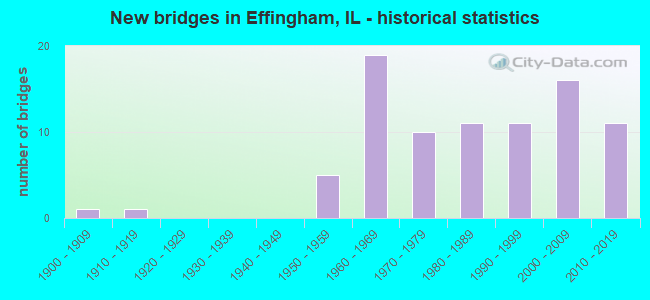
- New bridges - historical statistics
- 11900-1909
- 11910-1919
- 51950-1959
- 191960-1969
- 101970-1979
- 111980-1989
- 111990-1999
- 162000-2009
- 112010-2019
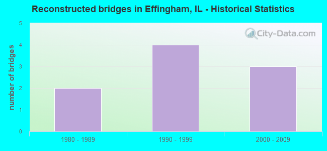
- Reconstructed bridges - Historical Statistics
- 21980-1989
- 41990-1999
- 32000-2009
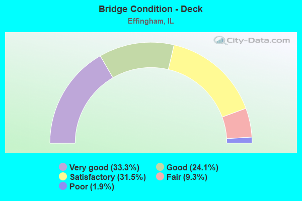
- Bridge Condition - Deck
- 33.3%Very good
- 24.1%Good
- 31.5%Satisfactory
- 9.3%Fair
- 1.9%Poor
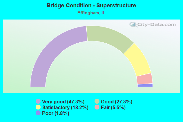
- Bridge Condition - Superstructure
- 47.3%Very good
- 27.3%Good
- 18.2%Satisfactory
- 5.5%Fair
- 1.8%Poor
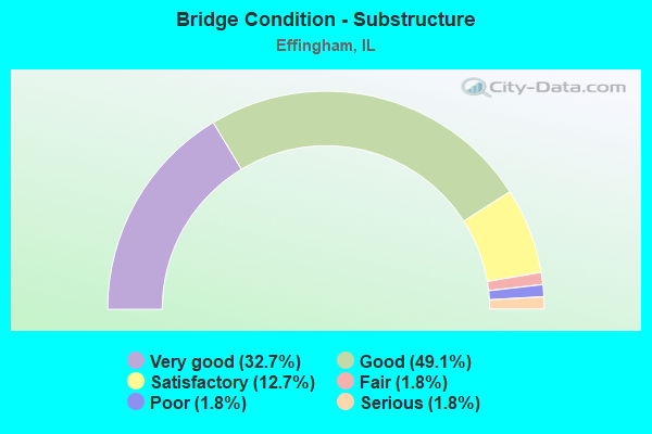
- Bridge Condition - Substructure
- 32.7%Very good
- 49.1%Good
- 12.7%Satisfactory
- 1.8%Fair
- 1.8%Poor
- 1.8%Serious
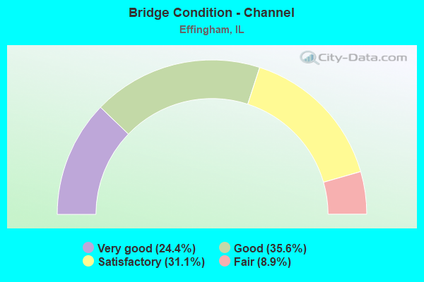
- Bridge Condition - Channel
- 24.4%Very good
- 35.6%Good
- 31.1%Satisfactory
- 8.9%Fair
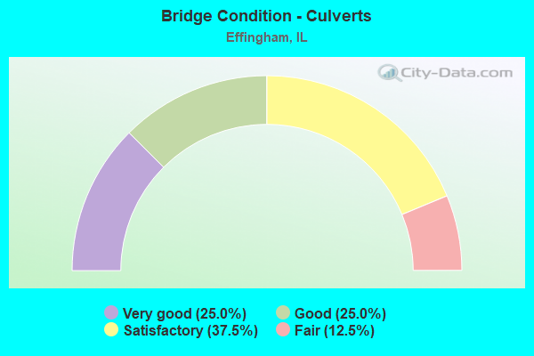
- Bridge Condition - Culverts
- 25.0%Very good
- 25.0%Good
- 37.5%Satisfactory
- 12.5%Fair
Find on map >> Show street view
Structure Number: 253204, Location: 3 MI N EFFINGHAM (Lat: 39.172122, Lng: -88.556278), Route carried "on" structure: County highway , Year Built: 1977, Status: Open, Structure Length: 4.57m (14.99ft), Average Daily Traffic: 650 (year 2018), Truck Traffic: 3%, Average Future Daily Traffic: 428 (year 2032), Design Load: HS 20, Features Intersected: GREEN CREEK, Facility Carried by Structure: CH-9
Minimum Vertical Clearance: 30+ m (98+ ft), Kilometerpoint: 3.476, Lanes on structure: 2, Owner: County Highway Agency, Approaching Roadway Width: 8.5m (27.9ft), Material/Design: Concrete, Design/Construction: Channel Beam, Number Of Spans In Main Unit: 4, Length of Maximum Span: 11.0m (36.1ft), Curb-To-Curb Width: 7.5m (24.6ft), Out-to-Out Width: 7.9m (25.9ft)
Condition: Deck: Very good, Superstructure: Satisfactory, Substructure: Very good, Channel: Good, Operating Rating: 51.5 metric tons, Method Used To Determine Operating Rating: Load Factor (LF) rating reported by rating factor (RF) method using MS18 loading, Inventory Rating: 30.8 metric tons, Method Used To Determine Inventory Rating: Load Factor (LF) rating reported by rating factor (RF) method using MS18 loading, Structural Evaluation: Equal to present minimum criteria, Deck Geometry: Meets minimum limits, Waterway Adequacy: Equal to present desirable criteria, Approach Roadway Alignment: Better than present minimum criteria, Designated Inspection Frequency: Every 24 months, Inspection Date: December 2020, Deck Structure Type: Concrete Precast Panels, Wearing Surface/Protective System: Wearing Surface: Gravel
Find on map >> Show street view
Structure Number: 253205, Location: 1 MI W ST MARY'S (Lat: 39.197114, Lng: -88.535831), Route carried "on" structure: County highway , Year Built: 1977, Status: Open, Structure Length: 3.54m (11.61ft), Average Daily Traffic: 300 (year 2018), Truck Traffic: 2%, Average Future Daily Traffic: 348 (year 2032), Design Load: HS 20, Features Intersected: GREEN CREEK, Facility Carried by Structure: FAS-1709 (CH-8)
Minimum Vertical Clearance: 30+ m (98+ ft), Kilometerpoint: 7.580, Lanes on structure: 2, Owner: County Highway Agency, Approaching Roadway Width: 9.1m (29.9ft), Material/Design: Concrete, Design/Construction: Channel Beam, Number Of Spans In Main Unit: 3, Length of Maximum Span: 11.6m (38.1ft), Curb-To-Curb Width: 8.6m (28.2ft), Out-to-Out Width: 9.1m (29.9ft)
Condition: Deck: Good, Superstructure: Satisfactory, Substructure: Good, Channel: Satisfactory, Operating Rating: 49.9 metric tons, Method Used To Determine Operating Rating: Load Factor (LF) rating reported by rating factor (RF) method using MS18 loading, Inventory Rating: 19.1 metric tons, Method Used To Determine Inventory Rating: Load Factor (LF) rating reported by rating factor (RF) method using MS18 loading, Structural Evaluation: Somewhat better than minimum adequacy, Deck Geometry: Equal to present minimum criteria, Waterway Adequacy: Superior to present desirable criteria, Approach Roadway Alignment: Equal to present desirable criteria, Designated Inspection Frequency: Every 24 months, Inspection Date: November 2020, Deck Structure Type: Concrete Precast Panels, Wearing Surface/Protective System: Wearing Surface: Gravel, Membrane: Built-up
Find on map >> Show street view
Structure Number: 253206, Location: 4.5 MI N EFFINGHAM (Lat: 39.197289, Lng: -88.575989), Route carried "on" structure: County highway , Year Built: 1980, Status: Open, Structure Length: 6.74m (22.11ft), Average Daily Traffic: 300 (year 2018), Truck Traffic: 5%, Average Future Daily Traffic: 375 (year 2032), Design Load: HS 20, Features Intersected: LITTLE WABASH RIVER, Facility Carried by Structure: FAS-1709 (CH-8)
Minimum Vertical Clearance: 30+ m (98+ ft), Kilometerpoint: 4.136, Lanes on structure: 2, Owner: County Highway Agency, Approaching Roadway Width: 7.3m (24.0ft), Skew: 3 degrees, Material/Design: Prestressed concrete, Design/Construction: Box Beam or Girders - Multiple, Number Of Spans In Main Unit: 3, Length of Maximum Span: 21.9m (71.9ft), Curb-To-Curb Width: 9.1m (29.9ft), Out-to-Out Width: 9.1m (29.9ft)
Condition: Deck: Very good, Superstructure: Very good, Substructure: Very good, Channel: Satisfactory, Operating Rating: 57.7 metric tons, Method Used To Determine Operating Rating: Load Factor (LF) rating reported by rating factor (RF) method using MS18 loading, Inventory Rating: 34.7 metric tons, Method Used To Determine Inventory Rating: Load Factor (LF) rating reported by rating factor (RF) method using MS18 loading, Structural Evaluation: Equal to present desirable criteria, Deck Geometry: Equal to present minimum criteria, Waterway Adequacy: Better than present minimum criteria, Approach Roadway Alignment: Equal to present desirable criteria, Designated Inspection Frequency: Every 48 months, Inspection Date: December 2018, Deck Structure Type: Concrete Precast Panels, Wearing Surface/Protective System: Wearing Surface: Gravel
Find on map >> Show street view
Structure Number: 253214, Location: 2 MI S FUNKHOUSER (Lat: 39.073103, Lng: -88.616964), Route carried "on" structure: County highway , Year Built: 1991, Status: Open, Structure Length: 3.41m (11.19ft), Average Daily Traffic: 1,000 (year 2018), Truck Traffic: 7%, Average Future Daily Traffic: 696 (year 2032), Design Load: HS 20, Features Intersected: LILY CREEK, Facility Carried by Structure: FAS-1710 (CH-24)
Minimum Vertical Clearance: 30+ m (98+ ft), Kilometerpoint: 3.621, Lanes on structure: 2, Owner: County Highway Agency, Approaching Roadway Width: 6.7m (22.0ft), Skew: 3 degrees, Material/Design: Prestressed concrete, Design/Construction: Box Beam or Girders - Multiple, Number Of Spans In Main Unit: 3, Length of Maximum Span: 15.2m (49.9ft), Curb-To-Curb Width: 8.6m (28.2ft), Out-to-Out Width: 8.6m (28.2ft)
Condition: Deck: Very good, Superstructure: Very good, Substructure: Very good, Channel: Good, Operating Rating: 62.5 metric tons, Method Used To Determine Operating Rating: Load Factor (LF) rating reported by rating factor (RF) method using MS18 loading, Inventory Rating: 37.6 metric tons, Method Used To Determine Inventory Rating: Load Factor (LF) rating reported by rating factor (RF) method using MS18 loading, Structural Evaluation: Equal to present desirable criteria, Deck Geometry: Somewhat better than minimum adequacy, Waterway Adequacy: Superior to present desirable criteria, Approach Roadway Alignment: Equal to present minimum criteria, Designated Inspection Frequency: Every 48 months, Inspection Date: November 2021, Deck Structure Type: Concrete Precast Panels, Wearing Surface/Protective System: Wearing Surface: Gravel
Find on map >> Show street view
Structure Number: 253217, Location: 1 MI W EFFINGHAM (Lat: 39.117236, Lng: -88.587433), Route carried "on" structure: County highway , Year Built: 1995, Status: Open, Structure Length: 4.31m (14.14ft), Average Daily Traffic: 950 (year 2018), Truck Traffic: 4%, Average Future Daily Traffic: 857 (year 2032), Design Load: HS 20, Features Intersected: LITTLE WABASH RIVER, Facility Carried by Structure: TR-85B
Minimum Vertical Clearance: 30+ m (98+ ft), Kilometerpoint: 0.901, Lanes on structure: 2, Owner: Town or Township Highway Agency, Approaching Roadway Width: 8.5m (27.9ft), Material/Design: Prestressed concrete, Design/Construction: Box Beam or Girders - Multiple, Number Of Spans In Main Unit: 3, Number Of Approach Spans: 1, Length of Maximum Span: 18.3m (60.0ft), Curb-To-Curb Width: 8.5m (27.9ft), Out-to-Out Width: 8.5m (27.9ft)
Condition: Deck: Very good, Superstructure: Very good, Substructure: Very good, Channel: Very good, Operating Rating: 62.9 metric tons, Method Used To Determine Operating Rating: Load Factor (LF) rating reported by rating factor (RF) method using MS18 loading, Inventory Rating: 37.6 metric tons, Method Used To Determine Inventory Rating: Load Factor (LF) rating reported by rating factor (RF) method using MS18 loading, Structural Evaluation: Equal to present desirable criteria, Deck Geometry: Somewhat better than minimum adequacy, Waterway Adequacy: Equal to present minimum criteria, Approach Roadway Alignment: Equal to present desirable criteria, Designated Inspection Frequency: Every 48 months, Inspection Date: November 2021, Deck Structure Type: Concrete Precast Panels, Wearing Surface/Protective System: Wearing Surface: Gravel
Find on map >> Show street view
Structure Number: 25322, Location: 0.5 MI NW EFFINGHAM (Lat: 39.136478, Lng: -88.579097), Route carried "on" structure: Other road , Year Built: 2000, Status: Open, Structure Length: 6.32m (20.73ft), Average Daily Traffic: 2,500 (year 2018), Truck Traffic: 4%, Average Future Daily Traffic: 536 (year 2032), Design Load: HS 20, Features Intersected: LITTLE WABASH RIVER, Facility Carried by Structure: FAU 8390
Minimum Vertical Clearance: 30+ m (98+ ft), Kilometerpoint: 1.931, Lanes on structure: 2, Owner: County Highway Agency, Approaching Roadway Width: 6.1m (20.0ft), Skew: 2 degrees, Material/Design: Prestressed concrete, Design/Construction: Box Beam or Girders - Multiple, Number Of Spans In Main Unit: 1, Length of Maximum Span: 24.4m (80.1ft), Curb-To-Curb Width: 8.2m (26.9ft), Out-to-Out Width: 8.2m (26.9ft)
Condition: Deck: Good, Superstructure: Good, Substructure: Very good, Channel: Very good, Operating Rating: 69.3 metric tons, Method Used To Determine Operating Rating: Load Factor (LF) rating reported by rating factor (RF) method using MS18 loading, Inventory Rating: 41.5 metric tons, Method Used To Determine Inventory Rating: Load Factor (LF) rating reported by rating factor (RF) method using MS18 loading, Structural Evaluation: Better than present minimum criteria, Deck Geometry: High priority of corrective action, Waterway Adequacy: Superior to present desirable criteria, Approach Roadway Alignment: Equal to present desirable criteria, Designated Inspection Frequency: Every 48 months, Inspection Date: January 2021, Deck Structure Type: Concrete Precast Panels, Wearing Surface/Protective System: Wearing Surface: Gravel
Find on map >> Show street view
Structure Number: 253309, Location: NW EFFINGHAM (Lat: 39.148033, Lng: -88.575633), Route carried "on" structure: County highway , Year Built: 2006, Status: Open, Structure Length: 3.35m (10.99ft), Average Daily Traffic: 500 (year 2018), Truck Traffic: 5%, Average Future Daily Traffic: 482 (year 2032), Design Load: HS 20, Features Intersected: GREEN CREEK, Facility Carried by Structure: TR 160
Minimum Vertical Clearance: 30+ m (98+ ft), Kilometerpoint: 2.671, Lanes on structure: 2, Owner: Town or Township Highway Agency, Approaching Roadway Width: 6.7m (22.0ft), Skew: 2 degrees, Material/Design: Prestressed concrete, Design/Construction: Box Beam or Girders - Multiple, Number Of Spans In Main Unit: 3, Length of Maximum Span: 12.2m (40.0ft), Curb-To-Curb Width: 8.5m (27.9ft), Out-to-Out Width: 8.5m (27.9ft)
Condition: Deck: Good, Superstructure: Good, Substructure: Very good, Channel: Very good, Operating Rating: 44.1 metric tons, Method Used To Determine Operating Rating: Assigned rating based on Load Factor Design (LFD) reported by rating factor (RF) using MS18 loading, Inventory Rating: 32.4 metric tons, Method Used To Determine Inventory Rating: Assigned rating based on Load Factor Design (LFD) reported by rating factor (RF) using MS18 loading, Structural Evaluation: Better than present minimum criteria, Deck Geometry: Somewhat better than minimum adequacy, Waterway Adequacy: Equal to present desirable criteria, Approach Roadway Alignment: Equal to present desirable criteria, Designated Inspection Frequency: Every 48 months, Inspection Date: January 2021, Deck Structure Type: Concrete Precast Panels, Wearing Surface/Protective System: Wearing Surface: Gravel
Find on map >> Show street view
Structure Number: 253311, Location: 1 MI E EFFINGHAM (Lat: 39.120250, Lng: -88.514083), Route carried "on" structure: County highway , Year Built: 2004, Status: Open, Structure Length: 0.91m (2.99ft), Average Daily Traffic: 125 (year 2018), Truck Traffic: 2%, Average Future Daily Traffic: 54 (year 2032), Design Load: HS 20, Features Intersected: SALT CREEK BRANCH, Facility Carried by Structure: TR 232
Minimum Vertical Clearance: 30+ m (98+ ft), Kilometerpoint: 0.338, Lanes on structure: 2, Owner: Town or Township Highway Agency, Approaching Roadway Width: 5.5m (18.0ft), Material/Design: Concrete, Design/Construction: Frame, Number Of Spans In Main Unit: 1, Length of Maximum Span: 9.1m (29.9ft), Curb-To-Curb Width: 7.3m (24.0ft), Out-to-Out Width: 7.3m (24.0ft)
Condition: Superstructure: Very good, Substructure: Very good, Channel: Very good, Operating Rating: 44.1 metric tons, Method Used To Determine Operating Rating: Assigned rating based on Load Factor Design (LFD) reported by rating factor (RF) using MS18 loading, Inventory Rating: 32.4 metric tons, Method Used To Determine Inventory Rating: Assigned rating based on Load Factor Design (LFD) reported by rating factor (RF) using MS18 loading, Structural Evaluation: Equal to present desirable criteria, Deck Geometry: Somewhat better than minimum adequacy, Waterway Adequacy: Equal to present desirable criteria, Approach Roadway Alignment: Equal to present minimum criteria, Designated Inspection Frequency: Every 48 months, Inspection Date: December 2018
Find on map >> Show street view
Structure Number: 253321, Location: 1 MI SE OF EFFINGHAM (Lat: 39.095328, Lng: -88.505147), Route carried "on" structure: County highway , Year Built: 2010, Status: Open, Structure Length: 0.77m (2.53ft), Average Daily Traffic: 200 (year 2018), Truck Traffic: 10%, Average Future Daily Traffic: 268 (year 2032), Design Load: HS 20+Mod, Features Intersected: TRIB OF SALT CREEK, Facility Carried by Structure: TR 242A
Minimum Vertical Clearance: 30+ m (98+ ft), Kilometerpoint: 3.347, Lanes on structure: 2, Owner: Town or Township Highway Agency, Approaching Roadway Width: 5.5m (18.0ft), Material/Design: Aluminum, Iron, Design/Construction: Frame, Number Of Spans In Main Unit: 1, Length of Maximum Span: 7.7m (25.3ft)
Condition: Deck: Very good, Superstructure: Very good, Substructure: Very good, Channel: Satisfactory, Operating Rating: 66.1 metric tons, Method Used To Determine Operating Rating: Load Factor (LF) rating reported by rating factor (RF) method using MS18 loading, Inventory Rating: 49.6 metric tons, Method Used To Determine Inventory Rating: Load Factor (LF) rating reported by rating factor (RF) method using MS18 loading, Structural Evaluation: Equal to present desirable criteria, Waterway Adequacy: Equal to present desirable criteria, Approach Roadway Alignment: Equal to present desirable criteria, Designated Inspection Frequency: Every 24 months, Inspection Date: December 2020
Find on map >> Show street view
Structure Number: 255007, Location: 0.25 MI N EFFINGHAM (Lat: 39.134081, Lng: -88.530589), Route carried "on" structure: Other road , Year Built: 1977, Status: Open, Structure Length: 0.79m (2.59ft), Average Daily Traffic: 500 (year 2018), Truck Traffic: 4%, Average Future Daily Traffic: 428 (year 2032), Design Load: HS 20, Features Intersected: BRANCH SALT CREEK, Facility Carried by Structure: FAU-8351
Minimum Vertical Clearance: 30+ m (98+ ft), Kilometerpoint: 2.832, Lanes on structure: 2, Owner: City or Municipal Highway Agency, Approaching Roadway Width: 6.7m (22.0ft), Material/Design: Concrete, Design/Construction: Culvert, Number Of Spans In Main Unit: 2, Length of Maximum Span: 3.9m (12.8ft), Curb-To-Curb Width: 9.1m (29.9ft), Out-to-Out Width: 9.8m (32.2ft)
Condition: Channel: Fair, Culverts: Good, Operating Rating: 54.4 metric tons, Method Used To Determine Operating Rating: Load Factor (LF) rating reported by rating factor (RF) method using MS18 loading, Inventory Rating: 32.7 metric tons, Method Used To Determine Inventory Rating: Load Factor (LF) rating reported by rating factor (RF) method using MS18 loading, Structural Evaluation: Better than present minimum criteria, Deck Geometry: Equal to present minimum criteria, Waterway Adequacy: Equal to present desirable criteria, Approach Roadway Alignment: Equal to present desirable criteria, Designated Inspection Frequency: Every 48 months, Inspection Date: Febuary 2019, Deck Structure Type: Concrete Cast-file-Place, Wearing Surface/Protective System: Wearing Surface: Bituminous
Find on map >> Show street view
Structure Number: 255022, Location: 1 MI W TEUTOPOLIS (Lat: 39.120522, Lng: -88.504703), Route carried "on" structure: County highway , Year Built: 1988, Status: Open, Structure Length: 0.85m (2.79ft), Average Daily Traffic: 600 (year 2018), Truck Traffic: 2%, Average Future Daily Traffic: 910 (year 2032), Design Load: HS 20, Features Intersected: BRANCH SALT CREEK, Facility Carried by Structure: TR-242A
Minimum Vertical Clearance: 30+ m (98+ ft), Kilometerpoint: 0.547, Lanes on structure: 2, Owner: Town or Township Highway Agency, Approaching Roadway Width: 6.1m (20.0ft), Skew: 3 degrees, Material/Design: Concrete, Design/Construction: Culvert, Number Of Spans In Main Unit: 2, Length of Maximum Span: 3.9m (12.8ft)
Condition: Channel: Satisfactory, Culverts: Very good, Operating Rating: 44.4 metric tons, Method Used To Determine Operating Rating: Assigned rating based on Load Factor Design (LFD) reported by rating factor (RF) using MS18 loading, Inventory Rating: 32.4 metric tons, Method Used To Determine Inventory Rating: Assigned rating based on Load Factor Design (LFD) reported by rating factor (RF) using MS18 loading, Structural Evaluation: Equal to present desirable criteria, Waterway Adequacy: Equal to present desirable criteria, Approach Roadway Alignment: Better than present minimum criteria, Designated Inspection Frequency: Every 48 months, Inspection Date: November 2021, Wearing Surface/Protective System: Wearing Surface: Gravel
Find on map >> Show street view
Structure Number: 256004, Location: BANKER ST - EFFINGHM (Lat: 39.117033, Lng: -88.546211), Route carried "on" structure: US 45, Year Built: 1996, Status: Open, Structure Length: 3.83m (12.57ft), Average Daily Traffic: 14,500 (year 2021), Truck Traffic: 4%, Average Future Daily Traffic: 18,100 (year 2032), Design Load: HS 20, Features Intersected: CSXT RR
Minimum Vertical Clearance: 30+ m (98+ ft), Kilometerpoint: 277.154, Lanes on structure: 4, Lanes under structure: 2, Base Highway Network: Yes, Owner: State Highway Agency, Approaching Roadway Width: 17.1m (56.1ft), Skew: 13 degrees, Material/Design: Steel, Design/Construction: Stringer/Multi-beam, Number Of Spans In Main Unit: 1, Length of Maximum Span: 36.7m (120.4ft), Curb or Sidewalk Widths: Left: 0.0m, Right: 1.8m (5.9ft), Curb-To-Curb Width: 17.1m (56.1ft), Out-to-Out Width: 19.7m (64.6ft)
Condition: Deck: Satisfactory, Superstructure: Good, Substructure: Good, Operating Rating: 89.1 metric tons, Method Used To Determine Operating Rating: Load Factor (LF) rating reported by rating factor (RF) method using MS18 loading, Inventory Rating: 58.3 metric tons, Method Used To Determine Inventory Rating: Load Factor (LF) rating reported by rating factor (RF) method using MS18 loading, Structural Evaluation: Better than present minimum criteria, Deck Geometry: Somewhat better than minimum adequacy, Underclear: Somewhat better than minimum adequacy, Approach Roadway Alignment: Equal to present desirable criteria, Designated Inspection Frequency: Every 24 months, Inspection Date: January 2022, Deck Structure Type: Concrete Cast-file-Place, Wearing Surface/Protective System: Deck Protection: Epoxy Coated Reinforcing
Find on map >> Show street view
Structure Number: 256005, Location: EFFINGHAM (Lat: 39.114103, Lng: -88.560933), Route carried "on" structure: Other road , Year Built: 2001, Status: Open, Structure Length: 11.04m (36.22ft), Average Daily Traffic: 4,200 (year 2021), Truck Traffic: 18%, Average Future Daily Traffic: 7,711 (year 2032), Design Load: HS 20, Features Intersected: FAU 8357,#6801,CSXT, Facility Carried by Structure: FAU 8361(RANEY ST)
Minimum Vertical Clearance: 30+ m (98+ ft), Kilometerpoint: 0.869, Lanes on structure: 2, Lanes under structure: 4, Base Highway Network: Yes, Owner: City or Municipal Highway Agency, Approaching Roadway Width: 15.8m (51.8ft), Skew: 1 degrees, Material/Design: Steel continuous, Design/Construction: Stringer/Multi-beam, Number Of Spans In Main Unit: 3, Length of Maximum Span: 44.6m (146.3ft), Curb or Sidewalk Widths: Left: 1.8m (5.9ft), Right: 0.0m, Curb-To-Curb Width: 17.1m (56.1ft), Out-to-Out Width: 17.1m (56.1ft)
Condition: Deck: Good, Superstructure: Very good, Substructure: Satisfactory, Operating Rating: 44.1 metric tons, Method Used To Determine Operating Rating: Assigned rating based on Load Factor Design (LFD) reported by rating factor (RF) using MS18 loading, Inventory Rating: 32.4 metric tons, Method Used To Determine Inventory Rating: Assigned rating based on Load Factor Design (LFD) reported by rating factor (RF) using MS18 loading, Structural Evaluation: Equal to present minimum criteria, Deck Geometry: Superior to present desirable criteria, Underclear: Equal to present minimum criteria, Approach Roadway Alignment: Equal to present desirable criteria, Designated Inspection Frequency: Every 24 months, Inspection Date: Febuary 2021, Deck Structure Type: Concrete Cast-file-Place, Wearing Surface/Protective System: Deck Protection: Epoxy Coated Reinforcing
Find on map >> Show street view
Structure Number: 256008, Location: EFFINGHAM-NE PART (Lat: 39.141439, Lng: -88.534736), Route carried "on" structure: Other road , Year Built: 2004, Status: Open, Structure Length: 0.81m (2.66ft), Average Daily Traffic: 4,600 (year 2018), Truck Traffic: 4%, Average Future Daily Traffic: 5,355 (year 2032), Design Load: HS 20, Features Intersected: CREEK, Facility Carried by Structure: TECHNOLOGY DR/FU83
Minimum Vertical Clearance: 30+ m (98+ ft), Kilometerpoint: 0.064, Lanes on structure: 2, Owner: City or Municipal Highway Agency, Approaching Roadway Width: 10.1m (33.1ft), Skew: 2 degrees, Material/Design: Concrete, Design/Construction: Culvert, Number Of Spans In Main Unit: 2, Length of Maximum Span: 8.1m (26.6ft)
Condition: Channel: Fair, Culverts: Good, Operating Rating: 53.8 metric tons, Method Used To Determine Operating Rating: Field evaluation and documented engineering judgment, Inventory Rating: 32.4 metric tons, Method Used To Determine Inventory Rating: Field evaluation and documented engineering judgment, Structural Evaluation: Better than present minimum criteria, Waterway Adequacy: Superior to present desirable criteria, Approach Roadway Alignment: Equal to present desirable criteria, Designated Inspection Frequency: Every 48 months, Inspection Date: Febuary 2019
Find on map >> Show street view
Structure Number: 256009, Location: W EDGE EFFINGHAM (Lat: 39.125028, Lng: -88.574372), Route carried "on" structure: Other road , Year Built: 2007, Status: Open, Structure Length: 6.34m (20.80ft), Average Daily Traffic: 4,450 (year 2018), Truck Traffic: 6%, Average Future Daily Traffic: 857 (year 2032), Design Load: HS 20, Features Intersected: TRIB TO L'L WABASH R, Facility Carried by Structure: FAU 8384/OUTERBELT
Minimum Vertical Clearance: 30+ m (98+ ft), Kilometerpoint: 2.092, Lanes on structure: 2, Base Highway Network: Yes, Owner: City or Municipal Highway Agency, Approaching Roadway Width: 9.1m (29.9ft), Skew: 1 degrees, Material/Design: Prestressed concrete, Design/Construction: Stringer/Multi-beam, Number Of Spans In Main Unit: 2, Length of Maximum Span: 31.2m (102.4ft), Curb or Sidewalk Widths: Left: 1.5m (4.9ft), Right: 0.0m, Curb-To-Curb Width: 9.1m (29.9ft), Out-to-Out Width: 11.5m (37.7ft)
Condition: Deck: Good, Superstructure: Good, Substructure: Very good, Channel: Good, Operating Rating: 44.1 metric tons, Method Used To Determine Operating Rating: Assigned rating based on Load Factor Design (LFD) reported by rating factor (RF) using MS18 loading, Inventory Rating: 32.4 metric tons, Method Used To Determine Inventory Rating: Assigned rating based on Load Factor Design (LFD) reported by rating factor (RF) using MS18 loading, Structural Evaluation: Better than present minimum criteria, Deck Geometry: Meets minimum limits, Waterway Adequacy: Superior to present desirable criteria, Approach Roadway Alignment: Equal to present desirable criteria, Designated Inspection Frequency: Every 24 months, Inspection Date: Febuary 2021, Deck Structure Type: Concrete Cast-file-Place, Wearing Surface/Protective System: Deck Protection: Epoxy Coated Reinforcing
Find on map >> Show street view
Structure Number: 259903, Location: 2 MI W EFFINGHAM (Lat: 39.123442, Lng: -88.617706), Route carried "on" structure: County highway , Year Built: 1957, Status: Open, Structure Length: 2.62m (8.60ft), Average Daily Traffic: 900 (year 2018), Truck Traffic: 4%, Average Future Daily Traffic: 1,178 (year 2032), Features Intersected: LAKE SARA SPILLWAY, Facility Carried by Structure: TR-77A
Minimum Vertical Clearance: 30+ m (98+ ft), Kilometerpoint: 1.384, Lanes on structure: 2, Owner: Private, Approaching Roadway Width: 7.9m (25.9ft), Material/Design: Concrete, Design/Construction: Tee Beam, Number Of Spans In Main Unit: 3, Length of Maximum Span: 8.8m (28.9ft), Curb or Sidewalk Widths: Left: 0.6m (2.0ft), Right: 0.6m (2.0ft), Curb-To-Curb Width: 7.3m (24.0ft), Out-to-Out Width: 9.1m (29.9ft)
Condition: Deck: Good, Superstructure: Good, Substructure: Good, Channel: Very good, Operating Rating: 40.5 metric tons, Method Used To Determine Operating Rating: Field evaluation and documented engineering judgment, Inventory Rating: 24.3 metric tons, Method Used To Determine Inventory Rating: Field evaluation and documented engineering judgment, Structural Evaluation: Equal to present minimum criteria, Deck Geometry: Meets minimum limits, Waterway Adequacy: Equal to present desirable criteria, Approach Roadway Alignment: Better than present minimum criteria, Designated Inspection Frequency: Every 24 months, Underwater Inspection Frequency: Every 60 months, Inspection Date: December 2020, Underwater Inspection Date: August 2021, Deck Structure Type: Concrete Precast Panels, Wearing Surface/Protective System: Wearing Surface: Gravel
Find on map >> Show street view
Structure Number: 333, Location: 2.5 MI N DAHLGREN (Lat: 38.242642, Lng: -88.684775), Route carried "on" structure: County highway , Year Built: 1957, Status: Open, Structure Length: 3.51m (11.52ft), Average Daily Traffic: 175 (year 2017), Truck Traffic: 15%, Average Future Daily Traffic: 250 (year 2032), Design Load: HS 15, Features Intersected: AUXIER CREEK, Facility Carried by Structure: FAS-1879
Minimum Vertical Clearance: 30+ m (98+ ft), Kilometerpoint: 1.545, Lanes on structure: 2, Owner: County Highway Agency, Approaching Roadway Width: 10.4m (34.1ft), Material/Design: Steel continuous, Design/Construction: Stringer/Multi-beam, Number Of Spans In Main Unit: 3, Length of Maximum Span: 12.8m (42.0ft), Curb-To-Curb Width: 7.3m (24.0ft), Out-to-Out Width: 8.7m (28.5ft)
Condition: Deck: Good, Superstructure: Good, Substructure: Good, Channel: Good, Operating Rating: 46.7 metric tons, Method Used To Determine Operating Rating: Load Factor (LF) rating reported by rating factor (RF) method using MS18 loading, Inventory Rating: 27.9 metric tons, Method Used To Determine Inventory Rating: Load Factor (LF) rating reported by rating factor (RF) method using MS18 loading, Structural Evaluation: Better than present minimum criteria, Deck Geometry: Somewhat better than minimum adequacy, Waterway Adequacy: Better than present minimum criteria, Approach Roadway Alignment: Better than present minimum criteria, Designated Inspection Frequency: Every 24 months, Inspection Date: Febuary 2020, Deck Structure Type: Concrete Cast-file-Place, Wearing Surface/Protective System: Wearing Surface: Bituminous
Find on map >> Show street view
Structure Number: 333107, Location: 2 MI S DALE (Lat: 37.965747, Lng: -88.494442), Route carried "on" structure: County highway , Year Built: 1909, Status: Open, Structure Length: 1.41m (4.63ft), Average Daily Traffic: 50 (year 2017), Truck Traffic: 14%, Average Future Daily Traffic: 150 (year 2032), Features Intersected: CONTRARY CREEK, Facility Carried by Structure: TR-324
Minimum Vertical Clearance: 30+ m (98+ ft), Kilometerpoint: 3.235, Lanes on structure: 1, Owner: Town or Township Highway Agency, Approaching Roadway Width: 6.7m (22.0ft), Material/Design: Steel, Design/Construction: Stringer/Multi-beam, Number Of Spans In Main Unit: 1, Length of Maximum Span: 12.8m (42.0ft), Curb-To-Curb Width: 5.9m (19.4ft), Out-to-Out Width: 5.9m (19.4ft)
Condition: Deck: Good, Superstructure: Satisfactory, Substructure: Serious, Channel: Fair, Operating Rating: 46.7 metric tons, Method Used To Determine Operating Rating: Load Factor (LF) rating reported by rating factor (RF) method using MS18 loading, Inventory Rating: 27.9 metric tons, Method Used To Determine Inventory Rating: Load Factor (LF) rating reported by rating factor (RF) method using MS18 loading, Structural Evaluation: High priority of corrective action, Deck Geometry: Meets minimum limits, Waterway Adequacy: High priority of corrective action, Approach Roadway Alignment: Equal to present minimum criteria, Length Of Structure Improvement: 2.01m (6.59ft), Designated Inspection Frequency: Every 24 months, Inspection Date: Febuary 2020, Bridge Improvement Cost: $74,000, Roadway Improvement Cost: $7,000, Total Project Cost: $112,000, Deck Structure Type: Concrete Cast-file-Place
Find on map >> Show street view
Structure Number: 333195, Location: 2 MI E MACEDONIA (Lat: 38.053356, Lng: -88.666347), Route carried "on" structure: County highway , Year Built: 1979, Status: Open, Structure Length: 1.07m (3.51ft), Average Daily Traffic: 75 (year 2017), Truck Traffic: 8%, Average Future Daily Traffic: 50 (year 2032), Features Intersected: TRIB BIG MUDDY, Facility Carried by Structure: TR-269
Minimum Vertical Clearance: 30+ m (98+ ft), Kilometerpoint: 3.138, Lanes on structure: 2, Owner: Town or Township Highway Agency, Approaching Roadway Width: 7.3m (24.0ft), Material/Design: Steel, Design/Construction: Stringer/Multi-beam, Number Of Spans In Main Unit: 1, Length of Maximum Span: 10.1m (33.1ft), Curb-To-Curb Width: 6.1m (20.0ft), Out-to-Out Width: 6.1m (20.0ft)
Condition: Deck: Good, Superstructure: Good, Substructure: Good, Channel: Good, Operating Rating: 88.8 metric tons, Method Used To Determine Operating Rating: Allowable Stress (AS) rating reported by rating factor (RF) method using MS18 loading, Inventory Rating: 60.9 metric tons, Method Used To Determine Inventory Rating: Allowable Stress (AS) rating reported by rating factor (RF) method using MS18 loading, Structural Evaluation: Better than present minimum criteria, Deck Geometry: Somewhat better than minimum adequacy, Waterway Adequacy: Better than present minimum criteria, Approach Roadway Alignment: Equal to present minimum criteria, Designated Inspection Frequency: Every 48 months, Inspection Date: Febuary 2018, Deck Structure Type: Concrete Precast Panels
Find on map >> Show street view
Structure Number: 333212, Location: 4 MI NE DAHLGREN (Lat: 38.235961, Lng: -88.629367), Route carried "on" structure: County highway , Year Built: 1984, Status: Open, Structure Length: 1.89m (6.20ft), Average Daily Traffic: 25 (year 2017), Truck Traffic: 16%, Average Future Daily Traffic: 75 (year 2032), Design Load: HS 20, Features Intersected: SHELTON CREEK, Facility Carried by Structure: TR-108
Minimum Vertical Clearance: 30+ m (98+ ft), Kilometerpoint: 2.253, Lanes on structure: 2, Owner: Town or Township Highway Agency, Approaching Roadway Width: 7.3m (24.0ft), Skew: 1 degrees, Material/Design: Prestressed concrete, Design/Construction: Box Beam or Girders - Multiple, Number Of Spans In Main Unit: 1, Length of Maximum Span: 17.7m (58.1ft), Curb-To-Curb Width: 7.4m (24.3ft), Out-to-Out Width: 7.4m (24.3ft)
Condition: Deck: Very good, Superstructure: Very good, Substructure: Good, Channel: Satisfactory, Operating Rating: 44.4 metric tons, Method Used To Determine Operating Rating: Assigned rating based on Load Factor Design (LFD) reported by rating factor (RF) using MS18 loading, Inventory Rating: 32.4 metric tons, Method Used To Determine Inventory Rating: Assigned rating based on Load Factor Design (LFD) reported by rating factor (RF) using MS18 loading, Structural Evaluation: Better than present minimum criteria, Deck Geometry: Equal to present minimum criteria, Waterway Adequacy: Equal to present desirable criteria, Approach Roadway Alignment: Better than present minimum criteria, Designated Inspection Frequency: Every 48 months, Inspection Date: Febuary 2018, Deck Structure Type: Concrete Precast Panels
Find on map >> Show street view
Structure Number: 333217, Location: 1.5 MI SW DALE (Lat: 37.976936, Lng: -88.508428), Route carried "on" structure: County highway , Year Built: 1982, Status: Open, Structure Length: 3.93m (12.89ft), Average Daily Traffic: 25 (year 2017), Truck Traffic: 16%, Average Future Daily Traffic: 50 (year 2032), Design Load: HS 20, Features Intersected: HOGG CREEK, Facility Carried by Structure: TR-318
Minimum Vertical Clearance: 30+ m (98+ ft), Kilometerpoint: 1.996, Lanes on structure: 2, Owner: Town or Township Highway Agency, Approaching Roadway Width: 7.3m (24.0ft), Material/Design: Prestressed concrete, Design/Construction: Box Beam or Girders - Multiple, Number Of Spans In Main Unit: 3, Length of Maximum Span: 14.9m (48.9ft), Curb-To-Curb Width: 7.4m (24.3ft), Out-to-Out Width: 7.4m (24.3ft)
Condition: Deck: Good, Superstructure: Good, Substructure: Good, Channel: Good, Operating Rating: 44.4 metric tons, Method Used To Determine Operating Rating: Assigned rating based on Load Factor Design (LFD) reported by rating factor (RF) using MS18 loading, Inventory Rating: 32.4 metric tons, Method Used To Determine Inventory Rating: Assigned rating based on Load Factor Design (LFD) reported by rating factor (RF) using MS18 loading, Structural Evaluation: Better than present minimum criteria, Deck Geometry: Equal to present minimum criteria, Waterway Adequacy: Equal to present desirable criteria, Approach Roadway Alignment: Better than present minimum criteria, Designated Inspection Frequency: Every 48 months, Inspection Date: January 2022, Deck Structure Type: Concrete Precast Panels
Find on map >> Show street view
Structure Number: 333222, Location: 3.5 NE MACEDONIA (Lat: 38.103042, Lng: -88.681811), Route carried "on" structure: County highway , Year Built: 1984, Status: Open, Structure Length: 2.32m (7.61ft), Average Daily Traffic: 50 (year 2017), Truck Traffic: 6%, Average Future Daily Traffic: 75 (year 2032), Design Load: HS 20, Features Intersected: SULLIVAN BRANCH, Facility Carried by Structure: TR-191
Minimum Vertical Clearance: 30+ m (98+ ft), Kilometerpoint: 2.028, Lanes on structure: 2, Owner: Town or Township Highway Agency, Approaching Roadway Width: 6.1m (20.0ft), Skew: 4 degrees, Material/Design: Concrete, Design/Construction: Channel Beam, Number Of Spans In Main Unit: 3, Length of Maximum Span: 8.2m (26.9ft), Curb-To-Curb Width: 8.0m (26.2ft), Out-to-Out Width: 8.0m (26.2ft)
Condition: Deck: Very good, Superstructure: Very good, Substructure: Very good, Channel: Good, Operating Rating: 44.4 metric tons, Method Used To Determine Operating Rating: Assigned rating based on Load Factor Design (LFD) reported by rating factor (RF) using MS18 loading, Inventory Rating: 32.4 metric tons, Method Used To Determine Inventory Rating: Assigned rating based on Load Factor Design (LFD) reported by rating factor (RF) using MS18 loading, Structural Evaluation: Equal to present desirable criteria, Deck Geometry: Equal to present minimum criteria, Waterway Adequacy: Equal to present desirable criteria, Approach Roadway Alignment: Equal to present desirable criteria, Designated Inspection Frequency: Every 48 months, Inspection Date: Febuary 2018, Deck Structure Type: Concrete Precast Panels
Find on map >> Show street view
Structure Number: 333228, Location: W EDGE MCLEANSBORO (Lat: 38.096392, Lng: -88.551881), Route carried "on" structure: County highway , Year Built: 1983, Status: Open, Structure Length: 1.26m (4.13ft), Average Daily Traffic: 500 (year 2017), Truck Traffic: 5%, Average Future Daily Traffic: 650 (year 2032), Design Load: HS 20, Features Intersected: TRIB BEAR CREEK, Facility Carried by Structure: TR-205
Minimum Vertical Clearance: 30+ m (98+ ft), Kilometerpoint: 4.039, Lanes on structure: 2, Owner: Town or Township Highway Agency, Approaching Roadway Width: 7.3m (24.0ft), Material/Design: Prestressed concrete, Design/Construction: Box Beam or Girders - Multiple, Number Of Spans In Main Unit: 1, Length of Maximum Span: 11.6m (38.1ft), Curb-To-Curb Width: 7.4m (24.3ft), Out-to-Out Width: 7.4m (24.3ft)
Condition: Deck: Very good, Superstructure: Very good, Substructure: Very good, Channel: Good, Operating Rating: 44.4 metric tons, Method Used To Determine Operating Rating: Assigned rating based on Load Factor Design (LFD) reported by rating factor (RF) using MS18 loading, Inventory Rating: 32.4 metric tons, Method Used To Determine Inventory Rating: Assigned rating based on Load Factor Design (LFD) reported by rating factor (RF) using MS18 loading, Structural Evaluation: Equal to present desirable criteria, Deck Geometry: Meets minimum limits, Waterway Adequacy: Better than present minimum criteria, Approach Roadway Alignment: Equal to present desirable criteria, Designated Inspection Frequency: Every 48 months, Inspection Date: January 2022, Deck Structure Type: Concrete Precast Panels, Wearing Surface/Protective System: Wearing Surface: Bituminous
Find on map >> Show street view
Structure Number: 33325, Location: 3.75 MI W CORNERVILL (Lat: 37.906803, Lng: -88.681306), Route carried "on" structure: County highway , Year Built: 1989, Status: Open, Structure Length: 1.87m (6.14ft), Average Daily Traffic: 100 (year 2020), Truck Traffic: 23%, Average Future Daily Traffic: 51 (year 2032), Design Load: HS 20, Features Intersected: MIDDLE FORK CREEK, Facility Carried by Structure: TR-1 (SALINE CO)
Minimum Vertical Clearance: 30+ m (98+ ft), Kilometerpoint: 2.205, Lanes on structure: 2, Owner: Town or Township Highway Agency, Approaching Roadway Width: 7.3m (24.0ft), Skew: 1 degrees, Material/Design: Prestressed concrete, Design/Construction: Box Beam or Girders - Multiple, Number Of Spans In Main Unit: 1, Length of Maximum Span: 18.3m (60.0ft), Curb-To-Curb Width: 7.4m (24.3ft), Out-to-Out Width: 7.4m (24.3ft)
Condition: Deck: Very good, Superstructure: Very good, Substructure: Very good, Channel: Very good, Operating Rating: 44.4 metric tons, Method Used To Determine Operating Rating: Assigned rating based on Load Factor Design (LFD) reported by rating factor (RF) using MS18 loading, Inventory Rating: 32.4 metric tons, Method Used To Determine Inventory Rating: Assigned rating based on Load Factor Design (LFD) reported by rating factor (RF) using MS18 loading, Structural Evaluation: Equal to present desirable criteria, Deck Geometry: Equal to present minimum criteria, Waterway Adequacy: Better than present minimum criteria, Approach Roadway Alignment: Equal to present desirable criteria, Designated Inspection Frequency: Every 48 months, Inspection Date: January 2022, Deck Structure Type: Concrete Precast Panels
Find on map >> Show street view
Structure Number: 250001, Location: TRI-LEVEL SW EFF (Lat: 39.094331, Lng: -88.581311), Route carried "under" structure: Interstate 70, Year Built: 1960, Structure Length: 0. m, Average Daily Traffic: 24,800 (year 2021), Truck Traffic: 41%, Features Intersected: FAI-70 EB, Facility Carried by Structure: FAI-57 SB
Minimum Vertical Clearance: 5.33m (17.49ft), Kilometerpoint: 154.976, Lanes on structure: 2, Lanes under structure: 2, Material/Design: Steel, Design/Construction: Stringer/Multi-beam, Length of Maximum Span: 19.3m (63.3ft)
Find on map >> Show street view
Structure Number: 250002, Location: TRI-LEVEL NE EFF (Lat: 39.149053, Lng: -88.507628), Route carried "under" structure: Interstate 70, Year Built: 1960, Structure Length: 0. m, Average Daily Traffic: 25,800 (year 2021), Truck Traffic: 58%, Features Intersected: FAI-70 WB, Facility Carried by Structure: FAI-57 NB
Minimum Vertical Clearance: 5.33m (17.49ft), Kilometerpoint: 164.760, Lanes on structure: 2, Lanes under structure: 2, Material/Design: Steel continuous, Design/Construction: Stringer/Multi-beam, Length of Maximum Span: 21.9m (71.9ft)
Find on map >> Show street view
Structure Number: 250018, Location: TRI-LEVEL SW EFFINGH (Lat: 39.094964, Lng: -88.578681), Route carried "under" structure: Interstate 57, Year Built: 1960, Structure Length: 0. m, Average Daily Traffic: 20,500 (year 2021), Truck Traffic: 52%, Features Intersected: FAI-57 SB, Facility Carried by Structure: FAI-70/RMP-1285
Minimum Vertical Clearance: 5.44m (17.85ft), Kilometerpoint: 253.320, Lanes on structure: 1, Lanes under structure: 2, Material/Design: Steel continuous, Design/Construction: Stringer/Multi-beam, Length of Maximum Span: 18.9m (62.0ft)
Find on map >> Show street view
Structure Number: 250019, Location: TRI-LEVEL NE EFFINGH (Lat: 39.150697, Lng: -88.507517), Route carried "under" structure: Interstate 57, Year Built: 1960, Structure Length: 0. m, Average Daily Traffic: 19,400 (year 2021), Truck Traffic: 40%, Features Intersected: FAI-57 NB, Facility Carried by Structure: FAI-70/RMP-1935
Minimum Vertical Clearance: 5.13m (16.83ft), Kilometerpoint: 263.185, Lanes on structure: 1, Lanes under structure: 2, Material/Design: Steel continuous, Design/Construction: Stringer/Multi-beam, Length of Maximum Span: 18.0m (59.1ft)
Find on map >> Show street view
Structure Number: 250034, Location: ILL-32/33 INT, EFF (Lat: 39.134528, Lng: -88.562764), Route carried "under" structure: Interstate 57, Year Built: 1959, Structure Length: 0. m, Average Daily Traffic: 43,300 (year 2021), Truck Traffic: 46%, Features Intersected: FAI-70, Facility Carried by Structure: FAP-174 (ILL-32/33
Minimum Vertical Clearance: 4.93m (16.17ft), Kilometerpoint: 258.132, Lanes on structure: 4, Lanes under structure: 4, Material/Design: Steel continuous, Design/Construction: Stringer/Multi-beam, Length of Maximum Span: 24.4m (80.1ft)
Find on map >> Show street view
Structure Number: 250045, Location: 7.7 MI E ALTAMNT INT (Lat: 39.084619, Lng: -88.614569), Route carried "under" structure: Interstate 70, Year Built: 1961, Structure Length: 0. m, Average Daily Traffic: 24,800 (year 2021), Truck Traffic: 41%, Features Intersected: FAI-70, Facility Carried by Structure: FAS-1710(FUNKHSR R
Minimum Vertical Clearance: 5.11m (16.77ft), Kilometerpoint: 151.918, Lanes on structure: 2, Lanes under structure: 4, Material/Design: Steel continuous, Design/Construction: Stringer/Multi-beam, Length of Maximum Span: 21.9m (71.9ft)
Find on map >> Show street view
Structure Number: 25005, Location: 2 MI S SHELBY CO LN (Lat: 39.186150, Lng: -88.504608), Route carried "under" structure: Interstate 57, Year Built: 1963, Structure Length: 0. m, Average Daily Traffic: 19,400 (year 2021), Truck Traffic: 40%, Features Intersected: FAI-57, Facility Carried by Structure: TR-21
Minimum Vertical Clearance: 4.95m (16.24ft), Kilometerpoint: 267.224, Lanes on structure: 2, Lanes under structure: 4, Material/Design: Steel continuous, Design/Construction: Stringer/Multi-beam, Length of Maximum Span: 20.7m (67.9ft)
Find on map >> Show street view
Structure Number: 250056, Location: 3 MI S SHELBY CO LN (Lat: 39.171650, Lng: -88.505592), Route carried "under" structure: Interstate 57, Year Built: 1963, Structure Length: 0. m, Average Daily Traffic: 19,400 (year 2021), Truck Traffic: 40%, Features Intersected: FAI-57, Facility Carried by Structure: TR-31
Minimum Vertical Clearance: 4.90m (16.08ft), Kilometerpoint: 265.615, Lanes on structure: 2, Lanes under structure: 4, Material/Design: Prestressed concrete continuous, Design/Construction: Stringer/Multi-beam, Length of Maximum Span: 20.1m (65.9ft)
Find on map >> Show street view
Structure Number: 250059, Location: 5.5 MI E ALTAMNT INT (Lat: 39.072931, Lng: -88.652431), Route carried "under" structure: Interstate 70, Year Built: 1961, Structure Length: 0. m, Average Daily Traffic: 24,800 (year 2021), Truck Traffic: 41%, Features Intersected: FAI-70, Facility Carried by Structure: TR-78
Minimum Vertical Clearance: 5.05m (16.57ft), Kilometerpoint: 148.394, Lanes on structure: 2, Lanes under structure: 4, Material/Design: Steel continuous, Design/Construction: Stringer/Multi-beam, Length of Maximum Span: 22.3m (73.2ft)
Find on map >> Show street view
Structure Number: 250088, Location: IN EFFINGHAM (Lat: 39.120053, Lng: -88.546358), Route carried "under" structure: US 40, Year Built: 1981, Structure Length: 0. m, Average Daily Traffic: 19,000 (year 2021), Truck Traffic: 5%, Features Intersected: US-40 (FAYETTE AVE), Facility Carried by Structure: ICG RR
Minimum Vertical Clearance: 4.47m (14.67ft), Kilometerpoint: 161.300, Lanes under structure: 4, Material/Design: Steel, Design/Construction: Stringer/Multi-beam, Length of Maximum Span: 13.7m (44.9ft)
Find on map >> Show street view
Structure Number: 250099, Location: .6 MI S FAY AV INT (Lat: 39.111711, Lng: -88.570872), Route carried "under" structure: US 40, Year Built: 2006, Structure Length: 0. m, Average Daily Traffic: 4,450 (year 2021), Truck Traffic: 10%, Features Intersected: US 40 & CSXT RR, Facility Carried by Structure: I70WB/I57SB
Minimum Vertical Clearance: 7.57m (24.84ft), Kilometerpoint: 158.500, Lanes on structure: 3, Lanes under structure: 2, Material/Design: Steel continuous, Design/Construction: Stringer/Multi-beam, Length of Maximum Span: 21.3m (69.9ft)
Find on map >> Show street view
Structure Number: 2501, Location: .6 MI S FAY AV INT (Lat: 39.111711, Lng: -88.570872), Route carried "under" structure: US 40, Year Built: 2006, Structure Length: 0. m, Average Daily Traffic: 4,450 (year 2021), Truck Traffic: 10%, Features Intersected: US 40 & CSXT RR, Facility Carried by Structure: I70EB/I57NB
Minimum Vertical Clearance: 7.57m (24.84ft), Kilometerpoint: 158.500, Lanes on structure: 2, Lanes under structure: 2, Material/Design: Steel continuous, Design/Construction: Stringer/Multi-beam, Length of Maximum Span: 21.3m (69.9ft)
Find on map >> Show street view
Structure Number: 250102, Location: .5 MI W US 45INT/EFF (Lat: 39.143611, Lng: -88.542031), Route carried "under" structure: Interstate 57, Year Built: 2007, Structure Length: 0. m, Average Daily Traffic: 43,300 (year 2021), Truck Traffic: 46%, Features Intersected: FAI 70, Facility Carried by Structure: FAU 8368 4TH ST
Minimum Vertical Clearance: 5.26m (17.26ft), Kilometerpoint: 260.272, Lanes on structure: 2, Lanes under structure: 4, Material/Design: Steel continuous, Design/Construction: Stringer/Multi-beam, Length of Maximum Span: 35.7m (117.1ft)
Find on map >> Show street view
Structure Number: 250106, Location: FAYETTE AVE INT, EFF (Lat: 39.120519, Lng: -88.568439), Route carried "under" structure: Interstate 57, Year Built: 2011, Structure Length: 0. m, Average Daily Traffic: 44,800 (year 2021), Truck Traffic: 41%, Features Intersected: FAI 57/70, Facility Carried by Structure: FAU 8385/FAP 95
Minimum Vertical Clearance: 30+ m (98+ ft), Kilometerpoint: 256.474, Lanes on structure: 4, Lanes under structure: 4, Material/Design: Steel continuous, Design/Construction: Stringer/Multi-beam, Length of Maximum Span: 36.8m (120.7ft)
Find on map >> Show street view
Structure Number: 250111, Location: US 45 INTERCHANGE (Lat: 39.144853, Lng: -88.533878), Route carried "under" structure: US 45, Year Built: 2015, Structure Length: 0. m, Average Daily Traffic: 8,600 (year 2021), Truck Traffic: 16%, Features Intersected: US 45 & CN RR, Facility Carried by Structure: FAI57 SB / 70 WB
Minimum Vertical Clearance: 9.50m (31.17ft), Kilometerpoint: 280.726, Lanes on structure: 2, Lanes under structure: 2, Material/Design: Steel continuous, Design/Construction: Stringer/Multi-beam, Length of Maximum Span: 59.8m (196.2ft)
Find on map >> Show street view
Structure Number: 250112, Location: US 45 INTERCHANGE (Lat: 39.145042, Lng: -88.533794), Route carried "under" structure: US 45, Year Built: 2015, Structure Length: 0. m, Average Daily Traffic: 8,600 (year 2021), Truck Traffic: 16%, Features Intersected: US 45 & CN RR, Facility Carried by Structure: FAI 57 NB / 70 EB
Minimum Vertical Clearance: 9.91m (32.51ft), Kilometerpoint: 280.758, Lanes on structure: 2, Lanes under structure: 2, Material/Design: Steel continuous, Design/Construction: Stringer/Multi-beam, Length of Maximum Span: 59.8m (196.2ft)
Find on map >> Show street view
Structure Number: 256004, Location: BANKER ST - EFFINGHM (Lat: 39.116897, Lng: -88.546278), Route carried "under" structure: City street , Year Built: 1996, Structure Length: 0. m, Average Daily Traffic: 125 (year 2018), Truck Traffic: 10%, Features Intersected: CSXT RR, Facility Carried by Structure: FAP 328 (US-45)
Minimum Vertical Clearance: 7.37m (24.18ft), Kilometerpoint: 0.097, Lanes on structure: 4, Lanes under structure: 2, Material/Design: Steel, Design/Construction: Stringer/Multi-beam, Length of Maximum Span: 36.7m (120.4ft)
Find on map >> Show street view
Structure Number: 256005, Location: EFFINGHAM (Lat: 39.113181, Lng: -88.560961), Route carried "under" structure: Other road , Year Built: 2001, Structure Length: 0. m, Average Daily Traffic: 1,800 (year 2018), Truck Traffic: 24%, Features Intersected: FAU 8357,#6801,CSXT, Facility Carried by Structure: FAU 8361(RANEY ST)
Minimum Vertical Clearance: 7.11m (23.33ft), Kilometerpoint: 0.418, Lanes on structure: 2, Lanes under structure: 2, Material/Design: Steel continuous, Design/Construction: Stringer/Multi-beam, Length of Maximum Span: 44.6m (146.3ft)
Find on map >> Show street view
Structure Number: 256005, Location: EFFINGHAM (Lat: 39.113842, Lng: -88.560939), Route carried "under" structure: US 40, Year Built: 2001, Structure Length: 0. m, Average Daily Traffic: 3,600 (year 2021), Truck Traffic: 6%, Features Intersected: FAU 8357,#6801,CSXT, Facility Carried by Structure: FAU 8361(RANEY ST)
Minimum Vertical Clearance: 4.98m (16.34ft), Kilometerpoint: 159.433, Lanes on structure: 2, Lanes under structure: 2, Material/Design: Steel continuous, Design/Construction: Stringer/Multi-beam, Length of Maximum Span: 44.6m (146.3ft)
Find on map >> Show street view
Structure Number: 256006, Location: BETWEEN MAPLE/BK ST (Lat: 39.120042, Lng: -88.545778), Route carried "under" structure: US 40, Year Built: 1999, Structure Length: 0. m, Average Daily Traffic: 19,000 (year 2021), Truck Traffic: 5%, Features Intersected: FAP 95/FAYETTE AVE, Facility Carried by Structure: PEDESTRIAN/BIKEWAY
Minimum Vertical Clearance: 5.36m (17.59ft), Kilometerpoint: 161.348, Lanes under structure: 4, Material/Design: Steel, Length of Maximum Span: 45.6m (149.6ft)
Find on map >> Show street view
Structure Number: 256007, Location: KELLER DR INTERCH (Lat: 39.134650, Lng: -88.562667), Route carried "under" structure: Interstate 57, Year Built: 2006, Structure Length: 0. m, Average Daily Traffic: 43,300 (year 2021), Truck Traffic: 46%, Features Intersected: FAI 70, Facility Carried by Structure: PEDESTRIAN BRIDGE
Minimum Vertical Clearance: 4.93m (16.17ft), Kilometerpoint: 258.148, Lanes under structure: 6, Material/Design: Steel continuous, Design/Construction: Stringer/Multi-beam, Length of Maximum Span: 39.0m (128.0ft)
Find on map >> Show street view
Structure Number: 25601, Location: N FAYETTE AVE (Lat: 39.124433, Lng: -88.567197), Route carried "under" structure: Interstate 57, Year Built: 2014, Structure Length: 0. m, Average Daily Traffic: 44,800 (year 2021), Truck Traffic: 41%, Features Intersected: FAI 57/70, Facility Carried by Structure: TREC BIKE/PED PATH
Minimum Vertical Clearance: 5.46m (17.91ft), Kilometerpoint: 256.925, Lanes under structure: 1, Material/Design: Concrete, Design/Construction: Stringer/Multi-beam, Length of Maximum Span: 40.2m (131.9ft)