Bridge Statistics for El Dorado, Arkansas (AR)
Condition, Traffic, Stress, Structural Evaluation, Project Costs
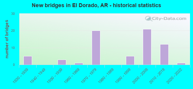
- New bridges - historical statistics
- 51930-1939
- 31950-1959
- 11960-1969
- 201970-1979
- 51990-1999
- 212000-2009
- 122010-2019
- 12020-2022
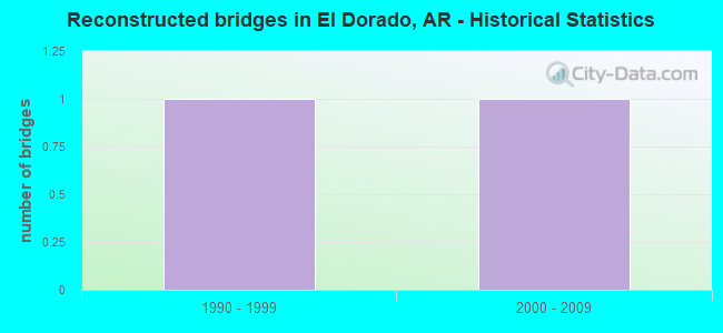
- Reconstructed bridges - Historical Statistics
- 11990-1999
- 12000-2009
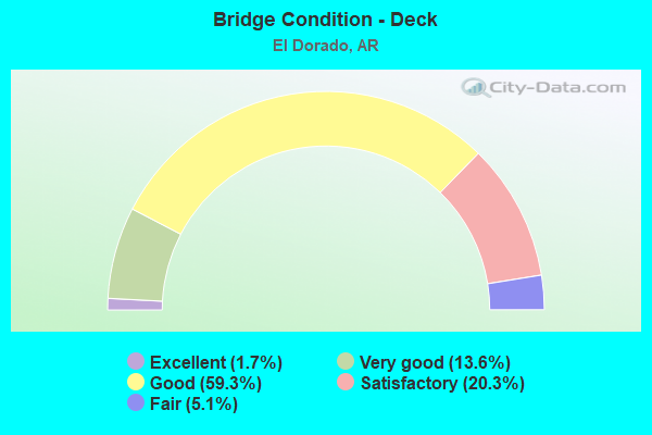
- Bridge Condition - Deck
- 1.7%Excellent
- 13.6%Very good
- 59.3%Good
- 20.3%Satisfactory
- 5.1%Fair
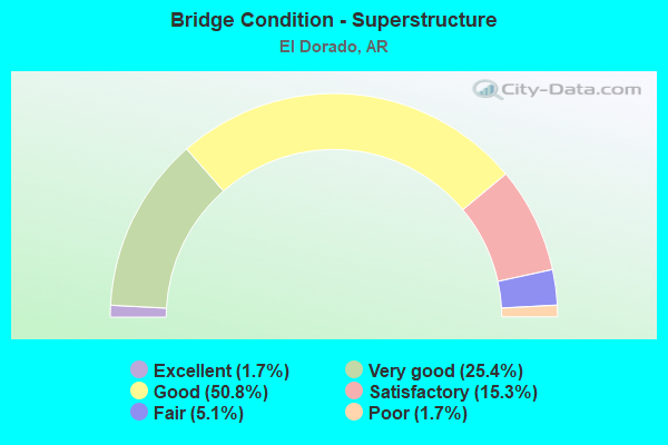
- Bridge Condition - Superstructure
- 1.7%Excellent
- 25.4%Very good
- 50.8%Good
- 15.3%Satisfactory
- 5.1%Fair
- 1.7%Poor
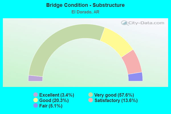
- Bridge Condition - Substructure
- 3.4%Excellent
- 57.6%Very good
- 20.3%Good
- 13.6%Satisfactory
- 5.1%Fair
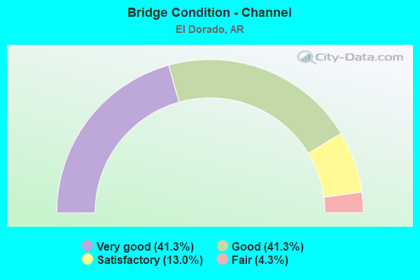
- Bridge Condition - Channel
- 41.3%Very good
- 41.3%Good
- 13.0%Satisfactory
- 4.3%Fair
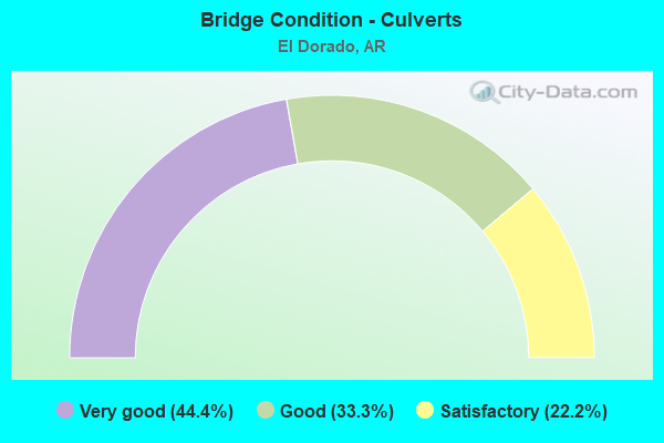
- Bridge Condition - Culverts
- 44.4%Very good
- 33.3%Good
- 22.2%Satisfactory
Find on map >> Show street view
Structure Number: 23753, Location: .41 mi W jct SH335 (Lat: 33.247589, Lng: -92.736008), Route carried "on" structure: County highway 11, Year Built: 2014, Status: Open, Structure Length: 0.94m (3.08ft), Average Daily Traffic: 1,200 (year 2018), Truck Traffic: 1%, Average Future Daily Traffic: 700 (year 2007), Features Intersected: Creek
Minimum Vertical Clearance: 30+ m (98+ ft), Kilometerpoint: 3.557, Lanes on structure: 2, Owner: County Highway Agency, Approaching Roadway Width: 7.9m (25.9ft), Material/Design: Concrete, Design/Construction: Channel Beam, Number Of Spans In Main Unit: 1, Length of Maximum Span: 9.4m (30.8ft), Curb-To-Curb Width: 7.5m (24.6ft), Out-to-Out Width: 8.0m (26.2ft)
Condition: Deck: Good, Superstructure: Good, Substructure: Very good, Channel: Very good, Operating Rating: 53.5 metric tons, Method Used To Determine Operating Rating: Load Factor (LF), Inventory Rating: 31.8 metric tons, Method Used To Determine Inventory Rating: Load Factor (LF), Structural Evaluation: Better than present minimum criteria, Deck Geometry: Meets minimum limits, Waterway Adequacy: Better than present minimum criteria, Approach Roadway Alignment: Equal to present desirable criteria, Designated Inspection Frequency: Every 24 months, Critical Feature Inspection Frequency: Every 24 months, Inspection Date: September 2020, Deck Structure Type: Concrete Precast Panels
Find on map >> Show street view
Structure Number: 2389, Location: 0.3 Mi E Jct SH 335 (Lat: 33.242331, Lng: -92.722361), Route carried "on" structure: County highway 11, Year Built: 2016, Status: Open, Structure Length: 1.89m (6.20ft), Average Daily Traffic: 1,200 (year 2018), Truck Traffic: 1%, Average Future Daily Traffic: 650 (year 2036), Features Intersected: Holmes Creek Branch
Minimum Vertical Clearance: 30+ m (98+ ft), Kilometerpoint: 2.396, Lanes on structure: 2, Owner: County Highway Agency, Approaching Roadway Width: 7.7m (25.3ft), Material/Design: Concrete, Design/Construction: Channel Beam, Number Of Spans In Main Unit: 2, Length of Maximum Span: 9.4m (30.8ft), Curb-To-Curb Width: 7.4m (24.3ft), Out-to-Out Width: 7.7m (25.3ft)
Condition: Deck: Very good, Superstructure: Very good, Substructure: Very good, Channel: Very good, Operating Rating: 54.4 metric tons, Method Used To Determine Operating Rating: Load Factor (LF), Inventory Rating: 32.7 metric tons, Method Used To Determine Inventory Rating: Load Factor (LF), Structural Evaluation: Equal to present desirable criteria, Deck Geometry: Meets minimum limits, Waterway Adequacy: Equal to present desirable criteria, Approach Roadway Alignment: Better than present minimum criteria, Designated Inspection Frequency: Every 24 months, Critical Feature Inspection Frequency: Every 24 months, Inspection Date: October 2020, Deck Structure Type: Concrete Precast Panels
Find on map >> Show street view
Structure Number: 23993, Location: 0.7 MI NW JCT US 167 (Lat: 33.134397, Lng: -92.648300), Route carried "on" structure: County highway 5, Year Built: 2018, Status: Open, Structure Length: 2.32m (7.61ft), Average Daily Traffic: 270 (year 2018), Truck Traffic: 5%, Average Future Daily Traffic: 500 (year 2037), Features Intersected: Bayou
Minimum Vertical Clearance: 30+ m (98+ ft), Kilometerpoint: 8.721, Lanes on structure: 2, Owner: County Highway Agency, Approaching Roadway Width: 7.3m (24.0ft), Material/Design: Concrete, Design/Construction: Channel Beam, Number Of Spans In Main Unit: 4, Length of Maximum Span: 5.8m (19.0ft), Curb-To-Curb Width: 6.9m (22.6ft), Out-to-Out Width: 7.5m (24.6ft)
Condition: Deck: Very good, Superstructure: Very good, Substructure: Excellent, Channel: Good, Operating Rating: 44.5 metric tons, Method Used To Determine Operating Rating: Load Factor (LF), Inventory Rating: 26.3 metric tons, Method Used To Determine Inventory Rating: Load Factor (LF), Structural Evaluation: Equal to present minimum criteria, Deck Geometry: Meets minimum limits, Waterway Adequacy: Equal to present minimum criteria, Approach Roadway Alignment: Equal to present minimum criteria, Designated Inspection Frequency: Every 24 months, Critical Feature Inspection Frequency: Every 24 months, Inspection Date: July 2020, Deck Structure Type: Concrete Precast Panels, Wearing Surface/Protective System: Wearing Surface: Monolithic Concrete
Find on map >> Show street view
Structure Number: 23994, Location: 0.8 MI NW JCT US 167 (Lat: 33.135658, Lng: -92.649578), Route carried "on" structure: County highway 5, Year Built: 2018, Status: Open, Structure Length: 0.94m (3.08ft), Average Daily Traffic: 270 (year 2018), Truck Traffic: 5%, Average Future Daily Traffic: 500 (year 2037), Features Intersected: O'Neal Ditch
Minimum Vertical Clearance: 30+ m (98+ ft), Kilometerpoint: 8.530, Lanes on structure: 2, Owner: County Highway Agency, Approaching Roadway Width: 7.3m (24.0ft), Material/Design: Concrete, Design/Construction: Channel Beam, Number Of Spans In Main Unit: 1, Length of Maximum Span: 9.4m (30.8ft), Curb-To-Curb Width: 7.3m (24.0ft), Out-to-Out Width: 7.7m (25.3ft)
Condition: Deck: Excellent, Superstructure: Excellent, Substructure: Excellent, Channel: Good, Operating Rating: 54.4 metric tons, Method Used To Determine Operating Rating: Load Factor (LF), Inventory Rating: 32.7 metric tons, Method Used To Determine Inventory Rating: Load Factor (LF), Structural Evaluation: Superior to present desirable criteria, Deck Geometry: Somewhat better than minimum adequacy, Waterway Adequacy: High priority of replacement, Approach Roadway Alignment: Equal to present desirable criteria, Designated Inspection Frequency: Every 24 months, Critical Feature Inspection Frequency: Every 24 months, Inspection Date: July 2020, Deck Structure Type: Concrete Precast Panels, Wearing Surface/Protective System: Wearing Surface: Monolithic Concrete
Find on map >> Show street view
Structure Number: 24033, Location: .10 Mi E SH 167 (Lat: 33.265208, Lng: -92.635350), Route carried "on" structure: County highway 9, Year Built: 2018, Status: Open, Structure Length: 4.72m (15.49ft), Average Daily Traffic: 170 (year 2018), Truck Traffic: 2%, Average Future Daily Traffic: 250 (year 2038), Features Intersected: Flat Creek
Minimum Vertical Clearance: 30+ m (98+ ft), Kilometerpoint: 0.161, Lanes on structure: 2, Owner: County Highway Agency, Approaching Roadway Width: 7.8m (25.6ft), Material/Design: Concrete, Design/Construction: Channel Beam, Number Of Spans In Main Unit: 5, Length of Maximum Span: 9.4m (30.8ft), Curb-To-Curb Width: 7.4m (24.3ft), Out-to-Out Width: 7.7m (25.3ft)
Condition: Deck: Good, Superstructure: Good, Substructure: Very good, Channel: Satisfactory, Operating Rating: 54.4 metric tons, Method Used To Determine Operating Rating: Load Factor (LF), Inventory Rating: 32.7 metric tons, Method Used To Determine Inventory Rating: Load Factor (LF), Structural Evaluation: Better than present minimum criteria, Deck Geometry: Somewhat better than minimum adequacy, Waterway Adequacy: Equal to present minimum criteria, Approach Roadway Alignment: Better than present minimum criteria, Designated Inspection Frequency: Every 24 months, Critical Feature Inspection Frequency: Every 24 months, Inspection Date: March 2021, Deck Structure Type: Concrete Precast Panels, Wearing Surface/Protective System: Wearing Surface: Monolithic Concrete
Find on map >> Show street view
Structure Number: A5695, Location: .2 MI W OF JCT 82B (Lat: 33.190150, Lng: -92.621869), Route carried "on" structure: US 82, Year Built: 1978, Status: Open, Structure Length: 3.81m (12.50ft), Average Daily Traffic: 3,500 (year 2018), Truck Traffic: 1%, Average Future Daily Traffic: 4,223 (year 2028), Design Load: HS 20, Features Intersected: BOGGY BAYOU
Minimum Vertical Clearance: 30+ m (98+ ft), Kilometerpoint: 1.320, Lanes on structure: 2, Base Highway Network: Yes, Owner: State Highway Agency, Approaching Roadway Width: 12.2m (40.0ft), Material/Design: Concrete, Design/Construction: Slab, Number Of Spans In Main Unit: 5, Length of Maximum Span: 7.6m (24.9ft), Curb-To-Curb Width: 12.2m (40.0ft), Out-to-Out Width: 13.0m (42.7ft)
Condition: Deck: Satisfactory, Superstructure: Satisfactory, Substructure: Good, Channel: Good, Operating Rating: 54.4 metric tons, Method Used To Determine Operating Rating: Load Factor (LF), Inventory Rating: 32.7 metric tons, Method Used To Determine Inventory Rating: Load Factor (LF), Structural Evaluation: Equal to present minimum criteria, Deck Geometry: Better than present minimum criteria, Waterway Adequacy: Better than present minimum criteria, Approach Roadway Alignment: Equal to present desirable criteria, Designated Inspection Frequency: Every 24 months, Critical Feature Inspection Frequency: Every 24 months, Inspection Date: Febuary 2022, Deck Structure Type: Concrete Cast-file-Place, Wearing Surface/Protective System: Wearing Surface: Monolithic Concrete
Find on map >> Show street view
Structure Number: A5696, Location: @ JCT US 82 & US 167 (Lat: 33.186400, Lng: -92.635369), Route carried "on" structure: US 82, Year Built: 1978, Status: Open, Structure Length: 6.59m (21.62ft), Average Daily Traffic: 5,000 (year 2018), Truck Traffic: 16%, Average Future Daily Traffic: 11,400 (year 2038), Design Load: HS 20, Features Intersected: US 167-SEC 1
Minimum Vertical Clearance: 30+ m (98+ ft), Kilometerpoint: 35.027, Lanes on structure: 2, Lanes under structure: 4, Base Highway Network: Yes, Owner: State Highway Agency, Approaching Roadway Width: 13.1m (43.0ft), Skew: 3 degrees, Material/Design: Steel continuous, Design/Construction: Stringer/Multi-beam, Number Of Spans In Main Unit: 2, Length of Maximum Span: 32.6m (107.0ft), Curb-To-Curb Width: 12.2m (40.0ft), Out-to-Out Width: 13.0m (42.7ft)
Condition: Deck: Good, Superstructure: Good, Substructure: Very good, Operating Rating: 45.4 metric tons, Method Used To Determine Operating Rating: Load Factor (LF), Inventory Rating: 27.2 metric tons, Method Used To Determine Inventory Rating: Load Factor (LF), Structural Evaluation: Equal to present minimum criteria, Deck Geometry: Better than present minimum criteria, Underclear: Somewhat better than minimum adequacy, Approach Roadway Alignment: Equal to present desirable criteria, Designated Inspection Frequency: Every 24 months, Critical Feature Inspection Frequency: Every 24 months, Inspection Date: June 2020, Deck Structure Type: Concrete Cast-file-Place, Wearing Surface/Protective System: Wearing Surface: Monolithic Concrete
Find on map >> Show street view
Structure Number: A5788, Location: 2.7 MI E JCT US 82 & 82B (Lat: 33.186831, Lng: -92.671750), Route carried "on" structure: US 82, Year Built: 1979, Status: Open, Structure Length: 6.28m (20.60ft), Average Daily Traffic: 4,860 (year 2018), Truck Traffic: 15%, Average Future Daily Traffic: 5,937 (year 2028), Design Load: HS 20, Features Intersected: SOUTHWEST AVE.
Minimum Vertical Clearance: 30+ m (98+ ft), Kilometerpoint: 31.608, Lanes on structure: 2, Lanes under structure: 2, Base Highway Network: Yes, Owner: State Highway Agency, Approaching Roadway Width: 12.2m (40.0ft), Material/Design: Steel continuous, Design/Construction: Stringer/Multi-beam, Number Of Spans In Main Unit: 3, Length of Maximum Span: 24.4m (80.1ft), Curb-To-Curb Width: 12.2m (40.0ft), Out-to-Out Width: 13.0m (42.7ft)
Condition: Deck: Good, Superstructure: Satisfactory, Substructure: Very good, Operating Rating: 54.4 metric tons, Method Used To Determine Operating Rating: Load Factor (LF), Inventory Rating: 32.7 metric tons, Method Used To Determine Inventory Rating: Load Factor (LF), Structural Evaluation: Equal to present minimum criteria, Deck Geometry: Better than present minimum criteria, Underclear: Better than present minimum criteria, Approach Roadway Alignment: Equal to present desirable criteria, Designated Inspection Frequency: Every 24 months, Critical Feature Inspection Frequency: Every 24 months, Inspection Date: March 2021, Deck Structure Type: Concrete Cast-file-Place, Wearing Surface/Protective System: Wearing Surface: Monolithic Concrete
Find on map >> Show street view
Structure Number: A5789, Location: 2.5 MI E JCT 82 & 82B (Lat: 33.187550, Lng: -92.674958), Route carried "on" structure: US 82, Year Built: 1979, Status: Open, Structure Length: 10.01m (32.84ft), Average Daily Traffic: 4,700 (year 2018), Truck Traffic: 15%, Average Future Daily Traffic: 10,700 (year 2038), Design Load: HS 20, Features Intersected: Ouachita Valley RR
Minimum Vertical Clearance: 30+ m (98+ ft), Kilometerpoint: 31.295, Lanes on structure: 3, Base Highway Network: Yes, Owner: State Highway Agency, Approaching Roadway Width: 12.2m (40.0ft), Skew: 3 degrees, Material/Design: Steel, Design/Construction: Stringer/Multi-beam, Number Of Spans In Main Unit: 4, Length of Maximum Span: 27.4m (89.9ft), Curb-To-Curb Width: 12.2m (40.0ft), Out-to-Out Width: 14.2m (46.6ft)
Condition: Deck: Good, Superstructure: Good, Substructure: Satisfactory, Operating Rating: 54.4 metric tons, Method Used To Determine Operating Rating: Load Factor (LF), Inventory Rating: 32.7 metric tons, Method Used To Determine Inventory Rating: Load Factor (LF), Structural Evaluation: Equal to present minimum criteria, Deck Geometry: High priority of corrective action, Underclear: Superior to present desirable criteria, Approach Roadway Alignment: Equal to present desirable criteria, Designated Inspection Frequency: Every 24 months, Critical Feature Inspection Frequency: Every 24 months, Inspection Date: June 2020, Deck Structure Type: Concrete Cast-file-Place, Wearing Surface/Protective System: Wearing Surface: Monolithic Concrete
Find on map >> Show street view
Structure Number: A5791, Location: 1.6 MI E JCT US 82 & 82B (Lat: 33.191339, Lng: -92.689739), Route carried "on" structure: US 82, Year Built: 1979, Status: Open, Structure Length: 35.02m (114.90ft), Average Daily Traffic: 4,700 (year 2018), Truck Traffic: 15%, Average Future Daily Traffic: 4,900 (year 2038), Design Load: HS 20, Features Intersected: WESSON RR
Minimum Vertical Clearance: 30+ m (98+ ft), Kilometerpoint: 29.847, Lanes on structure: 2, Base Highway Network: Yes, Owner: State Highway Agency, Approaching Roadway Width: 12.2m (40.0ft), Material/Design: Steel, Design/Construction: Stringer/Multi-beam, Number Of Spans In Main Unit: 21, Length of Maximum Span: 36.0m (118.1ft), Curb-To-Curb Width: 12.2m (40.0ft), Out-to-Out Width: 13.1m (43.0ft)
Condition: Deck: Satisfactory, Superstructure: Very good, Substructure: Satisfactory, Operating Rating: 54.4 metric tons, Method Used To Determine Operating Rating: Load Factor (LF), Inventory Rating: 32.7 metric tons, Method Used To Determine Inventory Rating: Load Factor (LF), Structural Evaluation: Equal to present minimum criteria, Deck Geometry: Better than present minimum criteria, Underclear: Superior to present desirable criteria, Approach Roadway Alignment: Superior to present desirable criteria, Designated Inspection Frequency: Every 24 months, Critical Feature Inspection Frequency: Every 24 months, Other Special Inspection Frequency: Every 24 months, Inspection Date: July 2021, Other Special Inspection Date: May 2020, Deck Structure Type: Concrete Cast-file-Place, Wearing Surface/Protective System: Wearing Surface: Monolithic Concrete
Find on map >> Show street view
Structure Number: A7074, Location: Jct. US 167 & 82B (Lat: 33.198069, Lng: -92.641281), Route carried "on" structure: US 167, Year Built: 2011, Status: Open, Structure Length: 4.50m (14.76ft), Average Daily Traffic: 6,000 (year 2018), Truck Traffic: 18%, Average Future Daily Traffic: 16,953 (year 2026), Design Load: HS 20, Features Intersected: US 82B Sec. 5B
Minimum Vertical Clearance: 30+ m (98+ ft), Kilometerpoint: 24.108, Lanes on structure: 1, Lanes under structure: 6, Owner: State Highway Agency, Approaching Roadway Width: 12.2m (40.0ft), Skew: 3 degrees, Material/Design: Steel, Design/Construction: Stringer/Multi-beam, Number Of Spans In Main Unit: 1, Length of Maximum Span: 44.2m (145.0ft), Curb-To-Curb Width: 12.2m (40.0ft), Out-to-Out Width: 13.1m (43.0ft)
Condition: Deck: Good, Superstructure: Very good, Substructure: Very good, Operating Rating: 52.6 metric tons, Method Used To Determine Operating Rating: Load Factor (LF), Inventory Rating: 31.8 metric tons, Method Used To Determine Inventory Rating: Load Factor (LF), Structural Evaluation: Better than present minimum criteria, Deck Geometry: Somewhat better than minimum adequacy, Underclear: Equal to present minimum criteria, Approach Roadway Alignment: Equal to present desirable criteria, Designated Inspection Frequency: Every 24 months, Critical Feature Inspection Frequency: Every 24 months, Inspection Date: July 2019, Deck Structure Type: Concrete Cast-file-Place
Find on map >> Show street view
Structure Number: A7075, Location: .50 Mi S Jct US 63 (Lat: 33.202919, Lng: -92.641361), Route carried "on" structure: US 167, Year Built: 2011, Status: Open, Structure Length: 9.85m (32.32ft), Average Daily Traffic: 6,000 (year 2018), Truck Traffic: 18%, Average Future Daily Traffic: 16,953 (year 2026), Design Load: HS 20, Features Intersected: Memory Lane,Cook St,RR
Minimum Vertical Clearance: 30+ m (98+ ft), Kilometerpoint: 24.671, Lanes on structure: 2, Lanes under structure: 4, Base Highway Network: Yes, Owner: State Highway Agency, Approaching Roadway Width: 12.2m (40.0ft), Material/Design: Steel continuous, Design/Construction: Stringer/Multi-beam, Number Of Spans In Main Unit: 3, Length of Maximum Span: 37.5m (123.0ft), Curb-To-Curb Width: 12.2m (40.0ft), Out-to-Out Width: 13.1m (43.0ft)
Condition: Deck: Satisfactory, Superstructure: Very good, Substructure: Very good, Operating Rating: 54.4 metric tons, Method Used To Determine Operating Rating: Load Factor (LF), Inventory Rating: 32.7 metric tons, Method Used To Determine Inventory Rating: Load Factor (LF), Structural Evaluation: Equal to present desirable criteria, Deck Geometry: Better than present minimum criteria, Underclear: Equal to present minimum criteria, Approach Roadway Alignment: Equal to present desirable criteria, Designated Inspection Frequency: Every 24 months, Critical Feature Inspection Frequency: Every 24 months, Inspection Date: July 2019, Deck Structure Type: Concrete Cast-file-Place, Wearing Surface/Protective System: Wearing Surface: Monolithic Concrete, Deck Protection: Epoxy Coated Reinforcing
Find on map >> Show street view
Structure Number: B5695, Location: .2 MI W OF JCT US 82B (Lat: 33.189978, Lng: -92.621778), Route carried "on" structure: US 82, Year Built: 1978, Status: Open, Structure Length: 3.81m (12.50ft), Average Daily Traffic: 3,500 (year 2018), Truck Traffic: 16%, Average Future Daily Traffic: 8,000 (year 2038), Design Load: HS 20, Features Intersected: BOGGY BAYOU
Minimum Vertical Clearance: 30+ m (98+ ft), Kilometerpoint: 1.320, Lanes on structure: 2, Base Highway Network: Yes, Owner: State Highway Agency, Approaching Roadway Width: 12.2m (40.0ft), Material/Design: Concrete, Design/Construction: Slab, Number Of Spans In Main Unit: 5, Length of Maximum Span: 7.6m (24.9ft), Curb-To-Curb Width: 12.2m (40.0ft), Out-to-Out Width: 13.0m (42.7ft)
Condition: Deck: Good, Superstructure: Good, Substructure: Good, Channel: Very good, Operating Rating: 54.4 metric tons, Method Used To Determine Operating Rating: Load Factor (LF), Inventory Rating: 32.7 metric tons, Method Used To Determine Inventory Rating: Load Factor (LF), Structural Evaluation: Better than present minimum criteria, Deck Geometry: Better than present minimum criteria, Waterway Adequacy: Equal to present desirable criteria, Approach Roadway Alignment: Equal to present desirable criteria, Designated Inspection Frequency: Every 24 months, Critical Feature Inspection Frequency: Every 24 months, Inspection Date: March 2021, Deck Structure Type: Concrete Cast-file-Place, Wearing Surface/Protective System: Wearing Surface: Monolithic Concrete
Find on map >> Show street view
Structure Number: B5696, Location: @ JCT US 82 & US 167 (Lat: 33.186589, Lng: -92.635369), Route carried "on" structure: US 82, Year Built: 1978, Status: Open, Structure Length: 6.59m (21.62ft), Average Daily Traffic: 5,000 (year 2018), Truck Traffic: 1%, Average Future Daily Traffic: 5,937 (year 2028), Design Load: HS 20, Features Intersected: US 167-SEC 1
Minimum Vertical Clearance: 30+ m (98+ ft), Kilometerpoint: 35.027, Lanes on structure: 2, Lanes under structure: 4, Base Highway Network: Yes, Owner: State Highway Agency, Approaching Roadway Width: 13.1m (43.0ft), Skew: 3 degrees, Material/Design: Steel continuous, Design/Construction: Stringer/Multi-beam, Number Of Spans In Main Unit: 2, Length of Maximum Span: 32.6m (107.0ft), Curb-To-Curb Width: 12.2m (40.0ft), Out-to-Out Width: 13.0m (42.7ft)
Condition: Deck: Good, Superstructure: Good, Substructure: Very good, Operating Rating: 54.4 metric tons, Method Used To Determine Operating Rating: Load Factor (LF), Inventory Rating: 27.2 metric tons, Method Used To Determine Inventory Rating: Load Factor (LF), Structural Evaluation: Equal to present minimum criteria, Deck Geometry: Better than present minimum criteria, Underclear: Equal to present minimum criteria, Approach Roadway Alignment: Equal to present desirable criteria, Designated Inspection Frequency: Every 24 months, Critical Feature Inspection Frequency: Every 24 months, Inspection Date: June 2020, Deck Structure Type: Concrete Cast-file-Place, Wearing Surface/Protective System: Wearing Surface: Monolithic Concrete
Find on map >> Show street view
Structure Number: B5788, Location: 2.7 MI E JCT US 82 & 82B (Lat: 33.187000, Lng: -92.671689), Route carried "on" structure: US 82, Year Built: 1979, Status: Open, Structure Length: 6.28m (20.60ft), Average Daily Traffic: 4,860 (year 2018), Truck Traffic: 1%, Average Future Daily Traffic: 5,937 (year 2028), Design Load: HS 20, Features Intersected: SOUTHWEST AVE.
Minimum Vertical Clearance: 30+ m (98+ ft), Kilometerpoint: 31.601, Lanes on structure: 2, Lanes under structure: 2, Base Highway Network: Yes, Owner: State Highway Agency, Approaching Roadway Width: 12.2m (40.0ft), Material/Design: Steel continuous, Design/Construction: Stringer/Multi-beam, Number Of Spans In Main Unit: 3, Length of Maximum Span: 24.4m (80.1ft), Curb-To-Curb Width: 12.2m (40.0ft), Out-to-Out Width: 13.0m (42.7ft)
Condition: Deck: Good, Superstructure: Satisfactory, Substructure: Very good, Operating Rating: 54.4 metric tons, Method Used To Determine Operating Rating: Load Factor (LF), Inventory Rating: 32.7 metric tons, Method Used To Determine Inventory Rating: Load Factor (LF), Structural Evaluation: Equal to present minimum criteria, Deck Geometry: Better than present minimum criteria, Underclear: Better than present minimum criteria, Approach Roadway Alignment: Equal to present desirable criteria, Designated Inspection Frequency: Every 24 months, Critical Feature Inspection Frequency: Every 24 months, Inspection Date: March 2021, Deck Structure Type: Concrete Cast-file-Place, Wearing Surface/Protective System: Wearing Surface: Monolithic Concrete
Find on map >> Show street view
Structure Number: B5789, Location: 2.5 MI E JCT US 82 & 82B (Lat: 33.187750, Lng: -92.675028), Route carried "on" structure: US 82, Year Built: 1979, Status: Open, Structure Length: 10.00m (32.81ft), Average Daily Traffic: 4,700 (year 2018), Truck Traffic: 1%, Average Future Daily Traffic: 5,570 (year 2028), Design Load: HS 20, Features Intersected: ouachita Valley RR
Minimum Vertical Clearance: 30+ m (98+ ft), Kilometerpoint: 31.295, Lanes on structure: 3, Base Highway Network: Yes, Owner: State Highway Agency, Approaching Roadway Width: 14.6m (47.9ft), Skew: 3 degrees, Material/Design: Steel, Design/Construction: Stringer/Multi-beam, Number Of Spans In Main Unit: 5, Length of Maximum Span: 27.4m (89.9ft), Curb-To-Curb Width: 14.6m (47.9ft), Out-to-Out Width: 15.5m (50.9ft)
Condition: Deck: Good, Superstructure: Good, Substructure: Satisfactory, Operating Rating: 54.4 metric tons, Method Used To Determine Operating Rating: Load Factor (LF), Inventory Rating: 32.7 metric tons, Method Used To Determine Inventory Rating: Load Factor (LF), Structural Evaluation: Equal to present minimum criteria, Deck Geometry: Meets minimum limits, Underclear: Superior to present desirable criteria, Approach Roadway Alignment: Superior to present desirable criteria, Designated Inspection Frequency: Every 24 months, Critical Feature Inspection Frequency: Every 24 months, Inspection Date: June 2020, Deck Structure Type: Concrete Cast-file-Place, Wearing Surface/Protective System: Wearing Surface: Monolithic Concrete
Find on map >> Show street view
Structure Number: B5791, Location: 1.6 MI E JCT US 82 & 82B (Lat: 33.191500, Lng: -92.689633), Route carried "on" structure: US 82, Year Built: 1979, Status: Open, Structure Length: 34.66m (113.71ft), Average Daily Traffic: 4,700 (year 2018), Truck Traffic: 1%, Average Future Daily Traffic: 5,570 (year 2028), Design Load: HS 20, Features Intersected: WESSON RR
Minimum Vertical Clearance: 30+ m (98+ ft), Kilometerpoint: 29.847, Lanes on structure: 2, Base Highway Network: Yes, Owner: State Highway Agency, Approaching Roadway Width: 12.2m (40.0ft), Material/Design: Steel, Design/Construction: Stringer/Multi-beam, Number Of Spans In Main Unit: 21, Length of Maximum Span: 41.1m (134.8ft), Curb-To-Curb Width: 12.2m (40.0ft), Out-to-Out Width: 13.1m (43.0ft)
Condition: Deck: Satisfactory, Superstructure: Good, Substructure: Good, Operating Rating: 54.4 metric tons, Method Used To Determine Operating Rating: Load Factor (LF), Inventory Rating: 32.7 metric tons, Method Used To Determine Inventory Rating: Load Factor (LF), Structural Evaluation: Better than present minimum criteria, Deck Geometry: Better than present minimum criteria, Underclear: Equal to present desirable criteria, Approach Roadway Alignment: Equal to present desirable criteria, Designated Inspection Frequency: Every 24 months, Critical Feature Inspection Frequency: Every 24 months, Inspection Date: June 2020, Deck Structure Type: Concrete Cast-file-Place, Wearing Surface/Protective System: Wearing Surface: Monolithic Concrete
Find on map >> Show street view
Structure Number: B7074, Location: JCT 167 & 82B (Lat: 33.197969, Lng: -92.641139), Route carried "on" structure: US 167, Year Built: 2010, Status: Open, Structure Length: 4.50m (14.76ft), Average Daily Traffic: 6,000 (year 2018), Truck Traffic: 16%, Average Future Daily Traffic: 13,700 (year 2038), Design Load: HS 20, Features Intersected: US 82-B Sec.-5B
Minimum Vertical Clearance: 30+ m (98+ ft), Kilometerpoint: 24.108, Lanes on structure: 2, Lanes under structure: 6, Owner: State Highway Agency, Approaching Roadway Width: 12.2m (40.0ft), Skew: 3 degrees, Material/Design: Steel, Design/Construction: Stringer/Multi-beam, Number Of Spans In Main Unit: 1, Length of Maximum Span: 44.2m (145.0ft), Curb-To-Curb Width: 12.2m (40.0ft), Out-to-Out Width: 13.1m (43.0ft)
Condition: Deck: Good, Superstructure: Very good, Substructure: Very good, Operating Rating: 52.6 metric tons, Method Used To Determine Operating Rating: Load Factor (LF), Inventory Rating: 31.8 metric tons, Method Used To Determine Inventory Rating: Load Factor (LF), Structural Evaluation: Better than present minimum criteria, Deck Geometry: Better than present minimum criteria, Underclear: Equal to present minimum criteria, Approach Roadway Alignment: Equal to present desirable criteria, Designated Inspection Frequency: Every 24 months, Critical Feature Inspection Frequency: Every 24 months, Inspection Date: July 2020, Deck Structure Type: Concrete Cast-file-Place
Find on map >> Show street view
Structure Number: B7075, Location: .50 mi.S jct. US 63 (Lat: 33.202919, Lng: -92.641211), Route carried "on" structure: US 167, Year Built: 2009, Status: Open, Structure Length: 9.85m (32.32ft), Average Daily Traffic: 6,000 (year 2018), Truck Traffic: 10%, Average Future Daily Traffic: 13,700 (year 2038), Design Load: HS 20, Features Intersected: Memory Lane.CookSt/RR
Minimum Vertical Clearance: 30.17m (98.98ft), Kilometerpoint: 24.671, Lanes on structure: 1, Lanes under structure: 4, Base Highway Network: Yes, Owner: State Highway Agency, Approaching Roadway Width: 12.2m (40.0ft), Material/Design: Steel continuous, Design/Construction: Stringer/Multi-beam, Number Of Spans In Main Unit: 3, Length of Maximum Span: 37.5m (123.0ft), Curb-To-Curb Width: 12.2m (40.0ft), Out-to-Out Width: 12.2m (40.0ft)
Condition: Deck: Satisfactory, Superstructure: Very good, Substructure: Very good, Operating Rating: 54.4 metric tons, Method Used To Determine Operating Rating: Load Factor (LF), Inventory Rating: 32.7 metric tons, Method Used To Determine Inventory Rating: Load Factor (LF), Structural Evaluation: Equal to present desirable criteria, Deck Geometry: Somewhat better than minimum adequacy, Underclear: Somewhat better than minimum adequacy, Approach Roadway Alignment: Equal to present desirable criteria, Designated Inspection Frequency: Every 24 months, Critical Feature Inspection Frequency: Every 24 months, Inspection Date: August 2021, Deck Structure Type: Concrete Cast-file-Place, Wearing Surface/Protective System: Wearing Surface: Monolithic Concrete
Find on map >> Show street view
Structure Number: B7085, Location: 1.03 mi. NW Jct. US 167 (Lat: 33.264947, Lng: -92.651389), Route carried "on" structure: State highway 7, Year Built: 2010, Status: Open, Structure Length: 4.27m (14.01ft), Average Daily Traffic: 5,800 (year 2018), Truck Traffic: 18%, Average Future Daily Traffic: 6,600 (year 2038), Design Load: HS 20, Features Intersected: Mill Creek
Minimum Vertical Clearance: 30+ m (98+ ft), Kilometerpoint: 1.320, Lanes on structure: 2, Owner: State Highway Agency, Approaching Roadway Width: 7.3m (24.0ft), Material/Design: Concrete, Design/Construction: Tee Beam, Number Of Spans In Main Unit: 5, Length of Maximum Span: 8.5m (27.9ft), Curb-To-Curb Width: 12.2m (40.0ft), Out-to-Out Width: 13.2m (43.3ft)
Condition: Deck: Good, Superstructure: Good, Substructure: Good, Channel: Good, Operating Rating: 54.4 metric tons, Method Used To Determine Operating Rating: Load Factor (LF), Inventory Rating: 32.7 metric tons, Method Used To Determine Inventory Rating: Load Factor (LF), Structural Evaluation: Better than present minimum criteria, Deck Geometry: Somewhat better than minimum adequacy, Waterway Adequacy: Equal to present desirable criteria, Approach Roadway Alignment: Equal to present desirable criteria, Designated Inspection Frequency: Every 24 months, Critical Feature Inspection Frequency: Every 24 months, Inspection Date: December 2020, Deck Structure Type: Concrete Cast-file-Place, Wearing Surface/Protective System: Wearing Surface: Monolithic Concrete
Find on map >> Show street view
Structure Number: M0406, Location: 0.4 MI SW OF JCT US &2 (Lat: 33.188319, Lng: -92.696978), Route carried "on" structure: State highway 15, Year Built: 1931, Status: Open, Structure Length: 0.82m (2.69ft), Average Daily Traffic: 7,200 (year 2018), Truck Traffic: 1%, Average Future Daily Traffic: 8,692 (year 2028), Design Load: H 15, Features Intersected: CREEK
Minimum Vertical Clearance: 30+ m (98+ ft), Kilometerpoint: 33.144, Lanes on structure: 2, Owner: State Highway Agency, Approaching Roadway Width: 10.4m (34.1ft), Material/Design: Concrete, Design/Construction: Culvert, Number Of Spans In Main Unit: 3, Length of Maximum Span: 2.4m (7.9ft)
Condition: Channel: Good, Culverts: Good, Operating Rating: 47.2 metric tons, Method Used To Determine Operating Rating: Load Factor (LF), Inventory Rating: 28.1 metric tons, Method Used To Determine Inventory Rating: Load Factor (LF), Structural Evaluation: Better than present minimum criteria, Waterway Adequacy: Better than present minimum criteria, Approach Roadway Alignment: Equal to present minimum criteria, Designated Inspection Frequency: Every 24 months, Critical Feature Inspection Frequency: Every 24 months, Inspection Date: March 2020
Find on map >> Show street view
Structure Number: M0407, Location: 0.42 MI E OF US 167 (Lat: 33.215258, Lng: -92.627250), Route carried "on" structure: US 63, Year Built: 1930, Year Reconstructed: 1999, Status: Open, Structure Length: 0.82m (2.69ft), Average Daily Traffic: 7,600 (year 2018), Truck Traffic: 4%, Average Future Daily Traffic: 9,793 (year 2028), Design Load: H 15, Features Intersected: CREEK
Minimum Vertical Clearance: 30+ m (98+ ft), Kilometerpoint: 27.826, Lanes on structure: 2, Owner: State Highway Agency, Approaching Roadway Width: 17.4m (57.1ft), Material/Design: Concrete, Design/Construction: Culvert, Number Of Spans In Main Unit: 3, Length of Maximum Span: 2.4m (7.9ft)
Condition: Channel: Good, Culverts: Very good, Operating Rating: 47.2 metric tons, Method Used To Determine Operating Rating: Load Factor (LF), Inventory Rating: 28.1 metric tons, Method Used To Determine Inventory Rating: Load Factor (LF), Structural Evaluation: Better than present minimum criteria, Waterway Adequacy: Better than present minimum criteria, Approach Roadway Alignment: Better than present minimum criteria, Designated Inspection Frequency: Every 24 months, Critical Feature Inspection Frequency: Every 24 months, Inspection Date: March 2020
Find on map >> Show street view
Structure Number: X0472, Location: 2.43 MI W JCT US 167 (Lat: 33.188178, Lng: -92.677808), Route carried "on" structure: US 82, Year Built: 1979, Status: Open, Structure Length: 1.22m (4.00ft), Average Daily Traffic: 9,400 (year 2018), Truck Traffic: 15%, Average Future Daily Traffic: 10,700 (year 2038), Design Load: H 20, Features Intersected: CREEK
Minimum Vertical Clearance: 30+ m (98+ ft), Kilometerpoint: 31.150, Lanes on structure: 4, Base Highway Network: Yes, Owner: State Highway Agency, Approaching Roadway Width: 23.2m (76.1ft), Skew: 4 degrees, Material/Design: Concrete, Design/Construction: Culvert, Number Of Spans In Main Unit: 4, Length of Maximum Span: 3.0m (9.8ft)
Condition: Channel: Good, Culverts: Satisfactory, Operating Rating: 39.0 metric tons, Method Used To Determine Operating Rating: Load Factor (LF), Inventory Rating: 23.6 metric tons, Method Used To Determine Inventory Rating: Load Factor (LF), Structural Evaluation: Somewhat better than minimum adequacy, Waterway Adequacy: Equal to present desirable criteria, Approach Roadway Alignment: Equal to present desirable criteria, Designated Inspection Frequency: Every 24 months, Critical Feature Inspection Frequency: Every 24 months, Inspection Date: May 2020
Find on map >> Show street view
Structure Number: X0473, Location: 0.79 MI W JCT US 167 (Lat: 33.185419, Lng: -92.648550), Route carried "on" structure: US 82, Year Built: 1979, Status: Open, Structure Length: 0.94m (3.08ft), Average Daily Traffic: 10,000 (year 2018), Truck Traffic: 16%, Average Future Daily Traffic: 11,400 (year 2038), Design Load: H 20, Features Intersected: CREEK
Minimum Vertical Clearance: 30+ m (98+ ft), Kilometerpoint: 33.790, Lanes on structure: 4, Base Highway Network: Yes, Owner: State Highway Agency, Approaching Roadway Width: 23.2m (76.1ft), Material/Design: Concrete, Design/Construction: Culvert, Number Of Spans In Main Unit: 3, Length of Maximum Span: 3.0m (9.8ft)
Condition: Channel: Good, Culverts: Good, Operating Rating: 42.6 metric tons, Method Used To Determine Operating Rating: Load Factor (LF), Inventory Rating: 25.4 metric tons, Method Used To Determine Inventory Rating: Load Factor (LF), Structural Evaluation: Equal to present minimum criteria, Waterway Adequacy: Equal to present desirable criteria, Approach Roadway Alignment: Equal to present desirable criteria, Designated Inspection Frequency: Every 24 months, Critical Feature Inspection Frequency: Every 24 months, Inspection Date: May 2020
Find on map >> Show street view
Structure Number: X107, Location: 3.3 mi E of us 167 (Lat: 33.174739, Lng: -92.585278), Route carried "on" structure: US 82, Year Built: 2003, Status: Open, Structure Length: 0.67m (2.20ft), Average Daily Traffic: 4,700 (year 2018), Truck Traffic: 19%, Average Future Daily Traffic: 4,897 (year 2028), Design Load: H 20, Features Intersected: Creek
Minimum Vertical Clearance: 30+ m (98+ ft), Kilometerpoint: 5.311, Lanes on structure: 2, Base Highway Network: Yes, Owner: State Highway Agency, Approaching Roadway Width: 14.9m (48.9ft), Material/Design: Concrete, Design/Construction: Culvert, Number Of Spans In Main Unit: 3, Length of Maximum Span: 2.1m (6.9ft)
Condition: Channel: Very good, Culverts: Good, Operating Rating: 27.2 metric tons, Method Used To Determine Operating Rating: Load Factor (LF), Inventory Rating: 16.3 metric tons, Method Used To Determine Inventory Rating: Load Factor (LF), Structural Evaluation: Meets minimum limits, Waterway Adequacy: Equal to present desirable criteria, Approach Roadway Alignment: Equal to present desirable criteria, Designated Inspection Frequency: Every 24 months, Critical Feature Inspection Frequency: Every 24 months, Inspection Date: May 2021
Find on map >> Show street view
Structure Number: X1321, Location: 3.42 mi n jct. US 82 (Lat: 33.244431, Lng: -92.636161), Route carried "on" structure: US 167, Year Built: 2007, Status: Open, Structure Length: 0.76m (2.49ft), Average Daily Traffic: 9,800 (year 2018), Truck Traffic: 20%, Average Future Daily Traffic: 11,262 (year 2026), Design Load: HS 20, Features Intersected: Creek
Minimum Vertical Clearance: 30+ m (98+ ft), Kilometerpoint: 29.612, Lanes on structure: 2, Base Highway Network: Yes, Owner: State Highway Agency, Approaching Roadway Width: 7.9m (25.9ft), Material/Design: Concrete, Design/Construction: Culvert, Number Of Spans In Main Unit: 2, Length of Maximum Span: 3.7m (12.1ft)
Condition: Channel: Satisfactory, Culverts: Satisfactory, Operating Rating: 39.0 metric tons, Method Used To Determine Operating Rating: Load Factor (LF), Inventory Rating: 23.6 metric tons, Method Used To Determine Inventory Rating: Load Factor (LF), Structural Evaluation: Somewhat better than minimum adequacy, Waterway Adequacy: Equal to present desirable criteria, Approach Roadway Alignment: Better than present minimum criteria, Designated Inspection Frequency: Every 24 months, Critical Feature Inspection Frequency: Every 24 months, Inspection Date: December 2021
Find on map >> Show street view
Structure Number: X1592, Location: 3.0 MI N JCT US 82 (Lat: 33.253347, Lng: -92.724769), Route carried "on" structure: State highway 335, Year Built: 2020, Status: Open, Structure Length: 1.08m (3.54ft), Average Daily Traffic: 1,500 (year 2016), Truck Traffic: 11%, Average Future Daily Traffic: 1,900 (year 2036), Design Load: HL 93, Features Intersected: Creek
Minimum Vertical Clearance: 30+ m (98+ ft), Kilometerpoint: 5.456, Lanes on structure: 2, Owner: State Highway Agency, Approaching Roadway Width: 7.3m (24.0ft), Material/Design: Concrete, Design/Construction: Culvert, Number Of Spans In Main Unit: 3, Length of Maximum Span: 3.0m (9.8ft), Curb-To-Curb Width: 18.9m (62.0ft), Out-to-Out Width: 20.5m (67.3ft)
Condition: Channel: Good, Culverts: Very good, Operating Rating: 39.9 metric tons, Method Used To Determine Operating Rating: Load and Resistance Factor (LRFR), Inventory Rating: 30.8 metric tons, Method Used To Determine Inventory Rating: Load and Resistance Factor (LRFR), Structural Evaluation: Better than present minimum criteria, Deck Geometry: Superior to present desirable criteria, Waterway Adequacy: Equal to present minimum criteria, Approach Roadway Alignment: Better than present minimum criteria, Designated Inspection Frequency: Every 24 months, Critical Feature Inspection Frequency: Every 24 months, Inspection Date: November 2020
Find on map >> Show street view
Structure Number: 639, Location: 1.28 MI E JCT US 167B (Lat: 33.203289, Lng: -92.645553), Route carried "under" structure: Business US 82, Structure Length: 0. m, Average Daily Traffic: 10,000 (year 2014), Truck Traffic: 1%, Features Intersected: US 82-SEC 5B, Facility Carried by Structure: UNION PACIFIC RR
Minimum Vertical Clearance: 4.93m (16.17ft), Kilometerpoint: 5.760, Length of Maximum Span: 0.0m
Find on map >> Show street view
Structure Number: 1801, Location: 0.1 MI E JCT S WEST AVE (Lat: 33.207450, Lng: -92.663431), Route carried "under" structure: City street 28860, Structure Length: 0. m, Average Daily Traffic: 52 (year 1983), Truck Traffic: 1%, Features Intersected: UN PAC RR & Jackson St, Facility Carried by Structure: US 82B S5 LM 2.42
Minimum Vertical Clearance: 4.66m (15.29ft), Kilometerpoint: 0.177, Length of Maximum Span: 0.0m
Find on map >> Show street view
Structure Number: 1801, Location: 0.1 MI E JCT S WEST AVE (Lat: 33.207450, Lng: -92.663431), Route carried "under" structure: City street 28860, Structure Length: 0. m, Average Daily Traffic: 202 (year 1983), Truck Traffic: 1%, Features Intersected: UN PAC RR & Jackson St, Facility Carried by Structure: US 82B S5 LM 2.42
Minimum Vertical Clearance: 8.29m (27.20ft), Kilometerpoint: 0.531, Length of Maximum Span: 0.0m
Find on map >> Show street view
Structure Number: 5219, Location: 0.2 MI N JCT US 167 (Lat: 33.254947, Lng: -92.648864), Route carried "under" structure: State highway 7, Structure Length: 0. m, Average Daily Traffic: 4,400 (year 2014), Truck Traffic: 1%, Features Intersected: SH 7-SEC 2, Facility Carried by Structure: UNION PAC RR
Minimum Vertical Clearance: 5.48m (17.98ft), Kilometerpoint: 0.145, Length of Maximum Span: 0.0m
Find on map >> Show street view
Structure Number: 5697, Location: 1.5 MI W JCT US 167 (Lat: 33.185719, Lng: -92.660881), Route carried "under" structure: US 82, Structure Length: 0. m, Average Daily Traffic: 4,500 (year 2014), Truck Traffic: 1%, Features Intersected: US 82-SEC 5
Minimum Vertical Clearance: 4.90m (16.08ft), Kilometerpoint: 32.631, Length of Maximum Span: 0.0m
Find on map >> Show street view
Structure Number: 5697, Location: 1.5 MI W JCT US 167 (Lat: 33.185719, Lng: -92.660881), Route carried "under" structure: US 82, Structure Length: 0. m, Average Daily Traffic: 4,500 (year 2014), Truck Traffic: 1%, Features Intersected: US 82-SEC 5
Minimum Vertical Clearance: 5.21m (17.09ft), Kilometerpoint: 32.638, Length of Maximum Span: 0.0m
Find on map >> Show street view
Structure Number: 579, Location: 1.8 MI E JCT US 82 & 82B (Lat: 33.189139, Lng: -92.683261), Route carried "under" structure: US 82, Structure Length: 0. m, Average Daily Traffic: 4,400 (year 2014), Truck Traffic: 1%, Features Intersected: US 82-SEC 5, Facility Carried by Structure: Union Co HINSON RD
Minimum Vertical Clearance: 4.94m (16.21ft), Kilometerpoint: 30.626, Length of Maximum Span: 0.0m
Find on map >> Show street view
Structure Number: 579, Location: 1.8 MI E JCT US 82 & 82B (Lat: 33.189139, Lng: -92.683261), Route carried "under" structure: US 82, Structure Length: 0. m, Average Daily Traffic: 4,400 (year 2014), Truck Traffic: 1%, Features Intersected: US 82-SEC 5, Facility Carried by Structure: Union Co HINSON RD
Minimum Vertical Clearance: 4.96m (16.27ft), Kilometerpoint: 30.626, Length of Maximum Span: 0.0m
Find on map >> Show street view
Structure Number: 5792, Location: 1.4 MI E JCT US 82 & 82B (Lat: 33.192831, Lng: -92.693131), Route carried "under" structure: US 82, Structure Length: 0. m, Average Daily Traffic: 1,950 (year 2014), Truck Traffic: 1%, Features Intersected: US 82-SEC 5, Facility Carried by Structure: SH15 SEC1 LM 20.94
Minimum Vertical Clearance: 5.09m (16.70ft), Kilometerpoint: 29.493, Length of Maximum Span: 0.0m
Find on map >> Show street view
Structure Number: 5792, Location: 1.4 MI E JCT US 82 & 82B (Lat: 33.192831, Lng: -92.693131), Route carried "under" structure: US 82, Structure Length: 0. m, Average Daily Traffic: 1,950 (year 2014), Truck Traffic: 1%, Features Intersected: US 82-SEC 5, Facility Carried by Structure: SH15 SEC1 LM 20.94
Minimum Vertical Clearance: 5.18m (16.99ft), Kilometerpoint: 29.499, Length of Maximum Span: 0.0m
Find on map >> Show street view
Structure Number: 5793, Location: 0.5 MI W TIMBERLANE DR (Lat: 33.199031, Lng: -92.699539), Route carried "under" structure: US 82, Structure Length: 0. m, Average Daily Traffic: 1,950 (year 2014), Truck Traffic: 1%, Features Intersected: US 82-SEC 5, Facility Carried by Structure: PARNELL ROAD
Minimum Vertical Clearance: 4.90m (16.08ft), Kilometerpoint: 28.576, Length of Maximum Span: 0.0m
Find on map >> Show street view
Structure Number: 5793, Location: 0.5 MI W TIMBERLANE DR (Lat: 33.199031, Lng: -92.699539), Route carried "under" structure: US 82, Structure Length: 0. m, Average Daily Traffic: 1,950 (year 2014), Truck Traffic: 1%, Features Intersected: US 82-SEC 5, Facility Carried by Structure: PARNELL ROAD
Minimum Vertical Clearance: 4.86m (15.94ft), Kilometerpoint: 28.582, Length of Maximum Span: 0.0m
Find on map >> Show street view
Structure Number: 5794, Location: @ JCT US 82B (W EL DORADO (Lat: 33.208261, Lng: -92.701511), Route carried "under" structure: Business US 82, Structure Length: 0. m, Average Daily Traffic: 11,000 (year 2014), Truck Traffic: 1%, Features Intersected: US 82-SEC 5B
Minimum Vertical Clearance: 5.39m (17.68ft), Kilometerpoint: 0.274, Length of Maximum Span: 0.0m
Find on map >> Show street view
Structure Number: 6904, Location: Intersection US 63 &167 (Lat: 33.213531, Lng: -92.634239), Route carried "under" structure: US 167, Structure Length: 0. m, Average Daily Traffic: 11,000 (year 2014), Truck Traffic: 1%, Features Intersected: US 167, Facility Carried by Structure: US 63 S-18 LM17.70
Minimum Vertical Clearance: 5.27m (17.29ft), Kilometerpoint: 26.071, Length of Maximum Span: 0.0m
Find on map >> Show street view
Structure Number: 7047, Location: 1.34 MI N JCT US 82 (Lat: 33.231589, Lng: -92.631600), Route carried "under" structure: US 167, Structure Length: 0. m, Average Daily Traffic: 5,500 (year 2014), Truck Traffic: 1%, Features Intersected: US 167-sec 1, Facility Carried by Structure: CORd19 Z-D LM 2.06
Minimum Vertical Clearance: 5.42m (17.78ft), Kilometerpoint: 28.083, Length of Maximum Span: 0.0m
Find on map >> Show street view
Structure Number: 7047, Location: 1.34 MI N JCT US 82 (Lat: 33.231589, Lng: -92.631600), Route carried "under" structure: US 167, Structure Length: 0. m, Average Daily Traffic: 5,500 (year 2014), Truck Traffic: 18%, Features Intersected: US 167-sec 1, Facility Carried by Structure: CORd19 Z-D LM 2.06
Minimum Vertical Clearance: 5.30m (17.39ft), Kilometerpoint: 28.083, Length of Maximum Span: 0.0m
Find on map >> Show street view
Structure Number: 7076, Location: 1.5 Mi N Jct. 82 & 167 (Lat: 33.207011, Lng: -92.639981), Route carried "under" structure: US 167, Structure Length: 0. m, Average Daily Traffic: 11,000 (year 2014), Truck Traffic: 1%, Features Intersected: US 167 Sec. 1, Facility Carried by Structure: 26440 Z-0 LM 15.64
Minimum Vertical Clearance: 5.88m (19.29ft), Kilometerpoint: 25.170, Length of Maximum Span: 0.0m
Find on map >> Show street view
Structure Number: 7084, Location: Jct Hwy 167 & 7 (Lat: 33.253819, Lng: -92.648031), Route carried "under" structure: State highway 7, Structure Length: 0. m, Average Daily Traffic: 4,400 (year 2014), Truck Traffic: 18%, Features Intersected: Sh 7 - Sec. 2
Minimum Vertical Clearance: 4.87m (15.98ft), Kilometerpoint: 0.000, Length of Maximum Span: 0.0m
Find on map >> Show street view
Structure Number: 7084, Location: Jct Hwy 167 & 7 (Lat: 33.253819, Lng: -92.648031), Route carried "under" structure: State highway 7, Structure Length: 0. m, Average Daily Traffic: 4,400 (year 2014), Truck Traffic: 18%, Features Intersected: AR 7 / US 167
Minimum Vertical Clearance: 4.87m (15.98ft), Kilometerpoint: 0.000, Length of Maximum Span: 0.0m
Find on map >> Show street view
Structure Number: 2062, Location: 0.35 MI N JCT US 82B (Lat: 33.212317, Lng: -92.665500), Route carried "under" structure: Business US 167, Structure Length: 0. m, Average Daily Traffic: 11,000 (year 2014), Truck Traffic: 1%, Features Intersected: US 167B, Facility Carried by Structure: PEDESTRIAN OVRPS
Minimum Vertical Clearance: 4.72m (15.49ft), Kilometerpoint: 0.515, Length of Maximum Span: 0.0m
Find on map >> Show street view
Structure Number: A5696, Location: @ JCT US 82 & US 167 (Lat: 33.186400, Lng: -92.635369), Route carried "under" structure: US 167, Structure Length: 0. m, Average Daily Traffic: 9,100 (year 2014), Truck Traffic: 1%, Features Intersected: US 167-SEC 1, Facility Carried by Structure: US82 S-5,EB LM21.7
Minimum Vertical Clearance: 4.99m (16.37ft), Kilometerpoint: 22.655, Length of Maximum Span: 0.0m
Find on map >> Show street view
Structure Number: A5788, Location: 2.7 MI E JCT US 82 & 82B (Lat: 33.186831, Lng: -92.671750), Route carried "under" structure: City street 54440, Structure Length: 0. m, Average Daily Traffic: 1,000 (year 1983), Truck Traffic: 1%, Features Intersected: SOUTHWEST AVE., Facility Carried by Structure: US82 S5 LM19.64 EB
Minimum Vertical Clearance: 5.73m (18.80ft), Kilometerpoint: 31.376, Length of Maximum Span: 0.0m
Find on map >> Show street view
Structure Number: A7074, Location: Jct. US 167 & 82B (Lat: 33.198069, Lng: -92.641281), Route carried "under" structure: Business US 82, Structure Length: 0. m, Average Daily Traffic: 10,000 (year 2014), Truck Traffic: 1%, Features Intersected: US 82B Sec. 5B, Facility Carried by Structure: US167 Sec1 LM14.98
Minimum Vertical Clearance: 5.05m (16.57ft), Kilometerpoint: 6.437, Length of Maximum Span: 0.0m
Find on map >> Show street view
Structure Number: A7075, Location: .50 Mi S Jct US 63 (Lat: 33.202919, Lng: -92.641361), Route carried "under" structure: City street 38130, Structure Length: 0. m, Average Daily Traffic: 300 (year 2011), Truck Traffic: 1%, Features Intersected: Memory Lane,Cook St,RR, Facility Carried by Structure: US 167 S1 LM15.33
Minimum Vertical Clearance: 5.76m (18.90ft), Kilometerpoint: 0.483, Length of Maximum Span: 0.0m
Find on map >> Show street view
Structure Number: A7075, Location: .50 Mi S Jct US 63 (Lat: 33.202919, Lng: -92.641361), Route carried "under" structure: City street 12840, Structure Length: 0. m, Average Daily Traffic: 500 (year 2011), Truck Traffic: 1%, Features Intersected: Memory Lane,Cook St,RR, Facility Carried by Structure: US 167 S1 LM15.33
Minimum Vertical Clearance: 4.84m (15.88ft), Kilometerpoint: 2.301, Length of Maximum Span: 0.0m
Find on map >> Show street view
Structure Number: B5696, Location: @ JCT US 82 & US 167 (Lat: 33.186589, Lng: -92.635369), Route carried "under" structure: US 167, Structure Length: 0. m, Average Daily Traffic: 9,100 (year 2014), Truck Traffic: 1%, Features Intersected: US 167-SEC 1, Facility Carried by Structure: US82-S5,WB LM21.77
Minimum Vertical Clearance: 5.33m (17.49ft), Kilometerpoint: 22.671, Length of Maximum Span: 0.0m
Find on map >> Show street view
Structure Number: B5788, Location: 2.7 MI E JCT US 82 & 82B (Lat: 33.187000, Lng: -92.671689), Route carried "under" structure: City street 54440, Structure Length: 0. m, Average Daily Traffic: 1,000 (year 1983), Truck Traffic: 1%, Features Intersected: SOUTHWEST AVE., Facility Carried by Structure: US82 S5 LM 19.64WB
Minimum Vertical Clearance: 5.39m (17.68ft), Kilometerpoint: 31.408, Length of Maximum Span: 0.0m
Find on map >> Show street view
Structure Number: B7074, Location: JCT 167 & 82B (Lat: 33.197969, Lng: -92.641139), Route carried "under" structure: Business US 82, Structure Length: 0. m, Average Daily Traffic: 10,000 (year 2014), Truck Traffic: 1%, Features Intersected: US 82-B Sec. 5B, Facility Carried by Structure: US167 S-1NB LM14.9
Minimum Vertical Clearance: 5.33m (17.49ft), Kilometerpoint: 6.437, Length of Maximum Span: 0.0m
Find on map >> Show street view
Structure Number: B7075, Location: .50 mi.S jct. US 63 (Lat: 33.202919, Lng: -92.641211), Route carried "under" structure: City street 38130, Structure Length: 0. m, Average Daily Traffic: 300 (year 2011), Truck Traffic: 1%, Features Intersected: Memory Lane.CookSt/RR, Facility Carried by Structure: US 167 S1 LM 15.33
Minimum Vertical Clearance: 5.79m (19.00ft), Kilometerpoint: 0.483, Length of Maximum Span: 0.0m
Find on map >> Show street view
Structure Number: B7075, Location: .50 mi.S jct. US 63 (Lat: 33.202919, Lng: -92.641211), Route carried "under" structure: City street 20760, Structure Length: 0. m, Average Daily Traffic: 500 (year 2011), Truck Traffic: 1%, Features Intersected: Memory Lane.CookSt/RR, Facility Carried by Structure: US 167 S1 LM 15.33
Minimum Vertical Clearance: 4.82m (15.81ft), Kilometerpoint: 0.000, Length of Maximum Span: 0.0m