Bridge Statistics for El Dorado, Kansas (KS)
Condition, Traffic, Stress, Structural Evaluation, Project Costs
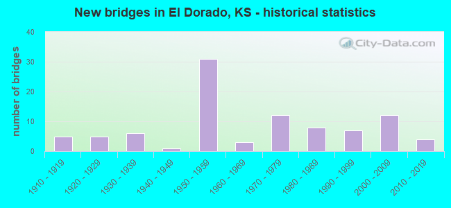
- New bridges - historical statistics
- 51910-1919
- 51920-1929
- 61930-1939
- 11940-1949
- 311950-1959
- 31960-1969
- 121970-1979
- 81980-1989
- 71990-1999
- 122000-2009
- 42010-2019
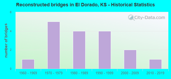
- Reconstructed bridges - Historical Statistics
- 11960-1969
- 51970-1979
- 41980-1989
- 41990-1999
- 22000-2009
- 12010-2019
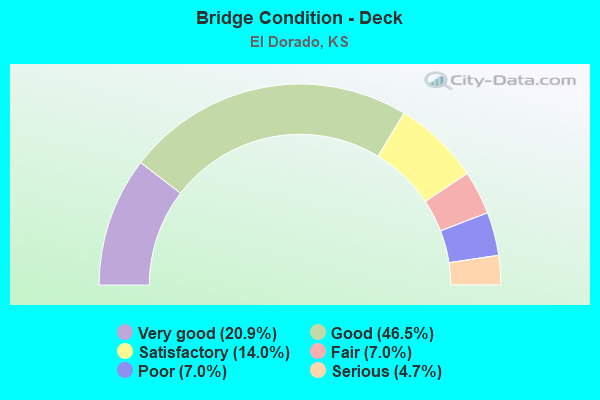
- Bridge Condition - Deck
- 20.9%Very good
- 46.5%Good
- 14.0%Satisfactory
- 7.0%Fair
- 7.0%Poor
- 4.7%Serious
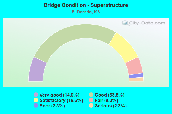
- Bridge Condition - Superstructure
- 14.0%Very good
- 53.5%Good
- 18.6%Satisfactory
- 9.3%Fair
- 2.3%Poor
- 2.3%Serious
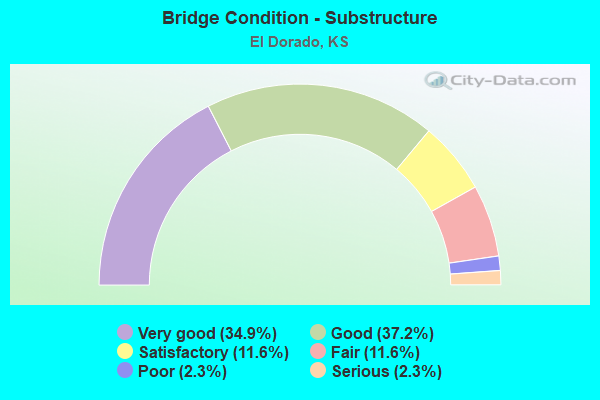
- Bridge Condition - Substructure
- 34.9%Very good
- 37.2%Good
- 11.6%Satisfactory
- 11.6%Fair
- 2.3%Poor
- 2.3%Serious
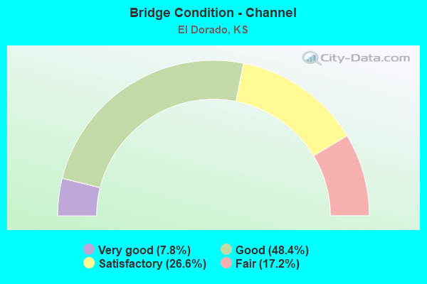
- Bridge Condition - Channel
- 7.8%Very good
- 48.4%Good
- 26.6%Satisfactory
- 17.2%Fair
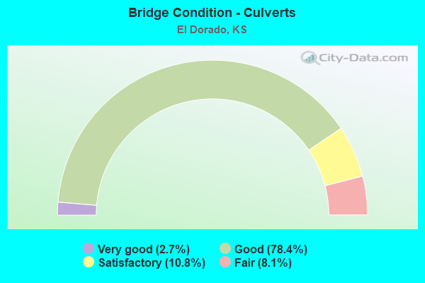
- Bridge Condition - Culverts
- 2.7%Very good
- 78.4%Good
- 10.8%Satisfactory
- 8.1%Fair
Find on map >> Show street view
Structure Number: 999903500080923, Location: 0.69 MI NE K-254 (Lat: 37.824444, Lng: -96.896389), Route carried "on" structure: ServiceCounty highway 1275, Year Built: 1956, Status: Open, Structure Length: 5.07m (16.63ft), Average Daily Traffic: 223 (year 2020), Truck Traffic: 1%, Average Future Daily Traffic: 11,558 (year 2041), Design Load: H 15, Features Intersected: I-35 HWY (KTA), Facility Carried by Structure: OIL HILL ROAD
Minimum Vertical Clearance: 30.47m (99.97ft), Kilometerpoint: 0.124, Lanes on structure: 2, Lanes under structure: 4, Owner: State Toll Authority, Approaching Roadway Width: 7.9m (25.9ft), Material/Design: Steel continuous, Design/Construction: Stringer/Multi-beam, Number Of Spans In Main Unit: 4, Length of Maximum Span: 14.0m (45.9ft), Curb-To-Curb Width: 7.3m (24.0ft), Out-to-Out Width: 8.9m (29.2ft)
Condition: Deck: Good, Superstructure: Good, Substructure: Good, Operating Rating: 37.8 metric tons, Method Used To Determine Operating Rating: Load Factor (LF), Inventory Rating: 22.7 metric tons, Method Used To Determine Inventory Rating: Load Factor (LF), Structural Evaluation: Equal to present minimum criteria, Deck Geometry: Somewhat better than minimum adequacy, Underclear: Meets minimum limits, Approach Roadway Alignment: Somewhat better than minimum adequacy, Length Of Structure Improvement: 16.65m (54.63ft), Designated Inspection Frequency: Every 24 months, Inspection Date: July 2021, Deck Structure Type: Concrete Cast-file-Place, Wearing Surface/Protective System: Wearing Surface: Monolithic Concrete
Find on map >> Show street view
Structure Number: 999903500080933, Location: 0.97 MI NE K-254 (Lat: 37.827222, Lng: -96.893056), Route carried "on" structure: Interstate 35, Year Built: 1956, Year Reconstructed: 1984, Status: Open, Structure Length: 6.42m (21.06ft), Average Daily Traffic: 7,021 (year 2020), Truck Traffic: 30%, Average Future Daily Traffic: 9,836 (year 2041), Design Load: HS 20+Mod, Features Intersected: UP RR
Minimum Vertical Clearance: 30.47m (99.97ft), Kilometerpoint: 27.187, Lanes on structure: 2, Base Highway Network: Yes, Toll: On Interstate toll segment, Owner: State Toll Authority, Approaching Roadway Width: 11.0m (36.1ft), Skew: 4 degrees, Material/Design: Steel continuous, Design/Construction: Stringer/Multi-beam, Number Of Spans In Main Unit: 3, Length of Maximum Span: 22.6m (74.1ft), Curb-To-Curb Width: 9.8m (32.2ft), Out-to-Out Width: 10.5m (34.4ft)
Condition: Deck: Good, Superstructure: Good, Substructure: Good, Operating Rating: 58.6 metric tons, Method Used To Determine Operating Rating: Load Factor (LF), Inventory Rating: 35.1 metric tons, Method Used To Determine Inventory Rating: Load Factor (LF), Structural Evaluation: Better than present minimum criteria, Deck Geometry: Meets minimum limits, Underclear: Superior to present desirable criteria, Approach Roadway Alignment: Equal to present minimum criteria, Length Of Structure Improvement: 21.05m (69.06ft), Designated Inspection Frequency: Every 24 months, Inspection Date: July 2021, Deck Structure Type: Concrete Cast-file-Place, Wearing Surface/Protective System: Wearing Surface: Epoxy Overlay, Deck Protection: Epoxy Coated Reinforcing
Find on map >> Show street view
Structure Number: 999903500080943, Location: 0.96 MI NE K-254 (Lat: 37.827222, Lng: -96.893056), Route carried "on" structure: Interstate 35, Year Built: 1956, Year Reconstructed: 1984, Status: Open, Structure Length: 6.42m (21.06ft), Average Daily Traffic: 7,021 (year 2020), Truck Traffic: 30%, Average Future Daily Traffic: 9,836 (year 2041), Design Load: HS 20+Mod, Features Intersected: UP RR
Minimum Vertical Clearance: 30.47m (99.97ft), Kilometerpoint: 27.253, Lanes on structure: 2, Base Highway Network: Yes, Toll: On Interstate toll segment, Owner: State Toll Authority, Approaching Roadway Width: 11.0m (36.1ft), Skew: 4 degrees, Material/Design: Steel continuous, Design/Construction: Stringer/Multi-beam, Number Of Spans In Main Unit: 3, Length of Maximum Span: 22.6m (74.1ft), Curb-To-Curb Width: 9.8m (32.2ft), Out-to-Out Width: 10.5m (34.4ft)
Condition: Deck: Good, Superstructure: Good, Substructure: Good, Operating Rating: 58.6 metric tons, Method Used To Determine Operating Rating: Load Factor (LF), Inventory Rating: 35.1 metric tons, Method Used To Determine Inventory Rating: Load Factor (LF), Structural Evaluation: Better than present minimum criteria, Deck Geometry: Meets minimum limits, Underclear: Superior to present desirable criteria, Approach Roadway Alignment: Equal to present minimum criteria, Length Of Structure Improvement: 21.05m (69.06ft), Designated Inspection Frequency: Every 24 months, Inspection Date: July 2021, Deck Structure Type: Concrete Cast-file-Place, Wearing Surface/Protective System: Wearing Surface: Epoxy Overlay, Deck Protection: Epoxy Coated Reinforcing
Find on map >> Show street view
Structure Number: 999903500080953, Location: 1.90 MI NE K-254 (Lat: 37.836944, Lng: -96.881111), Route carried "on" structure: Interstate 35, Year Built: 1956, Year Reconstructed: 1984, Status: Open, Structure Length: 7.36m (24.15ft), Average Daily Traffic: 7,021 (year 2020), Truck Traffic: 30%, Average Future Daily Traffic: 9,836 (year 2041), Design Load: HS 20+Mod, Features Intersected: LOCAL ROAD, ABANDONED RR
Minimum Vertical Clearance: 30.47m (99.97ft), Kilometerpoint: 28.706, Lanes on structure: 2, Lanes under structure: 2, Base Highway Network: Yes, Toll: On Interstate toll segment, Owner: State Toll Authority, Approaching Roadway Width: 11.0m (36.1ft), Skew: 1 degrees, Material/Design: Steel continuous, Design/Construction: Stringer/Multi-beam, Number Of Spans In Main Unit: 4, Length of Maximum Span: 20.7m (67.9ft), Curb-To-Curb Width: 9.8m (32.2ft), Out-to-Out Width: 10.5m (34.4ft)
Condition: Deck: Good, Superstructure: Good, Substructure: Good, Operating Rating: 53.8 metric tons, Method Used To Determine Operating Rating: Load Factor (LF), Inventory Rating: 28.8 metric tons, Method Used To Determine Inventory Rating: Load Factor (LF), Structural Evaluation: Better than present minimum criteria, Deck Geometry: Meets minimum limits, Underclear: Superior to present desirable criteria, Approach Roadway Alignment: Equal to present minimum criteria, Length Of Structure Improvement: 24.15m (79.23ft), Designated Inspection Frequency: Every 24 months, Inspection Date: July 2021, Deck Structure Type: Concrete Cast-file-Place, Wearing Surface/Protective System: Wearing Surface: Epoxy Overlay, Deck Protection: Epoxy Coated Reinforcing
Find on map >> Show street view
Structure Number: 999903500080963, Location: 1.91 MI NE K-254 (Lat: 37.836944, Lng: -96.881111), Route carried "on" structure: Interstate 35, Year Built: 1956, Year Reconstructed: 1984, Status: Open, Structure Length: 7.36m (24.15ft), Average Daily Traffic: 7,021 (year 2020), Truck Traffic: 30%, Average Future Daily Traffic: 9,836 (year 2041), Design Load: H 20, Features Intersected: ABANDONED RR, LOCAL ROAD
Minimum Vertical Clearance: 30.47m (99.97ft), Kilometerpoint: 28.765, Lanes on structure: 2, Lanes under structure: 2, Base Highway Network: Yes, Toll: On Interstate toll segment, Owner: State Toll Authority, Approaching Roadway Width: 11.0m (36.1ft), Skew: 1 degrees, Material/Design: Steel continuous, Design/Construction: Stringer/Multi-beam, Number Of Spans In Main Unit: 4, Length of Maximum Span: 20.7m (67.9ft), Curb-To-Curb Width: 9.8m (32.2ft), Out-to-Out Width: 10.5m (34.4ft)
Condition: Deck: Good, Superstructure: Good, Substructure: Good, Operating Rating: 53.8 metric tons, Method Used To Determine Operating Rating: Load Factor (LF), Inventory Rating: 28.8 metric tons, Method Used To Determine Inventory Rating: Load Factor (LF), Structural Evaluation: Better than present minimum criteria, Deck Geometry: Meets minimum limits, Underclear: Superior to present desirable criteria, Approach Roadway Alignment: Equal to present minimum criteria, Length Of Structure Improvement: 24.15m (79.23ft), Designated Inspection Frequency: Every 24 months, Inspection Date: July 2021, Deck Structure Type: Concrete Cast-file-Place, Wearing Surface/Protective System: Wearing Surface: Epoxy Overlay, Deck Protection: Epoxy Coated Reinforcing
Find on map >> Show street view
Structure Number: 999903500080973, Location: 2.23 MI NE K-254 (Lat: 37.840833, Lng: -96.877222), Route carried "on" structure: ServiceCounty highway 876, Year Built: 1956, Status: Open, Structure Length: 8.40m (27.56ft), Average Daily Traffic: 223 (year 2020), Truck Traffic: 1%, Average Future Daily Traffic: 11,558 (year 2041), Design Load: H 15, Features Intersected: I-35 HWY (KTA), Facility Carried by Structure: OIL HILL ROAD
Minimum Vertical Clearance: 30.47m (99.97ft), Kilometerpoint: 7.855, Lanes on structure: 2, Lanes under structure: 4, Owner: State Toll Authority, Approaching Roadway Width: 7.3m (24.0ft), Skew: 5 degrees, Material/Design: Steel continuous, Design/Construction: Stringer/Multi-beam, Number Of Spans In Main Unit: 4, Length of Maximum Span: 23.8m (78.1ft), Curb-To-Curb Width: 7.3m (24.0ft), Out-to-Out Width: 8.9m (29.2ft)
Condition: Deck: Good, Superstructure: Very good, Substructure: Good, Operating Rating: 32.2 metric tons, Method Used To Determine Operating Rating: Load Factor (LF), Inventory Rating: 19.3 metric tons, Method Used To Determine Inventory Rating: Load Factor (LF), Structural Evaluation: Somewhat better than minimum adequacy, Deck Geometry: Somewhat better than minimum adequacy, Underclear: Meets minimum limits, Approach Roadway Alignment: Somewhat better than minimum adequacy, Length Of Structure Improvement: 27.55m (90.39ft), Designated Inspection Frequency: Every 24 months, Inspection Date: July 2021, Deck Structure Type: Concrete Cast-file-Place, Wearing Surface/Protective System: Wearing Surface: Monolithic Concrete
Find on map >> Show street view
Structure Number: 999903500080983, Location: 3.94 MI NE K-254 (Lat: 37.860556, Lng: -96.859444), Route carried "on" structure: Interstate 35, Year Built: 1956, Year Reconstructed: 1985, Status: Open, Structure Length: 5.35m (17.55ft), Average Daily Traffic: 7,021 (year 2020), Truck Traffic: 30%, Average Future Daily Traffic: 9,836 (year 2041), Design Load: HS 20+Mod, Features Intersected: W. BR. WALNUT RIVER DRG.
Minimum Vertical Clearance: 30.47m (99.97ft), Kilometerpoint: 31.974, Lanes on structure: 2, Base Highway Network: Yes, Toll: On Interstate toll segment, Owner: State Toll Authority, Approaching Roadway Width: 11.0m (36.1ft), Skew: 1 degrees, Material/Design: Steel continuous, Design/Construction: Stringer/Multi-beam, Number Of Spans In Main Unit: 3, Length of Maximum Span: 20.4m (66.9ft), Curb-To-Curb Width: 9.8m (32.2ft), Out-to-Out Width: 10.5m (34.4ft)
Condition: Deck: Good, Superstructure: Good, Substructure: Good, Channel: Very good, Operating Rating: 54.8 metric tons, Method Used To Determine Operating Rating: Load Factor (LF), Inventory Rating: 31.1 metric tons, Method Used To Determine Inventory Rating: Load Factor (LF), Structural Evaluation: Better than present minimum criteria, Deck Geometry: High priority of replacement, Waterway Adequacy: Equal to present desirable criteria, Approach Roadway Alignment: Equal to present minimum criteria, Length Of Structure Improvement: 17.55m (57.58ft), Designated Inspection Frequency: Every 24 months, Inspection Date: July 2021, Deck Structure Type: Concrete Cast-file-Place, Wearing Surface/Protective System: Wearing Surface: Epoxy Overlay
Find on map >> Show street view
Structure Number: 999903500080993, Location: 3.93 MI NE K-254 (Lat: 37.860278, Lng: -96.859444), Route carried "on" structure: Interstate 35, Year Built: 1956, Year Reconstructed: 1985, Status: Open, Structure Length: 5.35m (17.55ft), Average Daily Traffic: 7,021 (year 2020), Truck Traffic: 30%, Average Future Daily Traffic: 9,836 (year 2041), Design Load: HS 20+Mod, Features Intersected: W. BR. WALNUT RIVER DRG.
Minimum Vertical Clearance: 30.47m (99.97ft), Kilometerpoint: 32.034, Lanes on structure: 2, Base Highway Network: Yes, Toll: On Interstate toll segment, Owner: State Toll Authority, Approaching Roadway Width: 11.0m (36.1ft), Skew: 1 degrees, Material/Design: Steel continuous, Design/Construction: Stringer/Multi-beam, Number Of Spans In Main Unit: 3, Length of Maximum Span: 20.4m (66.9ft), Curb-To-Curb Width: 9.8m (32.2ft), Out-to-Out Width: 10.5m (34.4ft)
Condition: Deck: Very good, Superstructure: Good, Substructure: Very good, Channel: Good, Operating Rating: 54.8 metric tons, Method Used To Determine Operating Rating: Load Factor (LF), Inventory Rating: 31.1 metric tons, Method Used To Determine Inventory Rating: Load Factor (LF), Structural Evaluation: Better than present minimum criteria, Deck Geometry: High priority of replacement, Waterway Adequacy: Equal to present desirable criteria, Approach Roadway Alignment: Equal to present minimum criteria, Length Of Structure Improvement: 17.55m (57.58ft), Designated Inspection Frequency: Every 24 months, Inspection Date: July 2021, Deck Structure Type: Concrete Cast-file-Place, Wearing Surface/Protective System: Wearing Surface: Epoxy Overlay
Find on map >> Show street view
Structure Number: 999903500081003, Location: 4.60 MI NE K-254 (Lat: 37.869444, Lng: -96.855278), Route carried "on" structure: Interstate 35, Year Built: 1956, Year Reconstructed: 1985, Status: Open, Structure Length: 8.79m (28.84ft), Average Daily Traffic: 7,021 (year 2020), Truck Traffic: 30%, Average Future Daily Traffic: 9,836 (year 2041), Design Load: HS 20+Mod, Features Intersected: W.BR. WALNUT RIVER
Minimum Vertical Clearance: 30.47m (99.97ft), Kilometerpoint: 33.043, Lanes on structure: 2, Lanes under structure: 2, Base Highway Network: Yes, Toll: On Interstate toll segment, Owner: State Toll Authority, Approaching Roadway Width: 11.0m (36.1ft), Skew: 1 degrees, Material/Design: Steel continuous, Design/Construction: Stringer/Multi-beam, Number Of Spans In Main Unit: 3, Length of Maximum Span: 33.5m (109.9ft), Curb-To-Curb Width: 9.8m (32.2ft), Out-to-Out Width: 10.5m (34.4ft)
Condition: Deck: Good, Superstructure: Good, Substructure: Good, Channel: Very good, Operating Rating: 59.2 metric tons, Method Used To Determine Operating Rating: Load Factor (LF), Inventory Rating: 35.6 metric tons, Method Used To Determine Inventory Rating: Load Factor (LF), Structural Evaluation: Better than present minimum criteria, Deck Geometry: Meets minimum limits, Waterway Adequacy: Equal to present desirable criteria, Approach Roadway Alignment: Equal to present minimum criteria, Length Of Structure Improvement: 28.85m (94.65ft), Designated Inspection Frequency: Every 24 months, Inspection Date: July 2021, Deck Structure Type: Concrete Cast-file-Place, Wearing Surface/Protective System: Wearing Surface: Epoxy Overlay
Find on map >> Show street view
Structure Number: 999903500081013, Location: 4.59 MI NE K-254 (Lat: 37.869444, Lng: -96.855278), Route carried "on" structure: Interstate 35, Year Built: 1956, Year Reconstructed: 1985, Status: Open, Structure Length: 8.79m (28.84ft), Average Daily Traffic: 7,021 (year 2020), Truck Traffic: 30%, Average Future Daily Traffic: 9,836 (year 2041), Design Load: HS 20+Mod, Features Intersected: W.BR WALNUT R. & ROCK RD
Minimum Vertical Clearance: 30.47m (99.97ft), Kilometerpoint: 33.096, Lanes on structure: 2, Lanes under structure: 2, Base Highway Network: Yes, Toll: On Interstate toll segment, Owner: State Toll Authority, Approaching Roadway Width: 11.0m (36.1ft), Skew: 1 degrees, Material/Design: Steel continuous, Design/Construction: Stringer/Multi-beam, Number Of Spans In Main Unit: 3, Length of Maximum Span: 33.5m (109.9ft), Curb-To-Curb Width: 9.8m (32.2ft), Out-to-Out Width: 10.5m (34.4ft)
Condition: Deck: Very good, Superstructure: Good, Substructure: Good, Channel: Good, Operating Rating: 59.2 metric tons, Method Used To Determine Operating Rating: Load Factor (LF), Inventory Rating: 35.6 metric tons, Method Used To Determine Inventory Rating: Load Factor (LF), Structural Evaluation: Better than present minimum criteria, Deck Geometry: Meets minimum limits, Waterway Adequacy: Equal to present desirable criteria, Approach Roadway Alignment: Equal to present minimum criteria, Length Of Structure Improvement: 28.85m (94.65ft), Designated Inspection Frequency: Every 24 months, Inspection Date: July 2021, Deck Structure Type: Concrete Cast-file-Place, Wearing Surface/Protective System: Wearing Surface: Epoxy Overlay
Find on map >> Show street view
Structure Number: 999903500081543, Location: 0. MI NE U77 (Lat: 37.875833, Lng: -96.846111), Route carried "on" structure: Ramp State highway 3, Year Built: 1986, Status: Open, Structure Length: 6.12m (20.08ft), Average Daily Traffic: 990 (year 2020), Truck Traffic: 5%, Average Future Daily Traffic: 11,558 (year 2041), Design Load: HS 20, Features Intersected: I35(KTA) HWY, Facility Carried by Structure: N.ELDORADO IC RAMP
Minimum Vertical Clearance: 30.47m (99.97ft), Kilometerpoint: 0.304, Lanes on structure: 2, Lanes under structure: 5, Owner: State Toll Authority, Approaching Roadway Width: 14.6m (47.9ft), Skew: 21 degrees, Material/Design: Prestressed concrete continuous, Design/Construction: Stringer/Multi-beam, Number Of Spans In Main Unit: 3, Length of Maximum Span: 33.8m (110.9ft), Curb-To-Curb Width: 11.7m (38.4ft), Out-to-Out Width: 12.4m (40.7ft)
Condition: Deck: Good, Superstructure: Good, Substructure: Good, Operating Rating: 50.4 metric tons, Method Used To Determine Operating Rating: Load Factor (LF), Inventory Rating: 30.2 metric tons, Method Used To Determine Inventory Rating: Load Factor (LF), Structural Evaluation: Better than present minimum criteria, Deck Geometry: Superior to present desirable criteria, Underclear: High priority of corrective action, Approach Roadway Alignment: Meets minimum limits, Length Of Structure Improvement: 20.07m (65.85ft), Designated Inspection Frequency: Every 24 months, Inspection Date: July 2021, Deck Structure Type: Concrete Cast-file-Place, Wearing Surface/Protective System: Wearing Surface: Monolithic Concrete
Find on map >> Show street view
Structure Number: 999903500081573, Location: K-254 JCT (Lat: 37.816944, Lng: -96.905278), Route carried "on" structure: Interstate 35, Year Built: 1955, Year Reconstructed: 1995, Status: Open, Structure Length: 0.65m (2.13ft), Average Daily Traffic: 7,071 (year 2020), Truck Traffic: 27%, Average Future Daily Traffic: 8,800 (year 2041), Design Load: H 20, Features Intersected: CONSTATNT CREEK DRAINAGE
Minimum Vertical Clearance: 30.47m (99.97ft), Kilometerpoint: 25.675, Lanes on structure: 4, Base Highway Network: Yes, Toll: On Interstate toll segment, Owner: State Toll Authority, Approaching Roadway Width: 27.4m (89.9ft), Skew: 21 degrees, Material/Design: Concrete, Design/Construction: Culvert, Number Of Spans In Main Unit: 2, Length of Maximum Span: 3.0m (9.8ft), Curb-To-Curb Width: 27.4m (89.9ft), Out-to-Out Width: 109.0m (357.6ft)
Condition: Channel: Good, Culverts: Good, Operating Rating: 82.2 metric tons, Method Used To Determine Operating Rating: Load Factor (LF), Inventory Rating: 49.2 metric tons, Method Used To Determine Inventory Rating: Load Factor (LF), Structural Evaluation: Better than present minimum criteria, Deck Geometry: Superior to present desirable criteria, Waterway Adequacy: Better than present minimum criteria, Approach Roadway Alignment: Equal to present desirable criteria, Length Of Structure Improvement: 2.13m (6.99ft), Designated Inspection Frequency: Every 24 months, Inspection Date: July 2021, Deck Structure Type: Concrete Cast-file-Place, Wearing Surface/Protective System: Wearing Surface: Bituminous
Find on map >> Show street view
Structure Number: 999903500081583, Location: 0.37 MI NE K-254 (Lat: 37.821111, Lng: -96.900278), Route carried "on" structure: Interstate 35, Year Built: 1955, Year Reconstructed: 2017, Status: Open, Structure Length: 0.76m (2.49ft), Average Daily Traffic: 7,071 (year 2020), Truck Traffic: 30%, Average Future Daily Traffic: 9,906 (year 2041), Design Load: H 20, Features Intersected: CONSTATNT CREEK
Minimum Vertical Clearance: 30.47m (99.97ft), Kilometerpoint: 26.310, Lanes on structure: 4, Base Highway Network: Yes, Toll: On Interstate toll segment, Owner: State Toll Authority, Approaching Roadway Width: 34.8m (114.2ft), Skew: 20 degrees, Material/Design: Concrete, Design/Construction: Culvert, Number Of Spans In Main Unit: 2, Length of Maximum Span: 3.7m (12.1ft), Curb-To-Curb Width: 41.1m (134.8ft), Out-to-Out Width: 47.6m (156.2ft)
Condition: Channel: Good, Culverts: Good, Operating Rating: 89.8 metric tons, Method Used To Determine Operating Rating: Load Factor (LF), Inventory Rating: 59.0 metric tons, Method Used To Determine Inventory Rating: Load Factor (LF), Structural Evaluation: Better than present minimum criteria, Deck Geometry: Superior to present desirable criteria, Waterway Adequacy: Better than present minimum criteria, Approach Roadway Alignment: Equal to present desirable criteria, Length Of Structure Improvement: 2.49m (8.17ft), Designated Inspection Frequency: Every 24 months, Inspection Date: July 2021, Deck Structure Type: Concrete Cast-file-Place, Wearing Surface/Protective System: Wearing Surface: Bituminous
Find on map >> Show street view
Structure Number: 999905400080121, Location: 2.62 MI. N U-400 E JCT (Lat: 37.716944, Lng: -96.844167), Route carried "on" structure: US 54, Year Built: 1971, Year Reconstructed: 2003, Status: Open, Structure Length: 0.87m (2.85ft), Average Daily Traffic: 1,233 (year 2020), Truck Traffic: 26%, Average Future Daily Traffic: 1,596 (year 2041), Design Load: H 20, Features Intersected: TURKEY CREEK DRAINAGE
Minimum Vertical Clearance: 30.47m (99.97ft), Kilometerpoint: 32.372, Lanes on structure: 4, Base Highway Network: Yes, Owner: State Highway Agency, Approaching Roadway Width: 12.2m (40.0ft), Skew: 23 degrees, Material/Design: Concrete, Design/Construction: Culvert, Number Of Spans In Main Unit: 2, Length of Maximum Span: 3.7m (12.1ft), Curb-To-Curb Width: 12.2m (40.0ft), Out-to-Out Width: 28.0m (91.9ft)
Condition: Channel: Good, Culverts: Good, Operating Rating: 54.5 metric tons, Method Used To Determine Operating Rating: Load Factor (LF), Inventory Rating: 32.7 metric tons, Method Used To Determine Inventory Rating: Load Factor (LF), Structural Evaluation: Better than present minimum criteria, Deck Geometry: High priority of replacement, Waterway Adequacy: Equal to present desirable criteria, Approach Roadway Alignment: Equal to present desirable criteria, Length Of Structure Improvement: 2.86m (9.38ft), Designated Inspection Frequency: Every 24 months, Inspection Date: October 2020, Deck Structure Type: Concrete Cast-file-Place, Wearing Surface/Protective System: Wearing Surface: Bituminous
Find on map >> Show street view
Structure Number: 999905400080141, Location: 3.66 MI. N U-400 E JCT (Lat: 37.731944, Lng: -96.844444), Route carried "on" structure: US 54, Year Built: 1971, Status: Open, Structure Length: 4.65m (15.26ft), Average Daily Traffic: 1,258 (year 2020), Truck Traffic: 24%, Average Future Daily Traffic: 1,629 (year 2041), Design Load: HS 20, Features Intersected: CAVE SPRINGS CREEK
Minimum Vertical Clearance: 30.47m (99.97ft), Kilometerpoint: 33.817, Lanes on structure: 2, Base Highway Network: Yes, Owner: State Highway Agency, Approaching Roadway Width: 12.2m (40.0ft), Material/Design: Concrete continuous, Design/Construction: Slab, Number Of Spans In Main Unit: 3, Length of Maximum Span: 18.3m (60.0ft), Curb-To-Curb Width: 12.2m (40.0ft), Out-to-Out Width: 12.8m (42.0ft)
Condition: Deck: Satisfactory, Superstructure: Satisfactory, Substructure: Very good, Channel: Good, Operating Rating: 63.5 metric tons, Method Used To Determine Operating Rating: Load Factor (LF), Inventory Rating: 38.1 metric tons, Method Used To Determine Inventory Rating: Load Factor (LF), Structural Evaluation: Equal to present minimum criteria, Deck Geometry: Better than present minimum criteria, Waterway Adequacy: Better than present minimum criteria, Approach Roadway Alignment: Better than present minimum criteria, Length Of Structure Improvement: 15.25m (50.03ft), Designated Inspection Frequency: Every 24 months, Inspection Date: October 2020, Deck Structure Type: Concrete Cast-file-Place, Wearing Surface/Protective System: Wearing Surface: Low Slump Concrete
Find on map >> Show street view
Structure Number: 999905400080161, Location: 4.58 MI N U-400 E JCT (Lat: 37.745278, Lng: -96.844167), Route carried "on" structure: US 54, Year Built: 1971, Status: Open, Structure Length: 5.62m (18.44ft), Average Daily Traffic: 1,258 (year 2020), Truck Traffic: 24%, Average Future Daily Traffic: 1,629 (year 2041), Design Load: HS 20, Features Intersected: TURKEY CREEK
Minimum Vertical Clearance: 30.47m (99.97ft), Kilometerpoint: 35.286, Lanes on structure: 2, Base Highway Network: Yes, Owner: State Highway Agency, Approaching Roadway Width: 12.2m (40.0ft), Material/Design: Concrete continuous, Design/Construction: Slab, Number Of Spans In Main Unit: 4, Length of Maximum Span: 15.8m (51.8ft), Curb-To-Curb Width: 12.2m (40.0ft), Out-to-Out Width: 12.8m (42.0ft)
Condition: Deck: Good, Superstructure: Good, Substructure: Very good, Channel: Good, Operating Rating: 62.6 metric tons, Method Used To Determine Operating Rating: Load Factor (LF), Inventory Rating: 37.2 metric tons, Method Used To Determine Inventory Rating: Load Factor (LF), Structural Evaluation: Better than present minimum criteria, Deck Geometry: Better than present minimum criteria, Waterway Adequacy: Equal to present minimum criteria, Approach Roadway Alignment: Better than present minimum criteria, Length Of Structure Improvement: 18.45m (60.53ft), Designated Inspection Frequency: Every 24 months, Inspection Date: October 2020, Deck Structure Type: Concrete Cast-file-Place, Wearing Surface/Protective System: Wearing Surface: Low Slump Concrete
Find on map >> Show street view
Structure Number: 999905400080181, Location: 6.46 MI N U-400 E JCT (Lat: 37.772222, Lng: -96.843889), Route carried "on" structure: US 54, Year Built: 1971, Year Reconstructed: 2003, Status: Open, Structure Length: 0.76m (2.49ft), Average Daily Traffic: 1,258 (year 2020), Truck Traffic: 24%, Average Future Daily Traffic: 1,629 (year 2041), Design Load: H 20, Features Intersected: WALNUT RIVER DRAINAGE
Minimum Vertical Clearance: 30.47m (99.97ft), Kilometerpoint: 38.547, Lanes on structure: 4, Base Highway Network: Yes, Owner: State Highway Agency, Approaching Roadway Width: 12.2m (40.0ft), Skew: 20 degrees, Material/Design: Concrete, Design/Construction: Culvert, Number Of Spans In Main Unit: 2, Length of Maximum Span: 3.7m (12.1ft), Curb-To-Curb Width: 12.2m (40.0ft), Out-to-Out Width: 87.5m (287.1ft)
Condition: Channel: Good, Culverts: Good, Inventory Rating: 11.0 metric tons, Method Used To Determine Inventory Rating: Load Factor (LF), Structural Evaluation: High priority of corrective action, Deck Geometry: High priority of replacement, Waterway Adequacy: Equal to present minimum criteria, Approach Roadway Alignment: Equal to present desirable criteria, Length Of Structure Improvement: 2.48m (8.14ft), Designated Inspection Frequency: Every 24 months, Inspection Date: October 2020, Deck Structure Type: Concrete Cast-file-Place, Wearing Surface/Protective System: Wearing Surface: Bituminous
Find on map >> Show street view
Structure Number: 999905400080254, Location: O.55 MI. E US-77 N JCT (Lat: 37.816667, Lng: -96.839444), Route carried "on" structure: US 54, Year Built: 1956, Status: Open, Structure Length: 15.93m (52.26ft), Average Daily Traffic: 4,958 (year 2020), Truck Traffic: 12%, Average Future Daily Traffic: 5,700 (year 2041), Design Load: HS 20, Features Intersected: WALNUT RIVER
Minimum Vertical Clearance: 5.29m (17.36ft), Kilometerpoint: 44.553, Lanes on structure: 2, Base Highway Network: Yes, Owner: State Highway Agency, Approaching Roadway Width: 12.2m (40.0ft), Material/Design: Concrete continuous, Design/Construction: Box Beam or Girders - Multiple, Number Of Spans In Main Unit: 5, Number Of Approach Spans: 3, Length of Maximum Span: 27.4m (89.9ft), Curb-To-Curb Width: 8.5m (27.9ft), Out-to-Out Width: 9.7m (31.8ft)
Condition: Deck: Satisfactory, Superstructure: Satisfactory, Substructure: Satisfactory, Channel: Satisfactory, Operating Rating: 72.9 metric tons, Method Used To Determine Operating Rating: Load Factor (LF), Inventory Rating: 43.7 metric tons, Method Used To Determine Inventory Rating: Load Factor (LF), Structural Evaluation: Equal to present minimum criteria, Deck Geometry: Meets minimum limits, Waterway Adequacy: Equal to present minimum criteria, Approach Roadway Alignment: Meets minimum limits, Length Of Structure Improvement: 52.25m (171.42ft), Designated Inspection Frequency: Every 24 months, Inspection Date: October 2020, Deck Structure Type: Concrete Cast-file-Place, Wearing Surface/Protective System: Wearing Surface: Epoxy Overlay
Find on map >> Show street view
Structure Number: 999905400080271, Location: 1.50 MI. E US-77 N JCT (Lat: 37.811944, Lng: -96.822222), Route carried "on" structure: ServiceCounty highway 1850, Year Built: 1956, Status: Open, Structure Length: 0.68m (2.23ft), Average Daily Traffic: 223 (year 2020), Truck Traffic: 1%, Average Future Daily Traffic: 6,070 (year 2041), Design Load: H 20, Features Intersected: WALNUT RIVER DRAINAGE, Facility Carried by Structure: ENTRANCE ON RIGHT
Minimum Vertical Clearance: 30.47m (99.97ft), Kilometerpoint: 0.043, Lanes on structure: 2, Owner: State Highway Agency, Approaching Roadway Width: 7.3m (24.0ft), Material/Design: Concrete, Design/Construction: Culvert, Number Of Spans In Main Unit: 3, Length of Maximum Span: 2.1m (6.9ft), Curb-To-Curb Width: 7.3m (24.0ft), Out-to-Out Width: 7.8m (25.6ft)
Condition: Channel: Good, Culverts: Good, Operating Rating: 26.5 metric tons, Method Used To Determine Operating Rating: Load Factor (LF), Inventory Rating: 15.9 metric tons, Method Used To Determine Inventory Rating: Load Factor (LF), Structural Evaluation: Meets minimum limits, Deck Geometry: Somewhat better than minimum adequacy, Waterway Adequacy: Meets minimum limits, Approach Roadway Alignment: Somewhat better than minimum adequacy, Length Of Structure Improvement: 2.22m (7.28ft), Designated Inspection Frequency: Every 24 months, Inspection Date: October 2020, Deck Structure Type: Concrete Cast-file-Place, Wearing Surface/Protective System: Wearing Surface: Bituminous
Find on map >> Show street view
Structure Number: 999905400081461, Location: 1.16 MI E US77 NJCT (Lat: 37.814167, Lng: -96.829167), Route carried "on" structure: US 54, Year Built: 1987, Status: Open, Structure Length: 3.12m (10.24ft), Average Daily Traffic: 4,958 (year 2020), Truck Traffic: 12%, Average Future Daily Traffic: 5,700 (year 2041), Design Load: HS 20, Features Intersected: WALNUT RIVER OVERFLOW
Minimum Vertical Clearance: 30.47m (99.97ft), Kilometerpoint: 45.520, Lanes on structure: 2, Base Highway Network: Yes, Owner: State Highway Agency, Approaching Roadway Width: 13.4m (44.0ft), Material/Design: Concrete continuous, Design/Construction: Slab, Number Of Spans In Main Unit: 3, Length of Maximum Span: 12.2m (40.0ft), Curb-To-Curb Width: 13.4m (44.0ft), Out-to-Out Width: 14.0m (45.9ft)
Condition: Deck: Good, Superstructure: Good, Substructure: Very good, Channel: Very good, Operating Rating: 68.0 metric tons, Method Used To Determine Operating Rating: Load Factor (LF), Inventory Rating: 40.8 metric tons, Method Used To Determine Inventory Rating: Load Factor (LF), Structural Evaluation: Better than present minimum criteria, Deck Geometry: Better than present minimum criteria, Waterway Adequacy: Equal to present desirable criteria, Approach Roadway Alignment: Equal to present desirable criteria, Length Of Structure Improvement: 10.25m (33.63ft), Designated Inspection Frequency: Every 24 months, Inspection Date: October 2020, Wearing Surface/Protective System: Wearing Surface: Monolithic Concrete, Deck Protection: Epoxy Coated Reinforcing
Find on map >> Show street view
Structure Number: 999905400081491, Location: 7.81 MI N U-400 E JCT (Lat: 37.800556, Lng: -96.845000), Route carried "on" structure: US 54, Year Built: 1988, Status: Open, Structure Length: 1.55m (5.09ft), Average Daily Traffic: 2,864 (year 2020), Truck Traffic: 23%, Average Future Daily Traffic: 3,708 (year 2041), Design Load: H 20, Features Intersected: WALNUT RIVER DRAINAGE
Minimum Vertical Clearance: 30.47m (99.97ft), Kilometerpoint: 41.716, Lanes on structure: 2, Base Highway Network: Yes, Owner: State Highway Agency, Approaching Roadway Width: 13.4m (44.0ft), Material/Design: Concrete, Design/Construction: Culvert, Number Of Spans In Main Unit: 6, Length of Maximum Span: 2.4m (7.9ft), Curb-To-Curb Width: 13.4m (44.0ft), Out-to-Out Width: 18.8m (61.7ft)
Condition: Channel: Good, Culverts: Very good, Operating Rating: 36.4 metric tons, Method Used To Determine Operating Rating: Load Factor (LF), Inventory Rating: 21.8 metric tons, Method Used To Determine Inventory Rating: Load Factor (LF), Structural Evaluation: Somewhat better than minimum adequacy, Deck Geometry: Better than present minimum criteria, Waterway Adequacy: Equal to present desirable criteria, Approach Roadway Alignment: Meets minimum limits, Length Of Structure Improvement: 5.10m (16.73ft), Designated Inspection Frequency: Every 24 months, Inspection Date: October 2020, Deck Structure Type: Concrete Cast-file-Place, Wearing Surface/Protective System: Wearing Surface: Bituminous
Find on map >> Show street view
Structure Number: 999905400081501, Location: 8.70 MI N U-400 E JCT (Lat: 37.803889, Lng: -96.847500), Route carried "on" structure: US 54, Year Built: 1988, Status: Open, Structure Length: 3.73m (12.24ft), Average Daily Traffic: 2,864 (year 2020), Truck Traffic: 23%, Average Future Daily Traffic: 3,708 (year 2041), Design Load: HS 20, Features Intersected: COAL CREEK
Minimum Vertical Clearance: 30.47m (99.97ft), Kilometerpoint: 42.149, Lanes on structure: 2, Base Highway Network: Yes, Owner: State Highway Agency, Approaching Roadway Width: 13.4m (44.0ft), Material/Design: Concrete continuous, Design/Construction: Slab, Number Of Spans In Main Unit: 3, Length of Maximum Span: 14.6m (47.9ft), Curb-To-Curb Width: 13.4m (44.0ft), Out-to-Out Width: 14.0m (45.9ft)
Condition: Deck: Good, Superstructure: Very good, Substructure: Very good, Channel: Good, Operating Rating: 51.7 metric tons, Method Used To Determine Operating Rating: Load Factor (LF), Inventory Rating: 30.8 metric tons, Method Used To Determine Inventory Rating: Load Factor (LF), Structural Evaluation: Better than present minimum criteria, Deck Geometry: Better than present minimum criteria, Waterway Adequacy: Equal to present desirable criteria, Approach Roadway Alignment: Meets minimum limits, Length Of Structure Improvement: 12.25m (40.19ft), Designated Inspection Frequency: Every 24 months, Inspection Date: October 2020, Wearing Surface/Protective System: Wearing Surface: Monolithic Concrete, Deck Protection: Epoxy Coated Reinforcing
Find on map >> Show street view
Structure Number: 999905400081511, Location: 9.04 MI N U-400 E JCT (Lat: 37.808611, Lng: -96.849722), Route carried "on" structure: US 54, Year Built: 1988, Status: Open, Structure Length: 9.50m (31.17ft), Average Daily Traffic: 2,864 (year 2020), Truck Traffic: 23%, Average Future Daily Traffic: 3,708 (year 2041), Design Load: HS 20, Features Intersected: WALNUT RIVER
Minimum Vertical Clearance: 30.47m (99.97ft), Kilometerpoint: 42.717, Lanes on structure: 2, Base Highway Network: Yes, Owner: State Highway Agency, Approaching Roadway Width: 13.4m (44.0ft), Skew: 4 degrees, Material/Design: Concrete continuous, Design/Construction: Slab, Number Of Spans In Main Unit: 6, Length of Maximum Span: 17.1m (56.1ft), Curb-To-Curb Width: 13.4m (44.0ft), Out-to-Out Width: 14.0m (45.9ft)
Condition: Deck: Satisfactory, Superstructure: Good, Substructure: Good, Channel: Satisfactory, Operating Rating: 57.2 metric tons, Method Used To Determine Operating Rating: Load Factor (LF), Inventory Rating: 34.5 metric tons, Method Used To Determine Inventory Rating: Load Factor (LF), Structural Evaluation: Better than present minimum criteria, Deck Geometry: Better than present minimum criteria, Waterway Adequacy: Better than present minimum criteria, Approach Roadway Alignment: Meets minimum limits, Length Of Structure Improvement: 31.15m (102.20ft), Designated Inspection Frequency: Every 24 months, Underwater Inspection Frequency: Every 48 months, Inspection Date: October 2020, Underwater Inspection Date: March 2021, Wearing Surface/Protective System: Wearing Surface: Monolithic Concrete, Deck Protection: Epoxy Coated Reinforcing
Find on map >> Show street view
Structure Number: 999905400081851, Location: 3.67 MI N U400 E JCT (Lat: 37.731944, Lng: -96.844167), Route carried "on" structure: US 54, Year Built: 2004, Status: Open, Structure Length: 4.58m (15.03ft), Average Daily Traffic: 1,258 (year 2020), Truck Traffic: 24%, Average Future Daily Traffic: 1,629 (year 2041), Design Load: HS 25 or greater, Features Intersected: CAVE SPRINGS CREEK
Minimum Vertical Clearance: 30.47m (99.97ft), Kilometerpoint: 34.062, Lanes on structure: 2, Base Highway Network: Yes, Owner: State Highway Agency, Approaching Roadway Width: 12.2m (40.0ft), Material/Design: Concrete continuous, Design/Construction: Slab, Number Of Spans In Main Unit: 3, Length of Maximum Span: 18.0m (59.1ft), Curb-To-Curb Width: 12.2m (40.0ft), Out-to-Out Width: 12.8m (42.0ft)
Condition: Deck: Good, Superstructure: Very good, Substructure: Very good, Channel: Good, Operating Rating: 73.5 metric tons, Method Used To Determine Operating Rating: Load Factor (LF), Inventory Rating: 44.5 metric tons, Method Used To Determine Inventory Rating: Load Factor (LF), Structural Evaluation: Equal to present desirable criteria, Deck Geometry: Better than present minimum criteria, Waterway Adequacy: Equal to present desirable criteria, Approach Roadway Alignment: Equal to present desirable criteria, Length Of Structure Improvement: 15.01m (49.25ft), Designated Inspection Frequency: Every 24 months, Inspection Date: October 2020, Wearing Surface/Protective System: Wearing Surface: Monolithic Concrete, Deck Protection: Epoxy Coated Reinforcing
Find on map >> Show street view
Structure Number: 999905400081861, Location: 4.57MI N U400 E JCT (Lat: 37.745278, Lng: -96.843889), Route carried "on" structure: US 54, Year Built: 2003, Status: Open, Structure Length: 5.68m (18.64ft), Average Daily Traffic: 1,258 (year 2020), Truck Traffic: 24%, Average Future Daily Traffic: 1,629 (year 2041), Design Load: HS 25 or greater, Features Intersected: TURKEY CREEK
Minimum Vertical Clearance: 30.47m (99.97ft), Kilometerpoint: 35.529, Lanes on structure: 2, Base Highway Network: Yes, Owner: State Highway Agency, Approaching Roadway Width: 12.2m (40.0ft), Material/Design: Concrete continuous, Design/Construction: Slab, Number Of Spans In Main Unit: 4, Length of Maximum Span: 16.0m (52.5ft), Curb-To-Curb Width: 12.2m (40.0ft), Out-to-Out Width: 12.8m (42.0ft)
Condition: Deck: Very good, Superstructure: Very good, Substructure: Very good, Channel: Good, Operating Rating: 70.8 metric tons, Method Used To Determine Operating Rating: Load Factor (LF), Inventory Rating: 42.6 metric tons, Method Used To Determine Inventory Rating: Load Factor (LF), Structural Evaluation: Equal to present desirable criteria, Deck Geometry: Better than present minimum criteria, Waterway Adequacy: Equal to present desirable criteria, Approach Roadway Alignment: Equal to present desirable criteria, Length Of Structure Improvement: 18.62m (61.09ft), Designated Inspection Frequency: Every 24 months, Inspection Date: October 2020, Wearing Surface/Protective System: Wearing Surface: Monolithic Concrete, Deck Protection: Epoxy Coated Reinforcing
Find on map >> Show street view
Structure Number: 999907700080321, Location: 0.65 MI. N OF US-54 N JCT (Lat: 37.826667, Lng: -96.849167), Route carried "on" structure: US 77, Year Built: 1935, Year Reconstructed: 2007, Status: Open, Structure Length: 5.88m (19.29ft), Average Daily Traffic: 11,643 (year 2020), Truck Traffic: 4%, Average Future Daily Traffic: 14,207 (year 2041), Design Load: H 15, Features Intersected: W BR WALNUT RIV/PED PASS
Minimum Vertical Clearance: 30.47m (99.97ft), Kilometerpoint: 52.539, Lanes on structure: 5, Base Highway Network: Yes, Owner: State Highway Agency, Approaching Roadway Width: 19.5m (64.0ft), Material/Design: Steel continuous, Design/Construction: Stringer/Multi-beam, Number Of Spans In Main Unit: 3, Length of Maximum Span: 21.3m (69.9ft), Curb or Sidewalk Widths: Left: 1.8m (5.9ft), Right: 3.7m (12.1ft), Curb-To-Curb Width: 19.5m (64.0ft), Out-to-Out Width: 26.5m (86.9ft)
Condition: Deck: Very good, Superstructure: Good, Substructure: Good, Channel: Satisfactory, Operating Rating: 45.4 metric tons, Method Used To Determine Operating Rating: Load Factor (LF), Inventory Rating: 27.1 metric tons, Method Used To Determine Inventory Rating: Load Factor (LF), Structural Evaluation: Equal to present minimum criteria, Deck Geometry: Meets minimum limits, Waterway Adequacy: Meets minimum limits, Approach Roadway Alignment: Equal to present desirable criteria, Length Of Structure Improvement: 19.30m (63.32ft), Designated Inspection Frequency: Every 24 months, Inspection Date: October 2020, Wearing Surface/Protective System: Wearing Surface: Low Slump Concrete, Deck Protection: Epoxy Coated Reinforcing
Find on map >> Show street view
Structure Number: 999907700081761, Location: I-35/US-77 JCTN (Lat: 37.873333, Lng: -96.850000), Route carried "on" structure: US 77, Year Built: 2007, Status: Open, Structure Length: 7.11m (23.33ft), Average Daily Traffic: 837 (year 2020), Truck Traffic: 15%, Average Future Daily Traffic: 1,084 (year 2041), Design Load: HL 93, Features Intersected: I-35 HWY (KTA)
Minimum Vertical Clearance: 30.47m (99.97ft), Kilometerpoint: 57.491, Lanes on structure: 2, Lanes under structure: 4, Base Highway Network: Yes, Owner: State Highway Agency, Approaching Roadway Width: 12.2m (40.0ft), Skew: 3 degrees, Material/Design: Steel continuous, Design/Construction: Stringer/Multi-beam, Number Of Spans In Main Unit: 4, Length of Maximum Span: 20.0m (65.6ft), Curb-To-Curb Width: 12.2m (40.0ft), Out-to-Out Width: 13.0m (42.7ft)
Condition: Deck: Very good, Superstructure: Good, Substructure: Very good, Operating Rating: 50.5 metric tons, Method Used To Determine Operating Rating: Load and Resistance Factor Rating (LRFR) rating reported by rating factor(RF) method using HL-93 loadings, Inventory Rating: 38.9 metric tons, Method Used To Determine Inventory Rating: Load and Resistance Factor Rating (LRFR) rating reported by rating factor(RF) method using HL-93 loadings, Structural Evaluation: Better than present minimum criteria, Deck Geometry: Equal to present desirable criteria, Underclear: High priority of corrective action, Approach Roadway Alignment: Better than present minimum criteria, Length Of Structure Improvement: 23.34m (76.57ft), Designated Inspection Frequency: Every 24 months, Inspection Date: October 2020, Wearing Surface/Protective System: Wearing Surface: Low Slump Concrete, Deck Protection: Epoxy Coated Reinforcing
Find on map >> Show street view
Structure Number: 999907700081781, Location: 1.49 MI S JCT I-35/US-77 (Lat: 37.851944, Lng: -96.849722), Route carried "on" structure: US 77, Year Built: 2007, Status: Open, Structure Length: 0.63m (2.07ft), Average Daily Traffic: 2,598 (year 2020), Truck Traffic: 15%, Average Future Daily Traffic: 3,364 (year 2041), Design Load: HS 15, Features Intersected: W BR WALNUT RIVER DRG.
Minimum Vertical Clearance: 30.47m (99.97ft), Kilometerpoint: 55.352, Lanes on structure: 4, Base Highway Network: Yes, Owner: State Highway Agency, Approaching Roadway Width: 19.5m (64.0ft), Skew: 3 degrees, Material/Design: Concrete, Design/Construction: Culvert, Number Of Spans In Main Unit: 2, Length of Maximum Span: 3.1m (10.2ft), Curb-To-Curb Width: 39.4m (129.3ft), Out-to-Out Width: 46.0m (150.9ft)
Condition: Channel: Good, Culverts: Good, Operating Rating: 98.9 metric tons, Method Used To Determine Operating Rating: Load Factor (LF), Inventory Rating: 59.0 metric tons, Method Used To Determine Inventory Rating: Load Factor (LF), Structural Evaluation: Better than present minimum criteria, Deck Geometry: Superior to present desirable criteria, Waterway Adequacy: Equal to present desirable criteria, Approach Roadway Alignment: Equal to present desirable criteria, Length Of Structure Improvement: 2.07m (6.79ft), Designated Inspection Frequency: Every 24 months, Inspection Date: October 2020, Deck Structure Type: Concrete Cast-file-Place, Wearing Surface/Protective System: Wearing Surface: Bituminous
Find on map >> Show street view
Structure Number: 999907700081791, Location: .66 MI S JCT I-35/US-77 (Lat: 37.863889, Lng: -96.849722), Route carried "on" structure: US 77, Year Built: 2007, Status: Open, Structure Length: 0.63m (2.07ft), Average Daily Traffic: 1,299 (year 2020), Truck Traffic: 15%, Average Future Daily Traffic: 1,682 (year 2041), Design Load: HS 15, Features Intersected: W BR WALNUT RIVER DRG
Minimum Vertical Clearance: 30.47m (99.97ft), Kilometerpoint: 56.688, Lanes on structure: 2, Base Highway Network: Yes, Owner: State Highway Agency, Approaching Roadway Width: 24.4m (80.1ft), Skew: 24 degrees, Material/Design: Concrete, Design/Construction: Culvert, Number Of Spans In Main Unit: 2, Length of Maximum Span: 3.1m (10.2ft), Curb-To-Curb Width: 24.4m (80.1ft), Out-to-Out Width: 68.1m (223.4ft)
Condition: Channel: Good, Culverts: Good, Operating Rating: 58.1 metric tons, Method Used To Determine Operating Rating: Load Factor (LF), Inventory Rating: 34.5 metric tons, Method Used To Determine Inventory Rating: Load Factor (LF), Structural Evaluation: Better than present minimum criteria, Deck Geometry: Superior to present desirable criteria, Waterway Adequacy: Equal to present desirable criteria, Approach Roadway Alignment: Equal to present desirable criteria, Length Of Structure Improvement: 2.07m (6.79ft), Designated Inspection Frequency: Every 24 months, Inspection Date: October 2020, Deck Structure Type: Concrete Cast-file-Place, Wearing Surface/Protective System: Wearing Surface: Bituminous
Find on map >> Show street view
Structure Number: 999907700081871, Location: 2.90 MI N JCT I-35/US-77 (Lat: 37.915278, Lng: -96.849444), Route carried "on" structure: US 77, Year Built: 2007, Status: Open, Structure Length: 0.68m (2.23ft), Average Daily Traffic: 1,675 (year 2020), Truck Traffic: 15%, Average Future Daily Traffic: 2,169 (year 2041), Design Load: HS 15, Features Intersected: W BR WALNUT RIVER DRG
Minimum Vertical Clearance: 30.47m (99.97ft), Kilometerpoint: 62.415, Lanes on structure: 2, Base Highway Network: Yes, Owner: State Highway Agency, Approaching Roadway Width: 13.4m (44.0ft), Skew: 3 degrees, Material/Design: Concrete, Design/Construction: Culvert, Number Of Spans In Main Unit: 3, Length of Maximum Span: 2.1m (6.9ft), Curb-To-Curb Width: 13.4m (44.0ft), Out-to-Out Width: 68.0m (223.1ft)
Condition: Channel: Good, Culverts: Good, Operating Rating: 89.8 metric tons, Method Used To Determine Operating Rating: Load Factor (LF), Inventory Rating: 69.8 metric tons, Method Used To Determine Inventory Rating: Load Factor (LF), Structural Evaluation: Better than present minimum criteria, Deck Geometry: Equal to present desirable criteria, Waterway Adequacy: Equal to present desirable criteria, Approach Roadway Alignment: Equal to present desirable criteria, Length Of Structure Improvement: 2.22m (7.28ft), Designated Inspection Frequency: Every 24 months, Inspection Date: October 2020, Deck Structure Type: Concrete Cast-file-Place, Wearing Surface/Protective System: Wearing Surface: Bituminous
Find on map >> Show street view
Structure Number: 999907700081901, Location: JCT US-77/I-35 (Lat: 37.873333, Lng: -96.849722), Route carried "on" structure: US 77, Year Built: 2007, Status: Open, Structure Length: 7.11m (23.33ft), Average Daily Traffic: 837 (year 2020), Truck Traffic: 15%, Average Future Daily Traffic: 1,084 (year 2041), Design Load: HL 93, Features Intersected: I-35 HWY (KTA)
Minimum Vertical Clearance: 30.47m (99.97ft), Kilometerpoint: 57.767, Lanes on structure: 2, Lanes under structure: 4, Base Highway Network: Yes, Owner: State Highway Agency, Approaching Roadway Width: 12.2m (40.0ft), Skew: 3 degrees, Material/Design: Steel continuous, Design/Construction: Stringer/Multi-beam, Number Of Spans In Main Unit: 4, Length of Maximum Span: 20.0m (65.6ft), Curb-To-Curb Width: 12.2m (40.0ft), Out-to-Out Width: 13.0m (42.7ft)
Condition: Deck: Very good, Superstructure: Good, Substructure: Very good, Operating Rating: 50.5 metric tons, Method Used To Determine Operating Rating: Load and Resistance Factor Rating (LRFR) rating reported by rating factor(RF) method using HL-93 loadings, Inventory Rating: 38.9 metric tons, Method Used To Determine Inventory Rating: Load and Resistance Factor Rating (LRFR) rating reported by rating factor(RF) method using HL-93 loadings, Structural Evaluation: Better than present minimum criteria, Deck Geometry: Better than present minimum criteria, Underclear: High priority of corrective action, Approach Roadway Alignment: Equal to present desirable criteria, Length Of Structure Improvement: 23.34m (76.57ft), Designated Inspection Frequency: Every 24 months, Inspection Date: October 2020, Wearing Surface/Protective System: Wearing Surface: Low Slump Concrete, Deck Protection: Epoxy Coated Reinforcing
Find on map >> Show street view
Structure Number: 999919600081601, Location: JCT K-196/K-254 (Lat: 37.816111, Lng: -96.919444), Route carried "on" structure: State highway 196, Year Built: 1995, Status: Open, Structure Length: 8.98m (29.46ft), Average Daily Traffic: 2,447 (year 2020), Truck Traffic: 17%, Average Future Daily Traffic: 2,704 (year 2041), Design Load: HS 25 or greater, Features Intersected: K-254 HWY
Minimum Vertical Clearance: 30.47m (99.97ft), Kilometerpoint: 30.410, Lanes on structure: 2, Lanes under structure: 4, Base Highway Network: Yes, Owner: State Highway Agency, Approaching Roadway Width: 13.4m (44.0ft), Skew: 1 degrees, Material/Design: Prestressed concrete continuous, Design/Construction: Stringer/Multi-beam, Number Of Spans In Main Unit: 4, Length of Maximum Span: 27.4m (89.9ft), Curb-To-Curb Width: 13.4m (44.0ft), Out-to-Out Width: 14.0m (45.9ft)
Condition: Deck: Good, Superstructure: Good, Substructure: Very good, Operating Rating: 66.0 metric tons, Method Used To Determine Operating Rating: Load Factor (LF), Inventory Rating: 35.1 metric tons, Method Used To Determine Inventory Rating: Load Factor (LF), Structural Evaluation: Better than present minimum criteria, Deck Geometry: Better than present minimum criteria, Underclear: Better than present minimum criteria, Approach Roadway Alignment: Meets minimum limits, Length Of Structure Improvement: 29.46m (96.65ft), Designated Inspection Frequency: Every 24 months, Inspection Date: October 2020, Wearing Surface/Protective System: Wearing Surface: Low Slump Concrete, Deck Protection: Epoxy Coated Reinforcing
Find on map >> Show street view
Structure Number: 999925400080631, Location: I-35 (KTA) JCT. (Lat: 37.817222, Lng: -96.905000), Route carried "on" structure: State highway 254, Year Built: 1956, Year Reconstructed: 1984, Status: Open, Structure Length: 7.12m (23.36ft), Average Daily Traffic: 7,671 (year 2020), Truck Traffic: 11%, Average Future Daily Traffic: 11,399 (year 2041), Design Load: H 20, Features Intersected: I-35 HWY (KTA)
Minimum Vertical Clearance: 30.47m (99.97ft), Kilometerpoint: 22.455, Lanes on structure: 2, Lanes under structure: 4, Base Highway Network: Yes, Owner: State Highway Agency, Approaching Roadway Width: 13.4m (44.0ft), Skew: 4 degrees, Material/Design: Steel continuous, Design/Construction: Stringer/Multi-beam, Number Of Spans In Main Unit: 4, Length of Maximum Span: 19.5m (64.0ft), Curb-To-Curb Width: 13.4m (44.0ft), Out-to-Out Width: 14.0m (45.9ft)
Condition: Deck: Good, Superstructure: Satisfactory, Substructure: Satisfactory, Operating Rating: 68.9 metric tons, Method Used To Determine Operating Rating: Load Factor (LF), Inventory Rating: 40.8 metric tons, Method Used To Determine Inventory Rating: Load Factor (LF), Structural Evaluation: Equal to present minimum criteria, Deck Geometry: Superior to present desirable criteria, Underclear: Meets minimum limits, Approach Roadway Alignment: Equal to present desirable criteria, Length Of Structure Improvement: 23.35m (76.61ft), Designated Inspection Frequency: Every 24 months, Inspection Date: October 2020, Deck Structure Type: Concrete Cast-file-Place, Wearing Surface/Protective System: Wearing Surface: Low Slump Concrete
Find on map >> Show street view
Structure Number: 999925400080641, Location: 0.42 MI. E OF I-35 (KTA) (Lat: 37.816944, Lng: -96.897778), Route carried "on" structure: State highway 254, Year Built: 1953, Year Reconstructed: 1995, Status: Open, Structure Length: 0.76m (2.49ft), Average Daily Traffic: 6,619 (year 2020), Truck Traffic: 10%, Average Future Daily Traffic: 7,313 (year 2041), Design Load: H 20, Features Intersected: WALNUT RIVER DRAINAGE
Minimum Vertical Clearance: 30.47m (99.97ft), Kilometerpoint: 23.128, Lanes on structure: 6, Base Highway Network: Yes, Owner: State Highway Agency, Approaching Roadway Width: 24.4m (80.1ft), Skew: 20 degrees, Material/Design: Concrete, Design/Construction: Culvert, Number Of Spans In Main Unit: 2, Length of Maximum Span: 3.7m (12.1ft), Curb-To-Curb Width: 31.1m (102.0ft), Out-to-Out Width: 70.7m (232.0ft)
Condition: Channel: Good, Culverts: Good, Operating Rating: 32.7 metric tons, Method Used To Determine Operating Rating: Load Factor (LF), Inventory Rating: 20.0 metric tons, Method Used To Determine Inventory Rating: Load Factor (LF), Structural Evaluation: Somewhat better than minimum adequacy, Deck Geometry: Superior to present desirable criteria, Waterway Adequacy: Somewhat better than minimum adequacy, Approach Roadway Alignment: Equal to present desirable criteria, Length Of Structure Improvement: 2.48m (8.14ft), Designated Inspection Frequency: Every 24 months, Inspection Date: October 2020, Deck Structure Type: Concrete Cast-file-Place, Wearing Surface/Protective System: Wearing Surface: Bituminous
Find on map >> Show street view
Structure Number: 999925400080651, Location: 1.41 MI. E OF I-35 (KTA) (Lat: 37.817222, Lng: -96.879167), Route carried "on" structure: State highway 254, Year Built: 1953, Year Reconstructed: 1965, Status: Open, Structure Length: 1.51m (4.95ft), Average Daily Traffic: 7,417 (year 2020), Truck Traffic: 10%, Average Future Daily Traffic: 8,195 (year 2041), Design Load: H 20, Features Intersected: CONSTANT CREEK
Minimum Vertical Clearance: 30.47m (99.97ft), Kilometerpoint: 24.736, Lanes on structure: 4, Base Highway Network: Yes, Owner: State Highway Agency, Approaching Roadway Width: 19.5m (64.0ft), Skew: 23 degrees, Material/Design: Concrete, Design/Construction: Culvert, Number Of Spans In Main Unit: 2, Length of Maximum Span: 6.1m (20.0ft), Curb or Sidewalk Widths: Left: 1.8m (5.9ft), Right: 1.8m (5.9ft), Curb-To-Curb Width: 19.5m (64.0ft), Out-to-Out Width: 37.3m (122.4ft)
Condition: Channel: Good, Culverts: Good, Operating Rating: 31.8 metric tons, Method Used To Determine Operating Rating: Load Factor (LF), Inventory Rating: 19.1 metric tons, Method Used To Determine Inventory Rating: Load Factor (LF), Structural Evaluation: Meets minimum limits, Deck Geometry: Better than present minimum criteria, Waterway Adequacy: Somewhat better than minimum adequacy, Approach Roadway Alignment: Equal to present desirable criteria, Length Of Structure Improvement: 4.94m (16.21ft), Designated Inspection Frequency: Every 24 months, Inspection Date: October 2020, Deck Structure Type: Concrete Cast-file-Place, Wearing Surface/Protective System: Wearing Surface: Bituminous
Find on map >> Show street view
Structure Number: 999925400081611, Location: I-35/K-254 JCT (Lat: 37.816944, Lng: -96.905556), Route carried "on" structure: State highway 254, Year Built: 1994, Status: Open, Structure Length: 7.48m (24.54ft), Average Daily Traffic: 7,671 (year 2020), Truck Traffic: 11%, Average Future Daily Traffic: 11,399 (year 2041), Design Load: HS 25 or greater, Features Intersected: I-35 HWY (KTA)
Minimum Vertical Clearance: 30.47m (99.97ft), Kilometerpoint: 22.428, Lanes on structure: 2, Lanes under structure: 4, Base Highway Network: Yes, Owner: State Highway Agency, Approaching Roadway Width: 12.2m (40.0ft), Skew: 4 degrees, Material/Design: Steel continuous, Design/Construction: Stringer/Multi-beam, Number Of Spans In Main Unit: 4, Length of Maximum Span: 22.3m (73.2ft), Curb-To-Curb Width: 12.2m (40.0ft), Out-to-Out Width: 12.8m (42.0ft)
Condition: Deck: Good, Superstructure: Good, Substructure: Very good, Operating Rating: 85.3 metric tons, Method Used To Determine Operating Rating: Load Factor (LF), Inventory Rating: 62.6 metric tons, Method Used To Determine Inventory Rating: Load Factor (LF), Structural Evaluation: Better than present minimum criteria, Deck Geometry: Better than present minimum criteria, Underclear: Meets minimum limits, Approach Roadway Alignment: Equal to present desirable criteria, Length Of Structure Improvement: 24.55m (80.54ft), Designated Inspection Frequency: Every 24 months, Inspection Date: October 2020, Wearing Surface/Protective System: Wearing Surface: Low Slump Concrete, Deck Protection: Epoxy Coated Reinforcing
Find on map >> Show street view
Structure Number: 999990000081694, Location: EL DORADO STATE PARK (Lat: 37.832778, Lng: -96.821389), Route carried "on" structure: County highway 2053, Year Built: 1962, Status: Open, Structure Length: 8.85m (29.04ft), Average Daily Traffic: 1,487 (year 2020), Truck Traffic: 5%, Average Future Daily Traffic: 1,904 (year 2041), Features Intersected: WALNUT RIVER, Facility Carried by Structure: K900 PARKS ROUTE
Minimum Vertical Clearance: 30.47m (99.97ft), Kilometerpoint: 0.055, Lanes on structure: 2, Owner: State Park, Forest, or Reservation Agency, Maintenance Responsibility: State Highway Agency, Approaching Roadway Width: 7.3m (24.0ft), Material/Design: Concrete continuous, Design/Construction: Tee Beam, Number Of Spans In Main Unit: 4, Length of Maximum Span: 25.6m (84.0ft), Curb-To-Curb Width: 8.5m (27.9ft), Out-to-Out Width: 10.1m (33.1ft)
Condition: Deck: Poor, Superstructure: Satisfactory, Substructure: Satisfactory, Channel: Good, Operating Rating: 37.2 metric tons, Method Used To Determine Operating Rating: Load Factor (LF), Inventory Rating: 24.5 metric tons, Method Used To Determine Inventory Rating: Load Factor (LF), Structural Evaluation: Equal to present minimum criteria, Deck Geometry: Somewhat better than minimum adequacy, Waterway Adequacy: Equal to present minimum criteria, Approach Roadway Alignment: Meets minimum limits, Length Of Structure Improvement: 29.05m (95.31ft), Designated Inspection Frequency: Every 24 months, Inspection Date: October 2020, Deck Structure Type: Concrete Cast-file-Place, Wearing Surface/Protective System: Wearing Surface: Low Slump Concrete
Find on map >> Show street view
Structure Number: 999990000081704, Location: EL DORADO STATE PARK (Lat: 37.863889, Lng: -96.826944), Route carried "on" structure: County highway 2141, Year Built: 1990, Status: Open, Structure Length: 4.92m (16.14ft), Average Daily Traffic: 343 (year 2020), Truck Traffic: 2%, Average Future Daily Traffic: 390 (year 2041), Features Intersected: RAILROAD, Facility Carried by Structure: K900 PARKS ROUTE
Minimum Vertical Clearance: 30.47m (99.97ft), Kilometerpoint: 3.906, Lanes on structure: 2, Owner: State Park, Forest, or Reservation Agency, Maintenance Responsibility: State Highway Agency, Approaching Roadway Width: 7.3m (24.0ft), Material/Design: Prestressed concrete continuous, Design/Construction: Stringer/Multi-beam, Number Of Spans In Main Unit: 3, Length of Maximum Span: 20.7m (67.9ft), Curb-To-Curb Width: 9.1m (29.9ft), Out-to-Out Width: 9.8m (32.2ft)
Condition: Deck: Good, Superstructure: Good, Substructure: Good, Operating Rating: 43.5 metric tons, Method Used To Determine Operating Rating: Load Factor (LF), Inventory Rating: 24.5 metric tons, Method Used To Determine Inventory Rating: Load Factor (LF), Structural Evaluation: Equal to present minimum criteria, Deck Geometry: Equal to present minimum criteria, Underclear: Equal to present desirable criteria, Approach Roadway Alignment: Meets minimum limits, Length Of Structure Improvement: 16.15m (52.99ft), Designated Inspection Frequency: Every 24 months, Inspection Date: October 2020, Wearing Surface/Protective System: Wearing Surface: Monolithic Concrete, Deck Protection: Epoxy Coated Reinforcing
Find on map >> Show street view
Structure Number: 999903500080893, Location: 13.81 MI NE SEG CO LINE (Lat: 37.795556, Lng: -96.932222), Route carried "under" structure: Interstate 35, Year Built: 1956, Structure Length: 0. m, Average Daily Traffic: 8,705 (year 2020), Truck Traffic: 25%, Features Intersected: I-35 HWY (KTA), Facility Carried by Structure: KECHI RD
Minimum Vertical Clearance: 4.59m (15.06ft), Kilometerpoint: 22.289, Lanes on structure: 2, Lanes under structure: 4, Toll: On Interstate toll segment, Material/Design: Steel continuous, Design/Construction: Stringer/Multi-beam, Length of Maximum Span: 20.1m (65.9ft)
Find on map >> Show street view
Structure Number: 999903500080903, Location: 0.71 MI SW K-254 (Lat: 37.811111, Lng: -96.915000), Route carried "under" structure: Interstate 35, Year Built: 1956, Structure Length: 0. m, Average Daily Traffic: 8,705 (year 2020), Truck Traffic: 25%, Features Intersected: I-35 HWY (KTA), Facility Carried by Structure: LOCAL ROAD
Minimum Vertical Clearance: 4.41m (14.47ft), Kilometerpoint: 24.588, Lanes on structure: 2, Lanes under structure: 4, Toll: On Interstate toll segment, Material/Design: Steel continuous, Design/Construction: Stringer/Multi-beam, Length of Maximum Span: 14.9m (48.9ft)
Find on map >> Show street view
Structure Number: 999903500080913, Location: 0.20 MI NE K-254 (Lat: 37.819167, Lng: -96.902500), Route carried "under" structure: Interstate 35, Year Built: 1956, Structure Length: 0. m, Average Daily Traffic: 8,705 (year 2020), Truck Traffic: 25%, Features Intersected: I-35 HWY (KTA), Facility Carried by Structure: ELDORADO IC RAMP
Minimum Vertical Clearance: 4.62m (15.16ft), Kilometerpoint: 26.026, Lanes on structure: 2, Lanes under structure: 4, Toll: On Interstate toll segment, Material/Design: Steel continuous, Design/Construction: Stringer/Multi-beam, Length of Maximum Span: 17.7m (58.1ft)