Bridge Statistics for Elgin, Illinois (IL)
Condition, Traffic, Stress, Structural Evaluation, Project Costs
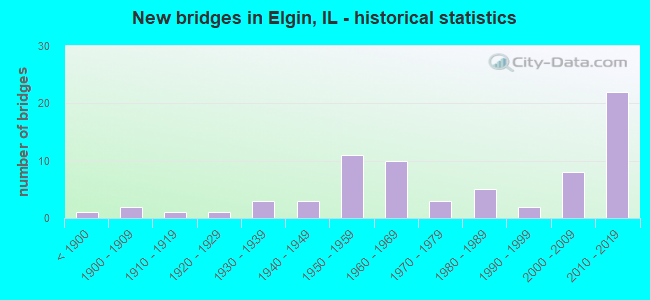
- New bridges - historical statistics
- 1Before 1900
- 21900-1909
- 11910-1919
- 11920-1929
- 31930-1939
- 31940-1949
- 111950-1959
- 101960-1969
- 31970-1979
- 51980-1989
- 21990-1999
- 82000-2009
- 222010-2019
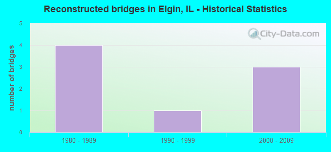
- Reconstructed bridges - Historical Statistics
- 41980-1989
- 11990-1999
- 32000-2009
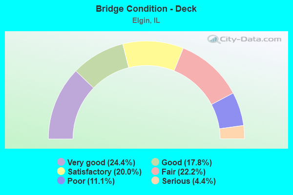
- Bridge Condition - Deck
- 24.4%Very good
- 17.8%Good
- 20.0%Satisfactory
- 22.2%Fair
- 11.1%Poor
- 4.4%Serious
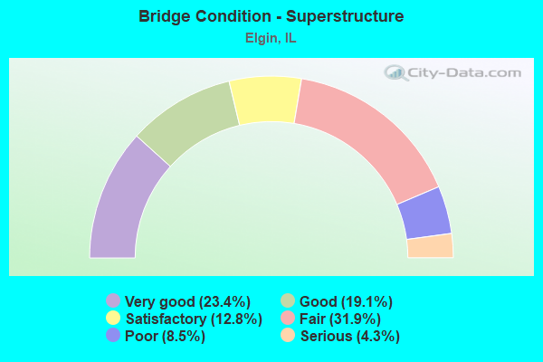
- Bridge Condition - Superstructure
- 23.4%Very good
- 19.1%Good
- 12.8%Satisfactory
- 31.9%Fair
- 8.5%Poor
- 4.3%Serious
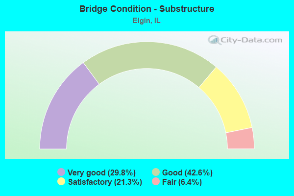
- Bridge Condition - Substructure
- 29.8%Very good
- 42.6%Good
- 21.3%Satisfactory
- 6.4%Fair
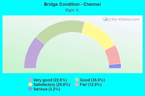
- Bridge Condition - Channel
- 22.6%Very good
- 35.5%Good
- 25.8%Satisfactory
- 12.9%Fair
- 3.2%Serious
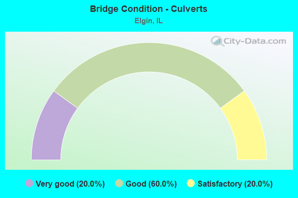
- Bridge Condition - Culverts
- 20.0%Very good
- 60.0%Good
- 20.0%Satisfactory
Find on map >> Show street view
Structure Number: 456301, Location: DOWNTOWN ELGIN (Lat: 42.041528, Lng: -88.290239), Route carried "on" structure: Other road , Year Built: 1917, Year Reconstructed: 1998, Status: Open, Structure Length: 13.62m (44.69ft), Average Daily Traffic: 20,000 (year 2018), Truck Traffic: 3%, Average Future Daily Traffic: 29,986 (year 2032), Design Load: HS 20, Features Intersected: FOX RIVER, Facility Carried by Structure: KIMBALL-ST
Minimum Vertical Clearance: 30+ m (98+ ft), Kilometerpoint: 1.835, Lanes on structure: 5, Base Highway Network: Yes, Owner: City or Municipal Highway Agency, Approaching Roadway Width: 16.8m (55.1ft), Material/Design: Prestressed concrete, Design/Construction: Box Beam or Girders - Multiple, Number Of Spans In Main Unit: 11, Number Of Approach Spans: 2, Length of Maximum Span: 13.7m (44.9ft), Curb or Sidewalk Widths: Left: 0.0m, Right: 2.7m (8.9ft), Curb-To-Curb Width: 18.0m (59.1ft), Out-to-Out Width: 21.5m (70.5ft)
Condition: Deck: Serious, Superstructure: Serious, Substructure: Fair, Channel: Good, Operating Rating: 53.8 metric tons, Method Used To Determine Operating Rating: Load Factor (LF) rating reported by rating factor (RF) method using MS18 loading, Inventory Rating: 32.4 metric tons, Method Used To Determine Inventory Rating: Load Factor (LF) rating reported by rating factor (RF) method using MS18 loading, Structural Evaluation: High priority of corrective action, Deck Geometry: High priority of replacement, Waterway Adequacy: Equal to present desirable criteria, Approach Roadway Alignment: Better than present minimum criteria, Designated Inspection Frequency: Every 24 months, Underwater Inspection Frequency: Every 60 months, Inspection Date: July 2020, Underwater Inspection Date: September 2019, Deck Structure Type: Concrete Precast Panels, Wearing Surface/Protective System: Wearing Surface: Bituminous, Membrane: Built-up
Find on map >> Show street view
Structure Number: 456302, Location: .2MI S BIG TIMBER RD (Lat: 42.089286, Lng: -88.401411), Route carried "on" structure: Other road , Year Built: 2010, Status: Open, Structure Length: 2.30m (7.55ft), Average Daily Traffic: 2,300 (year 2018), Truck Traffic: 4%, Average Future Daily Traffic: 1,340 (year 2032), Design Load: HS 25 or greater, Features Intersected: TYLER CREEK, Facility Carried by Structure: DAMISCH ROAD
Minimum Vertical Clearance: 30+ m (98+ ft), Kilometerpoint: 0.451, Lanes on structure: 2, Owner: City or Municipal Highway Agency, Approaching Roadway Width: 9.1m (29.9ft), Skew: 3 degrees, Material/Design: Prestressed concrete, Design/Construction: Box Beam or Girders - Multiple, Number Of Spans In Main Unit: 1, Length of Maximum Span: 22.2m (72.8ft), Curb-To-Curb Width: 9.1m (29.9ft), Out-to-Out Width: 9.1m (29.9ft)
Condition: Deck: Very good, Superstructure: Very good, Substructure: Very good, Channel: Good, Operating Rating: 53.8 metric tons, Method Used To Determine Operating Rating: Assigned rating based on Load Factor Design (LFD) reported by rating factor (RF) using MS18 loading, Inventory Rating: 32.4 metric tons, Method Used To Determine Inventory Rating: Assigned rating based on Load Factor Design (LFD) reported by rating factor (RF) using MS18 loading, Structural Evaluation: Equal to present desirable criteria, Deck Geometry: Meets minimum limits, Waterway Adequacy: Superior to present desirable criteria, Approach Roadway Alignment: Equal to present desirable criteria, Designated Inspection Frequency: Every 48 months, Inspection Date: September 2020, Deck Structure Type: Concrete Precast Panels, Wearing Surface/Protective System: Wearing Surface: Integral Concrete, Deck Protection: Epoxy Coated Reinforcing
Find on map >> Show street view
Structure Number: 456304, Location: 0.7 MI. N US-20 (Lat: 42.029533, Lng: -88.279633), Route carried "on" structure: Other road , Year Built: 1949, Status: Open, Structure Length: 8.41m (27.59ft), Average Daily Traffic: 6,700 (year 2018), Truck Traffic: 7%, Average Future Daily Traffic: 11,356 (year 2032), Features Intersected: FOX RIVER, Facility Carried by Structure: NATIONAL STREET
Minimum Vertical Clearance: 30+ m (98+ ft), Kilometerpoint: 1.738, Lanes on structure: 2, Base Highway Network: Yes, Owner: City or Municipal Highway Agency, Approaching Roadway Width: 13.4m (44.0ft), Material/Design: Concrete continuous, Design/Construction: Tee Beam, Number Of Spans In Main Unit: 4, Length of Maximum Span: 23.9m (78.4ft), Curb or Sidewalk Widths: Left: 2.4m (7.9ft), Right: 2.4m (7.9ft), Curb-To-Curb Width: 13.4m (44.0ft), Out-to-Out Width: 19.3m (63.3ft)
Condition: Deck: Satisfactory, Superstructure: Fair, Substructure: Satisfactory, Channel: Satisfactory, Operating Rating: 44.1 metric tons, Method Used To Determine Operating Rating: Load Factor (LF) rating reported by rating factor (RF) method using MS18 loading, Inventory Rating: 25.6 metric tons, Method Used To Determine Inventory Rating: Load Factor (LF) rating reported by rating factor (RF) method using MS18 loading, Structural Evaluation: Somewhat better than minimum adequacy, Deck Geometry: Equal to present minimum criteria, Waterway Adequacy: Equal to present desirable criteria, Approach Roadway Alignment: Equal to present minimum criteria, Designated Inspection Frequency: Every 24 months, Underwater Inspection Frequency: Every 60 months, Inspection Date: July 2020, Underwater Inspection Date: September 2019, Deck Structure Type: Concrete Cast-file-Place, Wearing Surface/Protective System: Wearing Surface: Other
Find on map >> Show street view
Structure Number: 456305, Location: .3 MI W MCLEAN BLVD (Lat: 42.046547, Lng: -88.314825), Route carried "on" structure: City street , Year Built: 1967, Status: Open, Structure Length: 0.72m (2.36ft), Average Daily Traffic: 75 (year 2018), Truck Traffic: 11%, Average Future Daily Traffic: 251 (year 2019), Design Load: H 15, Features Intersected: TYLER CREEK, Facility Carried by Structure: EAGLE ROAD
Minimum Vertical Clearance: 30+ m (98+ ft), Kilometerpoint: 0.161, Lanes on structure: 2, Owner: City or Municipal Highway Agency, Approaching Roadway Width: 6.7m (22.0ft), Material/Design: Prestressed concrete, Design/Construction: Box Beam or Girders - Multiple, Number Of Spans In Main Unit: 1, Length of Maximum Span: 6.3m (20.7ft), Curb-To-Curb Width: 7.3m (24.0ft), Out-to-Out Width: 7.9m (25.9ft)
Condition: Deck: Fair, Superstructure: Fair, Substructure: Satisfactory, Channel: Satisfactory, Operating Rating: 33.2 metric tons, Method Used To Determine Operating Rating: Allowable Stress (AS), Inventory Rating: 24.3 metric tons, Method Used To Determine Inventory Rating: Allowable Stress (AS), Structural Evaluation: Somewhat better than minimum adequacy, Deck Geometry: Equal to present minimum criteria, Waterway Adequacy: Better than present minimum criteria, Approach Roadway Alignment: Equal to present desirable criteria, Designated Inspection Frequency: Every 24 months, Inspection Date: July 2020, Deck Structure Type: Concrete Precast Panels, Wearing Surface/Protective System: Wearing Surface: Bituminous
Find on map >> Show street view
Structure Number: 456306, Location: .4 MI W MCLEAN BLVD (Lat: 42.051928, Lng: -88.323286), Route carried "on" structure: City street , Year Built: 1988, Status: Open, Structure Length: 1.09m (3.58ft), Average Daily Traffic: 5,750 (year 2018), Truck Traffic: 6%, Average Future Daily Traffic: 1,200 (year 2032), Design Load: HS 20, Features Intersected: TYLER CREEK, Facility Carried by Structure: ROYAL BOULEVARD
Minimum Vertical Clearance: 30+ m (98+ ft), Kilometerpoint: 1.432, Lanes on structure: 2, Owner: City or Municipal Highway Agency, Approaching Roadway Width: 13.4m (44.0ft), Material/Design: Prestressed concrete, Design/Construction: Box Beam or Girders - Multiple, Number Of Spans In Main Unit: 1, Length of Maximum Span: 10.1m (33.1ft), Curb or Sidewalk Widths: Left: 1.7m (5.6ft), Right: 1.7m (5.6ft), Curb-To-Curb Width: 13.4m (44.0ft), Out-to-Out Width: 17.1m (56.1ft)
Condition: Deck: Fair, Superstructure: Fair, Substructure: Good, Channel: Satisfactory, Operating Rating: 54.1 metric tons, Method Used To Determine Operating Rating: Field evaluation and documented engineering judgment, Inventory Rating: 32.4 metric tons, Method Used To Determine Inventory Rating: Field evaluation and documented engineering judgment, Structural Evaluation: Somewhat better than minimum adequacy, Deck Geometry: Equal to present minimum criteria, Waterway Adequacy: Better than present minimum criteria, Approach Roadway Alignment: Equal to present desirable criteria, Designated Inspection Frequency: Every 24 months, Inspection Date: April 2021, Deck Structure Type: Concrete Precast Panels, Wearing Surface/Protective System: Wearing Surface: Bituminous, Membrane: Other
Find on map >> Show street view
Structure Number: 456307, Location: E BANK FOX RIVER (Lat: 42.037664, Lng: -88.285667), Route carried "on" structure: City street , Year Built: 1972, Status: Open, Structure Length: 7.06m (23.16ft), Average Daily Traffic: 850 (year 2018), Truck Traffic: 4%, Average Future Daily Traffic: 267 (year 2032), Design Load: HS 25 or greater, Features Intersected: PARKING GARAGE, Facility Carried by Structure: RIVERSIDE DRIVE
Minimum Vertical Clearance: 30+ m (98+ ft), Kilometerpoint: 0.032, Lanes on structure: 2, Owner: City or Municipal Highway Agency, Approaching Roadway Width: 6.7m (22.0ft), Material/Design: Prestressed concrete, Design/Construction: Box Beam or Girders - Multiple, Number Of Spans In Main Unit: 5, Length of Maximum Span: 14.9m (48.9ft), Curb or Sidewalk Widths: Left: 3.6m (11.8ft), Right: 3.0m (9.8ft), Curb-To-Curb Width: 6.7m (22.0ft), Out-to-Out Width: 13.7m (44.9ft)
Condition: Deck: Good, Superstructure: Good, Substructure: Good, Operating Rating: 48.3 metric tons, Method Used To Determine Operating Rating: Load and Resistance Factor Rating (LRFR) rating reported by rating factor(RF) method using HL-93 loadings, Inventory Rating: 37.3 metric tons, Method Used To Determine Inventory Rating: Load and Resistance Factor Rating (LRFR) rating reported by rating factor(RF) method using HL-93 loadings, Structural Evaluation: Better than present minimum criteria, Deck Geometry: Meets minimum limits, Approach Roadway Alignment: Equal to present desirable criteria, Designated Inspection Frequency: Every 24 months, Inspection Date: April 2021, Deck Structure Type: Concrete Precast Panels, Wearing Surface/Protective System: Wearing Surface: Integral Concrete, Deck Protection: Epoxy Coated Reinforcing
Find on map >> Show street view
Structure Number: 456312, Location: 0.14 MI SW OF CH34 (Lat: 42.024483, Lng: -88.340950), Route carried "on" structure: City street , Year Built: 2015, Status: Open, Structure Length: 1.05m (3.44ft), Average Daily Traffic: 3,800 (year 2019), Average Future Daily Traffic: 5,738 (year 2038), Design Load: HS 20, Features Intersected: OTTER CREEK, Facility Carried by Structure: SOUTH STREET
Minimum Vertical Clearance: 30+ m (98+ ft), Kilometerpoint: 1.754, Lanes on structure: 2, Owner: City or Municipal Highway Agency, Approaching Roadway Width: 15.5m (50.9ft), Skew: 5 degrees, Material/Design: Concrete, Design/Construction: Culvert, Number Of Spans In Main Unit: 2, Length of Maximum Span: 4.8m (15.7ft), Curb or Sidewalk Widths: Left: 0.0m, Right: 3.0m (9.8ft)
Condition: Channel: Good, Culverts: Good, Operating Rating: 88.8 metric tons, Method Used To Determine Operating Rating: Load Factor (LF) rating reported by rating factor (RF) method using MS18 loading, Inventory Rating: 76.5 metric tons, Method Used To Determine Inventory Rating: Load Factor (LF) rating reported by rating factor (RF) method using MS18 loading, Structural Evaluation: Better than present minimum criteria, Waterway Adequacy: Equal to present desirable criteria, Approach Roadway Alignment: Equal to present desirable criteria, Designated Inspection Frequency: Every 48 months, Inspection Date: April 2021
Find on map >> Show street view
Structure Number: 459909, Location: I90 2.5M W ILL 31 (Lat: 42.080622, Lng: -88.335550), Route carried "on" structure: Other road , Year Built: 1958, Status: Open, Structure Length: 7.49m (24.57ft), Average Daily Traffic: 41,800 (year 2018), Truck Traffic: 6%, Average Future Daily Traffic: 55,378 (year 2032), Design Load: HS 20, Features Intersected: INTERSTATE 90, Facility Carried by Structure: RANDALL ROAD
Minimum Vertical Clearance: 30+ m (98+ ft), Kilometerpoint: 8.079, Lanes on structure: 4, Lanes under structure: 4, Base Highway Network: Yes, Toll: On toll road, Owner: County Highway Agency, Approaching Roadway Width: 24.4m (80.1ft), Skew: 22 degrees, Material/Design: Prestressed concrete, Design/Construction: Stringer/Multi-beam, Number Of Spans In Main Unit: 4, Length of Maximum Span: 22.3m (73.2ft), Curb-To-Curb Width: 22.3m (73.2ft), Out-to-Out Width: 23.4m (76.8ft)
Condition: Deck: Satisfactory, Superstructure: Good, Substructure: Good, Operating Rating: 59.6 metric tons, Method Used To Determine Operating Rating: Load Factor (LF) rating reported by rating factor (RF) method using MS18 loading, Inventory Rating: 35.6 metric tons, Method Used To Determine Inventory Rating: Load Factor (LF) rating reported by rating factor (RF) method using MS18 loading, Structural Evaluation: Better than present minimum criteria, Deck Geometry: Superior to present desirable criteria, Underclear: Equal to present minimum criteria, Approach Roadway Alignment: Equal to present desirable criteria, Designated Inspection Frequency: Every 24 months, Inspection Date: July 2019, Deck Structure Type: Concrete Precast Panels, Wearing Surface/Protective System: Wearing Surface: Other, Deck Protection: Epoxy Coated Reinforcing
Find on map >> Show street view
Structure Number: 45997, Location: .25 MI E RANDALL RD (Lat: 42.072628, Lng: -88.317275), Route carried "on" structure: Interstate 90, Year Built: 2014, Status: Open, Structure Length: 2.59m (8.50ft), Average Daily Traffic: 43,000 (year 2020), Truck Traffic: 16%, Average Future Daily Traffic: 57,548 (year 2032), Design Load: HS 25 or greater, Features Intersected: SLEEPY HOLLOW RD
Minimum Vertical Clearance: 30+ m (98+ ft), Kilometerpoint: 85.663, Lanes on structure: 4, Lanes under structure: 2, Base Highway Network: Yes, Toll: On toll road, Owner: State Toll Authority, Approaching Roadway Width: 23.8m (78.1ft), Skew: 2 degrees, Material/Design: Steel, Design/Construction: Stringer/Multi-beam, Number Of Spans In Main Unit: 1, Length of Maximum Span: 24.1m (79.1ft), Curb-To-Curb Width: 23.8m (78.1ft), Out-to-Out Width: 24.7m (81.0ft)
Condition: Deck: Very good, Superstructure: Very good, Substructure: Very good, Operating Rating: 68.7 metric tons, Method Used To Determine Operating Rating: Load and Resistance Factor Rating (LRFR) rating reported by rating factor(RF) method using HL-93 loadings, Inventory Rating: 52.8 metric tons, Method Used To Determine Inventory Rating: Load and Resistance Factor Rating (LRFR) rating reported by rating factor(RF) method using HL-93 loadings, Structural Evaluation: Equal to present desirable criteria, Deck Geometry: Superior to present desirable criteria, Approach Roadway Alignment: Equal to present desirable criteria, Designated Inspection Frequency: Every 24 months, Inspection Date: August 2020, Deck Structure Type: Concrete Cast-file-Place, Wearing Surface/Protective System: Deck Protection: Other
Find on map >> Show street view
Structure Number: 459971, Location: .25 M E RANDALL RD (Lat: 42.072569, Lng: -88.317108), Route carried "on" structure: Interstate 90, Year Built: 2014, Status: Open, Structure Length: 2.60m (8.53ft), Average Daily Traffic: 43,000 (year 2020), Truck Traffic: 16%, Average Future Daily Traffic: 57,548 (year 2032), Design Load: HS 25 or greater, Features Intersected: SLEEPY HOLLOW RD
Minimum Vertical Clearance: 30+ m (98+ ft), Kilometerpoint: 85.679, Lanes on structure: 4, Lanes under structure: 2, Base Highway Network: Yes, Toll: On toll road, Owner: State Toll Authority, Approaching Roadway Width: 23.8m (78.1ft), Skew: 2 degrees, Material/Design: Steel, Design/Construction: Stringer/Multi-beam, Number Of Spans In Main Unit: 1, Length of Maximum Span: 24.1m (79.1ft), Curb-To-Curb Width: 23.8m (78.1ft), Out-to-Out Width: 24.7m (81.0ft)
Condition: Deck: Very good, Superstructure: Very good, Substructure: Very good, Operating Rating: 68.7 metric tons, Method Used To Determine Operating Rating: Load and Resistance Factor Rating (LRFR) rating reported by rating factor(RF) method using HL-93 loadings, Inventory Rating: 52.8 metric tons, Method Used To Determine Inventory Rating: Load and Resistance Factor Rating (LRFR) rating reported by rating factor(RF) method using HL-93 loadings, Structural Evaluation: Equal to present desirable criteria, Deck Geometry: Superior to present desirable criteria, Approach Roadway Alignment: Equal to present desirable criteria, Designated Inspection Frequency: Every 24 months, Inspection Date: August 2020, Deck Structure Type: Concrete Cast-file-Place, Wearing Surface/Protective System: Deck Protection: Other
Find on map >> Show street view
Structure Number: 459992, Location: 1.5 Mi. W. of IL 25 (Lat: 42.067236, Lng: -88.291831), Route carried "on" structure: Interstate 90, Year Built: 2015, Status: Open, Structure Length: 3.94m (12.93ft), Average Daily Traffic: 43,000 (year 2020), Truck Traffic: 16%, Average Future Daily Traffic: 57,548 (year 2032), Design Load: HS 25 or greater, Features Intersected: Ill. Rte. 31
Minimum Vertical Clearance: 30+ m (98+ ft), Kilometerpoint: 87.884, Lanes on structure: 4, Lanes under structure: 2, Base Highway Network: Yes, Toll: On toll road, Owner: State Toll Authority, Approaching Roadway Width: 27.1m (88.9ft), Material/Design: Prestressed concrete, Design/Construction: Stringer/Multi-beam, Number Of Spans In Main Unit: 1, Length of Maximum Span: 38.3m (125.7ft), Curb-To-Curb Width: 27.1m (88.9ft), Out-to-Out Width: 28.2m (92.5ft)
Condition: Deck: Very good, Superstructure: Very good, Substructure: Very good, Operating Rating: 70.3 metric tons, Method Used To Determine Operating Rating: Load and Resistance Factor Rating (LRFR) rating reported by rating factor(RF) method using HL-93 loadings, Inventory Rating: 54.4 metric tons, Method Used To Determine Inventory Rating: Load and Resistance Factor Rating (LRFR) rating reported by rating factor(RF) method using HL-93 loadings, Structural Evaluation: Equal to present desirable criteria, Deck Geometry: Superior to present desirable criteria, Underclear: High priority of corrective action, Approach Roadway Alignment: Equal to present desirable criteria, Designated Inspection Frequency: Every 24 months, Inspection Date: August 2020, Deck Structure Type: Concrete Cast-file-Place, Wearing Surface/Protective System: Deck Protection: Epoxy Coated Reinforcing
Find on map >> Show street view
Structure Number: 459993, Location: 1.5 Mi W. of Il 25 (Lat: 42.067236, Lng: -88.291831), Route carried "on" structure: Interstate 90, Year Built: 2016, Status: Open, Structure Length: 3.94m (12.93ft), Average Daily Traffic: 43,000 (year 2020), Truck Traffic: 16%, Average Future Daily Traffic: 57,548 (year 2032), Design Load: HS 25 or greater, Features Intersected: Illinois Route 31
Minimum Vertical Clearance: 30+ m (98+ ft), Kilometerpoint: 87.884, Lanes on structure: 4, Lanes under structure: 2, Base Highway Network: Yes, Owner: State Toll Authority, Approaching Roadway Width: 27.1m (88.9ft), Material/Design: Prestressed concrete, Design/Construction: Stringer/Multi-beam, Number Of Spans In Main Unit: 1, Length of Maximum Span: 38.3m (125.7ft), Curb-To-Curb Width: 27.1m (88.9ft), Out-to-Out Width: 28.2m (92.5ft)
Condition: Deck: Very good, Superstructure: Very good, Substructure: Very good, Operating Rating: 82.0 metric tons, Method Used To Determine Operating Rating: Load and Resistance Factor Rating (LRFR) rating reported by rating factor(RF) method using HL-93 loadings, Inventory Rating: 56.4 metric tons, Method Used To Determine Inventory Rating: Load and Resistance Factor Rating (LRFR) rating reported by rating factor(RF) method using HL-93 loadings, Structural Evaluation: Equal to present desirable criteria, Deck Geometry: Superior to present desirable criteria, Approach Roadway Alignment: Equal to present desirable criteria, Designated Inspection Frequency: Every 24 months, Inspection Date: August 2020, Deck Structure Type: Concrete Cast-file-Place, Wearing Surface/Protective System: Deck Protection: Epoxy Coated Reinforcing
Find on map >> Show street view
Structure Number: 459994, Location: 1 Mi. E. Ill. 31 (Lat: 42.066381, Lng: -88.273214), Route carried "on" structure: Interstate 90, Year Built: 2015, Status: Open, Structure Length: 40.10m (131.56ft), Average Daily Traffic: 50,350 (year 2020), Truck Traffic: 16%, Average Future Daily Traffic: 68,968 (year 2032), Design Load: HS 25 or greater, Features Intersected: Fox River/Duncan Ave
Minimum Vertical Clearance: 30+ m (98+ ft), Kilometerpoint: 89.348, Lanes on structure: 4, Lanes under structure: 2, Base Highway Network: Yes, Toll: On toll road, Owner: State Toll Authority, Approaching Roadway Width: 24.4m (80.1ft), Material/Design: Prestressed concrete continuous, Design/Construction: Stringer/Multi-beam, Number Of Spans In Main Unit: 8, Length of Maximum Span: 51.8m (169.9ft), Curb-To-Curb Width: 24.4m (80.1ft), Out-to-Out Width: 25.4m (83.3ft)
Condition: Deck: Very good, Superstructure: Good, Substructure: Good, Channel: Good, Operating Rating: 51.8 metric tons, Method Used To Determine Operating Rating: Load and Resistance Factor Rating (LRFR) rating reported by rating factor(RF) method using HL-93 loadings, Inventory Rating: 35.3 metric tons, Method Used To Determine Inventory Rating: Load and Resistance Factor Rating (LRFR) rating reported by rating factor(RF) method using HL-93 loadings, Structural Evaluation: Better than present minimum criteria, Deck Geometry: Superior to present desirable criteria, Underclear: Meets minimum limits, Waterway Adequacy: Superior to present desirable criteria, Approach Roadway Alignment: Equal to present desirable criteria, Designated Inspection Frequency: Every 24 months, Underwater Inspection Frequency: Every 60 months, Inspection Date: May 2019, Underwater Inspection Date: April 2018, Deck Structure Type: Concrete Cast-file-Place, Wearing Surface/Protective System: Deck Protection: Epoxy Coated Reinforcing
Find on map >> Show street view
Structure Number: 459995, Location: 1 Mi. E. of IL 31 (Lat: 42.066389, Lng: -88.269683), Route carried "on" structure: Interstate 90, Year Built: 2015, Status: Open, Structure Length: 40.10m (131.56ft), Average Daily Traffic: 50,350 (year 2020), Truck Traffic: 16%, Average Future Daily Traffic: 68,968 (year 2032), Design Load: HS 25 or greater, Features Intersected: Fox River/Duncan Ave
Minimum Vertical Clearance: 30+ m (98+ ft), Kilometerpoint: 89.574, Lanes on structure: 4, Lanes under structure: 2, Base Highway Network: Yes, Toll: On toll road, Owner: State Toll Authority, Approaching Roadway Width: 24.4m (80.1ft), Material/Design: Prestressed concrete continuous, Design/Construction: Stringer/Multi-beam, Number Of Spans In Main Unit: 8, Length of Maximum Span: 0.0m, Curb-To-Curb Width: 24.4m (80.1ft), Out-to-Out Width: 25.4m (83.3ft)
Condition: Deck: Very good, Superstructure: Good, Substructure: Good, Channel: Good, Operating Rating: 51.8 metric tons, Method Used To Determine Operating Rating: Load and Resistance Factor Rating (LRFR) rating reported by rating factor(RF) method using HL-93 loadings, Inventory Rating: 35.3 metric tons, Method Used To Determine Inventory Rating: Load and Resistance Factor Rating (LRFR) rating reported by rating factor(RF) method using HL-93 loadings, Structural Evaluation: Better than present minimum criteria, Deck Geometry: Superior to present desirable criteria, Waterway Adequacy: Superior to present desirable criteria, Approach Roadway Alignment: Equal to present desirable criteria, Designated Inspection Frequency: Every 24 months, Underwater Inspection Frequency: Every 60 months, Inspection Date: May 2019, Underwater Inspection Date: April 2018, Deck Structure Type: Concrete Cast-file-Place, Wearing Surface/Protective System: Deck Protection: Epoxy Coated Reinforcing
Find on map >> Show street view
Structure Number: 160218, Location: 1 M E KANE CO (Lat: 42.021367, Lng: -88.247250), Route carried "under" structure: Other road , Year Built: 1961, Structure Length: 0. m, Average Daily Traffic: 5,750 (year 2018), Truck Traffic: 7%, Features Intersected: US 20 VILLA ST, Facility Carried by Structure: US 20 WB
Minimum Vertical Clearance: 4.60m (15.09ft), Kilometerpoint: 1.609, Lanes on structure: 2, Lanes under structure: 3, Material/Design: Steel continuous, Design/Construction: Stringer/Multi-beam, Length of Maximum Span: 19.5m (64.0ft)
Find on map >> Show street view
Structure Number: 169057, Location: 0.25 Mi E. of Il. 25 (Lat: 42.066378, Lng: -88.258392), Route carried "under" structure: Interstate 90, Year Built: 2015, Structure Length: 0. m, Average Daily Traffic: 101,700 (year 2020), Truck Traffic: 26%, Features Intersected: I-90, Facility Carried by Structure: Ill. Rte. 25 Ramp
Minimum Vertical Clearance: 5.11m (16.77ft), Kilometerpoint: 90.700, Lanes on structure: 2, Lanes under structure: 9, Material/Design: Steel continuous, Design/Construction: Stringer/Multi-beam, Length of Maximum Span: 41.8m (137.1ft)
Find on map >> Show street view
Structure Number: 450005, Location: 0.25 M W OF IL 25 (Lat: 42.020150, Lng: -88.272419), Route carried "under" structure: Other road , Year Built: 1960, Structure Length: 0. m, Average Daily Traffic: 4,850 (year 2018), Truck Traffic: 5%, Features Intersected: RAYMOND ST, Facility Carried by Structure: US 20
Minimum Vertical Clearance: 4.37m (14.34ft), Kilometerpoint: 2.977, Lanes on structure: 4, Lanes under structure: 4, Material/Design: Steel continuous, Design/Construction: Stringer/Multi-beam, Length of Maximum Span: 15.2m (49.9ft)
Find on map >> Show street view
Structure Number: 450006, Location: 1 BLOCK W OF IL 25 (Lat: 42.020272, Lng: -88.268519), Route carried "under" structure: City street , Year Built: 1960, Structure Length: 0. m, Average Daily Traffic: 3,250 (year 2018), Truck Traffic: 22%, Features Intersected: ST CHARLES ST, Facility Carried by Structure: US 20
Minimum Vertical Clearance: 4.34m (14.24ft), Kilometerpoint: 0.080, Lanes on structure: 4, Lanes under structure: 4, Material/Design: Steel continuous, Design/Construction: Stringer/Multi-beam, Length of Maximum Span: 24.4m (80.1ft)
Find on map >> Show street view
Structure Number: 450007, Location: US 20 & LIBERTY ST (Lat: 42.020211, Lng: -88.267331), Route carried "under" structure: State highway 25, Year Built: 1959, Structure Length: 0. m, Average Daily Traffic: 14,900 (year 2021), Truck Traffic: 15%, Features Intersected: IL 25 (LIBERTY ST), Facility Carried by Structure: US 20
Minimum Vertical Clearance: 4.42m (14.50ft), Kilometerpoint: 41.858, Lanes on structure: 4, Lanes under structure: 2, Material/Design: Steel continuous, Design/Construction: Stringer/Multi-beam, Length of Maximum Span: 21.0m (68.9ft)
Find on map >> Show street view
Structure Number: 450008, Location: 2.6 M W OF IL 31 (Lat: 42.031478, Lng: -88.336236), Route carried "under" structure: US 20, Year Built: 1961, Structure Length: 0. m, Average Daily Traffic: 28,700 (year 2021), Truck Traffic: 14%, Features Intersected: US 20 WB
Minimum Vertical Clearance: 4.60m (15.09ft), Kilometerpoint: 228.118, Lanes on structure: 1, Lanes under structure: 2, Material/Design: Steel, Design/Construction: Stringer/Multi-beam, Length of Maximum Span: 22.9m (75.1ft)
Find on map >> Show street view
Structure Number: 450017, Location: 3 M S OF I-90 (Lat: 42.021903, Lng: -88.283469), Route carried "under" structure: US 20, Year Built: 1959, Structure Length: 0. m, Average Daily Traffic: 38,100 (year 2021), Truck Traffic: 16%, Features Intersected: US 20 BY PASS, Facility Carried by Structure: IL 31
Minimum Vertical Clearance: 4.57m (14.99ft), Kilometerpoint: 232.544, Lanes on structure: 4, Lanes under structure: 4, Material/Design: Steel, Design/Construction: Stringer/Multi-beam, Length of Maximum Span: 20.5m (67.3ft)
Find on map >> Show street view
Structure Number: 45006, Location: 2.5 M W OF IL 31 (Lat: 42.032325, Lng: -88.338861), Route carried "under" structure: US 20, Year Built: 1961, Structure Length: 0. m, Average Daily Traffic: 28,000 (year 2021), Truck Traffic: 9%, Features Intersected: US 20 BY PASS, Facility Carried by Structure: RANDALL RD
Minimum Vertical Clearance: 4.47m (14.67ft), Kilometerpoint: 227.796, Lanes on structure: 4, Lanes under structure: 6, Material/Design: Steel continuous, Design/Construction: Stringer/Multi-beam, Length of Maximum Span: 24.0m (78.7ft)
Find on map >> Show street view
Structure Number: 450066, Location: 0.1 M W OF ILL 31 (Lat: 42.036792, Lng: -88.288978), Route carried "under" structure: Other road , Year Built: 1893, Structure Length: 0. m, Average Daily Traffic: 9,150 (year 2018), Truck Traffic: 5%, Features Intersected: US 20B (HIGHLAND A), Facility Carried by Structure: CHGO & NW RR
Minimum Vertical Clearance: 5.61m (18.41ft), Kilometerpoint: 4.072, Lanes under structure: 4, Material/Design: Steel, Design/Construction: Girder and Floorbeam System, Length of Maximum Span: 12.8m (42.0ft)
Find on map >> Show street view
Structure Number: 450077, Location: 1.3 M W OF IL 31 (Lat: 42.023350, Lng: -88.312081), Route carried "under" structure: Other road , Year Built: 2015, Structure Length: 0. m, Average Daily Traffic: 25,300 (year 2018), Truck Traffic: 5%, Features Intersected: MCLEAN BLVD, Facility Carried by Structure: US 20
Minimum Vertical Clearance: 4.78m (15.68ft), Kilometerpoint: 9.125, Lanes on structure: 4, Lanes under structure: 4, Material/Design: Steel continuous, Design/Construction: Stringer/Multi-beam, Length of Maximum Span: 76.2m (250.0ft)
Find on map >> Show street view
Structure Number: 450111, Location: 1.5 M E of IL 31 (Lat: 42.066397, Lng: -88.263392), Route carried "under" structure: Interstate 90, Year Built: 2015, Structure Length: 0. m, Average Daily Traffic: 100,700 (year 2021), Truck Traffic: 26%, Features Intersected: I- 90 ADAMS TOLL, Facility Carried by Structure: IL 25
Minimum Vertical Clearance: 5.11m (16.77ft), Kilometerpoint: 90.298, Lanes on structure: 4, Lanes under structure: 6, Material/Design: Prestressed concrete continuous, Design/Construction: Stringer/Multi-beam, Length of Maximum Span: 40.5m (132.9ft)
Find on map >> Show street view
Structure Number: 459007, Location: 0.85 Mi W of Ill 31 (Lat: 42.070103, Lng: -88.306697), Route carried "under" structure: Interstate 90, Year Built: 2006, Structure Length: 0. m, Average Daily Traffic: 86,000 (year 2020), Truck Traffic: 16%, Features Intersected: I-90, Facility Carried by Structure: Pedestrian Walkway
Minimum Vertical Clearance: 7.32m (24.02ft), Kilometerpoint: 86.613, Lanes under structure: 16, Toll: On toll road, Material/Design: Steel continuous, Length of Maximum Span: 36.0m (118.1ft)
Find on map >> Show street view
Structure Number: 459909, Location: I90 2.5M W ILL 31 (Lat: 42.080622, Lng: -88.335550), Route carried "under" structure: Interstate 90, Year Built: 1958, Structure Length: 0. m, Average Daily Traffic: 86,000 (year 2020), Truck Traffic: 16%, Features Intersected: INTERSTATE 90, Facility Carried by Structure: RANDALL ROAD
Minimum Vertical Clearance: 4.62m (15.16ft), Kilometerpoint: 83.973, Lanes on structure: 4, Lanes under structure: 4, Toll: On toll road, Material/Design: Prestressed concrete, Design/Construction: Stringer/Multi-beam, Length of Maximum Span: 22.3m (73.2ft)
Find on map >> Show street view
Structure Number: 45994, Location: 4.2 M W OF ILL 31 (Lat: 42.002469, Lng: -88.370089), Route carried "under" structure: County highway , Year Built: 1900, Structure Length: 0. m, Average Daily Traffic: 3,350 (year 2018), Truck Traffic: 4%, Features Intersected: NOLAN ROAD, Facility Carried by Structure: ILL CENTRAL GULF R
Minimum Vertical Clearance: 4.57m (14.99ft), Kilometerpoint: 0.451, Lanes under structure: 2, Material/Design: Wood or Timber, Length of Maximum Span: 10.7m (35.1ft)
Find on map >> Show street view
Structure Number: 45997, Location: .25 MI E RANDALL RD (Lat: 42.072378, Lng: -88.316939), Route carried "under" structure: Other road , Year Built: 2014, Structure Length: 0. m, Average Daily Traffic: 6,900 (year 2018), Truck Traffic: 3%, Features Intersected: SLEEPY HOLLOW RD, Facility Carried by Structure: I-90
Minimum Vertical Clearance: 4.88m (16.01ft), Kilometerpoint: 3.508, Lanes on structure: 4, Lanes under structure: 2, Toll: On toll road, Material/Design: Steel, Design/Construction: Stringer/Multi-beam, Length of Maximum Span: 24.1m (79.1ft)
Find on map >> Show street view
Structure Number: 459971, Location: .25 M E RANDALL RD (Lat: 42.072747, Lng: -88.316914), Route carried "under" structure: Other road , Year Built: 2014, Structure Length: 0. m, Average Daily Traffic: 6,900 (year 2018), Truck Traffic: 3%, Features Intersected: SLEEPY HOLLOW RD, Facility Carried by Structure: I-90
Minimum Vertical Clearance: 4.88m (16.01ft), Kilometerpoint: 3.476, Lanes on structure: 4, Lanes under structure: 2, Toll: On toll road, Material/Design: Steel, Design/Construction: Stringer/Multi-beam, Length of Maximum Span: 24.1m (79.1ft)
Find on map >> Show street view
Structure Number: 459992, Location: 1.5 Mi. W. of IL 25 (Lat: 42.067389, Lng: -88.291494), Route carried "under" structure: State highway 31, Year Built: 2015, Structure Length: 0. m, Average Daily Traffic: 22,400 (year 2021), Truck Traffic: 8%, Features Intersected: Ill. Rte. 31, Facility Carried by Structure: I-90 (WB)
Minimum Vertical Clearance: 4.67m (15.32ft), Kilometerpoint: 47.555, Lanes on structure: 4, Lanes under structure: 2, Toll: On toll road, Material/Design: Prestressed concrete, Design/Construction: Stringer/Multi-beam, Length of Maximum Span: 38.3m (125.7ft)
Find on map >> Show street view
Structure Number: 459993, Location: 1.5 Mi W. of Il 25 (Lat: 42.067158, Lng: -88.291533), Route carried "under" structure: State highway 31, Year Built: 2016, Structure Length: 0. m, Average Daily Traffic: 22,000 (year 2021), Truck Traffic: 11%, Features Intersected: Illinois Route 31, Facility Carried by Structure: I-90 (EB)
Minimum Vertical Clearance: 4.67m (15.32ft), Kilometerpoint: 47.539, Lanes on structure: 4, Lanes under structure: 2, Material/Design: Prestressed concrete, Design/Construction: Stringer/Multi-beam, Length of Maximum Span: 38.3m (125.7ft)
Find on map >> Show street view
Structure Number: 459994, Location: 1 Mi. E. Ill. 31 (Lat: 42.066558, Lng: -88.269414), Route carried "under" structure: Other road , Year Built: 2015, Structure Length: 0. m, Average Daily Traffic: 2,050 (year 2018), Truck Traffic: 5%, Features Intersected: Fox River/Duncan Ave, Facility Carried by Structure: I-90 (EB)
Minimum Vertical Clearance: 10.67m (35.01ft), Kilometerpoint: 5.649, Lanes on structure: 4, Lanes under structure: 2, Toll: On toll road, Material/Design: Prestressed concrete continuous, Design/Construction: Stringer/Multi-beam, Length of Maximum Span: 51.8m (169.9ft)
Find on map >> Show street view
Structure Number: 459995, Location: 1 Mi. E. of IL 31 (Lat: 42.066389, Lng: -88.269439), Route carried "under" structure: Other road , Year Built: 2015, Structure Length: 0. m, Average Daily Traffic: 2,050 (year 2018), Truck Traffic: 5%, Features Intersected: Fox River/Duncan Ave, Facility Carried by Structure: I-90 (WB)
Minimum Vertical Clearance: 10.67m (35.01ft), Kilometerpoint: 5.665, Lanes on structure: 4, Lanes under structure: 2, Toll: On toll road, Material/Design: Prestressed concrete continuous, Design/Construction: Stringer/Multi-beam, Length of Maximum Span: 0.0m