Bridge Statistics for Elizabethtown, Pennsylvania (PA)
Condition, Traffic, Stress, Structural Evaluation, Project Costs
- National Bridge Inventory (NBI) Statistics
- 68Number of bridges
- 413ft / 126mTotal length
- $7,549,000Total costs
- 665,752Total average daily traffic
- 89,989Total average daily truck traffic
- National Bridge Inventory (NBI) Registered Bridges for Elizabethtown
- No street view available for this location
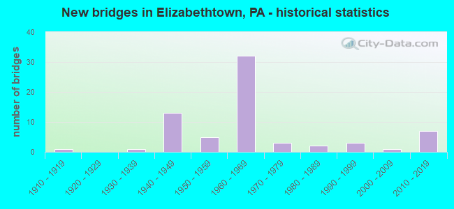
- New bridges - historical statistics
- 11910-1919
- 11930-1939
- 131940-1949
- 51950-1959
- 321960-1969
- 31970-1979
- 21980-1989
- 31990-1999
- 12000-2009
- 72010-2019
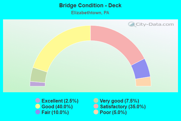
- Bridge Condition - Deck
- 2.5%Excellent
- 7.5%Very good
- 40.0%Good
- 35.0%Satisfactory
- 10.0%Fair
- 5.0%Poor
- Bridge Condition - Superstructure
- 7.0%Excellent
- 11.6%Very good
- 9.3%Good
- 34.9%Satisfactory
- 30.2%Fair
- 2.3%Poor
- 2.3%Serious
- 2.3%Failed
- Bridge Condition - Substructure
- 11.6%Very good
- 23.3%Good
- 37.2%Satisfactory
- 20.9%Fair
- 7.0%Poor
- Bridge Condition - Channel
- 20.8%Good
- 33.3%Satisfactory
- 29.2%Fair
- 16.7%Poor
Find on map >> Show street view
Structure Number: 48997, Location: 0.5 MI SOUTH OF SR 230 (Lat: 40.151392, Lng: -76.630164), Route carried "on" structure: City street T310, Year Built: 2015, Status: Open, Structure Length: 3.72m (12.20ft), Average Daily Traffic: 300 (year 2010), Truck Traffic: 3%, Average Future Daily Traffic: 351 (year 2030), Design Load: HL 93, Features Intersected: AMTRAK, Facility Carried by Structure: T-328 NEWVILLE RD
Minimum Vertical Clearance: 30+ m (98+ ft), Kilometerpoint: 0.000, Lanes on structure: 2, Owner: Town or Township Highway Agency, Approaching Roadway Width: 6.7m (22.0ft), Material/Design: Prestressed concrete continuous, Design/Construction: Box Beam or Girders - Single/Spread, Number Of Spans In Main Unit: 3, Length of Maximum Span: 15.2m (49.9ft), Curb or Sidewalk Widths: Left: 0.2m (0.7ft), Right: 0.2m (0.7ft), Curb-To-Curb Width: 8.6m (28.2ft), Out-to-Out Width: 9.6m (31.5ft)
Condition: Deck: Good, Superstructure: Excellent, Substructure: Very good, Operating Rating: 61.6 metric tons, Method Used To Determine Operating Rating: Assigned ratings based on Load and Resistance Factor Design (LRFD) reported by rating factor (RF) using HL93 loadings, Inventory Rating: 34.3 metric tons, Method Used To Determine Inventory Rating: Assigned ratings based on Load and Resistance Factor Design (LRFD) reported by rating factor (RF) using HL93 loadings, Structural Evaluation: Equal to present desirable criteria, Deck Geometry: Equal to present minimum criteria, Underclear: High priority of corrective action, Approach Roadway Alignment: Better than present minimum criteria, Designated Inspection Frequency: Every 24 months, Inspection Date: November 2019, Deck Structure Type: Concrete Cast-file-Place, Wearing Surface/Protective System: Wearing Surface: Monolithic Concrete, Deck Protection: Epoxy Coated Reinforcing
Find on map >> Show street view
Structure Number: 53339, Location: 900 ft from W Bainbr. ST (Lat: 40.143122, Lng: -76.606175), Route carried "on" structure: City street 407, Year Built: 2014, Status: Open, Structure Length: 3.32m (10.89ft), Average Daily Traffic: 870 (year 2018), Average Future Daily Traffic: 1,062 (year 2038), Design Load: HL 93, Features Intersected: Conoy Creek, Facility Carried by Structure: Masonic Drive
Minimum Vertical Clearance: 30+ m (98+ ft), Kilometerpoint: 0.000, Lanes on structure: 2, Owner: Town or Township Highway Agency, Approaching Roadway Width: 11.0m (36.1ft), Skew: 3 degrees, Material/Design: Prestressed concrete, Design/Construction: Stringer/Multi-beam, Number Of Spans In Main Unit: 1, Length of Maximum Span: 32.3m (106.0ft), Curb or Sidewalk Widths: Left: 1.4m (4.6ft), Right: 1.4m (4.6ft), Curb-To-Curb Width: 11.0m (36.1ft), Out-to-Out Width: 14.4m (47.2ft)
Condition: Deck: Excellent, Superstructure: Excellent, Substructure: Good, Channel: Fair, Operating Rating: 65.4 metric tons, Method Used To Determine Operating Rating: Assigned ratings based on Load and Resistance Factor Design (LRFD) reported by rating factor (RF) using HL93 loadings, Inventory Rating: 36.6 metric tons, Method Used To Determine Inventory Rating: Assigned ratings based on Load and Resistance Factor Design (LRFD) reported by rating factor (RF) using HL93 loadings, Structural Evaluation: Better than present minimum criteria, Deck Geometry: Better than present minimum criteria, Waterway Adequacy: Superior to present desirable criteria, Approach Roadway Alignment: Equal to present desirable criteria, Designated Inspection Frequency: Every 24 months, Inspection Date: July 2020, Deck Structure Type: Concrete Cast-file-Place, Wearing Surface/Protective System: Wearing Surface: Monolithic Concrete, Deck Protection: Epoxy Coated Reinforcing
Find on map >> Show street view
Structure Number: 54169, Location: MT JOY TP-DAUPHIN CO LINE (Lat: 40.188964, Lng: -76.603675), Route carried "on" structure: State highway 743, Year Built: 2016, Status: Open, Structure Length: 4.11m (13.48ft), Average Daily Traffic: 14,657 (year 2021), Truck Traffic: 5%, Average Future Daily Traffic: 15,651 (year 2032), Design Load: HL 93, Features Intersected: CONEWAGO CREEK
Minimum Vertical Clearance: 30+ m (98+ ft), Kilometerpoint: 12.920, Lanes on structure: 2, Base Highway Network: Yes, Owner: State Highway Agency, Approaching Roadway Width: 11.3m (37.1ft), Skew: 1 degrees, Material/Design: Prestressed concrete continuous, Design/Construction: Stringer/Multi-beam, Number Of Spans In Main Unit: 2, Length of Maximum Span: 20.1m (65.9ft), Curb or Sidewalk Widths: Left: 0.2m (0.7ft), Right: 0.2m (0.7ft), Curb-To-Curb Width: 11.3m (37.1ft), Out-to-Out Width: 12.3m (40.4ft)
Condition: Deck: Good, Superstructure: Very good, Substructure: Very good, Channel: Good, Operating Rating: 46.0 metric tons, Method Used To Determine Operating Rating: Assigned ratings based on Load and Resistance Factor Design (LRFD) reported by rating factor (RF) using HL93 loadings, Inventory Rating: 35.6 metric tons, Method Used To Determine Inventory Rating: Assigned ratings based on Load and Resistance Factor Design (LRFD) reported by rating factor (RF) using HL93 loadings, Structural Evaluation: Equal to present desirable criteria, Deck Geometry: Meets minimum limits, Waterway Adequacy: Better than present minimum criteria, Approach Roadway Alignment: Equal to present desirable criteria, Designated Inspection Frequency: Every 24 months, Inspection Date: June 2021, Deck Structure Type: Concrete Cast-file-Place, Wearing Surface/Protective System: Wearing Surface: Monolithic Concrete, Membrane: Other, Deck Protection: Epoxy Coated Reinforcing
Find on map >> Show street view
Structure Number: 54546, Location: 1 MI. S.W. OF ETOWN (Lat: 40.123644, Lng: -76.629889), Route carried "on" structure: State highway 241, Year Built: 2017, Status: Open, Structure Length: 1.19m (3.90ft), Average Daily Traffic: 5,415 (year 2021), Truck Traffic: 5%, Average Future Daily Traffic: 7,215 (year 2032), Design Load: HL 93, Features Intersected: CONOY CREEK
Minimum Vertical Clearance: 30+ m (98+ ft), Kilometerpoint: 3.885, Lanes on structure: 2, Owner: State Highway Agency, Approaching Roadway Width: 9.8m (32.2ft), Material/Design: Prestressed concrete, Design/Construction: Box Beam or Girders - Multiple, Number Of Spans In Main Unit: 1, Length of Maximum Span: 11.6m (38.1ft), Curb-To-Curb Width: 10.1m (33.1ft), Out-to-Out Width: 11.1m (36.4ft)
Condition: Deck: Very good, Superstructure: Very good, Substructure: Very good, Channel: Good, Operating Rating: 48.9 metric tons, Method Used To Determine Operating Rating: Assigned ratings based on Load and Resistance Factor Design (LRFD) reported by rating factor (RF) using HL93 loadings, Inventory Rating: 37.9 metric tons, Method Used To Determine Inventory Rating: Assigned ratings based on Load and Resistance Factor Design (LRFD) reported by rating factor (RF) using HL93 loadings, Structural Evaluation: Equal to present desirable criteria, Deck Geometry: Meets minimum limits, Waterway Adequacy: Equal to present desirable criteria, Approach Roadway Alignment: Equal to present desirable criteria, Designated Inspection Frequency: Every 24 months, Inspection Date: September 2020, Deck Structure Type: Concrete Cast-file-Place, Wearing Surface/Protective System: Wearing Surface: Monolithic Concrete, Deck Protection: Epoxy Coated Reinforcing
Find on map >> Show street view
Structure Number: 54554, Location: 0.75 MI.SW ELIZABETHTOWN (Lat: 40.134853, Lng: -76.616406), Route carried "on" structure: State highway 241, Year Built: 2017, Status: Open, Structure Length: 2.74m (8.99ft), Average Daily Traffic: 5,415 (year 2021), Truck Traffic: 5%, Average Future Daily Traffic: 7,215 (year 2032), Design Load: HL 93, Features Intersected: Conoy Creek
Minimum Vertical Clearance: 30+ m (98+ ft), Kilometerpoint: 6.045, Lanes on structure: 2, Owner: State Highway Agency, Approaching Roadway Width: 7.0m (23.0ft), Skew: 6 degrees, Material/Design: Prestressed concrete, Design/Construction: Box Beam or Girders - Single/Spread, Number Of Spans In Main Unit: 1, Length of Maximum Span: 25.3m (83.0ft), Curb or Sidewalk Widths: Left: 0.2m (0.7ft), Right: 0.2m (0.7ft), Curb-To-Curb Width: 11.3m (37.1ft), Out-to-Out Width: 12.3m (40.4ft)
Condition: Deck: Good, Superstructure: Very good, Substructure: Good, Channel: Good, Operating Rating: 50.2 metric tons, Method Used To Determine Operating Rating: Assigned ratings based on Load and Resistance Factor Design (LRFD) reported by rating factor (RF) using HL93 loadings, Inventory Rating: 38.9 metric tons, Method Used To Determine Inventory Rating: Assigned ratings based on Load and Resistance Factor Design (LRFD) reported by rating factor (RF) using HL93 loadings, Structural Evaluation: Better than present minimum criteria, Deck Geometry: Meets minimum limits, Waterway Adequacy: Equal to present desirable criteria, Approach Roadway Alignment: Equal to present desirable criteria, Designated Inspection Frequency: Every 48 months, Inspection Date: June 2021, Deck Structure Type: Concrete Cast-file-Place, Wearing Surface/Protective System: Wearing Surface: Monolithic Concrete, Deck Protection: Epoxy Coated Reinforcing
Find on map >> Show street view
Structure Number: 57603, Location: 0.4 MI N OF E. HIGH ST (Lat: 40.164264, Lng: -76.591269), Route carried "on" structure: City street , Year Built: 1990, Status: Open, Structure Length: 0.88m (2.89ft), Average Daily Traffic: 800 (year 2020), Average Future Daily Traffic: 900 (year 2040), Features Intersected: CONOY CREEK, Facility Carried by Structure: RADIO RD
Minimum Vertical Clearance: 30+ m (98+ ft), Kilometerpoint: 0.000, Lanes on structure: 2, Owner: City or Municipal Highway Agency, Approaching Roadway Width: 10.1m (33.1ft), Material/Design: Concrete, Design/Construction: Culvert, Number Of Spans In Main Unit: 2, Length of Maximum Span: 3.7m (12.1ft), Curb or Sidewalk Widths: Left: 1.8m (5.9ft), Right: 1.8m (5.9ft), Curb-To-Curb Width: 10.3m (33.8ft), Out-to-Out Width: 14.6m (47.9ft)
Condition: Channel: Fair, Culverts: Satisfactory, Operating Rating: 57.2 metric tons, Method Used To Determine Operating Rating: Field evaluation and documented engineering judgment, Inventory Rating: 33.6 metric tons, Method Used To Determine Inventory Rating: Field evaluation and documented engineering judgment, Structural Evaluation: Equal to present minimum criteria, Deck Geometry: Equal to present minimum criteria, Waterway Adequacy: Better than present minimum criteria, Approach Roadway Alignment: Equal to present desirable criteria, Designated Inspection Frequency: Every 24 months, Inspection Date: May 2020, Wearing Surface/Protective System: Wearing Surface: Bituminous
Find on map >> Show street view
Structure Number: 14361, Location: 5.5 MI. E. OF MIDDLETOWN (Lat: 40.191789, Lng: -76.628950), Route carried "under" structure: City street , Year Built: 1968, Structure Length: 0. m, Average Daily Traffic: 1 (year 2004), Features Intersected: TWP.RD.564; MILL RD., Facility Carried by Structure: PA 283 EB; SR 0300
Minimum Vertical Clearance: 4.39m (14.40ft), Kilometerpoint: 0.000, Lanes on structure: 2, Lanes under structure: 2, Material/Design: Prestressed concrete, Design/Construction: Box Beam or Girders - Single/Spread, Length of Maximum Span: 13.7m (44.9ft)
Find on map >> Show street view
Structure Number: 14362, Location: 5 MI E. MIDDLETOWN (Lat: 40.192361, Lng: -76.629306), Route carried "under" structure: City street , Year Built: 1968, Structure Length: 0. m, Average Daily Traffic: 1 (year 2004), Features Intersected: TWP RD 564, Facility Carried by Structure: PA 283 WB; SR 0300
Minimum Vertical Clearance: 4.42m (14.50ft), Kilometerpoint: 0.000, Lanes on structure: 2, Lanes under structure: 2, Material/Design: Prestressed concrete, Design/Construction: Box Beam or Girders - Single/Spread, Length of Maximum Span: 13.7m (44.9ft)
Find on map >> Show street view
Structure Number: 14363, Location: 6 MI. E. OF MIDDLETOWN (Lat: 40.187703, Lng: -76.614125), Route carried "under" structure: City street , Year Built: 1968, Structure Length: 0. m, Average Daily Traffic: 1 (year 2004), Features Intersected: TWP RD 602, Facility Carried by Structure: PA 283 EB; SR 0300
Minimum Vertical Clearance: 4.47m (14.67ft), Kilometerpoint: 0.000, Lanes on structure: 2, Lanes under structure: 2, Material/Design: Prestressed concrete, Design/Construction: Box Beam or Girders - Single/Spread, Length of Maximum Span: 17.4m (57.1ft)
Find on map >> Show street view
Structure Number: 14365, Location: 6 MI. E. MIDDLETOWN (Lat: 40.188200, Lng: -76.614367), Route carried "under" structure: City street , Year Built: 1968, Structure Length: 0. m, Average Daily Traffic: 1 (year 2004), Features Intersected: TWP RD 602, Facility Carried by Structure: PA 283 WB; SR 0300
Minimum Vertical Clearance: 4.52m (14.83ft), Kilometerpoint: 0.000, Lanes on structure: 2, Lanes under structure: 2, Material/Design: Prestressed concrete, Design/Construction: Box Beam or Girders - Single/Spread, Length of Maximum Span: 17.4m (57.1ft)
Find on map >> Show street view
Structure Number: 14471, Location: 4 MI. E. MIDDLETOWN (Lat: 40.194425, Lng: -76.651961), Route carried "under" structure: State highway 283, Year Built: 1969, Structure Length: 0. m, Average Daily Traffic: 20,232 (year 2021), Truck Traffic: 10%, Features Intersected: SR 0300, Facility Carried by Structure: SR 2007 DEODATE RD
Minimum Vertical Clearance: 4.52m (14.83ft), Kilometerpoint: 13.876, Lanes on structure: 2, Lanes under structure: 4, Material/Design: Prestressed concrete, Design/Construction: Stringer/Multi-beam, Length of Maximum Span: 32.3m (106.0ft)
Find on map >> Show street view
Structure Number: 14471, Location: 4 MI. E. MIDDLETOWN (Lat: 40.194425, Lng: -76.651961), Route carried "under" structure: State highway 283, Year Built: 1969, Structure Length: 0. m, Average Daily Traffic: 21,609 (year 2021), Truck Traffic: 10%, Features Intersected: SR 0300, Facility Carried by Structure: SR 2007 DEODATE RD
Minimum Vertical Clearance: 4.52m (14.83ft), Kilometerpoint: 13.924, Lanes on structure: 2, Lanes under structure: 4, Material/Design: Prestressed concrete, Design/Construction: Stringer/Multi-beam, Length of Maximum Span: 32.3m (106.0ft)
Find on map >> Show street view
Structure Number: 14622, Location: CONEWAGO TWP (Lat: 40.203333, Lng: -76.633333), Route carried "under" structure: State highway , Year Built: 1949, Structure Length: 0. m, Average Daily Traffic: 1,180 (year 2022), Truck Traffic: 4%, Features Intersected: LR22009,SR2007, Facility Carried by Structure: PA TPK (I-76)
Minimum Vertical Clearance: 4.62m (15.16ft), Kilometerpoint: 5.718, Lanes on structure: 2, Lanes under structure: 2, Material/Design: Concrete, Design/Construction: Tee Beam, Length of Maximum Span: 10.7m (35.1ft)
Find on map >> Show street view
Structure Number: 14623, Location: CONEWAGO TWP (Lat: 40.205000, Lng: -76.620000), Route carried "under" structure: Interstate 76, Year Built: 1949, Structure Length: 0. m, Average Daily Traffic: 24,423 (year 2001), Truck Traffic: 24%, Features Intersected: PA TPK (I-76), Facility Carried by Structure: T-602
Minimum Vertical Clearance: 4.51m (14.80ft), Kilometerpoint: 0.000, Lanes on structure: 2, Lanes under structure: 4, Material/Design: Steel, Design/Construction: Girder and Floorbeam System, Length of Maximum Span: 27.1m (88.9ft)
Find on map >> Show street view
Structure Number: 14624, Location: CONEWAGO TWP (Lat: 40.208972, Lng: -76.613583), Route carried "under" structure: State highway 743, Year Built: 1949, Structure Length: 0. m, Average Daily Traffic: 14,657 (year 2021), Truck Traffic: 5%, Features Intersected: LR22007, PA 743, Facility Carried by Structure: PA TPK (I-76)
Minimum Vertical Clearance: 4.67m (15.32ft), Kilometerpoint: 2.284, Lanes on structure: 4, Lanes under structure: 2, Material/Design: Concrete, Design/Construction: Frame, Length of Maximum Span: 12.5m (41.0ft)
Find on map >> Show street view
Structure Number: 14626, Location: CONEWAGO TWP (Lat: 40.205000, Lng: -76.590000), Route carried "under" structure: City street , Year Built: 1949, Structure Length: 0. m, Average Daily Traffic: 100 (year 1991), Features Intersected: T-570, Facility Carried by Structure: PA TPK (I-76)
Minimum Vertical Clearance: 4.23m (13.88ft), Kilometerpoint: 0.000, Lanes on structure: 4, Lanes under structure: 2, Toll: On toll road, Material/Design: Concrete, Design/Construction: Tee Beam, Length of Maximum Span: 6.7m (22.0ft)
Find on map >> Show street view
Structure Number: 14627, Location: CONEWAGO TOWNSHIP (Lat: 40.207503, Lng: -76.581172), Route carried "under" structure: Interstate 76, Year Built: 1950, Structure Length: 0. m, Average Daily Traffic: 23,988 (year 1999), Truck Traffic: 22%, Features Intersected: PA TPK (I-76), Facility Carried by Structure: LR 22010,SR2009
Minimum Vertical Clearance: 4.54m (14.90ft), Kilometerpoint: 0.000, Lanes on structure: 2, Lanes under structure: 4, Material/Design: Concrete, Design/Construction: Frame, Length of Maximum Span: 25.6m (84.0ft)
Find on map >> Show street view
Structure Number: 21135, Location: N OF ETOWN BORO-MT JOY TP (Lat: 40.174092, Lng: -76.595961), Route carried "under" structure: State highway 283, Year Built: 1968, Structure Length: 0. m, Average Daily Traffic: 20,391 (year 2020), Truck Traffic: 15%, Features Intersected: SR 0300 AND RAMP P;PA283, Facility Carried by Structure: PA 241; SR 0241
Minimum Vertical Clearance: 6.60m (21.65ft), Kilometerpoint: 1.654, Lanes on structure: 2, Lanes under structure: 3, Material/Design: Prestressed concrete, Design/Construction: Stringer/Multi-beam, Length of Maximum Span: 29.3m (96.1ft)
Find on map >> Show street view
Structure Number: 21135, Location: N OF ETOWN BORO-MT JOY TP (Lat: 40.174092, Lng: -76.595961), Route carried "under" structure: State highway 283, Year Built: 1968, Structure Length: 0. m, Average Daily Traffic: 20,906 (year 2020), Truck Traffic: 15%, Features Intersected: SR 0300 AND RAMP P;PA283, Facility Carried by Structure: PA 241; SR 0241
Minimum Vertical Clearance: 6.60m (21.65ft), Kilometerpoint: 1.656, Lanes on structure: 2, Lanes under structure: 2, Material/Design: Prestressed concrete, Design/Construction: Stringer/Multi-beam, Length of Maximum Span: 29.3m (96.1ft)
Find on map >> Show street view
Structure Number: 21163, Location: 1/2 MI. E. OF CONEWAGO CR (Lat: 40.182439, Lng: -76.606808), Route carried "under" structure: City street , Year Built: 1968, Structure Length: 0. m, Average Daily Traffic: 1 (year 2003), Features Intersected: T-871; BEVERLY RD., Facility Carried by Structure: PA 283 EB; SR 0300
Minimum Vertical Clearance: 4.47m (14.67ft), Kilometerpoint: 0.000, Lanes on structure: 2, Lanes under structure: 2, Material/Design: Prestressed concrete, Design/Construction: Box Beam or Girders - Single/Spread, Length of Maximum Span: 10.4m (34.1ft)
Find on map >> Show street view
Structure Number: 21165, Location: 1/2 MI. E. OF CONEWAGO CR (Lat: 40.182547, Lng: -76.606511), Route carried "under" structure: City street , Year Built: 1968, Structure Length: 0. m, Average Daily Traffic: 1 (year 2003), Features Intersected: BEVERLY RD; T-871, Facility Carried by Structure: PA 283 WB; SR 0300
Minimum Vertical Clearance: 4.45m (14.60ft), Kilometerpoint: 0.000, Lanes on structure: 2, Lanes under structure: 2, Material/Design: Prestressed concrete, Design/Construction: Box Beam or Girders - Single/Spread, Length of Maximum Span: 10.4m (34.1ft)
Find on map >> Show street view
Structure Number: 21166, Location: N. OF ELIZABETHTOWN (Lat: 40.178097, Lng: -76.601161), Route carried "under" structure: State highway 743, Year Built: 1968, Structure Length: 0. m, Average Daily Traffic: 6,465 (year 2021), Truck Traffic: 5%, Features Intersected: PA 743; SR 0743, Facility Carried by Structure: PA 283 EB; SR 0300
Minimum Vertical Clearance: 4.66m (15.29ft), Kilometerpoint: 11.824, Lanes on structure: 2, Lanes under structure: 4, Material/Design: Prestressed concrete, Design/Construction: Stringer/Multi-beam, Length of Maximum Span: 31.1m (102.0ft)
Find on map >> Show street view
Structure Number: 21166, Location: N. OF ELIZABETHTOWN (Lat: 40.178097, Lng: -76.601161), Route carried "under" structure: State highway 743, Year Built: 1968, Structure Length: 0. m, Average Daily Traffic: 6,465 (year 2021), Truck Traffic: 5%, Features Intersected: PA 743; SR 0743, Facility Carried by Structure: PA 283 EB; SR 0300
Minimum Vertical Clearance: 4.45m (14.60ft), Kilometerpoint: 11.824, Lanes on structure: 2, Lanes under structure: 4, Material/Design: Prestressed concrete, Design/Construction: Stringer/Multi-beam, Length of Maximum Span: 31.1m (102.0ft)
Find on map >> Show street view
Structure Number: 21167, Location: N. OF ELIZABETHTOWN (Lat: 40.178272, Lng: -76.600958), Route carried "under" structure: State highway 743, Year Built: 1968, Structure Length: 0. m, Average Daily Traffic: 6,465 (year 2021), Truck Traffic: 5%, Features Intersected: PA 743; SR 0743, Facility Carried by Structure: PA 283 WB; SR 0300
Minimum Vertical Clearance: 4.57m (14.99ft), Kilometerpoint: 11.824, Lanes on structure: 2, Lanes under structure: 4, Material/Design: Prestressed concrete, Design/Construction: Stringer/Multi-beam, Length of Maximum Span: 31.1m (102.0ft)
Find on map >> Show street view
Structure Number: 21167, Location: N. OF ELIZABETHTOWN (Lat: 40.178272, Lng: -76.600958), Route carried "under" structure: State highway 743, Year Built: 1968, Structure Length: 0. m, Average Daily Traffic: 6,465 (year 2021), Truck Traffic: 5%, Features Intersected: PA 743; SR 0743, Facility Carried by Structure: PA 283 WB; SR 0300
Minimum Vertical Clearance: 4.85m (15.91ft), Kilometerpoint: 11.824, Lanes on structure: 2, Lanes under structure: 4, Material/Design: Prestressed concrete, Design/Construction: Stringer/Multi-beam, Length of Maximum Span: 31.1m (102.0ft)
Find on map >> Show street view
Structure Number: 21169, Location: 1 MI.N.E. ELIZABETHTOWN (Lat: 40.155322, Lng: -76.571414), Route carried "under" structure: State highway 283, Year Built: 1969, Structure Length: 0. m, Average Daily Traffic: 20,906 (year 2020), Truck Traffic: 15%, Features Intersected: PA 283; SR 0300, Facility Carried by Structure: SR 4041 Ridge Rd.
Minimum Vertical Clearance: 4.52m (14.83ft), Kilometerpoint: 4.838, Lanes on structure: 2, Lanes under structure: 4, Material/Design: Prestressed concrete, Design/Construction: Box Beam or Girders - Single/Spread, Length of Maximum Span: 20.1m (65.9ft)
Find on map >> Show street view
Structure Number: 21169, Location: 1 MI.N.E. ELIZABETHTOWN (Lat: 40.155322, Lng: -76.571414), Route carried "under" structure: State highway 283, Year Built: 1969, Structure Length: 0. m, Average Daily Traffic: 20,391 (year 2020), Truck Traffic: 15%, Features Intersected: PA 283; SR 0300, Facility Carried by Structure: SR 4041 Ridge Rd.
Minimum Vertical Clearance: 4.52m (14.83ft), Kilometerpoint: 4.843, Lanes on structure: 2, Lanes under structure: 4, Material/Design: Prestressed concrete, Design/Construction: Box Beam or Girders - Single/Spread, Length of Maximum Span: 20.1m (65.9ft)
Find on map >> Show street view
Structure Number: 21691, Location: N OF ELIZABETHTOWN BORO (Lat: 40.162856, Lng: -76.581375), Route carried "under" structure: State highway 283, Year Built: 1968, Structure Length: 0. m, Average Daily Traffic: 20,391 (year 2020), Truck Traffic: 15%, Features Intersected: PA 283; SR 0300, Facility Carried by Structure: SR 4008 E-Town Rd
Minimum Vertical Clearance: 5.13m (16.83ft), Kilometerpoint: 3.235, Lanes on structure: 2, Lanes under structure: 4, Material/Design: Prestressed concrete, Design/Construction: Stringer/Multi-beam, Length of Maximum Span: 31.7m (104.0ft)
Find on map >> Show street view
Structure Number: 21691, Location: N OF ELIZABETHTOWN BORO (Lat: 40.162856, Lng: -76.581375), Route carried "under" structure: State highway 283, Year Built: 1968, Structure Length: 0. m, Average Daily Traffic: 20,906 (year 2020), Truck Traffic: 15%, Features Intersected: PA 283; SR 0300, Facility Carried by Structure: SR 4008 E-Town Rd
Minimum Vertical Clearance: 5.13m (16.83ft), Kilometerpoint: 3.233, Lanes on structure: 2, Lanes under structure: 4, Material/Design: Prestressed concrete, Design/Construction: Stringer/Multi-beam, Length of Maximum Span: 31.7m (104.0ft)
Find on map >> Show street view
Structure Number: 22824, Location: SOUTH LONDONDERRY TWP (Lat: 40.205000, Lng: -76.566667), Route carried "under" structure: State highway , Year Built: 1949, Structure Length: 0. m, Average Daily Traffic: 283 (year 2022), Truck Traffic: 9%, Features Intersected: LR38033,SR3009, Facility Carried by Structure: PA TPK (I-76)
Minimum Vertical Clearance: 4.56m (14.96ft), Kilometerpoint: 0.000, Lanes on structure: 4, Lanes under structure: 2, Material/Design: Concrete, Design/Construction: Tee Beam, Length of Maximum Span: 11.0m (36.1ft)