Bridge Statistics for Elkridge, Maryland (MD)
Condition, Traffic, Stress, Structural Evaluation, Project Costs
- National Bridge Inventory (NBI) Statistics
- 57Number of bridges
- 1,060ft / 323mTotal length
- $4,899,000Total costs
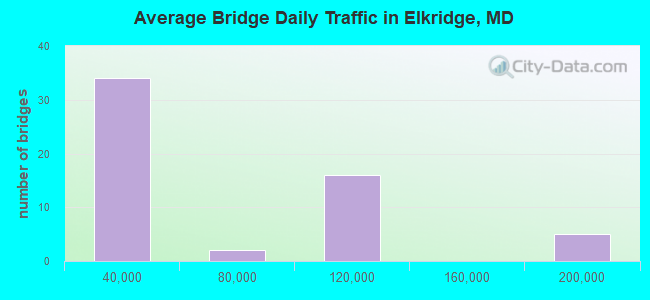
- 2,739,215Total average daily traffic
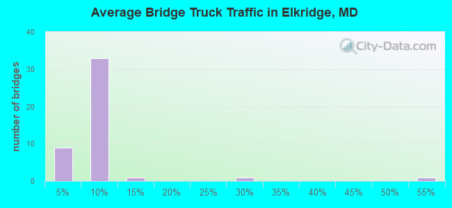
- 148,084Total average daily truck traffic
- National Bridge Inventory (NBI) Registered Bridges for Elkridge
- No street view available for this location
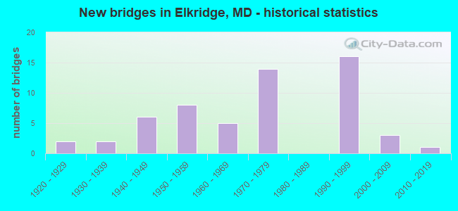
- New bridges - historical statistics
- 21920-1929
- 21930-1939
- 61940-1949
- 81950-1959
- 51960-1969
- 141970-1979
- 161990-1999
- 32000-2009
- 12010-2019
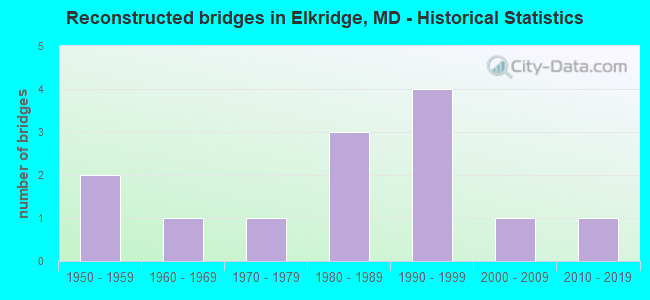
- Reconstructed bridges - Historical Statistics
- 21950-1959
- 11960-1969
- 11970-1979
- 31980-1989
- 41990-1999
- 12000-2009
- 12010-2019
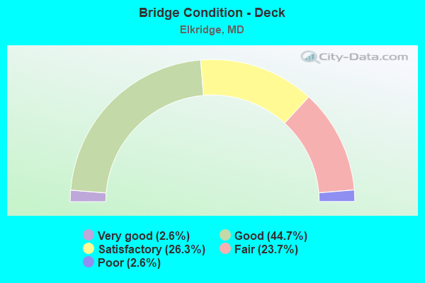
- Bridge Condition - Deck
- 2.6%Very good
- 44.7%Good
- 26.3%Satisfactory
- 23.7%Fair
- 2.6%Poor
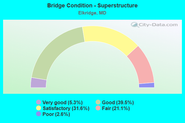
- Bridge Condition - Superstructure
- 5.3%Very good
- 39.5%Good
- 31.6%Satisfactory
- 21.1%Fair
- 2.6%Poor
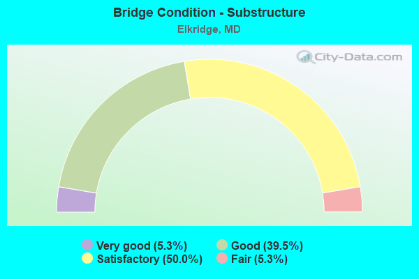
- Bridge Condition - Substructure
- 5.3%Very good
- 39.5%Good
- 50.0%Satisfactory
- 5.3%Fair
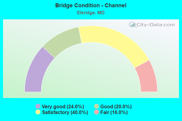
- Bridge Condition - Channel
- 24.0%Very good
- 20.0%Good
- 40.0%Satisfactory
- 16.0%Fair
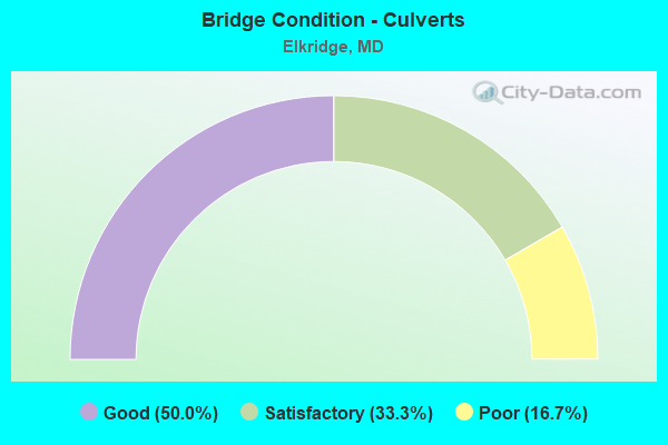
- Bridge Condition - Culverts
- 50.0%Good
- 33.3%Satisfactory
- 16.7%Poor
Find on map >> Show street view
Structure Number: 300000HOY01401, Location: Milepost M1.4 (Lat: 39.218222, Lng: -76.707361), Route carried "on" structure: Interstate 895, Year Built: 1973, Status: Open, Structure Length: 20.57m (67.49ft), Average Daily Traffic: 15,114 (year 2019), Truck Traffic: 3%, Average Future Daily Traffic: 19,227 (year 2041), Design Load: HS 20, Features Intersected: US 1&PATAPSCO RIVER&RAMP
Minimum Vertical Clearance: 30+ m (98+ ft), Kilometerpoint: 2.253, Lanes on structure: 4, Lanes under structure: 4, Base Highway Network: Yes, Toll: On toll road, Owner: State Toll Authority, Approaching Roadway Width: 11.9m (39.0ft), Skew: 35 degrees, Material/Design: Steel, Design/Construction: Stringer/Multi-beam, Number Of Spans In Main Unit: 4, Length of Maximum Span: 76.2m (250.0ft), Curb-To-Curb Width: 19.7m (64.6ft), Out-to-Out Width: 21.5m (70.5ft)
Condition: Deck: Fair, Superstructure: Satisfactory, Substructure: Good, Channel: Satisfactory, Operating Rating: 45.8 metric tons, Method Used To Determine Operating Rating: Load Factor (LF), Inventory Rating: 27.2 metric tons, Method Used To Determine Inventory Rating: Load Factor (LF), Structural Evaluation: Equal to present minimum criteria, Deck Geometry: Equal to present minimum criteria, Underclear: High priority of corrective action, Waterway Adequacy: Equal to present desirable criteria, Approach Roadway Alignment: Equal to present desirable criteria, Designated Inspection Frequency: Every 24 months, Underwater Inspection Frequency: Every 48 months, Inspection Date: October 2021, Underwater Inspection Date: October 2019, Deck Structure Type: Concrete Cast-file-Place, Wearing Surface/Protective System: Wearing Surface: Monolithic Concrete
Find on map >> Show street view
Structure Number: 10000002001901, Location: 2.44 MI N OF MD 100 (Lat: 39.197606, Lng: -76.702600), Route carried "under" structure: State highway 295, Year Built: 1950, Structure Length: 0. m, Average Daily Traffic: 88,882 (year 2009), Features Intersected: MD 295 NBR, Facility Carried by Structure: RIDGE ROAD
Minimum Vertical Clearance: 4.88m (16.01ft), Kilometerpoint: 18.327, Lanes on structure: 2, Lanes under structure: 3, Material/Design: Steel, Design/Construction: Stringer/Multi-beam, Length of Maximum Span: 18.3m (60.0ft)
Find on map >> Show street view
Structure Number: 10000002017901, Location: 0.18 M E OF HOWARD CO LN (Lat: 39.178303, Lng: -76.738317), Route carried "under" structure: State highway 100M, Year Built: 1996, Structure Length: 0. m, Average Daily Traffic: 83,402 (year 2009), Truck Traffic: 8%, Features Intersected: MD 100
Minimum Vertical Clearance: 4.88m (16.01ft), Kilometerpoint: 0.290, Lanes on structure: 4, Lanes under structure: 4, Material/Design: Steel continuous, Design/Construction: Stringer/Multi-beam, Length of Maximum Span: 32.9m (107.9ft)
Find on map >> Show street view
Structure Number: 10000002021801, Location: 0.46 MI S OF IS 195 (Lat: 39.197997, Lng: -76.702653), Route carried "under" structure: State highway 295, Year Built: 1950, Structure Length: 0. m, Average Daily Traffic: 88,882 (year 2009), Features Intersected: MD 295 SBR, Facility Carried by Structure: RIDGE ROAD
Minimum Vertical Clearance: 4.88m (16.01ft), Kilometerpoint: 18.327, Lanes on structure: 2, Lanes under structure: 3, Material/Design: Steel, Design/Construction: Stringer/Multi-beam, Length of Maximum Span: 18.3m (60.0ft)
Find on map >> Show street view
Structure Number: 10000002021901, Location: 0.41 MI N OF IS 695 (Lat: 39.197606, Lng: -76.702600), Route carried "under" structure: State highway 295, Year Built: 1949, Structure Length: 0. m, Average Daily Traffic: 80,822 (year 2009), Features Intersected: MD 295 SBR, Facility Carried by Structure: MD 168
Minimum Vertical Clearance: 4.88m (16.01ft), Kilometerpoint: 23.556, Lanes on structure: 2, Lanes under structure: 3, Material/Design: Steel, Design/Construction: Stringer/Multi-beam, Length of Maximum Span: 17.4m (57.1ft)
Find on map >> Show street view
Structure Number: 100000030243011, Location: ON HOWARD CO LINE (Lat: 39.224350, Lng: -76.718278), Route carried "under" structure: ServiceState lands road , Year Built: 1968, Structure Length: 0. m, Average Daily Traffic: 99 (year 2006), Features Intersected: CSX TRANS,PAT RIV,CO RD, Facility Carried by Structure: IS 95 NBR
Minimum Vertical Clearance: 16.76m (54.99ft), Kilometerpoint: 1.175, Lanes on structure: 4, Lanes under structure: 2, Material/Design: Steel continuous, Design/Construction: Stringer/Multi-beam, Length of Maximum Span: 53.0m (173.9ft)
Find on map >> Show street view
Structure Number: 100000130049013, Location: 0.5 MILE NORTH OF MD 103 (Lat: 39.197333, Lng: -76.767092), Route carried "under" structure: Interstate 95, Year Built: 1970, Structure Length: 0. m, Average Daily Traffic: 192,100 (year 2009), Features Intersected: IS 95, Facility Carried by Structure: MD 100 EBR
Minimum Vertical Clearance: 4.88m (16.01ft), Kilometerpoint: 13.306, Lanes on structure: 3, Lanes under structure: 10, Material/Design: Steel continuous, Design/Construction: Stringer/Multi-beam, Length of Maximum Span: 47.2m (154.9ft)
Find on map >> Show street view
Structure Number: 100000130049014, Location: 0.5 MILE NORTH OF MD 103 (Lat: 39.196919, Lng: -76.766089), Route carried "under" structure: Interstate 95, Year Built: 1970, Structure Length: 0. m, Average Daily Traffic: 192,100 (year 2009), Features Intersected: IS 95, Facility Carried by Structure: MD 100 WBR
Minimum Vertical Clearance: 4.88m (16.01ft), Kilometerpoint: 13.306, Lanes on structure: 3, Lanes under structure: 10, Material/Design: Steel continuous, Design/Construction: Stringer/Multi-beam, Length of Maximum Span: 46.9m (153.9ft)
Find on map >> Show street view
Structure Number: 100000130050011, Location: 0.71 MILE NORTH OF US I (Lat: 39.191242, Lng: -76.772650), Route carried "under" structure: State highway 103, Year Built: 1968, Structure Length: 0. m, Average Daily Traffic: 8,201 (year 2009), Truck Traffic: 8%, Features Intersected: MD 103, Facility Carried by Structure: IS 95 NB
Minimum Vertical Clearance: 4.88m (16.01ft), Kilometerpoint: 3.025, Lanes on structure: 4, Lanes under structure: 2, Material/Design: Concrete continuous, Design/Construction: Slab, Length of Maximum Span: 19.2m (63.0ft)
Find on map >> Show street view
Structure Number: 100000130050012, Location: 0.71 MILE NORTH OF US I (Lat: 39.191728, Lng: -76.772711), Route carried "under" structure: State highway 103, Year Built: 1968, Structure Length: 0. m, Average Daily Traffic: 8,201 (year 2009), Truck Traffic: 8%, Features Intersected: MD 103, Facility Carried by Structure: IS 95 SB
Minimum Vertical Clearance: 4.88m (16.01ft), Kilometerpoint: 3.025, Lanes on structure: 4, Lanes under structure: 2, Material/Design: Concrete continuous, Design/Construction: Slab, Length of Maximum Span: 19.2m (63.0ft)
Find on map >> Show street view
Structure Number: 10000013005701, Location: 0.16 MILE NORTH OF MD 100 (Lat: 39.198306, Lng: -76.764261), Route carried "under" structure: Interstate 95, Year Built: 1970, Structure Length: 0. m, Average Daily Traffic: 192,100 (year 2009), Features Intersected: IS 95, Facility Carried by Structure: MD 100 RAMP 'A'
Minimum Vertical Clearance: 4.88m (16.01ft), Kilometerpoint: 13.564, Lanes on structure: 1, Lanes under structure: 8, Material/Design: Steel continuous, Design/Construction: Stringer/Multi-beam, Length of Maximum Span: 41.1m (134.8ft)
Find on map >> Show street view
Structure Number: 100000130058013, Location: 0.92 MILE WEST OF US 1 (Lat: 39.198586, Lng: -76.768556), Route carried "under" structure: Ramp State highway 100, Year Built: 1970, Structure Length: 0. m, Average Daily Traffic: 15,864 (year 2006), Features Intersected: MD 100 RAMP 'A'
Minimum Vertical Clearance: 5.18m (16.99ft), Kilometerpoint: 8.930, Lanes on structure: 2, Lanes under structure: 1, Material/Design: Concrete continuous, Design/Construction: Slab, Length of Maximum Span: 16.5m (54.1ft)
Find on map >> Show street view
Structure Number: 100000130058014, Location: 0.92 MILE WEST OF US 1 (Lat: 39.198492, Lng: -76.767928), Route carried "under" structure: Ramp State highway 100, Year Built: 1970, Structure Length: 0. m, Average Daily Traffic: 15,864 (year 2006), Features Intersected: MD 100 RAMP 'A'
Minimum Vertical Clearance: 5.18m (16.99ft), Kilometerpoint: 8.930, Lanes on structure: 2, Lanes under structure: 1, Material/Design: Concrete continuous, Design/Construction: Slab, Length of Maximum Span: 16.5m (54.1ft)
Find on map >> Show street view
Structure Number: 10000013011801, Location: 0.79 MILE EAST OF IS 95 (Lat: 39.188567, Lng: -76.756806), Route carried "under" structure: State highway 100, Year Built: 1994, Structure Length: 0. m, Average Daily Traffic: 83,402 (year 2009), Truck Traffic: 8%, Features Intersected: MD 100, Facility Carried by Structure: US 1
Minimum Vertical Clearance: 5.18m (16.99ft), Kilometerpoint: 10.410, Lanes on structure: 7, Lanes under structure: 3, Material/Design: Steel continuous, Design/Construction: Stringer/Multi-beam, Length of Maximum Span: 28.3m (92.8ft)