Bridge Statistics for Ellensburg, Washington (WA)
Condition, Traffic, Stress, Structural Evaluation, Project Costs
- National Bridge Inventory (NBI) Statistics
- 83Number of bridges
- 850ft / 259mTotal length
- $113,610,000Total costs
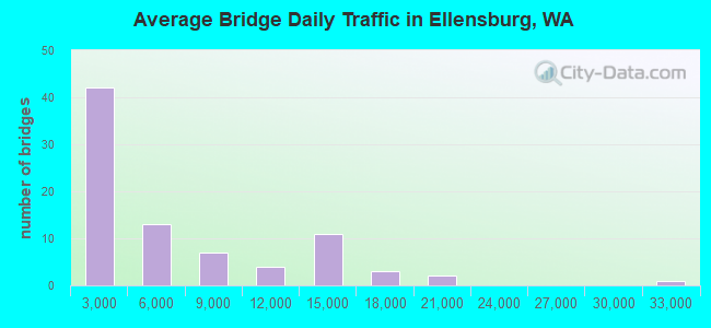
- 489,077Total average daily traffic
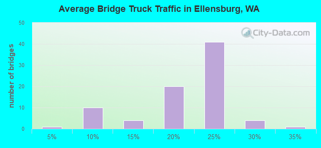
- 91,770Total average daily truck traffic
- National Bridge Inventory (NBI) Registered Bridges for Ellensburg
- No street view available for this location
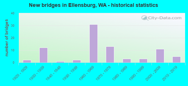
- New bridges - historical statistics
- 21920-1929
- 121930-1939
- 11940-1949
- 21950-1959
- 311960-1969
- 131970-1979
- 31980-1989
- 31990-1999
- 112000-2009
- 52010-2019
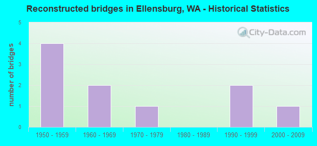
- Reconstructed bridges - Historical Statistics
- 41950-1959
- 21960-1969
- 11970-1979
- 01980-1989
- 21990-1999
- 12000-2009
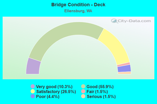
- Bridge Condition - Deck
- 10.3%Very good
- 55.9%Good
- 26.5%Satisfactory
- 1.5%Fair
- 4.4%Poor
- 1.5%Serious
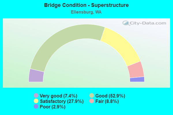
- Bridge Condition - Superstructure
- 7.4%Very good
- 52.9%Good
- 27.9%Satisfactory
- 8.8%Fair
- 2.9%Poor
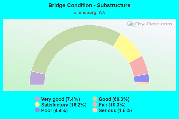
- Bridge Condition - Substructure
- 7.4%Very good
- 60.3%Good
- 16.2%Satisfactory
- 10.3%Fair
- 4.4%Poor
- 1.5%Serious
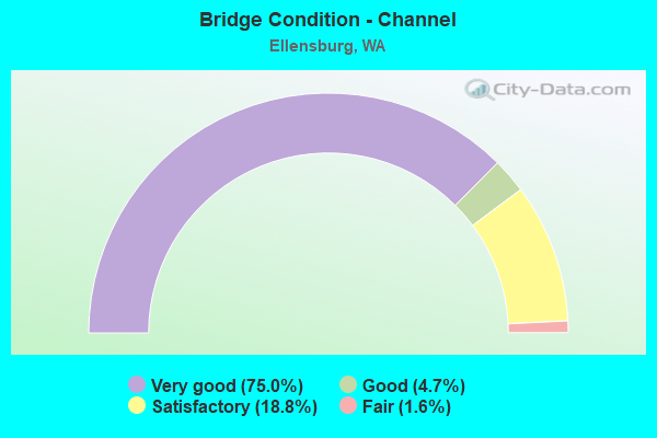
- Bridge Condition - Channel
- 75.0%Very good
- 4.7%Good
- 18.8%Satisfactory
- 1.6%Fair
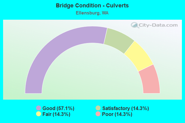
- Bridge Condition - Culverts
- 57.1%Good
- 14.3%Satisfactory
- 14.3%Fair
- 14.3%Poor
Find on map >> Show street view
Structure Number: 88753, Location: 0.47 WEST NORTH FERGUSON (Lat: 46.985308, Lng: -120.477044), Route carried "on" structure: County highway 96951, Year Built: 2015, Status: Open, Structure Length: 0.82m (2.69ft), Average Daily Traffic: 1,876 (year 2019), Truck Traffic: 19%, Average Future Daily Traffic: 4,971 (year 2039), Design Load: HL 93, Features Intersected: NANEUM CREEK, Facility Carried by Structure: kITTITAS HWY
Minimum Vertical Clearance: 30+ m (98+ ft), Kilometerpoint: 0.001, Lanes on structure: 2, Owner: County Highway Agency, Approaching Roadway Width: 9.4m (30.8ft), Material/Design: Concrete, Design/Construction: Frame, Number Of Spans In Main Unit: 1, Length of Maximum Span: 7.9m (25.9ft), Curb-To-Curb Width: 9.9m (32.5ft), Out-to-Out Width: 12.3m (40.4ft)
Condition: Deck: Very good, Superstructure: Very good, Substructure: Very good, Channel: Very good, Operating Rating: 45.7 metric tons, Method Used To Determine Operating Rating: Load and Resistance Factor Rating (LRFR) rating reported by rating factor(RF) method using HL-93 loadings, Inventory Rating: 35.0 metric tons, Method Used To Determine Inventory Rating: Load and Resistance Factor Rating (LRFR) rating reported by rating factor(RF) method using HL-93 loadings, Structural Evaluation: Equal to present desirable criteria, Deck Geometry: Somewhat better than minimum adequacy, Waterway Adequacy: Equal to present desirable criteria, Approach Roadway Alignment: Equal to present desirable criteria, Designated Inspection Frequency: Every 24 months, Inspection Date: November 2021, Deck Structure Type: Concrete Precast Panels, Wearing Surface/Protective System: Wearing Surface: Bituminous, Membrane: Preformed Fabric
Find on map >> Show street view
Structure Number: 89051, Location: 0.05 North of Willis Road (Lat: 46.990614, Lng: -120.497908), Route carried "on" structure: County highway 96200, Year Built: 2019, Status: Open, Structure Length: 0.98m (3.22ft), Average Daily Traffic: 2,357 (year 2019), Truck Traffic: 22%, Average Future Daily Traffic: 6,246 (year 2039), Design Load: HL 93, Features Intersected: Town Canal, Facility Carried by Structure: Number 6 Road
Minimum Vertical Clearance: 30+ m (98+ ft), Kilometerpoint: 0.001, Lanes on structure: 2, Owner: County Highway Agency, Approaching Roadway Width: 6.1m (20.0ft), Skew: 2 degrees, Material/Design: Prestressed concrete, Design/Construction: Stringer/Multi-beam, Number Of Spans In Main Unit: 1, Length of Maximum Span: 9.8m (32.2ft), Curb-To-Curb Width: 9.8m (32.2ft), Out-to-Out Width: 11.0m (36.1ft)
Condition: Deck: Very good, Superstructure: Very good, Substructure: Very good, Channel: Very good, Operating Rating: 60.9 metric tons, Method Used To Determine Operating Rating: Load and Resistance Factor Rating (LRFR) rating reported by rating factor(RF) method using HL-93 loadings, Inventory Rating: 37.9 metric tons, Method Used To Determine Inventory Rating: Load and Resistance Factor Rating (LRFR) rating reported by rating factor(RF) method using HL-93 loadings, Structural Evaluation: Equal to present desirable criteria, Deck Geometry: Meets minimum limits, Waterway Adequacy: Equal to present desirable criteria, Approach Roadway Alignment: Equal to present desirable criteria, Designated Inspection Frequency: Every 24 months, Inspection Date: March 2021, Deck Structure Type: Concrete Cast-file-Place, Wearing Surface/Protective System: Wearing Surface: Monolithic Concrete, Deck Protection: Epoxy Coated Reinforcing
Find on map >> Show street view
Structure Number: 7830B, Location: 20.2 E JCT SR 970 (Lat: 47.005694, Lng: -120.591528), Route carried "under" structure: Interstate 90, Year Built: 1966, Structure Length: 0. m, Average Daily Traffic: 30,901 (year 2019), Truck Traffic: 20%, Features Intersected: I-90, WEST ELLENSBURG, Facility Carried by Structure: US 97
Minimum Vertical Clearance: 5.08m (16.67ft), Kilometerpoint: 170.687, Lanes on structure: 2, Lanes under structure: 4, Material/Design: Prestressed concrete, Design/Construction: Stringer/Multi-beam, Length of Maximum Span: 27.4m (89.9ft)
Find on map >> Show street view
Structure Number: 8385A, Location: 4.8 E JCT US 97 (Lat: 46.970778, Lng: -120.510889), Route carried "under" structure: Interstate 90, Year Built: 1968, Structure Length: 0. m, Average Daily Traffic: 14,538 (year 2019), Truck Traffic: 20%, Features Intersected: I-90, Facility Carried by Structure: I-82
Minimum Vertical Clearance: 5.21m (17.09ft), Kilometerpoint: 178.428, Lanes on structure: 2, Lanes under structure: 4, Material/Design: Concrete continuous, Design/Construction: Box Beam or Girders - Multiple, Length of Maximum Span: 31.1m (102.0ft)
Find on map >> Show street view
Structure Number: 8385B, Location: 4.8 E JCT US 97 (Lat: 46.970750, Lng: -120.511028), Route carried "under" structure: Interstate 90, Year Built: 1968, Structure Length: 0. m, Average Daily Traffic: 14,538 (year 2019), Truck Traffic: 20%, Features Intersected: E-E RAMP, I-90, Facility Carried by Structure: I-82
Minimum Vertical Clearance: 5.18m (16.99ft), Kilometerpoint: 178.412, Lanes on structure: 1, Lanes under structure: 4, Material/Design: Concrete continuous, Design/Construction: Box Beam or Girders - Multiple, Length of Maximum Span: 31.1m (102.0ft)
Find on map >> Show street view
Structure Number: 8385C, Location: 0.1 E JCT I-90 (Lat: 46.968556, Lng: -120.510111), Route carried "under" structure: Interstate 82, Year Built: 1968, Structure Length: 0. m, Average Daily Traffic: 7,946 (year 2019), Truck Traffic: 28%, Features Intersected: E-E RAMP
Minimum Vertical Clearance: 5.21m (17.09ft), Kilometerpoint: 1.304, Lanes on structure: 1, Lanes under structure: 2, Material/Design: Concrete continuous, Design/Construction: Box Beam or Girders - Multiple, Length of Maximum Span: 39.6m (129.9ft)
Find on map >> Show street view
Structure Number: 8385D, Location: 0.6 E JCT I-82 (Lat: 46.970306, Lng: -120.498111), Route carried "under" structure: Interstate 90, Year Built: 1968, Structure Length: 0. m, Average Daily Traffic: 14,538 (year 2019), Truck Traffic: 20%, Features Intersected: I-90, Facility Carried by Structure: COUNTY RD NO 6
Minimum Vertical Clearance: 5.26m (17.26ft), Kilometerpoint: 179.377, Lanes on structure: 2, Lanes under structure: 4, Material/Design: Prestressed concrete continuous, Design/Construction: Stringer/Multi-beam, Length of Maximum Span: 34.4m (112.9ft)
Find on map >> Show street view
Structure Number: 8672A, Location: 0.9 E JCT I-90 (Lat: 46.958694, Lng: -120.507333), Route carried "under" structure: Interstate 82, Year Built: 1970, Structure Length: 0. m, Average Daily Traffic: 18,807 (year 2019), Truck Traffic: 21%, Features Intersected: I-82, Facility Carried by Structure: TJOSSEM RD
Minimum Vertical Clearance: 5.38m (17.65ft), Kilometerpoint: 1.416, Lanes on structure: 2, Lanes under structure: 4, Material/Design: Prestressed concrete continuous, Design/Construction: Stringer/Multi-beam, Length of Maximum Span: 36.0m (118.1ft)
Find on map >> Show street view
Structure Number: 8672B, Location: 20.9 N YAKIMA CO (Lat: 46.926417, Lng: -120.498694), Route carried "under" structure: State highway 821, Year Built: 1970, Structure Length: 0. m, Average Daily Traffic: 1,148 (year 2019), Truck Traffic: 17%, Features Intersected: SR 821, WHIPPLE WASTEWAY, Facility Carried by Structure: I-82
Minimum Vertical Clearance: 4.57m (14.99ft), Kilometerpoint: 40.523, Lanes on structure: 3, Lanes under structure: 2, Material/Design: Prestressed concrete continuous, Design/Construction: Stringer/Multi-beam, Length of Maximum Span: 41.1m (134.8ft)
Find on map >> Show street view
Structure Number: 8672C, Location: 20.9 N YAKIMA CO (Lat: 46.926417, Lng: -120.498139), Route carried "under" structure: State highway 821, Year Built: 1970, Structure Length: 0. m, Average Daily Traffic: 1,148 (year 2019), Truck Traffic: 17%, Features Intersected: SR 821, WHIPPLE WASTEWAY, Facility Carried by Structure: I-82
Minimum Vertical Clearance: 4.52m (14.83ft), Kilometerpoint: 40.572, Lanes on structure: 2, Lanes under structure: 2, Material/Design: Prestressed concrete continuous, Design/Construction: Stringer/Multi-beam, Length of Maximum Span: 41.1m (134.8ft)