Bridge Statistics for Erwin, New York (NY)
Condition, Traffic, Stress, Structural Evaluation, Project Costs
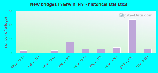
- New bridges - historical statistics
- 21930-1939
- 21950-1959
- 81960-1969
- 31970-1979
- 31980-1989
- 41990-1999
- 242000-2009
- 32010-2019
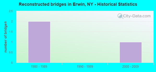
- Reconstructed bridges - Historical Statistics
- 21980-1989
- 01990-1999
- 12000-2009
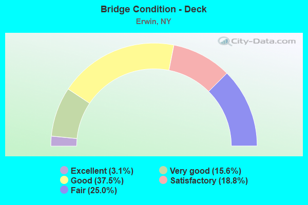
- Bridge Condition - Deck
- 3.1%Excellent
- 15.6%Very good
- 37.5%Good
- 18.8%Satisfactory
- 25.0%Fair
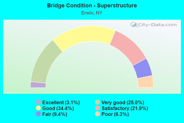
- Bridge Condition - Superstructure
- 3.1%Excellent
- 25.0%Very good
- 34.4%Good
- 21.9%Satisfactory
- 9.4%Fair
- 6.3%Poor
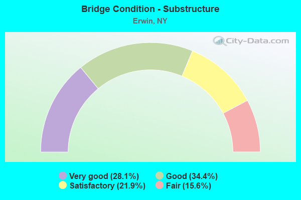
- Bridge Condition - Substructure
- 28.1%Very good
- 34.4%Good
- 21.9%Satisfactory
- 15.6%Fair
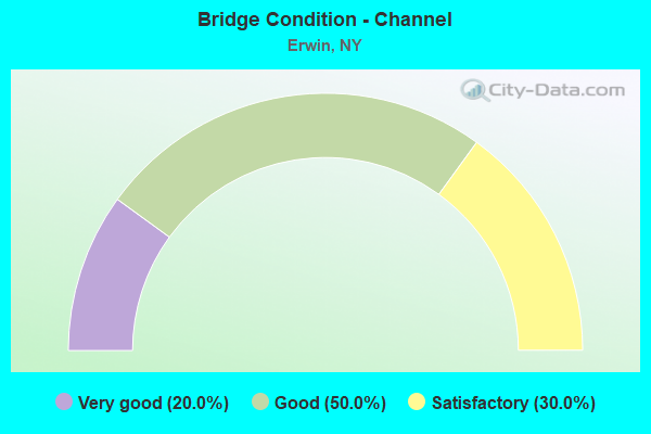
- Bridge Condition - Channel
- 20.0%Very good
- 50.0%Good
- 30.0%Satisfactory
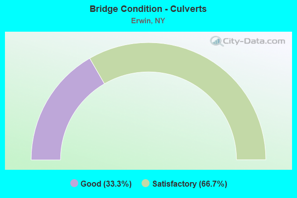
- Bridge Condition - Culverts
- 33.3%Good
- 66.7%Satisfactory
Find on map >> Show street view
Structure Number: 1064251, Location: 0.3 MI NE GANGMILLS (Lat: 42.150872, Lng: -77.102700), Route carried "under" structure: Other road , Year Built: 2006, Structure Length: 0. m, Average Daily Traffic: 600 (year 2021), Features Intersected: R Dann EB Ramp, Facility Carried by Structure: RTE 15U
Minimum Vertical Clearance: 5.77m (18.93ft), Kilometerpoint: 0.338, Lanes on structure: 3, Lanes under structure: 2, Material/Design: Steel, Design/Construction: Stringer/Multi-beam, Length of Maximum Span: 50.0m (164.0ft)
Find on map >> Show street view
Structure Number: 1064252, Location: .3 MILE NE OF GANG MILLS (Lat: 42.150814, Lng: -77.102442), Route carried "under" structure: Other road , Year Built: 2005, Structure Length: 0. m, Average Daily Traffic: 600 (year 2021), Features Intersected: R Dann EB Ramp, Facility Carried by Structure: RTE 15U
Minimum Vertical Clearance: 5.71m (18.73ft), Kilometerpoint: 0.000, Lanes on structure: 3, Lanes under structure: 2, Material/Design: Steel, Design/Construction: Stringer/Multi-beam, Length of Maximum Span: 63.4m (208.0ft)
Find on map >> Show street view
Structure Number: 1074, Location: INTERSECT. HAMILTON & I86 (Lat: 42.156292, Lng: -77.095667), Route carried "under" structure: Interstate 86, Year Built: 1989, Structure Length: 0. m, Average Daily Traffic: 25,674 (year 1998), Features Intersected: 86I 17 64041413 WB, RTE, Facility Carried by Structure: RTE 15
Minimum Vertical Clearance: 5.11m (16.77ft), Kilometerpoint: 66.452, Lanes on structure: 3, Lanes under structure: 3, Material/Design: Prestressed concrete continuous, Design/Construction: Box Beam or Girders - Multiple, Length of Maximum Span: 23.1m (75.8ft)
Find on map >> Show street view
Structure Number: 107831, Location: Exit 44 Jct I99 & I86 (Lat: 42.154519, Lng: -77.097006), Route carried "under" structure: Interstate , Year Built: 2005, Structure Length: 0. m, Features Intersected: 86I 17 64041440 WB, 86I, Facility Carried by Structure: RTE 15
Minimum Vertical Clearance: 6.17m (20.24ft), Kilometerpoint: 20.113, Lanes on structure: 2, Lanes under structure: 2, Material/Design: Steel, Design/Construction: Stringer/Multi-beam, Length of Maximum Span: 77.1m (253.0ft)
Find on map >> Show street view
Structure Number: 107832, Location: JCT SR 15 & I86 (Lat: 42.154317, Lng: -77.095978), Route carried "under" structure: Other road , Year Built: 2005, Structure Length: 0. m, Average Daily Traffic: 10 (year 2021), Features Intersected: FUTURE TOWN ROAD, COHOCT, Facility Carried by Structure: Ramp 99INB to 86IE
Minimum Vertical Clearance: 4.90m (16.08ft), Kilometerpoint: 0.000, Lanes on structure: 2, Lanes under structure: 2, Material/Design: Steel continuous, Design/Construction: Stringer/Multi-beam, Length of Maximum Span: 76.1m (249.7ft)
Find on map >> Show street view
Structure Number: 107834, Location: Steuben County (Lat: 42.154667, Lng: -77.097556), Route carried "under" structure: Ramp City street , Year Built: 2006, Structure Length: 0. m, Features Intersected: South Hamilton Street, C, Facility Carried by Structure: RTE 15
Minimum Vertical Clearance: 5.26m (17.26ft), Kilometerpoint: 0.000, Lanes on structure: 2, Lanes under structure: 1, Material/Design: Steel continuous, Design/Construction: Stringer/Multi-beam, Length of Maximum Span: 83.5m (274.0ft)
Find on map >> Show street view
Structure Number: 107835, Location: JCT US15-I86 (Lat: 42.155761, Lng: -77.094506), Route carried "under" structure: Interstate , Year Built: 2006, Structure Length: 0. m, Average Daily Traffic: 49,245 (year 2008), Features Intersected: 86I 17 64112D01, 86I 17, Facility Carried by Structure: 86I WB to 99I SB
Minimum Vertical Clearance: 5.51m (18.08ft), Kilometerpoint: 70.957, Lanes on structure: 2, Lanes under structure: 2, Material/Design: Steel continuous, Design/Construction: Stringer/Multi-beam, Length of Maximum Span: 50.6m (166.0ft)
Find on map >> Show street view
Structure Number: 107838, Location: 1 mi NE Mills Gang (Lat: 42.151811, Lng: -77.105531), Route carried "under" structure: City street , Year Built: 2008, Structure Length: 0. m, Features Intersected: S.Hamilton St, Facility Carried by Structure: Robert Dann WB
Minimum Vertical Clearance: 4.88m (16.01ft), Kilometerpoint: 0.000, Lanes on structure: 1, Lanes under structure: 4, Material/Design: Steel, Design/Construction: Stringer/Multi-beam, Length of Maximum Span: 44.1m (144.7ft)
Find on map >> Show street view
Structure Number: 107839, Location: 1 mi NE Mills Gang (Lat: 42.151711, Lng: -77.105689), Route carried "under" structure: City street , Year Built: 2008, Structure Length: 0. m, Average Daily Traffic: 9,449 (year 2015), Features Intersected: S.Hamilton St, Facility Carried by Structure: Robert Dann EB
Minimum Vertical Clearance: 4.65m (15.26ft), Kilometerpoint: 0.000, Lanes on structure: 2, Lanes under structure: 4, Material/Design: Steel, Design/Construction: Stringer/Multi-beam, Length of Maximum Span: 42.0m (137.8ft)