Bridge Statistics for Eugene, Oregon (OR)
Condition, Traffic, Stress, Structural Evaluation, Project Costs
- National Bridge Inventory (NBI) Statistics
- 226Number of bridges
- 3,402ft / 1,037mTotal length
- $104,434,000Total costs
- 4,116,230Total average daily traffic
- 437,320Total average daily truck traffic
- National Bridge Inventory (NBI) Registered Bridges for Eugene
- No street view available for this location
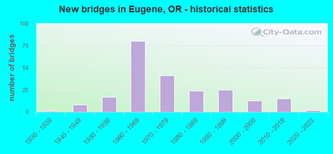
- New bridges - historical statistics
- 11930-1939
- 81940-1949
- 171950-1959
- 801960-1969
- 411970-1979
- 241980-1989
- 251990-1999
- 132000-2009
- 152010-2019
- 22020-2022
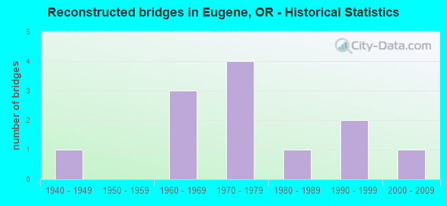
- Reconstructed bridges - Historical Statistics
- 11940-1949
- 01950-1959
- 31960-1969
- 41970-1979
- 11980-1989
- 21990-1999
- 12000-2009
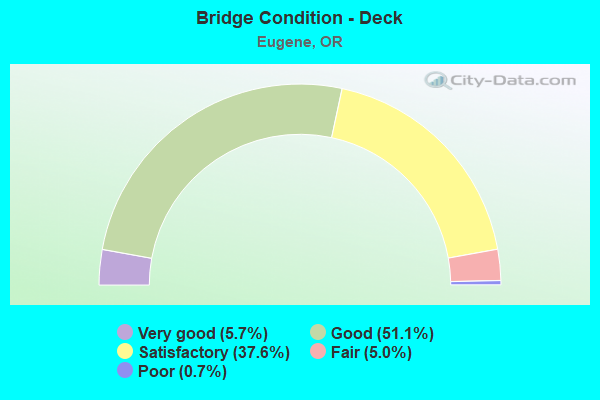
- Bridge Condition - Deck
- 5.7%Very good
- 51.1%Good
- 37.6%Satisfactory
- 5.0%Fair
- 0.7%Poor
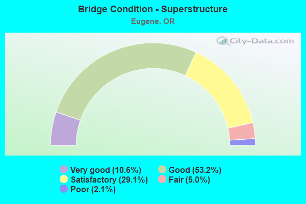
- Bridge Condition - Superstructure
- 10.6%Very good
- 53.2%Good
- 29.1%Satisfactory
- 5.0%Fair
- 2.1%Poor
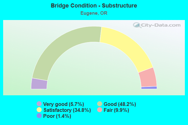
- Bridge Condition - Substructure
- 5.7%Very good
- 48.2%Good
- 34.8%Satisfactory
- 9.9%Fair
- 1.4%Poor
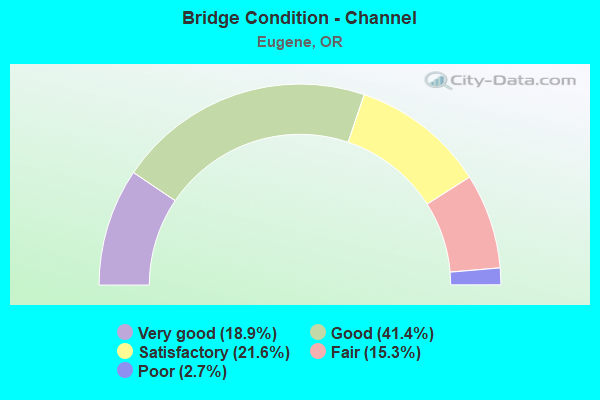
- Bridge Condition - Channel
- 18.9%Very good
- 41.4%Good
- 21.6%Satisfactory
- 15.3%Fair
- 2.7%Poor
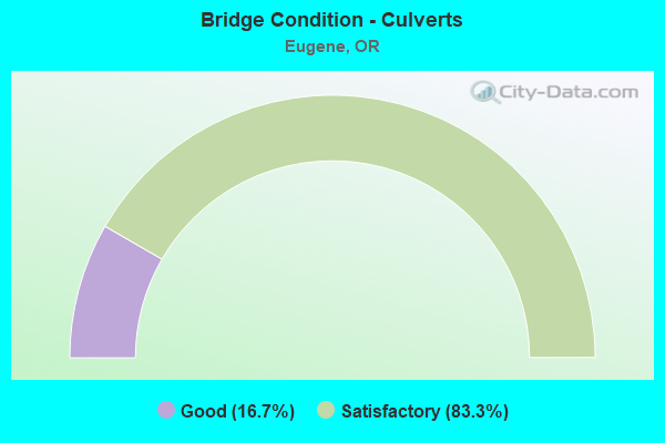
- Bridge Condition - Culverts
- 16.7%Good
- 83.3%Satisfactory
Find on map >> Show street view
Structure Number: 8705A069 01015, Location: 02.6 W JCT HWY 001 (Lat: 44.090914, Lng: -123.097747), Route carried "on" structure: State highway 569, Year Built: 1965, Status: Open, Structure Length: 2.57m (8.43ft), Average Daily Traffic: 26,536 (year 2020), Truck Traffic: 10%, Average Future Daily Traffic: 33,900 (year 2040), Design Load: HS 20, Features Intersected: DEBRICK SLOUGH, Facility Carried by Structure: HWY 69 (EB)
Minimum Vertical Clearance: 30+ m (98+ ft), Kilometerpoint: 16.335, Lanes on structure: 2, Base Highway Network: Yes, Owner: State Highway Agency, Approaching Roadway Width: 12.5m (41.0ft), Material/Design: Prestressed concrete, Design/Construction: Slab, Number Of Spans In Main Unit: 3, Length of Maximum Span: 8.2m (26.9ft), Curb-To-Curb Width: 12.5m (41.0ft), Out-to-Out Width: 13.4m (44.0ft)
Condition: Deck: Good, Superstructure: Good, Substructure: Good, Channel: Very good, Operating Rating: 30.5 metric tons, Method Used To Determine Operating Rating: Load and Resistance Factor Rating (LRFR) rating reported by rating factor(RF) method using HL-93 loadings, Inventory Rating: 23.7 metric tons, Method Used To Determine Inventory Rating: Load and Resistance Factor Rating (LRFR) rating reported by rating factor(RF) method using HL-93 loadings, Structural Evaluation: Somewhat better than minimum adequacy, Deck Geometry: Better than present minimum criteria, Waterway Adequacy: Equal to present desirable criteria, Approach Roadway Alignment: Equal to present desirable criteria, Designated Inspection Frequency: Every 24 months, Inspection Date: April 2021, Deck Structure Type: Concrete Precast Panels, Wearing Surface/Protective System: Wearing Surface: Bituminous, Membrane: Preformed Fabric
Find on map >> Show street view
Structure Number: 8705B069C01015, Location: 02.6 W JCT HWY 001 (Lat: 44.091536, Lng: -123.097186), Route carried "on" structure: Ramp State highway 69, Year Built: 1964, Status: Open, Structure Length: 1.83m (6.00ft), Average Daily Traffic: 8,733 (year 2020), Truck Traffic: 10%, Average Future Daily Traffic: 9,500 (year 2030), Design Load: HS 20, Features Intersected: SLOUGH (WB OFF RAMP)
Minimum Vertical Clearance: 30+ m (98+ ft), Kilometerpoint: 16.335, Lanes on structure: 1, Base Highway Network: Yes, Owner: State Highway Agency, Approaching Roadway Width: 6.7m (22.0ft), Material/Design: Prestressed concrete, Design/Construction: Slab, Number Of Spans In Main Unit: 3, Length of Maximum Span: 6.1m (20.0ft), Curb-To-Curb Width: 6.7m (22.0ft), Out-to-Out Width: 7.9m (25.9ft)
Condition: Deck: Good, Superstructure: Satisfactory, Substructure: Good, Channel: Very good, Operating Rating: 38.6 metric tons, Method Used To Determine Operating Rating: Load and Resistance Factor Rating (LRFR) rating reported by rating factor(RF) method using HL-93 loadings, Inventory Rating: 29.8 metric tons, Method Used To Determine Inventory Rating: Load and Resistance Factor Rating (LRFR) rating reported by rating factor(RF) method using HL-93 loadings, Structural Evaluation: Equal to present minimum criteria, Deck Geometry: Equal to present minimum criteria, Waterway Adequacy: Equal to present desirable criteria, Approach Roadway Alignment: Equal to present desirable criteria, Designated Inspection Frequency: Every 24 months, Inspection Date: April 2021, Deck Structure Type: Concrete Precast Panels, Wearing Surface/Protective System: Wearing Surface: Bituminous
Find on map >> Show street view
Structure Number: 8705C069C01015, Location: 02.6 W JCT HWY 001 (Lat: 44.090242, Lng: -123.097633), Route carried "on" structure: Ramp State highway 69, Year Built: 1964, Status: Open, Structure Length: 2.19m (7.19ft), Average Daily Traffic: 15,744 (year 2020), Truck Traffic: 10%, Average Future Daily Traffic: 14,400 (year 2030), Design Load: HS 20, Features Intersected: SLOUGH (EB ON RAMP)
Minimum Vertical Clearance: 30+ m (98+ ft), Kilometerpoint: 16.335, Lanes on structure: 1, Base Highway Network: Yes, Owner: State Highway Agency, Approaching Roadway Width: 6.4m (21.0ft), Material/Design: Prestressed concrete, Design/Construction: Slab, Number Of Spans In Main Unit: 3, Length of Maximum Span: 7.3m (24.0ft), Curb-To-Curb Width: 6.4m (21.0ft), Out-to-Out Width: 7.3m (24.0ft)
Condition: Deck: Good, Superstructure: Satisfactory, Substructure: Good, Channel: Very good, Operating Rating: 42.1 metric tons, Method Used To Determine Operating Rating: Load and Resistance Factor Rating (LRFR) rating reported by rating factor(RF) method using HL-93 loadings, Inventory Rating: 32.4 metric tons, Method Used To Determine Inventory Rating: Load and Resistance Factor Rating (LRFR) rating reported by rating factor(RF) method using HL-93 loadings, Structural Evaluation: Equal to present minimum criteria, Deck Geometry: Somewhat better than minimum adequacy, Waterway Adequacy: Equal to present desirable criteria, Approach Roadway Alignment: Equal to present desirable criteria, Designated Inspection Frequency: Every 24 months, Inspection Date: April 2021, Deck Structure Type: Concrete Precast Panels, Wearing Surface/Protective System: Wearing Surface: Bituminous
Find on map >> Show street view
Structure Number: 8864A069 00706, Location: 00.5 N JCT HWY 01W (Lat: 44.097900, Lng: -123.156614), Route carried "on" structure: State highway 569, Year Built: 1963, Year Reconstructed: 1971, Status: Open, Structure Length: 16.67m (54.69ft), Average Daily Traffic: 53,100 (year 2020), Truck Traffic: 7%, Average Future Daily Traffic: 73,100 (year 2040), Design Load: HS 20, Features Intersected: UPRR & NW EXPRESSWAY, Facility Carried by Structure: HWY 69
Minimum Vertical Clearance: 30+ m (98+ ft), Kilometerpoint: 11.362, Lanes on structure: 6, Lanes under structure: 3, Base Highway Network: Yes, Owner: State Highway Agency, Approaching Roadway Width: 28.9m (94.8ft), Skew: 32 degrees, Material/Design: Steel continuous, Design/Construction: Stringer/Multi-beam, Number Of Spans In Main Unit: 3, Number Of Approach Spans: 4, Length of Maximum Span: 41.1m (134.8ft), Curb-To-Curb Width: 28.9m (94.8ft), Out-to-Out Width: 31.2m (102.4ft)
Condition: Deck: Satisfactory, Superstructure: Satisfactory, Substructure: Satisfactory, Operating Rating: 21.1 metric tons, Method Used To Determine Operating Rating: Load and Resistance Factor Rating (LRFR) rating reported by rating factor(RF) method using HL-93 loadings, Inventory Rating: 16.2 metric tons, Method Used To Determine Inventory Rating: Load and Resistance Factor Rating (LRFR) rating reported by rating factor(RF) method using HL-93 loadings, Structural Evaluation: Meets minimum limits, Deck Geometry: Better than present minimum criteria, Underclear: Meets minimum limits, Approach Roadway Alignment: Equal to present desirable criteria, Designated Inspection Frequency: Every 24 months, Inspection Date: April 2021, Deck Structure Type: Concrete Cast-file-Place
Find on map >> Show street view
Structure Number: 8965E227 00171, Location: 01.7 MI E OR99W JCT (Lat: 44.061267, Lng: -123.084614), Route carried "on" structure: Interstate 105, Year Built: 1963, Status: Open, Structure Length: 5.03m (16.50ft), Average Daily Traffic: 51,396 (year 2020), Truck Traffic: 7%, Average Future Daily Traffic: 75,600 (year 2040), Design Load: HS 20+Mod, Features Intersected: COUNTY CLUB ROAD
Minimum Vertical Clearance: 30+ m (98+ ft), Kilometerpoint: 2.752, Lanes on structure: 4, Lanes under structure: 4, Base Highway Network: Yes, Owner: State Highway Agency, Approaching Roadway Width: 23.3m (76.4ft), Skew: 31 degrees, Material/Design: Prestressed concrete, Design/Construction: Stringer/Multi-beam, Number Of Spans In Main Unit: 3, Length of Maximum Span: 16.8m (55.1ft), Curb-To-Curb Width: 23.3m (76.4ft), Out-to-Out Width: 24.9m (81.7ft)
Condition: Deck: Satisfactory, Superstructure: Good, Substructure: Satisfactory, Operating Rating: 14.6 metric tons, Method Used To Determine Operating Rating: Load and Resistance Factor Rating (LRFR) rating reported by rating factor(RF) method using HL-93 loadings, Inventory Rating: 11.3 metric tons, Method Used To Determine Inventory Rating: Load and Resistance Factor Rating (LRFR) rating reported by rating factor(RF) method using HL-93 loadings, Structural Evaluation: High priority of corrective action, Deck Geometry: Superior to present desirable criteria, Underclear: High priority of corrective action, Approach Roadway Alignment: Equal to present desirable criteria, Length Of Structure Improvement: 5.00m (16.40ft), Designated Inspection Frequency: Every 24 months, Inspection Date: October 2020, Bridge Improvement Cost: $1,347,000, Roadway Improvement Cost: $135,000, Total Project Cost: $2,155,000, Deck Structure Type: Concrete Cast-file-Place, Wearing Surface/Protective System: Wearing Surface: Epoxy Overlay
Find on map >> Show street view
Structure Number: 8966 227 00081, Location: 00.8 MI E OR99W JCT (Lat: 44.063758, Lng: -123.100883), Route carried "on" structure: Interstate 105, Year Built: 1967, Status: Open, Structure Length: 25.73m (84.42ft), Average Daily Traffic: 49,664 (year 2020), Truck Traffic: 5%, Average Future Daily Traffic: 69,000 (year 2040), Design Load: HS 20+Mod, Features Intersected: WILLAMETTE RIVER
Minimum Vertical Clearance: 30+ m (98+ ft), Kilometerpoint: 1.304, Lanes on structure: 4, Lanes under structure: 2, Base Highway Network: Yes, Owner: State Highway Agency, Approaching Roadway Width: 23.0m (75.5ft), Skew: 30 degrees, Material/Design: Concrete continuous, Design/Construction: Box Beam or Girders - Multiple, Number Of Spans In Main Unit: 9, Length of Maximum Span: 38.4m (126.0ft), Curb-To-Curb Width: 23.0m (75.5ft), Out-to-Out Width: 24.7m (81.0ft)
Condition: Deck: Good, Superstructure: Satisfactory, Substructure: Satisfactory, Channel: Good, Operating Rating: 15.2 metric tons, Method Used To Determine Operating Rating: Load and Resistance Factor Rating (LRFR) rating reported by rating factor(RF) method using HL-93 loadings, Inventory Rating: 12.0 metric tons, Method Used To Determine Inventory Rating: Load and Resistance Factor Rating (LRFR) rating reported by rating factor(RF) method using HL-93 loadings, Structural Evaluation: High priority of corrective action, Deck Geometry: Superior to present desirable criteria, Underclear: Somewhat better than minimum adequacy, Waterway Adequacy: Superior to present desirable criteria, Approach Roadway Alignment: Equal to present desirable criteria, Designated Inspection Frequency: Every 24 months, Underwater Inspection Frequency: Every 60 months, Inspection Date: October 2020, Underwater Inspection Date: August 2018, Deck Structure Type: Concrete Cast-file-Place
Find on map >> Show street view
Structure Number: 8966R227 00101, Location: 01.0 MI E OR99W JCT (Lat: 44.064500, Lng: -123.100600), Route carried "on" structure: Ramp Interstate 105, Year Built: 1967, Status: Open, Structure Length: 3.18m (10.43ft), Average Daily Traffic: 9,212 (year 2020), Truck Traffic: 7%, Average Future Daily Traffic: 12,300 (year 2030), Design Load: HS 20+Mod, Features Intersected: BICYCLE PATH
Minimum Vertical Clearance: 30+ m (98+ ft), Kilometerpoint: 3.331, Lanes on structure: 1, Base Highway Network: Yes, Owner: State Highway Agency, Approaching Roadway Width: 7.9m (25.9ft), Material/Design: Concrete, Design/Construction: Box Beam or Girders - Multiple, Number Of Spans In Main Unit: 1, Length of Maximum Span: 31.8m (104.3ft), Curb-To-Curb Width: 7.9m (25.9ft), Out-to-Out Width: 8.9m (29.2ft)
Condition: Deck: Good, Superstructure: Satisfactory, Substructure: Good, Operating Rating: 36.0 metric tons, Method Used To Determine Operating Rating: Load and Resistance Factor Rating (LRFR) rating reported by rating factor(RF) method using HL-93 loadings, Inventory Rating: 27.9 metric tons, Method Used To Determine Inventory Rating: Load and Resistance Factor Rating (LRFR) rating reported by rating factor(RF) method using HL-93 loadings, Structural Evaluation: Equal to present minimum criteria, Deck Geometry: Equal to present desirable criteria, Approach Roadway Alignment: Equal to present desirable criteria, Designated Inspection Frequency: Every 24 months, Inspection Date: October 2020, Deck Structure Type: Concrete Cast-file-Place, Wearing Surface/Protective System: Wearing Surface: Epoxy Overlay
Find on map >> Show street view
Structure Number: 9324 069 01064, Location: 02.1 W JCT HWY 001 (Lat: 44.089017, Lng: -123.088192), Route carried "on" structure: County highway , Year Built: 1964, Status: Open, Structure Length: 6.28m (20.60ft), Average Daily Traffic: 5,712 (year 2010), Truck Traffic: 2%, Average Future Daily Traffic: 7,813 (year 2030), Design Load: HS 20, Features Intersected: HWY 69, Facility Carried by Structure: NORKENZIE ROAD
Minimum Vertical Clearance: 30+ m (98+ ft), Kilometerpoint: 17.123, Lanes on structure: 2, Lanes under structure: 4, Owner: State Highway Agency, Approaching Roadway Width: 9.1m (29.9ft), Skew: 1 degrees, Material/Design: Prestressed concrete, Design/Construction: Stringer/Multi-beam, Number Of Spans In Main Unit: 3, Length of Maximum Span: 28.0m (91.9ft), Curb or Sidewalk Widths: Left: 1.5m (4.9ft), Right: 1.5m (4.9ft), Curb-To-Curb Width: 9.1m (29.9ft), Out-to-Out Width: 12.8m (42.0ft)
Condition: Deck: Satisfactory, Superstructure: Good, Substructure: Good, Operating Rating: 29.5 metric tons, Method Used To Determine Operating Rating: Load and Resistance Factor Rating (LRFR) rating reported by rating factor(RF) method using HL-93 loadings, Inventory Rating: 22.7 metric tons, Method Used To Determine Inventory Rating: Load and Resistance Factor Rating (LRFR) rating reported by rating factor(RF) method using HL-93 loadings, Structural Evaluation: Somewhat better than minimum adequacy, Deck Geometry: Meets minimum limits, Underclear: High priority of corrective action, Approach Roadway Alignment: Equal to present desirable criteria, Length Of Structure Improvement: 6.30m (20.67ft), Designated Inspection Frequency: Every 24 months, Inspection Date: April 2021, Bridge Improvement Cost: $898,000, Roadway Improvement Cost: $90,000, Total Project Cost: $1,436,000, Deck Structure Type: Concrete Cast-file-Place, Wearing Surface/Protective System: Wearing Surface: Monolithic Concrete
Find on map >> Show street view
Structure Number: 9327 069 01098, Location: 0.2 W JCT HWY 001 (Lat: 44.088078, Lng: -123.081250), Route carried "on" structure: County highway , Year Built: 1964, Status: Open, Structure Length: 5.73m (18.80ft), Average Daily Traffic: 5,883 (year 2010), Truck Traffic: 3%, Average Future Daily Traffic: 8,047 (year 2030), Design Load: HS 20, Features Intersected: HWY 69, Facility Carried by Structure: GILHAM ROAD
Minimum Vertical Clearance: 30+ m (98+ ft), Kilometerpoint: 17.671, Lanes on structure: 2, Lanes under structure: 4, Owner: State Highway Agency, Approaching Roadway Width: 9.1m (29.9ft), Material/Design: Prestressed concrete, Design/Construction: Stringer/Multi-beam, Number Of Spans In Main Unit: 3, Length of Maximum Span: 27.4m (89.9ft), Curb or Sidewalk Widths: Left: 1.5m (4.9ft), Right: 1.5m (4.9ft), Curb-To-Curb Width: 9.1m (29.9ft), Out-to-Out Width: 12.8m (42.0ft)
Condition: Deck: Satisfactory, Superstructure: Poor, Substructure: Good, Operating Rating: 24.3 metric tons, Method Used To Determine Operating Rating: Load and Resistance Factor Rating (LRFR) rating reported by rating factor(RF) method using HL-93 loadings, Inventory Rating: 18.8 metric tons, Method Used To Determine Inventory Rating: Load and Resistance Factor Rating (LRFR) rating reported by rating factor(RF) method using HL-93 loadings, Structural Evaluation: Meets minimum limits, Deck Geometry: High priority of corrective action, Underclear: High priority of corrective action, Approach Roadway Alignment: Equal to present desirable criteria, Length Of Structure Improvement: 5.70m (18.70ft), Designated Inspection Frequency: Every 24 months, Inspection Date: April 2021, Bridge Improvement Cost: $819,000, Roadway Improvement Cost: $82,000, Total Project Cost: $1,311,000, Deck Structure Type: Concrete Cast-file-Place
Find on map >> Show street view
Structure Number: 9358 069 01005, Location: 02.7 W JCT HWY 001 (Lat: 44.091592, Lng: -123.099186), Route carried "on" structure: County highway 569, Year Built: 1965, Status: Open, Structure Length: 6.86m (22.51ft), Average Daily Traffic: 1,229 (year 2020), Truck Traffic: 10%, Average Future Daily Traffic: 1,700 (year 2030), Design Load: HS 20, Features Intersected: HWY 069, Facility Carried by Structure: DELTA HWY (CO RD)
Minimum Vertical Clearance: 30+ m (98+ ft), Kilometerpoint: 16.174, Lanes on structure: 3, Lanes under structure: 6, Base Highway Network: Yes, Owner: State Highway Agency, Approaching Roadway Width: 13.4m (44.0ft), Skew: 1 degrees, Material/Design: Prestressed concrete, Design/Construction: Stringer/Multi-beam, Number Of Spans In Main Unit: 4, Length of Maximum Span: 20.7m (67.9ft), Curb-To-Curb Width: 13.4m (44.0ft), Out-to-Out Width: 15.2m (49.9ft)
Condition: Deck: Satisfactory, Superstructure: Good, Substructure: Satisfactory, Operating Rating: 29.5 metric tons, Method Used To Determine Operating Rating: Load and Resistance Factor Rating (LRFR) rating reported by rating factor(RF) method using HL-93 loadings, Inventory Rating: 22.7 metric tons, Method Used To Determine Inventory Rating: Load and Resistance Factor Rating (LRFR) rating reported by rating factor(RF) method using HL-93 loadings, Structural Evaluation: Somewhat better than minimum adequacy, Deck Geometry: Meets minimum limits, Underclear: Equal to present minimum criteria, Approach Roadway Alignment: Equal to present desirable criteria, Length Of Structure Improvement: 7.50m (24.61ft), Designated Inspection Frequency: Every 24 months, Inspection Date: April 2021, Bridge Improvement Cost: $1,279,000, Roadway Improvement Cost: $128,000, Total Project Cost: $2,047,000, Deck Structure Type: Concrete Cast-file-Place, Wearing Surface/Protective System: Wearing Surface: Epoxy Overlay
Find on map >> Show street view
Structure Number: 9460 069 00392, Location: 00.8 N W 11 TH AVE JCT (Lat: 44.060053, Lng: -123.173636), Route carried "on" structure: State highway 569, Year Built: 1967, Status: Open, Structure Length: 9.00m (29.53ft), Average Daily Traffic: 25,056 (year 2020), Truck Traffic: 7%, Average Future Daily Traffic: 41,400 (year 2040), Design Load: HS 20, Features Intersected: UPRR, Facility Carried by Structure: HWY 69
Minimum Vertical Clearance: 30+ m (98+ ft), Kilometerpoint: 6.309, Lanes on structure: 2, Base Highway Network: Yes, Owner: State Highway Agency, Approaching Roadway Width: 9.8m (32.2ft), Material/Design: Prestressed concrete, Design/Construction: Stringer/Multi-beam, Number Of Spans In Main Unit: 5, Length of Maximum Span: 19.7m (64.6ft), Curb-To-Curb Width: 9.8m (32.2ft), Out-to-Out Width: 11.5m (37.7ft)
Condition: Deck: Good, Superstructure: Good, Substructure: Good, Channel: Good, Operating Rating: 28.8 metric tons, Method Used To Determine Operating Rating: Load and Resistance Factor Rating (LRFR) rating reported by rating factor(RF) method using HL-93 loadings, Inventory Rating: 22.4 metric tons, Method Used To Determine Inventory Rating: Load and Resistance Factor Rating (LRFR) rating reported by rating factor(RF) method using HL-93 loadings, Structural Evaluation: Somewhat better than minimum adequacy, Deck Geometry: Meets minimum limits, Underclear: Equal to present minimum criteria, Waterway Adequacy: Superior to present desirable criteria, Approach Roadway Alignment: Equal to present desirable criteria, Designated Inspection Frequency: Every 24 months, Inspection Date: April 2021, Deck Structure Type: Concrete Cast-file-Place, Wearing Surface/Protective System: Wearing Surface: Epoxy Overlay
Find on map >> Show street view
Structure Number: 9600 01WC12352, Location: AT JCT HWY 227 (I-105) (Lat: 44.053783, Lng: -123.100331), Route carried "on" structure: Ramp State highway 126, Year Built: 1973, Status: Open, Structure Length: 8.84m (29.00ft), Average Daily Traffic: 8,100 (year 2017), Truck Traffic: 6%, Average Future Daily Traffic: 7,300 (year 2030), Design Load: HS 20, Features Intersected: WASHINGTON STREET, Facility Carried by Structure: I-105 (HWY 227) EB
Minimum Vertical Clearance: 30+ m (98+ ft), Kilometerpoint: 198.786, Lanes on structure: 1, Lanes under structure: 2, Base Highway Network: Yes, Owner: State Highway Agency, Approaching Roadway Width: 7.9m (25.9ft), Material/Design: Prestressed concrete continuous, Design/Construction: Box Beam or Girders - Multiple, Number Of Spans In Main Unit: 3, Length of Maximum Span: 38.1m (125.0ft), Curb-To-Curb Width: 7.9m (25.9ft), Out-to-Out Width: 9.0m (29.5ft)
Condition: Deck: Satisfactory, Superstructure: Satisfactory, Substructure: Satisfactory, Operating Rating: 89.7 metric tons, Method Used To Determine Operating Rating: Load and Resistance Factor Rating (LRFR) rating reported by rating factor(RF) method using HL-93 loadings, Inventory Rating: 69.0 metric tons, Method Used To Determine Inventory Rating: Load and Resistance Factor Rating (LRFR) rating reported by rating factor(RF) method using HL-93 loadings, Structural Evaluation: Equal to present minimum criteria, Deck Geometry: Equal to present desirable criteria, Underclear: High priority of corrective action, Approach Roadway Alignment: Equal to present desirable criteria, Length Of Structure Improvement: 9.30m (30.51ft), Designated Inspection Frequency: Every 24 months, Inspection Date: October 2020, Bridge Improvement Cost: $977,000, Roadway Improvement Cost: $98,000, Total Project Cost: $1,563,000, Deck Structure Type: Concrete Cast-file-Place, Wearing Surface/Protective System: Wearing Surface: Monolithic Concrete
Find on map >> Show street view
Structure Number: 9600C227C00022, Location: S99W JCT ,HWY 1W (Lat: 44.054000, Lng: -123.101800), Route carried "on" structure: Interstate 105, Year Built: 1973, Status: Open, Structure Length: 9.30m (30.51ft), Average Daily Traffic: 16,800 (year 2017), Truck Traffic: 3%, Average Future Daily Traffic: 18,700 (year 2030), Design Load: HS 20+Mod, Features Intersected: JEFFERSON STREET
Minimum Vertical Clearance: 30+ m (98+ ft), Kilometerpoint: 0.418, Lanes on structure: 1, Lanes under structure: 2, Base Highway Network: Yes, Owner: State Highway Agency, Approaching Roadway Width: 7.9m (25.9ft), Material/Design: Prestressed concrete continuous, Design/Construction: Box Beam or Girders - Multiple, Number Of Spans In Main Unit: 3, Length of Maximum Span: 38.1m (125.0ft), Curb-To-Curb Width: 7.9m (25.9ft), Out-to-Out Width: 9.0m (29.5ft)
Condition: Deck: Satisfactory, Superstructure: Good, Substructure: Good, Operating Rating: 89.7 metric tons, Method Used To Determine Operating Rating: Load and Resistance Factor Rating (LRFR) rating reported by rating factor(RF) method using HL-93 loadings, Inventory Rating: 69.0 metric tons, Method Used To Determine Inventory Rating: Load and Resistance Factor Rating (LRFR) rating reported by rating factor(RF) method using HL-93 loadings, Structural Evaluation: Better than present minimum criteria, Deck Geometry: High priority of corrective action, Underclear: High priority of corrective action, Approach Roadway Alignment: Equal to present desirable criteria, Length Of Structure Improvement: 9.30m (30.51ft), Designated Inspection Frequency: Every 24 months, Inspection Date: October 2020, Bridge Improvement Cost: $977,000, Roadway Improvement Cost: $98,000, Total Project Cost: $1,563,000, Deck Structure Type: Concrete Cast-file-Place, Wearing Surface/Protective System: Wearing Surface: Monolithic Concrete
Find on map >> Show street view
Structure Number: 9600E227 00026, Location: SB OR 99W JCT ,HWY 1W (Lat: 44.055381, Lng: -123.100847), Route carried "on" structure: Interstate 105, Year Built: 1973, Status: Open, Structure Length: 36.94m (121.19ft), Average Daily Traffic: 25,486 (year 2020), Truck Traffic: 5%, Average Future Daily Traffic: 33,450 (year 2040), Design Load: HS 20, Features Intersected: HWY 1W, CITY STS. & SPRR
Minimum Vertical Clearance: 30+ m (98+ ft), Kilometerpoint: 0.418, Lanes on structure: 2, Lanes under structure: 6, Base Highway Network: Yes, Owner: State Highway Agency, Approaching Roadway Width: 11.0m (36.1ft), Material/Design: Prestressed concrete continuous, Design/Construction: Box Beam or Girders - Multiple, Number Of Spans In Main Unit: 6, Number Of Approach Spans: 3, Length of Maximum Span: 50.6m (166.0ft), Curb-To-Curb Width: 11.0m (36.1ft), Out-to-Out Width: 12.0m (39.4ft)
Condition: Deck: Satisfactory, Superstructure: Satisfactory, Substructure: Satisfactory, Operating Rating: 20.1 metric tons, Method Used To Determine Operating Rating: Load and Resistance Factor Rating (LRFR) rating reported by rating factor(RF) method using HL-93 loadings, Inventory Rating: 15.6 metric tons, Method Used To Determine Inventory Rating: Load and Resistance Factor Rating (LRFR) rating reported by rating factor(RF) method using HL-93 loadings, Structural Evaluation: High priority of corrective action, Deck Geometry: Somewhat better than minimum adequacy, Underclear: High priority of corrective action, Approach Roadway Alignment: Equal to present desirable criteria, Length Of Structure Improvement: 68.20m (223.75ft), Designated Inspection Frequency: Every 24 months, Inspection Date: October 2020, Bridge Improvement Cost: $9,222,000, Roadway Improvement Cost: $922,000, Total Project Cost: $14,756,000, Deck Structure Type: Concrete Cast-file-Place, Wearing Surface/Protective System: Wearing Surface: Monolithic Concrete
Find on map >> Show street view
Structure Number: 9600L227 00028, Location: SB OR 99W JCT ,HWY 1W (Lat: 44.058000, Lng: -123.101100), Route carried "on" structure: Interstate 105, Year Built: 1973, Status: Open, Structure Length: 31.27m (102.59ft), Average Daily Traffic: 50,973 (year 2020), Truck Traffic: 5%, Average Future Daily Traffic: 66,900 (year 2040), Design Load: HS 20+Mod, Features Intersected: HWY 1W, CITY STS. & SPRR
Minimum Vertical Clearance: 30+ m (98+ ft), Kilometerpoint: 0.451, Lanes on structure: 6, Lanes under structure: 2, Base Highway Network: Yes, Owner: State Highway Agency, Approaching Roadway Width: 29.5m (96.8ft), Skew: 30 degrees, Material/Design: Prestressed concrete continuous, Design/Construction: Box Beam or Girders - Multiple, Number Of Spans In Main Unit: 6, Number Of Approach Spans: 1, Length of Maximum Span: 50.6m (166.0ft), Curb-To-Curb Width: 29.5m (96.8ft), Out-to-Out Width: 30.6m (100.4ft)
Condition: Deck: Satisfactory, Superstructure: Satisfactory, Substructure: Satisfactory, Operating Rating: 38.2 metric tons, Method Used To Determine Operating Rating: Load and Resistance Factor Rating (LRFR) rating reported by rating factor(RF) method using HL-93 loadings, Inventory Rating: 29.5 metric tons, Method Used To Determine Inventory Rating: Load and Resistance Factor Rating (LRFR) rating reported by rating factor(RF) method using HL-93 loadings, Structural Evaluation: Equal to present minimum criteria, Deck Geometry: Equal to present desirable criteria, Underclear: High priority of corrective action, Approach Roadway Alignment: Equal to present desirable criteria, Designated Inspection Frequency: Every 24 months, Inspection Date: October 2020, Deck Structure Type: Concrete Cast-file-Place
Find on map >> Show street view
Structure Number: 9600W227 00026, Location: SB OR 99W JCT ,HWY 1W (Lat: 44.055689, Lng: -123.101367), Route carried "on" structure: Interstate 105, Year Built: 1973, Status: Open, Structure Length: 36.94m (121.19ft), Average Daily Traffic: 25,486 (year 2020), Truck Traffic: 5%, Average Future Daily Traffic: 33,450 (year 2040), Design Load: HS 20+Mod, Features Intersected: HWY 1W, CITY STS. & SPRR
Minimum Vertical Clearance: 30+ m (98+ ft), Kilometerpoint: 0.418, Lanes on structure: 2, Lanes under structure: 6, Base Highway Network: Yes, Owner: State Highway Agency, Approaching Roadway Width: 14.6m (47.9ft), Material/Design: Prestressed concrete continuous, Design/Construction: Box Beam or Girders - Multiple, Number Of Spans In Main Unit: 6, Number Of Approach Spans: 3, Length of Maximum Span: 50.6m (166.0ft), Curb-To-Curb Width: 14.6m (47.9ft), Out-to-Out Width: 15.7m (51.5ft)
Condition: Deck: Satisfactory, Superstructure: Satisfactory, Substructure: Satisfactory, Operating Rating: 13.0 metric tons, Method Used To Determine Operating Rating: Load and Resistance Factor Rating (LRFR) rating reported by rating factor(RF) method using HL-93 loadings, Inventory Rating: 10.0 metric tons, Method Used To Determine Inventory Rating: Load and Resistance Factor Rating (LRFR) rating reported by rating factor(RF) method using HL-93 loadings, Structural Evaluation: High priority of corrective action, Deck Geometry: Superior to present desirable criteria, Underclear: High priority of corrective action, Approach Roadway Alignment: Equal to present desirable criteria, Length Of Structure Improvement: 68.20m (223.75ft), Designated Inspection Frequency: Every 24 months, Inspection Date: October 2020, Bridge Improvement Cost: $11,983,000, Roadway Improvement Cost: $1,198,000, Total Project Cost: $19,173,000, Deck Structure Type: Concrete Cast-file-Place, Wearing Surface/Protective System: Wearing Surface: Monolithic Concrete
Find on map >> Show street view
Structure Number: 9744 069 00846, Location: 01.9 N JCT HWY 01W (Lat: 44.097056, Lng: -123.128581), Route carried "on" structure: State highway 569, Year Built: 1970, Status: Open, Structure Length: 6.86m (22.51ft), Average Daily Traffic: 64,323 (year 2020), Truck Traffic: 7%, Average Future Daily Traffic: 93,800 (year 2040), Design Load: HS 20, Features Intersected: RIVER ROAD, Facility Carried by Structure: HWY 69
Minimum Vertical Clearance: 30+ m (98+ ft), Kilometerpoint: 13.615, Lanes on structure: 4, Lanes under structure: 7, Base Highway Network: Yes, Owner: State Highway Agency, Approaching Roadway Width: 26.2m (86.0ft), Skew: 31 degrees, Material/Design: Prestressed concrete, Design/Construction: Stringer/Multi-beam, Number Of Spans In Main Unit: 1, Number Of Approach Spans: 2, Length of Maximum Span: 42.7m (140.1ft), Curb-To-Curb Width: 26.2m (86.0ft), Out-to-Out Width: 27.6m (90.6ft)
Condition: Deck: Satisfactory, Superstructure: Satisfactory, Substructure: Satisfactory, Operating Rating: 25.6 metric tons, Method Used To Determine Operating Rating: Load and Resistance Factor Rating (LRFR) rating reported by rating factor(RF) method using HL-93 loadings, Inventory Rating: 19.8 metric tons, Method Used To Determine Inventory Rating: Load and Resistance Factor Rating (LRFR) rating reported by rating factor(RF) method using HL-93 loadings, Structural Evaluation: Somewhat better than minimum adequacy, Deck Geometry: Superior to present desirable criteria, Underclear: Meets minimum limits, Approach Roadway Alignment: Equal to present desirable criteria, Designated Inspection Frequency: Every 24 months, Inspection Date: April 2021, Deck Structure Type: Concrete Cast-file-Place, Wearing Surface/Protective System: Wearing Surface: Epoxy Overlay
Find on map >> Show street view
Structure Number: 9941 069 00658, Location: BELTLINE & 99 (Lat: 44.096783, Lng: -123.165656), Route carried "on" structure: State highway 569, Year Built: 1971, Status: Open, Structure Length: 8.96m (29.40ft), Average Daily Traffic: 51,138 (year 2020), Truck Traffic: 7%, Average Future Daily Traffic: 72,300 (year 2040), Design Load: HS 20, Features Intersected: HWY 1W AND BNSF, Facility Carried by Structure: HWY 69
Minimum Vertical Clearance: 30+ m (98+ ft), Kilometerpoint: 10.589, Lanes on structure: 5, Lanes under structure: 4, Base Highway Network: Yes, Owner: State Highway Agency, Approaching Roadway Width: 28.7m (94.2ft), Skew: 30 degrees, Material/Design: Prestressed concrete, Design/Construction: Stringer/Multi-beam, Number Of Spans In Main Unit: 2, Length of Maximum Span: 44.8m (147.0ft), Curb-To-Curb Width: 28.7m (94.2ft), Out-to-Out Width: 29.4m (96.5ft)
Condition: Deck: Good, Superstructure: Satisfactory, Substructure: Satisfactory, Operating Rating: 25.9 metric tons, Method Used To Determine Operating Rating: Load and Resistance Factor Rating (LRFR) rating reported by rating factor(RF) method using HL-93 loadings, Inventory Rating: 20.1 metric tons, Method Used To Determine Inventory Rating: Load and Resistance Factor Rating (LRFR) rating reported by rating factor(RF) method using HL-93 loadings, Structural Evaluation: Somewhat better than minimum adequacy, Deck Geometry: Superior to present desirable criteria, Underclear: Meets minimum limits, Approach Roadway Alignment: Equal to present desirable criteria, Designated Inspection Frequency: Every 24 months, Inspection Date: April 2021, Deck Structure Type: Concrete Cast-file-Place, Wearing Surface/Protective System: Wearing Surface: Monolithic Concrete
Find on map >> Show street view
Structure Number: 9942 069 00683, Location: 00.2 N JCT HWY 01W (Lat: 44.097803, Lng: -123.160981), Route carried "on" structure: State highway 569, Year Built: 1971, Status: Open, Structure Length: 3.96m (12.99ft), Average Daily Traffic: 51,138 (year 2020), Truck Traffic: 7%, Average Future Daily Traffic: 72,300 (year 2040), Design Load: HS 20, Features Intersected: PRAIRIE ROAD, Facility Carried by Structure: HWY 69
Minimum Vertical Clearance: 30+ m (98+ ft), Kilometerpoint: 10.992, Lanes on structure: 4, Lanes under structure: 3, Base Highway Network: Yes, Owner: State Highway Agency, Approaching Roadway Width: 26.8m (87.9ft), Skew: 30 degrees, Material/Design: Prestressed concrete, Design/Construction: Stringer/Multi-beam, Number Of Spans In Main Unit: 1, Length of Maximum Span: 39.6m (129.9ft), Curb-To-Curb Width: 26.8m (87.9ft), Out-to-Out Width: 27.6m (90.6ft)
Condition: Deck: Satisfactory, Superstructure: Satisfactory, Substructure: Satisfactory, Operating Rating: 17.5 metric tons, Method Used To Determine Operating Rating: Load and Resistance Factor Rating (LRFR) rating reported by rating factor(RF) method using HL-93 loadings, Inventory Rating: 13.6 metric tons, Method Used To Determine Inventory Rating: Load and Resistance Factor Rating (LRFR) rating reported by rating factor(RF) method using HL-93 loadings, Structural Evaluation: High priority of corrective action, Deck Geometry: Superior to present desirable criteria, Underclear: Equal to present minimum criteria, Approach Roadway Alignment: Equal to present desirable criteria, Length Of Structure Improvement: 4.00m (13.12ft), Designated Inspection Frequency: Every 24 months, Inspection Date: April 2021, Bridge Improvement Cost: $416,000, Roadway Improvement Cost: $42,000, Total Project Cost: $666,000, Deck Structure Type: Concrete Cast-file-Place, Wearing Surface/Protective System: Wearing Surface: Monolithic Concrete
Find on map >> Show street view
Structure Number: 13424A314500032, Location: 003 E RIVER RD-LONE PINE (Lat: 44.161661, Lng: -123.151661), Route carried "on" structure: County highway C3145, Year Built: 1985, Status: Open, Structure Length: 3.93m (12.89ft), Average Daily Traffic: 430 (year 2020), Truck Traffic: 10%, Average Future Daily Traffic: 491 (year 2025), Design Load: HS 20, Features Intersected: MARSHALL SLOUGH, Facility Carried by Structure: LONE PINE DR
Minimum Vertical Clearance: 30+ m (98+ ft), Kilometerpoint: 0.501, Lanes on structure: 2, Owner: County Highway Agency, Approaching Roadway Width: 6.7m (22.0ft), Skew: 3 degrees, Material/Design: Prestressed concrete, Design/Construction: Slab, Number Of Spans In Main Unit: 3, Length of Maximum Span: 13.1m (43.0ft), Curb-To-Curb Width: 7.1m (23.3ft), Out-to-Out Width: 7.3m (24.0ft)
Condition: Deck: Good, Superstructure: Good, Substructure: Good, Channel: Fair, Operating Rating: 67.1 metric tons, Method Used To Determine Operating Rating: Load Factor (LF), Inventory Rating: 37.2 metric tons, Method Used To Determine Inventory Rating: Load Factor (LF), Structural Evaluation: Better than present minimum criteria, Deck Geometry: Meets minimum limits, Waterway Adequacy: Better than present minimum criteria, Approach Roadway Alignment: Equal to present desirable criteria, Designated Inspection Frequency: Every 24 months, Inspection Date: July 2020, Deck Structure Type: Other, Wearing Surface/Protective System: Wearing Surface: Bituminous
Find on map >> Show street view
Structure Number: 13461A370000268, Location: 015 MI SW MAHLON SWEET AP (Lat: 44.105639, Lng: -123.225689), Route carried "on" structure: County highway A0454, Year Built: 1974, Status: Open, Structure Length: 4.88m (16.01ft), Average Daily Traffic: 8,958 (year 2020), Truck Traffic: 10%, Average Future Daily Traffic: 9,603 (year 2025), Design Load: HS 20, Features Intersected: AMAZON CREEK, Facility Carried by Structure: CLEAR LAKE RD
Minimum Vertical Clearance: 30+ m (98+ ft), Kilometerpoint: 4.321, Lanes on structure: 2, Owner: County Highway Agency, Approaching Roadway Width: 13.1m (43.0ft), Skew: 3 degrees, Material/Design: Prestressed concrete, Design/Construction: Slab, Number Of Spans In Main Unit: 4, Length of Maximum Span: 12.2m (40.0ft), Curb-To-Curb Width: 12.6m (41.3ft), Out-to-Out Width: 13.5m (44.3ft)
Condition: Deck: Satisfactory, Superstructure: Satisfactory, Substructure: Good, Channel: Good, Operating Rating: 52.6 metric tons, Method Used To Determine Operating Rating: Load Factor (LF), Inventory Rating: 29.0 metric tons, Method Used To Determine Inventory Rating: Load Factor (LF), Structural Evaluation: Equal to present minimum criteria, Deck Geometry: Somewhat better than minimum adequacy, Waterway Adequacy: Equal to present desirable criteria, Approach Roadway Alignment: Equal to present desirable criteria, Designated Inspection Frequency: Every 24 months, Underwater Inspection Frequency: Every 60 months, Inspection Date: July 2020, Underwater Inspection Date: June 2020, Deck Structure Type: Other, Wearing Surface/Protective System: Wearing Surface: Bituminous
Find on map >> Show street view
Structure Number: 15139B150000477, Location: AT ARMITAGE STATE PARK (Lat: 44.110719, Lng: -123.048131), Route carried "on" structure: County highway A0465, Year Built: 1985, Status: Open, Structure Length: 5.82m (19.09ft), Average Daily Traffic: 10,265 (year 2020), Truck Traffic: 15%, Average Future Daily Traffic: 15,613 (year 2025), Design Load: HS 20, Features Intersected: OVERFLOW CHANNEL, Facility Carried by Structure: COBURG ROAD
Minimum Vertical Clearance: 30+ m (98+ ft), Kilometerpoint: 7.620, Lanes on structure: 2, Owner: County Highway Agency, Approaching Roadway Width: 12.5m (41.0ft), Material/Design: Prestressed concrete, Design/Construction: Slab, Number Of Spans In Main Unit: 4, Length of Maximum Span: 14.6m (47.9ft), Curb-To-Curb Width: 12.4m (40.7ft), Out-to-Out Width: 13.4m (44.0ft)
Condition: Deck: Good, Superstructure: Good, Substructure: Satisfactory, Channel: Good, Operating Rating: 17.2 metric tons, Method Used To Determine Operating Rating: Load and Resistance Factor Rating (LRFR) rating reported by rating factor(RF) method using HL-93 loadings, Inventory Rating: 13.3 metric tons, Method Used To Determine Inventory Rating: Load and Resistance Factor Rating (LRFR) rating reported by rating factor(RF) method using HL-93 loadings, Structural Evaluation: High priority of corrective action, Deck Geometry: Somewhat better than minimum adequacy, Waterway Adequacy: Equal to present desirable criteria, Approach Roadway Alignment: Better than present minimum criteria, Designated Inspection Frequency: Every 24 months, Inspection Date: May 2021, Deck Structure Type: Other, Wearing Surface/Protective System: Wearing Surface: Bituminous
Find on map >> Show street view
Structure Number: 16267 069 01166, Location: 01.1 W JCT HWY 001 (Lat: 44.087642, Lng: -123.067714), Route carried "on" structure: State highway 569, Year Built: 1977, Status: Open, Structure Length: 3.66m (12.01ft), Average Daily Traffic: 50,345 (year 2020), Truck Traffic: 10%, Average Future Daily Traffic: 63,100 (year 2040), Design Load: HS 20, Features Intersected: COBURG ROAD, Facility Carried by Structure: HWY 69
Minimum Vertical Clearance: 30+ m (98+ ft), Kilometerpoint: 18.765, Lanes on structure: 4, Lanes under structure: 6, Base Highway Network: Yes, Owner: State Highway Agency, Approaching Roadway Width: 25.7m (84.3ft), Skew: 30 degrees, Material/Design: Prestressed concrete, Design/Construction: Box Beam or Girders - Multiple, Number Of Spans In Main Unit: 1, Length of Maximum Span: 36.6m (120.1ft), Curb-To-Curb Width: 25.7m (84.3ft), Out-to-Out Width: 27.2m (89.2ft)
Condition: Deck: Good, Superstructure: Fair, Substructure: Satisfactory, Operating Rating: 35.0 metric tons, Method Used To Determine Operating Rating: Load and Resistance Factor Rating (LRFR) rating reported by rating factor(RF) method using HL-93 loadings, Inventory Rating: 26.9 metric tons, Method Used To Determine Inventory Rating: Load and Resistance Factor Rating (LRFR) rating reported by rating factor(RF) method using HL-93 loadings, Structural Evaluation: Somewhat better than minimum adequacy, Deck Geometry: Superior to present desirable criteria, Underclear: Somewhat better than minimum adequacy, Approach Roadway Alignment: Equal to present desirable criteria, Designated Inspection Frequency: Every 12 months, Inspection Date: November 2021, Deck Structure Type: Concrete Cast-file-Place, Wearing Surface/Protective System: Wearing Surface: Bituminous, Membrane: Preformed Fabric
Find on map >> Show street view
Structure Number: 16376 069 00321, Location: 00.1 N W 11 TH AVE JCT (Lat: 44.049775, Lng: -123.172956), Route carried "on" structure: State highway 569, Year Built: 1967, Status: Open, Structure Length: 2.62m (8.60ft), Average Daily Traffic: 15,804 (year 2020), Truck Traffic: 7%, Average Future Daily Traffic: 28,300 (year 2040), Design Load: HS 20, Features Intersected: AMAZON CREEK, Facility Carried by Structure: HWY 69
Minimum Vertical Clearance: 30+ m (98+ ft), Kilometerpoint: 5.166, Lanes on structure: 2, Base Highway Network: Yes, Owner: State Highway Agency, Approaching Roadway Width: 9.8m (32.2ft), Skew: 2 degrees, Material/Design: Prestressed concrete, Design/Construction: Slab, Number Of Spans In Main Unit: 1, Length of Maximum Span: 26.2m (86.0ft), Curb-To-Curb Width: 9.8m (32.2ft), Out-to-Out Width: 12.8m (42.0ft)
Condition: Deck: Good, Superstructure: Satisfactory, Substructure: Good, Channel: Good, Operating Rating: 54.8 metric tons, Method Used To Determine Operating Rating: Load and Resistance Factor Rating (LRFR) rating reported by rating factor(RF) method using HL-93 loadings, Inventory Rating: 42.1 metric tons, Method Used To Determine Inventory Rating: Load and Resistance Factor Rating (LRFR) rating reported by rating factor(RF) method using HL-93 loadings, Structural Evaluation: Equal to present minimum criteria, Deck Geometry: Meets minimum limits, Waterway Adequacy: Equal to present desirable criteria, Approach Roadway Alignment: Equal to present desirable criteria, Designated Inspection Frequency: Every 24 months, Inspection Date: April 2021, Deck Structure Type: Concrete Precast Panels, Wearing Surface/Protective System: Wearing Surface: Bituminous
Find on map >> Show street view
Structure Number: 16378 069 00746, Location: 00.9 N JCT HWY 01W (Lat: 44.097836, Lng: -123.148575), Route carried "on" structure: State highway 569, Year Built: 1964, Year Reconstructed: 1970, Status: Open, Structure Length: 1.83m (6.00ft), Average Daily Traffic: 53,100 (year 2020), Truck Traffic: 7%, Average Future Daily Traffic: 73,100 (year 2040), Design Load: HS 20, Features Intersected: CROW CREEK, Facility Carried by Structure: HWY 69
Minimum Vertical Clearance: 30+ m (98+ ft), Kilometerpoint: 12.006, Lanes on structure: 4, Base Highway Network: Yes, Owner: State Highway Agency, Approaching Roadway Width: 27.2m (89.2ft), Skew: 30 degrees, Material/Design: Prestressed concrete, Design/Construction: Slab, Number Of Spans In Main Unit: 3, Length of Maximum Span: 6.1m (20.0ft), Curb-To-Curb Width: 27.2m (89.2ft), Out-to-Out Width: 28.0m (91.9ft)
Condition: Deck: Good, Superstructure: Good, Substructure: Satisfactory, Channel: Very good, Operating Rating: 37.9 metric tons, Method Used To Determine Operating Rating: Load and Resistance Factor Rating (LRFR) rating reported by rating factor(RF) method using HL-93 loadings, Inventory Rating: 29.2 metric tons, Method Used To Determine Inventory Rating: Load and Resistance Factor Rating (LRFR) rating reported by rating factor(RF) method using HL-93 loadings, Structural Evaluation: Equal to present minimum criteria, Deck Geometry: Superior to present desirable criteria, Waterway Adequacy: Equal to present desirable criteria, Approach Roadway Alignment: Equal to present desirable criteria, Designated Inspection Frequency: Every 24 months, Inspection Date: April 2021, Deck Structure Type: Concrete Precast Panels, Wearing Surface/Protective System: Wearing Surface: Bituminous, Membrane: Preformed Fabric
Find on map >> Show street view
Structure Number: 17152 000000005, Location: 005 MI NO. OF FAP 3 EUGEN (Lat: 44.047250, Lng: -123.069800), Route carried "on" structure: City street U1110, Year Built: 1991, Status: Open, Structure Length: 1.98m (6.50ft), Average Daily Traffic: 1,947 (year 2020), Truck Traffic: 3%, Average Future Daily Traffic: 2,224 (year 2025), Design Load: HS 25 or greater, Features Intersected: MILLRACE CANAL, Facility Carried by Structure: RIVERFRONT PKWY
Minimum Vertical Clearance: 30+ m (98+ ft), Kilometerpoint: 0.080, Lanes on structure: 3, Owner: City or Municipal Highway Agency, Approaching Roadway Width: 16.8m (55.1ft), Skew: 20 degrees, Material/Design: Prestressed concrete, Design/Construction: Slab, Number Of Spans In Main Unit: 1, Length of Maximum Span: 19.5m (64.0ft), Curb or Sidewalk Widths: Left: 2.6m (8.5ft), Right: 2.6m (8.5ft), Curb-To-Curb Width: 16.8m (55.1ft), Out-to-Out Width: 22.7m (74.5ft)
Condition: Deck: Good, Superstructure: Good, Substructure: Good, Channel: Good, Operating Rating: 49.9 metric tons, Method Used To Determine Operating Rating: Load Factor (LF), Inventory Rating: 29.9 metric tons, Method Used To Determine Inventory Rating: Load Factor (LF), Structural Evaluation: Better than present minimum criteria, Deck Geometry: Superior to present desirable criteria, Waterway Adequacy: Equal to present desirable criteria, Approach Roadway Alignment: Equal to present desirable criteria, Designated Inspection Frequency: Every 24 months, Inspection Date: May 2021, Deck Structure Type: Other, Wearing Surface/Protective System: Wearing Surface: Bituminous
Find on map >> Show street view
Structure Number: 17473 069 00609, Location: 0297 MI W OF 11TH AVE JCT (Lat: 44.091500, Lng: -123.171106), Route carried "on" structure: State highway 569, Year Built: 1997, Status: Open, Structure Length: 2.13m (6.99ft), Average Daily Traffic: 41,239 (year 2020), Truck Traffic: 7%, Average Future Daily Traffic: 57,100 (year 2040), Design Load: HS 25 or greater, Features Intersected: A2 CHANNEL, Facility Carried by Structure: HWY 69
Minimum Vertical Clearance: 30+ m (98+ ft), Kilometerpoint: 9.801, Lanes on structure: 6, Base Highway Network: Yes, Owner: State Highway Agency, Approaching Roadway Width: 34.7m (113.8ft), Skew: 30 degrees, Material/Design: Prestressed concrete, Design/Construction: Slab, Number Of Spans In Main Unit: 1, Length of Maximum Span: 21.3m (69.9ft), Curb or Sidewalk Widths: Left: 5.3m (17.4ft), Right: 0.0m, Curb-To-Curb Width: 34.7m (113.8ft), Out-to-Out Width: 41.5m (136.2ft)
Condition: Deck: Satisfactory, Superstructure: Good, Substructure: Good, Channel: Good, Operating Rating: 35.6 metric tons, Method Used To Determine Operating Rating: Load and Resistance Factor Rating (LRFR) rating reported by rating factor(RF) method using HL-93 loadings, Inventory Rating: 27.5 metric tons, Method Used To Determine Inventory Rating: Load and Resistance Factor Rating (LRFR) rating reported by rating factor(RF) method using HL-93 loadings, Structural Evaluation: Equal to present minimum criteria, Deck Geometry: Superior to present desirable criteria, Waterway Adequacy: Equal to present desirable criteria, Approach Roadway Alignment: Equal to present desirable criteria, Designated Inspection Frequency: Every 24 months, Inspection Date: April 2021, Deck Structure Type: Concrete Precast Panels, Wearing Surface/Protective System: Wearing Surface: Bituminous, Membrane: Preformed Fabric, Deck Protection: Epoxy Coated Reinforcing
Find on map >> Show street view
Structure Number: 17474 069 00572, Location: 0260 MI W OF 11TH AVE JCT (Lat: 44.084558, Lng: -123.171953), Route carried "on" structure: State highway 569, Year Built: 1997, Status: Open, Structure Length: 4.08m (13.39ft), Average Daily Traffic: 37,516 (year 2020), Truck Traffic: 7%, Average Future Daily Traffic: 52,700 (year 2040), Design Load: HS 25 or greater, Features Intersected: BARGER DRIVE, Facility Carried by Structure: HWY 69
Minimum Vertical Clearance: 30+ m (98+ ft), Kilometerpoint: 9.205, Lanes on structure: 4, Lanes under structure: 4, Base Highway Network: Yes, Owner: State Highway Agency, Approaching Roadway Width: 27.4m (89.9ft), Skew: 30 degrees, Material/Design: Prestressed concrete, Design/Construction: Box Beam or Girders - Single/Spread, Number Of Spans In Main Unit: 1, Length of Maximum Span: 40.8m (133.9ft), Curb-To-Curb Width: 27.4m (89.9ft), Out-to-Out Width: 28.2m (92.5ft)
Condition: Deck: Satisfactory, Superstructure: Satisfactory, Substructure: Satisfactory, Operating Rating: 41.1 metric tons, Method Used To Determine Operating Rating: Load and Resistance Factor Rating (LRFR) rating reported by rating factor(RF) method using HL-93 loadings, Inventory Rating: 31.8 metric tons, Method Used To Determine Inventory Rating: Load and Resistance Factor Rating (LRFR) rating reported by rating factor(RF) method using HL-93 loadings, Structural Evaluation: Equal to present minimum criteria, Deck Geometry: Superior to present desirable criteria, Underclear: Meets minimum limits, Approach Roadway Alignment: Equal to present desirable criteria, Designated Inspection Frequency: Every 24 months, Inspection Date: April 2021, Deck Structure Type: Concrete Cast-file-Place, Wearing Surface/Protective System: Wearing Surface: Monolithic Concrete, Deck Protection: Epoxy Coated Reinforcing
Find on map >> Show street view
Structure Number: 17945 069 00461, Location: .37 M NORTH OF HWY 62 (Lat: 44.070019, Lng: -123.173603), Route carried "on" structure: State highway 126, Year Built: 2001, Status: Open, Structure Length: 3.60m (11.81ft), Average Daily Traffic: 25,056 (year 2020), Truck Traffic: 7%, Average Future Daily Traffic: 41,400 (year 2040), Design Load: HS 25 or greater, Features Intersected: ROYAL AVENUE, Facility Carried by Structure: HWY 69
Minimum Vertical Clearance: 30+ m (98+ ft), Kilometerpoint: 7.419, Lanes on structure: 4, Lanes under structure: 2, Base Highway Network: Yes, Owner: State Highway Agency, Approaching Roadway Width: 27.4m (89.9ft), Skew: 30 degrees, Material/Design: Prestressed concrete, Design/Construction: Box Beam or Girders - Single/Spread, Number Of Spans In Main Unit: 1, Length of Maximum Span: 36.0m (118.1ft), Curb-To-Curb Width: 27.4m (89.9ft), Out-to-Out Width: 28.2m (92.5ft)
Condition: Deck: Good, Superstructure: Good, Substructure: Satisfactory, Operating Rating: 25.6 metric tons, Method Used To Determine Operating Rating: Load and Resistance Factor Rating (LRFR) rating reported by rating factor(RF) method using HL-93 loadings, Inventory Rating: 19.8 metric tons, Method Used To Determine Inventory Rating: Load and Resistance Factor Rating (LRFR) rating reported by rating factor(RF) method using HL-93 loadings, Structural Evaluation: Somewhat better than minimum adequacy, Deck Geometry: Superior to present desirable criteria, Underclear: Meets minimum limits, Approach Roadway Alignment: Equal to present desirable criteria, Designated Inspection Frequency: Every 24 months, Inspection Date: April 2021, Deck Structure Type: Concrete Cast-file-Place, Wearing Surface/Protective System: Wearing Surface: Monolithic Concrete, Deck Protection: Epoxy Coated Reinforcing
Find on map >> Show street view
Structure Number: 17960 069 00563, Location: 7.13 MI WEST I-5 JCT. (Lat: 44.085800, Lng: -123.171000), Route carried "on" structure: Ramp State highway 569, Year Built: 1997, Status: Open, Structure Length: 0.74m (2.43ft), Average Daily Traffic: 7,700 (year 2020), Truck Traffic: 7%, Average Future Daily Traffic: 8,600 (year 2030), Design Load: HS 25 or greater, Features Intersected: A2 CHANNEL, Facility Carried by Structure: HWY 69 EB ON RAMP
Minimum Vertical Clearance: 30+ m (98+ ft), Kilometerpoint: 9.061, Lanes on structure: 1, Base Highway Network: Yes, Owner: State Highway Agency, Approaching Roadway Width: 10.4m (34.1ft), Skew: 2 degrees, Material/Design: Steel, Design/Construction: Culvert, Number Of Spans In Main Unit: 1, Length of Maximum Span: 7.4m (24.3ft)
Condition: Channel: Very good, Culverts: Good, Operating Rating: 89.7 metric tons, Method Used To Determine Operating Rating: Load and Resistance Factor Rating (LRFR) rating reported by rating factor(RF) method using HL-93 loadings, Inventory Rating: 69.0 metric tons, Method Used To Determine Inventory Rating: Load and Resistance Factor Rating (LRFR) rating reported by rating factor(RF) method using HL-93 loadings, Structural Evaluation: Better than present minimum criteria, Waterway Adequacy: Superior to present desirable criteria, Approach Roadway Alignment: Equal to present desirable criteria, Designated Inspection Frequency: Every 24 months, Inspection Date: April 2021
Find on map >> Show street view
Structure Number: 17961 069 00541, Location: 7.35 MI WEST I-5 JCT. (Lat: 44.081489, Lng: -123.172589), Route carried "on" structure: State highway 569, Year Built: 1997, Status: Open, Structure Length: 0.74m (2.43ft), Average Daily Traffic: 18,758 (year 2020), Truck Traffic: 7%, Average Future Daily Traffic: 26,350 (year 2040), Design Load: HS 25 or greater, Features Intersected: A2 CHANNEL, Facility Carried by Structure: HWY 69 EB OFF RAMP
Minimum Vertical Clearance: 30+ m (98+ ft), Kilometerpoint: 8.707, Lanes on structure: 1, Base Highway Network: Yes, Owner: State Highway Agency, Approaching Roadway Width: 7.9m (25.9ft), Skew: 2 degrees, Material/Design: Steel, Design/Construction: Culvert, Number Of Spans In Main Unit: 1, Length of Maximum Span: 7.4m (24.3ft)
Condition: Channel: Very good, Culverts: Satisfactory, Operating Rating: 79.7 metric tons, Method Used To Determine Operating Rating: Load and Resistance Factor Rating (LRFR) rating reported by rating factor(RF) method using HL-93 loadings, Inventory Rating: 61.6 metric tons, Method Used To Determine Inventory Rating: Load and Resistance Factor Rating (LRFR) rating reported by rating factor(RF) method using HL-93 loadings, Structural Evaluation: Equal to present minimum criteria, Waterway Adequacy: Superior to present desirable criteria, Approach Roadway Alignment: Equal to present desirable criteria, Designated Inspection Frequency: Every 24 months, Inspection Date: April 2021
Find on map >> Show street view
Structure Number: 17962 069 00562, Location: 7.14 MI WEST I-5 JCT. (Lat: 44.084581, Lng: -123.172789), Route carried "on" structure: City street , Year Built: 1997, Status: Open, Structure Length: 0.79m (2.59ft), Average Daily Traffic: 11,899 (year 2010), Truck Traffic: 12%, Average Future Daily Traffic: 17,049 (year 2030), Design Load: HS 25 or greater, Features Intersected: A2 CHANNEL, Facility Carried by Structure: BARGER DRIVE
Minimum Vertical Clearance: 30+ m (98+ ft), Kilometerpoint: 9.045, Lanes on structure: 6, Base Highway Network: Yes, Owner: State Highway Agency, Approaching Roadway Width: 26.8m (87.9ft), Skew: 1 degrees, Material/Design: Steel, Design/Construction: Culvert, Number Of Spans In Main Unit: 1, Length of Maximum Span: 7.9m (25.9ft)
Condition: Channel: Very good, Culverts: Satisfactory, Operating Rating: 57.3 metric tons, Method Used To Determine Operating Rating: Load and Resistance Factor Rating (LRFR) rating reported by rating factor(RF) method using HL-93 loadings, Inventory Rating: 44.4 metric tons, Method Used To Determine Inventory Rating: Load and Resistance Factor Rating (LRFR) rating reported by rating factor(RF) method using HL-93 loadings, Structural Evaluation: Equal to present minimum criteria, Waterway Adequacy: Superior to present desirable criteria, Approach Roadway Alignment: Equal to present desirable criteria, Designated Inspection Frequency: Every 24 months, Inspection Date: April 2021
Find on map >> Show street view
Structure Number: 18362, Location: NE EUGENECOBURG ROAD RAMP (Lat: 44.061769, Lng: -123.080100), Route carried "on" structure: City street , Year Built: 1999, Status: Open, Structure Length: 1.46m (4.79ft), Average Daily Traffic: 17,573 (year 2020), Truck Traffic: 10%, Average Future Daily Traffic: 28,630 (year 2025), Design Load: HS 25 or greater, Features Intersected: PEDESTRIAN PASS, Facility Carried by Structure: HWY 105
Minimum Vertical Clearance: 30.18m (99.02ft), Kilometerpoint: 0.032, Lanes on structure: 2, Owner: City or Municipal Highway Agency, Approaching Roadway Width: 12.8m (42.0ft), Skew: 32 degrees, Material/Design: Concrete, Design/Construction: Slab, Number Of Spans In Main Unit: 1, Length of Maximum Span: 14.0m (45.9ft), Curb-To-Curb Width: 12.8m (42.0ft), Out-to-Out Width: 13.5m (44.3ft)
Condition: Deck: Good, Superstructure: Good, Substructure: Good, Operating Rating: 52.6 metric tons, Method Used To Determine Operating Rating: Load Factor (LF), Inventory Rating: 31.8 metric tons, Method Used To Determine Inventory Rating: Load Factor (LF), Structural Evaluation: Better than present minimum criteria, Deck Geometry: Equal to present desirable criteria, Approach Roadway Alignment: Equal to present desirable criteria, Designated Inspection Frequency: Every 24 months, Inspection Date: May 2021, Deck Structure Type: Concrete Cast-file-Place, Wearing Surface/Protective System: Wearing Surface: Monolithic Concrete, Deck Protection: Epoxy Coated Reinforcing
Find on map >> Show street view
Structure Number: 18363, Location: N.E.EUGENE (Lat: 44.059500, Lng: -123.081961), Route carried "on" structure: City street , Year Built: 1999, Status: Open, Structure Length: 1.46m (4.79ft), Average Daily Traffic: 14,976 (year 2020), Truck Traffic: 10%, Average Future Daily Traffic: 17,107 (year 2025), Design Load: HS 25 or greater, Features Intersected: PEDESTRIAN UNDERPASS, Facility Carried by Structure: CENTENNIAL BLVD.
Minimum Vertical Clearance: 30.18m (99.02ft), Kilometerpoint: 0.080, Lanes on structure: 1, Owner: City or Municipal Highway Agency, Approaching Roadway Width: 7.3m (24.0ft), Material/Design: Concrete, Design/Construction: Slab, Number Of Spans In Main Unit: 1, Length of Maximum Span: 14.0m (45.9ft), Curb-To-Curb Width: 7.2m (23.6ft), Out-to-Out Width: 7.9m (25.9ft)
Condition: Deck: Satisfactory, Superstructure: Satisfactory, Substructure: Very good, Operating Rating: 49.9 metric tons, Method Used To Determine Operating Rating: Load Factor (LF), Inventory Rating: 29.9 metric tons, Method Used To Determine Inventory Rating: Load Factor (LF), Structural Evaluation: Equal to present minimum criteria, Deck Geometry: High priority of replacement, Approach Roadway Alignment: Better than present minimum criteria, Length Of Structure Improvement: 1.50m (4.92ft), Designated Inspection Frequency: Every 24 months, Inspection Date: May 2021, Bridge Improvement Cost: $154,000, Roadway Improvement Cost: $15,000, Total Project Cost: $246,000, Deck Structure Type: Concrete Cast-file-Place, Wearing Surface/Protective System: Wearing Surface: Monolithic Concrete, Deck Protection: Epoxy Coated Reinforcing
Find on map >> Show street view
Structure Number: 18405 427200033, Location: T17S-R4W-S18 (Lat: 44.092069, Lng: -123.214861), Route carried "on" structure: County highway C4272, Year Built: 1996, Status: Open, Structure Length: 2.07m (6.79ft), Average Daily Traffic: 1,093 (year 2020), Truck Traffic: 10%, Average Future Daily Traffic: 1,263 (year 2025), Design Load: HS 20, Features Intersected: AMAZON CREEK, Facility Carried by Structure: BODENHAMER ROAD
Minimum Vertical Clearance: 30+ m (98+ ft), Kilometerpoint: 0.513, Lanes on structure: 2, Owner: County Highway Agency, Approaching Roadway Width: 9.4m (30.8ft), Material/Design: Prestressed concrete, Design/Construction: Slab, Number Of Spans In Main Unit: 3, Length of Maximum Span: 8.5m (27.9ft), Curb-To-Curb Width: 9.6m (31.5ft), Out-to-Out Width: 9.8m (32.2ft)
Condition: Deck: Good, Superstructure: Good, Substructure: Satisfactory, Channel: Good, Operating Rating: 68.0 metric tons, Method Used To Determine Operating Rating: Load Factor (LF), Inventory Rating: 40.8 metric tons, Method Used To Determine Inventory Rating: Load Factor (LF), Structural Evaluation: Equal to present minimum criteria, Deck Geometry: Somewhat better than minimum adequacy, Waterway Adequacy: Equal to present desirable criteria, Approach Roadway Alignment: Equal to present desirable criteria, Designated Inspection Frequency: Every 24 months, Inspection Date: July 2020, Deck Structure Type: Other, Wearing Surface/Protective System: Wearing Surface: Bituminous
Find on map >> Show street view
Structure Number: 18602 187 00131, Location: 035 MI N CRESWELL (Lat: 43.967869, Lng: -123.038889), Route carried "on" structure: County highway C1870, Year Built: 1996, Status: Open, Structure Length: 0.85m (2.79ft), Average Daily Traffic: 2,535 (year 2020), Truck Traffic: 10%, Average Future Daily Traffic: 2,920 (year 2025), Design Load: HS 25 or greater, Features Intersected: CREEK, Facility Carried by Structure: DILLARD ROAD
Minimum Vertical Clearance: 30.18m (99.02ft), Kilometerpoint: 2.118, Lanes on structure: 2, Owner: County Highway Agency, Approaching Roadway Width: 8.5m (27.9ft), Material/Design: Prestressed concrete, Design/Construction: Slab, Number Of Spans In Main Unit: 1, Length of Maximum Span: 8.2m (26.9ft), Curb-To-Curb Width: 9.6m (31.5ft), Out-to-Out Width: 9.8m (32.2ft)
Condition: Deck: Very good, Superstructure: Very good, Substructure: Good, Channel: Satisfactory, Operating Rating: 63.5 metric tons, Method Used To Determine Operating Rating: Load Factor (LF), Inventory Rating: 38.1 metric tons, Method Used To Determine Inventory Rating: Load Factor (LF), Structural Evaluation: Better than present minimum criteria, Deck Geometry: Meets minimum limits, Waterway Adequacy: Equal to present desirable criteria, Approach Roadway Alignment: Equal to present desirable criteria, Designated Inspection Frequency: Every 24 months, Inspection Date: May 2021, Deck Structure Type: Other, Wearing Surface/Protective System: Wearing Surface: Bituminous
Find on map >> Show street view
Structure Number: 18608 344092305, Location: 003 MI EAST MCVEY HIWAY (Lat: 44.127800, Lng: -123.190861), Route carried "on" structure: County highway C3440, Year Built: 1997, Status: Open, Structure Length: 1.83m (6.00ft), Average Daily Traffic: 1,740 (year 2020), Truck Traffic: 20%, Average Future Daily Traffic: 2,005 (year 2025), Design Load: HS 20, Features Intersected: A-2 CHANNEL, Facility Carried by Structure: AWBREY LANE
Minimum Vertical Clearance: 30+ m (98+ ft), Kilometerpoint: 1.794, Lanes on structure: 2, Owner: County Highway Agency, Approaching Roadway Width: 8.5m (27.9ft), Skew: 4 degrees, Material/Design: Prestressed concrete, Design/Construction: Slab, Number Of Spans In Main Unit: 1, Length of Maximum Span: 18.3m (60.0ft), Curb-To-Curb Width: 9.6m (31.5ft), Out-to-Out Width: 9.8m (32.2ft)
Condition: Deck: Good, Superstructure: Good, Substructure: Good, Channel: Good, Operating Rating: 45.4 metric tons, Method Used To Determine Operating Rating: Load Factor (LF), Inventory Rating: 27.2 metric tons, Method Used To Determine Inventory Rating: Load Factor (LF), Structural Evaluation: Equal to present minimum criteria, Deck Geometry: Somewhat better than minimum adequacy, Waterway Adequacy: Equal to present desirable criteria, Approach Roadway Alignment: Equal to present desirable criteria, Designated Inspection Frequency: Every 24 months, Inspection Date: May 2021, Deck Structure Type: Other, Wearing Surface/Protective System: Wearing Surface: Bituminous
Find on map >> Show street view
Structure Number: 18683 413200186, Location: 065 MI SW EUGENE (Lat: 43.987300, Lng: -123.213750), Route carried "on" structure: County highway C4132, Year Built: 1998, Status: Open, Structure Length: 1.46m (4.79ft), Average Daily Traffic: 1,592 (year 2020), Truck Traffic: 10%, Average Future Daily Traffic: 1,867 (year 2025), Design Load: HS 20, Features Intersected: SPENCER CREEK O'FLOW, Facility Carried by Structure: SPENCER CR RD
Minimum Vertical Clearance: 30+ m (98+ ft), Kilometerpoint: 2.969, Lanes on structure: 2, Owner: County Highway Agency, Approaching Roadway Width: 9.1m (29.9ft), Skew: 1 degrees, Material/Design: Prestressed concrete, Design/Construction: Slab, Number Of Spans In Main Unit: 2, Length of Maximum Span: 7.3m (24.0ft), Curb-To-Curb Width: 10.1m (33.1ft), Out-to-Out Width: 11.1m (36.4ft)
Condition: Deck: Good, Superstructure: Good, Substructure: Satisfactory, Channel: Satisfactory, Operating Rating: 63.5 metric tons, Method Used To Determine Operating Rating: Load Factor (LF), Inventory Rating: 38.1 metric tons, Method Used To Determine Inventory Rating: Load Factor (LF), Structural Evaluation: Equal to present minimum criteria, Deck Geometry: Somewhat better than minimum adequacy, Waterway Adequacy: Equal to present desirable criteria, Approach Roadway Alignment: Equal to present desirable criteria, Designated Inspection Frequency: Every 24 months, Inspection Date: July 2020, Deck Structure Type: Other, Wearing Surface/Protective System: Wearing Surface: Bituminous